Why Allegheny County is doing Enterprise-wide … Allegheny County is doing Enterprise-wide Asset...
60
Why Allegheny C Enterprise-wide As Craig Schorling, GISP Transmap Corporation BD/Account Manager [email protected] 614-537-6297 (mobile) County is doing sset Management Phil LaMay Allegheny County Deputy Director Administration/Operations Administration/Operations [email protected] (412) 350-7121 Eric Allen Allegheny County Information Systems Manager [email protected] (412) 350-5668
Transcript of Why Allegheny County is doing Enterprise-wide … Allegheny County is doing Enterprise-wide Asset...

Why Allegheny County is doingEnterprise-wide Asset Management
Craig Schorling, GISPTransmap CorporationBD/Account [email protected] (mobile)
Why Allegheny County is doingEnterprise-wide Asset Management
Phil LaMayAllegheny CountyDeputy DirectorAdministration/[email protected](412) 350-7121
Eric AllenAllegheny CountyInformation Systems [email protected](412) 350-5668
Phil LaMayAllegheny CountyDeputy DirectorAdministration/[email protected](412) 350-7121
Eric AllenAllegheny CountyInformation Systems [email protected](412) 350-5668

Presentation Overview
• Allegheny County Statistics• Raw Data Collection• Distress Analysiso Leveraging Industry Standards/Technology Toolso Esri ArcGISo ASTM D 6433 - 07o Consistent Repeatable Inspection Methodologyo Transmap's Hybrid Approach
• MicroPAVER• GIS Centric Pavement/Asset Management• Cityworks• Results• What's Next?• Questions

Allegheny County Statistics
• A county in the southwestern part of Pennsylvania
• Known for the three major rivers that flow through it: AlleghenyRiver and the Monongahela River, which merge to form theOhio River
• Home to approximately 1,223,348, as of the 2010 census
• Pittsburgh is located in Allegheny County
• Total area of 745 square miles
• Population density of 1,755 people per square mile.
• The City’s Department of Transportation & EnvironmentalServices maintains approximately 400 centerline milesof paved roadways and alleys.

Location of Allegheny CountyLocation of Allegheny County

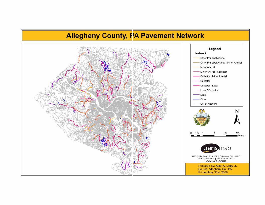
In March 2008, Allegheny County contracted with TransmapCorporation to complete a pavement condition survey of 385miles of streets which exist in unincorporated areas. Underthe scope of this project, the project team inventoried 10different classifications of roadways.
In March 2008, Allegheny County contracted with TransmapCorporation to complete a pavement condition survey of 385miles of streets which exist in unincorporated areas. Underthe scope of this project, the project team inventoried 10different classifications of roadways.
In March 2008, Allegheny County contracted with TransmapCorporation to complete a pavement condition survey of 385miles of streets which exist in unincorporated areas. Underthe scope of this project, the project team inventoried 10different classifications of roadways.
In March 2008, Allegheny County contracted with TransmapCorporation to complete a pavement condition survey of 385miles of streets which exist in unincorporated areas. Underthe scope of this project, the project team inventoried 10different classifications of roadways.

Road Network


Raw Data/Field CollectionRaw Data/Field Collection

Traditional Pavement Collection Method• Inexperienced Rater in
passenger seat of vehicle(Windshield Analysis)
• Missing cracks as theyglance at the roads
• No repeatability/traceability• Analysis at 35 MPH• Fancy laser Smoke Screen
• Inexperienced Rater inpassenger seat of vehicle(Windshield Analysis)
• Missing cracks as theyglance at the roads
• No repeatability/traceability• Analysis at 35 MPH• Fancy laser Smoke Screen
Traditional Pavement Collection Method

Raw Data Collection TechnologyNumber of Cameras• 6 Device Capable• 3 Cameras / 1 LiDAR
Resolution• 1628 x 1236 Color image• 7.5 and 4.8mm lenses• 2448 x 2048 Pavement Camera• 5616 x 3744 Pavement Camera
Distance MeasurementInstrument (DMI)• Best Color Profile to Extract
Assets• Both Stereo / Single Image
Sick LiDAR ScannerLaser Profilometer (rut&ride)Falling Weight Deflectometer
Number of Cameras• 6 Device Capable• 3 Cameras / 1 LiDAR
Resolution• 1628 x 1236 Color image• 7.5 and 4.8mm lenses• 2448 x 2048 Pavement Camera• 5616 x 3744 Pavement Camera
Distance MeasurementInstrument (DMI)• Best Color Profile to Extract
Assets• Both Stereo / Single Image
Sick LiDAR ScannerLaser Profilometer (rut&ride)Falling Weight Deflectometer
Raw Data Collection Technology

Approach - Raw Collection ExplainedFull 360 Degree View
(13 ft spacing)• Accurate Condition Assessment Required
ON-SIGHTVAN
Approach - Raw Collection ExplainedFull 360 Degree View
• Accurate Condition Assessment RequiredPMS CameraPHP PageImage

Full Size View

Ultra HD Pavement CameraUltra HD Pavement Camera

Transmap Automation -LiDAR Laser Mountedon Ultra HD Camera
Raw Laser Point Cloud Data
Transmap Automation -LiDAR Laser Mountedon Ultra HD Camera
Raw Laser Point Cloud Data

Transmap Automation
Transmap collects LiDAR data.LiDAR is used for road slope/contour, automated signdetection/emissivity, and overhead bridge height measurements.
Transmap collects LiDAR data.LiDAR is used for road slope/contour, automated signdetection/emissivity, and overhead bridge height measurements.

Distress AnalysisDistress Analysis

• Raw Data Collectiono Detailed Surface Crack Analysis
• Centerline File in GIS Esri Geodatabase• Network Definition
o Network, Branch, Section, and Inspectiono Family Assignments (Pavements with similar performance characteristics)o Pavement Functional Classification (Primary, Secondary)o Linear Reference Systemo Construction / Major M&R Dates
• Distress Analysiso Alligator Cracking, Edge Cracking, Potholes, Weathering & Raveling,
Transverse/Longitudinal, Block Cracking, Patching & Utility Cut, Rutting• MicroPAVER Loading
o Automated Database Load• PCI Calculations• Web-Based Results/ Reporting
o ArcGIS Server PCI Layero Extents and Location of Distresses
• Ad-Hoc Reportingo In MicroPAVERo Custom Reportso Web-Based
Transmap PMS "Our System"• Raw Data Collection
o Detailed Surface Crack Analysis• Centerline File in GIS Esri Geodatabase• Network Definition
o Network, Branch, Section, and Inspectiono Family Assignments (Pavements with similar performance characteristics)o Pavement Functional Classification (Primary, Secondary)o Linear Reference Systemo Construction / Major M&R Dates
• Distress Analysiso Alligator Cracking, Edge Cracking, Potholes, Weathering & Raveling,
Transverse/Longitudinal, Block Cracking, Patching & Utility Cut, Rutting• MicroPAVER Loading
o Automated Database Load• PCI Calculations• Web-Based Results/ Reporting
o ArcGIS Server PCI Layero Extents and Location of Distresses
• Ad-Hoc Reportingo In MicroPAVERo Custom Reportso Web-Based

Network and Project Level• (M.Y Shahin)o "For roads and parking lots, it is difficult to justify a high
degree of sampling, unless a project-level evaluation is beingperformed". " To limit the resources required for aninspection, a sampling plan was developed so a reasonablyaccurate PCI could be estimated by inspecting only a limitednumber of the sample units in the pavement section".
• (M.Y Shahin)o "For roads and parking lots, it is difficult to justify a high
degree of sampling, unless a project-level evaluation is beingperformed". " To limit the resources required for aninspection, a sampling plan was developed so a reasonablyaccurate PCI could be estimated by inspecting only a limitednumber of the sample units in the pavement section".

Typical Collection Method ASTM D6433-99
Samples - The lowest order of the definedpavement network. All samples mustbelong to a network, branch and section. Allpavement sections will be divided into 300foot pieces, with the sample portion takenfrom the beginning of each 300 foot piece.The length of the sample area will dependon the width of the roadway. Transmaplooks at the total width of the roadway onnon-divided average roads. In general, thegoal is to have sample areas between1,500 sq. ft and 3,500 sq. ft.
Samples - The lowest order of the definedpavement network. All samples mustbelong to a network, branch and section. Allpavement sections will be divided into 300foot pieces, with the sample portion takenfrom the beginning of each 300 foot piece.The length of the sample area will dependon the width of the roadway. Transmaplooks at the total width of the roadway onnon-divided average roads. In general, thegoal is to have sample areas between1,500 sq. ft and 3,500 sq. ft.
Pavement Management forAirports, Roads, and Parking LotsM.Y.Shahin

Transmap Classifies The Type ofCracking and The Extent
Transmap Classifies The Type ofCracking and The Extent

Network and Project Level
• (M.Y Shahin)o "For roads and parking lots, it is difficult to justify a high
degree of sampling, unless a project-level evaluation isbeing performed". " To limit the resources required for aninspection, a sampling plan was developed so areasonably accurate PCI could be estimated byinspecting only a limited number of the sample units in thepavement section".
• Transmap standard is a network level pavement evaluation.The standard network level "systematic random" sample unitis 10-25 percent of the total network reviewed. Due toTransmap "systematic random" standard sampling method,we evaluate an average of 28 percent of the total network.

Why Sample?
• Scott McDonald (Certified MicroPAVER Trainer) says tothink of the pavement analysis like a bell curve.
• Real information is inside the sweet spot.• If you measure too little, the appropriate amount of
information is not getting attributed to the segment.o This will skew your PCI to be higher.
• If you measure too much, you're wasting your time (SameResults).
• Measuring at a specific interval (middle range).

Need to Establish A Constant RepeatableInspection Methodology
• Sample same areas every 3 years depending oncommunities M&R and funding
• Start building Life cycle curves for different pavementfamilies
• Communicate what is really happening to your pavement• Maintain flexibility in adjusting standard inspection
approaches and interpretation of PCI values toaccommodate local conditions (road geometry, trafficpatterns) and M&R strategies
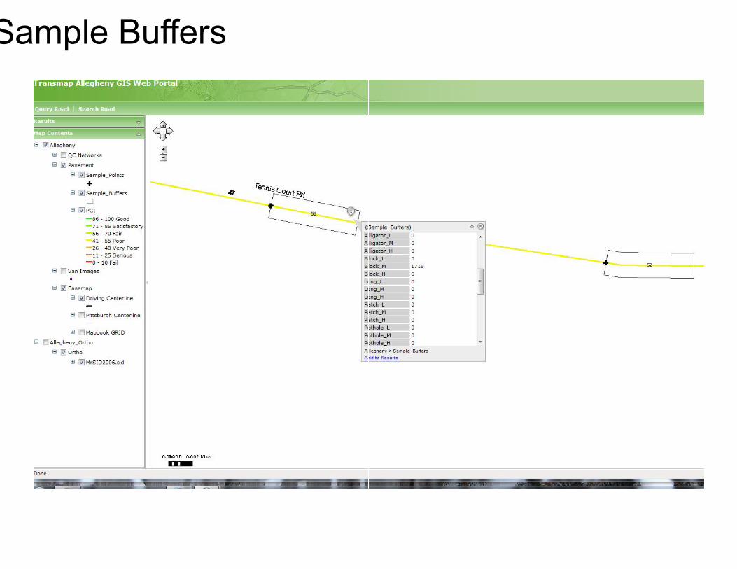
Sample Buffers

Transmap Hybrid Approach
• Repeatability• Real photogrammetric
measurements• Database designed for
analysis (no fat fingers)• Analysis that stands up
to field walk-outs• NOT a windshield survey
• Repeatability• Real photogrammetric
measurements• Database designed for
analysis (no fat fingers)• Analysis that stands up
to field walk-outs• NOT a windshield survey
Transmap Hybrid Approach


MicroPAVERMicroPAVER

• Used by over 600 Cities,Counties, Airports
• Site License only $600 a yearin maintenance
• American Society for Testingand Materials (ASTM)standard D6433-99
• Standard D6433-99 is theonly pavement ratingmethodology recognized forrating road and parking lotpavements
• Full compliance with theModified Approach toaccounting for infrastructurein the GovernmentAccounting Standards Board(GASB) Standard 34


Pavement Management
• Extend the life ofyour pavement
• Defend yourbudget
• APWA and ASTMStandards
• Extend the life ofyour pavement
• Defend yourbudget
• APWA and ASTMStandards
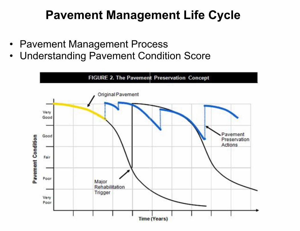
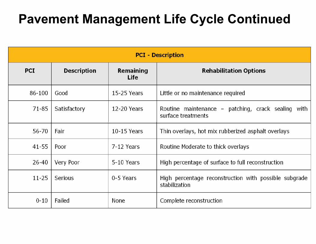
Pavement Management Life Cycle
• Pavement Management Process• Understanding Pavement Condition Score
Pavement Management Life Cycle
• Pavement Management Process• Understanding Pavement Condition Score

Typical Pavement Deterioration CurveTypical Pavement Deterioration Curve
Pavement Management Life Cycle ContinuedPavement Management Life Cycle Continued

Network Level Implementation
• Transmap loads all the sample locations and analysis datainto MicroPAVER in one massive data load.
• The traditional walk-out method is to load the data onesection at a time, while you are collecting distress data.
Network Level Implementation
• Transmap loads all the sample locations and analysis datainto MicroPAVER in one massive data load.
• The traditional walk-out method is to load the data onesection at a time, while you are collecting distress data.

GIS CentricPavement/Asset Management System
GIS CentricPavement/Asset Management System
GIS CentricPavement/Asset Management System
GIS CentricPavement/Asset Management System

GIS Centric• Esri ArcGIS Pavement Centerline• PCI results on centerline• Sample areas defined as polygons
• Esri ArcGIS Pavement Centerline• PCI results on centerline• Sample areas defined as polygons
• Linear Reference System• Work orders linked to ArcGIS• ArcGIS Server applications

GIS Focused
• Everything Transmap does is centered on GISo Roadway features extracted as GIS layero PCI resultso Geodatabaseo ArcGIS Servero Image viewero SDE Server
• Esri Developerso 13 years ESRI Business Partnershipo Value Added Reseller (VAR)o Development Partnero Partners on multi-year City of El Paso, TX project

Web Solutions

Web-Based Solutions- ArcGIS Server
Go to:www.transmap.com/allegheny
Web-Based Solutions- ArcGIS Server

CityworksCityworks

CityworksCityworks is the GIS Centric application that Allegheny CountyPublic Works uses to leverage our road and bridge investments.Cityworks is the GIS Centric application that Allegheny CountyPublic Works uses to leverage our road and bridge investments.

GIS and Cityworks allow our users to select a road or road feature tocreate a work request, review current work on the feature, or gatherhistorical data on the road or road feature.
GIS and Cityworks allow our users to select a road or road feature tocreate a work request, review current work on the feature, or gatherhistorical data on the road or road feature.

The user gets a complete work history of the feature that ishighlighted.The user gets a complete work history of the feature that ishighlighted.

Here is another example of Cityworks ability to track anddisplay work.Here is another example of Cityworks ability to track anddisplay work.

ResultsResults

Overall, the majority of Allegheny County's roadways inunincorporated areas are in the Good or Satisfactory range.
Overall, the majority of Allegheny County's roadways inunincorporated areas are in the Good or Satisfactory range.


The following graphs illustrate various distresses andassociated severity:The following graphs illustrate various distresses andassociated severity:


What's Next?What's Next?

What is Next?
• Re-inspection ofsurface distress every3 years
• Project levelStructural-FallingWeight Deflection(FWD) testing
• Ground penetratingradar (establishasphalt thickness)
• Core Samples• IRI rut data
• Re-inspection ofsurface distress every3 years
• Project levelStructural-FallingWeight Deflection(FWD) testing
• Ground penetratingradar (establishasphalt thickness)
• Core Samples• IRI rut data

Questions?Questions?

Thank you for your time.
Craig Schorling, GISPTransmap CorporationBD/Account [email protected] (Mobile)614-481-6799 (office)
Thank you for your time.
Phil LaMayAllegheny CountyDeputy DirectorAdministration/[email protected](412) 350-7121
Eric AllenAllegheny CountyInformation Systems [email protected](412) 350-5668
Phil LaMayAllegheny CountyDeputy DirectorAdministration/[email protected](412) 350-7121
Eric AllenAllegheny CountyInformation Systems [email protected](412) 350-5668