WHISTLER OLYMPIC PARK VANCOUVER / WHISTLER DRIVING MAP · VANCOUVER / WHISTLER DRIVING MAP HIGHWAY...
2
DIRECTIONS FROM WHISTLER, BC TO HORSESHOE BAY FERRY TERMINAL (109 km / 1 hour 20 minutes) 1. Head South on Highway 99, “Sea to Sky Highway” – 102 km 2. Continue past the Horseshoe Bay turn-off 3. Take Exit 4, the Caulfeild Exit 4. Loop over the overpass (left onto Headland Drive, right onto Woodgreen Drive) – 1 km 5. Proceed west onto Highway 1 to Exit 3, Horseshoe Bay Ferry Terminal – 6 km (Caulfeild Exit) (To Horseshoe Bay Ferry Terminal) HORSESHOE BAY FERRY TERMINAL (Caulfeild Exit) (To Horseshoe Bay Ferry Terminal) Exit 4 Exit 3 99 99 1 4 3 Woodgreen Drive Woodgreen Drive BRANDYWINE FALLS SHANNON FALLS TANTALUS LOOKOUT BRITANNIA BEACH & BRITANNIA MINE MUSEUM ALICE LAKE GARIBALDI PROVINCIAL PARK PORTEAU COVE ALEXANDER FALLS Visitor Centre Cultural Journey Kiosk Lookout Washrooms Museum Waterfall Park Be in the know For the most comprehensive Whistler information, download the new Whistler app now. @ GoWhistler Connect with us: VANCOUVER / WHISTLER DRIVING MAP HIGHWAY INFORMATION 1.800.550.4997 EMERGENCIES 9.1.1 | drivebc.ca DIRECTIONS FROM VANCOUVER AIRPORT TO WHISTLER, BC (137 km / 2 hours 15 minutes) 1. Depart from Vancouver International Airport 2. Continue along Grant McConachie Way and continue to Arthur Laing Bridge – 4.1 km 3. Take the ramp to Granville Street/City Centre – 0.6 km 4. Merge onto SW Marine Drive – 0.2 km 5. Continue on Granville Street – 7.8 km 6. Take the Seymour Street/Highway 99-N ramp to BC Ferries/Horseshoe Bay/Whistler – 0.4 km 7. Merge onto Seymour Street – 1.0 km 8. Turn left at West Georgia Street – 2.0 km 9. Continue through Stanley Park and onto Lions Gate Bridge – 4 km 10. Take the exit toward West Vancouver 11. Merge onto Marine Drive – 0.4 km 12. Turn right at Taylor Way – 0.5 km 13. Continue west on Route 1 to Exit 2 – 14 km 14. Follow Highway 99-N toward Squamish/Whistler 15. Continue to Whistler Village – 101.6 km WHISTLER OLYMPIC PARK WHISTLER TO HORSESHOE BAY FERRY TERMINAL SQUAMISH ADVENTURE CENTRE FURRY CREEK LIONS BAY HORSESHOE BAY WHISTLER.COM | 1.800.944.7853
Transcript of WHISTLER OLYMPIC PARK VANCOUVER / WHISTLER DRIVING MAP · VANCOUVER / WHISTLER DRIVING MAP HIGHWAY...
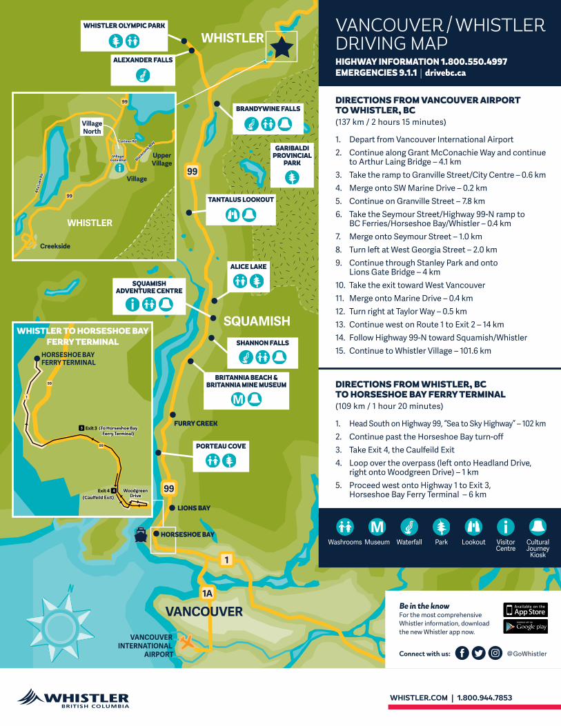
DIRECTIONS FROM WHISTLER, BC TO HORSESHOE BAY FERRY TERMINAL (109 km / 1 hour 20 minutes)
1. Head South on Highway 99, “Sea to Sky Highway” – 102 km2. Continue past the Horseshoe Bay turn-off 3. Take Exit 4, the Caulfeild Exit 4. Loop over the overpass (left onto Headland Drive,
right onto Woodgreen Drive) – 1 km5. Proceed west onto Highway 1 to Exit 3,
Horseshoe Bay Ferry Terminal – 6 km (Caulfeild Exit)
(To Horseshoe Bay Ferry Terminal)
HORSESHOE BAYFERRY TERMINAL
(Caulfeild Exit)
(To Horseshoe Bay Ferry Terminal)
Exit 4
Exit 3
99
99
1
4
3
WoodgreenDrive
WoodgreenDrive
BRANDYWINE FALLS
SHANNON FALLS
TANTALUS LOOKOUT
BRITANNIA BEACH & BRITANNIA MINE MUSEUM
ALICE LAKE
GARIBALDI PROVINCIAL
PARK
PORTEAU COVE
ALEXANDER FALLS
Visitor Centre
Cultural Journey
Kiosk
LookoutWashrooms Museum Waterfall Park
Be in the knowFor the most comprehensive Whistler information, download the new Whistler app now.
@GoWhistlerConnect with us:
VANCOUVER / WHISTLER DRIVING MAPHIGHWAY INFORMATION 1.800.550.4997 EMERGENCIES 9.1.1 | drivebc.ca
DIRECTIONS FROM VANCOUVER AIRPORT TO WHISTLER, BC (137 km / 2 hours 15 minutes)
1. Depart from Vancouver International Airport2. Continue along Grant McConachie Way and continue
to Arthur Laing Bridge – 4.1 km3. Take the ramp to Granville Street/City Centre – 0.6 km 4. Merge onto SW Marine Drive – 0.2 km5. Continue on Granville Street – 7.8 km6. Take the Seymour Street/Highway 99-N ramp to
BC Ferries/Horseshoe Bay/Whistler – 0.4 km7. Merge onto Seymour Street – 1.0 km8. Turn left at West Georgia Street – 2.0 km9. Continue through Stanley Park and onto
Lions Gate Bridge – 4 km10. Take the exit toward West Vancouver11. Merge onto Marine Drive – 0.4 km12. Turn right at Taylor Way – 0.5 km13. Continue west on Route 1 to Exit 2 – 14 km14. Follow Highway 99-N toward Squamish/Whistler 15. Continue to Whistler Village – 101.6 km
WHISTLER OLYMPIC PARK
WHISTLER TO HORSESHOE BAY FERRY TERMINAL
SQUAMISH ADVENTURE CENTRE
FURRY CREEK
LIONS BAY
HORSESHOE BAY
WHISTLER.COM | 1.800.944.7853

Aptly named the “Sea to Sky Highway,” Highway 99 links Vancouver to Whistler via some of the most spectacular coastal wilderness in the world. Upgraded, widened and divided for the 2010 Olympic and Paralympic Winter Games, the highway flanks Howe Sound, the southernmost fjord in North America, and serves up uninterrupted views of the dramatic glaciers of the Coast Mountains.
DISCOVER SEA TO SKY COUNTRY
PORTEAU COVE PROVINCIAL PARK A scuba diving hotspot, thanks to several shipwrecks and artificial reefs, Porteau Cove features picnic tables, public washrooms, a large driftwood-littered pebble beach, a public jetty and a boat launch.
BRITANNIA BEACH & BRITANNIA MINE MUSEUM The town of Britannia Beach was originally centred around an active copper mine that has now become the Britannia Mine Museum. This natural historic site, is a great stop for families and history buffs, and has been used as a location for more than 50 films and television shows such as the X-Files, Smallville, Dark Angel, Stargate, Insomnia and Scooby Doo Two.
SHANNON FALLS With a dramatic 335 metre (1,100 foot) drop, not only is Shannon Falls the third highest waterfall in BC and formerly the key ingredient in Carling O’Keefe beer, but it was also featured in the Twilight movie, Breaking Dawn. Take the 5-minute stroll to the base of the falls. Washrooms and picnic tables are located by the parking area.
ALICE LAKE PROVINCIAL PARK This 397 hectare campground, in a forest of old-growth hemlock, features hiking and biking trails, picnic areas, two protected beaches and the popular Alice Lake itself.
TANTALUS LOOKOUT With pull-outs for both north and southbound traffic, and incredible views of the peaks named for the Greek myth, the Tantalus Range is the vista that lets locals know they’re almost home.
GARIBALDI PROVINCIAL PARK Running east of the Highway, the 195,000 hectare Garibaldi Provincial Park contains several ancient volcanoes — including Mount Garibaldi — more than 90 kilometres of hiking trails and several huts. It was protected in 1927 to preserve the “remarkable assemblage of glacial, volcanic and other natural features.”
BRANDYWINE FALLS An easy 10-minute walk through the forest leads to a new viewing platform of the falls perched on the edge of a volcanic escarpment. The 143 hectare park features a picnic area, trails and washrooms. Park gates are closed in Winter from November to May.
ALEXANDER FALLS Located in the Callaghan Valley just 10 km south of Whistler, near Whistler Olympic Park, this beautiful 3-tiered waterfall is easy to access from the viewing platform right next to the parking lot, with no walking or hiking required to view.
WHISTLER OLYMPIC PARK A 7,000 hectare wilderness, known to the Squamish First Nation as a ‘Wild Spirit Place,’ Whistler Olympic Park was developed as the site of the cross-country, biathlon, Nordic combined, and ski jumping events for the 2010 Olympic and Paralympic Winter Games. The 6.5 kilometre Callaghan Valley access road is a popular bear-spotting stretch, and the Park’s Visitor Centre, and café / restaurant, is open seasonally.
The opportunities to sightsee and to enjoy the pristine natural beauty of British Columbia begin on your drive to Whistler.
Photos: Chad Chomlack, Mike Crane
VANCOUVER TO WHISTLER: A JOURNEY TO REMEMBER
Tips for the driveKeep an eye out for some of the area’s incredible wildlife as you travel through Sea to Sky country, and have your camera ready for when you do spot a black bear, cougar, deer or bald eagle. But remember, these are wild animals that are best viewed from a safe distance. Never stop to view wildlife when driving. This stresses wildlife and creates unsafe road conditions due to traffic congestion.
Summer is also forest fire season in British Columbia, so please be fire smart:• Never toss a lit match.
• Extinguish cigarettes completely.
• Do not discard cigarettes and matches from vehicles or off your balconies and decks. Always use an ashtray.
• Take the time to become fire aware: check for advisories on highway signs, on the radio and in the newspaper, or call 1.888.3.FOREST for pre-recorded fire information updates.
• Obey all backcountry and trail closures and fire bans.
Highway 99 is a mountain highway, please ensure your vehicle is properly equipped for the changing conditions, including Winter rated tires from October 1 – March 31. Visit drivebc.ca for more information, road conditions and live webcams, or call 1.800.550.4997.
Get the latest news and traffic updates from the area’s local radio station, Mountain FM (107.1 FM in Squamish and 102.1 FM in Whistler).
Once you arrive in Whistler, be sure to stop by the Whistler Visitor Centre to learn more about Whistler and all of the activities that are available in the resort.
Cultural Journey
Kiosk
LookoutWashrooms Museum Waterfall Park
The 123 kilometre (76 mile) journey to Whistler travels through five distinct bio and geo-climatic zones dotted with waterfalls, rainforest, granite monoliths (the 60 million year old Stawamus Chief is the largest piece of free-standing rock outside of Gibraltar), wilderness areas and snow-capped peaks, and it was declared by the UK’s Guardian newspaper to be one of the world’s five best road trips. Information kiosks from the Lil’wat and Squamish First Nations provide a parallel cultural journey and added incentive to stop and soak up the views along the way.
WHISTLER.COM | 1.800.944.7853