Which are the continents that are situated only on the ... Science_II... · people here is sheep...
17
We have learnt from the previous units that at one point of time, all the continents that we see today were a single mass of land and due to internal forces of the earth it divided and drifted to form seven continents. Let us learn more about some of the continents on the earth. Continents are extensive masses of land surrounded by oceans. With the help of globes and fig. 5.1 we can examine how these continents are distributed on the earth. Which is the continent that lies entirely on the southern hemis- phere? Which are the continents that are situated only on the northern hemisphere? Which are the continents that extend to both the hemispheres? Is there any continent which lies entirely on the polar region? Which is the temperature zone in which this continent is located? Which are the oceans surrounding this continent? Fig. 5.1
Transcript of Which are the continents that are situated only on the ... Science_II... · people here is sheep...

We have learnt from the previous unitsthat at one point of time, all thecontinents that we see today were asingle mass of land and due to internalforces of the earth it divided and driftedto form seven continents.
Let us learn more about some of thecontinents on the earth.
Continents are extensive masses of landsurrounded by oceans.
With the help of globes and fig. 5.1 wecan examine how these continents aredistributed on the earth.
Which is the continent that liesentirely on the southern hemis-phere?
Which are the continents that aresituated only on the northernhemisphere?
Which are the continents that extendto both the hemispheres?
Is there any continent which liesentirely on the polar region?
Which is the temperature zone inwhich this continent is located?
Which are the oceans surroundingthis continent?
Fig. 5.1
Standard - IX
Social Science - II70 Fig. 5.2
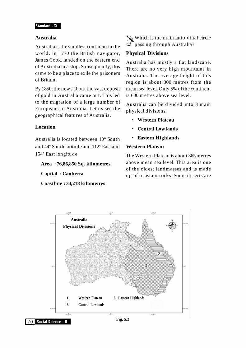
Australia
Australia is the smallest continent in theworld. In 1770 the British navigator,James Cook, landed on the eastern endof Australia in a ship. Subsequently, thiscame to be a place to exile the prisonersof Britain.
By 1850, the news about the vast depositof gold in Australia came out. This ledto the migration of a large number ofEuropeans to Australia. Let us see thegeographical features of Australia.
Location
Australia is located between 10° Southand 44° South latitude and 112° East and154° East longitude
Area : 76,86,850 Sq. kilometres
Capital : Canberra
Coastline : 34,218 kilometres
Which is the main latitudinal circlepassing through Australia?
Physical Divisions
Australia has mostly a flat landscape.There are no very high mountains inAustralia. The average height of thisregion is about 300 metres from themean sea level. Only 5% of the continentis 600 metres above sea level.
Australia can be divided into 3 mainphysical divisions.
• Western Plateau
• Central Lowlands
• Eastern Highlands
Western Plateau
The Western Plateau is about 365 metresabove mean sea level. This area is oneof the oldest landmasses and is madeup of resistant rocks. Some deserts are
Australia
Physical Divisions
1. Western Plateau 2. Eastern Highlands
3. Central Lowlands
1
2
2
3

Chapter - 5
CONTINENTS 71
Murray RiverFig. 5.3
concentrated in the middle of thisplateau. Find them out from the atlas.
Central Lowlands
This physical division can be furtherdivided into three.
They are :
1. Great Artesian Basin
2. Eyre Basin
3. Murray - Darling region.
The Great Artesian Basin is the largestsource of underground water in theworld. Using the underground water inthis region, agriculture has flourished.
Eyre Basin is a very important regionof the Central lowlands. The rivers inthis region do not flow into the sea, butinto the Eyre lake which is about 100metres below the sea level.
Two important rivers flowing from theeastern highlands are the Murray andthe Darling.
The Murray is 2,574 kilometres long anddoes not dry up in summer. Anotherriver which is rich in water is theDarling river. The Murray -Darlingbasin is a very fertile region in Australia.
Eastern Highlands
They are situated parallel to the easterncoast, 2000 kilometres long and arearch-shaped. The average height of thisplace is 900 metres above mean sealevel. The eastern side of the EasternHighlands slopes steeply whereas thewestern side is not so steep. BlueMountain Ranges and Australian Alps,are the important mountains of thisregion. The source of the Murray andDarling rivers originate from theEastern Highlands. These rivers areimportant for the generation of hydroelectric power in Australia.
Major Rivers of Australia
The longest river in Australia is theMurray river. The Murrumbidgee,

Standard - IX
Social Science - II72
Compare this (Table 5.1) tothe seasons in India. What
differences have you noticed? Why is it so?Discuss in the class.
People in Australia celebrateChristmas in summer. When do youcelebrate Christmas and why?
There are three main factors thatinfluence the climate of Australia.
• Latitude
• Position of the mountains.
• Nearness to the sea.
In this continent the tropical and thetemperate climates are experienced. Themountains that run parallel to theeastern coast are known as the Easternranges. They obstruct the moistureladen winds and causes heavy rain onthe eastern side. The leeward side of therange is a rain shadow region. Duringsummer, cyclones are common on thewestern plateau region. The depressionsthat form in the region attract themonsoon winds to Australia and causerainfall in the west.
The differences existing in thephysiographical features and climatepresent different types of naturalvegetation.
Climatic regions and NaturalVegetation
Monsoon region
The northern side of Australia
Darling, Lachlan, Cooper Creek,Flinders and Diamantina are the otherimportant rivers.
Find out from the atlas theregions through which the
main rivers of Australia flow.
Great Barrier Reef
Made up of coral, the Great Barrier Reefis situated on the north eastern side ofAustralia and is more than 2000kilometres long. This is an ecosystem ofdifferent types of fish and algae. It is oneof the notable tourist spots of the world.
Do these physical features influence theclimate of Australia? Let us examine.
Climate
Study from the table (Table 5.1) theseasons in Australia and the months inwhich they fall.
Seasons Months
Summer December, JanuaryFebruary
Autumn March, AprilMay
Winter June, July, August
Spring September, OctoberNovember
Table 5.1
Chapter - 5
CONTINENTS 73
experiences the monsoon type ofclimate. During summer there is heavyrain. When the monsoon winds reachesthe interior parts of the continent,humidity decreases and it becomes dry.In winter, that is, in the months of June,July and August, there is no rain in thisregion. You can see temperate forestshere. Mangrove forests can be foundnear the sea. In regions where theclimate is dry, eucalyptus forests arefound.
South East Trade Wind Region
On the eastern side of the continent, itrains throughout the year. The windsthat blow from the southeast all yearround, makes it rain there. On thewestern side of the Tropic of Capricornrain forests can be found.
Hot Desert Regions
Hot deserts stretch from the eastern partof the Central lowlands to the westerncoast. This is called the Great AustralianDesert. The average rainfall in a year isless than 25 cms. Shrubs and thornybushes are the main vegetation.
Grasslands
Between the forests and the deserts liethe Great Grasslands. The grasslandslying on the north of the Tropic ofCapricon is called the Savanna. Thegrasslands on the southern side arecalled the Downs. On the grasslands,eucalyptus and accacia trees can beseen. The main occupation of the peoplein the Downs is wheat cultivation andsheep rearing.
Mediterranean region
The regions on the southern end ofAustralia experience the Mediterraneantype of climate. Perth and Adelaide arein this region. In winter, the winds thatblow north west bring a lot of rain inthis region. Summers are dry and hot.Orange, grape and wheat grow well inthis region.
Tasmania
The Tasmanian islands are situated onthe southern end of Australia. Thenorthwest winds bring rain throughoutthe year. On the wetland in the westernside of Tasmania, pine and peach treesgrow, and on the dry eastern side,different types of eucalyptus trees arefound.
Life of the people
Almost 88% of the people of Australiaare the descendants of people whomigrated from Europe. Today peoplefrom all parts of the world havemigrated to Australia. Agriculture,sheep and cattle rearing industry andfishing are the main occupations of thepeople.
Agriculture
Most of Australia is desert like or a semidesert. Only 4% of the land can befarmed. The Murray- Darling basin onthe south eastern side and the southwestern side are fertile and wet. So it isconducive to farming. Theunderground water is used for all

Standard - IX
Social Science - II74
purposes. Wheat, paddy, sugarcane,corn, barley, tobacco are the main crops.Banana, papaya, pineapple, grapes,orange, apple are the fruits grown here.
Sheep Farming
There are vast grasslands in Australia.One of the many occupations of thepeople here is sheep rearing. Australiahas the largest number of sheep in theworld. Australia has an important placein the production and export of wool ofthe best quality. Cattle farming is also avery important occupation here. Cattleis reared for meat and dairy products.
Calgoorlie gold mineFig. 5.5
Fig.5.4
Fishing
Australia has one of the biggest fishingindustries of the world. DarwinHarbour is the most important fishingharbour here. Fish processing and
Agro based industries and mineralbased industries are well developed inAustralia. Cotton and woollen textiles,sugar, dairy products, processed foods,leather products, are industries basedon agricultural products.
Iron ore smelting, aluminium industry,ship building, oil extraction andchemical industries are the industriesbased on minerals.
manufacture of fish products providejobs for the people in villages.Uncontrolled fishing has proven to bea threat to the marine wealth.
Minerals
Australia is a storehouse of differentminerals. Coal, iron ore, bauxite, gold,and petroleum are the main mineralsfound here. Calgoorlie and Coolgardyare famous for their gold mines.
Industry
Chapter - 5
CONTINENTS 75
Bays Islands
Name Location Name Location(Ocean) (Ocean)
Fig. 5.6
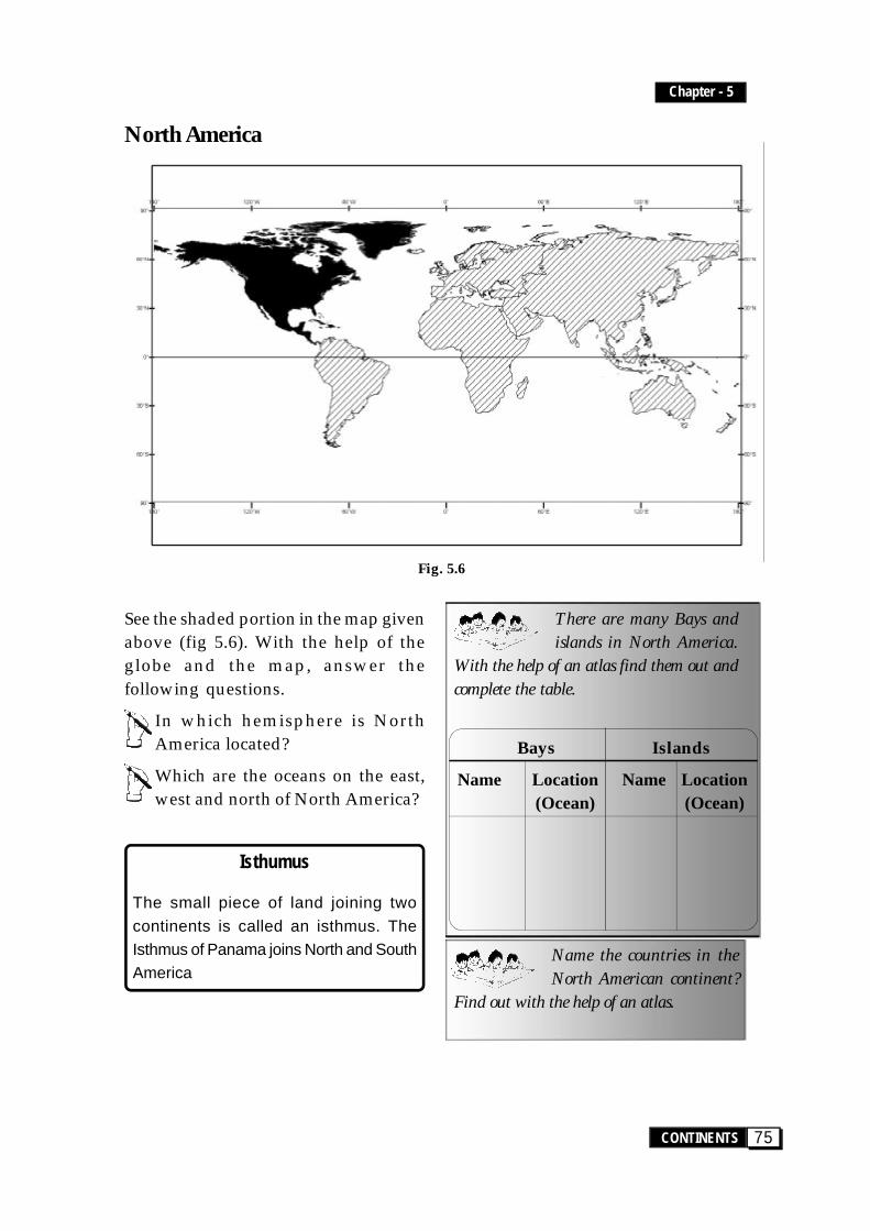
North America
See the shaded portion in the map givenabove (fig 5.6). With the help of theglobe and the map, answer thefollowing questions.
In which hemisphere is NorthAmerica located?
Which are the oceans on the east,west and north of North America?
Isthumus
The small piece of land joining twocontinents is called an isthmus. TheIsthmus of Panama joins North and SouthAmerica
There are many Bays andislands in North America.
With the help of an atlas find them out andcomplete the table.
Name the countries in theNorth American continent?
Find out with the help of an atlas.

Standard - IX
Social Science - II76
1. Canadian Shield
3. Eastern highlands
2. Central lowlands
4. Western Cordilleras
Fig. 5.7
North America is the third largestcontinent. It is 24 million sq kilometres.It extends from 7°N to 85°N latitude and20°W to 179°W longitude.
Which are the important latitudinalcircles that pass through NorthAmerica?
It was while he was travelling to India thatChristopher Columbus came acrossNorth and South America. But it was in1507, after the Italian Amerigo Vespuccilanded in South America that the nameAmerica came to be.
North America - Physical Divisions
Physical Features
North America can be divided into fourmajor physical divisions. They are:
• The Canadian shield.
• The Eastern highlands.
• The Central lowlands.
• The Western Cordilleras
Find out the location of thesedivisions from the map
Canadian Shield
The Canadian Shield is made up of veryold, hard rocks. Many small riversoriginate here and flow into the Hudson
1
23
4
Chapter - 5
CONTINENTS 77
Bay. There are five famous lakes in thisarea. They are Lake Superior, LakeMichigan, Lake Huron, Lake Erie andLake Ontario. They are known as theFive Great Lakes.
The river St. Lawrence is an importantinland waterway of North America. TheCanadian Shield is a storehouse ofminerals like nickel, gold, copper andsilver.
Niagra Waterfall
The Niagra Waterfall is situated on theriver Niagra that lies between the UnitedStates of America and Canada. It includesthree different waterfalls- the Horse shoe,the American and the Bridal Veil. Theapproximate height of this extensivewaterfall is 52 metres. This is the mostfamous waterfall in the world.
The Eastern Highlands
The Eastern Highlands are also knownas the Appalachian mountains. They areold fold mountains are also known asthe Eastern Highlands. Its averageheight is 900 metres above mean sealevel. The highest peak here is MountMitchell which is 2037 metres high.
The Central Lowlands
You have noticed the location of theCentral Lowlands from the map (fig.5.7). This is the agricultural zone ofNorth America. It stretches 6000kilometres east to west in the south fromthe Gulf of Mexico in the south to theMackenzie river basin in the north. TheMissouri and Mississippi riversprovide the southern part of theseplains with rich alluvial deposits andabundant water supply.
The Western Cordilleras
This region is made up of manymountain ranges. These ranges extendfrom Alaska to Panama and are youngfold mountains. The maximum widthof this range is 1500 kilometres. Thewidth decreases towards the north andsouth ends of these ranges. The Rockiesmountains are situated on the easternpart of these ranges. Cascade Range, theSierra Nevada and Sierra Madre aresome of the other mountain ranges ofthe region. Mount McKinley in theAlaska range is the highest peak (6194metres) in North America. There aremany plateaus in these ranges. AlaskaPlateau, the Columbia Plateau, and theColorado Plateau are some of them.
The rivers in North America play a veryimportant role in the natural sceneryand life of people of this region. TheMississippi is one of the most importantrivers in this area. Missouri, Mackenzie,Ohio, Rio Grande, St. Lawrence andYukon are the other important rivers.
Climate
Extending from the Tropical zone to theFrigid zone, the climate of NorthAmerica is varied.
A major part of North America lies inthe temperate zone and a very smallpart in the Frigid Zone and the Tropics.The factors that influence the climateare:
• Nearness to the ocean
• Mountain Ranges
• Ocean currents

Standard - IX
Social Science - II78
Find out which are the oceancurrents that influence the
climate of North America. Prepare notes.
Climatic Regions and NaturalVegetation
Tundra Region
This region which includes the HudsonBay is situated to the north of the Arcticcircle (66½°N). Severe cold and a longwinter is experienced here.
The Taiga Region
Extending from New Foundland in theeast to Alaska in the west, coniferousforests can be seen. Warm and shortsummers are experienced here. Themain occupation here is lumbering andfur trade.
The Temperate East Margin Region
This region is located to the east of thegreat lakes and the Appalachianmountains. Due to the influence of theCold Labrador Current in the west,winters are very cold. Rain isexperienced here in summer. But in thesouth the summers are comparitivelyhot and winters are mild. This coastalregion experiences cyclonic winds likeHurricane and Tornado.
Cool Temperate Western Margins
This region extends from the north ofCalifornia to Alaska. The warm Alaskacurrent that flows through these shoresmake the summers hot and winters cool.The proximity to the Rocky mountainshelps in ensuring heavy rainfall in theregion. Coniferous forests are mostlyfound here.
The Prairie Grasslands
This region extends from the south ofTaiga, the region between the GreatLakes and the Rockies, to the Missouri -Mississippi basin. Short grass is thevegetation seen in this region. To theeast of100°W meridian, where there ishigh rainfall, the grasslands areextensively cleared for the cultivation ofwheat, corn and cotton. This area isknown as the granary of wheat.
The Mediterranean Type of Climate
This climate is experienced in centralCalifornia which is located in thewestern coast of North America. Thiswestern climatic region lies between30°N and 40°N latitudes. It rains herein winter. Fruits like orange and grapesgrow extensively here.

Chapter - 5
CONTINENTS 79
Hot Desert
This region is on the south western partof North America, on the east of theRocky mountain range. Summers arevery hot and winters are very cold here.It rains very little in this region and onlythorny bushes and a variety of grassesare mainly found here.
Tropical Rain Forests
This forest is found in Central Americaand the West Indies. This region ischaracterized by heavy rainfall andhigh temperature .
Life of the people
Let us see how the physiography andclimate of North America affects the lifeof the people. The density of populationin India is 279 People per sq. kilometrebut that of North America is even lessthan 20.
Agriculture
Only10% of the total area of NorthAmerica is suitable for agriculture. TheCentral Plains is the main agriculturalarea of the continent. Fertile soil,availability of water suitable climate,vast agricultural lands, mechanisation,all make this area ideal for theadvancement in agriculture. Wheat,corn, oats, barley etc are the major crops.North America is a major producer ofwheat in the world. Corn is the nextimportant crop. Warm climate and
intermitent rain are ideal for growingcorn. Corn is the main food grain usedby people of Mexico. But in the UnitedStates and Canada, corn is mainly usedas cattle feed.
On the coast of Mexico and West Indieswhere the climate is hot and moist, riceis cultivated. Cotton, tobacco,sugarcane, coffee, cocoa are the maincash crops grown here. Other than these,grapes, orange, apple, peach, apricotare also grown on a large scale inCalifornia.
Dairy Farming
One of the main occupations of theNorth American people is dairyfarming. The vast grasslands here isconducive to rearing cattle. In the northeastern parts of the United States ofAmerica and in the adjacent regions ofCanada, it is seen on a large scale. In thedry areas of the Rockies, sheep arereared for wool and meat. Pigs for meatand fowl for meat and eggs are rearedon a commercial basis.
Fishing
Fishing is the other importantoccupation of the people in the region.North America has oceans on threesides. In the shallower areas of thePacific and the Atlantic oceans a lot ofplankton is seen, which makes afavourable situation for the availabilityof fish. You have heard of the GrandBanks to the east of New Foundland.The other fishing centres in the Atlantic
Standard - IX
Social Science - II80
Fig. 5.8
are St. Pier Bank, Sable Island Bank,Browns Bank and Georges Bank. NorthAmerica holds the third place in theproduction of fish in the world.
Industry
The large deposits of minerals and ores,especially those which are energyresources, and the availability ofagricultural and forest products havehelped America in industrialdevelopment. The willingness of theAmerican people to work hard and theirentrepreneurial inclinations are reasonsfor their flourishing industries. Theimportant industries here are iron oresmelting, automobile industry, shipbuilding, production of agriculturalmachinery, cotton textiles, woollentextiles, paper, fertilizer, paint, electrical
and electronics products, computerhardware and software.
What are the geographicalfactors that have helped
North America in industrial development?Discuss.
Which continent exists ascontinuation of North America?
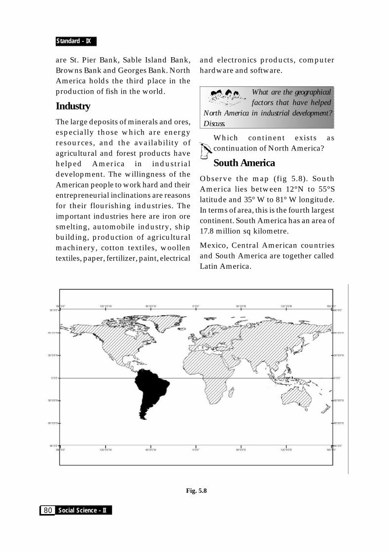
South America
Observe the map (fig 5.8). SouthAmerica lies between 12°N to 55°Slatitude and 35° W to 81° W longitude.In terms of area, this is the fourth largestcontinent. South America has an area of17.8 million sq kilometre.
Mexico, Central American countriesand South America are together calledLatin America.

Chapter - 5
CONTINENTS 81
What is the name of the Isthmus thatjoins North and South America?
Where is the Panama canalsituated?
How is Panama canal helpful toseafarers?
Locate in the atlas Cape Hornwhich is situated on the
southern end of South America.
On which side of South America isthe Magellan Strait? Which are thelandmasses that are separated by it?
The Panama Canal
The Atlantic and the Pacific oceans havebeen joined by the 77 kilometre longPanama Canal. This was officially openedon August 15, 1914. Thousands of shipspass through the Panama Canal annuallyinto the Atlantic and the Pacific oceans.
Find out the countries ofSouth America from the atlas.
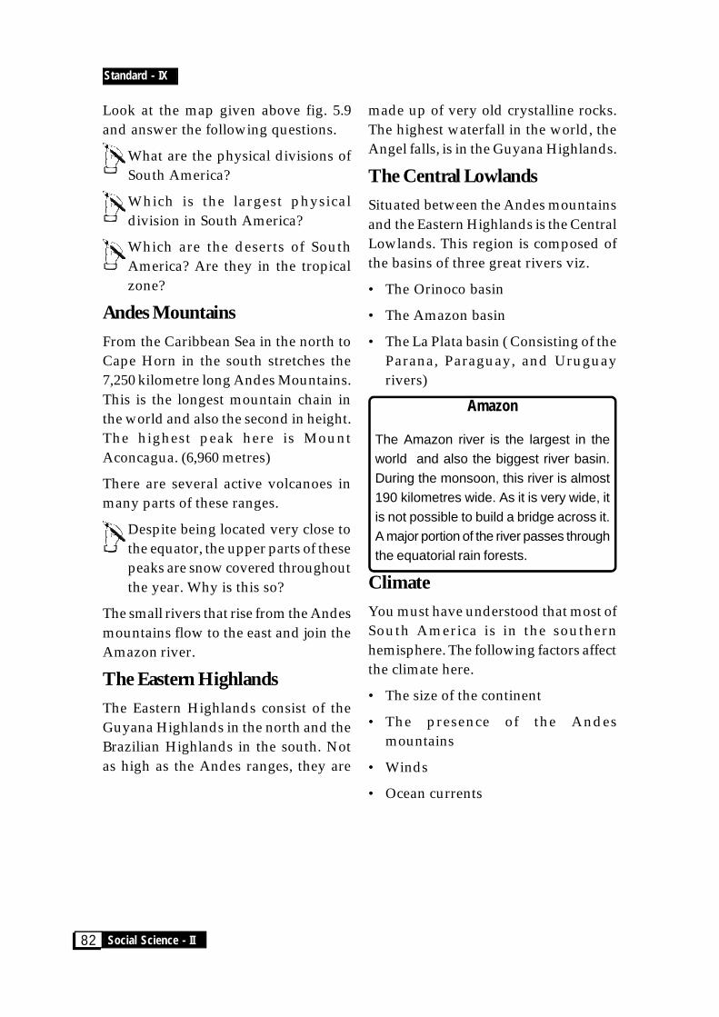
Fig. 5.9
South America - Physical Division
Amazon Basin
Central Lowlands3 Brazilian Highlands2
Patagonia
Magallan Strait
The P
acifi
c Ocea
n
The A
tlanti
c Ocea
n
Andes Mountains
1. Andes Mountains 2. Eastern Highlands3. Central Lowlands
Guana Highlands2
Physical Features
Standard - IX
Social Science - II82
Look at the map given above fig. 5.9and answer the following questions.
What are the physical divisions ofSouth America?
Which is the largest physicaldivision in South America?
Which are the deserts of SouthAmerica? Are they in the tropicalzone?
Andes Mountains
From the Caribbean Sea in the north toCape Horn in the south stretches the7,250 kilometre long Andes Mountains.This is the longest mountain chain inthe world and also the second in height.The highest peak here is MountAconcagua. (6,960 metres)
There are several active volcanoes inmany parts of these ranges.
Despite being located very close tothe equator, the upper parts of thesepeaks are snow covered throughoutthe year. Why is this so?
The small rivers that rise from the Andesmountains flow to the east and join theAmazon river.
The Eastern Highlands
The Eastern Highlands consist of theGuyana Highlands in the north and theBrazilian Highlands in the south. Notas high as the Andes ranges, they are
made up of very old crystalline rocks.The highest waterfall in the world, theAngel falls, is in the Guyana Highlands.
The Central Lowlands
Situated between the Andes mountainsand the Eastern Highlands is the CentralLowlands. This region is composed ofthe basins of three great rivers viz.
• The Orinoco basin
• The Amazon basin
• The La Plata basin ( Consisting of theParana, Paraguay, and Uruguayrivers)
Amazon
The Amazon river is the largest in theworld and also the biggest river basin.During the monsoon, this river is almost190 kilometres wide. As it is very wide, itis not possible to build a bridge across it.A major portion of the river passes throughthe equatorial rain forests.
Climate
You must have understood that most ofSouth America is in the southernhemisphere. The following factors affectthe climate here.
• The size of the continent
• The presence of the Andesmountains
• Winds
• Ocean currents

Chapter - 5
CONTINENTS 83
Most of South America experienceshot and moist tropical climate.What are the factors influencingthis?
The capital of Ecuador, Quetta, isclose to the equator but experiencescold weather. Why?
Find the answers with the help ofthe physical and political maps ofSouth America.
Climatic Regions and NaturalVegetation
Humid Equatorial climate.
This climate is mainly experienced inthe Amazon basin. There is not muchheat or rain in the regions of Andesmountains. But in the Ecuador plateau,it is cold and there is low rainfallthroughout the year. The Amazon basinexperiences high temperature andheavy rainfall throughout the year. Inthis region there are tropical rain forestswhich grow luxuriantly. These arecalled Selvas. The main trees seen hereare mahogany and ebony.
Tropical Grasslands or The Savan-nah
The Savannah are seen in two regions.North of the equator in the Orinocobasin they are called Llanos and southof the equator in the Brazilian highlandsthey are called Campos. In summer, this
region receives a lot of rain. On theeastern side of this region coffeeplantations can be seen.
Gran Chaco region
This region lies between the BrazilianHighlands and the Andes. This regiondoes not receive much rain.
Pampas
Pampas are the temperate grasslands ofArgentina. Though it is cool throughoutthe year, in summer this region receivesvery little rain. The main occupation ofthe people of this region is wheatcultivation and rearing cattle and sheep.
Patagonia
This is a temperate desert. It lies on theeastern side of the Andes mountains.Bushes are the main vegetation.
Andes region
It extends from north to south on thewestern side of the continent. Inaccordance with the height of the placethe vegetation also varies. At the footof the mountains, rain forests can beseen and as we go higher, grasslandsand coniferous forests can be seen.
Pacific Coastlands
This is the region between the Andesmountains and the Pacific ocean. On thenorthern side, evergreen forests andswamps can be seen. From the south of
Standard - IX
Social Science - II84
this to the north of Chile lies theAtacama desert. In central Chile whichenjoys Mediterranean climate, manyorchards can be seen. West of 40°Slatitude, the coastline is not continuous.
El Nino
Every 3 to 7 years, during Christmas, thePacific Ocean along the coast of Peruheats up. It is the fisher folk who first takenotice of this. They named it El Nino. Thisphenomenon changes the climate of Peruand causes heavy rain or drought.
Life of the people
Physiography and climate of SouthAmerica affect the life of the people toa great extent. The total population ofSouth America is 370 million. The denseforests of the Amazon, the steep slopesof the Andes, the rugged and rockyterrains of Guyana basin, havesignificantly affected the life of thepeople.
People are found concentrated in coastallands where there is fertile soil, suitableclimate, and better transportationfacility. Most people have settled downin villages. The main occupation ofmore than half of the population isagriculture. Wheat and corn are themain crops. Coffee, cocoa, sugarcane,cotton and plantain are also cultivatedhere.
Cattle Rearing
As South America has vast grass lands,cattle rearing has become an importantoccupation. They are reared for meat,milk and dairy products. Meatprocessing is an important industry. Inthe dry regions like Argentina andChile, large scale sheep farming is alsodone.
Fishing
About 20% of the total fish catch in theworld is from South America. Thecoasts of Peru and Chile are some of themain fishing centres of the world.
Minerals
Many mineral deposits are found inSouth America. Venezuela, Columbia,Ecuador, Venezuela, Chile are rich inoil deposits. Brazil and Peru have ironore deposits, Peru and Chile havecopper deposits; tin deposits are seenin Bolivia and bauxite deposits areavailable in Guyana and Brazil. Coal,manganese, silver, zinc, gold, platinum,mercury are also mined in smallquantities.
Industry
The availability of all these mineralshave paved the way for industrialgrowth in South America. Iron and Steel,

Chapter - 5
CONTINENTS 85
cotton textiles, woollen textiles, sugar,food processing, oil refining, chemicals,leather, automobile are the majorindustries.
Brazil, Argentina, Uruguay, Venezuela,Peru and Chile are the main industrialzones.
Follow up Activities...
• Prepare a magazine on the continentsof Australia, North America andSouth America.
Points to be included
• Countries included in the continents
• Their capitals
• Currency
• Language spoken
• Crops
• Industry
• Minerals
• Tourism
With the help of the atlas, fill the tablegiven below with details regarding thephysical divisions to which the townsmentioned belong.
Town Physical Divisions
Nusa
Brum
Albany
Canberra
Horsham
• Are the conditions that influence theclimate of the continents of Australia,North America and South Americathe same? Analyse and arrive at aconclusion.