What do developing countries need from the BIOMASS mission ...
30
What do developing countries need from the BIOMASS mission for REDD+ forest monitoring and reporting Adam Gerrand, with thanks for input from Inge Jonckheere, Johannes Broetz FAO / UN-REDD 1
Transcript of What do developing countries need from the BIOMASS mission ...

What do developing countries need from the BIOMASS mission for
REDD+ forest monitoring and reporting
Adam Gerrand, with thanks for input from
Inge Jonckheere, Johannes Broetz FAO / UN-REDD
1

2
Outline of talk
1. Why forests are important for climate change mitigation [known] 2. What is REDD+ (plus)? Why its important, and how it can help 3. BRIEF outline of national forest monitoring system for REDD+
under the UNFCCC 4. IPCC’s guidelines for measurement, reporting and verification
(MRV) for REDD+ [Simon has covered this] 5. The tropics is where it matters most, but still aim for global 6. RS Capacity gaps in countries – a quick quiz! 7. What products should BIOMASS produce? BIOMASS products
need to be tailored to meet national users needs 8. BIOMASS could focus on hotspots of high biomass & high change 9. Suggestions for BIOMASS mission to consider

What is REDD+ (plus)?
• Idea developed to reduce emissions from forest conversion • REDD is incentive mechanism for developing countries to
protect & better manage forests, reducing GHG emissions & provide climate benefits
• REDD+ (REDD plus) strategies go beyond Reducing Emissions from Deforestation and Degradation, adding +: – the role of conservation (of forest carbon) – sustainable management of forests (production, livelihoods) – enhancement of forest carbon stocks in reducing emissions.

Reference Period
Emissions (Gt CO2)
Year
Projection
Actual Emissions
How REDD works to reduce GHG (one simplified option)
Emissions Reductions
Green shaded area is reduced emissions from REDD+ actions

UNFCCC Decision 4/CP.15: Copenhagen (2009) Requests developing country Parties on issues relating to measurement and reporting (M&R): (c) To use the most recent IPCC guidance and guidelines … as a basis for estimating anthropogenic forest-related greenhouse gas emissions by sources and removals by sinks, forest carbon stocks and forest area changes
d) To establish, according to national circumstances and capabilities, robust and
transparent national forest monitoring systems and, if appropriate, sub-national systems as part of national monitoring systems that: i. Use a combination of remote sensing and ground-based forest carbon inventory
approaches for estimating, as appropriate, anthropogenic forest-related greenhouse gas emissions by sources and removals by sinks, forest carbon stocks and forest area changes
ii. Provide estimates that are transparent, consistent, as far as possible accurate, and that reduce uncertainties, taking into account national capabilities and capacities
iii. Are transparent and their results are available and suitable for review as agreed by the Conference of the Parties
7
MEASURABLE
REPORTABLE
VERIFIABLE
= MRV

The UNFCCC: Warsaw (2013)
Decision 14/CP.19: Modalities for measuring, reporting and verifying Annex: Guidelines for elements to be included in the technical annex 1. Summary information from the final report containing each
corresponding assessed FREL/FRL 2. Results in tCO2e/year, consistent with the assessed FREL/FRL 3. Demonstration that the methodologies are consistent with those
used to establish the assessed FREL/FRL 4. A description of national forest monitoring systems (NFMS) and the
institutional roles and responsibilities for MRV 5. Necessary information that allows the reconstruction of the results
8

REDD+ requires NFMS and FREL • To be eligible for REDD+ payments countries must prepare
1. National Forest Monitoring System (NFMS) and 2. Forest Reference Emission Level or Forest Reference Level (FREL/FRL)
• Requires remote sensing for consistent historical land-use change • Countries using data from past 5, 10, 15, some up to 20 years • For BIOMASS to be most useful there will need to be a good
understanding of the relationships between the results from other sensors that are used to generate current/past data – consistency through time is very important, & transparency is vital
• BIOMASS mission (2010 + 5? yrs) will need to demonstrate consistency and / or improvement (stepwise approach)
• National experts need to understand and “own” results so this means BIOMASS needs to build strong connection to national users (time and effort to build understanding and trust) 9

IPCC Good Practice Guidance: Key Concepts
• Assists countries in producing GHG inventories that are accurate in the sense of being neither over nor underestimates so far as can be judged, and in which uncertainties are reduced as far as possible
• Provides methods to manage uncertainties • Supports the development of GHG inventories that are:
• Transparent • Documented • Consistent over time • Complete • Comparable • Assessed for uncertainties • Subject to quality control and assurance • Efficient in the use of resources available to inventory agencies • Uncertainties are gradually reduced as better information becomes
available 11
BIOMASS Mission should
aim to meet these too

A simple concept for calculating emissions
Emissions in CO2 eq. calculated by: – The emissions and removals
estimates through the national GHG inventory can be calculated through
– Collecting Activity Data through a satellite land monitoring system
– Using emission factors (e.g default IPCC Tier 1) or gather information to obtain emission factors through the national forest inventory (NFI)

MRV for REDD+
IPCC method for Emission Estimates
Forest carbon stock change data
from a national forest inventory
EMISSION FACTOR
Area change data from satellite
remote sensing
ACTIVITY DATA
2005
Inventory of greenhouse gas emissions from the forest sector
CO2
EMISSIONS ESTIMATE
MEASUREMENT

IPCC reporting requires Land USE, not Land cover
• IPCC has 6 land-USE categories – Forest land, Grassland, Cropland, Wetland, Settlement, Other land
• IPCC does not define these explicitly, countries develop definitions • Important to understand the differences between Land COVER and
Land-USE (BIOMASS may be better at separating these than optical?)
• BIOMASS satellite products will need to also be related to maps of land-use to be useful for REDD+ reporting to IPCC
• This almost always requires local experts who know the local land use practices
• Thus the BIOMASS mission needs to start building the relationships with land-use mapping teams in a range of countries to test and develop useful products that meet their needs

Countries mostly use optical remote sensing: BIOMASS needs to develop products consistent and relatable to past & future data streams
e.g. Brazil.

ESA UNCLASSIFIED – For Official Use
The tropical belt is what matters
Equator
Northern Hemisphere Southern Hemisphere
Saatchi, 2014, pers. com.
Biggest biomass
Lowest plot density
Lowest number of scientists and lowest capacity

Houston – we have a problem…. BIOMASS should be a global product
The lack of Europe or USA is claimed to be not a big deal because: – those regions already have quite good biomass data (true) – the data is primarily needed in tropical developing countries outside those (true)
Acquisition mask restricted by US Space Objects Tracking Radar = EU and USA wont have coverage
(Red = Primary objective coverage mask, Yellow = Secondary objective coverage mask)
HOWEVER, there is not only the loss of data across EU and Nth America, but importantly the loss of the calibration, checking, and use that would build confidence in the BIOMASS products that would happen if it were available across EU, Nth America
Therefore the BIOMASS mission should continue to push to get a global product at least one scan, and preferably one per year, without it would be a serious blow to the credibility and usefulness of the whole mission

Source: Romeijn et. al. 2012 Assessing capacities of non-Annex I countries for national forest monitoring in the context of REDD+ . Environmental Science and Policy 19–20 (2012) 33–48.
Where are the Capacity gaps for REDD?
• Very large capacity gaps in forty nine countries (brown), mostly in Africa • while only four countries had very small capacity gap (blue).

UN-REDD in 56 countries
Countries with UN-REDD National Programmes: Argentina, Bangladesh, Plurinational State of Bolivia, Cambodia, Colombia, Côte d'Ivoire, Democratic Republic of the Congo (DRC), Ecuador, Indonesia, Mongolia, Nigeria, Panama, Papua New Guinea, Paraguay, the Philippines, the Congo, Solomon Islands, Sri Lanka, the United Republic of Tanzania, Viet Nam and Zambia. Other partner countries: Benin, Bhutan, Cameroon, Central African Republic (the), Chad, Chile, Costa Rica, Equatorial Guinea, Ethiopia, Fiji, Gabon, Ghana, Guatemala, Guinea Bissau, Guyana, Honduras, Kenya, Lao Peoples’ Democratic Republic (the), Liberia, Madagascar, Malawi, Malaysia, Mexico, Morocco, Myanmar, Nepal, Pakistan, Peru, South Sudan, Sudan (the), Suriname, Togo, Tunisia, Uganda and Zimbabwe.
From: http://www.un-redd.org/Partner_Countries/ 13/10/14

Support to 56 countries – over half the worlds tropical forest

Quick Quiz: countries interested in REDD+
Guyana
21
Vanuatu
Not to scale
Tricky question!
1. Put up your hand if you can name country 1? (Don’t say it out loud)
2. Put up your hand if you can name country 2? 3. Put up your hand if you can name country 3? 4. How many think they can get all 3 correct?
1. 2.
3.

Do you recognise country 3 now?
22
Indonesia

23
Indonesia
Seamless products best, and for whole countries
• Many users want easier access to data for their whole country
• Many users don’t want to download, stitch and normalise many scenes for their country (e.g. Landsat tiles)
preferably the users have been involved in processing, development
Answer = Give the option for BIOMASS as pre-processed, ready to use national (&sub-nat?) datasets,
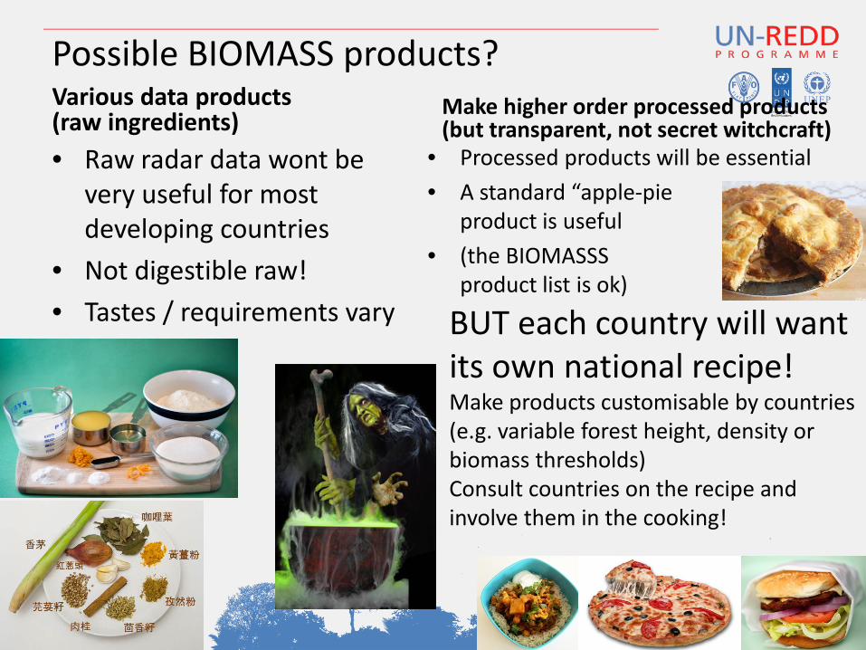
Possible BIOMASS products? Various data products (raw ingredients) • Raw radar data wont be
very useful for most developing countries
• Not digestible raw! • Tastes / requirements vary
Make higher order processed products (but transparent, not secret witchcraft)
• Processed products will be essential • A standard “apple-pie
product is useful • (the BIOMASSS
product list is ok)
24
BUT each country will want its own national recipe! Make products customisable by countries (e.g. variable forest height, density or biomass thresholds) Consult countries on the recipe and involve them in the cooking!

Make BIOMASS for national uses • For national reporting purposes, and for local use,
the BIOMASS data will need to be tailored to specific country conditions as most countries prefer to develop and use national data for reporting
• For REDD+ most countries will be aiming to develop national reporting systems – at least Tier 2 (this includes National Emission Factors, not the
defaults) and – probably Tier 3 (including spatially explicit data and analysis)
• Therefore - BIOMASS mission designers should work closely with as many developing countries as possible to develop products that are tailored and relevant to their needs
• Countries unlikely to give their plot data, will need to work jointly

26 Not to scale
For wide access, easy validation and sex-appeal, make some BIOMASS products as KML files

BIOMASS could focus on hotspots? • Obvious potential for BIOMASS to fill cloud data gaps • The importance of peat-lands
– Some peat-lands have Carbon > 1,000 t/ha – Peat-lands cover over four million km2 only 3% of land area – But they have one third of the world’s soil carbon
• Mangroves also have very high biomass – some mangroves have Carbon > 1,000 t/ha, but hard to measure – 15 million ha worldwide, but extent and change not well mapped
• These lands are carbon rich and hotspots of change • Areas are not accurately known and change monitoring weak • So could be valuable for BIOMASS to focus on them • BUT a large proportion of Carbon is below ground
– (thus BIOMASS wont see it all - so ground sampling is still necessary)
27

Total Global Emissions - Declining deforestation is one of the main success stories
Source: CDIAC; Houghton et al 2012; Giglio et al 2013; Le Quéré et al 2014; Global Carbon Budget 2014
Indonesian peat fires

29
BIOMASS Mission needs to consider 15 C’s
• Connection (poor data access)
• Cost reduction (limited funds)
• Coverage (Global, national, and hotspots, samples and wall-to-wall)
• Correlation (relate RS to ground)
• Continuity (ensure future data)
• Compatibility (understand relationships in data and results between different sensors and methods)
+ Collaboration + Co-operation + Capacity building + Communication + Confidence in results + Convincing + Cautious + Conservative
= Credibility
1. Technical challenges 2. People issues

BIOMASS mission should: My Paris Proposals (from 2009 BIOMASS meeting): • BIOMASS satellite data could be v. useful for some countries
– BUT will be difficult for many countries to access and analyse & will need assistance [still holds true]
• the BIOMASS group could provide valuable services, esp. for gaps (clouds) hotspots [still holds true]
• provide data, maps, guidelines for data collection and analysis • help other agencies set standards [not for BIOMASS team to
do, UNFCCC, IPCC have set up framework]
Develop better connections with countries: [all still to do…] • do a few pilots? cultivate a couple of country champions? • build better links with National Forest Inventories • jointly produce some practical products, outputs and tools

BIOMASS mission should: My Rome declaration / provocation! 1. BIOMASS should develop tailored products to
meet countries’ REDD+ needs 2. …work with countries to develop national
capacities and make the data used and useful 3. …need to start NOW on test data, this will take
time + effort [FAO, UNREDD, UNFCCC help] 4. …more effort needed to work with National
Governments [NFI’s, scholarships, workshops etc] 5. …collaborate with other users, especially field plot
data networks [good to see this starting]

Useful supporting materials
UN-REDD: National Forest Monitoring Systems (NFMS): – Monitoring and Measurement, Reporting and Verification
(M & MRV) in the context of REDD+ Activities
UN-REDD: Emerging Approaches to Forest Reference Emission Levels and/or Forest Reference Levels for REDD+
– presents examples of REDD+ Forest Reference Emission Levels and/or Forest Reference Levels being developed by countries
GEO – GFOI: Integrating remote-sensing and ground-based observations for estimation of emissions and removals of greenhouse gases in forests. Methods and Guidance from the Global Forest Observation Initiative
32

Thank you for your attention. More information on websites:
and www.fao.org
www.un-redd.org
http://www.unredd.net/