Wetlands Assistance Guide for Landowners
49
wetlands assistance guide for landowners t e x a s p a r k s a n d w i l d l i f e
Transcript of Wetlands Assistance Guide for Landowners

w e t l a n d sassistance guidefor landowners
t e x a s p a r k s a n d w i l d l i f e

JEFF RAASCHState Wetlands Planner
ROBERT W. SPAINHabitat Assessment
Branch Chief
LARRY D. McKINNEYResource ProtectionDivision Director
ANDREW SANSOMExecutive Director
Dear Landowner:
In the past decade or so, many landowners have viewedwetlands as a burden, an obstacle, and a problemstanding between them and the use or development of their property. Resource agencies seeking to protectwetlands have been seen as adversaries.
The purpose of this Guide is to look at the other side of the coin. For many landowners, wetland protectionhas meant increased, not decreased, property values.Indeed, growing numbers of landowners now viewwetlands as valuable assets to a broad range of landuses. Healthy riparian habitat keeps stream banks fromeroding, aids in groundwater recharge, and improvesfish and wildlife habitat. Water management and soilconservation practices nourish crops as well as wildlife,and help to keep topsoil from washing away.
In Texas, a wide variety of voluntary approaches areavailable to assist landowners in protecting wetlandsaccording to their different needs, within the context of broader conservation goals. The array of optionsincludes technical information and advice, financialcontributions for projects or practices that providelong-term improvements in wetland values, and payment at fair market rates for permanent protectionon wetland areas.
Until this Guide, there was no one place where you, the landowner, could turn for easy-to-read informationon wetlands and how you can benefit from them. TheGuide provides basic information about each assistanceoption, along with program contacts for those whodesire additional information. We hope that we havesimplified the first step that property owners can takefor help or advice on protecting, enhancing or creatingwetlands on their land.
Sincerely,

W E T L A N D S A S S I S T A N C E G U I D E F O R L A N D O W N E R S 3
About the Wetlands Assistance Guidefor Landowners 4
Texas Wetlands – A VanishingResource
What is a Wetland? 4Texas Wetland Types 5Wetlands Loss 8Why are Wetlands Important? 8
Roles of Federal and State Agencies inWetlands 10
Wetlands Conservation InitiativesTexas Wetlands Conservation Plan 12Lone Star Land Steward Awards 12Land Trusts Offer Long Term
Land Protection 12Texas Wetlands Grants Database 13Wetlands Project Site Registry 13Facts and Fiction: Conservation
Wetlands on Private Lands 13
The Decision Tree: Choosing the Best Option or Options for theLandowner 15
General Landowner OptionsConservation Easements 16Leases 16Management Agreements 16Mutual Covenants 16Wildlife Management Associations and
Co-operatives 16Qualification of Agricultural Land in
Wildlife Management Use 17Restoration 17Limited Development Strategies 17Remainder Interests 17
Transfer of Development Rights 17Sale Option 18Donation of Land 18
Sources of AssistancePrograms and Land Characteristics:
A Quick Reference Guide 19
Non-Regulatory Federal ProgramsChallenge Cost Share 20Conservation Contract 20Conservation Reserve 20East Texas Wetlands 21Environmental Quality Incentives 21Forestry Incentives 22Forest Stewardship 22North American Wetlands Conservation
Act of 1989 22North American Waterfowl Management
Plan Joint Venture Projects 23• Gulf Coast 24• Lower Mississippi Valley 24• Playa Lakes 24
Partners for Fish and Wildlife 25Texas Prairie Wetlands Project 25Wetlands Reserve 26Wildlife Habitat Incentives 27
Non-Regulatory State ProgramsForested Wetlands Incentive 28Landowner Incentive 28MARSH Program 29Private Lands and Habitat 29Private Lands Initiative 29Wetland Habitat Alliance of Texas 30Summary Table: Federal Programs
Providing Economic and Other Incentives for Wetlands Protection 30
Summary Table: State Programs Providing Economic and Other Incentives for Wetlands Protection 33
Federal Regulations 34
State Regulations 39
AppendicesAppendix I–Programs and Contacts 41Appendix II–Federal and State
Offices 43Appendix III–Wetlands Education
Assistance 45
C O N T E N T S
The eastern wild turkey and the American alligator are among the manyanimals that depend on Texas’ inland and coastal wetlands for their survival.©TPW
ACKNOWLEDGEMENTS
We are grateful to the many
people who, throughout the
course of preparing this guide,
gave generously of their time
and experience in answering
questions, providing
information and photographs,
and reviewing drafts.
For copies of A Wetlands
Assistance Guide for
Landowners, or more
information about the Texas
Wetlands Conservation Plan,
contact the Texas Wetlands
Conservation Program,
Resource Protection Division,
Texas Parks and Wildlife,
4200 Smith School Road,
Austin, TX 78744, Phone:
(512) 389-4328, FAX:
(512) 389-8059. Visit Texas
Parks and Wildlife’s Web
site for more information
on wetlands at:
www.tpwd.state.tx.us

4 W E T L A N D S A S S I S T A N C E G U I D E F O R L A N D O W N E R S
What is a Wetland?
To know what to protect, we must firstknow what a wetland is. Wetlands areamong the most important ecosystems onearth. They not only provide numerousproducts for human use and consumption,including fossil fuels and food, but areinvaluable as the “kidneys of the land-scape” for their ability to purify pollutedrivers, prevent and minimize flooding,protect shorelines, and replenish ground-water sources. Wetlands also provide valu-able habitat to numerous species ofwaterfowl and wildlife.
But what is a wetland? Wetlands aredefined by the State of Texas as areas
“including swamp, marsh, bog, prairie pot-hole, or similar area, having a predomi-nance of hydric soils that are inundated orsaturated by surface or groundwater at afrequency and duration sufficient to sup-port, and that under normal circumstancesdo support, the growth and regenerationof hydrophytic vegetation.” Simply stated,wetlands contain (1) water or saturatedsoils for at least part of the year, (2)plants that have adapted to life in wetenvironments (hydrophytic vegetation),and (3) special soils that develop underdepleted oxygen conditions (hydric soils).
Wetlands can be swamps, bottomlandhardwoods, marshes, bogs, springs,resacas, playa lakes, and saline (alkaline)
The State recognizes that private landown-ers are stewards of a natural resource inwhich many of the benefits are accrued tothe public. Ninety-seven percent of Texas’land is privately owned and managed, andas such, management decisions on theselands are made by private landowners.Because economics often dictate whatthese management strategies will be, theWetlands Assistance Guide for Landownerswas developed as a comprehensive guideto federal, state, and private programsoffering technical and/or financial assis-tance to private wetland owners withinthe State of Texas. The programs aredesigned to enhance, create, and conservewetlands in Texas in exchange for techni-cal, financial, and educational assistance toprivate landowners. Each program descrip-tion contains: (1) a brief summary of theprogram, its goals, funding, the processnecessary to participate, and benefits tothe landowner; and (2) eligibility require-ments. Through the information offered inthis Guide, Texas landowners will be able
to make informed decisions on how tomanage their wetlands with the aid offinancial incentives such as cost-sharing orrental payments. Landowners can locateprograms best suited to their needs. Othersections of the Guide include a summaryof what wetlands are and why they areimportant, agency roles and contacts, clarification of existing regulations affect-ing wetlands, and various tables for quickreference.
About the Wetlands AssistanceGuide for Landowners
Bald cypress trees in Caddo Lake.©TPW
Bald CypressTaxodium distichum(freshwater swamps andriparian areas in Centraland East Texas)
Drawing from Trees of East Texasby Robert A. Vines
Texas Wetlands — A Vanishing Resource
Wetlands are one of Texas’ most valuable natural resources. Bottom-land hardwoods, riparian corridors,coastal wetlands, and playa lakes arevital to maintaining our unequaledfish and wildlife resources. Wetlandsprovide f lood protection, improvewater quality and provide the basis for other economic benefits totaling billions of dollars nationwide eachyear.
Estimates reveal that Texas haslost over half of its original wetlands.Much of this loss has been in responseto meeting our needs for food, fiber,housing, industrial, and reservoirdevelopment – all of which are vital tomaintaining the economic health ofTexas. If we are to assure that sameeconomic vitality and quality of life for future Texans, we must worktogether now to conserve our remain-ing wetlands, which are an importantnatural and economic resource.

transitional areas often meet the defini-tion of wetlands. Another drop in land-scape position and species diversity isreduced even more. Lower areas that pondor flood for long durations typically sup-port water tolerant species in monocul-tures of overcup oak, red maple, water elm(planar tree), or bald cypress dependingon site conditions. Bottomland hardwoodforest ecosystems contain a great varietyof trees, shrubs and vines that growtogether in different vegetation assem-blages depending on soil type, waterdepth, velocity, and flood duration inTexas. Bottomland hardwoods supportover 180 species of trees. Characteristicherbaceous species include sedges, arrow-heads, smartweed, spider lilies, and blad-derwort. Common animals found in theseforests include waterfowl, eastern wildturkey, swamp rabbit, furbearers, and grayand fox squirrels.
Conversion of f loodplain forests toother land uses places bottomland hard-wood forests ecosystems among the mostseverely altered ecosystems in the UnitedStates. Loss of these forests has beencaused by many activities, including watercontrol structures, agriculture, logging,mining, petroleum extraction, develop-ment, and pollution.
The Gulf coast contains a diversityof saline, brackish, intermediate andfresh marsh wetlands, including wetprairies, forested wetlands, barrier islands,
lakes. Wetlands are found along rivers,streams, lakes and ponds; in uplanddepressions where surface water collects;and at points of groundwater dischargesuch as springs or seeps. They are foundin both saltwater and freshwater systems,on every continent except Antarctica, andin every climate from the tropics to thetundra. As their name indicates, they are“wet land,” since they are located in thetransition zone between upland and openwater. Both aquatic and upland plant andanimal species may therefore depend onwetlands for their survival.
Texas Wetland Types
What kinds of wetlands do we have inTexas? In this state, the different regionalclimates result in regional differences inwetland types. While different types ofwetlands are found statewide, thosedescribed below are some of the morecommon wetlands in Texas.
East Texas is dominated by bottom-land hardwood forest ecosystems.These forests are characterized bybroad-leaved (e.g., oak, elm, ash) and needle-leaved (e.g., cypress) deciduous
W E T L A N D S A S S I S T A N C E G U I D E F O R L A N D O W N E R S 5
plants that typically grow in creek andriver f loodplains. Not all bottomland hard-woods meet the wetland definition, how-ever. Ridges, mounds, and terraces withinthe bottomland hardwood ecosystem areoften located at a landscape position toohigh to remain flooded, ponded, or satu-rated long enough to meet wetland crite-ria. These areas typically support a verydiverse forest with a mix of cherrybarkoak, swamp chestnut oak, Shumard oak,water oak, sweetgum, sweet pecan, Ameri-can elm, eastern red cedar and loblollypine. A slight drop in landscape positionwill result in changes in species diversity,as those species intolerant of long-termwetness are lost. Typically these areas sup-port willow oak, laurel oak, green ash, andcedar elm. Often the species compositionis dominated by one or two species. These
Three parameters are used todefine wetlands: hydrology,
soils and vegetation.©Jack Bauer
Conversion of f loodplain forests to other land uses places bottomland hardwoodforests among the most severely altered ecosystems in the United States.©TPW
Pitcher plants in an East Texas bog.©TPW
6 W E T L A N D S A S S I S T A N C E G U I D E F O R L A N D O W N E R S
mud flats, estuarine bays, bayous andrivers. Saline and brackish marshes aremost widely distributed south of theGalveston Bay, while intermediate andfresh marshes are the most extensivemarsh type east of Galveston Bay. Theexistence and extent of specific plantspecies within these different wetlandtypes depends on their specific tolerancesto salt concentrations and variability inwater depth. Some overlap of species canbe found within the different wetlandtypes on the Gulf Coast.
Along the Texas coast as you transi-tion from open water to marsh habitatseveral important habitats lie in between.Seagrass beds are submerged wetlandsthat are inundated a majority of the timeby seawater. These beds are vegetated by anumber of grass-like plant species, whichcan tolerate short-term aerial exposure butgenerally prefer prolonged/permanentshallow inundation. These areas areextremely important in the life cycle manymarine species. Tidal/mud flats are unveg-etated mud or sandy sediments, which arealternately f looded and exposed with thechanging tides. In some cases these areascan become covered in algae and are thenconsidered “algal f lats.” These areas pro-vide important foraging areas to manyspecies of shorebirds.
Saline marshes are wetlands areasdominated by the influence of fullstrength or near full-strength seawater andtidal action along the Texas coast. Seawa-ter has a salinity of 36 grams (g) of salt/L
of H2O. Salt and flood tolerant grasses andherbs are the predominant plant species insaline marshes such as smooth cordgrass,blackrush, saline marsh aster, saltwort,glasswort, and sea-lavender. Brackishmarsh (mesohaline) communities, the mostextensive communities in the GalvestonBay system, are transitional betweensaline and intermediate marshes and aretidal wetlands subject to salinities gener-ally between 5 and 20-25 g/L. Areas arevegetated with grasses and herbs capableof tolerating variable salinity and floodingconditions such as marshhay cordgrass,saltgrass, saltmarsh bulrush, marsh hempand hairypod cowpea.
Intermediate marshes (oligohaline)reflect greater plant diversity than thesaline or brackish marsh assemblages andare tidal wetlands subject to salinitiesbetween 0.5 and 5 g/L. Areas are vege-tated by flood tolerant grass and herbspecies, which are also capable of tolerat-ing some variability in salinity. Some ofthese plants include seashore paspalum,marshhay cordgrass, Olney bulrush, Colorado River hemp, common reedgrass,coastal water-hyssop, bearded sprangletop,and cattail. Fresh marshes support thegreatest diversity in plant species of allmarsh types and are tidal or non-tidal wetlands subject to salinities of less than0.5 g/L. Dominant vegetation include giant cutgrass, American lotus, whitewater-lily, smartweed, marsh millet, arrow-head, seedbox, cattail, alligator weed, andmany others.
The brown pelican and the whooping craneare two federally listed endangered species thatbenefit from wetlands enhancement programs.
©TPW
SpiderlilyHymenocallis spp.(organic waters ofmarshes and muddystream margins)
Drawing courtesyof North CarolinaAgriculturalResearch Service
Coastal wetlands in Texas provide one of the mostimportant wintering and migration areas in NorthAmerica for waterfowl using the Central andMississippi f lyways.

W E T L A N D S A S S I S T A N C E G U I D E F O R L A N D O W N E R S 7
South Texas freshwater or brackishwetlands include small, isolated depres-sions and resacas (or oxbows), which arerelic meanders of the Rio Grande River.Coastal depressions were formed whenclay soils exposed by wind action trap andhold water, often supply the only freshwater for resident wildlife in an area gen-erally devoid of creeks and rivers. Inter-dunal swales are depressional wetlandslocated in between beach dunes along thecoastline. Areas can range in salinity fromfresh to saline depending on time of year,proximity to the coastline, storm events,etc. Vegetation is usually dominated bybrackish to fresh grasses and other herba-ceous species. Mangrove swamps are salinewetlands located in far south Texas thatare dominated by salt and tidally adaptedtree species (mangroves). These wetlandsreplace salt marshes as the dominantcoastal wetland type in tidal saline envi-ronments as climates transition from tem-perate to sub-tropical and tropical latitudes(i.e., as you move toward the equator).
In far southeast Texas, large clay flatsmeet the wetland definition due to veryhigh rainfall averages (50-55 inches/year),f lat topography, and clayey soils. Thesewet prairie wetland systems are seldomponded but for a few days and remain sat-urated throughout much of the late winterand early spring. Many of these areas areused for rice production and are valuablewaterfowl habitat. When not farmed theseareas support herbaceous wetland plantssuch as f latsedge, annual sumpweed,smartweed, switchgrass, broomsedgebluestem, and rattlebox. If not controlled,the highly invasive exotic tree, Chinesetallow, will completely dominate many ofthese areas, converting these valuable his-
toric prairie wetlands to scrub/shrub wet-land with little or no understory.
Coastal wetlands in Texas provide oneof the most important wintering andmigration areas in North America forwaterfowl using the Central and Missis-sippi f lyways. The bald eagle, peregrinefalcon, brown pelican, and whooping craneall depend on the marshes and estuariesfor food, as do otter, alligator and swamprabbit.
Coastal development poses a severethreat to coastal wetlands through conver-sion to other habitats, saltwater intrusion,subsidence, groundwater withdrawal, ero-sion, sedimentation, decreased water qual-ity and impacts to wildlife and waterfowl.
The High Plains and RollingPlains of the Panhandle support wet-lands predominantly in playa lakes andsaline lakes (High Plains), and inwater-table influenced basins and ripar-ian habitats (Rolling Plains). Playas areephemeral wetlands characterized by Ran-dall or Ness clay soils, and are very simi-lar to potholes, but have a differentgeologic origin. Saline lakes are generallylarger than playas, are very saline, and areinfluenced by groundwater. A few playasand playa-like basins with connec-tions to groundwater occur in theRolling Plains. Riparian wetlandsinclude main channels of creeks andrivers and associated wet meadow,bog and beaver pond habitats.
The playa lakes region of theUnited States includes portions ofColorado, Kansas, New Mexico, Oklahoma, and northwestern Texas.Texas alone has over 19,000 playas.Playas are the wintering and breed-ing area for several million ducks,
geese and other migratory birds. Severalthreatened and endangered species usewetland habitat in the playa lakes region,including the bald eagle. Many neotropicalmigrant birds use playas as well, includingthe long-billed curlew, American avocet,killdeer, Mississippi kite, mountain plover,lark bunting, and American kestrel.Because playa lakes are fed by rainwater,many may be dry for extended periods oftime. The 86 plant species living in playashave adapted to this unpredictable, rapidlychanging environment. The most commonplants found in the playa lakes includespikerush, curly dock, bulrush, cattail, pinkand willow smartweed, pondweed, wol-lyleaf bursage, and barnyard grass. Woodyspecies in riparian habitats include Plainscottonwood, buttonbush, net-leaf hack-berry, native plum, western dogwood, andpersimmon.
Few playa lakes have escaped alter-ation by humans. Many have been alteredfor irrigation, grazing, and cropping pur-poses. Many other playas provide impor-tant wetland habitat for Panhandle wildlifeincluding pheasants, shorebirds, sandhillcranes and waterfowl.
Colorado
The Playa Lakes Region
Texas
Oklahoma
Kansas
NewMexico
Many playas provide importantwetland habitat for Panhandle wildlifeincluding pheasants, shorebirds,sandhill cranes, and waterfowl.
Most playa lakes, found inthe High Plains of thePanhandle, have been
altered by mankind.©TPW

8 W E T L A N D S A S S I S T A N C E G U I D E F O R L A N D O W N E R S
Wetlands LossHistorically, wetlands were not widely rec-ognized as valuable or appreciated. In fact,wetlands were often regarded as “waste-lands” and breeding grounds for insects,pests and disease, and were consideredimpediments to development and progress.As a result of this reputation, wetlandswere readily converted to other land uses.
According to a 1997 survey performedby the U.S. Fish and Wildlife Service,approximately 392 million acres of wet-lands existed in 1780 in lands that nowform the United States. Of that, 221 mil-lion acres were found in the lower 48states. Since that time, humankind hascaused a significant reduction in wetlands.Currently, the lower 48 states support onlyan estimated 100.9 million acres, or 46%of the original wetland acreage. It appears,though, that wetlands losses have slowedto a rate 60% below that experienced inthe 1970s and 1980s. Net losses from1985-1995 totaled 117,000 acres per year,much of which occurred in highly produc-tive freshwater forested wetlands. Much ofthose losses can be attributed to continuedconstruction of reservoirs in eastern Texasas many acres of bottomland hardwoodforests have been covered by water.
Factors contributing to this decline inthe loss rate include increased publicawareness and support for conservation,expansion of public and private-sectorrestoration programs, enactment of Swamp-buster measures in the Farm Bill since
1985, Clean Water Act Section 404 imple-mentation, and a decline in convertingwetlands due to the tax reform of 1986.
Texas, has lost significant quantitiesof wetlands, having experienced an esti-mated fifty-four percent loss in the past200 years. While wetland losses haveresulted from a number of actions, theprincipal ones are: filling, draining, exca-vating, diverting, clearing, f looding, shad-ing, adverse impacts from adjacent landuses, grazing, farming, and others.
Why are Wetlands Important?Wetlands provide a variety of ecologicalfunctions both to the natural ecosystemand to humans that are now widely recog-nized as beneficial. Functions that are use-ful to humankind are called “values.”These values are typically regulated under
legislation such as the Clean Water Act.Some values provided by wetlands include:
•flood control•erosion control•removal of sediment and toxicants•removal or transformation of
nutrients•groundwater recharge or discharge•fish and wildlife habitat•natural area buffers•outdoor recreation/education•commercial uses (e.g., shellfishing or
timber).Not all wetlands provide all functions
and values, and each wetland is unique.Several of these values are particularlyimportant in Texas.
Flood ControlRivers, streams and other wetlands formnatural f loodplain systems that play aninvaluable role in offsetting flood damage
Urbanization is a major cause of wetlands loss in the United States.©TPW
Wetlands vegetation is important to prevent erosion problems.©Texas Dept. of Agriculture

W E T L A N D S A S S I S T A N C E G U I D E F O R L A N D O W N E R S 9
by regulating and maintaining the hydrol-ogy in rivers and streams during floodevents. The dense wetland vegetationreduces the velocity of f loodwaters thattravel through the system, which allowswater to percolate into and be stored inthe underlying soils. Over time, the flood-waters are slowly released back into theriver or stream, the atmosphere and thegroundwater. By reducing the rate andamount of storm water entering the riveror stream, wetlands lessen the destructive-ness of the flood. In Wisconsin, a studydemonstrated that a watershed composedof at least 30% wetlands could reducefloodwater levels by 60-80% compared towatersheds containing no wetlands.
Erosion Control Erosion of soils can be caused by increasesin water velocities from upstream con-struction sites, unvegetated ground or agricultural fields. Wetland vegetation pro-vides an important buffer to adjacentwaterbodies by filtering and holding sedi-ments that would otherwise enter lakesand streams and eventually fill them.
Reduction of Water PollutionWetlands absorb and filter a variety ofsediments, nutrients and other natural andmanmade pollutants that would otherwisedegrade rivers, streams, and lakes. Water
flowing from uplands into water bodiesoften passes through wetlands, whichmaintain and improve water quality by fil-tering out nutrients and sediments beforethey reach the river or stream. Wetlandslessen the effects of nonpoint sourcerunoff into water bodies by reducing flowvelocities and by acting as a sediment,nutrient and heavy metal trap. One studyfound that nitrogen and phosphorus reten-tion in riparian forests were 89% and80%, respectively, compared to 8% and40% in cropland. Additionally, forestedareas adjacent to rivers lower the watertemperature in hot summer months, whichreduces undesirable algal blooms thatdecrease water quality and can kill aquaticorganisms. In estuaries, sediment canharm filter feeders such as oysters andalso impedes sight-dependent feeders suchas trout.
Wildlife Habitat Wetlands provide essential nesting, migra-tory and wintering areas for more than50% of the country’s migratory birdspecies. Texas is one of the most impor-tant waterfowl wintering areas in the Central Flyway, and provides habitat for3-5 million birds each year. Wetlands pro-vide habitat for one-third of the federallylisted endangered and threatened plantand animal species. Additional benefits
include supplying important nursery andspawning habitat for 60-90% of the com-mercial fish species.
RecreationMany recreational activities take place inand around wetlands. Popular recreationalactivities include hiking, waterfowl hunt-ing, fishing, nature observation and canoe-ing. Wetlands provide a multi-billiondollar fishing, hunting, and outdoor recre-ation industry nationwide.
The Difference between Wetlands Creation, Enhancement, and Restoration • Wetland restoration is defined as the
rehabilitation of a degraded wetland orhydric soil area that was previously anaturally functioning wetland.
• Wetland enhancement is defined asimprovement, maintenance, and man-agement of existing wetlands for a par-ticular function or value, possibly at theexpense of others.
• Wetland creation is defined as the con-version of a non-wetland area into awetland where a wetland never existed.
• Constructed wetlands are specificallydesigned to treat both non-point andpoint sources of water pollution.
Private landowners have protected thousands ofwetlands for recreation, including hunting and fishing.
©TPW

1 0 W E T L A N D S A S S I S T A N C E G U I D E F O R L A N D O W N E R S
Roles of Federal and State Agencies in WetlandsMany government agencies within Texasare involved in varying aspects of wetlandmanagement, regulation, and technical andfinancial assistance. Appendix II listsagency addresses and phone numbers ifyou would like additional information.
Texas Agricultural Extension Service(TAEX), a part of the Texas A&M Univer-sity System, educates Texans in the areasof agriculture, environmental stewardship,youth, and adult life skills, human capitaland leadership, and community economicdevelopment. Two of the four strategicgoals of the Extension Service relate to theenvironment: (1) educate citizens toimprove their stewardship of the environ-ment and Texas natural resources throughits network of educators in county offices.In addition to other responsibilities,county agents provide technical assistance
in habitat management to landowners; and(2) foster the development of responsible,productive and self-motivated youth andadults. TAEX provides wetlands informa-tion to landowners and has organized sev-eral educational programs for children.
Texas Forest Service (TFS) is involvedin wetlands primarily in an advisorycapacity to private landowners. The TFSprovides management assistance to ownersof forest lands, many of which are in wet-land areas. Present policies accept orencourage timber harvest in wetlands.
Texas General Land Office (GLO) is thestate agency responsible for the manage-ment of state-owned public lands notspecifically purchased by or deeded toother agencies. These lands include coastalwetlands inland to the line of mean hightide and up rivers to the limit of tidalinfluence. The GLO is a proprietary andnot a regulatory state agency. Users ofstate-owned lands obtain leases or ease-ments and pay a fee for mineral extraction,occupancy, or encumbrance of public lands.The GLO is also the state’s lead agency forcoordinating the Coastal Management Plandesigned to preserve public beach access,protect coastal wetlands and other coastalnatural resources, and respond to beacherosion along the Texas coast.
Texas Natural Resources ConservationCommission (TNRCC) implements manysections of the Texas Water Code and thefederal Clean Water Act and Safe DrinkingWater Act. The TNRCC develops waterquality requirements designed to protectattainable uses and to maintain the qual-ity of waters in the state. These standardsare the basis for permits issued by theTNRCC authorizing discharges into or nextto waters in the state. TNRCC also reviewsapplications for Clean Water Act Section404 permits, which require a state waterquality certification under Section 401 ofthe Clean Water Act. TNRCC administerswastewater and water rights permit andenforcement programs.
Texas Hill Country stream.©Jack Bauer
SmartweedPolygonum spp.(found in freshwater,fruits provide excellentwaterfowl forage)
Drawing courtesyof North CarolinaAgriculturalResearch Service
Cypress swamp in East Texas.©TPW

W E T L A N D S A S S I S T A N C E G U I D E F O R L A N D O W N E R S 1 1
Texas Parks and Wildlife (TPW) has primary responsibility for protecting thestate’s fish and wildlife resources. TPWacquires, manages, and protects wildlifeand its habitat, and acquires and managespark lands and historic areas.
TPW has numerous programs to protect or manage wetlands. The agencycoordinated development of the Texas Wet-lands Conservation Plan. In addition, thestate park system, which provides attrac-tive and educational areas for public recre-ation, also features many aquatic andwetland habitats. Master plans are pre-pared for each park prior to developmentto ensure that important natural areassuch as wetlands are protected.
TPW has acquired lands in virtuallyevery part of the state for the conserva-tion, management, and study of wildlifespecies. Wildlife management areas typi-cally include wetlands and open water foruse by resident and migratory wildlife.Wildlife management areas specificallymanaged for waterfowl have been pur-chased with federal funding and by fundsgenerated by the state waterfowl stamprequired of all waterfowl hunters. In addi-tion, TPW conducts research to help deter-mine management practices for waters andwetlands necessary to promote and sustainfisheries.
Texas Soil and Water ConservationBoard (TSWCB), working in conjunctionwith Texas’ 216 soil and water conserva-tion districts, encourages the wise and pro-ductive use of the state’s soil and waterresources through technical assistance pro-grams and conservation activities. TheState Board is the lead agency responsiblefor planning and management of nonpointsource pollution control relating to agricul-ture and silviculture. Field staff locatedthrough the state consult with local soiland water districts and landowners toensure that appropriate land and waterconservation methods are applied.
Texas Water Development Board(TWDB) administers state and federalfinancing programs for water-related proj-ects, and forecasts and plans for long-termwater needs with associated data collect-ing and resource studies. The Board pre-pares the State Water Plan, which outlinescurrent and future needs for water andwastewater treatment projects in Texas for
the next fifty years. In response to increas-ing competition for water, escalating infra-structure costs and statewide droughtconditions, the 75th Texas Legislaturepassed Senate Bill 1, the Brown-LewisWater Plan. Senate Bill 1 directs 16Regional Water Planning Groups (RWPGs)to plan for a region’s 30 and 50 yearwater needs by identifying the most costeffective and environmentally sound watermanagement strategies. The TWDB willdevelop a statewide water plan using theregional plans.
United States Army Corps of Engineers(Corps) provides design and engineeringservices and construction support for avariety of military and civilian projectsworldwide. One civil duty includes protect-ing the integrity of the navigable waters ofthe United States, wetland resources, andthe nation’s water resources. These respon-sibilities are carried out through theissuance or denial of Clean Water Act Sec-tion 404 and other permits authorizingcertain activities in wetlands and otherwaters of the United States. The Corps’duties also include maintaining navigationand shipping channels, providing emer-gency response to natural disasters, regu-lating discharges of dredged or fillmaterial, operating and maintaining floodcontrol reservoirs, and regulating activitiesin wetlands.
United States Environmental ProtectionAgency (EPA) is responsible for imple-menting federal laws designed to protectthe nation’s natural resources. This isdone primarily through regulation, butEPA has also developed a wide varietyof funding, planning, and educationprograms. EPA has the authority toregulate wetlands under Section 404of the Clean Water Act. The EPA offers a Wetlands Protection Hotline thatresponds to questions and provides mate-rials on a variety of wetlands topics. TheHotline can be reached Monday throughFriday from 9:00 am to 5:30 pm EST, at(800) 832-7828.
United States Fish and Wildlife Service(USFWS) is the principal federal agencyresponsible for conserving, protecting andenhancing certain fish and wildlife andtheir habitats, in particular migratoryspecies, including waterfowl, shorebirds
and songbirds, and federally listed threat-ened and endangered species. Among otherroles, the Fish and Wildlife Service admin-isters the federal Endangered Species Actand establishes and maintains a system ofover 500 National Wildlife Refuges nation-wide. The USFWS also manages the takingof migratory waterfowl and conductsresearch and monitoring programs toinventory and record changes in popula-tions of fish and wildlife and in habitats.
USDA Farm Service Agency (FSA) is abranch of the U.S. Department of Agricul-ture formed to administer commodityprice and income support programs, farmoperating loans, the federal crop insuranceprogram and conservation cost-share pro-grams. The agency was formed from all orpart of three other agencies – the ASCS,the Farmers Home Administration, and theFederal Crop Insurance Corporation.
USDA Natural Resources ConservationService (NRCS) provides technical andfinancial assistance to landowners in devel-opment and implementation of resourcemanagement systems that conserve soil,air, water, plant and animal resources. Thisagency employs soil scientists, plant scien-tists and engineers that can provide assis-tance in identifying, restoring, enhancingand creating wetlands. The NRCS is thelead agency for identifying and delineatingwetlands on both grazing and agriculturallands in the U.S.
Overcup OakQuercus lyrata(found on wet, poorlydrained clay soils alongrivers in East Texas)
Drawing from Trees of East Texasby Robert A. Vines

The Texas Wetlands Conservation PlanThis Assistance Guide is one component ofthe Texas Wetlands Conservation Plan(SWCP). Texas Parks and Wildlife, in astatewide cooperative effort, completedthe Texas Wetlands Conservation Plan in1997. The Plan focuses on non-regulatory,voluntary approaches to conserving Texas’wetlands. Its contributions to wetlandsconservation include:
• Enhancing landowner’s access tonew and existing incentive pro-grams and other land use optionsthrough outreach and assistance;
• Developing and encouraging landmanagement options that providean economic incentive for conserv-ing existing wetlands or restoringformer ones; and,
• Coordinating regional wetlands con-servation efforts.
Over the course of a year (1995-1996), three Regional Advisory Groups(East Texas, the coast and the Panhandle)periodically met to identify regional andstatewide issues associated with conserv-ing Texas wetlands. Through these meet-ings, landowners and representatives fromagriculture, industry, business, conserva-tion, and government developed recom-mendations and proposals for action toaddress the identified wetland issues.These results form the core of the TexasWetlands Conservation Plan. The TexasParks and Wildlife Commission approved aresolution on April 17, 1997 supportingthe Texas Wetlands Conservation Plan andthe Governor signed it in July 1997.
Numerous implementation efforts areunderway related to wetlands conservation
and education on private lands, includingthe Wetlands Project Site Registry, theForested Wetlands Incentive Program, anda variety of technical publications. If youwould like more information about thePlan or would like to receive the newslet-ter feel free to contact Jeff Raasch, StateWetlands Planner, Texas Parks andWildlife, 4200 Smith School Rd., Austin,TX 78744, (512) 389-4328 [email protected].
Lone Star Land Steward AwardsSince 1995, Texas Parks and Wildlife hasrecognized and honored private landown-ers for their accomplishments in habitatmanagement and wildlife conservationthrough the Lone Star Land StewardAwards. The program, now in its fourthyear, recognizes landowners in all habitattypes within the 10 ecological areas ofTexas, from timberlands to native prairiesand from marshes to mountain ranges.One landowner is recognized from each ofthe ten ecological regions. In addition, awildlife management association, and acorporation or foundation are recognizedin two special categories.
Landowner participation in existingincentives programs (e.g. Private Lands Ini-tiative, Wetland Reserve Program) is onepositive way of demonstrating commit-ment to wildlife conservation. Most of thegoals of the incentive programs are consis-tent with those set forth in the Lone StarLand Steward Awards Program.
The objectives of the Lone Star LandSteward Awards Program are to:
• Recognize private landowners forexcellence in habitat management
and wildlife conservation on theirlands.
• Publicize the best examples ofsound natural resource manage-ment practices.
• Encourage the education and partic-ipation of youth in promotingresponsible habitat managementand improved ecosystem health.
• Promote long-term conservation ofunique natural and culturalresources.
• Promote ecosystem awareness andacknowledge the best conservationpractices in the state’s 10 ecosystems.
• Improve relationships between pri-vate landowners and Texas’ naturalresource agencies; and to
• Illustrate the important role ofTexas’ private landowners in thefuture of our natural resources.
Winners are honored at a specialreception hosted by the Texas Parks andWildlife Commission and the Private LandsAdvisory Board each spring. Onelandowner will be honored as thestatewide Lone Star Land Steward.
Landowners may apply or be nomi-nated by any individual or organization.Ranchers, farmers, foresters, and other landmanagers and cooperatives may participate.
Applications for nominations areavailable at TPW, Private Lands and Habi-tat Program, 4200 Smith School Road,Austin, Texas 78744, or call1-800-792-1112 or (512) 389-4407.
Land Trusts Offer LongTerm Land ProtectionA land trust is a local, regional or nationalnonprofit organization that protects landfor its natural, recreational, scenic or pro-ductive value. Land trusts have varyingconservation objectives; some work in spe-cific geographic areas or concentrate onprotecting different natural or cultural fea-tures. Generally, land trusts manage pur-chased or donated land and easements forconservation purposes. Currently, morethan 34 land trust organizations operatein Texas. For information on Texas’ landtrusts, please contact Carolyn Scheffer,Texas Parks and Wildlife, (512) 389-4779or [email protected].
1 2 W E T L A N D S A S S I S T A N C E G U I D E F O R L A N D O W N E R S
Wetland Conservation Initiatives in Texas
Private landowners play acritical role in conservingwildlife habitat in Texas.
©Texas Dept. of Agriculture

The Texas Wetlands Grants Database The Wetlands Grants Database is a search-able compilation of more than 165 federal,state and private assistance programsavailable to Texans to fund wetlandrestoration, research, program develop-ment and education. The Texas WetlandsGrants database is intended to assist citi-zens in initiating a search for wetlandsproject funding. Both specific grant pro-grams and other database connectionshave been provided to assist funding seek-ers in expanding their search on theirown. This database will be available onTPW’s Web site by the Fall of 2000. Keepan eye out for it at www.tpwd.state.tx.us.If you have questions please contact JeffRaasch at [email protected].
Wetlands Project Site RegistryAlthough many incentive programs arecurrently available, the Texas WetlandsConservation Plan indicated the need foradditional non-regulatory conservationprograms geared toward private landown-ers. As a result, the Wetlands Project SiteRegistry was developed, which joins inter-ested landowners with those who arerequired to mitigate for wetlands lost dur-ing the process of development. The Reg-istry is intended to help those Texaslandowners already interested in wetlandsrestoration achieve their goals whilegreatly increasing the quantity and diver-sity of landscapes from which the best mit-igation sites may be selected.
The Wetlands Project Site Registry is avoluntary, non-regulatory alternative forpublic and private landowners desiringwetlands conservation on their property.Like “want ads,” the Registry functions tolink those who need or want to restorewetlands with interested property owners.The Registry consists of an Internet acces-sible database of public and private sitesthat are available for wetlands restorationthroughout Texas. Landowners can use theRegistry to describe their property, indi-cate their interest in wetlands restorationand their personal conservation goals,while agencies searching for wetlands torestore can access the database to identifypotential properties that meet their needs.
The Registry has been active on TexasParks and Wildlife’s Internet site sinceAugust, 1998. Currently, the Registry listsover 41,000 acres of wetlands and wetlandassociated uplands available for conserva-tion on the properties of over 100 privatelandowners throughout the state. A data-base of over sixty wetland projects avail-able on public lands was added in 1999.
Public lands project descriptionsinclude contact information and a map ofthe project area; however, because of legalobligations to maintain the confidentialityof private landowners, the specific detailsof private lands sites are released onlywith the permission of the landowner.Once contact between these two partieshas been established, the process of devel-oping a mitigation plan will continue as itdoes currently. Landowners who agree tohave mitigation sites on their propertyretain ownership, the right to restrictaccess, and may arrange mutually-benefi-cial financial agreements with a developer;however, landowners must be aware thatcertain restrictions on land use may applybased upon the terms negotiated in a per-manent easement.
The Registry is available on-linethrough Texas Parks and Wildlife’s home-page at www.tpwd.state.tx.us. If you havequestions about the Registry, please contactJennifer Key at [email protected] (512) 389-8521.
Facts and Fiction: Wetlands Conservation on Private LandsThroughout Texas, many landowners areinterested in habitat conservation on theirproperty. However, two common concernsprevent them from restoring or enhancinghabitat: fear of any ensuing regulationsand a lack of funds to defray restorationcosts. The Regional Advisory Groupsagreed that obstacles to wetlands conserva-tion on private lands could best be over-come by offering landowners incentives toconserve their wetlands. Incentives, ratherthan regulations, foster pride and landstewardship since landowners are inte-grally involved in decision-making andplanning throughout the duration of theproject.
The elimination of disincentives towetland conservation would encouragelandowners to consider initiating conserva-tion activities on their property. Whilesome disincentives do exist that may limitcertain activities in wetlands, many aremisperceptions; in other words, they aresimply untrue or have limited application.As a general rule, incentive programs donot prohibit common land use practices(e.g., grazing, hunting); however, thoseactivities may be managed to preventadverse impacts to the wetland project.
Most economic incentives to landown-ers are offered through specific wetlandsprograms. Because wetlands incentive pro-grams are voluntary, landowners assist indetermining the terms of their own con-servation agreement. Each program offersdifferent incentives; therefore, landownersshould select a program that best suitstheir individual needs and interests.
Some of the most common perceived disin-centives to wetland conservation include:
PERCEPTION 1: “Creating, restoring orenhancing wetlands subjects landownersto wetlands regulations.”
FACT: Several scenarios exist forlandowners that have created,restored or enhanced wetlands:1) Created, restored or enhanced wetlands that are maintained as partof an ongoing agricultural operationare exempt from Clean Water Act regulations.2) Agricultural fields f looded duringthe winter for waterfowl will not beimpacted by Clean Water Act regula-tions unless discharges of dredged orfill material occur.3) Landowners who enhance, restoreor create non-tidal wetlands but whothink they may later want to returnthem to their condition prior to theconservation activity can, with someadvanced planning, be authorized todo so under Clean Water Act Nation-wide Permit 27. This permit author-izes reversion of restored, enhancedor created non-tidal wetlands andriparian areas back to their prior con-dition if certain conditions are met.Interested landowners should contactthe U.S. Army Corps of Engineers fordetails.
W E T L A N D S A S S I S T A N C E G U I D E F O R L A N D O W N E R S 1 3

1 4 W E T L A N D S A S S I S T A N C E G U I D E F O R L A N D O W N E R S
PERCEPTION 2: “Having or managinghabitat that encourages endangeredspecies eliminates future land useoptions.”
FACT: Landowners are responsible forexisting endangered species habitatalready present on their property.However, landowners can avoid liabil-ity for endangered species or evenspecies under consideration for listing(i.e., a candidate species), that may beattracted to any new habitat by enter-ing into a “Safe Harbor” agreement.Under this initiative, a landownerwho intends to manage habitat in away that attracts or benefits a listedspecies may enter into a cooperativeagreement with the U.S. Fish andWildlife Service or a state agency thatprotects the landowner from any addi-tional responsibility under the Endan-gered Species Act, beyond those thatexisted at the time a landownerenters into the agreement. Whilelandowners are required to protectthe habitat of any species present atthe time the agreement was signed(their baseline responsibilities), theyare under no obligation to protectadditional suitable habitat which mayhave developed or any additionalindividuals or species that may havebeen attracted by the habitat improve-ments. Landowners not participatingin a Safe Harbor or Candidate Conser-vation Agreement will be responsiblefor any new individuals residing onthe property.
PERCEPTION 3: “Hunting is not allowedunder wetland agreements.”
FACT: Habitat incentive programs generally do not restrict hunting byowners or lessees. Hunting is nor-mally limited only by federal andstate regulations.
PERCEPTION 4: “Pest treatment oncrops is regulated under wetland agreements.”
FACT: Pesticide or herbicide treatmentof adjacent cropland is generally notregulated by wetland agreements.
PERCEPTION 5: “Grazing, haying ormowing is not allowed.”
FACT: Managed grazing, haying ormowing is permitted in most situa-tions when it does not adverselyimpact the restoration project. Therequest must be made in advance andwritten into the easement.
PERCEPTION 6: “Timber harvest is notallowed.”
FACT: Limited timber removal is per-mitted in most situations when itdoes not adversely impact the restora-tion project. The request must bemade in advance and written into theeasement.
PERCEPTION 7: “My land will becomeopen to the public.”
FACT: Public access is not a conditionof wetland agreements. The incentiveprogram contact may check on theproject’s success throughout the con-tract period, but will notify thelandowner in advance.
Great Blue Heron©TPW

W E T L A N D S A S S I S T A N C E G U I D E F O R L A N D O W N E R S 1 5
ArrowheadSagittaria spp.(found in freshwatermarshes and streams)
Drawing courtesyof North CarolinaAgriculturalResearch Service
The future of our wetlands is closelylinked to land-use decisions made by thestewards of the wetlands resource. Approx-imately 97% of Texas’ lands are privatelyowned. Therefore, the role of the privatelandowner in wetlands conservation is cru-cial. As understanding and appreciation forwetlands increases, there has been a grow-ing number of voluntary programs to helplandowners act as stewards of their landby conserving and restoring wetlands. Tohelp landowners become more effectivestewards, they should be provided with abroad array of voluntary conservation andmanagement options from which to choosea stewardship strategy.
With a firm understanding of thelandowner’s objectives, property, andpotential problems and opportunities, it ispossible to proceed towards choosing theoption or options best suited for thelandowner. A simple, frequently usedapproach for choosing the best options fora landowner is found in the decision tree.The foremost questions to ask in choosingthe best options are (1) does thelandowner want to do something with thewetlands on his/her land, (2) does thelandowner wish to retain ownership of theland, and (3) does the landowner wish tomanage the property exclusively?
The Decision Tree – Choosing the BestOption or Options for the Landowner
Does the landowner wish to continue owning the wetlands?
Yes No
Does the landowner wish to manage Does the landowner wish the property exclusively? compensation for selling property?
Yes No Yes No
Management agreement Conservation easement Sale: Donation:Technical assistance Lease · Full market value · Outright donationLimited development Mutual covenant · Bargain sale · Donation by demiseStrategies Limited development · Installment sale · Donation with reserved
strategies · Right of first refusal life estateTransfer of development
rights
Does the landowner want the Does the landowner wish to voluntarily property to be permanently restrict future use of the property
protected? when the title is transferred?
*Yes No Yes No
Conservation easement Management agreement Conservation easement Normal transfer of titleRemainder interest Technical assistance (prior to transfer)Limited development Lease
strategies
* If landowners wish to guide future use of the property through transfer of the property, they should consider donating a conservationeasement for the property to another organization before transferring the property in fee through a normal transfer (i.e., sale or dona-tion). If landowners do not wish to restrict future use of the property, they can transfer the property through a normal transfer.

1 6 W E T L A N D S A S S I S T A N C E G U I D E F O R L A N D O W N E R S
Conservation EasementsA perpetual legal agreement between a pri-vate property owner and a qualified con-servation organization to voluntarily placerestrictions on the type and amount ofdevelopment that may take place on apiece of property and to protect significantnatural features including wildlife orwildlife habitat, cultural or productive fea-tures of the land. For more information oneasements, please contact Carolyn Scheffer,TPW, at (512) 389-4779.
Advantages• Easements provide federal income,
estate, and gift tax benefits if easementis donated or conveyed at less than fairmarket value;
• Allows the property owner to retainownership of the wetland while poten-tially receiving income, estate, and prop-erty tax reductions;
• Easement restrictions are flexible withincertain guidelines and can be adaptedto fit the needs of the landowner; and
• Easements may provide permanent protection for the wetland.
Disadvantages• Usually involves giving up some rights
relating to the use of property; and• The landowner is responsible for main-
tenance and other costs of the land.
LeasesAgreements for the rental of land by alandowner to a conservation organizationor agency for a specified period of time.
Advantages• The landowner receives periodic
payments for the leased property;• Leases provide an alternative if landown-
ers do not wish to transfer their land toa conservation agency or organizationbut want to see it used or protected bysuch a group for a period of years;
• Certain restrictions can be incorporatedinto the lease to guide the activities of
the conservation agency on the land,including provisions to terminate thelease if the conservation agency doesnot use the property as directed; and
• The impact of the lease on the value ofthe land may be taken into accountwhen estate taxes are calculated.
Disadvantages• Unless restrictions are made by the
landowner, leases generally allow unre-stricted and exclusive control of the landby the agency leasing the property; and
• Not perpetual.
Management AgreementsAn agreement between the landowner anda conservation agency whereby either thelandowner or conservation agency agreesto manage his/her property in a certainmanner consistent with the goals of theconservation agency and the landowner.
Advantages• Direct payments and other types of
cost-share assistance may be available tothe landowner;
• Management of a property involves cre-ating a landowner management planbased on one’s needs;
• The organization that helps develop theplan often provides management assis-tance and monitors compliance; and
• Ordinarily it is easier to terminate alease and does not involve exclusivepossession of property.
Disadvantages• Management agreements are not
permanent.
Mutual CovenantsMutual covenants involve agreementsbetween nearby or adjacent landowners tocontrol the future use of their landthrough restrictions agreed upon by allparticipating landowners.
Advantages• Mutual covenants are permanent and
can be enforced by any of the landown-ers of the involved properties;
• There is significant incentive to complywith the restrictions knowing thelandowner’s neighbors are aware ofwhat can and cannot be done on theirproperty; and
• Mutual covenants can reduce propertytaxes.
Disadvantages• The loss in market value from mutual
covenants cannot be claimed as a chari-table deduction income tax returns.
Wildlife Management Associations and Co-operativesWildlife Management Associations and Co-operatives are groups formed bylandowners to improve wildlife habitatsand associated wildlife populations. Nearly100 associations and co-ops operate inTexas and the number grows each year.
Advantages• Landowner gains personal knowledge
through educational programs and materials;
• Landowners become better land stew-ards, which improves the quantity andquality of wildlife;
• Landowners get to know the neighbors;• Decreased poaching;• Enhanced habitat diversity and reduced
fragmentation.
Potential pitfalls of ineffective Co-ops or reasons to join a Co-op• Inadequate wildlife census and harvest
information available;• Lack of consensus among members
about goals and objectives;• Lack of enthusiasm, interest or partici-
pation due to skepticism; and • Lack of attention to habitat.
The following options are available if the landowner wishes to retain ownership and guide future use of the property.
General Landowner Options

W E T L A N D S A S S I S T A N C E G U I D E F O R L A N D O W N E R S 1 7
Qualification of Agricultural Land inWildlife Management UseIn 1995, Texas voters approved Proposi-tion 11, amending the Texas Constitutionto permit wildlife management as a validagricultural practice on land which alreadyhas an agricultural property tax valuation.HB 1358 implemented the amendment bydesignating certain wildlife managementpractices to comply with the law. Generalguidelines for “active wildlife manage-ment” are available from TPW. In addition,regional guidelines for development ofmanagement plans are available fromTexas Parks and Wildlife. Many of theguidelines are (or soon will be) availableon the TPW Internet Conservation Page.For more information, visit the TPW Website at http://www.tpwd.state.tx.us.
Advantages• Lands can be managed for wildlife while
maintaining current agricultural valua-tion status.
Disadvantages• Only lands having an existing
agricultural valuation can qualify.• Timber lands having an agricultural
valuation for timber production cur-rently do not qualify for conversion towildlife management.
For more information, call your county tax appraiser.
RestorationInvolves the active rehabilitation of adegraded wetland to recover its naturalattributes, functions, and values.
Advantages• Technical and financial assistance is
available for restoration projects; and• Landowner can realize economic gains
from the recreational and commoditybenefits of (restored) wetlands.
Disadvantages• Can be expensive; and• Restoration success varies with the
extent of hydrologic damage.
Limited DevelopmentStrategiesInvolves the sensitive development of theleast environmentally significant portionsof the property in order to finance conser-vation of the remaining property and meetlandowner economic needs and goals.
Advantages• Limited development strategies may
allow enough funds to be raised to pro-tect the remaining significant environ-mental areas, especially where landvalues are high;
• A combination of limited developmentstrategies combined with conservationtechniques may achieve the landowner’sfinancial needs; and
• Tax advantages may be realized fromrecording an easement over the undevel-oped part of the land.
Disadvantages• Limiting development of the land entails
foregoing some of its potential prof-itability; and
• It may be difficult to determine whichareas of the property are the least envi-ronmentally significant.
Remainder InterestsDedication of a remainder interest trans-fers full or partial interest in a property toan appropriate grantee, such as a nonprofitconservation organization, after the deathof the landowner and of any subsequenttitle holders whom the landowner names.
Advantages• Landowners enjoy all rights to the prop-
erty during their lifetime (except uses
that degrade natural resource values)while providing for permanent protec-tion in the future.
• Donation for conservation purposesqualifies landowner for a tax deduction,discounted in proportion to the antici-pated length of time before the granteetakes over the interest.
• Whether sold or donated, dedication ofremainder interest lessens the burden ofestate taxes.
Disadvantages• May restrict uses that degrade natural
resource values.
Transfer of Development Rights (TDRs)A method of relocating potential develop-ment from an area where the local govern-ment wishes to limit development to anarea where it is willing to see increaseddevelopment; local government enacts TDRstructure through local zoning or otherland use ordinance or regulation; thelandowner is allowed to sell development“credits” to a purchaser in an area wherethe local government is prepared to allowdevelopment at increased densities.
Advantages• The transfer protects wetlands and other
ecologically significant features of theland without curtailing development inthe area;
• TDRs allow land to remain in the private sector while avoiding undesir-able development;
• TDRs do not require the expenditure ofpublic funds for acquisition, but havethe same effect; and
• TDRs may result in a reduced propertytax assessment of the “donor” land aftertransfer of the development credit.
Disadvantages• Use is limited to states and counties
with enabling legislation;• Complicated standards for the alloca-
tion, purchase, and sale of developmentrights must be established to provide alegally defensible system;
• Planning and administrative costs arehigh; and
• It is difficult to accurately apportiondevelopment credits among landowners.White Water-lily
Nymphaea odorata(freshwater ponds, lakes,quiet streams)
Drawingcourtesy ofNorth CarolinaAgriculturalResearchService

1 8 W E T L A N D S A S S I S T A N C E G U I D E F O R L A N D O W N E R S
Sale OptionThere are four sales options that can beapplied to wetlands:1. Sale at fair market value — the
landowner receives full market valuefor the land.
2. Bargain sale — the landowner agreesto sell the land to a conservationorganization at a price below full mar-ket value. The difference between thefull market price and the selling pricebecomes a donation.
3. Installment sale — outright sale of apiece of property by a landownerwhere all or part of the considerationis deferred and paid in successive
years. Installment payments may beused in all sale options.
4. Right of first refusal — binds alandowner to giving a conservationagency the option to match the pur-chase offer and acquire the land if theowner is approached by another buyer.
Advantages• Sale at full market value allows the
landowner to receive full value for land;• Bargain sale may make the landowner
eligible for charitable tax deduction andreduces the capital gains tax;
• Installment sale defers actual paymentof tax on the capital gain until the pur-
chase money with which to pay the taxis actually in hand; and
• Right of first refusal gives a conservationorganization extra time to acquire thefunds necessary for purchasing the land.
Disadvantages• Most conservation groups have limited
budgets and cannot afford the full mar-ket value for wetlands;
• If the land value has appreciated since itwas bought, the landowner will be liablefor income tax on the capital gain; and
• Government agencies may have thefunds but they apply selective criteria totheir purchases.
The following options are available if the landowner wishes to transfer the title with compensation.
Donation of landThere are three types of land donations:1. Outright donation — Grants full title
and ownership to the conservationorganization, community, or govern-ment agency receiving the donatedproperty.
2. Donation by death time transfer —Donation of land through a will.
3. Donation with reserved life estate —Donation of land with retention ofrights by the landowner to use all orpart of the donated land duringhis/her lifetime and the lifetimes ofdesignated family members.
Advantages• Donation is an excellent way to provide
total protection for wetlands and ensurethe wetlands will be maintained andenhanced;
• Landowners can receive income taxdeductions and possible estate, gift, andproperty tax breaks;
• Grants communities and conservationorganizations vital wetland areas theymight not have been able to purchase;
• Outright donation is simple, eliminatesmost negotiations, and can be conductedquickly;
• Donation by deathtime transfer allowsthe landowner to retain full use andcontrol over his or her land while aliveand to ensure the land’s protection afterthe owner is deceased;
• Donation by deathtime transfer reducesestate taxes and may benefit heirs withreduced inheritance taxes;
• Donation with reserved life estateallows the landowner to continue to liveon and use the property during his/herlifetime while also securing the land’sfuture protection; and
• Donation with reserved life estateallows designation for family membersor other persons only, without anyreservations by the landowner.
Disadvantages• The landowner loses
potential incomefrom the sale of the land;
• Maintenance and other associated coststaken on by the organization or agencyreceiving the property may be morecostly than easements to the agency orgroup;
• There is no income tax deduction for adonation by deathtime transfer;
• The landowner is responsible for prop-erty taxes for as long as he or sheremains in possession of the land;
• Tax relief from a donation with reservedlife estate generally applies to personalresidence or farm — wetlands may notnecessarily qualify; and
• There may not be a guarantee of perpet-ual preservation unless legally enforce-able controls are imposed in the grant.
The following options are available if the landowner wishes to transfer the title without compensation.
Many wetlands assistance agreements
allow cattle grazing on a short-duration basis.
©Texas Dept. of Agriculture
W E T L A N D S A S S I S T A N C E G U I D E F O R L A N D O W N E R S 1 9
Programs and Land Characteristics: A Quick Reference GuideMany federal, state and private programs areavailable to meet the needs of landowners andtheir properties. Landowners may choose pro-grams applicable to their financial needs, spe-cific concerns, restoration and conservationgoals, federal and state regulations, and moreimportantly, the existing management or cre-ation of wetlands on their properties. The vol-untary programs and contacts described in thefollowing pages are designed to provide theessential tools for effective stewardship. The pri-vate landowner interested in any of these pro-grams may contact the agency or local office intheir area.
The following matrix lists the programsexplained in this Guide and the characteristicsthat are applicable to each program. Also listedare the acronyms and abbreviations used in the matrix.
• Challenge Cost Share Program • Conservation Contract Program• CRP, Conservation Reserve Program• EQIP, Environmental Quality Incentives
Program• FIP, Forestry Incentives Program• FSP, Forest Stewardship Program• FWIP, Forested Wetlands Incentive Program• LIP, Landowner Incentive Program • MARSH, Matching Aid to Restore States
Habitat• NAWCA, North American Wetlands
Conservation Act• NAWMP, North American Waterfowl
Management Plan Joint Venture Project• PFW, Partners for Fish and Wildlife Program• PLHP, Private Lands and Habitat Program• PLI, Private Lands Initiative• TPWP, Texas Prairie Wetlands Project • WHAT, Wetland Habitat Alliance of Texas• WHIP, Wildlife Habitat Incentives Program• WRP, Wetlands Reserve Program
Sources of Assistance
ProgramEligible Lands Assistance Sponsor
Prior F=Federalconverted Farmed S=State
Program Name Wetlands wetlands wetlands Riparian Financial Technical P=Private
Challenge Cost Share Program · · · · · · F
Conservation Contract Program · · · F
CRP · · · · · F
FIP · · · · · · F, S
EQIP · · · · F
MARSH · · · · · · P, S
NAWCA · · · · · · F
NAWMP · · · · · · F, S
FWIP · · · · · S
PFW · · · · · · F
PLHP · · · · · S
PLI · · · · · · S
TPWP · · · · · S, P, F
LIP · · · · S
FSP · · · · · F, S
WHAT · · · · · P
WHIP · · · · · · F, S
WRP · · · · · · F
BladderwortUtricularia spp.(found in freshwaterbottomlands, marshes,bogs and seeps)
Drawingcourtesy ofNorth CarolinaAgriculturalResearchService

2 0 W E T L A N D S A S S I S T A N C E G U I D E F O R L A N D O W N E R S
Challenge Cost Share Program U.S. Fish and Wildlife Service (USFWS)
Program DescriptionIn 1988, the U.S. Fish and Wildlife Service(USFWS) launched the Challenge CostShare Program to manage, restore andenhance fish and wildlife resources andnatural habitats on public and privatelands. The program is a partnership withnonfederal public and private institutions,organizations, and individuals. ChallengeCost Share allows the USFWS to providematching funds for projects that supportthe management, restoration and protec-tion of natural resources on more than500 National Wildlife Refuges.
How the Program WorksThe USFWS provides up to 50% of thetotal project cost, while the partners pro-vide no less than 50% of the cost. Thepartner may contribute cash, material,equipment, land, water or in-kind services.
Regional UseNationwide
EligibilityPublic and private lands are eligible as longas projects directly benefit refuges. Fundsprovided by the USFWS for projects cannotbe matched with other federal funds.
ContactChallenge Cost Share ProgramBill Myer or Sonya BrownU.S. Fish and Wildlife ServiceDivision of Budget500 Gold SWAlbuquerque, NM 87103(505) 248-6824
Conservation Contract ProgramFarm Service Agency (FSA)
Program DescriptionA Conservation Contract may beexchanged, when requested by a current ordelinquent borrower, for a cancellation ofsome or all of the borrower’s FSA FarmLoan Program loan indebtedness. The Con-tract may be considered alone, or with cer-tain other Primary Loan Service Programs.These contracts can be established for con-
servation, recreational and wildlife pur-poses on farm property that is wetland,wildlife habitat, upland or highly erodibleland. Such land must be suitable for thepurposes involved. All Farm Loan Programloans that are secured by real estate maybe considered for a Conservation Contract.Non-program loan debtors are not eligibleto receive any benefits under this program.
How the Program WorksBorrowers participating in the debt cancel-lation Conservation Contract Program canselect 50, 30 or 10 year contract terms.The amount of debt to be canceled will bedirectly proportional to the length of thecontract. The area placed under the Con-servation Contract cannot be used for theproduction of agricultural commodities bythe borrower during the term of the con-tract. Proposals will be reviewed by ateam consisting of NRCS, FSA and FWSrepresentatives and others.
Regional UseNationwide
EligibilityEligibility will be determined by the fol-lowing: (1) All Farm Loan Program loansthat are secured by real estate may be con-sidered for a Conservation Contract; (2)The proposed contract helps a qualifiedborrower to repay the loan in a timelymanner; and (3) If the land being pro-posed for the contract is within the FSAConservation Reserve Program, both therequirements of that program and this sec-tion can be met.
ContactConservation Contract ProgramFarm Loan Programs DivisionFarm Service AgencyP.O. Box 2900College Station, TX 77841 (409) 260-3707Fax: (409) 260-3712
Conservation Reserve Program (CRP)Farm Service Agency (FSA)
Program DescriptionThe Conservation Reserve Program (CRP)was amended in the Federal AgricultureImprovement and Reform Act of 1996
(1996 Farm Bill). The CRP is a voluntaryprogram offering annual rental payments,incentive payments for certain activitiesand cost-share assistance to plant long-term resource-conserving covers toimprove soil, water and wildlife resources.Cropland must be considered highly erodi-ble land, be a cropped wetland, be a filterstrip, riparian buffer, grass waterway, shel-ter belt or similar practice, be subject toscour erosion, be located in a national orstate CRP priority area, or be croplandassociated with or surrounding non-cropped wetlands.
The CRP is administered by the FarmService Agency (FSA). Agencies that pro-vide assistance to FSA include the NaturalResources Conservation Service (NRCS),Texas Agricultural Extension Service, TexasForest Service, and local soil and waterconservation districts.
How the Program WorksFarmers can bid to enroll their land in theCRP program at their local USDA ServiceCenters. Selections are made based on therelative environmental benefits for theland offered. Environmental benefitsinclude wildlife habitat, water qualityimprovements, reduced erosion, long-termbenefits from practices such as tree plant-ing, air quality benefits from reducedwind erosion, enrollment in priority areasand cost.
The standard reserve contract is 10 years, but FSA accepts easement con-tracts of 15 or 30 years for special conser-vation activities. The landowners’ bids statethe annual rental payment per acre thefarmer would be willing to accept for con-verting their eligible cropland to permanentvegetative cover. Annual rental paymentsmay not exceed $50,000 per person peryear. By law, payments cannot be higherthan local rental rates for comparable land.
In addition to rental payments, CRPparticipants can receive up to 50 percentcost-share for establishing vegetation and25 percent cost-share for wetlands restora-tion. Once the land has been accepted intothe Reserve program, the land cannot befarmed during the term of the contract.
Eligible acreage devoted to conserva-tion practices such as riparian buffers, fil-ter strips, grassed waterways, shelter belts,living snow fences, contour grass strips,
Non-Regulatory Federal Programs

salt tolerant vegetation and shallow waterareas for wildlife may be enrolled at anytime under the continuous sign-up and arenot subject to competitive bidding. Allother eligible acreage must be enrolledduring a CRP sign-up period.
Regional UseNationwide
EligibilityTo be eligible to be placed in CRP, landmust be (1) cropland that is planted to anagricultural commodity two of the fivemost recent crop years, or (2) marginalpasture that is suitable for use as a ripar-ian buffer to be established to trees. Theapplicant must have owned or operated theland for at least 12 months prior to closeof the sign-up period with certain excep-tions relating to death, foreclosure or pur-chase for the purpose of enrolling in CRP.
ContactConservation Reserve ProgramSammy OrangeFarm Service AgencyP.O. Box 2900College Station, TX 77841(409) 260-9235
East Texas Wetlands Project(ETWP)U.S. Fish and Wildlife Service (USFWS),Texas Parks and Wildlife (TPW), NaturalResources Conservation Service (NRCS),Ducks Unlimited (DU)
Program DescriptionThe project will provide landowners withtechnical assistance and/or financial incen-tives to restore, enhance, and/or createnatural or man-made wetlands and associ-ated upland habitats within the Texas por-tion of the Lower Mississippi Valley JointVenture initiative area. Wetland habitattypes will include forested wetlands, moistsoil areas, harvested croplands, or water-fowl food plots to increase biodiversity forwaterfowl, other migratory birds (includ-ing Neotropical birds, shorebirds and wad-ing birds), and related wetland wildlife.Project objectives will be accomplished uti-lizing the following management practices:hydrology restoration, reforestation, plantpropagation, vegetation management, sitepreparation, fencing to control grazing,and conservation easements. Landownerswill enter into a Wetland DevelopmentAgreement (WDA) to assure project objec-
tives are fulfilled for a minimum of 10 years.
How the Program WorksSince this is a brand new program, not allof the details have been finalized as thisdocument went to press. Look for the pro-gram to be up and running in early 2001.For more information contact any of theagency listed above.
Regional UseCounties of eastern Texas
EligibilityPrivate landowners and farm operatorslocated in East Texas.
Environmental QualityIncentives ProgramNRCS has leadership for EQIP. It workswith FSA to set the program’s policies, pri-orities, and guidelines.
Program DescriptionThe Environmental Quality Incentives Pro-gram (EQIP) was established in the 1996Farm Bill to provide a voluntary conserva-tion program for farmers and rancherswho face serious threats to soil, water, andrelated natural resources. EQIP providestechnical, financial, and educational assis-tance primarily in designated priorityareas, with half the funding targeted tolivestock-related natural resource concernsand the remainder to other significantconservation priorities.
How the Program WorksEQIP offers financial, educational, andtechnical help to install or implementstructural, vegetative, and managementpractices called for in 5- to 10-year con-tracts for most agricultural land uses. EQIPworks primarily in priority areas wheresignificant natural resource problems exist.In general, priority areas are defined aswatersheds, regions, or areas of specialenvironmental sensitivity or having signifi-cant soil, water, or related naturalresource concerns. These concerns couldinclude soil erosion, water quality andquantity, wildlife habitat, wetlands, andforest and grazing lands. EQIP can alsoaddress additional significant statewideconcerns that may occur outside desig-nated priority areas. All EQIP activitiesmust be carried out according to a conser-vation plan, which are site-specific foreach farm or ranch and can be developed
by producers with help from NRCS orother service providers.
Regional UseThe program is available in every state,with an emphasis on either state-identifiedpriority areas or significant statewide concerns.
EligibilityEligibility is limited to persons who areengaged in livestock or agricultural pro-duction. Eligible land includes cropland,rangeland, pasture, forestland, and otherfarm or ranch lands where the program isdelivered. The 1996 Farm Bill prohibitsowners of large confined livestock opera-tions from being eligible for cost-shareassistance for animal waste storage ortreatment facilities. However, technical,educational, and financial assistance maybe provided for other conservation prac-tices on these “large” operations.
EQIP offers 5- to 10-year contractsthat provide incentive payments and costsharing for conservation practices calledfor in the site-specific plan. Contract appli-cations will be accepted throughout theyear. Cost sharing may pay up to 75 per-cent of the costs of certain conservationpractices, such as grassed waterways, filterstrips, manure management facilities, cap-ping abandoned wells, and other practicesimportant to improving and maintainingthe health of natural resources in the area.
ContactNRCS, FSA, the local Extension Service, oryour local conservation district can pro-vide more information. Local USDA Ser-vice Centers are listed in the telephone
W E T L A N D S A S S I S T A N C E G U I D E F O R L A N D O W N E R S 2 1
Possum-hawIlex decidua(found in rich, moist soil along bottomlands or streams)
Drawing fromTrees of East Texasby Robert A. Vines

book under U.S. Department of Agricul-ture. Information is also available here onNRCS’s World Wide Web site.
Forestry Incentives Program (FIP)U.S. Forest Service (USFS), NaturalResources Conservation Service (NRCS),Texas Forest Service (TFS)
Program DescriptionThe Forestry Incentives Program (FIP) isintended to increase the Nation’s supply oftimber products from private non-industrialforest lands and conserve and improve theenvironment. The program may apply towetlands conservation and restoration ofwooded swamps. FIP provides technicaland cost-share assistance to landownersparticipating in any one of the fournational forestry practices eligible underFIP. These practices include: tree planting,improving a stand of forest trees and sitepreparation for natural regeneration oftrees. The Natural Resources ConservationService (NRCS) and the U.S. Forest Servicein cooperation with the Texas Forest Ser-vice (TFS) jointly administer FIP.
How the Program WorksLandowners apply for participation in theprogram at the county NRCS office. Uponrequest from NRCS, the TFS examines theproperty, develops the Forest ManagementPlan, and certifies the need for the prac-tice. The TFS will also provide technicaladvice and help locate approved vendorsfor accomplishing the work. The TFS mustcertify that the work has been completedin accordance with the approved planbefore payment is made to the landownerby the county NRCS office. Cost-shareassistance cannot exceed 50 percent of theactual cost of performing the practice. Themaximum cost-share that a participant canreceive annually for forestry practicesunder FIP is $10,000. All FIP practicesrequire a minimum 10-year maintenanceagreement from the landowner.
Regional UsePrimarily in East Texas Pineywoods. FIP isoffered only in the 38 East Texas countieswhere a suitable number of ownershipscapable of producing at least 50 cubic feetof timber per acre per year exist.
EligibilityFIP is limited to landowners of 10 to1,000 acres. Exceptions to the acreage limi-
tation may be obtained for up to 5,000acres. Ornamental, Christmas tree produc-tion, and orchard tree plantings are noteligible for FIP funding.
ContactForestry Incentives ProgramBrad BarberTexas Forest Service (TFS)College Station, TX 77843-2136(409) 845-2641
Mark Freeman USDA-NRCS101 South Main Street Temple, TX 76501 (254) 742-9822
Forest Stewardship Program (FSP)Texas Forest Service (TFS)
The Forest Stewardship Program (FSP) wascreated by the Food, Agriculture, Conserva-tion and Trade Act (Farm Bill) of 1990. Itprovides technical assistance to landown-ers for the enhancement of multipleresources associated with non-industrialprivate forestlands including water,wildlife, recreation, aesthetics, and timberproduction.
A cost-share component, the Steward-ship Incentives Program (SIP), was a com-plementary program that is currentlydiscontinued.
Program DescriptionThe FSP includes the development of aForest Stewardship Plan to meet thelandowner’s objectives relating to theproperty’s natural resources. Technicalassistance is available to help landownersenhance the timber, fish and wildlife habi-tat, water quality, wetlands, recreational,and aesthetic values of their property.
The FSP is administered by the TexasForest Service and guided by the 30-plusmembers of the State Stewardship SteeringCommittee.
How the Program WorksTexas Forest Service foresters or certifiedprivate consultants work with privatelandowners to provide technical assistanceand/or develop a multi-use Forest Steward-ship Plan that details the landowner’sobjectives. The Plan puts in writing theobjectives of the landowner in enhancinghis or her forest resources.
Certified Forest StewardsLandowners that have followed their writ-ten Stewardship plans by installing on-the-ground practices can become a CertifiedForest Steward. The goal of the ForestStewardship Program is to write multiple-use management plans for landowners sothey can accomplish their ownership objec-tives, this recognition rewards those whofollow their plans.
Once the plan has been implementedfor a few years, a landowner can requestcertification or be nominated by a localresource professional. Nomination formscan be obtained at any Texas Forest Ser-vice office and must be attached to a copyof the Stewardship plan when submitted.The nominator lists the practices that havebeen installed in the last five years thathelp meet the objectives stated in the plan.
Each accomplishment listed on theform will be awarded up to ten points,based on the relative merits of each prac-tice to the long-term benefit of the land.Thus, a thinning that improves a timberstand and is conducted in accordance withall Best Management Practices (BMPs) willbe worth more points than a practice suchas fencing to better manage woods graz-ing. Successful reforestation will be worthmore points than firelane maintenance.The point system rewards more points toactivities that were recommended in theStewardship plan. Landowners will be noti-fied of their selection and will be pre-sented a certificate and a “ForestStewardship” sign for their property at apublic ceremony of their choosing.
ContactForest Stewardship ProgramBurl CarrawayTexas Forest ServiceP.O. Box 310Lufkin, TX 75902-0310(409) 639-8180Fax: (409) 639-8185E-mail: [email protected]
North American WetlandsConservation Act of 1989(NAWCA)United States Fish and Wildlife Service(USFWS)
Program DescriptionThe North American Wetlands Conserva-tion Act (NAWCA), established in 1989,
2 2 W E T L A N D S A S S I S T A N C E G U I D E F O R L A N D O W N E R S

W E T L A N D S A S S I S T A N C E G U I D E F O R L A N D O W N E R S 2 3
encourages partnerships between and/oramong public agencies and private inter-ests within the United States, Canada andMexico to (1) protect, enhance, restore,and manage wetland ecosystems and otherhabitats for migratory birds, fish, andwildlife in North America; (2) maintaincurrent or improve distribution of migra-tory bird populations; and (3) sustain anabundance of waterfowl and other migra-tory birds consistent with the goals of theNorth American Waterfowl ManagementPlan and international treaty obligations.
The Act provides funding for wetlandsconservation projects involving restora-tion, enhancement, and acquisition. Fund-ing is approved by the Migratory BirdConservation Commission (MBCC) basedon recommendations from the NorthAmerican Wetlands Conservation Council(Council). The USFWS coordinates with theCouncil on the NAWCA and can provideassistance to landowners to develop pro-posals for submission to the Council andMBCC. Funding for the Act is appropriatedby Congress and has ranged up to $15 mil-lion a year.
How the Program WorksProposals may be submitted by any groupor individual by the last Friday in Marchand July. Funding becomes available follow-ing MBCC approval, which occurs approxi-mately five months following applicationsubmission. A proposal must describe howthe proposed work fits into a larger project(if applicable); the need for the proposal;where the work is to be done; the affect ofthe proposal on animals, plants, and wet-land functions; how much the project willcost; and partner commitments and respon-sibilities. The grant application instructionsare available on the NAWCA Web site athttp://northamerican.fws.gov/nawcahp.html
NAWCA grants require a minimumone-to-one grant match from any non-federal source, such as a state, non-profitgroup, or the landowner, or a combinationof these. Proposals with higher matchratios are preferred. Annual payments forleases or easements require a minimum 10-year agreement and demonstration projectsrequire a minimum 5-year agreement.
Individuals and organizations seeking funding for on-the-ground wetlands restoration, management, orenhancement projects to benefit wildlifecan now access Standard Grant Instruc-tions for the North American Wetlands
Conservation Act over the Internet athttp://northamerican.fws.gov/nawcahp.html
Regional UseNationwide
EligibilityProjects involving acquisition, restoration,enhancement, creation, management, andother activities that conserve wetlandecosystems and the fish and wildlife thatdepend on such habitats are eligible forthe Act or matching partner funds. Areasof special concern and larger areas are usu-ally given priority in grant consideration.
ContactNorth American Wetlands Conservation ActVernon BevillTexas Parks and Wildlife 4200 Smith School RoadAustin, TX 78744(512) 389-4578Fax: (512) 389-4398
North American WaterfowlManagement Plan JointVenture Projects (NAWMP)United States Fish and Wildlife Service(USFWS)/Texas Parks and Wildlife/Non-Governmental Partnership
Program DescriptionThe North American Waterfowl ManagementPlan (NAWMP) was signed in 1986 betweenthe United States and Canada to protect,restore, and enhance wetlands important to
waterfowl and other wetland-dependentbird species. Mexico joined as a signatoryin 1994 when the NAWMP was firstupdated. The NAWMP’s primary objective isto return waterfowl populations to levelsobserved in the 1970s, when fall flightsexceeded 80 million ducks. The plan isimplemented at the grassroots level by part-nerships called Joint Ventures. Wetlandsidentified under NAWMP as “areas of majorconcern” for waterfowl habitat (e.g., migra-tion, nesting and forage areas) are targetsfor these joint ventures.
How the Program WorksJoint Venture Management Boards, consist-ing of federal, state, and private agenciesand private individuals, have been estab-lished to coordinate work within the JointVenture areas. Because most lands inTexas are privately owned, landownerinvolvement is crucial for the joint ven-tures to succeed. Private landowners ofwetlands significant to waterfowl mayreceive technical and financial assistancethrough a variety of cooperative programswithin their geographic area. Participationis not exclusive to individual landowners,however. Corporations such as PhillipsPetroleum, Exxon, DuPont, and CentralPower and Light in Corpus Christi have allbecome involved in wetland conservationprojects on their land and/or participatein various joint venture projects.
The Plan also supports research onwetlands restoration, wetlands status sur-veys, and wetlands inventories.
Rice stubble providesexcellent forage for migrating
waterfowl and wildlife along the Texas coast.
©Texas Dept. of Agriculture

2 4 W E T L A N D S A S S I S T A N C E G U I D E F O R L A N D O W N E R S
Regional UseThere are currently eleven habitat jointventures underway in the United States.Principal areas targeted by the plan are theAtlantic Coast; the Lower Mississippi RiverRegion; the Upper Mississippi River-GreatLakes Region; the Gulf Coast; the PlayaLakes Region; California’s Central Valley;the Pacific Coast; the Rainwater Basin; thePrairie Pothole Region; the IntermountainWest, and San Francisco Bay.
EligibilityAny landowner (federal, state, group, orindividual) with property of significanceto waterfowl and other wetland-dependentspecies who wishes to restore or enhancethe land may apply through the specificJoint Venture Management Board. Bothfinancial and technical assistance may beavailable.
In Texas, three joint ventures exist:The Gulf Coast Joint Venture (GCJV), thePlaya Lakes Joint Venture (PLJV), and theLower Mississippi Valley Joint Venture(LMVJV). The Texas Prairie Wetlands Pro-ject (TPWP) has been created as part ofthe GCJV. These programs are summarizedbelow.
ContactNorth American Waterfowl Management PlanVernon BevillTexas Parks and Wildlife 4200 Smith School RoadAustin, TX 78744(512) 389-4578Fax: (512) 389-4398
Gulf Coast Joint Venture (GCJV)The Gulf Coast Joint Venture (GCJV)focuses on perpetuating healthy winteringgrounds for migrating waterfowl and otherbirds and wildlife species along the GulfCoast from Alabama to Texas. Over 4.5
million acres along the Gulf Coast areimportant waterfowl habitat. The GCJV tar-gets specific sites along the coast includingLaguna Madre, Texas Mid-Coast, the TexasChenier Plain and all coastal areas ofLouisiana, Mississippi and Alabama. Estab-lished in 1988, the GCJV is a partnershipof landowners, federal and state agencies,and conservation organizations dedicatedto protect, enhance and restore wetlandson the Gulf Coast. As of 1998, the GCJVhas protected 145,740 acres, restored20,676 acres and enhanced 166,988 acresin Texas. GCJV project funding for Texaslandowners is primarily offered throughthe Texas Prairie Wetlands Project.
ContactGulf Coast Joint VentureDavid S. LobpriesTexas Parks and Wildlife 6414 Deer Trail DriveWharton, TX 77488(409) 532-2170
Lower Mississippi Valley JointVenture (LMVJV)The LMVJV encompasses 22 million acresin portions of 10 Delta states, includingEast Texas. One of its primary goals is tointegrate waterfowl management and wet-lands conservation into the broader realmof soil and water conservation. Projectsunder the LMVJV should address one ofthese four topics: (1) private landsenhancement, (2) public lands enhance-ment, (3) water resources development,and (4) wetland protection and restoration.
Although the LMVJV has targetedenhancement of wetlands on private lands,a program has not been specifically devel-oped to accept individual project proposalsfrom private landowners, in contrast toother Texas joint ventures. This situationresults from a lack of partnership funding
sources that are available with the otherTexas joint ventures. Currently, the onlyviable funding opportunities are throughproposals to the North American WetlandsConservation Act (NAWCA) Council.Requests to the NAWCA Council arereferred to the LMVJV Management Boardfor review and priority rating. Recommen-dations are then returned to the NAWCACouncil for further action.
Because TPW recognizes the need forprivate wetland projects in the LMVJVarea, the Department is initiating activitiesto develop a NAWCA grant request orother funding opportunities for fundingprivate wetland developments in EastTexas. Currently, no timetable exists forplanning or conducting this proposed ini-tiative. However, landowners with interestin these future prospects should contactthe TPW LMVJV Coordinator. This wouldhelp identify two points: (1) the degree ofprivate landowner interest in fundingassistance for wetland enhancement, and(2) a listing of individual candidate proj-ects (i.e., a catalog of project requests fromindividual landowners interested in partic-ipation) that could be implemented whenfunding becomes available.
ContactLower Mississippi Valley Joint VentureCarl D. FrentressTexas Parks and Wildlife Route 3, Box 3273Athens, TX 75751(903) 675-4177
Playa Lakes Joint Venture(PLJV)The Playa Lakes Joint Venture (PLJV) promotes partnerships between agenciesand private landowners to conserve playalakes in Colorado, Kansas, New Mexico,Oklahoma, and Texas. The PLJV seekslandowner participation to enhance orprotect playa lakes and other wetlandhabitat. The PLJV hopes to ensure ade-quate and well distributed habitats tomaintain healthy populations of waterfowland other wildlife. Since 1990, over 3,000 acres of playa lakes have been pro-tected, restored or enhanced in Texasthrough PLJV partnerships. Technical assis-tance and cooperative funding is availablefor approved projects.
State and federal wildlife biologistswill work with individual landowners to
A landowner in thePanhandle manages hisproperty as both productivefarmland and waterfowlhabitat through the PlayaLakes Joint Venture.©TPW

W E T L A N D S A S S I S T A N C E G U I D E F O R L A N D O W N E R S 2 5
create management plans for specific properties. These plans may include:
• projects in or near playas to provide cover and food;
• participation in state and federalprograms to provide adequate nest-ing cover and brooding habitat; and
• maintenance of playa water levels,pumping water to them if necessary.
In return, the Joint Venture offerslandowners incentives, such as:
• water and pumping payments,• cost share for fencing, grass buffer
establishment, and• compensation from other applicable
state and federal land managementprograms.
Texas Parks and Wildlife (TPW) coordinates review of project proposalsthrough the Playa Lakes Region of TexasSteering Committee, and the PLJV’s Moni-toring, Evaluation and Research Team, andManagement Board. The Department alsoprovides funding for habitat projects onprivate lands under an agreement signedby both the landowner and the Department.
Up to 50% cost-shared assistance isavailable from the U.S. Fish and WildlifeService (USFWS). Cost-shared assistance ofup to 100% is available through TPW. PLJVincentives may work in conjunction withother federal and state programs, includ-ing the Partners for Wildlife Program.
ContactPlaya Lakes Joint VentureBill JohnsonTexas Parks and Wildlife P.O. Box 659 Canyon, TX 79015(806) 655-3975
Partners for Fish andWildlife Program (PFW)U.S. Fish and Wildlife Service
Program DescriptionThe Partners for Fish and Wildlife pro-gram offers technical and financial assis-tance to private (non-federal) landownersto voluntarily restore wetlands and otherfish and wildlife habitats on their land.The program emphasizes the reestablish-ment of native vegetation and ecologicalcommunities for the benefit of fish andwildlife in concert with the needs anddesires of private landowners.
How the Program WorksSince the program began in 1987, the PFWhas primarily focused on the restoration ofwetlands, native grasslands, stream banks,riparian areas, and in-stream aquatic habi-tats. The assistance that the U.S. Fish andWildlife Service offers to private landown-ers may take the form of informal adviceon the design and location of potentialrestoration projects, or it may consist ofdesigning and funding restoration projectsunder a voluntary cooperative agreementwith the landowner. Under the cooperativeagreements, the landowner agrees to main-tain the restoration project as specified inthe agreement for a minimum of 10 years.While not a program requirement, a dollar-for-dollar cost share is usually sought on aproject-by-project basis.
Restoration projects may include, butare not limited to: (1) Restoring wetlandhydrology by plugging drainage ditches,breaking tile drainage systems, installingwater control structures, dike construction,and re-establishing old connections withwaterways; (2) Planting native treesand shrubs in formerly forested wetlandsand other habitats; (3) Planting nativegrasslands and other vegetation; (4)Installing fencing and off-stream live-stock watering facilities to allow forrestoration of stream and riparian areas;(5) Removal of exotic plants and ani-mals which compete with native fish andwildlife and alter their natural habitats;(6) Prescribed burning as a method ofremoving exotic species and to restore nat-ural disturbance regimes necessary forsome species survival; and (7) Recon-struction of in-stream aquatic habitatthrough bioengineering techniques.
The Partners for Fish and Wildlifeprogram also provides enhanced fisherymanagement expertise for projects thatbenefit interjurisdictional and decliningfish species. This expertise is directedtowards lakes, streams, estuaries, and asso-ciated riparian and upland buffer habitatsto restore and enhance fishery resources.Practices include the techniques listedabove as well as streambank revegetation,silt removal, restoration of water circula-tion, streambed renovation, reduction ofnon-point sources of pollution, and fishpassage reestablishment for migratory fish.These actions increase native fish popula-tions and improve the water quality indownstream reaches.
Regional UseNationwide
EligibilitySubject to restoration priorities statedabove, any wetland is eligible for restora-tion with technical and financial assistanceby the Service. Upland habitats are eligiblefor financial assistance only if theirrestoration will contribute to certain pro-gram goals. Once the agreement periodhas expired, the landowner is not obli-gated to follow the Cooperative Agreementguidelines. Agricultural practices that donot conflict with conservation purposesare allowed on restoration sites.
ContactPartners for Fish and Wildlife ProgramDon WilhelmU.S. Fish and Wildlife Service711 Stadium Dr., Suite 252Arlington, TX 76011(817) 277-1100 Fax: (817) 277-1129E-mail: [email protected]
Texas Prairie Wetlands Project (TPWP)U.S. Fish and Wildlife Service (USFWS),Texas Parks and Wildlife (TPW), NaturalResources Conservation Service (NRCS),Ducks Unlimited (DU)
Program DescriptionThe Texas Prairie Wetlands Project (TPWP)is designed to accomplish the goals andobjectives of the Gulf Coast Joint Venture(GCJV), and is a partnership effort torestore, create, or enhance wetlands beneficial for waterfowl and other wildlifeuse. TPWP projects include management of winter water on cropped lands, restora-tion of converted wetlands, enhancementof natural wetlands, or creation of wet-lands on non-wetland sites. Between 1991and March 2000, approximately 430 proj-ect sites have been enrolled for 184landowners on 19,921 acres of wetlanddevelopments.
How the Program WorksLandowners interested in creating andmaintaining habitat for waterfowl or otherwildlife on their property are offeredfinancial and technical assistance throughthe Texas Prairie Wetlands Project. Thelandowner may also contact the U.S. Fishand Wildlife Service (USFWS), Natural

2 6 W E T L A N D S A S S I S T A N C E G U I D E F O R L A N D O W N E R S
Resources Conservation Service (NRCS),Texas Parks and Wildlife (TPW) or DucksUnlimited (DU), who will coordinate withthe TPWP office. Cost-shared assistance ofup to 75% is available (100% where sup-plemental water is provided by thelandowner). In return, the landowner andTPWP agree on management practices inthe 10-year Wetland Development Agree-ment (WDA). The WDA is a managementplan designed to satisfy landowner desiresas well as provide sufficient habitat forwaterfowl and other migratory birds.
Technical assistance for creating,restoring and maintaining habitat is alsoprovided through workshops. The TexasPrairie Wetlands Project allows for normalagricultural practices.
Regional Use28 Gulf coastal counties.
EligibilityPrivate landowners and farm operators(landowners must co-sign agreements)within the 28 county project area are eligible.
ContactDavid CurtisTexas Prairie Wetlands ProjectU.S. Fish and Wildlife Service312 S. Main Street, Room 310Victoria, TX 77901(361) 576-0282Fax: (361) 575-9537orCraig LeSchackTexas Prairie Wetlands Project/DucksUnlimited, Inc.2205 Ave. I, #114Rosenberg, TX 77471(281) 341-7968 Fax: (281) 341-6317
Wetlands Reserve Program (WRP)Natural Resources Conservation Service(NRCS) administers the program and mayconsult with the U.S. Fish and Wildlife Service.
Program DescriptionThe Wetlands Reserve Program (WRP) wasamended by the Federal AgricultureImprovement and Reform Act of 1996(1996 Farm Bill). The WRP is a voluntaryprogram exclusively applicable to wetlandsoffering payments to landowners forrestoring or enhancing wetlands on their
property. The WRP provides a uniqueopportunity for farmers to retire marginalagricultural lands and reap the many bene-fits of having wetlands on their property.Under WRP, the Natural Resources Conser-vation Service (NRCS) staff work with par-ticipating landowners to secureconservation easements and providecost-sharing assistance for wetlandsrestoration.
How the Program WorksLandowners who choose to participate inWRP may sell a conservation easement orenter into a cost-share restoration agree-ment with USDA to restore and protectwetlands. The landowner voluntarily limitsfuture use of the land, yet retains privateownership. The landowner and NRCSdevelop a plan for the restoration andmaintenance of the wetland.
The program offers landowners threeoptions: permanent easements, 30-yeareasements, and restoration cost-shareagreements of a minimum 10-year dura-tion. Permanent Easements are conserva-tion easement in perpetuity. Easementpayment will be the lesser of: the agricul-tural value of the land, an established pay-ment cap ($550/acre maximum) (may behigher in Cameron, Hidalgo, and Starrcounties), or an amount offered by thelandowner. In addition to paying for theeasement, NRCS pays 100 percent of thecosts of restoring the wetland. In a 30-Year Easement, payments are 75 percentof what would be paid for a permanenteasement. NRCS also pays 75 percent ofrestoration costs. Restoration Cost-ShareAgreements (generally for 10 years induration) re-establish degraded or lostwetland habitat. NRCS pays 75 percent ofthe cost of the restoration activity. Thisdoes not place an easement on the prop-erty. The landowner provides the restora-tion site without reimbursement.
Other agencies and private conserva-tion organizations may provide additionalassistance for easement payment and wet-land restoration costs as a way to reducethe landowner’s share of the costs. Suchspecial partnership efforts are encouraged.
Landowners interested in participat-ing in the WRP should apply to the pro-gram through their county NaturalResources Conservation Service office any-time. The NRCS and the U.S. Fish andWildlife Service will determine eligibilityof the acres offered and landowners with
high priority acres — based on competitiveselection — will receive an offer.
Regional Use Nationwide
EligibilityLandowner. To offer a conservation ease-ment, the landowner must have owned theland for at least one year prior toenrolling the land in the program unlessthe land was inherited or the landownercan prove the land was not obtained forthe purpose of enrolling it in the program.To participate in a restoration cost-shareagreement, the landowner must show evi-dence of ownership.Land. To be eligible for WRP, land must berestorable and be suitable for wildlife ben-efits. This includes:• Wetlands farmed under natural
conditions; • Farmed wetlands; • Prior converted cropland; • Farmed wetland pasture; • Farmland that has become a wetland as
a result of f looding; • Rangeland, pasture or production forest-
land where the hydrology has been sig-nificantly degraded and can be restored;
• Riparian areas which link protected wetlands;
• Lands adjacent to protected wetlandsthat contribute significantly to wetlandfunctions and values; and
• Wetlands restored under State, federalor private programs that meet NRCSspecifications are eligible for WRP,including the USFWS Partners forWildlife program.
Ineligible Land. Ineligible land includeswetlands converted after December 23,1985; lands with timber stands establishedunder a CRP contract; Federal lands; andlands where conditions make restorationimpossible.A landowner continues to control access tothe land and may lease the land for hunt-ing, fishing, and other undeveloped recre-ational activities. At any time, a landownermay request that additional activities beevaluated to determine if they are compat-ible uses for the site. This request mayinclude such items as permission to cuthay, graze livestock or harvest wood prod-ucts. Compatible uses are allowed if theyare fully consistent with the protectionand enhancement of the wetland.

W E T L A N D S A S S I S T A N C E G U I D E F O R L A N D O W N E R S 2 7
States were authorized to begin a continuous sign-up as of October 1, 1996.Check with your local USDA Service Centeror conservation district office for the sign-up schedule in your State.
ContactWetlands Reserve ProgramDoug SharerNatural Resources Conservation Service101 S. Main StreetTemple, TX 76501-7682(254) 742-9825Fax: (254) 742-9828
Wildlife Habitat IncentivesProgram (WHIP)Natural Resources Conservation Service(NRCS) administers the program.
Program DescriptionThe Wildlife Habitat Incentives Program(WHIP) is a voluntary program for peoplewho want to develop and improve wildlifehabitat primarily on private lands. It pro-vides both technical assistance and cost-share payments to help establish andimprove fish and wildlife habitat. The U.S.Department of Agriculture’s (USDA) Nat-ural Resources Conservation Service(NRCS) offers participants technical andfinancial assistance for the establishmentof wildlife habitat development practices.In addition, if the landowner agrees, coop-erating State wildlife agencies and non-profit or private organizations mayprovide expertise or additional funding tohelp complete a project.
How the Program WorksWHIP funds are distributed to States basedon State wildlife habitat priorities, whichmay include wildlife habitat areas, tar-geted species and their habitats, and spe-cific practices. With the assistance ofNRCS, participants who own or controlland agree to prepare and implement awildlife habitat development plan. Thisplan may or may not be part of a largerconservation plan that addresses otherresource needs such as water quality andsoil erosion.
USDA and the participant enter into acost-share agreement for wildlife habitatdevelopment. This agreement generallylasts from 5 or 10 years from the date theagreement is signed. Under the agreement:
• The landowner agrees to install andmaintain the WHIP practices and
allow NRCS or its agent access tomonitor the effectiveness of thepractices.
• USDA agrees to provide technicalassistance and pay up to 75 percentof the cost of installing the wildlifehabitat practices.
Cost-share payments may be used toestablish new practices or replace practicesthat fail for reasons beyond thelandowner’s control.
EligibilityEligible participants include those whoown or have control of the land underconsideration. All lands are eligible forWHIP, except:
• Federal land; • Land currently enrolled in the Con-
servation Reserve Program, Wet-lands Reserve Program or othersimilar programs;
• Land subject to an EmergencyWatershed Protection Programfloodplain easement; and
• Land where USDA determines thatimpacts from onsite or offsite con-ditions make the success of habitatimprovement unlikely.
• WHIP funds cannot be used for mitigation or on land designated asconverted wetland.
ContactNRCS; Farm Service Agency; CooperativeState Research, Education, and ExtensionService; or your local conservation districtcan provide more information. Your USDAService Center is listed in the telephonebook under U.S. Department of Agricul-ture. Information is also available onNRCS’s World Wide Web site:http://www.nrcs.usda.gov.
Programs such as the PrairieWetlands Project provide
seasonal wetlands on ricefields, which supply thousands
of acres of wintering habitatfor migratory waterfowl.
©Texas Dept. of Agriculture

2 8 W E T L A N D S A S S I S T A N C E G U I D E F O R L A N D O W N E R S
Forested Wetlands IncentiveProgram (FWIP)Texas Parks and Wildlife (TPW)
Program DescriptionThe Forested Wetlands Incentive Program isa pilot project providing East Texaslandowners with funds to use sustainableforestry practices that produces bottomlandhardwood sawtimber and improved wildlifehabitat. TPW hopes to create a permanentForested Wetlands Incentive Program.
How the Program WorksEnhancements to existing forested wet-lands are preferred to restoration offorests on agricultural land in floodplains(this activity is funded through the USDA’sWetlands Reserve Program). Examples ofthe most desirable enhancement projectsinclude site preparation and planting, orstand improvement on previously high-graded bottomland forests. Projects involv-ing water impoundments, greentreereservoirs and wetlands restoration onconverted cropland will be given a lowerpriority since these activities are alreadycovered through existing incentive programs.
Landowners must provide a 15% cost-share, which may be in-kind and/or cash,and project agreements will extend for 15 years. TPW prefers proposals notexceeding $10,000 per project, althoughfunding levels are flexible depending onproject benefits.
This was a demonstration project inwhich nine landowners were selected forthis program. At this time there is nomoney available for this program. Due tothe success of the program, Texas Parksand Wildlife is committed to establishing a permanent incentive program for East Texas.
Regional UseEastern Texas
EligibilityNon-industrial private landowners owningbottomlands in East Texas will have prior-ity for funding.
ContactFor more information, please contactTPW’s Texas Wetlands Conservation Pro-gram at (512) 389-4328, Jeff Raasch.
Landowner Incentive Program (LIP)Texas Parks and Wildlife (TPW)
Program DescriptionMost rare species inhabit privately ownedand managed lands in Texas. Incentiveprograms to assist private landowners inprotecting and managing habitat for rarespecies can have a direct and positiveimpact on their conservation. It is the goalof this program to provide financial incen-tives that encourage landowners to helpconserve rare species and their habitat.
How the Program WorksThe proposed action by the landownermust contribute to the enhancement of atleast one rare species or its habitat. Rarespecies include those species that are feder-ally or state listed as threatened or endan-gered as well as selected vertebrates,invertebrates and plants included in the1995 Endangered Resources Action Plan. Acopy of the rare species list for yourcounty and Action Plan are available toprospective applicants upon request. Thelandowner’s property must be able to pro-vide suitable habitat for a rare species. Thenatural movement or reintroduction ofindividuals onto that property must be fea-sible and the property must be within thehistoric range of the targeted species. Theresults of the action must be measurable.Therefore, the landowner must agree toallow biologists onto their property for apre-agreement survey and periodic progresschecks to assess the success of the projectobjectives. The kind and amount of infor-mation recorded can be negotiated by thelandowner. The landowner must be willingto sign a project agreement or managementplan. Each agreement or management planwill be designed to meet the landowner’sindividual conservation and land use needsand objectives.
Applications will be reviewed semi-annually (January and July) and will beranked sequentially by the LandownerIncentive Program Committee. The com-mittee consists of landowners and variousnatural resource agency representatives.The primary selection criteria will bebased on the extent to which the actionachieves species recovery or alleviatesthreats to the species balanced against thecost effectiveness of the proposed action.
Ranks will be summarized, and thoseapplications with the best scores will beselected such that the total amountawarded to all applicants will not exceedthe allotted annual funding. Applicants notselected during one review period will beeligible for the subsequent period. Success-ful applicants will be notified and arrange-ments will be made to discuss and draft aconservation plan and the terms of theagreement. Funds will be dispersed afterTPW and the private landowner havesigned the conservation agreement.
Although there are no project dura-tion limitations, results of managementactions that can be documented in lessthan 5 years are preferred. The applicantshould contribute at least 20% of the totalcost of project. Cost-share can includelabor and materials. A minimum of 10% ofthe funds will be retained until conclusionand final assessment of the project.
TPW wants to encourage creative proj-ects for conserving rare species. Someideas that funds can be used for mayinclude (but are not limited to) offsettingthe cost of management activities such ashabitat improvements (restoring nativevegetation, prescribed burns, selectivebrush management, grazing managementsystems) or habitat protection (construct-ing enclosure fences, gating caves). Fundscan also be awarded to help with legalfees necessary to develop a conservationeasement. Other actions not listed herethat will accomplish conservation goals atreasonable cost are encouraged and willbe considered.
Regional UseStatewide
EligibilityThe program is f lexible and is open to allprivate landowners that have a desire tovoluntarily manage habitat for rare specieson their land.
ContactContact your Texas Parks and WildlifeRegional Endangered Species Biologist todiscuss your options. If necessary, a sitevisit will be scheduled to further discussappropriate management activities foryour property.
Non-Regulatory State Programs
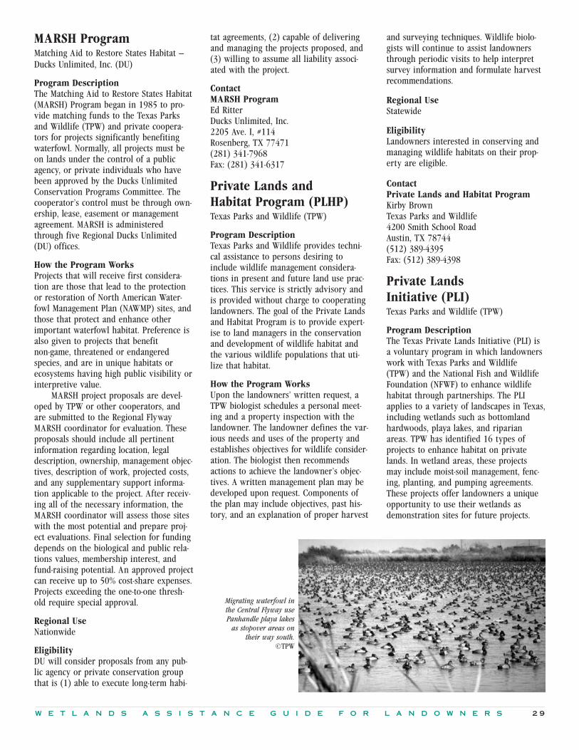
W E T L A N D S A S S I S T A N C E G U I D E F O R L A N D O W N E R S 2 9
MARSH ProgramMatching Aid to Restore States Habitat —Ducks Unlimited, Inc. (DU)
Program DescriptionThe Matching Aid to Restore States Habitat(MARSH) Program began in 1985 to pro-vide matching funds to the Texas Parksand Wildlife (TPW) and private coopera-tors for projects significantly benefitingwaterfowl. Normally, all projects must beon lands under the control of a publicagency, or private individuals who havebeen approved by the Ducks UnlimitedConservation Programs Committee. Thecooperator’s control must be through own-ership, lease, easement or managementagreement. MARSH is administeredthrough five Regional Ducks Unlimited(DU) offices.
How the Program WorksProjects that will receive first considera-tion are those that lead to the protectionor restoration of North American Water-fowl Management Plan (NAWMP) sites, andthose that protect and enhance otherimportant waterfowl habitat. Preference isalso given to projects that benefitnon-game, threatened or endangeredspecies, and are in unique habitats orecosystems having high public visibility orinterpretive value.
MARSH project proposals are devel-oped by TPW or other cooperators, andare submitted to the Regional FlywayMARSH coordinator for evaluation. Theseproposals should include all pertinentinformation regarding location, legaldescription, ownership, management objec-tives, description of work, projected costs,and any supplementary support informa-tion applicable to the project. After receiv-ing all of the necessary information, theMARSH coordinator will assess those siteswith the most potential and prepare proj-ect evaluations. Final selection for fundingdepends on the biological and public rela-tions values, membership interest, andfund-raising potential. An approved projectcan receive up to 50% cost-share expenses.Projects exceeding the one-to-one thresh-old require special approval.
Regional UseNationwide
EligibilityDU will consider proposals from any pub-lic agency or private conservation groupthat is (1) able to execute long-term habi-
tat agreements, (2) capable of deliveringand managing the projects proposed, and(3) willing to assume all liability associ-ated with the project.
ContactMARSH ProgramEd RitterDucks Unlimited, Inc.2205 Ave. I, #114Rosenberg, TX 77471(281) 341-7968 Fax: (281) 341-6317
Private Lands and Habitat Program (PLHP)Texas Parks and Wildlife (TPW)
Program DescriptionTexas Parks and Wildlife provides techni-cal assistance to persons desiring toinclude wildlife management considera-tions in present and future land use prac-tices. This service is strictly advisory andis provided without charge to cooperatinglandowners. The goal of the Private Landsand Habitat Program is to provide expert-ise to land managers in the conservationand development of wildlife habitat andthe various wildlife populations that uti-lize that habitat.
How the Program WorksUpon the landowners’ written request, aTPW biologist schedules a personal meet-ing and a property inspection with thelandowner. The landowner defines the var-ious needs and uses of the property andestablishes objectives for wildlife consider-ation. The biologist then recommendsactions to achieve the landowner’s objec-tives. A written management plan may bedeveloped upon request. Components ofthe plan may include objectives, past his-tory, and an explanation of proper harvest
and surveying techniques. Wildlife biolo-gists will continue to assist landownersthrough periodic visits to help interpretsurvey information and formulate harvestrecommendations.
Regional UseStatewide
Eligibility Landowners interested in conserving andmanaging wildlife habitats on their prop-erty are eligible.
ContactPrivate Lands and Habitat ProgramKirby BrownTexas Parks and Wildlife 4200 Smith School RoadAustin, TX 78744(512) 389-4395Fax: (512) 389-4398
Private Lands Initiative (PLI)Texas Parks and Wildlife (TPW)
Program DescriptionThe Texas Private Lands Initiative (PLI) isa voluntary program in which landownerswork with Texas Parks and Wildlife (TPW) and the National Fish and WildlifeFoundation (NFWF) to enhance wildlifehabitat through partnerships. The PLIapplies to a variety of landscapes in Texas,including wetlands such as bottomlandhardwoods, playa lakes, and riparianareas. TPW has identified 16 types of projects to enhance habitat on privatelands. In wetland areas, these projects may include moist-soil management, fenc-ing, planting, and pumping agreements.These projects offer landowners a uniqueopportunity to use their wetlands asdemonstration sites for future projects.
Migrating waterfowl inthe Central Flyway usePanhandle playa lakes
as stopover areas ontheir way south.
©TPW

3 0 W E T L A N D S A S S I S T A N C E G U I D E F O R L A N D O W N E R S
Conservation Reserve ProgramCRP encourages landowners to enrollhighly erodible cropland or land con-tributing to a serious water quality prob-lem in the Reserve for 10 or 15 years.Landowners receive annual rental pay-ments, technical assistance, and cost-sharing. Purpose is to reduce soil ero-sion and sedimentation, improve waterquality, maintain fish, and wildlife habi-tat, and provide support income to thelandowner.
Time period: at least 10 years.
Land (must have one or more):planted as an agricultural commodity for2 years out of the most recent 5 years;evidence of scour erosion; contributingto or creating a water quality problem;EPA designated wellhead area; participat-ing in easement practices.
FSA
Nationwide
Receive annual rental pay-ment for land while inReserve, not to exceed$50,000 annually; 50%cost-share for establishingvegetation.
How the Program WorksProjects under the PLI are cost-shared bythe landowner and NFWF, while TPWoffers technical assistance and programcoordination. Funding is dependent onavailability of grants.
Regional UseStatewide
EligibilityWetland projects must be a minimum 10 year (negotiable) commitment and thelandowner is obligated to maintain theimprovements. An example of improve-ments include planting a diverse mixtureof legumes and grass surrounded by a4-strand barbed wire fence in playa lakes.Assistance is available on other improve-ments as well. No cost-sharing is availableto reverse damage in playa basins causedby livestock grazing, such as soil erosionand runoff.
ContactPrivate Lands InitiativeKirby BrownTexas Parks and Wildlife 4200 Smith School Road
Austin, TX 78744(512) 389-4395Fax: (512) 389-4398
Wetland Habitat Alliance ofTexas (WHAT)Program DescriptionWetland Habitat Alliance of Texas (WHAT)is an organization dedicated to preservingTexas wetlands by raising public aware-ness and appreciation of wetlands andfunding projects to protect, enhance, andrestore natural wetlands. WHAT also pro-vides youth and adult education andserves as a liaison to the government, con-servation organizations, hunters, and thegeneral public.
How the Program WorksWHAT solicits funds for projects such asmanagement of water on cropped wet-lands, restoration of converted wetlands,enhancement of natural wetlands, and cre-ation of wetlands on non-wetland sites.Interested landowners can receive up to100% financial assistance in return for aminimum 10-year agreement.
The cooperator maintains ownershipof the land upon completion of the project.The cooperator and WHAT agree to anyproposed development on the land beforean agreement is sealed. The NaturalResources Conservation Service (NRCS) willverify the operable conditions; WHAT willpay costs and provide technical assistanceto cooperators within the specifications ofthe agreement. WHAT is interested in work-ing with landowners to find an agreementacceptable to all parties involved.
Regional UseStatewide
EligibilityAny landowner interested in accomplish-ing the same goals as WHAT is eligible toparticipate.
ContactWetland Habitat Alliance of TexasEric FrasierWHAT118 E. Hospital, Suite 208Nacogdoches, TX 75961(409) 569-9428 Fax: (409) 569-6349
Challenge Cost Share ProgramProgram promotes the management,restoration and enhancement of fish andwildlife resources and natural habitatson public and private lands in partner-ship with nonfederal entities.
Summary Table: Federal Programs Providing Financial and Other Incentives for Wetlands Protection
Program Summary Eligibility Contacts/Availability Financial Assistance
Conservation Contract ProgramThe Conservation Contract Programallows landowners to reduce their FmHAdebt in exchange for a permanent con-servation easement on valuable lands,including wetlands.
Land: Projects may occur on NationalWildlife Refuges, fish hatcheries,research facilities, and private lands.Funds provided by the USFWS for proj-ects cannot be matched with other fed-eral funds and are matched 50/50.
USFWS
Nationwide
Matched 50/50.
Time period: 10, 30 and 50 year easements.
Other: Landowner must have borrowedfrom the FmHA. Debt reduction ease-ments will not apply to debts with otherlending institutions.
FSA, NRCS, USFWS
Nationwide
Debt reduction on FSAloans.

W E T L A N D S A S S I S T A N C E G U I D E F O R L A N D O W N E R S 3 1
East Texas Wetlands Project (ETWP)The project will provide landownerswith technical assistance and/or finan-cial incentives to restore, enhance,and/or create natural or man-made wetlands and associated upland habitatswithin the Texas portion of the Lower Mississippi Valley Joint Ventureinitiative area.
Environmental Quality IncentivesProgramThe Environmental Quality IncentivesProgram (EQIP) was established in the1996 Farm Bill to provide a voluntaryconservation program for farmers andranchers who face serious threats to soil,water, and related natural resources.EQIP provides technical, financial, andeducational assistance primarily in des-ignated priority areas, with half of it targeted to livestock-related naturalresource concerns and the remainder toother significant conservation priorities.
Eligibility is limited to persons whoare engaged in livestock or agriculturalproduction. Eligible land includes crop-land, rangeland, pasture, forestland, andother farm or ranch lands where theprogram is delivered.
Program Summary Eligibility Contacts/Availability Financial Assistance
Time Period: 10-year minimum agreement.
USFWS, TPW, NRCS, Ducks Unlimited
East Texas
Program guidelines notfinalized at press.
Time Period: EQIP offers 5- to 10-yearcontracts that provide incentive pay-ments and cost-sharing for conservationpractices called for in the site-specificplan. Contract applications will beaccepted throughout the year.
NRCS, FSA, Extension Service
The program is available inevery State, with an empha-sis on either state-identifiedpriority areas or significantstatewide concerns.
Cost-sharing may pay up to75 percent of the costs.
Forestry Incentives Program (FIP)FIP provides technical and cost-sharedassistance to landowners participating inany one of the four national forestrypractices eligible under FIP: tree plant-ing, improving a stand of forest trees,site preparation for natural regenerationof trees, special forestry practices. FIPmay apply to wetlands conservation andrestoration of wooded swamps
Time period: 10-year maintenanceagreement.
Land: FIP is limited to landowners of 10to 1,000 acres. Exceptions to the acreagelimitation may be obtained for up to5,000 acres. FIP is offered only in desig-nated counties where a suitable numberof ownerships capable of producing atleast 50 cubic feet of timber per yeareach exist. Ornamental, Christmas treeproduction, and orchard tree plantingsare not eligible for FIP funding.
TFS, USFS, NRCS
Primarily East Texas Pineywoods
Cost-shared up to 50%.Maximum annual agencycost-share is $10,000.
North American Wetlands Conservation Act of 1989 (NAWCA)Encourages partnerships among publicagencies and other interests within theUnited States, Canada, and Mexico to protect, enhance, restore, and managewetland ecosystems and other habitatsfor migratory species, especially birds,and their habitats. The Act providesfunding for wetlands conservation proj-ects involving acquisition, restoration,and enhancement.
Time Period: minimum 10-year agreement or a 5-year agreement fordemonstration projects.
Other: Projects involving acquisition,restoration, enhancement, creation, management, and other activities thatconserve wetland ecosystems and thefish and wildlife that depend on suchhabitats are eligible for the Act ormatching partner funds. Areas of specialconcern and larger areas are usuallygiven priority in grant consideration.
USFWS
Nationwide
Federal funding must bematched one-to-one with anon-federal source.

3 2 W E T L A N D S A S S I S T A N C E G U I D E F O R L A N D O W N E R S
Partners for Fish and Wildlife Program (PFW) The objectives of PFW programs are torestore, enhance, and manage wetlandsfor fish and wildlife habitat; promoteprofitable land use for agriculture, indus-try, and private landowners; and pro-mote a wise and lasting land-use ethic.The program focuses on re-establishmentof original natural communities. Pro-gram offers technical and cost-sharedassistance to landowners who wish torestore wildlife habitat, includingdegraded or converted wetlands andthose upland habitats that meet specificeligibility criteria.
Program Summary Eligibility Contacts/Availability Financial Assistance
North American Waterfowl Management Plan (NAWMP)NAWMP’s purpose is to protect, restore,and enhance wetlands important towaterfowl and other wetland-dependentbird species in North America. The planis implemented at the grassroots level bypartnerships called joint ventures.Landowners of wetlands significant towaterfowl may receive technical andfinancial assistance through a variety ofcooperative programs within their geographic area.
Texas Prairie Wetlands Project (PWP)The Texas Prairie Wetlands Project,designed to accomplish the goals andobjectives of the Gulf Coast Joint Venture, is a partnership effort torestore, create or enhance wetlands beneficial for waterfowl and otherwildlife use in 28 Gulf Coast counties. In exchange for financial and technicalincentives, landowners develop a man-agement plan, which may include management of water on cropped lands,restoration of converted wetlands,enhancement of natural wetlands or cre-ation of wetlands on non-wetland sites.
Wetlands Reserve Program (WRP)WRP establishes conservation easementsfor which private landowners receivepayments and cost-shared assistance forrestoring and protecting wetlands ontheir property. WRP provides an excel-lent financial incentive to retire mar-ginal cropland while retaining someagricultural and recreational uses.
Any landowner (federal, state, group, or individual) with property of signifi-cance to waterfowl and otherwetland-dependent species who wishesto restore or enhance land may apply.
USFWS, TPW, Ducks Unlimited, NRCS, WHAT
Three regions in Texas: theGulf Coast, Playa Lakes, andLower Mississippi Valley(East Texas)
Funding variable with JointVenture.
Time period: 10 or more years; demonstration projects may be less than10 years.
Land: Any wetland is eligible forrestoration. Special consideration isgiven to projects meeting specified criteria (refer to program description).Agricultural practices that do not con-flict with conservation purposes areallowed on restoration sites.
USFWS
Nationwide
Cost-shared up to 100% oftotal cost. Demonstrationprojects 50% cost-shared,not to exceed $5,000 if lessthan 10 years.
Time period: 10-year minimum agreement.
Land: Must be 5 acres minimum, havesurface water potential for at least 4 months from September to May.
USFWS, TPW, Ducks Unlimited, NRCS
28 Gulf Coast counties
Cost-shared up to 75% or100% where supplementalwater is provided.
Time period: permanent and 30-yeareasements are available.
Land: no acreage limit. Eligible landsinclude cropped wetlands and prior-converted cropland, adjacent function-ally related uplands, natural wetlandsare eligible as adjacent lands, and ripar-ian areas must link protected wetlands.(public lands, easements, etc.)
NRCS
Nationwide
Participants receive ease-ment payment based on the“agricultural value” of theland after restoration iscomplete; up to 100%cost-shared assistance forrestoration.

W E T L A N D S A S S I S T A N C E G U I D E F O R L A N D O W N E R S 3 3
Program Summary Eligibility Contacts/Availability Financial Assistance
Summary Table: State Programs Providing Financial and Other Incentives for Wetlands Protection
Wildlife Habitat Incentives Program (WHIP)The Wildlife Habitat Incentives Program(WHIP) is a voluntary program for peo-ple who want to develop and improvewildlife habitat primarily on privatelands. It provides both technical assis-tance and cost-share payments to helpestablish and improve fish and wildlifehabitat. WHIP funds are distributed toStates based on State wildlife habitat pri-orities, which may include wildlife habi-tat areas, targeted species and theirhabitats, and specific practices.
Time Period: generally 5- or 10-yearagreements.
Land: Landowner agrees to install andmaintain all WHIP practices.
NRCS
Lands are eligible statewidebased on established pro-gram priorities.
The program provides technical assistance and upto 75% project costs.
Forested Wetlands Incentive Program (FWIP)The Forested Wetlands Incentive Program is a pilot project providing eastern Texas landowners with funds touse sustainable forestry practices thatproduces bottomland hardwood sawtim-ber and improved wildlife habitat.
Landowner Incentive Program (LIP)Most rare species inhabit privatelyowned and managed lands in Texas.Incentive programs to assist privatelandowners in protecting and managinghabitat for rare species can have a directand positive impact on their conserva-tion. It is the goal of this program toprovide financial incentives that encour-age landowners to help conserve rarespecies and their habitat.
The program is f lexible and is opento all private landowners that have adesire to voluntarily manage habitat forrare species on their land. TPW preferprojects with results being able to bedocumented within 5 years.
Time period: 15-year agreements.
Non-industrial private landowners owning bottomlands in eastern Texaswill have priority for funding.
TPW
Eastern Texas
Landowners must provide a15% cost-share, which maybe in-kind and/or cash.
Time Period: no set length of theagreements.
TPW
Statewide
There is a minimum of a 20% landowner match forthe projects.
MARSHMatching Aid to Restore States Habitat ProgramMARSH provides matching funds to pub-lic agencies and private cooperators forprojects significantly benefiting water-fowl. Projects that will receive first con-sideration are those that lead to theprotection or restoration of North Ameri-can Waterfowl Management Plan(NAWMP) sites, and those that protectand enhance other important waterfowlhabitat. Preference is also given to proj-ects that benefit non-game, threatened orendangered species, and are in uniquehabitats or ecosystems having high pub-lic visibility or interpretive value.
Time period: long-term habitat agreements.
Land: Ducks Unlimited will considerproposals from any public agency or pri-vate conservation group that is (1) ableto execute long-term habitat agreements,(2) capable of delivering and managingthe projects proposed, and (3) willing toassume all liability associated with theproject.
Ducks Unlimited Nationwide
Cost-shared assistance up to50%. Costs exceeding thisamount require specialapproval.
Program Summary Eligibility Contacts/Availability Financial Assistance

3 4 W E T L A N D S A S S I S T A N C E G U I D E F O R L A N D O W N E R S
Private Lands and Habitat Program (PLHP)The goal of the Private Lands and Habitat Program is to provide technicalassistance to land managers in the conservation and development of vari-ous wildlife populations that utilizehabitat found on landowner’s property.This service is strictly advisory and isprovided without charge to cooperatinglandowners.
Program Summary Eligibility Contacts/Availability Financial Assistance
Time period: None required.
Land: Landowners interested in conserving and managing wildlife habitats on their property.
TPW
Statewide
This program provides technical assistance only.
Private Lands Initiative (PLI)The Texas Private Lands Initiative (PLI)is a voluntary program, in whichlandowners enhance wildlife habitatthrough partnerships on their lands,including wetlands. TPW has identified16 types of projects to enhance habitaton private lands. In wetland areas, theseprojects may include moist soil manage-ment, pumping agreements, and fencing.
Time period: 10-year minimum (negotiable).
Land: Landowner maintains improvements.
TPW
Statewide
Cost-shared by thelandowner and NationalFish and Wildlife Founda-tion. Funding is dependenton availability of grants.
Clean Water Act: Section404 [33 U.S.C. § 1344(1986 & Supp. 1991)]The U.S. Congress enacted the Clean WaterAct (the Act) to “restore and maintain thechemical, physical, and biological integrityof the Nation’s waters.” Section 404 of theClean Water Act regulates the placement ofdredged and fill material into waters ofthe United States, including wetlands. TheAct authorizes the issuance of permits forsuch discharges as long as the proposedactivity complies with environmentalrequirements specified in Section
404(b)(1) of the Act. Section 404 is theprimary federal program regulating activi-ties in wetlands. The Section 404 programis administered by both the U.S. ArmyCorps of Engineers (Corps) and the U.S.Environmental Protection Agency (EPA),while the U.S. Fish and Wildlife Service(USFWS), National Marine Fisheries Ser-vice (NMFS) and several state agenciesplay important advisory roles.
The Corps has primary responsibilityfor the permit program and is authorized,after notice and opportunity for a publichearing, to issue Section 404 permits. Inevaluating individual Section 404 permit
applications, the Corps determines compli-ance with Section 404(b)(1) guidelinesand carries out a public-interest review.This review involves balancing suchpublic-interest factors as conservation, eco-nomics, aesthetics, wetlands protection,cultural values, navigation, fish andwildlife values, water supply, and waterquality. The Corps also considers com-ments received from the EPA, USFWS,NMFS, and state resource agencies.
EPA is responsible for reviewing andcommenting on permit applications beingevaluated by the Corps. In addition, EPA’sresponsibilities include the following:
Federal Regulations
Wetland Habitat Alliance of Texas(WHAT)WHAT solicits funds for projects such asmanagement of water on cropped wet-lands, restoration of converted wetlands,enhancement of natural wetlands, andcreation of wetlands on non-wetlandsites. The cooperator maintains owner-ship of the land upon completion of the project.
Up to 100% financial assistance.
WHAT
Statewide
Time Period: 10-year minimum.
Land: Any landowner interested inaccomplishing the same goals as WHATis eligible to participate.
Some programs, like the Texas PrivateLands Initiative, provide financial
assistance for fencing to manage grazing.©Texas Dept. of Agriculture

W E T L A N D S A S S I S T A N C E G U I D E F O R L A N D O W N E R S 3 5
• Environmental guidelines: EPA andthe Corps are responsible for estab-lishing the environmental criteriaused in permitting (referred to asthe Section 404(b)(1) guidelines).
• Veto power: EPA can veto a Corpspermit decision (Section 404(c)) ifthe proposed activity would havecertain unacceptable adverseimpacts on the resource, includingunacceptable effects on municipalwater supplies, shellfish beds andfishery areas (including spawningand breeding areas), wildlife orrecreation areas.
• Exemptions: EPA determines theapplicability of exemptions speci-fied in Section 404(f) to the permit-ting requirements.
• Enforcement: EPA takes enforcementactions against people conductingunauthorized discharges of dredgedor fill material into wetlands andother waters of the United States(Section 309). EPA shares thisenforcement authority with theCorps.
The environmental guidelines used toevaluate Section 404 permits generallyprohibit discharges of dredged or fill mate-rial into U.S. waters unless the followingconditions apply:
• There is no available, practicablealternative with fewer adverseeffects on the aquatic ecosystem.
• Dischargers will neither violateother applicable regulations or laws(e.g., state water quality standards,toxic eff luent standards, Endan-gered Species Act), nor significantlydegrade the waters into which theydischarge.
• All appropriate and practicablesteps have been taken to avoid,minimize and otherwise mitigateimpacts on the aquatic ecosystem.
• The activity is water-dependent.A February 6, 1990, Memorandum of
Agreement between EPA and the Corpsclarified that mitigation should occur inthe following sequence: (1) avoidance ofimpacts through evaluation of practicablealternatives; (2) minimization of impacts;and (3) compensation for unavoidableimpacts through restoration or creation.
Geographic Scope of Section 404The geographic scope of regulatory authority under Section 404 has been the
subject of extensive litigation. In 1975, thecourts confirmed that Congress hadintended that the Section 404 program bebroadly applied to all “waters of theUnited States,” not just traditionally navi-gable waters. This phrase includes waterswhich are currently used, were used in thepast, or may be susceptible to use in inter-state or foreign commerce, including:
• all waters which are subject to theebb and flow of the tide;
• the territorial sea;• interstate waters and wetlands;• all other waters (such as intrastate
lakes, rivers, streams, and wet-lands), if their use, degradation ordestruction could affect interstateor foreign commerce;
• tributaries to waters or wetlandsidentified above; and
• wetlands adjacent to waters identified above.
In determining waters that are withinthe scope of the Clean Water Act, Congressintended to assert federal jurisdiction tothe broadest extent permissible under thecommerce clause of the Constitution. Onefactor that establishes a commerce connec-tion is the use or potential use of watersfor navigation. Other factors include (butare not limited to) use of wetland (orother water) as habitat by migratory birds,including waterfowl, use by federal listedendangered species or for recreation byinterstate visitors.
As defined in Section 404 programregulations, wetlands are “those areas thatare inundated or saturated with surface orgroundwater at a frequency and durationsufficient to support, and that under nor-mal circumstances do support, a preva-lence of vegetation typically adapted forlife in saturated soil conditions.” In apply-ing this definition in the field, govern-ment agency scientists use indicators ofvegetation that has adapted to life in wetenvironments (hydrophytic vegetation),hydric (anaerobic) soils and hydrology toidentify wetlands and to establish theirboundaries. In order for a wetland to beconsidered “jurisdictional” and thereforesubject to Section 404 permit review, anarea must have all three criteria (vegeta-tion, soils, hydrology) present under nor-mal circumstances to be considered awetland. The “normal circumstances” crite-rion prevents the individual from eliminat-ing the permit review requirements underSection 404 by destroying aquatic vegeta-
tion and therefore not meeting all threecriteria. Thus, farmed wetlands that dis-play hydric soils and wetland hydrologymay still be considered wetlands eventhough crops have replaced aquatic vegeta-tion.
Activities Regulated By Section 404Section 404 regulates only the dischargeof dredge or fill material into “waters ofthe United States.” Discharges of dredgedand fill material are commonly associatedwith activities such as port development,channel construction and maintenance,fills to create development sites, trans-portation improvements, and waterresource projects (such as dams, jetties,and levees). Excavation activities (e.g.mechanized land clearing, ditching, chan-nelization, runoff from disposal areas, andothers) also result in at least some dis-charge of dredged materials, and are thusregulated.
Some activities which can adverselyaffect or destroy wetlands do not involvethe discharging of dredged or fill materi-als into U.S. waters, and are therefore notregulated under Section 404. These activi-ties include maintenance draining (notnew drainage), clearing, f looding, burning,and soil removal, to name a few.
Under the Clean Water Act, certainactivities are exempt from permittingrequirements (§404(f)(1)). These activitiesinclude:
• normal farming, silviculture, andranching practices;
• maintenance, including emergencyreconstruction of recently damagedparts of currently serviceable struc-tures such as dikes, dams, levees,groins, rip rap, breakwaters, cause-ways, bridge abutments orapproaches, and transportationstructures;
• construction or maintenance offarm or stock ponds or irrigationditches or the maintenance (but notconstruction) of drainage ditches;
• construction of temporary sedimen-tation basins on a construction site,which does not include placementof fill material into waters of theUnited States; and
• construction or maintenance offarm or forest roads or temporaryroads for moving mining equipmentif best management practices arefollowed.

3 6 W E T L A N D S A S S I S T A N C E G U I D E F O R L A N D O W N E R S
Section 404(f)(1) is not intended toexempt activities with more than minorimpacts on aquatic resources. The exemp-tions do not apply if the discharge is partof, or incidental to, an activity whose pur-pose is to convert an area of the waters ofthe United States into a use to which itwas not previously subject, where the flowor circulation of waters of the UnitedStates may be impaired or the reach ofsuch waters reduced. In other words, activ-ities normally considered exempt (e.g.,normal farming) will not be exempt ifthey are conducted with the intention ofconverting wetlands into uplands. Forexample, a farmer would be required toobtain a permit for a discharge to converta wetland area to produce upland crops.The Natural Resources Conservation Ser-vice is responsible for making all wetlanddelineations on agricultural lands.
Introduction to the Permit ProcessDischarges can be authorized by eitherindividual or general permits under Sec-tion 404. If an individual permit isrequired, an application form describingthe proposed activity is submitted to theCorps. Once a complete application isreceived, the permitting agency issues apublic notice containing the informationneeded to evaluate the likely impact of theproposed activity. Notice is sent to allinterested parties, including appropriategovernment agencies at the federal, state,and local level, and others as requested.Any person may request that a public hear-ing be held to consider the application.
The Corps is authorized to issue gen-eral permits on a nationwide, state, orregional basis for categories of activitiesthat have minimal individual and cumula-tive impacts. General permits are issuedfor five-year periods. They allow certainactivities to occur without individual fed-eral permit approval as long as the dis-charger complies with standard conditionsissued by the Corps. General permits elim-inate individual review and thus allow cer-tain activities to occur with little, if any,delay or paperwork. Once issued, a generalpermit may be modified or revoked if thepermitted activities are found to have hadadverse environmental impacts. On acase-by-case basis, the permitting agencymay invoke discretionary authority andrequire a discharger that would otherwisebe covered by a general permit to applyfor an individual permit.
The most significant general permitsare called nationwide permits, becausethey apply throughout the country. Fortynationwide permits exist. In some cases,the landowner is not required to informthe Corps before proceeding with the activ-ity. However, it is a good idea to write theCorps and request a verification that theactivity qualifies for a nationwide permitto avoid potential legal challenges in thefuture. Some activities included undernationwide permits include installing aidsto navigation, minor discharges and dredg-ing, wetland and riparian restoration andcreation activities, temporary construction,boat ramps, and farm buildings.
Making the Permit DecisionThe Corps’ evaluation of a Section 404permit application is a two part testinvolving (1) a determination of whetherthe project complies with the Section404(b)(1) Guidelines, and (2) a publicinterest review. This public interest reviewis a balancing test in which the public andprivate benefits of a project are comparedagainst its adverse impacts to the environ-ment. It includes such considerations asconservation, economics, aesthetics, wet-lands protection, cultural values, naviga-tion, fish and wildlife values, water supply,water quality, energy needs and flooddamage prevention. The Corps also consid-ers all comments received in the permitprocess, whether in response to a publicnotice or a public hearing. A permit mustbe denied if the project fails to complywith the Guidelines or is found to be con-trary to the public interest.
The Section 404(b)(1) Guidelines(Guidelines), published by EPA in conjunc-tion with the Corps, contain substantiveenvironmental criteria used in evaluatingdischarges of dredged or fill material.Under the Guidelines, no discharge can bepermitted if there is a practicable alterna-tive with less adverse impact on theaquatic environment (unless the identifiedalternative poses other significant environ-mental problems).
No discharge can be permitted underthe Guidelines if it would violate otherapplicable laws, such as State water qualitystandards, toxic effluent standards, or theEndangered Species Act. The Guidelinesalso prohibit any discharge that wouldcause or contribute to significant degrada-tion of waters of the United States. In addi-tion, discharges can be permitted under the
Guidelines only if all appropriate and prac-ticable steps are taken to minimize (i.e.,mitigate) the adverse impacts of the dis-charge on the aquatic ecosystem, includingcompensating for unavoidable impacts.
In addition to the evaluation con-ducted by the Corps under the Guidelinesand their public interest review, the permitapplication must comply with several otherregulations, including (but not limited to):
• Section 401 of the Clean Water Actrequires that the state in which anactivity occurs must certify that theactivity complies with the state’swater quality requirements andother applicable laws.
• Similarly, in coastal states with fed-erally approved Coastal Zone Man-agement Programs, an applicant fora Section 404 permit must certifythat the proposed activity complieswith the policies of the stateCoastal Management Program. Forthe permit to be issued, the statemust concur with the applicant’scertification.
• The National Environmental PolicyAct (NEPA) requires that the Corpsconduct an Environmental Assess-ment to determine whether an Envi-ronmental Impacts Statement (EIS)is required. An EIS is required for“major federal activities significantlyaffecting the environment.” Conse-quently, EIS’s are rarely required intypical permit applications.
Compliance with these Acts does notrequire any additional effort by thelandowner; the Corps ensures that theseauthorizations are obtained as part of theapplication process.
Landowners considering manipulationof wetlands on their property are advisedto be aware of and understand the regula-tory programs or laws protecting wetlandresources. Contact your nearest Corpsoffice prior to undertaking wetlands activi-ties on your property.
Contacts for permit information,determination of permit requirements, andpermit application forms are found inAppendix II.
Enforcement of Section 404A 1989 Memorandum of Agreement (MOA)between the Department of the Army andEnvironmental Protection Agency estab-lished policies and procedures between thetwo entities for federal implementation and

W E T L A N D S A S S I S T A N C E G U I D E F O R L A N D O W N E R S 3 7
enforcement of Section 404 of the CleanWater Act. The primary purpose of thisMOA is to maintain the integrity of the 404program through enforcement of permitrequirements while reducing overlap ofresponsibilities between the two agencies.
The Corps, as the permitting agency,has primary responsibility for investigat-ing the majority of enforcement casesinvolving unpermitted discharges as wellas for all Corps-issued permit violations.
The EPA can also enforce againstnon-compliance with permit conditions. EPAgenerally focuses its resources towards dis-covering and enforcing against unpermitted(unauthorized) discharges when the activityinvolves one or more of the following:
• repeat violator(s);• flagrant violation(s);• a Corps determination that an
administrative penalty is war-ranted;
• an EPA request to the Corps that aparticular case or category of casesbe referred to the EPA.
Anyone in violation of the Section 404program, either by conducting an unautho-rized activity or by violating permit condi-tions, is subject to civil or criminal actionor both. Penalties can be imposed by theagencies administratively, that is, withoutuse of judicial procedures. When judicialaction is pursued, the violator may berequired to restore the site and may besubject to payment of fines, imprisonmentor both. The agencies and the courts mayrequire restoration of the site and/or miti-gation at the expense of the violator, oftenin addition to other penalties.
Clean Water Act: Section 401 Water Quality Certification [33 U.S.C. § 1341 (1986)]Section 401 of the Clean Water Act, theState Water Quality Certification program,requires that states certify compliance offederal permits or licenses with state waterquality requirements and other applicablestate laws. Under Section 401, states haveauthority to review any federal permit orlicense that may result in a discharge towetlands and other waters under statejurisdiction, to ensure that the actionswould be consistent with the state’s waterquality requirements. Federal permits that
do not meet these requirements will notreceive a State Water Quality Certification,and thus cannot be issued. Section 401 cer-tification authority is most often used inassociation with U.S. Army Corps of Engi-neers permits under Section 404 of theClean Water Act. Other programs includeSections 9 and 10 of the Rivers and Har-bors Act, and permits or licenses issuedunder the National Pollutant DischargeElimination System (NPDES) of Section 402of the Clean Water Act.
This certification process is routinelydelegated in whole or in part to the stateagency with the authority to regulate thequality of state waters. In Texas, the TexasNatural Resources Conservation Commis-sion (TNRCC) provides a Section 401 certi-fication to the Corps indicating that theproposed activity will comply with theapplicable sections of the Clean Water Actpursuant to the Section 404 permitting pro-gram, and that such activity will notadversely affect the quality of state waters.A Section 404 permit for activities in wet-lands cannot be issued by the Corps untilthis certification from TNRCC has beenobtained or waived as provided by federallaw. Further, no Section 404 permit shall begranted if the Section 401 certification hasbeen denied by TNRCC. Texas oil and gasactivities covered by Section 404 are certi-fied by the Railroad Commission of Texas.
The U.S. Environmental ProtectionAgency (EPA) encourages states to defineprotection of water quality broadly toinclude protection of aquatic life, wildlife,aquatic habitat, vegetation, and hydrologyrequired to maintain the aquatic system.Currently, Texas addresses only aquaticlife. Certification is based on whether aproposed activity would meet require-ments for conventional and nonconven-tional pollutants, water quality standards,
Riparian corridors arevaluable to wildlife as placesof refuge, travel lanes, andfeeding and nesting.©TPW
Barn-yard grassEchinochloa spp.(found in freshwater marshes, providesexceptional waterfowl forage)
Drawing courtesyof North CarolinaAgriculturalResearch Service

3 8 W E T L A N D S A S S I S T A N C E G U I D E F O R L A N D O W N E R S
new source performance standards, andrequirements for toxic pollutants (and anymore stringent, relevant state law or regu-lation). Certification can address physical,chemical, and biological impacts, depend-ing on how a state designs and applies itswater quality standards and other appro-priate requirements of state law. Currently,Texas does not address biological criteria.
However, in response to legislativeaction during the 1999 session, TNRCChas recently completed rulemakingintended to eliminate duplication betweenits 401 certification program and the U.S. Army Corps of Engineers reviewprocess. TNRCC would still be responsiblefor certifying projects for “federally dele-gated or approved programs,” which mayinclude projects located within the CoastalManagement Program boundaries. Forupdates on Section 401 status, please refer to www.tnrcc.state.tx.us or phone(512) 239-1000.
Clean Water Act NationwidePermit 27Nationwide Permit 27 of the Clean WaterAct (see Introduction to the PermitProcess, Section 404, above for an explana-tion of nationwide permits) allows landsthat have been converted to non-tidal wet-lands, through landowner agreementsbetween the USFWS or the NRCS, to bereverted to prior condition and usedwithin five years without requirement ofan individual Section 404 permit orreview by the Army Corps of Engineers.“Prior condition” is the condition as of theinitial effective date of the agreement as itis documented by either the USFWS repre-sentative and/or the NRCS representative.
Section 10, Rivers and Harbors Act of 1899 United States Army Corps of Engineers Section 10 of the Rivers and Harbors Act of1899 requires a permit for dredging or theplacement of fill or structures in navigablewaters of the United States. “Navigablewaters” have been defined by the U.S. ArmyCorps of Engineers (Corps) as “thosewaters that are subject to the ebb and flowof the tide and/or are presently used, orhave been used in the past, or may be sus-ceptible for use to transport interstate orforeign commerce.” This includes the abilityto float a water body and/or use by migra-tory birds. Section 10 is similar to Section404 of the Clean Water Act; however, Sec-tion 404 covers all waters of the UnitedStates without regard to their navigabilityand is therefore much broader in scopethan Section 10. Because of the broadergeographic reach of Section 404, Section 10is often not applicable to wetlands. TheCorps typically combines Section 10 andSection 404 review where their coverageoverlaps in an individual permit request. Aproposed project may require one permit orthe other, or may require both. For exam-ple, projects that may require a Section 10permit but not a Section 404 permit arethose that occur in navigable U.S. watersbut do not require placement of fill intothose waters, and include: channelclean-out, vegetative clearing, and marinaexpansion that requires no fill or dredging.Filling in a waterway or a wetland on anon-navigable river or stream requires onlya Section 404 permit. Contact the nearestCorps office to insure compliance with Sec-tion 10 and/or Section 404 when a projectmay concern a waterway or a wetland.
Endangered Species ActU.S. Fish and Wildlife ServiceThe Endangered Species Act requires fed-eral agencies to conserve endangered andthreatened species. It prohibits any personfrom “taking” endangered or threatenedanimal or plant species. “Taking” is inter-preted broadly to include killing, harass-ing, or harming a protected species. Thedefinition of “harm” includes modifying ordegrading a species’ habitat such that thechange would significantly impair breed-ing, feeding or shelter and would result ininjury to the species.
Under Section 7 of this Act, all federalagencies must ensure that their actions arenot likely to jeopardize the continued exis-tence of any endangered or threatenedspecies or adversely modify or destroy anyof their habitat. These requirements applyto all activities carried out, funded, or reg-ulated by a federal agency, including activ-ities in wetlands.
A state can propose or support thelisting of wetlands-dependent species,thereby bringing the Act’s protection tobear on its wetlands. Listing, however, isbased on the status of the species and isnot simply an attempt to protect wetlands.States can identify potential species, con-duct the research necessary to determinestatus, and, if needed, petition the federalgovernment to include these species. Statesmay also seek to engage landowners inconservation agreements that may pre-clude the need for listing.
The federal government is also sup-posed to designate “critical habitat” for aspecies at the time it is listed. As noted,federal agencies are not authorized to mod-ify adversely or destroy critical habitat.
For listed species, the U.S. Fish andWildlife Service is required to prepare“recovery plans” that outline a strategy toconserve and recover the species. Recoveryplans should outline habitat protectionand other steps necessary for the conser-vation of the species. States and otherstakeholders often play a role in the devel-opment of recovery plans.
Under Section 10, permits can beissued that allow the “taking” of endan-gered or threatened species that occursincidentally to otherwise lawful activities.Long term habitat conservation plans(HCPs) must be developed as part of thepermit application process. States maywish to initiate or participate in the prepa-Caddo Lake
©Dan Moulton

W E T L A N D S A S S I S T A N C E G U I D E F O R L A N D O W N E R S 3 9
ration of HCPs and to advocate for wet-lands protection as part of the plans. How-ever, HCPs may be of limited use forwetlands protection because they requirethe presence of a federally listed endan-gered or threatened species. In addition,they are intended for activities not subjectto federal permits, and many wetlandsactivities require federal permits.
Food, Agriculture, Conservation and Trade Act of 1990 (SwampbusterProvisions)United States Department of Agriculture (USDA)The Swampbuster Provisions are part ofthe amended 1990 Food, Agriculture, Conservation and Trade Act (1990 FarmBill). Swampbuster withholds USDA bene-fits to farmers who convert wetlands intocroplands after December 23, 1985.Swampbuster reduces the incentives toconvert wetlands to croplands by denying
eligibility for almost all farm program ben-efits on all acres operated by a growerwho either converts a wetland or plantson a converted wetland. Benefits that maybe withheld include:
• farm storage facility loans underthe Commodity Credit Corporation(CCC) Charter Act;
• disaster payments under the Agri-cultural Act of 1949;
• crop insurance under the FederalCrop Insurance Act;
• FmHA loans payment for storage ofan agricultural commodity underthe CCC Charter Act.
• Program benefits may be lost in thefollowing programs: AgriculturalConservation Program (ACP), Emer-gency Conservation Program (ECP),Small Watershed Program (SWP),Conservation Reserve Program(CRP), Environmental EasementProgram (EEP), disaster assistancefor tree planting, and Water QualityProtection Programs (WQP).
When applying for federal farm pro-gram benefits, landowners indicatewhether they plan to manipulate any “wet”areas. If so, the USDA must determine ifthese “wet” areas are wetlands. Conversionof wetlands may result in Swampbusterviolations. For violations, USDA must con-duct a site visit before reducing programbenefits. A violator can regain eligibilityfor future farm program benefits by restor-ing the converted wetland to its originalcondition. Landowners may, however, pre-pare a mitigation plan that allows them toproduce an agricultural commodity on con-verted wetlands that were either fre-quently cropped, or converted between1985 and 1990, in exchange for restoringprior converted cropland on their prop-erty. Mitigation plans must be approvedprior to conversion of the wetlands.Landowners should contact the Farm Ser-vice Agency before working on any poten-tial wetland areas on their land to avoidforfeiting USDA benefits, and to learnmore about preparing mitigation plans.
State Programs and RegulationsBest Management Practices ProjectTexas Forest Service With cooperative funding from the Envi-ronmental Protection Agency and theTexas State Soil and Water ConservationBoard, the TFS implemented an educa-tional project encouraging forest landown-ers, loggers and foresters to voluntarilyimplement forestry best management prac-tices (BMPs). Texas forestry BMPs protectwater quality and address planning, roadconstruction and maintenance, harvesting,site preparation and planting, prescribedburning, silvicultural chemicals, andStreamside Management Zones (SMZs).
Major educational components of theBMP Project currently include a programon Continuing Education for logging pro-fessionals on Best Management Practices.This program, while initiated by the TFSBMP Project, now works cooperativelywith the TFA and the SFI. Nearly 60 day-long workshops all across East Texas haveprovided in-depth BMP training both inthe field and in the classroom to nearly1,300 logging contractors and crew fore-
men. Workshop participants have giventhe workshop a 98% recommendation ratefor others to attend. Other workshops forlogging professionals cover wetlands,endangered species, silviculture, andwildlife habitat.
A Wetland/BMP Coordinating Commit-tee, chaired by the BMP Project Leader,meets every nine months and consists ofrepresentatives from all major agenciesand entities involved in forestry, wetlands,water quality in Texas. This group ensuresthat communication channels among vari-ous agencies remain open.
BMP demonstration forests are locatedon state lands in East Texas and are avail-able for loggers, landowners or land man-agers to see side-by-side demonstrations ofvarious BMPs. To accommodate those whoare unable to visit a state forest, virtualtours of these demonstration areas can befound on the TFS home page atwww.txforestservice.tamu.edu.
Educational efforts have includedextensive use of radio, television, bill-boards, and newspapers to reach forestlandowners and the general public. Thirty-second television commercials on BMPs
have aired extensively in East Texas. Acooperative billboard, funded by the TFSand each of the four major timber compa-nies in the area, was installed along amajor highway. It can be viewed by occu-pants of 11,000 vehicles per day.
Recognizing that unpaved county roadscan have a major water quality impact, theBMP Project has provided water qualityawareness training to county road crewsand county commissioners. This newlyformed relationship is expected to be mutu-ally beneficial due to the natural linkagesbetween forest industry and county roads.
Landowner workshops have been con-ducted in areas of the state where countylandowner associations have been lacking.These workshops provided informationalresources for landowners on not just waterquality, but also other stewardship issueslike tree planting, wildlife and sustainableforestry.
In 1998, the TFS BMP Project receivedthe Governor’s Environmental ExcellenceAward for its outstanding educationalefforts.
The TFS BMP Project expects to con-centrate educational efforts in the Cypress

4 0 W E T L A N D S A S S I S T A N C E G U I D E F O R L A N D O W N E R S
Basin area of Northeast Texas through2002. This highly sensitive watershed is agreat location to target educational efforts,though a statewide presence will still bemaintained. Monitoring for BMP compli-ance will continue to occur to evaluate the effectiveness of this non-regulatoryBMP program.
Texas Coastal Management ProgramTexas General Land OfficeThe Texas Coastal Management Program(CMP) was developed to more effectivelyand efficiently manage coastal naturalresource areas and the uses that affectthem. The CMP is a tool for balancing pro-tection of coastal natural resources withencouragement of economic growth. TheCoastal Coordination Council, comprisedof state, local, and public representatives,was formed to coordinate the currentcoastal programs, statutes, and rulesadministered by federal, state, and localagencies. The Council’s rules establishingCMP goals and policies are based on exist-ing local, state and federal law and regula-tions. A major role of the CoastalCoordination Council is to review agencyactions for consistency with the goals andpolicies. Policies of greatest interest tolandowners address:
• Oil and gas development, waste discharge, and oil spills;
• Non-point source pollution(includes only the voluntary pro-gram of the State Soil and WaterConservation Board);
• Development in Critical Areas,which include coastal wetlands,tidal sand and mudflats, oysterreefs, and seagrass beds;
• Construction of waterfront facilitieson submerged lands;
• Development within coastal barrierresource systems; and,
• Instream flows and freshwaterinflows to waters under tidal influence.
The rules explicitly state that theCouncil will not apply the goals and policies in a manner that would result inthe taking, damage, or destruction of property, without adequate compensation,by the Council. The CMP covers 18 coastalcounties that contain tidal waters (Orange,Jefferson, Chambers, Harris, Galveston,Brazoria, Matagorda, Jackson, Victoria, Calhoun, Refugio, Aransas, San Patricio,Nueces, Kleberg, Kenedy, Willacy,Cameron). The following management policies related to wetlands are includedin the CMP:
• The CMP contains policies for mini-mizing adverse effects of coastalactivities on coastal wetlands;
• Coastal wetlands are definedaccording to the current federaljurisdictional definition. The inlandboundary of coastal wetlands fol-lows TNRCC tidal segment bound-aries and road boundaries in theOil Spill Prevention and ResponseAct of 1991;
• The goal for protection of coastalwetlands is “no net loss of func-tions and values;”
• The CMP does not add new regula-tory requirements for wetlands, butit is based primarily on current reg-ulations and authorities, such asSections 404 and 401 of the CleanWater Act, and no new permits arerequired. More information on theCMP can be obtained by calling(512) 463-5385 or 475-1468.
Water Diversion under the Texas Water Code (Section 11.121)Texas Natural Resources Conservation Commission The Texas Water Code states that individu-als cannot appropriate state water, or beginconstruction of any work designed for thestorage, taking, or diversion of water, with-out first obtaining a permit from the TexasNatural Resources Conservation Commis-sion for the appropriation. However, per-sons wishing to construct for personal useon their own property a dam or reservoirto impound or contain not more than 200acre-feet of water for domestic and live-stock purposes, including wildlife habitat,are exempt from this permit requirement.For more information, please contact theTexas Natural Resources Conservation Com-mission, Water Policy and Regulations Divi-sion at (512) 239-4805.
Smooth Cord-grassSpartina alternif lora(found in saline marshenvironments)
Drawingcourtesy ofNorth CarolinaAgriculturalResearchService
Landowners can receivefinancial assistance forwater control structures
such as this one tomanage water levels in
their wetlands.©TPW

W E T L A N D S A S S I S T A N C E G U I D E F O R L A N D O W N E R S 4 1
Organizations and Program Abbreviations
FSA Farm Service Agency Corps United States Army Corps of
EngineersCRP Conservation Reserve ProgramDU Ducks Unlimited, Inc.EPA U.S. Environmental Protection
AgencyEQIP Environmental Quality Incentives
ProgramFIP Forestry Incentive ProgramFSP Forest Stewardship ProgramFWIP Forested Wetland Incentive
ProgramGCJV Gulf Coast Joint VentureGLO General Land OfficeGPCP Great Plains Conservation
ProgramLIP Landowner Incentive ProgramLMVJV Lower Mississippi Valley Joint
VentureMARSH Matching Aid to Restore States
HabitatNAWCA North American Wetlands
Conservation ActNAWMP North American Waterfowl
Management PlanNRCS Natural Resources Conservation
Service PFW Partners for Wildlife ProgramPLHP Private Lands and Habitat
ProgramPLI Private Lands InitiativePLJV Playa Lakes Joint VentureTPWP Texas Prairie Wetlands ProjectSIP Stewardship Incentive ProgramTFS Texas Forest ServiceTNRCC Texas Natural Resources
Conservation CommissionTPW Texas Parks and Wildlife USDA United States Department of
AgricultureUSFS United States Forest ServiceUSFWS United States Fish and Wildlife
ServiceWHAT Wetland Habitat Alliance of TexasWHIP Wildlife Habitat Incentives
ProgramWRP Wetlands Reserve Program
Contacts in Texas for Wetland Incentive Programs
Challenge Cost Share ProgramSonya BrownU.S. Fish and Wildlife ServiceRefuges and Wildlife500 Gold SWAlbuquerque, NM 87103(505) 248-6824
Conservation Contract ProgramRobert C. HopperChief of Farmer ProgramsFarm Service Agency101 S. Main Street, Suite 102Temple, TX 76501(254) 774-1304Fax (254) 774-1477
Conservation Reserve ProgramSammy OrangeConsolidated Farm Service AgencyP.O. Box 2900College Station, TX 77841(409) 260-9235Fax (409) 260-9488
Wetlands Reserve ProgramDoug Sharer Natural Resources Conservation Service101 S. Main StreetTemple, TX 76501-7682(254) 298-9825 Fax (254) 742-9848
MARSH ProgramEd RitterDucks Unlimited, Inc.2205 Ave. I, #114Rosenberg, TX 77471(281) 341-7968 Fax: (281) 341-6317
North American Waterfowl Management PlanNorth American Wetlands Conservation ActVernon BevillTexas Parks and Wildlife 4200 Smith School RoadAustin, TX 78744(512) 389-4578Fax (512) 389-4398
• Playa Lakes Joint VentureBill JohnsonTexas Parks and Wildlife P.O. Box 659Canyon, TX 79105(806) 655-3975
• Gulf Coast Joint VentureDavid S. LobpriesTexas Parks and Wildlife 6414 Deer Trail DriveWharton, TX 77488(409) 532-5517
• Lower Mississippi Valley Joint VentureCarl D. FrentressTexas Parks and Wildlife Route 3, Box 3273Athens, TX 75751(903) 675-4177
Partners for Fish and Wildlife ProgramMike McCollumU.S. Fish and Wildlife Service711 Stadium Dr., Suite 252Arlington, TX 76011(817) 885-7830Fax (817) 885-7835
Texas Prairie Wetlands ProjectDavid CurtisTexas Prairie Wetlands ProjectU.S. Fish and Wildlife Service312 S. Main Street, Room 310Victoria, TX 77901(361) 576-0282Fax: (361) 575-9537
orCraig LeSchackTexas Prairie Wetlands ProjectDucks Unlimited, Inc.2205 Ave. I, #114Rosenberg, TX 77471(281) 341-7968 Fax: (281) 341-6317
Private Lands InitiativePrivate Lands and Habitat ProgramKirby BrownTexas Parks and Wildlife 4200 Smith School RoadAustin, TX 78744(512) 389-4395 Fax (512) 389-4398
Appendix I — Programs and Contacts

4 2 W E T L A N D S A S S I S T A N C E G U I D E F O R L A N D O W N E R S
Agencies like the Natural Resources Conservation Service providetechnical assistance to landowners for wetland management.
©Texas Dept. of Agriculture
Forestry Incentive ProgramForest Stewardship ProgramTom BoggusTexas Forest Service (TFS)College Station, TX 77843-2136(409) 845-2641 Fax (409) 845-5764
Mark Freeman USDA-NRCS101 South Main Street Temple, TX 76501 (254) 742-9822
Scotty ParsonsTexas Parks and Wildlife 1805 E. Lufkin Ave.Lufkin, TX 75901(409) 639-1879
Wetland Habitat Alliance of TexasEric FrasierWHAT118 E. Hospital, Suite 208Nacogdoches, TX 75961(409) 569-9428Fax (409) 569-6349
The Private Lands andHabitat ProgramTexas Parks and Wildlife
Region 1 Panhandle/West TexasDirector: Ruben Cantu3407 S. ChadbourneSan Angelo, TX 76904(915) 651-4748
Region 2North CentralDirector: Roy D. Welch1601 East CrestWaco, TX 76705(817) 799-2564
Region 3East TexasDirector: Nathan Garner11942 FM 848Tyler, TX 75707(903) 566-1626
Region 4Coastal & South TexasDirector: David Mabie715 S. Hwy. 35Rockport, TX 78382(512) 729-2315
Persons interested in receiving technicalassistance for private lands enhancementshould contact the above Wildlife Divisionregional office for their respective area orcontact: Kirby Brown, Program Director,Private Lands and Habitat Program, TexasParks and Wildlife, 4200 Smith SchoolRoad, Austin, Texas 78744, (512) 389-4395

4 3 W E T L A N D S A S S I S T A N C E G U I D E F O R L A N D O W N E R S
Federal Agencies
Federal Information CenterWashington, D.C. 1 (800) 366-2998
USDA State Contacts
NRCS State Office101 South Main StreetTemple, TX 76501(254) 742-9800The above number can direct you to theappropriate USDA Service Center.
U.S. Army Corps of Engineers(Having jurisdiction in Texas)
Ft. Worth (817) 334-2681Galveston (409) 766-3930Tulsa (918) 581-7261Albuquerque (505) 766-2776
USFWS Texas Regional Offices
U.S. Fish & Wildlife ServiceEcological Services Austin Field Office10711 Burnet Road, Suite 200Hartland Bank BuildingAustin, TX 78758(512) 490-0057 Fax (512) 490-0974
Field SupervisorU.S. Fish & Wildlife Service711 Stadium Drive, Suite 252Arlington, TX 76011(817) 885-7830 Fax (817) 277-1100
Field SupervisorU.S. Fish & Wildlife Service17629 El Camino Real, Suite 211Houston, TX 77058(281) 286-8282 Fax (281) 488-5882
Field SupervisorU.S. Fish & Wildlife Servicec/o TAMU-CCCampus Box 3386300 Ocean DriveCorpus Christi, TX 78412(361) 994-9005 Fax (361) 994-8262
West Texas Suboffice U.S. Fish and Wildlife ServiceContact the Arlington Office for the updated address and phone numbers.
U.S. Environmental Protection Agency
U.S. Environmental Protection Agency1445 Ross AvenueDallas, TX 75202-2733(214) 665-8332Wetlands Hotline: 1 (800) 832-7828
Texas State Agencies
Texas Department of AgricultureP.O. Box 12847Capitol StationAustin, TX 78711(512) 463-7476
Texas Forest ServiceForest Resource Development DepartmentCollege Station, TX 77843-2136(409) 845-2641
Texas General Land Office1700 N. Congress Austin, TX 78701(512) 463-5001
Texas Natural Resources ConservationCommissionP.O. Box 13087Capitol StationAustin, TX 78711-3087(512) 239-1000
Texas Parks and Wildlife 4200 Smith School RoadAustin, TX 78744(512) 389-4800
Texas Water Development Board1700 N. Congress AvenueAustin, TX 78711(512) 463-7847
Natural Resources Conservation Service
NRCS State Office101 South Main StreetTemple, TX 76501(254) 742-9800The above number can direct you to theappropriate local USDA Service Center.
Texas Agriculture ExtensionService Area Offices
District 1Panhandle6500 Amarillo Blvd., W.Amarillo, TX 79106(806) 359-5401 Fax (806) 358-9718
District 2South PlainsRoute 3, Box 213 AALubbock, TX 79401-9746(806) 746-6101Fax (806) 746-6528
District 3Rolling PlainsP.O. Box 2159Vernon, TX 76385-2159(817) 552-9941Fax (817) 553-4657
District 4North 17360 Coit RoadDallas, TX 75252-6599(214) 231-5362Fax (214) 231-5600
District 5EastP.O. Box 38Overton, TX 75684(903) 834-6191Fax (903) 834-7140
District 6Far WestP.O. Box 1298Ft. Stockton, TX 79735-1298(915) 336-8585 Fax (915) 336-3813
Appendix II — Federal and State Offices

4 4 W E T L A N D S A S S I S T A N C E G U I D E F O R L A N D O W N E R S
District 7West Central7887 North Hwy. 87San Angelo, TX 76901-9728(915) 658-4576 Fax (915) 658-4364
District 8CentralRoute 2, Box 1Stephenville, TX 76401(817) 968-4144 Fax (817) 965-3759
District 9Southeast P.O. Box 2150Bryan, TX 77806-2150(409) 845-6800 Fax (409) 845-6501
District 10SouthwestP.O. Box 1849Uvalde, TX 78802-1849(210) 278-9151 Fax (210) 278-4008
District 11Coastal BendRoute 2, Box 589Corpus Christi, TX (512) 265-9203 Fax (512) 265-9439
District 12South2401 East Hwy. 83Weslaco, TX 78596(210) 968-5581 Fax (210) 969-5639
Private Organizations
Ducks UnlimitedKen BabcockDirector of Operations, Southern Regional OfficeDucks Unlimited193 Business Park Drive, Suite ERidgland, MS 39157(601) 956-1936
Ed RitterRegional Biological SupervisorDucks Unlimited, Inc.2205 Ave. I, #114Rosenberg, TX 77471(281) 341-7968
SpikerushEleocharis spp.(freshwater marshesand streams)
Drawingcourtesy ofNorth CarolinaAgriculturalResearchService

W E T L A N D S A S S I S T A N C E G U I D E F O R L A N D O W N E R S 4 5
A variety of wetlands education programsoffered by a range of public and privategroups are available that cover wetlandstopics ranging from regulations to youtheducation. Please consult Roles of Fed-eral and State Agencies in Wetlands inthis document to match your area of inter-est to the appropriate agency. Agency con-tacts can be found in Appendix II. Theprograms summarized below may offerwetlands education and monitoring train-ing opportunities to adults.
Adopt-A-Wetland ProgramNivra KelleyCenter for Coastal StudiesTexas A&M University – Corpus Christi6300 Ocean DriveCorpus Christi, TX 78412(512) 994-9005
Purpose: Participants are encouraged todisseminate wetland information to youthby utilizing a variety of approaches includ-ing monthly monitoring of f lora, fauna,and water quality at a wetland in theirarea. The program also encourages stu-dents to participate in wetland restoration,creation, and enhancement projectsthrough surveying and monitoring activities.
Project and Aquatic WILDTexas Parks and Wildlife 4200 Smith School RoadAustin, TX 78744(512) 328-6035
Purpose: The goal of Project WILD(Wildlife in Learning Design) is to assistlearners of any age in developing aware-ness, knowledge, skills, and commitmentthat results in informed decisions, respon-sible behavior, and constructive actionsconcerning wildlife. Aquatic WILD is a similar program that offers conservationeducation of our aquatic resources.
Texas WatchTexas Natural Resources Conservation CommissionP.O. Box 13087 Capitol StationAustin, TX 78711-3087(512) 239-4738
Purpose: Texas Watch is designed to helpvolunteer environmental monitoring pro-grams address environmental problems.This volunteer program helps to produceenvironmental information that agencies,waste generators, and the public need tomake environmentally sound decisions.
MARSH M.A.L.L.O.W. ProgramWill CohenTy HarrisTexas Agricultural and Extension ServiceRt. 2 Box 589Corpus Christi, TX 78406(361) 265-9203
Purpose: Marsh Management Activitiesfor Learning the Lifestyles Of Wildlife. Volunteer leaders, teachers and youth(ages 8 to 18) manage a wet area (i.e.,pond, wetland) for one or two wildlifeand/or fish species. They develop a man-agement plan, implement the plan, evalu-ate the project, conduct communityoutreach, and present their results to theirpeers. Awards and trophies are presentedto winners and certificates of achievementare given to all participants.
Appendix III — Wetlands Education Assistance
Citizen monitoring of wetlandscan provide helpful data to
resource agencies.©TPW

Three white-tailed deer bounded out fromthe creek bottom and ran down the draw. Acovey of bobwhite quail f lushed frombeneath a nearby tree, a belted kingfisherperched on an overhanging limb as hehunted for food, and evidence of RioGrande turkey and porcupine was every-where. Wetland vegetation including wil-low, buttonbush, cottonwood, hackberry,sedges, and black locust f lourished. Ground-water formed small pools in the creek bot-tom, which are replaced by a swift f lowingstream during spring rains.
It is easy to imagine that this creekbottom is part of a park, but in fact, it ison L.H. Webb’s 9,440-acre Seven CrossRanch in the Rolling Plains near Amarillo.This riparian area has benefited from a 4-strand barbed-wire fence built around 4.5 acres of creek bottom, which enhancesthe landowner’s ability to manage the site.Since the fence was built in the summer of1993, native vegetation beneficial towildlife has been reestablished. The cost ofthe barbed-wire fence was shared by Mr.Webb and Texas Parks and Wildlife throughthe Private Lands Initiative, a state programthat provides technical and financial assis-tance to landowners for wildlife enhance-ment projects.
Mr. Webb had previously consideredcontrolled grazing on the bottom, when hewas contacted by former TPW waterfowlbiologist Jim Ray and TPW Technical Guid-ance Biologist Gene Miller. Mr. Webb wasinterested but reluctant to invite govern-ment involvement on his land. After assur-ances from Jim and Gene that the programwas voluntary, Mr. Webb agreed to partici-pate, and has been pleased with the results.
The Private Lands Initiative projectinvolved installing one-half mile of fencearound 4.5 acres of creek bottom. Fourwood duck boxes, provided by TPW, wereinstalled in the fenced riparian area. Underthe agreement, Mr. Webb can graze cattlefor short durations. Short duration grazingcan be beneficial to plants by stimulatingthe growth of native vegetation. Hoofaction loosens the soil and works seedsinto it, and sunlight penetrates where feed-ing cattle have removed some of the thickvegetation. Fencing key wildlife areas like
this prevents overgrazing and protectsnative vegetation that stabilizes streambanks and provides wildlife cover. Often,water quality and erosion problems areimproved.
Mr. Webb has seen the benefits of con-trolled grazing on his property. Easterngamma grass, a native grass that providesfood, cover and nesting for wildlife, hasreturned to the areas where grazing hasbeen controlled. “You don’t see it when thearea is continuously grazed because it’s likeice-cream to cows – it’s the first thing theygo for. It only comes in when cows arefenced out and rest periods are provided,”observes Mr. Webb.
While fencing provides benefits to theland and the wildlife that live on it, thePrivate Lands Initiative project providesperhaps the biggest benefit to the cattle.Controlled grazing allows some of the morepreferable grasses, such as eastern gammagrass, to re-establish. When this area isgrazed, cattle feed on a higher quality for-age, and more of it. This translates intodirect benefits to the landowner by produc-ing a healthier stock. “Cattle are the besttool a landowner has to maintain land ingood condition,” asserts Mr. Webb. “Con-trolled grazing through the use of fencingprovides a win-win situation for thelandowner, cattle, and the wildlife.”
Fencing areas for wildlife on sites thatare near each other provides a travel corri-dor for plains wildlife and could result inlocal population increases. Gene Millerstates that, “As more landowners under-stand the value of fencing riparian areas
and playas to manage livestock grazing,Panhandle water, wetlands, and wildlifewill benefit. If enough people managedriparian areas and playas for wildlife, theeffect would be significant.”
In 1999, Mr. Webb and his familyreceived the Excellence in Wildlife Conser-vation Land Stewardship Award from theTexas Chapter of the Wildlife Society forhis lifetime commitment to managing theranch to conserve and benefit wildlife habi-tat. Mr. Webb hosted a Wildlife Manage-ment Field Day cosponsored by Texas Parksand Wildlife and the Texas Wildlife Associa-tion in July 1999. The Field Day wasattended by over 110 participants, includ-ing many landowners, sportsman, andwildlife watchers.
L. H. Webb
p r o f i l e
L. H. Webb (above)and fencing projectunder the PrivateLands Initiative (left).©Jule Anderson

The Reed Ranch has been in the Reed fam-ily for a little over 50 years. Jim and hisfamily took over management of the ranchabout 4 years ago. This ranch was passedon to him by his father.
The first thing we did was to plan forwhat we wanted to do with the ranch. Tous, this meant setting some goals that werein line with our values.
We found the best goal modelingprocess to be Holistic Resource Management(HRM designed by Allan Savory). The wholefamily participated and it was the bestthing we could have done at that time.From that time on, we’ve made day-to-daydecisions based on these goals. The involve-ment of the Texas HRM group has also beenimportant to our family.
Mostly, these goals have to do withthree things.
• diversification of the uses of theranch
• maintaining a productive and flexi-ble lifestyle
• being a good steward of the landand using informed decision-makingprincipals which are in line withour goals
The use of the holistic managementprocess is one of the major reasons we’vemade the progress we’ve made. We couldn’tbe doing what we’re doing without thismodel to follow. When we’re trying tomake a decision about whether to do some-thing or not, we test our decision againstour goals using the seven testing guidelinesthat are found in the HRM model.
Right now, we have several incomestreams that everyone is enjoying. At onetime, the only major income stream wasthe ranch’s cow/calf operation. Cattle willalways be a major player in the overallgoals of the ranch. We recognize that cattlecan be used as a tool in the improvementof the soil and grasses if a systematic graz-ing plan is utilized.
Now, the ranch is separated into manypaddocks using electric fencing. The parti-tioning of the ranch into small operatingunits was one of the best things we couldhave done. The creation of a systematicgrazing system was some best dollars we’vespent. These small paddocks allow us tocreate Forage units and wildlife units at thesame time. We rotate the uses of the vari-ous units whenever we feel the need suitsour goals.
There’s now a hunting club operatingon the Reed Ranch. The creation of Ol Jim’sHuntin’ and Fishin’ Club has allowed us toenjoy many more uses of the ranch and hasincreased the income flow, too.
We’re now enjoying the hunting andfellowship of deer hunting, duck hunting,hog hunting, fishing, varmint hunting,camping, hanging out enjoying the out-doors with our friends, and watching thegrass grow.
We use the Internet to share huntingstories, our photo’s, and ranch projects. Aranch calendar is also kept on the Internet.This calendar is used by all the club mem-bers to know what’s going on so they canplan their activities.
Our ranch photo albums can be foundat: http://www.photoloft.com/allalbums.asp?s=jasc&u=116511
Our ranch calendar can be found at:http://www.calendars.net:8189/jreed1
A major emphasis has been placed onthe return of some of the pastureland tonative prairie grasses. More than half of the1,780-acre ranch is located in the TrinityRiver wetlands basin. Grasses that were atone time native to the area are beingplanted to return the soil to its productiveconditions once again.
The grasses selected will need to with-stand the moisture and other bottomlandsconditions. The grasses also need to supplyample cover and habitat for wildlife, andproduce ample forage for cattle. So far, thetwo grasses that are being utilized now inthe bottomlands for these purposes arealamo switchgrass and eastern gamagrass.
Our forested wetlands project with theTexas Parks and Wildlife Department hasgiven us the opportunity to meet some ofour major goals for the ranch. The forested
wetland project is allowing us to repairover 400 acres of bottomland hardwoodforests that are severely degraded fromyears of high grading. In addition, we arereturning large portions of the pasturelandback into bottomland forests by plantingseedlings. We’re seeing that the manage-ment of our timber and wetlands is nowreceiving about the same emphasis as thenative grassland prairie.
There’s still lots to learn about timbermanagement and wetland habitats. With thehelp given by our wildlife biologists andforesters, we feel we’re heading in the rightdirection. One of our early-on goals had todo with the stewardship of healthy forestsand wildlife habitat.
At first, we didn’t have a clue abouthow to approach this. However, when theforested wetlands project came along, itgave us the opportunity to make informed,solid decisions based on our goals for theranch. In addition, we continue to useHRM’s seven testing guidelines in our deci-sion making.
If anybody would like more informa-tion about the Reed Wildlife Ranch, Jim canbe contacted at [email protected]. Ol Jimcan also be found participating on the talkforums at www.texasboars.com.
Jim, Judy and Jimmy Reed • Reed Wildlife Ranch
p r o f i l e
Jim, Judy, and JimmyReed (above) andReed Wildlife Ranch’sbottomland (left).©The Reeds

To Dr. Robert McFarlane, owning land is aprivilege and a responsibility. His 7,200acres in Anderson County is situated nearthe center of one of the richest habitats inTexas – the bottomland hardwood forestsof the Trinity River Basin. In fact, threeWildlife Management Areas and one StatePark are within 12 miles of his boundary.As a child, McFarlane roamed the BigWoods of the Trinity and Catfish Creek bottom where he learned the habits ofwhite-tailed deer, ducks, and even mountain lions.
Dr. McFarlane’s primary focus on theland has been habitat development forwaterfowl and deer. His goal is to create atrophy deer lease operation without resort-ing to high fencing. He has learned that thewildlife, and the habitat upon which theydepend, can only be enhanced to a point,unless the landowner goals fit in with thegreater ecosystem around him. This is trueespecially with migratory birds like ducksthat depend upon permanent wetlands on aregional scale. These ideas led to the devel-opment of the Trinity River Basin Conser-vation Cooperative, a public/privatepartnership with TPW lands, TDCJ lands,and private ranches involving over 100,000 acres Anderson and Freestonecounties. The cooperative hopes to eventu-ally create an extensive corridor of wildlifehabitat along the Trinity River, from Kaufman County to Madison County. Thiseffort would not only protect vital water-
fowl wintering habitat, but could eventuallylead to large scale watershed managementfor insuring adequate water quality andquantity to meet future needs.
Dr. McFarlane’s land investment todayis from the heart – to permanently protectand restore the ecosystem he rememberedas a child so that someday his children andgrandchildren can share the same experi-ences. McFarlane realizes that today, perma-nent land conservation in a private landstate like Texas requires more than a will-ing attitude – it must make economic sense.That’s why he established a partnershipwith Pinnacle Gas Company and the ArmyCorp of Engineers to create a federal wet-land mitigation bank. This innovative con-servation tool will create a 50-acre marshand restore approximately 400 acres of bot-tomland hardwoods through the purchaseof mitigation “credits” by entities that havedamaged wetlands elsewhere in the region.The Corp administers the credits from the“bank” in lieu of mitigating on-site damagesthrough planting trees or re-creating wet-lands. This speeds up the process of mitiga-tion, an attractive alternative to industrywith the finances to make habitat restora-tion a reality. Then, the “bank” essentiallybecomes a conservation easement, so thatthe mitigated habitat is protected in perpetuity.
In addition, Dr. McFarlane has devel-oped another 900 acres of green-tree andopen water marshes through the construc-
tion of a levee system, and has erectedabout 60 wood duck boxes. McFarlane’s 13-year old son Scot relates a story abouthunting ducks with his father in themarshes on their land: “We were quiet aswe drove in the still dark morning, but bythe time we got to the area where theroad putters out and walking was a must,the morning light was just coming out. Onthe walk to the marsh, there were owls inthe trees, a wild boar cantered across thetrail, and a young buck stopped on thetrail to look at us. My father lives on thishaven, but I board at school right in theheart of Houston, a busy metropolis filledwith cars, buildings, roads, and crazy peo-ple. Off in the distance, I spotted a blackcloud moving quickly, and as I looked atit for awhile, I could tell that it was not acloud, but ducks. As they got close I couldspot mallard, pintail, and teal, there werehundreds of them.”
Dr. McFarlane envisions himself ashalfway between the tree huggers (folkswho just want everything preserved withnot even a slight nod to the economics ofthe project), and businesses that are justinterested in making a profit. He says“Hopefully, what I am doing will leave theBig Woods as a self-supporting entity thatwill have enormous conservation benefits.”
Dr. Robert McFarlane
p r o f i l e

In accordance with Texas State Depository Law, this publication is available atthe Texas State Publications Clearinghouse and/or Texas Depository Libraries.
© 2000 Texas Parks and Wildlife PWD BK R0400-020 (11/00)