Developing a Wisconsin Wetland Change Analysis & Building ...
APPENDIX F
Wetland Resource Analysis Report
Armstrong Dam Removal Feasibility Study
August 2, 2016
Email [[email protected]]
Aaron Rubin, EIT Gomez and Sullivan Engineers, DPC 41 Liberty Hill Road Henniker, NH 03242
Re: Wetland Resource Area Analysis Report [LEC File #: G&SE\16-204.01]
Armstrong Dam Removal Project Monatiquot River Braintree, Massachusetts
Dear Mr. Rubin:
As requested, LEC Environmental Consultants, Inc., (LEC) conducted a site evaluation and Wetland
Resource Area analysis at the above-referenced site in Braintree, Massachusetts. The purpose of the
evaluation was to determine Wetland Resource Area boundaries associated with portions of the
Monatiquot River upstream and downstream of the Armstrong Dam Removal Project. The evaluation
was conducted in accordance with the Massachusetts Wetlands Protection Act (WPA; M.G.L. c. 131, s.
40), its implementing Regulations (310 CMR 10.00), the federal Clean Water Act (CWA; 33 U.S.C. 1344,
s.404) and its Regulations (33 CFR and 40 CFR), and the Town of Braintree’s Wetland Protection Bylaw
(Chapter 12.20) and its implementing Regulations. The following report provides a general site
description, wetland delineation methodology, a description of the Wetland Resource Areas, and potential
regulatory implications.
General Site Description
The site evaluation and wetland boundary determination was focused on the “Field Survey Area” as
depicted on the attached graphic prepared by Gomez and Sullivan entitled, Massachusetts Division of
Marine Fisheries, Armstrong Dam Removal, Field Survey Area (Attachment A). The Field Survey Area
includes approximately .50 miles of the Monatiquot River and Hollingsworth Pond located in the vicinity
of the Armstrong Dam within the central portion of Braintree, Massachusetts (Attachment B). The
downstream extent of the Field Survey Area is immediately west of the stone arch MBTA Railroad
Bridge. The upstream extent of the Field Survey Area is approximately 500-feet west of Hancock Street
(Route 37). The Field Survey Area includes areas surrounding the aforementioned river and pond and
includes portions of 14 parcels. Representative photographs of the Field Survey Area are included as
Attachment C.

Page 2 of 7
PLYMOUTH, MA WAKEFIELD, MA WORCESTER, MA RINDGE, NH
The Monatiquot River meanders in a southeasterly direction from a culvert beneath Jefferson Street
toward an expansive forested wetland system in the vicinity of the upstream extent of the Field Survey
Area, continuing toward the dam through a culvert beneath Hancock Street. The stream turns north
immediately east of Hancock Street then flows beneath the Plain Street Bridge and discharges into
Hollingsworth Pond. Hollingsworth Pond is a 3.5 acre impoundment created by Armstrong Dam.
Downstream of the dam, the river flows north towards the stone arch MBTA Railroad Bridge ultimately
discharging into the Fore River near Weymouth Landing.
Commercial and residential development on Hancock Street, Plain Street, and Washington Street
surrounds the Field Survey Area. An industrial building complex is situated immediately to the east and
west of the Armstrong Dam. The complex includes two large buildings that are connected by an elevated
causeway which extends above the Armstrong Dam. Extensive paved and gravel parking areas are
located in the vicinity of the building complex. The landscape in the vicinity of the river and pond is
defined by historic disturbance and manmade features including fill slopes along the river.
Forested uplands have become established in the disturbed landscape within the Field Survey Area with
large boulders, solid waste, and fill material evident throughout the landscape. The forested upland areas
are generally narrow bands of vegetation adjacent to forested wetlands and/or the Bank of the river and
pond. These upland areas occupy moderate to steep slopes adjacent to the downstream portion of the
Field Survey Area, but are generally flat, transitioning gently into the slopes of the Bank and associated
Bordering Vegetated Wetland (BVW) in the upstream area.
Vegetation throughout the forested upland portions of the Field Survey Area consists of a canopy layer of
northern catalpa (Catalpa speciosa), Norway maple (Acer platanoides), northern red oak (Quercus
rubra), white oak (Quercus alba), and honey locust (Gleditsia triacanthos). The understory includes
saplings from the canopy layer and a shrub layer of staghorn sumac (Rhus typhina), smooth sumac (Rhus
glabra), multiflora rose (Rosa multiflora), and common buckthorn (Rhamnus cathartica). The
groundcover layer contains expansive patches of poison ivy (Toxicodendron radicans).
According to the Soil Survey of Norfolk and Suffolk Counties, the portion of the Field Survey Area in the
vicinity of the industrial buildings contains Urban Land, Udorthents (wet substratum), Udorthents
(Loamy), and Water. The wetland system west of Hancock Street is mapped with Whitman fine sandy
loam. Field evaluations of the soil conditions were generally consistent with the soil survey mapping.
Natural Heritage and Endangered Species Program Designation
According to the 13th edition (October 1, 2008) of the Massachusetts Natural Heritage Atlas published
by the Natural Heritage & Endangered Species Program (NHESP), the site is not located within a Priority
Habitat of Rare Species or Estimated Habitat of Rare Wildlife. No Certified Vernal Pools (CVP) or
Potential Vernal Pools (PVP) are mapped on or within the immediate vicinity of the site.
Page 3 of 7
PLYMOUTH, MA WAKEFIELD, MA WORCESTER, MA RINDGE, NH
Floodplain Designation
According to the July 17, 2012 FEMA Flood Insurance Rate Map for Plymouth County (Community
Panel 25021 C 0209E), the Field Survey Area is mapped as a Zone AE (el. 83 – 102) – Special Flood
Hazard Areas subject to inundation by the 1% annual chance flood - Base Flood Elevations determined.
Small portions of the Field Survey Area near the Plain Street Bridge and east of Hancock Street are
mapped as Zone X (shaded) - Areas of 0.2% annual chance flood; areas of 1% annual chance flood with
average depths of less than 1 foot or with drainage areas less than 1 square mile; and areas protected by
levees from 1% annual chance flood.
Wetland Boundary Determination Methodology
On July 12, 14, and 15, 2016, LEC conducted site evaluations to identify and characterize existing
protectable Wetland Resource Areas within the site. The Bordering Vegetated Wetland (BVW)
boundaries were determined through observations of the existing plant communities, using the "fifty
percent criteria" to determine dominance of wetland/upland vegetation, the interpretation of soil
characteristics, and other indicators of wetland hydrology in accordance with the Massachusetts
Department of Environmental Protection (MADEP) handbook, Delineating Bordering Vegetated
Wetlands under the Massachusetts Wetlands Protection Act (March 1995), the Field Indicators for
Identifying Hydric Soils in New England (April, 2004), the criteria set forth in 310 CMR 10.55, and the
Interim Regional Supplement to the Corps of Engineers Wetland Delineation Manual: Northcentral and
Northeastern Region.
LEC utilized a Trimble Handheld GEO XH-6000 Global Positioning System (GPS) unit to locate the
established wetland flags, as shown on Attachments 1-4 and provided the shapefile data to Gomez and
Sullivan Engineers on July 21, 2016. The post-processed data accuracy is between 1 and 2 feet, on
average according to GPS Pathfinder Office program.
The boundaries of the BVW were demarcated in the field with blaze orange, surveyor’s flagging tape
embossed with the words “LEC Resource Area Boundary” in bold, black print. BVW flags are numbered
A1 – A17 and B1 – B23.
The boundary of Bank associated with the Monatiquot River and Hollingsworth Pond was also
delineated. Bank to the Monatiquot River is essentially coincident with the Mean Annual High Water
(MAHW) Line and the Ordinary High Water (OHW) mark, and was delineated with blue flagging
numbered MAHW A1 – MAHW A48 and MAHW B1 – MAHW B55. The boundary of Bank/OHW
associated with Hollingsworth Pond was demarcated in the field with blue flagging numbered Bank A1 –
Bank A43 and Bank B1 – Bank B38. Bank was delineated in accordance with the definition of Bank at
310 CMR 10.54 and MAHW was delineated in accordance with the definition of MAHW at 310 CMR
10.58 as further described below in the Bank and Riverfront Area sections, respectively.

Page 4 of 7
PLYMOUTH, MA WAKEFIELD, MA WORCESTER, MA RINDGE, NH
The OHW mark was determined in accordance with the Corps Regulations definition. According to a
December 7, 2005 Regulatory Guidance Letter issued by the US ACOE, Corps Regulations define the
term “Ordinary High Water Mark” as: …That line on the shore established by the fluctuations of water
and indicated by physical characteristics such as a clear, natural line impressed in the bank, shelving,
changes in the character of soil, destruction of terrestrial vegetation, the presence of litter and debris, or
other appropriate means that consider the characteristics of the surrounding areas.
Wetland Resource Areas
Wetland Resource Areas associated with the site include Bordering Vegetated Wetland (BVW), Land
under Waterbodies and Waterways (LUW), Bank, Riverfront Area, and Bordering Land Subject to
Flooding (BLSF). A brief description of each Resource Area is provided below.
Bordering Vegetated Wetland (BVW)
BVW is defined in 310 CMR 10.55(2) as freshwater wetlands which border on creeks, rivers, streams,
ponds, and lakes. In these areas soils are saturated and/or inundated such that they support a
predominance of wetland indicator plants. The boundary of BVW is the line within which 50% or more of
the vegetational community consists of wetland indicator plants and saturated or inundated conditions
exist.
Additionally, Section X of the Bylaw defines Freshwater Wetlands as wet meadows, marshes, swamps,
bogs, areas where groundwater, flowing or standing surface water or ice provide a significant part of the
supporting substrate for a plant community for at least five months of the year; emergent and submergent
plant communities in inland waters; that portion of any bank which touches any inland waters.
There are three forested BVWs (wetland flags A1-A7, B16-B19, and B20-B23) associated with the
Monatiquot River, and six small sections of forested BVW (Wetland Flags A8-A11, A12-A13, A14-A17,
B1-B4, B5-B9, and B10-B14) associated with Hollingsworth Pond, as further described below. The non-
contiguous BVWs border on the Bank/MAHW boundary of the Monatiquot River and Bank to
Hollingsworth Pond. Topography throughout the BVWs is generally flat, with gentle slopes toward the
waterbody.
Vegetation within the forested BVWs is generally similar throughout and comprised of a moderately dense
canopy of red maple (Acer rubrum), tupelo (Nyssa sylvatica), ash (Fraxinus spp.), Norway maple, and
gray birch (Betula populifolia). The understory consists of saplings from the canopy and a shrub layer of
fetterbush (Lyonia lucida), highbush blueberry (Vaccinium corymbosum), common buckthorn (Rhamnus
cathartica), winterberry (Ilex glabra), speckled alder (Alnus incana), multiflora rose, buttonbush
(Cephalanthus occidentalis), and northern spicebush (Lindera benzoin). Groundcover consists of large
patches of poison ivy, royal fern (Osmunda regalis), and jewelweed (Impatiens capensis). Entanglements
of grape vine (Vitis spp.) and common greenbrier (Smilax rotundifolia) are common throughout.

Page 5 of 7
PLYMOUTH, MA WAKEFIELD, MA WORCESTER, MA RINDGE, NH
Land Under Waterbodies and Waterways (LUW)
LUW is defined at 310 CMR 10.56(2) as the land beneath any creek, river, stream, pond or lake. Said
land may be composed of organic muck or peat, fine sediments, rocks or bedrock. The boundary of Land
under Water Bodies and Waterways is the mean annual low water level.
LUW is associated with the Monatiquot River, as further described below in Bank. The boundary of
LUW extends between the lower boundary of the Banks to the Monatiquot River and Hollingsworth
Pond. Based on LEC’s limited visual observations from the Bank, the substrate of the river appears to be
comprised of organic muck with large scattered boulders. The pond’s substrate appears to be comprised
of organic muck. It is LEC’s understanding that Gomez and Sullivan preformed a more detailed analysis
of the substrate of the pond and river. As s a result, we defer to their observations of the pond and stream
channel.
Bank
Bank is defined at 310 CMR 10.54(2)(a) as the portion of land surface which normally abuts and confines
a water body. The upper boundary of a bank is the first observable break in the slope or the mean annual
flood level, whichever is lower. The lower boundary of a bank is the mean annual low flow level.
Furthermore, Section X of the Bylaw states that Bank shall mean the land area which normally abuts and
confines a water body, the lower boundary being the mean annual low flow level and the upper boundary
being the first observable break in the slope or the mean annual flood level, whichever is higher.
Bank associated with the Monatiquot River and Hollingsworth Pond is variable in composition and size
but generally consists of manmade embankments with large boulders and fill material evident throughout
the Field Survey Area.
Bank associated with the Monatiquot River north and south/southwest of the pond consists of sparsely
vegetated boulders and steep embankments between 6-7 feet high, with dense patches of poison ivy and
common greenbrier. Where BVW is present, the Bank exhibits a gentle slope from the BVW into the
main channel. Here, vegetation along the bank consists of a canopy of red maple, Norway maple, and
ash, and a shrub layer of honeysuckle (Lonicera spp.), grapevine, highbush blueberry, and northern
spicebush.
Bank is also associated with Hollingsworth Pond. Vegetation along the pond’s Bank consists of various
willow (Salix spp.), ash, eastern cottonwood (Populus deltoides), red maple, and American elm (Ulmus
americana). The understory consists of a shrub layer of arrowwood (Viburnum dentatum), speckled
alder, northern spicebush, elderberry (Sambucus canadensis), common buckthorn, and silky dogwood
(Cornus amomum). The groundcover consists of royal fern (Osmunda regalis), jewelweed, poison ivy,
common greenbrier (Smilax rotundifolia), various sedges (Carex spp.), and goldenrod (Solidago spp.).
Entanglements of grapevine are common throughout.

Page 6 of 7
PLYMOUTH, MA WAKEFIELD, MA WORCESTER, MA RINDGE, NH
Riverfront Area
Riverfront Area is defined at 310 CMR 10.58(2)(a)(3) as the area of land between a river's mean annual
high-water line measured horizontally outward from the river and a parallel line located 200 feet away.
Additionally, Riverfront Area is defined at Section X of the Bylaw as the area of land situated between a
river’s mean annual high-water line and a parallel line located a maximum of 200 feet away, measured
outward horizontally from the river’s mean high-water line. This definition shall not create a buffer zone,
so called, beyond such riverfront area. The riverfront area shall not include land now or formally
associated with historic mill complexes in existence prior to nineteen hundred and forty-six and situated
landward of the waterside façade of a retaining wall, building, sluiceway, or other structure existing on
the effective date of this Bylaw (May 1999).
Furthermore, Mean Annual High Water is defined at 310 CMR 10.58(2)(a)(2) as the line that is apparent
from visible markings or changes in the character of soils or vegetation due to the prolonged presence of
water and that distinguishes between predominantly aquatic and predominantly terrestrial land. Field
indicators of bankfull conditions shall be used to determine the mean annual high-water line. Bankfull
field indicators include but are not limited to: changes in slope, changes in vegetation, stain lines, top of
pointbars, changes in bank materials, or bank undercuts…
The 200-foot Riverfront Area is associated with the Monatiquot River and based on the Bylaw definition
of Riverfront Area above and the WPA. The Riverfront Area extends horizontally outward from the
Bank/MAHW line and consists of forested wetlands, forested uplands, and commercial and residential
development to the east, west, and south of the river.
Bordering Land Subject to Flooding (BLSF)
BLSF is defined at 310 CMR 10.57(2)(a)(1) as an area with low, flat topography adjacent to and
inundated by flood waters rising from creeks, rivers, streams, ponds or lakes. It extends from the banks of
these waterways and water bodies; where a bordering vegetated wetland occurs, it extends from said
wetland.
BLSF is associated with the FEMA mapped Zone AE (el. 83-102) associated with Monatiquot River.
BLSF is present only where the Zone AE extends beyond any BVW or Bank/MAHW boundary in areas
where there is no BVW adjacent to the waterbody.
Summary
In July of 2016, LEC performed a wetland delineation in the vicinity of the Armstrong Dam Removal
Project in Braintree, Massachusetts. LEC delineated and GPS-located the boundaries of local, state, and
federally protected wetlands and jurisdictional boundaries associated with the Monatiquot River and
Hollingsworth Pond upstream and downstream of the Armstrong Dam within the Field Survey Area
established by Gomez and Sullivan Engineers.
Page 7 of 7
PLYMOUTH, MA WAKEFIELD, MA WORCESTER, MA RINDGE, NH
The Wetland Resource Areas protected under the state WPA and the local Bylaw include BVW, Bank,
LUW, Riverfront Area, and BLSF. The boundaries of BVW and the OHW mark establish the extent of
jurisdiction under the federal Clean Water Act (33 U.S.C. 1344, s.404) and its Regulations (33 CFR and
40 CFR).
As noted above, the Field Survey Area, including Armstrong Dam, is not located within a Priority
Habitat of Rare Species or Estimated Habitat of Rare Wildlife, according to NHESP; therefore, the
project is not subject to review under the Massachusetts Endangered Species Act (MESA, M.G.L. c.
131A) and its implementing Regulations (321 CMR 10.00).
We appreciate the opportunity to work with you on this project. Should you have any questions or
require additional information, please do not hesitate to contact us at (508) 746-9491 or
Sincerely,
LEC Environmental Consultants, Inc.
Mark L. Manganello Claire Staines
Assistant Director of Ecological Services Wetland Specialist

PLYMOUTH, MA WAKEFIELD, MA WORCESTER, MA RINDGE, NH
Literature Cited
Town of Braintree Wetland Protection Bylaw (Chapter 12.20) and its implementing Regulations
Massachusetts Wetlands Protection Act (M.G.L. c. 131, §. 40), www.state.ma.us/dep
Massachusetts Wetlands Protection Act Regulations (310 CMR 10.00), www.state.ma.us/dep
Massachusetts Natural Heritage and Endangered Species Program Atlas of Estimated Habitat of State-
listed Rare Wetlands Wildlife. Natural Heritage & Endangered Species Program, Massachusetts Division
of Fisheries & Wildlife, Route 135, Westborough, MA 01581, www.state.ma.us/dfwele/dfw
National Flood Insurance Program, Federal Emergency Management Agency Flood Insurance Rate Map,
Town of Braintree, Massachusetts
Massachusetts Department of Environmental Protection (MADEP) handbook, Delineating Bordering
Vegetated Wetlands under the Massachusetts Wetlands Protection Act (March 1995)
Field Indicators for Identifying Hydric Soils in New England (April, 2004)
Interim Regional Supplement to the Corps of Engineers Wetland Delineation Manual: Northcentral and
Northeastern Region, U.S. Army Corps of Engineers, January, 2012
Massachusetts Endangered Species Act (MESA, M.G.L. c. 131A) and its implementing Regulations (321
CMR 10.00)
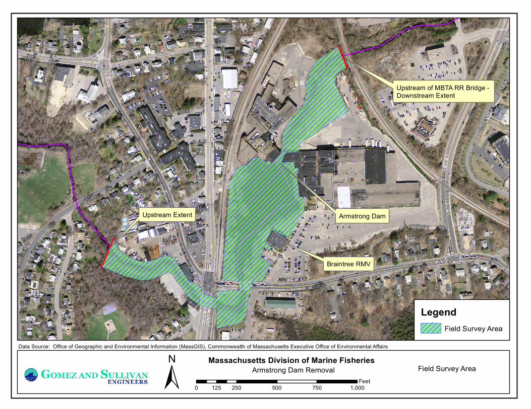
Armstrong Dam
Upstream of MBTA RR Bridge - Downstream Extent
Upstream Extent
Braintree RMV
±Data Source: Office of Geographic and Environmental Information (MassGIS), Commonwealth of Massachusetts Executive Office of Environmental Affairs
Massachusetts Division of Marine FisheriesArmstrong Dam Removal
0 250 500 750 1,000125Feet
Field Survey Area
LegendField Survey Area

LEC Environmental Consultants, Inc.
Plymouth, MA508.746.9491
www.lecenvironmental.com
Attachment B: Aerial Orthophoto with DEP Wetlands and NHESP Overlay ±Armstrong Dam Removal
Braintree, Massachusetts
0 500 1,000250Feet
LOCUS
July 29, 2016
2013 Aerial Orthophoto acquired from the Office of Geographic Information
(MassGIS) website.
Estimated Habitat of Rare Wildlife (2008)
Priority Habitat of Rare Species (2008)
DEP Wetlands

Wetland Resource Area Analysis: Photographs
Armstrong Dam Removal Project
Monatiquot River
Braintree, Massachusetts
Photograph 1: Southern view of Armstrong Dam
Photograph 2: Northern view of Monatiquot River from Armstrong Dam
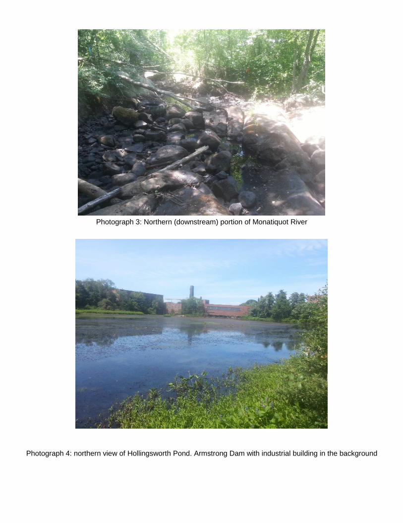
Photograph 3: Northern (downstream) portion of Monatiquot River
Photograph 4: northern view of Hollingsworth Pond. Armstrong Dam with industrial building in the background

Photograph 5: southern view of Hollingsworth pong. Plain Street Bridge in the background
Photograph 6: northern view of Monatiquot River flowing beneath Plain Street

Photograph 7: Southern view of the Monatiquot River immediately south of Plain Street
Photograph 8: Western view of Monatiquot River flowing beneath the Hancock Street Bridge
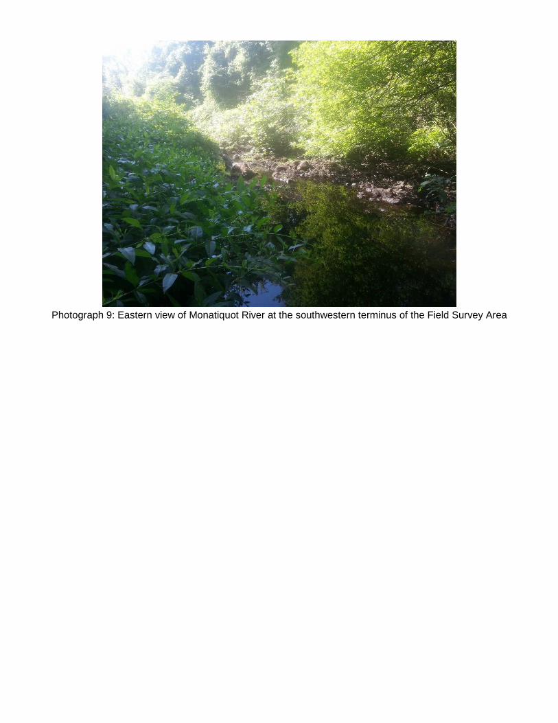
Photograph 9: Eastern view of Monatiquot River at the southwestern terminus of the Field Survey Area