Wetland City Accreditation Nomination Form City...Mogok-ri), Yueomyeon (Sejin-ri, Daedae-ri),...
30
Wetland City Accreditation Nomination Form Instruction for compilers: i. Complete all yellow cells taking into account the specific limits on characters. ii. Further information on the wise use of wetlands and cities is provided in Resolution XI.11 available at: http://www.ramsar.org/document/resolution-xi11-principles-for-the-planning-and- management-of-urban-and-peri-urban-wetlands;and on the Wetland City Accreditation process at: http://www.ramsar.org/document/resolution-xii10-wetland-city-accreditation-of-the-ramsar- convention. iii. Completed Nomination Forms should be sent by the designated National Focal Point for Ramsar Convention matters in the Administrative Authority to: [email protected] iv. Further guidance on how to compile the Nomination Form is available at: http://www.ramsar.org/ 1. Background information Notes 1a. Country Republic of Korea 1b. Name of city Changnyeong County, South Gyeongsang Province including Daehapmyeon (Soya-ri, Toisan-ri, Sindang-ri, Jumae- ri), Yibangmyeon (An-ri, Chogok-ri, Dongsan-ri, Okcheon-ri, Mogok-ri), Yueomyeon (Sejin- ri, Daedae-ri), Daejimyeon (Changsan-ri, Boncho-ri) An eligible ‘city’ for the Wetland City Accreditation may be a city or any other type of human settlement according to the definition given by United Nations Centre for Human Settlement 1c. Geographical coordinates of the city 35°33'N, 128°25'E 1d. Administrative and wetland map See Attachment 1d Provide a map delineating the administrative boundary of the city and indicating, as far as possible, all wetlands fully or partly situated in its territory or close vicinity 1e. Area of city 4,689ha Area within administrative boundary Page 1 / 30
Transcript of Wetland City Accreditation Nomination Form City...Mogok-ri), Yueomyeon (Sejin-ri, Daedae-ri),...

Wetland City Accreditation Nomination Form
Instruction for compilers: i. Complete all yellow cells taking into account the specific limits on characters. ii. Further information on the wise use of wetlands and cities is provided in Resolution XI.11 available at: http://www.ramsar.org/document/resolution-xi11-principles-for-the-planning-and-management-of-urban-and-peri-urban-wetlands;and on the Wetland City Accreditation process at: http://www.ramsar.org/document/resolution-xii10-wetland-city-accreditation-of-the-ramsar-convention. iii. Completed Nomination Forms should be sent by the designated National Focal Point for Ramsar Convention matters in the Administrative Authority to: [email protected] iv. Further guidance on how to compile the Nomination Form is available at: http://www.ramsar.org/
1. Background information
Notes 1a. Country Republic of Korea
1b. Name of city Changnyeong County, South Gyeongsang Province including Daehapmyeon (Soya-ri, Toisan-ri, Sindang-ri, Jumae-ri), Yibangmyeon (An-ri, Chogok-ri, Dongsan-ri, Okcheon-ri, Mogok-ri), Yueomyeon (Sejin-ri, Daedae-ri), Daejimyeon (Changsan-ri, Boncho-ri)
An eligible ‘city’ for the Wetland City Accreditation may be a city or any other type of human settlement according to the definition given by United Nations Centre for Human Settlement
1c. Geographical coordinates of the city
35°33'N, 128°25'E
1d. Administrative and wetland map
See Attachment 1d Provide a map delineating the administrative boundary of the city and indicating, as far as possible, all wetlands fully or partly situated in its territory or close vicinity
1e. Area of city 4,689ha Area within administrative boundary
Page 1 / 30

1f. Approximate area of wetlands within the city boundaries
Total: 2,192.6 ha (natural wetlands: 1,056.3 ha, artificial wetlands: 1,136.3ha)
Indication of the area of wetlands within the administrative boundaries, indicating, as far as possible, whether they are natural or human made
1.g Define the types of wetland present within the city boundaries
Permanent freshwater lake and marsh(O/Tp), rice paddy/irrigation canal (3), reservoir (2), ditch (N), stream (M)
Use the Ramsar Classification of wetlands to describe the range of wetland types. See http://www.ramsar.org/sites/default/files/documents/pdf/lib/hbk4-17.pdf (Annex I on Ramsar Classification System for Wetland Type)
Page 2 / 30

2. Accreditation criteria Instruction: To be considered for formal accreditation the city must satisfy ALL the following. Please provide all necessary information in the yellow cells. Please note that the word limits will be strictly enforced. In addition, compilers may provide attached files or web-links to specific examples, plans, regulatory instruments, relevant reports, case studies or photographs etc.
Group A: Criteria based on delivering the conservation and wise use of wetlands A city can be considered for accreditation if it has one or more Ramsar Sites or other significant wetlands fully or partly situated in its territory or in its close vicinity, which provide(s) a range of ecosystems services to the city. A.1 Name any Ramsar Site
that is fully or partly in the city administrative boundaries
Upo Wetland (site no. 934) Use the official Ramsar Site name and number as described on the Ramsar Information Sheet (available on https://rsis.ramsar.org/). If none, state ’None’.
A.2 Name any other significant wetland that is fully or partly in the city administrative boundaries
Gahang Wetland, Pallak Wetland, Daehak Wetland, Daedae Rice Paddy Specify its legal conservation status
(national or local), if none state None.
A city can be considered for accreditation if it has adopted measures for conservation of wetlands and their services including biodiversity and hydrological integrity. A.3. A city can be considered for accreditation if it can demonstrate that development avoids degrading and destroying wetlands. Describe the national and/or local policy, legislative measures and regulatory instruments, urban management plans etc. that are in use by the city to proactively prevent the degradation and loss of wetlands.
(This field is limited to 2500 characters) National policy, legislative measures and regulatory instruments
All policies and regulations on wetland conservation and management in the Republic of Korea (hereafter Korea) are based on the Wetlands Conservation Act (enacted in 1999). Designation of wetland protection areas based on that Act is the most powerful regulation to prevent development on and degradation of wetlands. Upo Wetland, consisting of 4 sub-wetlands (Upo, Mokpo, Saji, and Jjokjibeol Wetlands), is the largest inland wetland in Korea and a habitat of 1,000 flora and fauna species. In order to conserve and manage such ecological values of the wetland systematically, Upo Wetland was designated as a Ramsar Site in 1998 and as the first national wetland protection area (860.9ha) in August, 1999. Any development plan within the radius of 300 meters from the wetland protection area must pass the Preliminary Environmental Impact Assessment. Once a wetland protection area is designated, the Ministry of Environment develops and implements a 5-year-term wetland management plan. The plan restricts construction or expansion of buildings, modification of land traits, actions that affect water level and volume, and poaching animals and collecting plants, in order to promote conservation and prevent degradation of wetlands. Also the wetland was designated as a Natural Reserve (national monument no. 524) for its values in 2011 based on the Cultural Heritage Protection Act, and two ministries established regulations on it. In order to prevent any disturbance to birds’ foraging caused by fishery at Upo Wetland, the
Page 3 / 30

Ministry of Environment has implemented the policy since 2009 to pause fishery during winter (November to February) when migratory birds come and to compensate fishermen’s loss due to the pause. Also since 2014, the Ministry has prohibited entry into the ecologically most important area of Upo Wetland and entry of vehicles into the wetland area. Only permitted fishermen can access to the water to catch fish. (Nakdong River Basin Environmental Office Notification 2013-12). There is also ‘Biodiversity Management Contract System’ through which locals are asked to create rice paddies and leave rice straws to secure places for migratory birds to stay and the government is to compensate the locals for following the system. Local policy, legislative measures and regulatory instruments South Gyeongsang Provincial Hall, which includes Changnyeong County, developed ‘Master Plan for Upo Wetland Conservation and Restoration’ in 2007 and established related policies. The plan includes restoration and management plans, building a wetland center, local resident support programs, and raising fund for wetland environment. Later in 2009, ‘South Gyeongsang Province Act on Wetland Conservation and Management’ was enacted, which led to development and implementation of Wetland Conservation Action Plans (1st: 2009-2013, 2nd; 2014-2018) for all wetlands in the province. The action plan conducts assessment on each detailed task and in 2017, ‘South Gyeongsang Province Wetland Conservation Implementation Plan’ was developed to take necessary measures to conserve and manage wetlands at the local level. Agreement on wetland conservation made by the local community The local community has developed and observed ‘Changnyeong Community Agreement and Tourism Guidance on Upo Wetland’ to prevent degradation and loss of the wetland. <Attached photographs> A3-1. Wetlands Conservation Act A3-2. No Unauthorized Entry Sign A3-3. Biodiversity Management Contract System
A city can be considered for accreditation if it has implemented wetland restoration and/or management measures.
A.4. A city can be considered for accreditation if it can demonstrate that it proactively encourages the restoration or creation of wetlands as elements of urban, and especially water management infrastructure. Provide specific examples (site and summary of implemented measures) of where wetlands have been created or restored within the city as elements of urban infrastructure, such as to control flooding, cool climate, improve water quality, provide recreation, etc.
(This field is limited to 2500 characters) Restoration and recovery of ecological health of degraded wetland
The Ministry of Environment has purchased private land in the wetland protection and restoration area since 1998 in order to stop water pollution and habitat degradation caused by farming. Where there was once a field for onions and garlics (12,000m2) was purchased and restored by the government and now is a habitat for many species including Astragalus sinicus L. As a result of the restoration project, all estates have been purchased in the wetland restoration area, and 70% have been purchased in the wetland protection area. Efforts will continue to purchase the rest 30% and to restore the land. As a result, the water holding capacity of Upo Wetland increased to 24,068,000m3, which is 33% of annual outflow volume of nearby streams, and precipitation that emerges in the area, which is 89% of the entire basin area, flows into Upo Wetland directly, which prevents flood. Recently a project has been ongoing to create a habitat and feeding place (190,000m2) for crested ibises and other migratory birds to enhance the overall biodiversity of the wetland in a long term. The government will continue implement such projects in future. Designation of rice paddies near Upo as wetland restoration area
Page 4 / 30
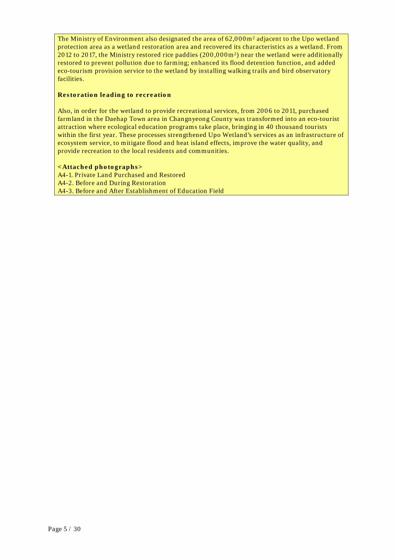
The Ministry of Environment also designated the area of 62,000m2 adjacent to the Upo wetland protection area as a wetland restoration area and recovered its characteristics as a wetland. From 2012 to 2017, the Ministry restored rice paddies (200,000m2) near the wetland were additionally restored to prevent pollution due to farming; enhanced its flood detention function, and added eco-tourism provision service to the wetland by installing walking trails and bird observatory facilities. Restoration leading to recreation Also, in order for the wetland to provide recreational services, from 2006 to 2011, purchased farmland in the Daehap Town area in Changnyeong County was transformed into an eco-tourist attraction where ecological education programs take place, bringing in 40 thousand tourists within the first year. These processes strengthened Upo Wetland’s services as an infrastructure of ecosystem service, to mitigate flood and heat island effects, improve the water quality, and provide recreation to the local residents and communities. <Attached photographs> A4-1. Private Land Purchased and Restored A4-2. Before and During Restoration A4-3. Before and After Establishment of Education Field
Page 5 / 30

A city can be considered for accreditation if it considers the challenges and opportunities of integrated spatial/land-use planning for wetlands under its jurisdiction. A.5. A city can be considered for accreditation if it can demonstrate that it considers the importance of wetlands within elements of spatial planning and integrated city management (such as through Integrated River Basin Management, spatial zonation, water resource management, the development of transport infrastructure, agriculture production, fuel supply, poverty alleviation, pollution control, flood risk management, disaster risk reduction, etc.). Describe the measures (policies, procedures, guidance, legislation, etc.) that ensure that the importance of wetlands is considered fully within elements of spatial planning and integrated city management.
(This field is limited to 2500 characters) Development and implementation of integrated management plan for the basic area
in consideration of characteristics of Upo Wetland In 2005, the Ministry of Land, Infrastructure, and Transport established a basic plan for Topyeong Stream, which flows through Upo Wetland. The plan is titled ‘Topyeong Stream Maintenance Basic Plan (Busan Regional Office of Construction Management, South Gyeongsang Province Notification 2005-186)’ and states that stream maintenance should be conducted in a way that does not ruin the wetland’s ecosystem and sceneries. According to the plan, other wetlands located in the mid-stream part of Topyeong Stream are to be utilized for flood detention and the detention areas of Mokpo Wetland and Sajipo Wetland are to remain at their current status in consideration of the impact of flood control plans on the wetland ecosystem. In this process, some part of Upo Wetland’s upper-stream was expanded in order to ensure smooth flow during flood. However, a survey confirmed that a dense cluster of willow trees in the lower-stream of Upo Wetland caused an uprising of the stream level during flood, and the fifth Upo Wetland Conservation Management Plan (2017-2021, Ministry of Environment) reflected this issue and provides a step-by-step guidance to eradicate the cluster so the wetland’s flood control service can improve and the landization of the wetland can be effectively controlled. Process of developing Stream Maintenance Basic Plan in consideration of Upo Wetland’s ecosystem When ‘Topyeong Stream Environment Maintenance Basic Plan’ was being developed, the text changed frequently to reflect Upo Wetland’s ecosystem. Some local residents demanded that the government build a drainage gate in the lower-stream of Topyeong Stream (where Upo Wetland and Nakdong River meet). The gate would certainly be effective in flood control but also accelerate landization, decrease the wetland area, and affect the biodiversity, overall damaging the ecological values of the wetland. For this reason, the demand was not accepted but reflected into a flood damage prevention project development, which includes back revetment and adding more drainage pump stations. Development and implementation of Urban Land Use Plan in consideration of pollution control Also the land use plan in ‘2030 Changnyeong County Basic Plan (2015)’ states that development in the Upo Wetland area is prohibited and that all areas within 300m of the wetland are proactively protected from development and degradation and pollution of wetland so that its ecological value will remain intact. Development of urban plan that considers ecological features of Upo Wetland and surrounding areas According to the county management plan, which is based on relevant laws on land plan and use, the nominated area for the Wetland City Accreditation (4,689ha) is categorized into conservation management areas, agricultural areas and forests, and planned management. Upo Wetland and its surrounding areas, taking up 32% (1,493.6ha) of the area of the nominated city for the accreditation, are designated as conservation management areas, which are subject to environment protection, forest protection, water pollution prevention, and green space
Page 6 / 30

protection. The rest areas are designated as agricultural areas and forests and planned management areas (residential areas) and managed accordingly. <Attached Photographs> A5-1. Topyeong Stream Maintenance Basic Plan A5-2. Usage District Map
A city can be considered for accreditation if it has delivered locally adapted information to raise public awareness about the values of wetlands, and encouraged the wise use of wetlands by stakeholders through, for example, establishing wetland eucation/information centres. A.6. A city can be considered for accreditation if it can demonstrate that it has adopted the principles of inclusivity, empowerment, and participation of indigenous and local communities and the civil society in decision-making and city planning and management. Describe how indigenous and local communities have been engaged and participate in the management of wetland-related issues.
(This field is limited to 2500 characters) Contribution to increased brand value of Upo Wetland
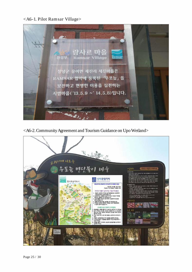
After the 10th Conference of the Parties to the Ramsar Convention (held in Changwon in October, 2008), the public awareness of Upo Wetland increased and Sejin Village of Changnyeong County decided through a village council meeting that the village be wetland-friendly and systematically conserving and wisely using the wetland. The Ministry of Environment designated the village as a pilot Ramsar village in 2013 and starting supporting the local community to conserve and manage the wetland independently, identify ways to use it wisely, and continue to enhance its services. 4 villages near the wetland are chosen as eco-tourism villages for their efforts for and achievements in wetland conservation. Also local residents formed ‘Changnyeong Council of Upo Wetland Ecotourism’, which runs educational programs on the values of the wetland and related local culture. Eventually the council contributes to the development of the community as well as the local economy. Village agreement made for Upo Wetland conservation and management The local community has developed ‘Changnyeong Community Agreement and Tourism Guidance on Upo Wetland’ along with the guidance on how to implement it, to authorize the community. This agreement and guidance were established in a council meeting on wetland conservation management. Operation of wetland ecology monitoring group and participation in trafficking illegal activities ‘Wetland Ecology Monitoring Group’ consisting of local residents, local rangers, and volunteers, covers 33 sections of Upo Wetland, trafficking activities that are illegal, polluting, or damaging the wetland. There is also ‘Upo Path of Life Monitoring Group’ that monthly patrols the trail called the Path of Life and inspects for damage to the wetland. The local community and government also work together twice a year to collect wastes in the wetland and surrounding areas. Facilitation of reviving endangered species ‘Changnyeong Upo Facilitation Council for Reviving Population of Crested Ibis’1) was founded in 2017, consisting of a representative of the local residents, related government organizations (Changnyeong Country Office and Nakdong River Basin Environmental Office), and NGOs, with the aim to protect Upo Wetland, which is the crested ibises’ habitat. The successful revival of crested ibis population is expected to encourage the rest of the county to actively participate in conservation and wise use of the wetland. 1) Around the time for the 10th Conference of the Parties to the Ramsar Convention, the
Page 7 / 30

government imported crested ibises (which was then extinct in Korea) from China to release them into Upo Wetland and to help them settle down and multiply. <Attached Photographs> A6-1. Pilot Ramsar Village A6-2. Community Agreement and Tourism Guidance on Upo Wetland A6-3. Environmental Purification Activities
A.7. A city can be considered for accreditation if it can demonstrate that it has raised levels of public awareness about the values of wetlands, and encouraged the wise use of wetlands by a diverse range of stakeholders and communities through, for example, establishing operational wetland education or information centres, regularly disseminating information on wetlands, establishing and implementing school education programmes, etc.
(This field is limited to 2500 characters) Operation of Upo Wetland Eco Center
Changnyeong County has operated Upo Wetland Eco Center since 2008 to provide information and education on the wetland’s ecological values to visitors and local students. In the Center are a VR room, an exhibition hall, view scopes, a theatre, and nature education hall. Curators offer field trip programs on wetland ecology. Around 60 thousand tourists visit the Center every year. Provision of Upo Wetland education program in the regular curriculum Upo Eco Education Center (http://upo.edcn.or.kr) operated by South Gyeongsang Province Office of Education conducts various programs on Upo Wetland including Upo Wetland field trip joined by 7,000 third-year students, the swallow ecological survey project joined by 100 elementary school student clubs, and the ecological field trip joined by 1,000 students and parents. Promotion, education, and participatory programs on biodiversity of Upo Wetland Organizations specializing in wetlands such as the Gyeongnam Ramsar Environmental Foundation have conducted monitoring on birds of Upo Wetland, amphibian conservation workshops, ecological surveys on swallows, and workshops for experts on improving ecological values of Upo Wetland as well as environmental campaigns such as feeding migratory events and World Wetlands Day celebrations. Also wet services have been operated for educational and informative purposes, such as Upo Wetland Cyber Eco-park (http://www.cng.go.kr/tour/upo.web) and Crested Ibises Restoration Center. <Attached Photographs> A7-1. Upo Wetland Eco Center A7-2. Upo Eco Education Center
A.8. A city can be considered for accreditation if it can demonstrate that it has proactively promoted events around World Wetlands Day (2 February) in order to raise awareness on wetlands and their importance to the city. Describe the types of events that have been delivered to celebrate World Wetlands Day in the city.
(This field is limited to 2500 characters) Participation in national events celebrating World Wetlands Day
The government has held ‘Civil and Governmental Expert Joint Workshop’ on each World Wetlands Day where public officers from the national and local governments, local communities, and experts share their achievements for the past year and discuss future wetland conservation management plans. Celebrations in wetlands have taken place sometime in May as February in Korea is too cold for outdoor events. Changnyeong County has participated in that celebration event each May to promote biodiversity of Upo Wetland and run field educational programs. In 2013, the county hosted ‘World Wetlands Day Celebration’ organized by the Ministry of Environment, inviting officers from the ministry, South Gyeongsang Province, Changnyeong
Page 8 / 30

County, and the National Wetlands Center and the local communities. The event consisted of seminars, promotional booths, and educational programs on wetlands. Organization of local events celebrating Wetlands Day In 2011, Changnyeong County designated the week of the Wetlands Day (in May) as ‘the Wetland Celebration Week’ in order to raise public awareness of the importance of wetland conservation, and has held the event where participants get a chance to watch and feed migratory birds in the Upo Wetland area. Since 2010, the county has co-hosted forums and seminars and migratory observation activities with South Gyeongsang Province and the Gyeongnam Ramsar Environmental Foundation, in order to promote the importance of wetland conservation to the public. <Attached Photographs> A8-1. Wetlands Week Promotional Booth A8-2. Wetlands Week Celebration Event
A city can be considered for accreditation if it has established a local committee with appropriate knowledge and experience on wetlands and demonstrates representation of and engagement with stakeholders to support the Wetland City accreditation, both through the submission of the Accreditation Form and the subsequent implementation of proper measures for fulfilling the obligations under the accreditation process. A.9. A city can be considered for accreditation if it can demonstrate that it has established a local committee (or similar structure) to support and to further the aims of the Wetland City Accreditation. Such a committee should contain appropriate knowledge and experience on wetlands and should be representative of stakeholders and communities. Describe the committee, its participants, mandate and operation.
(This field is limited to 2500 characters) Changnyeong Local Committee for Upo Wetland Management
Changnyeong County established Changnyeong Local Committee for Upo Wetland Management in 2016, which consists of 12 members each representing Nakdong River Basin Environmental Office, Changnyeong County, the resident council, experts, NGOs, South Gyeongsang Province Office of Education, a local elementary school (the principal), and the Gyeongnam Ramsar Environmental Foundation. The committee is also supported by Gyeongnam Culture and Arts Foundation and Korea Network on Rice Paddies as Wetlands who can facilitate various collaboration projects. The committee has operated various activities such as increasing public awareness, training wetland experts, leaning Upo Wetland, monitoring, eradicating alien species, managing habitats for migratory birds and monitoring them, and education and promotion on ecology. Activities of the local committee
The committee clarifies different roles and functions of each member for conservation, management, and wise use of Upo Wetland and promotes effective cooperation among the members. Nakdong River Basin Environmental Office is mainly in charge of degraded wetland restoration and monitoring along with the locals and ensuring the city will meet all the criteria to be accredited as a Wetland City of the Ramsar Convention. South Gyeongsang Province Office of Education, Changnyeong Education Support Office, and local schools are responsible for managing educational programs on rice paddies and the youth wetland reporter group. The role of the Gyeongnam Ramsar Environmental Foundation and Korea Network on Rice Paddies as Wetlands is monitoring migratory birds and survey on species living in rice paddies. Changnyeong Upo Wetland Eco-tourism Association led by the local community is serving as an operator of the committee and as a coordinator to assist the local community in fulfilling its duty to meet the criteria for the Wetland City Accreditation. <Attached Photographs>
Page 9 / 30
A9-1. Local Committee for Upo Wetland Management A9-2. Youth Wetland Reporter Group
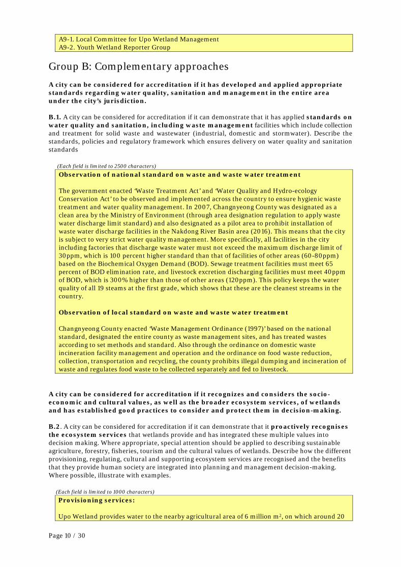
Group B: Complementary approaches A city can be considered for accreditation if it has developed and applied appropriate standards regarding water quality, sanitation and management in the entire area under the city’s jurisdiction. B.1. A city can be considered for accreditation if it can demonstrate that it has applied standards on water quality and sanitation, including waste management facilities which include collection and treatment for solid waste and wastewater (industrial, domestic and stormwater). Describe the standards, policies and regulatory framework which ensures delivery on water quality and sanitation standards
(Each field is limited to 2500 characters) Observation of national standard on waste and waste water treatment
The government enacted ‘Waste Treatment Act’ and ‘Water Quality and Hydro-ecology Conservation Act’ to be observed and implemented across the country to ensure hygienic waste treatment and water quality management. In 2007, Changnyeong County was designated as a clean area by the Ministry of Environment (through area designation regulation to apply waste water discharge limit standard) and also designated as a pilot area to prohibit installation of waste water discharge facilities in the Nakdong River Basin area (2016). This means that the city is subject to very strict water quality management. More specifically, all facilities in the city including factories that discharge waste water must not exceed the maximum discharge limit of 30ppm, which is 100 percent higher standard than that of facilities of other areas (60-80ppm) based on the Biochemical Oxygen Demand (BOD). Sewage treatment facilities must meet 65 percent of BOD elimination rate, and livestock excretion discharging facilities must meet 40ppm of BOD, which is 300% higher than those of other areas (120ppm). This policy keeps the water quality of all 19 steams at the first grade, which shows that these are the cleanest streams in the country. Observation of local standard on waste and waste water treatment Changnyeong County enacted ‘Waste Management Ordinance (1997)’ based on the national standard, designated the entire county as waste management sites, and has treated wastes according to set methods and standard. Also through the ordinance on domestic waste incineration facility management and operation and the ordinance on food waste reduction, collection, transportation and recycling, the county prohibits illegal dumping and incineration of waste and regulates food waste to be collected separately and fed to livestock.
A city can be considered for accreditation if it recognizes and considers the socio-economic and cultural values, as well as the broader ecosystem services, of wetlands and has established good practices to consider and protect them in decision-making. B.2. A city can be considered for accreditation if it can demonstrate that it proactively recognises the ecosystem services that wetlands provide and has integrated these multiple values into decision making. Where appropriate, special attention should be applied to describing sustainable agriculture, forestry, fisheries, tourism and the cultural values of wetlands. Describe how the different provisioning, regulating, cultural and supporting ecosystem services are recognised and the benefits that they provide human society are integrated into planning and management decision-making. Where possible, illustrate with examples.
(Each field is limited to 1000 characters) Provisioning services:
Upo Wetland provides water to the nearby agricultural area of 6 million m2, on which around 20
Page 10 / 30

thousand people’s living depends. 12 households who live near the wetland catch fishes of 30 tons a year and their living depends on it as well. In order to maintain such provision services, the county closed down a livestock farm to control the water quality of Topyeong Stream, which is the upper-stream of Upo Wetland, and limits the number of nets that each of the fishery households can set up at a time (5 fyke nets and 40 gill nets) to prevent overfishing. The county also offers annual education program to promote and expand environment-friendly agriculture complex to ensure the quality of the rice that grows in the rice paddies as wetlands near Upo Wetland.
Regulating services:
Flowing into Nakdong River, one of the five major rivers in Korea, Upo Wetland functions as a detention basin that reduces flood damage. The detention capacity of the wetland is 24,068,000m3 (33% of the annual outflow volume of the nearby stream), which can store 89% of floodwater in the region. Also the wetland contributes to water purification of the stream through its function to reduce nonpoint pollution source. Upo Wetland is also known for contributing to climate regulation and carbon absorption by reducing the regional temperature by 1 degree Celsius and absorbing methane.
Supporting services:
Upo Wetland functions as a habitat for various species. There are 730 wildlife species living in the wetland (81 phytoplankton species, 515 flora species, 29 fish species, 105 benthic invertebrate species, 55 aquatic insect species, 12 mammal species, 7 reptile species, 5 amphibian species, and 5 shellfish species). Among them, there are 8 endangered species including Euryale ferox and Cygnus Cygnus (nationally endangered). Also 213 bird species have been found in the wetland that functions as a wintering ground and habitat for migratory birds. In an effort to maintain such ecological services, the Ministry of Environment and Changnyeong County are developing a measure to reward for eradicating nutrias, basses, and bluegills, and also set the winter season (November to February) as a no-fishing period and compensate for resulting economic loss.
Cultural services:
The culture of the villages nearby Upo Wetland has been built around and upon the wetlands. As the people living near Upo Wetland have made a living by fishing, they have kept their traditions such as Pung-eoje (a ritual for big catches of fish). Also for centuries, they have sung a particular song when they plant rice in the field near the wetland. Upo Wetland’s unique scenery has been used as a background for movies including animation ‘Leafie, A Hen into the Wild (2011)’, a story of migratory birds coming to Upo Wetland. Upo Wetland is one of the major eco-tourist attractions having around 800 thousand visitors a year. The wetland is also an excellent model for ecology education. Upo Ecology Education Center is operated by South Gyeongsang Province Office of Education and is the only wetland education center run by the government. The center provides education on wetlands to around 20 thousand students, teachers, and parents annually. Upo Wetland Eco Center has on average 60 thousand visitors a year and Crested Ibis Restoration Center is visited by around 200 people every day. The local community has held a variety of festivals every year where people can experience the wetland-related culture. Upo Wetland takes the central role of the wetland eco-tourism network that vitalizes the local economy, linked to other regional icons such as cultural heritages, Mt. Hwawang, Nakdong River, and Bugok Hot-spring.
B.3. A city can be considered for accreditation if it can demonstrate that there is a close link between local communities and the wetlands. Describe how local communities are engaged with the wise use of wetlands and how the communities benefit from the services the wetlands provide.
(This field is limited to 2500 characters) For centuries, Upo Wetland has been essential in the lives of the people living nearby. They have
been provided with water for agriculture, fish for living, and resources for food. The people have also benefited from the wetland’s services to mitigate the heat island effect, to control pollutants,
Page 11 / 30

to detain flood from nearby streams, protecting people and prevent economic and social losses. The wetland also serves as a place for recreation and people can experience the ecology at first hand through tourist facilities. Some locals have taken ecology education programs offered by the county or NGOs and served as curators on Upo Wetland ecology or as environment rangers, working with pride and also getting paid. More and more locals sustain their living by doing business related to the wetland eco-tourism such as selling agricultural and manufactured products and running a restaurant or an accommodation. The foundation of Upo Ecology Education Center has resulted in broader education on wetland ecology. The local government and communities established the local management committee which seeks ways for wise use of the wetland and conducts cleaning activities, alien species eradication, and ecological monitoring.
Page 12 / 30

3. City approval Instruction: An authorised representative of the city authority making the application needs to check and approve the accreditation form against the guidance provided. In the case of several cities making a joint submission, a representative of each authority needs to check and approve the form, and then send it to the country’s Ramsar Administrative Authority who will formally submit it to the Ramsar Convention Secretariat ([email protected]) If more than three authorities are making the submission please insert further boxes. Name/Title: Choong-Sik KIM (Mr.)
Position: Governor of Changnyeong County
Address 1, Guncheong-gil, Changnyeong-eup, Changnyeong-gun, South Gyeongsang Province, Republic of Korea
E-mail [email protected]
Date: 2017. 9. 30 Signature:
4. Endorsement by the Ramsar Administrative Authority Instruction for the Ramsar Administrative Authority: Please check and endorse each application for City Accreditation in your country, before sending this form to the Ramsar Secretariat at ([email protected]).
Name of Administrative Authority
Nature and Ecology Policy Division, Ministry of Environment, Republic of Korea
Name and title of Designated National Focal Point for Ramsar Convention matters
Kwan-Sung SONG (Mr.), Deputy Director
Date: 2017.10.31
Signature of the Designated National Focal Point for Ramsar Convention matters:
Page 13 / 30

Annex – Attached Photographs
Wetland City Accreditation
Nomination Form
for
Changnyeong County
Attachments
Page 14 / 30

List
<1d. Map of Nominated City> ····································································································· 16
<A3-1. Wetlands Conservation Act> ······················································································· 17
<A3-2. No Unauthorized Entry Sign> ···················································································· 18
<A3-3. Biodiversity Management Contract System> ···················································· 19
<A4-1. Private Land Purchased and Restored> ······························································· 20
<A4-2. Before and During Restoration> ··············································································· 21
<A4-3. Before and After Establishment of Education Field> ·································· 22
<A5-1. Topyeong Stream Maintenance Basic Plan> ····················································· 23
<A5-2. Usage District Map> ······································································································· 24
<A6-1. Pilot Ramsar Village> ····································································································· 25
<A6-2. Community Agreement and Tourism Guidance on Upo Wetland> ·················· 25
<A6-3. Environmental Purification Activities> ······························································· 26
<A7-1. Upo Wetland Eco Center> ·····························································································27
<A7-2. Upo Eco Education Center> ························································································27
<A8-1. Wetlands Week Promotional Booth> ···································································· 28
<A8-2. Wetlands Week Celebration Event> ······································································ 28
<A9-1. Local Committee for Upo Wetland Management> ········································ 29
<A9-2. Youth Wetland Reporter Group> ············································································ 29
<Draft WCRC Poster for Upo Wetland> ··············································································· 31
Page 15 / 30

<1d. Map of Nominated City>
Page 16 / 30

<A3-1. Wetlands Conservation Act>
Page 17 / 30

<A3-2. No Unauthorized Entry Sign>
Page 18 / 30

<A3-3. Biodiversity Management Contract System>
Page 19 / 30

<A4-1. Private Land Purchased and Restored>
Page 20 / 30

<A4-2. Before and During Restoration>
Page 21 / 30

<A4-3. Before and After Establishment of Education Field>
Page 22 / 30

<A5-1. Topyeong Stream Maintenance Basic Plan>
(Established by Busan Regional Construction and Management Administration)
Page 23 / 30

<A5-2. Usage District Map>
Changnyeong-gun Ramsar Wetland City Usage area·Usage district Map
Page 24 / 30
<A6-1. Pilot Ramsar Village>
<A6-2. Community Agreement and Tourism Guidance on Upo Wetland>
Page 25 / 30

<A6-3. Environmental Purification Activities>
Page 26 / 30

<A7-1. Upo Wetland Eco Center>
<A7-2. Upo Eco Education Center>
Page 27 / 30

<A8-1. Wetlands Week Promotional Booth>
<A8-2. Wetlands Week Celebration Event>
Page 28 / 30

<A9-1. Local Committee for Upo Wetland Management>
<A9-2. Youth Wetland Reporter Group>
Page 29 / 30

<Draft WCRC Poster for Upo Wetland>
Page 30 / 30