WESTERN PORT WWOODLANDSOODLANDS
31
WESTERN PORT AUGUST 2021 Wildlife corridor or sand pit? WOODLANDS WOODLANDS
Transcript of WESTERN PORT WWOODLANDSOODLANDS

WESTERN PORT
A U G U S T
2021
Wildlife corridor or sand pit?
WOODLANDSWOODLANDS

Western Port Woodlands | PAGE 2 Western Port Woodlands | PAGE 3
Victorian National Parks Association An independent, non-profit, membership-based group, Victorian National Parks Association exists to protect Victoria’s unique natural environment and biodiversity through the establishment and effective management of national parks, including marine national parks, conservation reserves and other measures. VNPA works by facilitating strategic campaigns and education programs, developing policies, conducting hands-on conservation work, and by running bushwalking and outdoor activity programs which promote the care and enjoyment of Victoria’s natural heritage.
Victorian National Parks Association Level 3, 60 Leicester Street, Carlton, Victoria, 3053 Phone: 03 9341 6500Email: [email protected]: www.vnpa.org.au
Save Western Port Woodlands
Save Western Port Woodlands is a community group advocating for an end to sand mining in Bass Coast's rare coastal forests and woodlands. The group wants to see permanent protection of all reserves and remnant bushland in the Western Port forest corridor between Nyora and the Grantville Nature Conservation Reserve.
© Published by the Victorian National Parks Association August 2021. Licensed CC BY 3.0 AU
http://creativecommons.org/licenses/by-sa/3.0/au/
Acknowledgements
The analysis and report was prepared and written by Conor Logan, Hayley Forster, Robert Pergl, Matt Ruchel and Jordan Crook with guidance and local knowledge provided by Save Western Port Woodlands group.
Copy edited by Meryl Tobin and edited by Michael Howes.
Thank you to David Nicholls (Research Officer Southern Brown Bandicoot Regional Recovery Group), Meghan Lindsay (Cardinia Environment Coalition), John Kotsiaris, Terry Coates, Sapphire McMullan-Fisher, Irene Proebsting, Ricardo Simao, Woodrow Wilson Photography, Charlotte Fletcher, John Eichler, Hartley Tobin and Geoff Glare.
Traditional Owners
The Victorian National Parks Association and Save Western Port Woodlands acknowledge the many First Peoples of the area now known as Victoria, honour their continuing connection to, and caring for Country, and support Traditional Owner joint management of parks and public land for the conservation of natural and cultural heritage.
Disclaimer
VNPA is responsible for the content of the Western Port Woodlands: Wildlife corridor or sand pit?, an assessment of the threatened woodlands of Western Port including text, diagrams and recommendations. To the extent permitted by law, VNPA disclaims all liability in connection with any loss and/or damage, arising out of or in connection with the use of this report. Information is current at August 2021. VNPA has endeavoured to verify and acknowledge all sources, however please contact VNPA if any errors or omissions are identified.
Cover image: Grass-trees in October 2019. Photo by Hartley Tobin. Back cover image: Sand Mine on Bass Coast 2020. Photo by Catherine Wilson.
TABLE OF CONTENTS
List of Tables 4List of Maps 4Definitions and Abbreviations 5Key Findings 6Introduction 7
Site Location and Description 8
Gippsland Plains 8Study Site 8
History 11
Conservation Values 11
Ecological Vegetation Classes (EVCs) 12Threatened Species 15Threatened Fauna 16Threatened Fungi and Flora 20 Fungi 23 Flora 23Conservation Significance 23
Holden Proving Ground 23
History 23Ecological Vegetation Classes 24Threatened and Significant Fauna 26Threatened Flora 28Connectivity 29Summary 29
Key Species – Case Studies 30
Southern Brown Bandicoot (Eastern) (Isoodon obesulus obesulus) 30 Habitat requirements 30 Conservation Status and Threats 31 Records within the investigation area 31 Recommendations 32Tea-tree Fingers (Hypocreopsis amplectens) 33 Recommendations 34Green-striped Greenhood (Pterostylis chlorogramma) 35Powerful Owl (Ninox strenua) 36 Habitat requirements and diet 36 Conservation Status and Threats 37 Records within the investigation area 37 Recommendations 37
Threats to Biodiversity 38
Extractive Industry – Sand Mining 38Land Clearing 41Climate Change 41Invasive Species 42
Planning Schemes – Zoning, Overlays and Schedules 43
Zones 43 Overlays 46 Vegetation Protection Overlays 46 Significant Landscape Overlays 46 Environmental Significance Overlays 46
Trust for Nature 49
Statewide Conservation Plan 49Investigation Area Specifics 49
Community Advocacy 50
Campaign for a National Park – 1996 50Save the Holden Bushlands Campaign 51Petition – Protect Adams Creek NCR 51Grantville Grass-tree Forest 51
Conclusion 53
Recommendations 54
Key recommendations 54 Lang Lang to Grantville Wildlife Corridor 54 Protection of Native Vegetation 54 VinFast site, Former Holden Proving Ground 55Threatened species specific recommendations 55 Southern Brown Bandicoot (Eastern) (Isoodon obesulus obesulus) 55 Tea-tree Fingers (Hypocreopsis amplectens) 55 Powerful Owl (Ninox strenua) 55
References 56
PHO
TO: I
REN
E PR
OEB
STIN
G
Printed using 100% post-consumer recycled paper, non-toxic inks and 100% solar power.

Western Port Woodlands | PAGE 4 Western Port Woodlands | PAGE 5
List of Tables Table 1 List of reserves, other public land, vegetated and private land within investigation areaTable 2 List of EVCs currently present within the investigation areaTable 3 List of Threatened and significant faunal species recorded within the investigation areaTable 4 List of Threatened flora and fungi species recorded within the investigation areaTable 5 List of EVCs currently present within the VinFast/Holden Proving GroundTable 6 List of Threatened and Significant faunal species recorded within the VinFast/Holden Proving GroundTable 7 List of Threatened flora species recorded within the VinFast/Holden Proving Ground and surroundingsTable 8 List of vascular plant species that Tea-tree Fingers has been observed occupyingTable 9 Species associated with Green-striped GreenhoodTable 10 Zones found within the investigation area
List of MapsMap 1 Investigation area and bioregions reference mapMap 2a Historical extent (1750) of modelled EVCs within and surrounding investigation areaMap 2b Current extent of modelled EVCs within and surrounding investigation areaMap 3 Threatened fauna and flora recorded within the investigation areaMap 4a Threatened fauna records within the northern section of the investigation AreaMap 4b Threatened fauna records within the southern section of the investigation AreaMap 5a Threatened flora records within the northern section of the investigation AreaMap 5b Threatened flora records within the southern section of the investigation AreaMap 6 Current extant of modelled EVCs within and surrounding the VinFast/Holden Proving GroundMap 7 Threatened fauna and flora records within and surrounding the VinFast/Holden Proving GroundMap 8 Current extractive industry tenements and Extractive Industry Interest Areas (EIIA)Map 9 Planning scheme zones found across the investigation areaMap 10 Planning scheme overlays as found across the investigation areaMap 11 Environmental Significance Overlays (ESOs) within and surrounding the investigation areaMap 12 Public and Private land use/ land cover and management, including extractive industry tenements
Definitions and AbbreviationsALA Atlas of Living AustraliaBR Bushland ReserveCES Commissioner for Environmental Sustainability VictoriaCR Critically EndangeredDAWE Department of Agriculture, Water and the EnvironmentDD Data Deficient DELWP Department of Environment, Land, Water and PlanningDEPI Department of Environment and Primary Industries (currently known as DELWP)DSE Department of Sustainability and Environment (currently known as DELWP)EA Education AreaEIIA Extractive Industry Interest AreasEN EndangeredEPBC Act Environment Protection and Biodiversity Conservation Act 1999ESO Environmental Significance OverlayEVC Ecological Vegetation ClassFFG Act Flora and Fauna Guarantee Act 1988FZ Farming ZoneGM General MotorsGWZ Green Wedge ZoneICUN International Union for Conservation of NatureIPCC Intergovernmental Panel on Climate ChangeL ListedLCC Land Conservation CouncilLGA Local Government AreaNC Act Nature Conservation Act 1992 (QLD)NCR Nature Conservation ReserveNPW Act National Parks and Wildlife Act 1972 (SA)NT Near Threatened PAO Public Acquisition OverlayPCRZ Public Conservation and Resource ZoneRBGV Royal Botanic Gardens VictoriaRCZ Rural Conservation ZoneRL Rural Living ZoneRS Railway StationSAC Scientific Advisory CommitteeSERA Strategic Extractive Resource AreaSLO Significant Landscape Overlay TFN Trust for NatureTSA Act Threatened Species Conservation Act 1995 (NSW) VAGO Victorian Auditor-General's OfficeVBA Victorian Biodiversity AtlasVDI Victorian Department of InfrastructureVEAC Victorian Environmental Assessment CouncilVF/HPG VinFast/Holden Proving GroundVPP Victorian Planning ProvisionsVPO Vegetation Protection Overlay VROT Victorian Rare or Threatened listVU Vulnerable WA Work Authority
The investigation area within this report is on the land of the Bunurong people of the Kulin Nation. The Bunurong Land Council Aboriginal Corporation is the Registered Aboriginal Party for the area (Victorian Aboriginal Heritage Council 2019).
The Victorian National Parks Association and Save Western Port Woodlands acknowledge the many First Peoples of the area now known as Victoria, honour their continuing connection to, and caring for, Country, and support Traditional Owner joint management of parks and public land for the conservation of natural and cultural heritage.
Western Port Woodlands | PAGE 6 Western Port Woodlands | PAGE 7
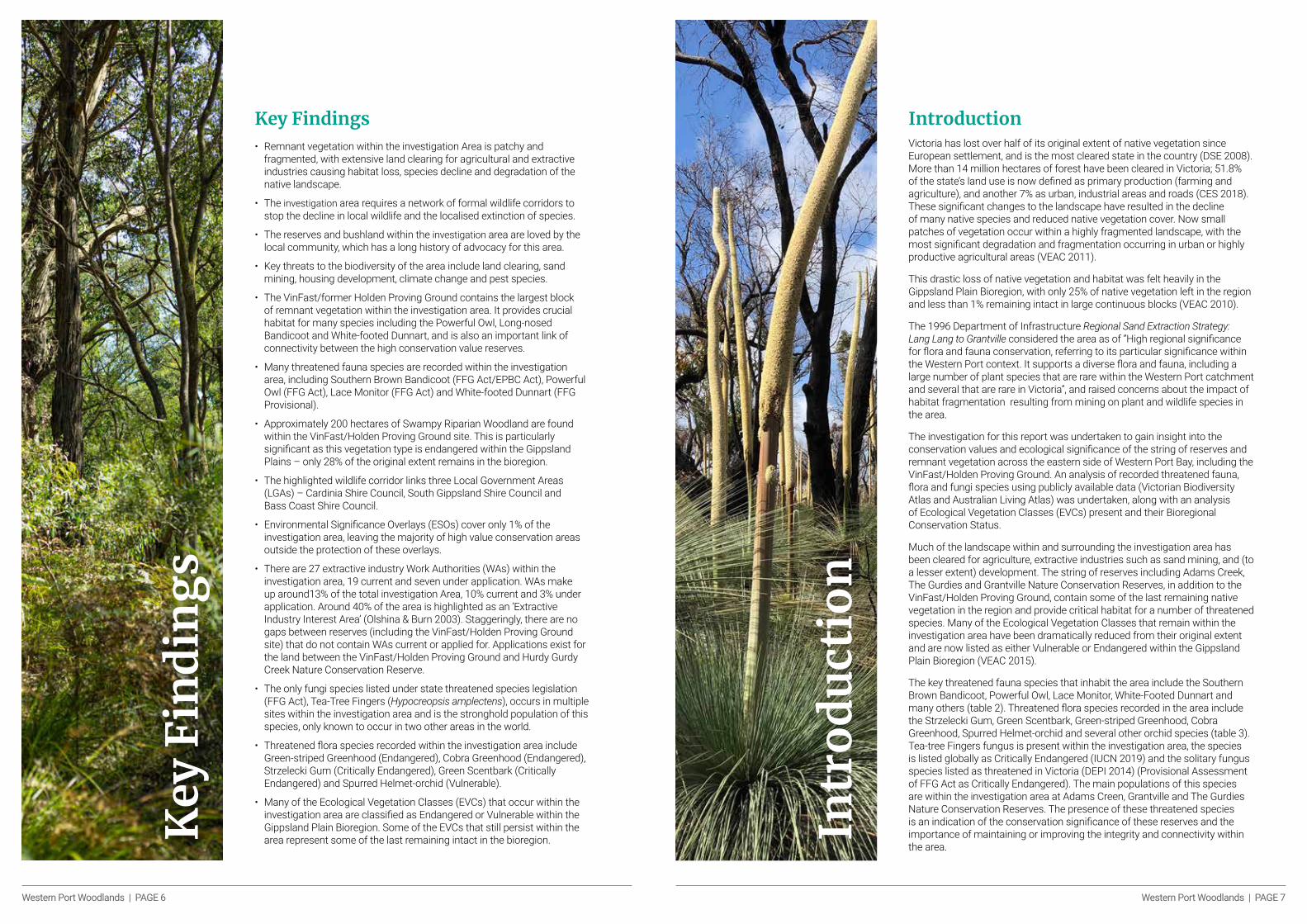
Key Findings • Remnant vegetation within the investigation Area is patchy and
fragmented, with extensive land clearing for agricultural and extractive industries causing habitat loss, species decline and degradation of the native landscape.
• The investigation area requires a network of formal wildlife corridors to stop the decline in local wildlife and the localised extinction of species.
• The reserves and bushland within the investigation area are loved by the local community, which has a long history of advocacy for this area.
• Key threats to the biodiversity of the area include land clearing, sand mining, housing development, climate change and pest species.
• The VinFast/former Holden Proving Ground contains the largest block of remnant vegetation within the investigation area. It provides crucial habitat for many species including the Powerful Owl, Long-nosed Bandicoot and White-footed Dunnart, and is also an important link of connectivity between the high conservation value reserves.
• Many threatened fauna species are recorded within the investigation area, including Southern Brown Bandicoot (FFG Act/EPBC Act), Powerful Owl (FFG Act), Lace Monitor (FFG Act) and White-footed Dunnart (FFG Provisional).
• Approximately 200 hectares of Swampy Riparian Woodland are found within the VinFast/Holden Proving Ground site. This is particularly significant as this vegetation type is endangered within the Gippsland Plains – only 28% of the original extent remains in the bioregion.
• The highlighted wildlife corridor links three Local Government Areas (LGAs) – Cardinia Shire Council, South Gippsland Shire Council and Bass Coast Shire Council.
• Environmental Significance Overlays (ESOs) cover only 1% of the investigation area, leaving the majority of high value conservation areas outside the protection of these overlays.
• There are 27 extractive industry Work Authorities (WAs) within the investigation area, 19 current and seven under application. WAs make up around13% of the total investigation Area, 10% current and 3% under application. Around 40% of the area is highlighted as an ‘Extractive Industry Interest Area’ (Olshina & Burn 2003). Staggeringly, there are no gaps between reserves (including the VinFast/Holden Proving Ground site) that do not contain WAs current or applied for. Applications exist for the land between the VinFast/Holden Proving Ground and Hurdy Gurdy Creek Nature Conservation Reserve.
• The only fungi species listed under state threatened species legislation (FFG Act), Tea-Tree Fingers (Hypocreopsis amplectens), occurs in multiple sites within the investigation area and is the stronghold population of this species, only known to occur in two other areas in the world.
• Threatened flora species recorded within the investigation area include Green-striped Greenhood (Endangered), Cobra Greenhood (Endangered), Strzelecki Gum (Critically Endangered), Green Scentbark (Critically Endangered) and Spurred Helmet-orchid (Vulnerable).
• Many of the Ecological Vegetation Classes (EVCs) that occur within the investigation area are classified as Endangered or Vulnerable within the Gippsland Plain Bioregion. Some of the EVCs that still persist within the area represent some of the last remaining intact in the bioregion.K
ey F
ind
ing
s
IntroductionVictoria has lost over half of its original extent of native vegetation since European settlement, and is the most cleared state in the country (DSE 2008). More than 14 million hectares of forest have been cleared in Victoria; 51.8% of the state’s land use is now defined as primary production (farming and agriculture), and another 7% as urban, industrial areas and roads (CES 2018). These significant changes to the landscape have resulted in the decline of many native species and reduced native vegetation cover. Now small patches of vegetation occur within a highly fragmented landscape, with the most significant degradation and fragmentation occurring in urban or highly productive agricultural areas (VEAC 2011).
This drastic loss of native vegetation and habitat was felt heavily in the Gippsland Plain Bioregion, with only 25% of native vegetation left in the region and less than 1% remaining intact in large continuous blocks (VEAC 2010).
The 1996 Department of Infrastructure Regional Sand Extraction Strategy: Lang Lang to Grantville considered the area as of “High regional significance for flora and fauna conservation, referring to its particular significance within the Western Port context. It supports a diverse flora and fauna, including a large number of plant species that are rare within the Western Port catchment and several that are rare in Victoria”, and raised concerns about the impact of habitat fragmentation resulting from mining on plant and wildlife species in the area.
The investigation for this report was undertaken to gain insight into the conservation values and ecological significance of the string of reserves and remnant vegetation across the eastern side of Western Port Bay, including the VinFast/Holden Proving Ground. An analysis of recorded threatened fauna, flora and fungi species using publicly available data (Victorian Biodiversity Atlas and Australian Living Atlas) was undertaken, along with an analysis of Ecological Vegetation Classes (EVCs) present and their Bioregional Conservation Status.
Much of the landscape within and surrounding the investigation area has been cleared for agriculture, extractive industries such as sand mining, and (to a lesser extent) development. The string of reserves including Adams Creek, The Gurdies and Grantville Nature Conservation Reserves, in addition to the VinFast/Holden Proving Ground, contain some of the last remaining native vegetation in the region and provide critical habitat for a number of threatened species. Many of the Ecological Vegetation Classes that remain within the investigation area have been dramatically reduced from their original extent and are now listed as either Vulnerable or Endangered within the Gippsland Plain Bioregion (VEAC 2015).
The key threatened fauna species that inhabit the area include the Southern Brown Bandicoot, Powerful Owl, Lace Monitor, White-Footed Dunnart and many others (table 2). Threatened flora species recorded in the area include the Strzelecki Gum, Green Scentbark, Green-striped Greenhood, Cobra Greenhood, Spurred Helmet-orchid and several other orchid species (table 3). Tea-tree Fingers fungus is present within the investigation area, the species is listed globally as Critically Endangered (IUCN 2019) and the solitary fungus species listed as threatened in Victoria (DEPI 2014) (Provisional Assessment of FFG Act as Critically Endangered). The main populations of this species are within the investigation area at Adams Creen, Grantville and The Gurdies Nature Conservation Reserves. The presence of these threatened species is an indication of the conservation significance of these reserves and the importance of maintaining or improving the integrity and connectivity within the area.
Intr
od
uct
ion

Western Port Woodlands | PAGE 8 Western Port Woodlands | PAGE 9
Site Location and Description Gippsland Plains
The Gippsland Plain Bioregion encompasses the eastern and south-eastern suburbs of Melbourne, the Mornington Peninsula, the surrounds of Western Port Bay and all along the south coast from Phillip Island to Bairnsdale, excluding the Strzelecki Ranges and Wilsons Promontory. The landscape includes flat to gradually undulating landscapes of coastal and alluvial plains, barrier dunes and swampy flats (Ecolink 2020) with most of the region comprising Cainozoic sediments (VicFlora 2020, Foreman 1993). There has been extensive land clearing and disturbance throughout the bioregion, mainly due to urbanisation and agriculture. The largely modified landscape has seen the loss of around three-quarters of the original extent of native vegetation, with less than 1% of the entire region remaining as ‘largely-intact landscape’ (VEAC 2011). Less than a quarter of the remnant vegetation occurs within conservation reserves; the remainder is within private land or other public land categories (VEAC 2011).
Study Site
The investigation area that is the subject of this report is based around the string of reserves, the former Holden Proving Ground and surrounding remnant vegetation located
on the east side of Western Port Bay. The reserves within the investigation area (from north to south) include Wuchatsch Reserve, Adams Creek Nature Conservation Reserve (NCR), Lang Lang Education Area (EA), Hurdy Gurdy Creek NCR, Bass Coast Shire Site, The Gurdies NCR, Grantville Bushland Reserve (BR), Colbert Creek BR, Corinella BR and Grantville NCR. The VinFast/Holden Proving Ground site, which contains the largest patch of remnant vegetation, is located centrally within the reserve network.
The investigation area was defined by existing reserves, the VinFast proving ground site also known as the former Holden Proving Ground, adjoining parcels containing significant vegetation cover (approx. >40% cover), and adjacent connecting land parcels. This final selection (reserves, VinFast/Holden Proving Ground, adjoining vegetation and connecting parcels) was buffered by 500 metres to the M420 highway as the boundary of the investigation Area (Map 1). The investigation area falls within three Local Government Areas (LGA): Shire of Cardinia, Shire of Bass Coast and Shire of South Gippsland (Map 1).
Much of this area was assessed by the Department of Infrastructure Regional Sand Extraction Strategy: Lang Lang to Grantville (1996). The report flagged concerns about the impact of sand mining on the integrity of habitat corridors and the risk of localised extinctions of plants and animals.
INSE
T PH
OTO
: BR
UC
E PR
ESTO
N, D
IGIT
ALLY
EN
HAN
CED
BY
GEO
RG
E PA
PAS
Table 1: List of reserves, other public land, vegetated and non-vegetated private land, their size in hectares, percentage of investigation area, tenure and land manager. (Please note the total investigation area as found in this table (12146.96 ha) is greater than the true investigation area ‘11983 ha’. This is due to imperfect overlap of spatial layers.
Reserve/Area Size (Ha) Percentage of Investigation Area (%)
Tenure Land Manager
Investigation Area 12146.96 100 N/A N/A
Adams Creek NCR 418.1 3.44 Nature Conservation Reserve Parks Victoria
Bass Coast Shire Site 52.3 0.43 Bass Coast Shire Bass Coast Shire
Colbert NCR 2.56 0.02 Nature ConservationReserve
Parks Victoria
Corinella BR 4 0.03 Bushland Reserve Parks Victoria
Grantville NCR 384.1 3.16 Nature Conservation Reserve Parks Victoria
VinFast/Holden Proving Ground
869.6 7.16 Private VinFast
Hurdy Gurdy Creek NCR 37.1 0.31 Nature ConservationReserve
Parks Victoria
Lang Lang EA 130.2 1.07 Education Area Parks Victoria
The Gurdies NCR 256.9 2.11 Nature Conservation Reserve Parks Victoria
Wuchatsch Reserve 15.2 0.13 Council Owned-TFN Covenant Land
South Gippsland Shire
Vegetated Private Land Parcels (80-100%)
1,087.40 8.52 N/A N/A
Partially Vegetated Land Parcels (20-80%)
2,889.50 23.79 N/A N/A
Non-vegetated Private Land Parcels (0-20%)
4,946.90 40.73 N/A N/A
Other Public lands Parcels 1,075.80 8.86 N/A N/A
PHO
TO: I
REN
E PR
OEB
STIN
G
Strzelecki Gum

Western Port Woodlands | PAGE 10 Western Port Woodlands | PAGE 11
Map 1: The investigation area (the subject of this report, outlined in red), containing the VinFast/Holden Proving Ground, formal and informal reserves and the Local Government Areas Bass Coast Shire, Shire of Cardinia and Shire of South Gippsland. The reference map includes the bioregions of Victoria.
HistoryThe Bunurong Land Council Aboriginal Corporation is the Registered Aboriginal Party for the area (Victorian Aboriginal Heritage Council, 2019). The Bunurong people have lived in the area for more than 40,000 years as part of the Kulin Nation (Mornington Peninsula Council, 2018) and hold on to their connection to country and culture through this area.
The densely vegetated Koo Wee Rup swamp was a major impediment to access into the region. Farmers suffered from frequent flooding and pressured the government to accept the enormous task of draining the swamp in the 1890s (LCC 1988). The drained swamp provided rich peat soils ideal for cropping and pasture in contrast to the more common and less suitable infertile sandy gravel soils in the investigation area. Hurdy Gurdy (16,000 acres) and Westerway, (7,680 acres) north-east of Corinella, selected in 1838, were among the first pastoral lease runs in the area (Grantville and District History 2018). Remaining areas remained undeveloped until timber cutters established a mill from which sawn timber was carried by a horse-drawn tramway to the Grantville Jetty in the early 1870s. Grantville seaport provided the major transport access until 1890 when the South Gippsland railway line was constructed (Monash University 2015a). McDonalds Track offered a route north of the present Adams Creek Nature Conservation Reserve between Lang Lang and Poowong, which provided greater access for farm selections in the 1870s around Nyora (Monash University 2015b). Nyora, Lang Lang and Grantville, all established in the 1880s, are the main service towns of the region (Monash University 2015a, b, c).Township settlements influenced land clearing, opening the area for farming and fragmenting native vegetation. Present native vegetation remnants occur predominantly on marginal land (VDI 1996).
The VinFast/Holden Proving Ground of 2,167 acres represents the largest block of remnant vegetation in the investigation area. Four separate adjacent land parcels were purchased and consolidated by General Motors in 1956 (Holden Retirees Club 2020). Engineers wanted land on which to run tests for GM Holden in controlled conditions where a range of road surfaces and gradients could be replicated. Two bisecting public road alignments were additionally purchased through the Lang Lang Land Act 1955. The land closest to the Bass Highway had been partially cleared at the time of sale, though with varying levels of regrowth (Holden Retirees Club 2020). In 2020 General Motors sold the land to the Vietnamese auto company VinFast, which has indicated it will continue to use the facility for developing new vehicles (GM Authority 2020).
The infertile soils unsuitable for farming were utilised for their mineral development potential. In the mid-1950s a sand washing plant was established inside the current The Gurdies NCR which later became a concrete plant (Donmix 2016). Sand and gravel extraction has occurred through the investigation area, later on with growing demand for concrete products (VDI 1996).
The former Land Conservation Council, a previous Victorian Government organisation that was the predecessor to the Victorian Environmental Assessment Council, undertook a systematic review of public land use (LCC 1988). It made a series of recommendations for current and future land use. Its recommendations for formal conservation protection were approved, and in the 1990s four large areas (Adams Creek, The Gurdies, Hurdy Gurdy and Grantville) were granted the status of Nature Conservation Reserves (VDI 1996).
In 1996 the former groups Bass Valley and District Branch of the South Gippsland Conservation Society, and the Coronet Ratepayers Association, proposed the creation of a new national park (Tobin, 2020). This would include the existing reserves Hurdy Gurdy Creek, The Gurdies, Colbert Creek, Grantville reserve and additional Crown land in the Grantville area. A petition with 1139 signatures was developed and handed to parliament. These groups were collectively advocating for the last major stands of pre-European native vegetation. The proposal was unsuccessful (Tobin 2020).
Conservation Values A detailed assessment of the flora, fauna and ecological vegetation classes was undertaken as part of this report. The presence or historical presence of vegetation and wildlife within the investigation area indicated a high level of conservation significance throughout the reserves, remnant vegetation and surroundings. Flora and fauna that have been recorded throughout the investigation area are listed as threatened with extinction, either nationally (EPBC Act) or in the state of Victoria (FFG Act).
The landscape east of Western Port Bay within the Gippsland Plain Bioregion is highly fragmented, with little native vegetation remaining. Remnant vegetation within the investigation area occurs in patches surrounded and disjointed by extensive land clearing for agricultural and extractive industries. The parks and reserves within the investigation area, with the addition of the VinFast/Holden Proving Ground and the surrounding vegetated patches of public land, contain most of the intact remnant native vegetation in the region.
Western Port Woodlands | PAGE 12 Western Port Woodlands | PAGE 13
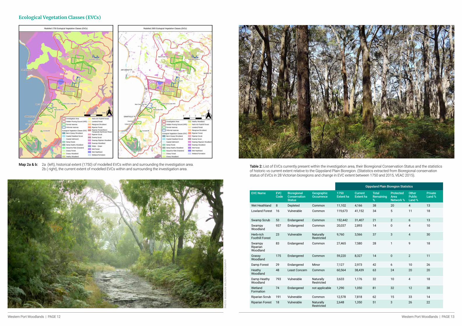
Ecological Vegetation Classes (EVCs)
Map 2a & b: 2a (left), historical extent (1750) of modelled EVCs within and surrounding the investigation area. 2b ( right), the current extent of modelled EVCs within and surrounding the investigation area.
PHO
TO: W
OO
DR
OW
WIL
SON
PH
OTO
GR
APH
Y
Table 2: List of EVCs currently present within the investigation area, their Bioregional Conservation Status and the statistics of historic vs current extent relative to the Gippsland Plain Bioregion. (Statistics extracted from Bioregional conservation status of EVCs in 28 Victorian bioregions and change in EVC extent between 1750 and 2015, VEAC 2015).
Gippsland Plain Bioregion Statistics
EVC Name EVC Code
Bioregional Conservation Status
Geographic Occurrence
1750 Extent ha
Current Extent ha
Total Remaining %
Protected Area Network %
Other Public Land %
Private Land %
Wet Heathland 8 Depleted Common 11,102 4,166 38 20 4 13
Lowland Forest 16 Vulnerable Common 119,673 41,152 34 5 11 18
Swamp Scrub 53 Endangered Common 152,442 31,407 21 2 6 13
Swampy Woodland
937 Endangered Common 20,037 2,893 14 0 4 10
Herb-rich Foothill Forest
23 Vulnerable Naturally Restricted
9,760 3,566 37 3 4 30
Swampy Riparian Woodland
83 Endangered Common 27,465 7,580 28 1 9 18
Grassy Woodland
175 Endangered Common 59,220 8,327 14 0 2 11
Damp Forest 29 Endangered Minor 7,127 2,973 42 6 10 26
Heathy Woodland
48 Least Concern Common 60,564 38,439 63 24 20 20
Damp Heathy Woodland
793 Vulnerable Naturally Restricted
3,633 1,176 32 10 4 18
Wetland Formation
74 Endangered not applicable 1,290 1,050 81 32 12 38
Riparian Scrub 191 Vulnerable Common 12,578 7,818 62 15 33 14
Riparian Forest 18 Vulnerable Naturally Restricted
2,648 1,350 51 3 26 22

Western Port Woodlands | PAGE 14 Western Port Woodlands | PAGE 15
Extensive land clearing throughout the bioregion has resulted in depleted Ecological Vegetation Classes (EVCs) within the Gippsland Plains. When comparing modelled EVCs from 1750 (Map 2a) with current extent remaining (Map 2b) it is apparent that the native vegetation within the investigation area has been greatly diminished and modified, much of the remaining intact vegetation confined to reserves and the VinFast/Holden Proving Ground. The vegetation that remains outside these reserves is predominantly Lowland Forest, Herb-rich Foothill Forest, Swampy Woodlands and Heathy Woodlands (Map 2b). These unprotected remaining patches offer valuable connectivity between reserves.
The predominant EVCs present throughout the investigation area include Heathy Woodlands, Lowland Forest, Riparian Scrub, Swampy Riparian Woodland, Grassy Woodland, Herb-rich Foothill Forest and Damp Heathy Woodlands, with many other EVCs represented in smaller portions across the area (Map 2b). Many of these EVCs have high significance in the Gippsland Plains, most being classified as either Vulnerable or Endangered within the bioregion (table 2).
Some of the EVCs in the investigation area have less than 30% remaining of their original extent within the Gippsland Plains. Swamp Scrub has only 21% remaining, Swampy Woodland and Grassy Woodland both have as little as 14% remaining, and Swampy Riparian Woodland has only 28% of its original extent (Table 2). These EVCs are poorly represented within protected reserves, 2% or less of their extent occurring within the reserves system in the Gippsland Plains. Of the four Endangered EVCs mentioned, Swampy Riparian Woodlands, Grassy Woodlands and Swampy Woodlands were previously prominent throughout the investigation Area (Map 2a). But although now heavily depleted (Map 2b), the remnants continue to provide critical ecological and habitat values within the ecosystems.
There are a number of significant large patches of Lowland Forest, Swampy Riparian Woodland and Heathy Woodland on private land situated between the reserves. Much of the remaining Lowland Forest and Swampy Riparian Woodlands in the Gippsland Plains occur on private land, little being represented within protected areas (Table 2). This indicates the importance of retaining these large patches across this landscape to both maintain connectivity and sustain the presence of those particular EVCs.
PHO
TO: W
OO
DR
OW
WIL
SON
PH
OTO
GR
APH
Y
Threatened Species
Map 3: Threatened fauna (triangles) and flora & fungi (circles) recorded within the investigation area, listed under the EPBC Act, FFG Act, or Victorian Rare or Threatened list (VROT). Records sourced from the VBA and ALA.

Western Port Woodlands | PAGE 16 Western Port Woodlands | PAGE 17
Threatened Fauna
Map 4a: Threatened fauna records within the Northern section of the investigation area, including Adams Creek NCR, VinFast/Holden Proving Ground, Lang Lang EA and Wuchatsch Reserve. Records sourced from the VBA and ALA.
Map 4b: Threatened fauna records within the Southern section of the investigation area including Colbert Creek BR, Corinella BR, The Gurdies NCR, Bass Coast Shire Site, Hurdy Gurdy Creek NCR, Grantville BR and Grantville NCR. Records sourced from the VBA and ALA.
Western Port Woodlands | PAGE 18 Western Port Woodlands | PAGE 19
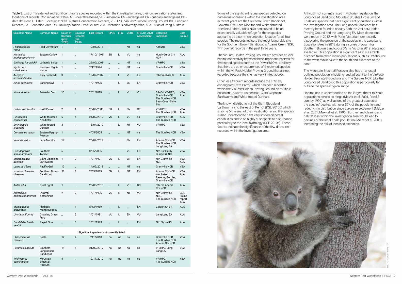
Table 3: List of Threatened and significant fauna species recorded within the investigation area, their conservation status and locations of records. Conservation Status; NT - near threatened, VU - vulnerable, EN - endangered, CR - critically endangered, DD - data deficient, L - listed. Locations: NCR - Nature Conservation Reserve, VF/HPG - VinFast/Holden Proving Ground, BR - Bushland Reserve, EA - Education Area, RS - Railway Station. Data Source; VBA - Victorian Biodiversity Atlas, ALA - Atlas of living Australia.
Scientific Name Common Name Count of Records (post 1990)
Count of Records (pre 1990)
Last Record EPBC FFG VROT FFG Act 2020 Assessment
Detection Locations
Data Source
Phalacrocorax varius
Pied Cormorant 1 _ 10/01/2018 _ _ NT na Almurta VBA
Numenius madagascariensis
Eastern Curlew 1 _ 17/10/1993 EN L VU na Hurdy Gurdy Crk NCR
ALA
Gallinago hardwickii Latham's Snipe 1 _ 26/09/2008 _ _ NT na VF/HPG VBA
Nycticorax caledonicus
Nankeen Night-Heron
1 _ 7/12/1994 _ _ NT na Grantville NCR VBA
Accipiter novaehollandiae
Grey Goshawk 3 _ 18/02/2007 _ L VU EN Sth Grantville BR ALA
Ninox connivens Barking Owl 1 _ 1/01/1995 _ L EN EN Grantville NCR VBA
Ninox strenua Powerful Owl 10 _ 2/01/2019 _ L VU VU Sth-Est VF/HPG, Grantville NCR, The Gurdies NCR, Bass Coast Shire Site
VBA, ALA
Lathamus discolor Swift Parrot 2 1 26/09/2008 CR L EN CR VF/HPG, The Gurdies NCR
VBA, ALA
Hirundapus caudacutus
White-throated Needletail
6 4 24/02/2019 VU L VU na Grantville NCR, The Gurdies NCR
ALA
Sminthopsis leucopus
White-footed Dunnart
3 _ 13/04/2012 _ L NT VU VF/HPG VBA
Cercartetus nanus Eastern Pygmy-Possum
1 _ 4/05/2005 _ _ NT na The Gurdies NCR VBA
Varanus varius Lace Monitor 17 _ 25/02/2019 _ _ EN EN Adams Crk NCR, The Gurdies NCR, Lang Lang EA
VBA
Pseudophryne semimarmorata
Southern Toadlet
6 _ 3/05/2005 _ _ VU EN Nth-Est Hurdy Gurdy Crk NCR
VBA
Megascolides australis
Giant Gippsland Earthworm
1 2 1/01/1991 VU L EN EN Nth Grantville NCR
VBA, ALA
Larus pacificus Pacific Gull 10 _ 14/02/2018 _ _ NT na Grantville NCR VBA
Isoodon obesulus obesulus
Southern Brown Bandicoot
51 8 2/05/2019 EN L NT EN Adams Crk NCR, Wuchatsch Reserve, Gurdies, Grantville NCR
VBA, ALA
Ardea alba Great Egret 1 _ 23/08/2013 _ L VU DD Sth-Est Adams Crk NCR
ALA
Antechinus minimus maritimus
Swamp Antechinus
2 2 1/01/1996 VU L NT VU Nth Grantville NCR, The Gurdies NCR
GGR Fauna report, ALA
Mugilogobius platynotus
Flatback Mangrovegoby
_ 1 5/12/1989 _ L _ EN Colbert Ck BR ALA
Litoria raniformis Growling Grass Frog
_ 2 1/01/1981 VU L EN VU Lang Lang EA ALA
Candalides heathi heathi
Rayed Blue _ 3 1/01/1973 _ L _ EN Nth Nyora RS ALA
Significant species - not currently listed
Phascolarctos cinereus
Koala 12 4 7/11/2018 na na na na Grantville NCR, The Gurdies NCR, Adams Crk NCR
VBA
Perameles nasuta Southern Long-nosed Bandicoot
11 1 21/09/2012 na na na na VF/HPG, Lang Lang EA
VBA
Trichosurus cunninghami
Mountain Brushtail Possum
9 _ 12/11/2012 na na na na VF/HPG, The Gurdies NCR
VBA
Some of the significant fauna species detected on numerous occasions within the investigation area in recent years are the Southern Brown Bandicoot, Powerful Owl, Lace Monitor and White-throated Needletail. The Gurdies NCR has proved to be an exceptionally valuable refuge for these species, appearing as a common detection location for all four species. The records indicate the most favourable site for the Southern Brown Bandicoot is Adams Creek NCR, with over 20 records in the past three years.
The VinFast/Holden Proving Ground site provides crucial habitat connectivity between these important reserves for threatened species such as the Powerful Owl. It is likely that there are other occurrences of threatened species within the VinFast/Holden Proving Ground that are not recorded because the site has very limited access.
Other less frequent records include the critically endangered Swift Parrot, which has been recorded within the VinFast/Holden Proving Ground on multiple occasions, Swamp Antechinus, Giant Gippsland Earthworm and White-footed Dunnart.
The known distribution of the Giant Gippsland Earthworm is to the east of Kernot (DSE 2010c) which is some 5 km east of the investigation area. The species is also understood to have very limited dispersal capabilities and to be highly susceptible to disturbance, particularly to the local hydrology (DSE 2010c). These factors indicate the significance of the few detections recorded within the investigation area.
Although not currently listed in Victorian legislation, the Long-nosed Bandicoot, Mountain Brushtail Possum and Koala are species that have significant populations within the investigation area. The Long-nosed Bandicoot has recently been found to occupy both the VinFast/Holden Proving Ground and the Lang Lang EA. Most detections were made in 2012, with Parks Victoria more recently discovering the presence of the species in the Lang Lang Education Area in 2019 during a survey program for Southern Brown Bandicoots (Parks Victoria 2019) (data not available). This population is significant as it is a sizable distance from other known populations such as Cranbourne to the west, Walkerville to the south and Allambee to the east.
The Mountain Brushtail Possum also has an unusual outlying population inhabiting land adjacent to the VinFast/Holden Proving Ground site and The Gurdies NCR. Like the Long-nosed Bandicoot, this population is particularly far outside the species’ typical range.
Habitat loss is understood to be the largest threat to Koala populations across its range (Melzer et al. 2001, Reed & Lunney 1990) as well as one of the greatest causes of the species’ decline, with over 50% of the population and reduction in distribution since European settlement (Melzer et al. 2001, Maxwell et al. 1996). Further land clearing and habitat loss within the investigation area would lead to declines of the local Koala population (Melzer et al. 2001), increasing the risk of localised extinction.
PHO
TO: H
AYLE
Y FO
RST
ER
Western Port Woodlands | PAGE 20 Western Port Woodlands | PAGE 21
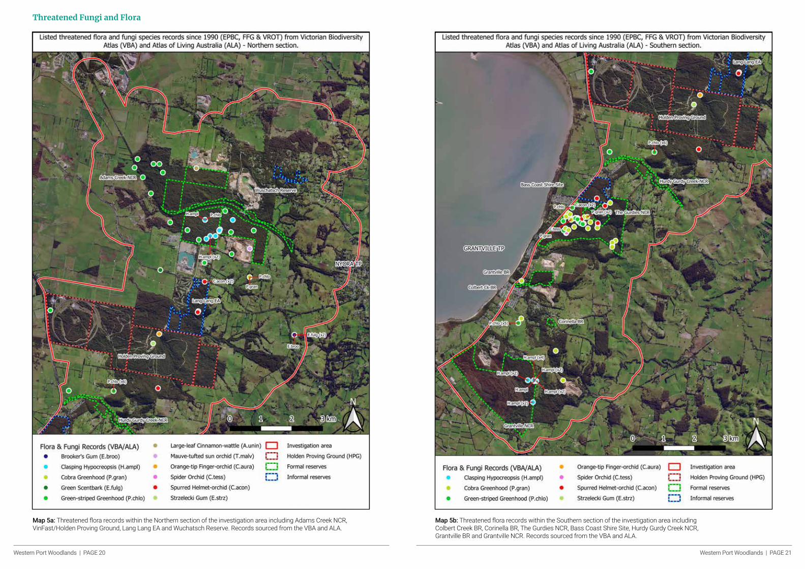
Threatened Fungi and Flora
Map 5a: Threatened flora records within the Northern section of the investigation area including Adams Creek NCR, VinFast/Holden Proving Ground, Lang Lang EA and Wuchatsch Reserve. Records sourced from the VBA and ALA.
Map 5b: Threatened flora records within the Southern section of the investigation area including Colbert Creek BR, Corinella BR, The Gurdies NCR, Bass Coast Shire Site, Hurdy Gurdy Creek NCR, Grantville BR and Grantville NCR. Records sourced from the VBA and ALA.

Western Port Woodlands | PAGE 22 Western Port Woodlands | PAGE 23
Table 4: List of Threatened flora and fungi species recorded within the investigation area, their conservation status and locations of records. Conservation Status; NT - near threatened, VU - vulnerable, EN - endangered, CR - critically endangered, R - rare, L - listed. Locations; NCR - Nature Conservation Reserve, VF/HPG - VinFast/Holden Proving Ground, BR - Bushland Reserve, EA - Education Area, RS - Railway Station. Data Source; VBA - Victorian Biodiversity Atlas, ALA - Atlas of Living Australia.
Scientific Name Common Name Count of Records (post 1990)
Count of Records (pre 1990)
Last Record EPBC FFG VROT FFG Act 2020 Assessment
Locations Data Source
Caladenia aurantiaca
Orange-tip Finger-orchid
1 _ 6/10/1995 _ _ R EN VF/HPG ALA
Corybas aconitiflorus
Spurred Helmet-orchid
10 1 13/07/2018 _ _ R VU The Gurdies NCR, Lang Lang EA, Bass Coast Shire Site
ALA
Pterostylis grandiflora
Cobra Greenhood
28 6 18/05/2020 _ _ R EN The Gurdies NCR, Grantville NCR
VBA, ALA
Eucalyptus strzeleckii
Strzelecki Gum 1 _ 22/03/2001 VU L VU CR VF/HPG VBA
Pterostylis chlorogramma
Green-striped Greenhood
25 1 8/07/2009 VU L VU EN The Gurdies NCR, Adams Ck NCR, Nth Hurdy Gurdy Crk NCR
VBA, ALA
Acacia leprosa var. uninervia
Large-leaf Cinnamon-wattle
1 _ 12/05/2005 _ _ R EN Adams Ck NCR VBA
Hypocreopsis amplectens
Tea-tree Fingers/ Clasping Hypocreopsis
23 _ 28/11/2019 _ L VU CR Grantville NCR, Adams Ck NCR
VBA, ALA
Caladenia tessellata
Spider Orchid 6 1 10/10/2017 VU _ vu EN The Gurdies NCR ALA
Eucalyptus brookeriana
Brooker's Gum 1 _ 20/11/1993 _ _ R EN East Lang Lang EA
ALA
Eucalyptus fulgens
Green Scentbark
3 _ 26/02/2019 _ _ R CR Along South Gippsland Highway
ALA
Thelymitra malvina
Mauve-tufted sun orchid
1 _ 10/11/1995 _ _ VU EN Sth Adams Ck NCR
ALA
Avicennia marina subsp. australasica
Grey Mangrove _ 1 3/01/1964 _ _ R EN Nth Grantville NCR
ALA
Fungi
Clasping Hypocreopsis or Tea-tree Fingers (Hypocreopsis amplectens) is a threatened fungus species that is recorded in just four sites across the Yarra Valley and West Gippsland in Victoria (RBGV 2020). This species occurs within the investigation Area, with records at Adams Creek and Grantville NCRs.
Flora
Within this string of reserves, and particularly The Gurdies NCR, there are a number of strongholds for several rare or endangered native orchid species such as the Green Striped Greenhood (Pterostylis chlorogramma), Cobra Greenhood (Pterostylis grandiflora) and the Spurred Helmet Orchid (Corybas aconitiflorus). The population of Green-striped Greenhoods in The Gurdies NCR is one of the two largest populations throughout the species’ range, with an estimate of roughly 100 plants present within an area of 20 hectares (DSE 2010b). The three main stands of Green-striped Greenhoods present within the investigation area (The Gurdies NCR, Lang Lang EA, and a stand in Grantville on private property) make up a large portion of the overall population of this nationally vulnerable species.
The Strzelecki Gum (Eucalyptus strzeleckii) and Green Scentbark (Eucalyptus fulgens) species are also listed taxa recorded within the investigation area as both species have recently been assessed and upgraded to Critically Endangered (pending approval) in the FFG Act Conservation Status Assessment project (DELWP 2020).
Conservation Significance
Given the highly degraded and fragmented landscape, the remaining intact areas of native vegetation in the investigation area have become extremely significant
for the survival of many native species in the general area. Unfortunately, the impacts of habitat loss for some species in the region may be continual, with further declines expected, even in the absence of additional habitat loss, as a result of ‘extinction debt’ (MacHunter et al. 2006). A study on the persistence of native fauna species found that in the Bass Coast, South Gippsland and islands region around two-thirds of both mammal and bird species have a higher probability of local extinction than of continued persistence (Caryl et al. 2008).
Small to medium sized ground-dwelling mammals like the Southern Brown Bandicoot and Swamp Antechinus are understood to have endured some of the greatest human-influenced impacts causing range reduction and overall species decline (Van der Ree & McCarthy 2005), in this instance largely through habitat loss to pastoral or agricultural landscapes and hyper-predation from introduced species such as the Red Fox (Smith & Quin 1995). These species are confined to habitat that remains, segregated from other populations, and increasingly exposed to edge effects (Haila et al. 1993, New 2000, Paull 2003).
As a result of habitat loss and fragmentation of remnant vegetation, this region has seen losses in biodiversity and disruption to the once highly diverse ecosystems. Native flora and fauna are predicted to decline further if remaining intact habitat is further degraded (Caryl et al. 2008). Improved connectivity and habitat restoration provide unique future opportunities for biodiversity conservation. Better connectivity between reserves can offer habitat corridors and prevent localised extinctions. This could enhance genetic diversity of populations and increase the opportunity for population growth (Mills & Allendorf 1996).
Holden Proving GroundThe former Holden Proving Ground now VinFast site represents the largest block of remnant vegetation in the investigation area, with four connecting land parcels totalling 869.6 hectares. Situated centrally within the string of reserves between Lang Lang EA and Hurdy Gurdy Creek NCR, the property provides crucial connectivity of native vegetation and supports suitable habitat for threatened species such as the Powerful Owl and Swift Parrot. The property has been fenced off for over 60 years in order to keep Holden’s practices private and keep out journalists (Save the Holden Bushlands 2020). However, the fence has also provided protection from introduced predator species such as foxes and cats, allowing the native species present within the grounds to thrive. The maintained privacy of the property has also protected the vegetation from other disturbances caused by recreational activities and human interference.
History of the former Holden Proving Ground
Four separate adjacent land parcels were purchased and consolidated by General Motors in 1956 (Holden Retirees Club 2020). Engineers wanted land to run tests for Holden's vehicles in controlled conditions where a range of road surfaces and gradients could be replicated. Two bisecting public road alignments were additionally purchased through the Lang Lang Land Act 1955. The land closest to Bass Highway had been partially cleared at the time of sale with varying levels of regrowth (Holden Retirees Club 2020). In 2020 General Motors sold the land to Vietnamese auto start-up company VinFast with indications it will continue to use the facility for developing new vehicles (GM Authority 2020). A strong campaign by members of the community encouraged the state government to protect the Holden Proving Ground for its importance as a wildlife corridor for local wildlife (Dowling 2020).

Western Port Woodlands | PAGE 24 Western Port Woodlands | PAGE 25
Ecological Vegetation Classes within the VinFast/Holden Proving Ground
Map 6: The current extent of modelled EVCs within and surrounding the VinFast/Holden Proving Ground.
Table 5: List of EVCs present within the VinFast/Holden Proving Ground and their Bioregional Conservation Status.
Six different Ecological Vegetation Classes (EVC) make up the landscape within the VinFast/Holden Proving Ground. Heathy Woodland encompasses large portions of the property and there is a significant amount of Swampy Riparian Woodland, Riparian Scrub and Wet Heathland, mostly around the north-western and central areas. The riparian vegetation within the VinFast/Holden Proving Ground represents some of the most extensive areas of this vegetation type across the entire string of remnant native vegetation in the investigation area. These areas are often an important habitat requirement for many species,
particularly of for birds such as the Powerful Owl. The dense tree cover and complex mid-storey offer ideal foraging and roosting habitat which may be absent from non-riparian vegetation types (Palmer and Bennett 2005).
The approximate 200 hectares of Swampy Riparian Woodland in the VinFast/Holden Proving Ground are particularly significant, as this EVC is Endangered within the Gippsland Plains with only 28% of the original extent remaining in the bioregion (VEAC 2015).
EVC Name EVC Code Bioregional Conservation Status Geographic Occurrence
Heathy Woodland 48 Least Concern Common
Herb-rich Foothill Forest 23 Vulnerable Naturally Restricted
Lowland Forest 16 Vulnerable Common
Riparian Scrub 191 Vulnerable Common
Swampy Riparian Woodland 83 Endangered Common
Wet Heathland 8 Depleted Common
Western Port Woodlands | PAGE 26 Western Port Woodlands | PAGE 27
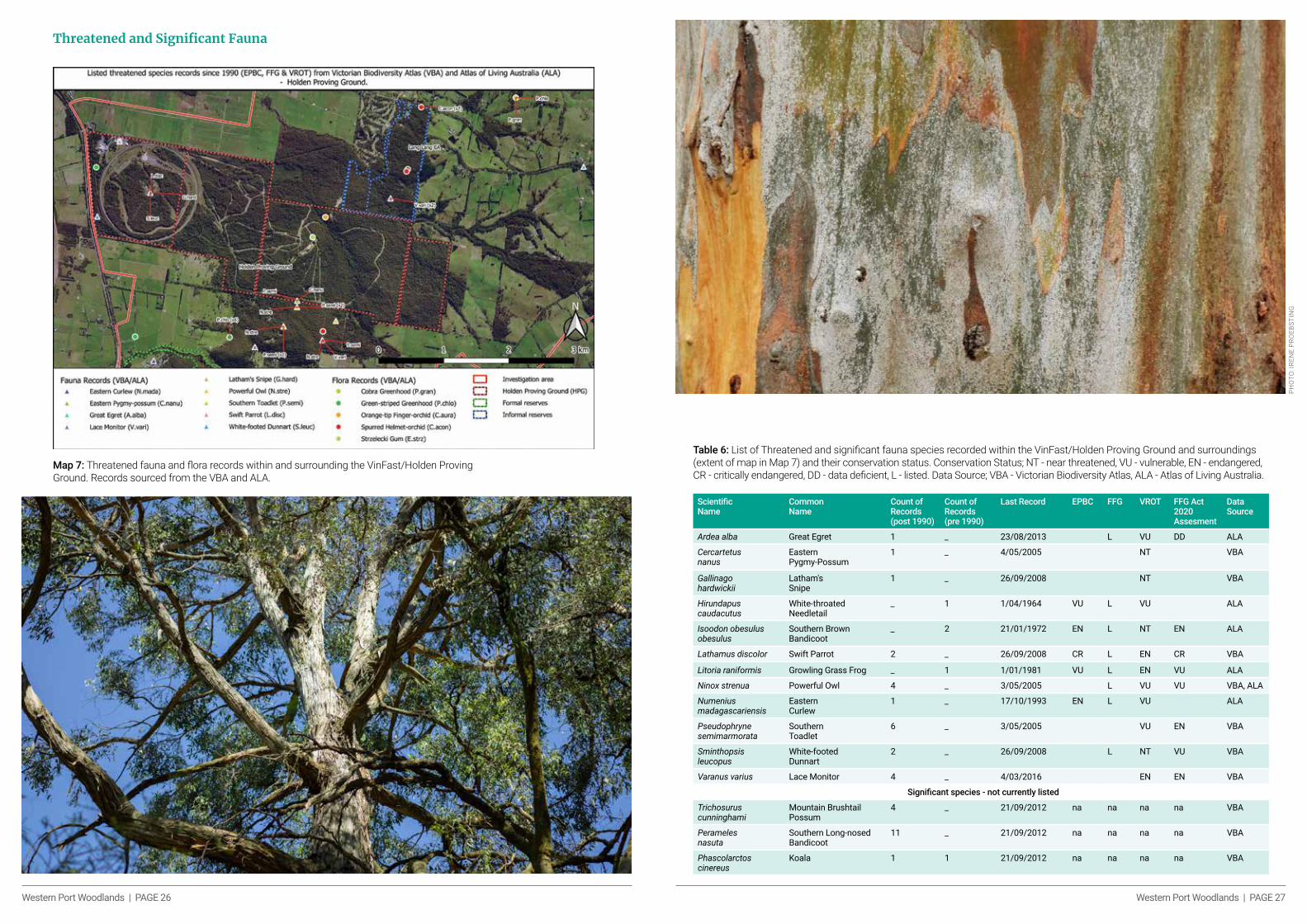
Threatened and Significant Fauna
Map 7: Threatened fauna and flora records within and surrounding the VinFast/Holden Proving Ground. Records sourced from the VBA and ALA.
Table 6: List of Threatened and significant fauna species recorded within the VinFast/Holden Proving Ground and surroundings (extent of map in Map 7) and their conservation status. Conservation Status; NT - near threatened, VU - vulnerable, EN - endangered, CR - critically endangered, DD - data deficient, L - listed. Data Source; VBA - Victorian Biodiversity Atlas, ALA - Atlas of Living Australia.
Scientific Name
Common Name
Count of Records (post 1990)
Count of Records (pre 1990)
Last Record EPBC FFG VROT FFG Act 2020 Assesment
Data Source
Ardea alba Great Egret 1 _ 23/08/2013 L VU DD ALA
Cercartetus nanus
Eastern Pygmy-Possum
1 _ 4/05/2005 NT VBA
Gallinago hardwickii
Latham's Snipe
1 _ 26/09/2008 NT VBA
Hirundapus caudacutus
White-throated Needletail
_ 1 1/04/1964 VU L VU ALA
Isoodon obesulus obesulus
Southern Brown Bandicoot
_ 2 21/01/1972 EN L NT EN ALA
Lathamus discolor Swift Parrot 2 _ 26/09/2008 CR L EN CR VBA
Litoria raniformis Growling Grass Frog _ 1 1/01/1981 VU L EN VU ALA
Ninox strenua Powerful Owl 4 _ 3/05/2005 L VU VU VBA, ALA
Numenius madagascariensis
Eastern Curlew
1 _ 17/10/1993 EN L VU ALA
Pseudophryne semimarmorata
Southern Toadlet
6 _ 3/05/2005 VU EN VBA
Sminthopsis leucopus
White-footed Dunnart
2 _ 26/09/2008 L NT VU VBA
Varanus varius Lace Monitor 4 _ 4/03/2016 EN EN VBA
Significant species - not currently listed
Trichosurus cunninghami
Mountain Brushtail Possum
4 _ 21/09/2012 na na na na VBA
Perameles nasuta
Southern Long-nosed Bandicoot
11 _ 21/09/2012 na na na na VBA
Phascolarctos cinereus
Koala 1 1 21/09/2012 na na na na VBA
PHO
TO: I
REN
E PR
OEB
STIN
G

Western Port Woodlands | PAGE 28 Western Port Woodlands | PAGE 29
period, and in a semi-nomadic manner embark on a search of the richest areas of eucalyptus forests and woodlands (Kennedy and Tzaros 2005). With little remnant vegetation remaining in the area, the VinFast/Holden Proving Ground provides this crucial foraging habitat for the Swift Parrots that visit the area.
Surveys within the grounds in 2012 indicated there to be a population of Long-nosed Bandicoots present (VBA 2020), which is a substantial distance from the previously known populations of the species. This presence of this species is also important for ecosystem health as their foraging habits are understood to have a positive impact on soil quality through the spreading of spores of native fungi and assisting in the decomposition of organic matter (Parks Victoria 2019).
The fauna species records within and surrounding the VinFast/Holden Proving Ground indicate that it contains appropriate and important habitat for many threatened species such as the Powerful Owl, Southern Toadlet and White-footed Dunnart, and the Critically Endangered Swift Parrot. Powerful Owls require the riparian zones for roosting and foraging, and also the high level of tree cover (Isaac 2012) present throughout most of the property (see Powerful Owl case study, page 36). White footed Dunnarts have been recorded in both Heathy Woodland and Wet Heathlands among other vegetation types across their range in Victoria (DSE 2012), indicating that appropriate habitat is available on the property. Swift Parrots migrate from Tasmania to the south-eastern mainland every autumn for the winter
PHO
TO: I
REN
E PR
OEB
STIN
G
Scientific Name
Common Name
Count of Records (post 1990)
Last Record EPBC FFG VROT FFG Act 2020 Assessment
Data Source
Caladenia aurantiaca Orange-tip Finger-orchid 1 6/10/1995 R EN ALA
Corybas aconitiflorus Spurred Helmet-orchid 5 19/06/2015 R VU ALA
Eucalyptus strzeleckii Strzelecki Gum 1 22/03/2001 VU L VU CR VBA
Pterostylis chlorogramma Green-striped Greenhood 7 29/07/1994 VU L VU EN ALA
Pterostylis grandiflora Cobra Greenhood 1 29/07/1994 R EN ALA
Threatened Flora
Table 7: List of Threatened flora species recorded within the VinFast/Holden Proving Ground and surroundings (extent of map in Map 7) and their conservation status. Conservation Status; VU - vulnerable, EN - endangered, CR - critically endangered, R - rare, L - listed. Data Source; VBA - Victorian Biodiversity Atlas, ALA - Atlas of Living Australia.
Within the rich flora of the VinFast/Holden Proving Ground site there are records of a Strzelecki Gum situated in the centre of the grounds, and of a number of threatened orchid species recorded within and surrounding the property. These detections indicate the likelihood of more of these species being present within the area. However further surveys would be required to verify this.
Connectivity
The vegetation that extends throughout the VinFast/Holden Proving Ground property and beyond provides important connectivity between the surrounding reserves and bushland. This allows for species dispersal across the habitat patches within the fragmented landscape and assists in maintaining genetic diversity. However, what may be an adequate level of vegetation connectivity for the movement of some species will not necessarily be appropriate for others (Bennett 1999). Therefore, to enhance the opportunity for species dispersal it is important to maintain current corridors of vegetation and expand on the existing vegetation and corridors.
The larger the habitat corridor the more species will be able to use it, and to adapt to changes such as fire, pest invasion and climate change.
Habitat fragmentation as a threatening process for fauna in Victoria is listed as a Threatening Process under the FFG Act.
Summary
A number of factors influence the value and significance of the VinFast/Holden Proving Ground site and the native vegetation that it contains. The entire property and much of its surrounds contain significant remnant vegetation, enabling important connectivity throughout the area that is critical for the persistence of many of the species inhabiting the area. The fence has enabled many species to thrive within the property without the impacts of invasive predators, and minimising human interference. The riparian zones and heathy woodlands that make up the majority of the grounds offer key habitat for many threatened and significant species and have the potential to support high levels of biodiversity.
In order to develop a complete understanding of the conservation values and biodiversity that the VinFast/Holden Proving Ground contains, and where the prospects lie for further conservation efforts of the species present, further comprehensive surveys need to be undertaken for the various taxa that inhabit the area.

Western Port Woodlands | PAGE 30 Western Port Woodlands | PAGE 31
Key Species - Case Studies As part of this report four species were selected that are found along the corridor of native vegetation from Nyora to Grantville. These species are found across both private and public land and require continuous native vegetation to allow them to move across the landscape. All the species selected are listed under state and or Commonwealth threatened species legislation.
Southern Brown Bandicoot (Eastern) (Isoodon obesulus obesulus)The Southern Brown Bandicoot is a medium-sized (about 30cm in length) terrestrial omnivorous marsupial. Described as compact and robust in form, they have a tapering snout, rounded ears and short tail. The eastern subspecies of the Southern Brown Bandicoot (Isoodon obesulus obesulus) is present within the investigation area. It has a disjunct distribution from Kangaroo Island and the Mount Lofty Ranges in South Australia through southern Victoria, to north of Sydney in New South Wales and excludes Tasmania (DSE 2010). However, recent findings (Cooper et al. 2019) support suggestions that the Mount Lofty Ranges and Kangaroo Island populations should be regarded as different taxa from I. o. obesulus (Avise & Bull 1990), meaning for the latter the new western limit would fall near Mt Gambier in south-eastern South Australia, significantly reducing the current subspecies range by >350km to the east.
There are five disjunct populations of Southern Brown Bandicoots (eastern) within Victoria. The south central metapopulation’s range includes the Western Port Woodlands (Coates et al. 2008) which makes up a high proportion of its existing habitat. This report’s investigation area partly covers this metapopulation’s range.
Habitat requirements
In Victoria, Southern Brown Bandicoots are known to inhabit heathlands, scrubland, open forest and woodland with well-drained soils, and “dry” heath communities (Menkhorst & Seebeck 1990). Several other factors have been put forward as important in determining distribution and abundance of Southern Brown Bandicoot, such as a seral (successional) stage of vegetation and post-fire successional stage (Braithwaite & Gullan 1978, Stoddart & Braithwaite 1979), though results appear to be mixed, and it is thought that vegetation structure (i.e density of ground layer) and soil may be a greater driver in abundance than floristic assemblage (Lobert 1985, Paul 2003). Additionally, abundant rainfall and its influence on invertebrate, plant and animal biomass has been shown to affect both distribution and abundance of Southern Brown Bandicoots (Opie et al. 1990, Driessen & Rose 2015). Recent studies also indicate Southern Brown Bandicoots can persist in a fragmented peri-urban landscape (Coates et al. 2008, Nicholls et al. 2018) and that linear habitat may be useful in maintaining connectivity in subpopulations (Coates et al. 2008, Maclagan et al. 2019, Maclagan, Coates & Ritchie, 2018).
Dense vegetation is typical of nest and shelter sites with coarse woody debris being an important component. Southern Brown bandicoots have also been documented to opportunistically use landscape features such as space under rocks and existing burrows, and in some cases creating burrows (Long 2009, DSE 2010). Additionally, the bandicoots use exotic vegetation cover. It is likely that the relationship between dense vegetation cover and increased abundance of Southern Brown Bandicoots is influenced by a reduction in predation risk (DSE 2010). K
ey S
pec
ies
- C
ase
Stu
die
s
Conservation Status and Threats
The Southern Brown Bandicoot (eastern) is listed as Endangered under Commonwealth law and in New South Wales (EPBC Act and TSC Act), Vulnerable in South Australia (NPW Act) and Near Threatened in Victoria (FFG Act), but has recently been reassessed in the FFG Act Conservation Status Assessment project and determined as Vulnerable (pending approval) in Victoria (DAWE 2007, DELWP 2020a).
Since colonisation the Southern Brown Bandicoot has undergone severe range contractions and population declines, with estimates that the species has experienced 50–90% declines from its former range (DSE 2010, Maxwell et al 1996). Significant land clearing and modification have been highlighted as having profound impact on habitat of the species and were probably a key driver in their historical decline (Paul 2003). In Victoria the species is likely to be undergoing continued decline, major current threats including habitat loss or modification, inappropriate fire regimes, extensive wildfires, introduced predators, and isolation of populations (DSE 2010). The interactive effects of habitat loss or modification, predation (particularly by the introduced Red Fox) and isolation of populations, is of major concern (Berghout 2000, DEPI 2013).
The Southern Brown Bandicoot populations in the region were assessed to have a high likelihood of extinction without active management. This was determined by a population viability analysis which did not consider impacts of further habitat loss (Lechner 2006).
Records within the investigation area
The earliest ALA and VBA records of Southern Brown Bandicoots from within the investigation area go back to 1972, the most recent records occurring in 2019. Records total 59, of which 51 occurred since 1990. Predominantly Southern Brown Bandicoot records occurred within and adjacent to the Adams Creek NCR, with the exception of two records near Wuchatsch Reserve and a single record adjacent to Grantville NCR. There have also been sightings of Southern Brown Bandicoots in the Grantville gravel reserve (as reported by Kutt and Yugovic 1996), anecdotal reports of ‘bandicoots’ at the VinFast/Holden Proving Ground site, and some evidence in the form of diggings at the Lang Lang Golf Course and Lang Lang EA (Ecology Australia 2009).
Though more recent surveys at the VinFast/Holden Proving Ground site failed to detect Southern Brown Bandicoots (DEPI 2013). Historically, diggings were attributed to bandicoot but hair-tube surveys did detect bandicoots (Nichols K. & M. Mackay 2003). It should also be noted that Long-nosed Bandicoots have since been recorded within the VinFast/Holden Proving Ground site (Bass Coast Landcare Network, 2013, Biosis 2013) and Lang Lang EA (Parks Victoria pers comm.) and ‘may’ account for the anecdotal reports of Southern Brown Bandicoots. There is no verified evidence of Southern Brown Bandicoot in these two areas despite the habitat being the preferred habitat for the species and considerable survey effort (Nicholls, DG per comms.).
PHO
TO: R
ICAR
DO
SIM
AO
Western Port Woodlands | PAGE 32 Western Port Woodlands | PAGE 33
Adams Creek NCR represents the largest known population of Southern Brown Bandicoots within the investigation area. The population is currently being managed by Parks Victoria, which is undertaking monitoring and fox control as part of its Southern Brown Bandicoot Protection Program (Parks Victoria 2017). There is significant suitable habitat adjoining Adams Creek NCR, both to the north – Wuchatsch Reserve (including surrounding private land) – and south – VinFast/Holden Proving Ground, Lang Lang EA, Lang Lang golf course and surrounding private land. Current and proposed mining tenements threaten these habitats and serve to further isolate the population, with likely conflict due to the species’ habitat requirement for well-drained soils (sandy soils) and the key extractive industry being sand mining (Menkhorst & Seebeck 1990).
Southern Brown Bandicoots have received a significant amount of conservation attention within the broader region. The ‘Sub-regional Species Strategy for the Southern Brown Bandicoot’ which began in 2017 and will continue until 2026, is directed at protecting Southern Brown Bandicoot populations centred around the former Koo Wee Rup swamp. Although the strategy did identify the investigation area as a possible for extension, no such action has been taken (DEPI 2014, DELWP 2016). The Southern Brown Bandicoot Recovery Program initiated in 2003 by the Western Port Biosphere would probably encompass populations of the investigation area, though there is little
to no publicly available information on the program or actions taken (Western Port Biosphere 2020). Similarly, the Southern Brown Bandicoot Protection Program by Parks Victoria lacks publicly available information (Parks Victoria 2017).
There are substantial survey efforts being undertaken by the Southern Brown Bandicoot Regional Recovery Group in the investigation area outlined in this report. This survey work will run until November 2021 (per comms. Nicholls,DG.).
Southern Brown Bandicoot, Adams Creek Nature Conservation Reserve
PHO
TO: S
OU
THER
N B
RO
WN
BAN
DIC
OO
T R
EGIO
NAL
REC
OVE
RY G
RO
UP
Recommendations
• Formalising Lang Lang EA to increase protected (current and potential) habitat for Southern Brown Bandicoots.
• Increasing fox control (integrated-pest management) to reduce pressure on population and expanding control area to increase available habitat area for Southern Brown Bandicoots. (Coates 2008 showed that reduced predation pressure via fox control enabled Southern Brown Bandicoots to use new sites with less cover).
• Further targeted surveys to establish the extent of the Southern Brown Bandicoot population, both surrounding the existing population and historical (Grantville NCR and surrounds).
Tea-tree Fingers (Hypocreopsis amplectens) is listed as Critically Endangered on the global International Union for the Conservation of Nature (IUCN 2019) and the only listed fungus under Victorian legislation (FFG Act) (DEPI 2014). An analysis of the Victorian Biodiversity Atlas reveals that of the 27 records, 77% occur within the West Gippsland investigation area (DELWP 2020b).
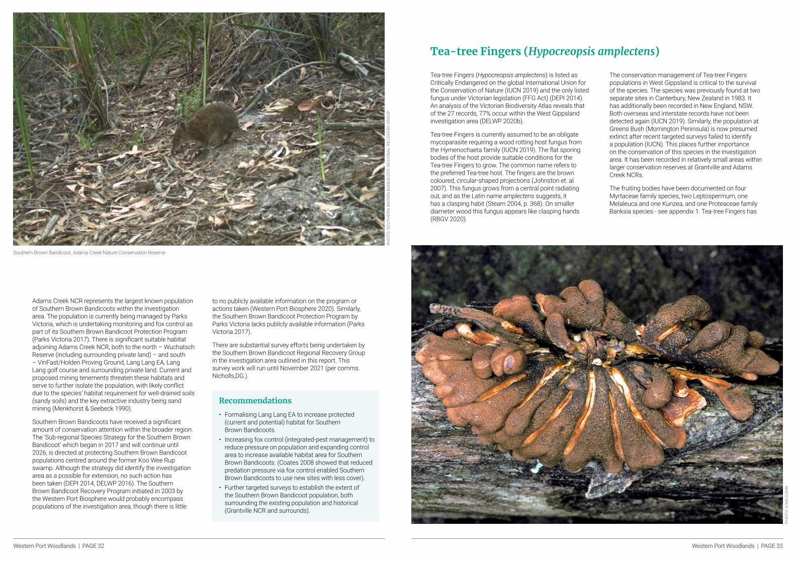
Tea-tree Fingers is currently assumed to be an obligate mycoparasite requiring a wood rotting host fungus from the Hymenochaeta family (IUCN 2019). The flat sporing bodies of the host provide suitable conditions for the Tea-tree Fingers to grow. The common name refers to the preferred Tea-tree host. The fingers are the brown coloured, circular-shaped projections (Johnston et. al 2007). This fungus grows from a central point radiating out, and as the Latin name amplectens suggests, it has a clasping habit (Stearn 2004, p. 368). On smaller diameter wood this fungus appears like clasping hands (RBGV 2020).
The conservation management of Tea-tree Fingers populations in West Gippsland is critical to the survival of the species. The species was previously found at two separate sites in Canterbury, New Zealand in 1983. It has additionally been recorded in New England, NSW. Both overseas and interstate records have not been detected again (IUCN 2019). Similarly, the population at Greens Bush (Mornington Peninsula) is now presumed extinct after recent targeted surveys failed to identify a population (IUCN). This places further importance on the conservation of this species in the investigation area. It has been recorded in relatively small areas within larger conservation reserves at Grantville and Adams Creek NCRs.
The fruiting bodies have been documented on four Myrtaceae family species, two Leptospermum, one Melaleuca and one Kunzea, and one Proteaceae family Banksia species - see appendix 1. Tea-tree Fingers has
Tea-tree Fingers (Hypocreopsis amplectens)
PHO
TO: I
LMA
DU
NN

Western Port Woodlands | PAGE 34 Western Port Woodlands | PAGE 35
been observed in Melaleuca squarosa thickets and Heathy Woodland vegetation (Johnston et. al 2007). Tea-Tree Fingers prefers 5–10cm diameter wood substrate developed over 30 years in the absence of fire. Field observations show it occupying dead standing and partly elevated fallen branches (ICUN 2019). The species has been recorded from the May–September period with most records between the June and July winter months (DELWP 2020b). Future management threats include climate change, increased fire intensity, and further clearing of potential habitat.
Table 8: List of vascular plant species that Tea-tree Fingers (Hypocreopsis amplectens) has been observed occupying.
Family Host vascular plants species Common name
Proteaceae Banksia marginata Silver Banksia
Myrtaceae Kunzea leptospermoides Yarra Burgan
Myrtaceae Leptospermum continentale Prickly Tea-tree
Myrtaceae Leptospermum mrysinioides Heath Tea-tree
Myrtaceae Melaleuca squarossa Scented Paperbark
PHO
TO: J
OH
N E
ICH
LER
Tea-tree Fingers, Adams Creek Nature Conservation Reserve.
Recommendations
• International Union for Conservation of Nature (2019) recommend an insurance population of Tea-tree Fingers be established, further targeted presence/absence surveys, improved monitoring of species and its response to fire and identification of host fungus to improve targeted search.
Green-striped Greenhood (Pterostylis chlorogramma)Green-striped Greenhood (Pterostylis chlorogramma) is endemic to Victoria with its main population within the West Gippsland investigation area. It is listed as Vulnerable under Commonwealth law (EPBC Act) and Vulnerable in Victoria (FFG Act) (RBVG, 2018). It occurs at Adams Creek NCR, The Gurdies NCR, the VinFast/Holden Proving Ground and a scattering of private property within the investigation area. It occupies mixed Box-Stringybark forest found on sandy or clay loam soils with associated species listed in Appendix 1. This species appears to be restricted to open areas including natural gaps in shrubby understorey or road and track verges. Future conservation of the species requires surveys and habitat mapping (Duncan et. al 2010).
The Green-striped Greenhood is a summer-dormant terrestrial orchid that emerges from a subterranean tuber. It produces up to seven green-striped flowers from July to early September. The labellum is commonly an emerald green colour, rarely brownish. It is distinguished from the similar Pterostylis smargdyna by paler, smaller flowers and less developed lateral lobes (RBVG 2018).
The species was likely to be more common in the past, with current populations lost to land clearing associated with residential and agricultural development (Duncan et. al 2010).
Table 9: Species associated with Green-striped Greenhood (Pterostylis chlorogramma).
Lifeform Species Common Name
Tree Eucalyptus obliqua Messmate-stringybark
Tree Eucalyptus cephalocarpa Silver-leafed Stringybark
Tree Eucalyptus cypellocarpa Mountain Grey-gum
Shrub Acacia mucronata Variable Sallow Wattle
Shrub Bursaria spinosa Sweet Bursaria
Shrub Dillwynia glaberrima Smooth Parrot-pea
Shrub Epacris impressa Common Heath
Shrub Hakea ulicina Furze Hakea
Shrub Leptospermum laevigatum Coast Tea-tree
Shrub Monotoca scoparia Prickly Broom Heath
Fern Pteridium esculentum Bracken
PHO
TO: G
EOFF
GLA
RE
Western Port Woodlands | PAGE 36 Western Port Woodlands | PAGE 37
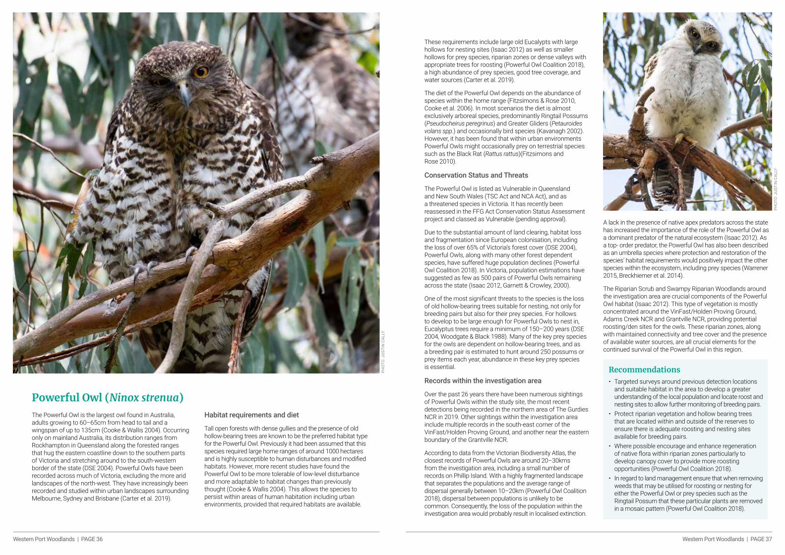
The Powerful Owl is the largest owl found in Australia, adults growing to 60–65cm from head to tail and a wingspan of up to 135cm (Cooke & Wallis 2004). Occurring only on mainland Australia, its distribution ranges from Rockhampton in Queensland along the forested ranges that hug the eastern coastline down to the southern parts of Victoria and stretching around to the south-western border of the state (DSE 2004). Powerful Owls have been recorded across much of Victoria, excluding the more arid landscapes of the north-west. They have increasingly been recorded and studied within urban landscapes surrounding Melbourne, Sydney and Brisbane (Carter et al. 2019).
Habitat requirements and diet
Tall open forests with dense gullies and the presence of old hollow-bearing trees are known to be the preferred habitat type for the Powerful Owl. Previously it had been assumed that this species required large home ranges of around 1000 hectares and is highly susceptible to human disturbances and modified habitats. However, more recent studies have found the Powerful Owl to be more tolerable of low-level disturbance and more adaptable to habitat changes than previously thought (Cooke & Wallis 2004). This allows the species to persist within areas of human habitation including urban environments, provided that required habitats are available.
PHO
TO: J
UST
IN C
ALLY
Powerful Owl (Ninox strenua)
These requirements include large old Eucalypts with large hollows for nesting sites (Isaac 2012) as well as smaller hollows for prey species, riparian zones or dense valleys with appropriate trees for roosting (Powerful Owl Coalition 2018), a high abundance of prey species, good tree coverage, and water sources (Carter et al. 2019).
The diet of the Powerful Owl depends on the abundance of species within the home range (Fitzsimons & Rose 2010, Cooke et al. 2006). In most scenarios the diet is almost exclusively arboreal species, predominantly Ringtail Possums (Pseudocheirus peregrinus) and Greater Gliders (Petauroides volans spp.) and occasionally bird species (Kavanagh 2002). However, it has been found that within urban environments Powerful Owls might occasionally prey on terrestrial species such as the Black Rat (Rattus rattus)(Fitzsimons and Rose 2010).
Conservation Status and Threats
The Powerful Owl is listed as Vulnerable in Queensland and New South Wales (TSC Act and NCA Act), and as a threatened species in Victoria. It has recently been reassessed in the FFG Act Conservation Status Assessment project and classed as Vulnerable (pending approval).
Due to the substantial amount of land clearing, habitat loss and fragmentation since European colonisation, including the loss of over 65% of Victoria’s forest cover (DSE 2004), Powerful Owls, along with many other forest dependent species, have suffered huge population declines (Powerful Owl Coalition 2018). In Victoria, population estimations have suggested as few as 500 pairs of Powerful Owls remaining across the state (Isaac 2012, Garnett & Crowley, 2000).
One of the most significant threats to the species is the loss of old hollow-bearing trees suitable for nesting, not only for breeding pairs but also for their prey species. For hollows to develop to be large enough for Powerful Owls to nest in, Eucalyptus trees require a minimum of 150–200 years (DSE 2004, Woodgate & Black 1988). Many of the key prey species for the owls are dependent on hollow-bearing trees, and as a breeding pair is estimated to hunt around 250 possums or prey items each year, abundance in these key prey species is essential.
Records within the investigation area
Over the past 26 years there have been numerous sightings of Powerful Owls within the study site, the most recent detections being recorded in the northern area of The Gurdies NCR in 2019. Other sightings within the investigation area include multiple records in the south-east corner of the VinFast/Holden Proving Ground, and another near the eastern boundary of the Grantville NCR.
According to data from the Victorian Biodiversity Atlas, the closest records of Powerful Owls are around 20–30kms from the investigation area, including a small number of records on Phillip Island. With a highly fragmented landscape that separates the populations and the average range of dispersal generally between 10–20km (Powerful Owl Coalition 2018), dispersal between populations is unlikely to be common. Consequently, the loss of the population within the investigation area would probably result in localised extinction.
A lack in the presence of native apex predators across the state has increased the importance of the role of the Powerful Owl as a dominant predator of the natural ecosystem (Isaac 2012). As a top- order predator, the Powerful Owl has also been described as an umbrella species where protection and restoration of the species’ habitat requirements would positively impact the other species within the ecosystem, including prey species (Warrener 2015, Breckhiemer et al. 2014).
The Riparian Scrub and Swampy Riparian Woodlands around the investigation area are crucial components of the Powerful Owl habitat (Isaac 2012). This type of vegetation is mostly concentrated around the VinFast/Holden Proving Ground, Adams Creek NCR and Grantville NCR, providing potential roosting/den sites for the owls. These riparian zones, along with maintained connectivity and tree cover and the presence of available water sources, are all crucial elements for the continued survival of the Powerful Owl in this region.
PHO
TO: J
UST
IN C
ALLY
Recommendations
• Targeted surveys around previous detection locations and suitable habitat in the area to develop a greater understanding of the local population and locate roost and nesting sites to allow further monitoring of breeding pairs.
• Protect riparian vegetation and hollow bearing trees that are located within and outside of the reserves to ensure there is adequate roosting and nesting sites available for breeding pairs.
• Where possible encourage and enhance regeneration of native flora within riparian zones particularly to develop canopy cover to provide more roosting opportunities (Powerful Owl Coalition 2018).
• In regard to land management ensure that when removing weeds that may be utilised for roosting or nesting for either the Powerful Owl or prey species such as the Ringtail Possum that these particular plants are removed in a mosaic pattern (Powerful Owl Coalition 2018).

Western Port Woodlands | PAGE 38 Western Port Woodlands | PAGE 39
Threats to BiodiversityExtractive Industry – Sand Mining
Mining is recognised to have significant impacts on social, environmental and cultural values. Sand mining, a key extractive resource within the investigation area, is no different. The key driving force behind mining is its economic value. But the benefits of mining are not evenly distributed, and often come as a cost to environmental and social values (Sincovich et al. 2018). Environmental impacts of sand mining, though fewer than those of other resources (coal, gold, etc.) are still numerous and significant. They include land clearing, habitat destruction, wildlife mortality or displacement, increased air pollutants, water pollution (cascading effects on aquatic fauna and flora), soil pollution (soil infertility and accumulation of toxins), alteration to hydrology, soil erosion and greenhouse gas emission (Gavriletea 2017). The impacts of mining are long-lasting and rarely remediated, with as few as 4% of mines in Australia being classed as ‘rehabilitated’, 68% being classed as ‘neglected’ and ~82% (80,000 sites) requiring rehabilitation (Werner 2020). Furthermore, there are unclear standards for the level of rehabilitation required (The Australian Institute, 2017), along with ‘systemic regulatory failures in rehabilitation cost estimates, bond management, auditing of rehabilitation plans and review of on-site practices’ in Victoria (Victorian Auditor-General’s Office, 2020).
The demand for extractive resources is expected to double in Victoria between 2015 and 2050, with South Gippsland and Cardinia LGAs being highlighted as critical resource locations, while Bass Coast LGA was predicted to decline due to exhaustion of the resources (PwC 2016). The Strategic Extractive Resource Areas (SERA) – Pilot Project identified South Gippsland LGA as a ‘pilot SERA-investigation area’ and was chosen due to long term supplies of quality sand, location in relation to demand areas, the sand resources extending into adjoining LGAs and potential for expansion (State of Victoria 2020). The in-trial SERA concept looks to ensure extractive industry resources by imposing State Resource Overlays and Special Use Zones where these resources are found, and other criteria are met. The impact of this proposed SERA on conservation values will be significant; it will encompass the already stressed Adams Creek NCR, further fragment the already highly fragmented reserve network as well as paving the way for future SERA implementation in adjoining LGAs (Victorian Government. 2019).
The investigation area is already subject to high-level resource extraction proportionate to it size, with ~13% of the area being under Work Authorities (WA) (~10% current and ~3% application) and ~40% of the area being highlighted as an ‘Extractive Industry Interest Area’ (Olshina & Burn 2003), a forerunner to SERA designation. Furthermore, though each LGA has only a small proportion of its total area within the investigation area (8.13% Bass Coast, 1.32% Cardinia and 1.01% South Gippsland), the investigation area represents a significant proportion of each LGA’s current and application WAs (81.82%, 11.59% and 59.59% respectively).
Currently there are 27 WAs within the investigation area, 19 current and 7 under application. All WAs listed as current (bar WA512 & WA40) have works being undertaken, most of these operating as large-scale quarries.
Though WA512 and WA40 have ‘current’ status, they appear to have not yet commenced works or are (for now) small sites. These WAs encompass areas of high conservation value and significance for the greater reserve network, due to their location and high level of vegetation cover. WA40 abuts the VinFast/Holden Proving Ground to the south and Lang Lang EA to the west; it serves to increase the total vegetated area within the network and is the only connection between the reserves and a significant amount of vegetation
Th
reat
s to
Bio
div
ersi
tyPH
OTO
: WO
OD
RO
W W
ILSO
N P
HO
TOG
RAP
HY
to the east. Similarly, WA512, which consists of two parcels located north-west of Grantville NCR, is a key corridor for connecting Grantville NCR with vegetation and the reserves to the north. If the adjoining WA513 under application is granted, this fragmentation would be even more significant (see Map 8).There are already several significant barriers between vegetation and reserves due to quarries. These include (see Map 8):
• Wuchatsch Reserve to Adams Creek NCR blocked by WA333, WA423 and WA2.
• Adams Creek NCR to Lang Lang EA blocked by WA1004, WA1102, WA157.
• The Gurdies NCR to Grantville BR and Colbert CK BR blocked by WA1488.
• Grantville BR and Colbert CK BR to Corinella BR and Grantville NCR blocked by WA470.
Additionally, there are also WA applications which would impose further fragmentation between vegetation and reserves. These include (see Map 8):
• Grantville NCR to Grantville BR, Colbert CK BR and Corinella BR to be blocked by application WA513 (as previously mentioned).
• Holden Proving Ground to Hurdy Gurdy Creek NCR to be blocked by application WA1453 and WA1452.
It is clear that current mining imposes significant stress on the reserve network, and that future works, both imminent and under application, will further compound this issue. The current works, impetus for future works and clear gaps in environmental consideration make mining one of the single greatest threats to this network of reserves and all the biodiversity contained within it.
PHO
TO: W
OO
DR
OW
WIL
SON
PH
OTO
GR
APH
Y

Western Port Woodlands | PAGE 40 Western Port Woodlands | PAGE 41
Map 8: Current extractive industry tenements and Extractive Industry Interest Areas (EIIA) within and surrounding the investigation area.
Land Clearing
Extensive land clearing has already caused major impacts on the native species within the Gippsland Plain Bioregion and the investigation area. The Gippsland Plain Bioregion is in the top five most cleared bioregions on Victoria (VEAC 2011).
More than half of the state’s native vegetation has been cleared since European settlement (DELWP 2017).
Landscapes cleared for agricultural purposes are generally those with a high level of productivity including rich and fertile soils within valleys or flat terrain and riparian zones. These landscapes are commonly of high value for native flora and fauna in terms of species richness and biodiversity (VEAC 2011). Clearing these landscapes for agriculture and other land uses has led to the loss and displacement of many native species that would have once occupied these highly productive landscapes.
Although the rate of land clearing has slowed since the introduction of Victoria’s native vegetation regulations in 1989, the quality and extent of native vegetation continues to shrink by about 4000 habitat hectares each year. This trajectory is largely the result of activities and entitled uses that are outside the regulatory framework (resulting in loss of extent of native vegetation), together with insufficient management of threats (resulting in loss of quality). (DELWP 2017, Commissioner for Environmental Sustainability Victoria 2018). In terms of extent levels, clearing could be between 5,000 and 7,000 hectares per annum. This does not include the approximately 3000 hectares per annum removed as part of native forest logging operations.
The threatened species populations that occupy the investigation area are considerably isolated populations
that have been impacted greatly by habitat loss, now persisting within fragmented remnant vegetation. Land clearing is known to have caused population losses for Green-striped Greenhoods across their initial range (Duncan 2010). Habitat loss or modification through land clearing is recognised as a key threatening process for the Southern Brown Bandicoot (Brown and Main 2010), Tea-tree Fingers (second to fire)(ICUN 2019), and more specifically the loss of hollow- bearing trees has been recognised as a key threatening process for the Powerful Owl (DSE 2004).
Climate Change
Over the past two decades Victoria has endured some record-breaking temperature highs, with predictions that this is a trend likely to continue at an even faster rate (VEAC 2011). These changes in conditions have already caused, and are likely to continue to cause, an increase in fire frequency and intensity, threatening the highly vulnerable ecosystems throughout Victoria.
A continued increase in anthropogenic disturbances such as land clearing and pollution, combined with climate change and the associated extreme weather events causing floods, wildfires and drought, are likely to cause major impacts on natural ecosystems composition, structure and function, including the risk of complete collapse for the most vulnerable ecosystems (IPCC 2007).
The responses of native vegetation to the changes in climate conditions are likely to have a cascading effect within natural ecosystems. The increase in concentration of CO2 in the atmosphere enables plants to increase the rate of photosynthesis, resulting in the
PHO
TO: W
OO
DR
OW
WIL
SON
PH
OTO
GR
APH
Y
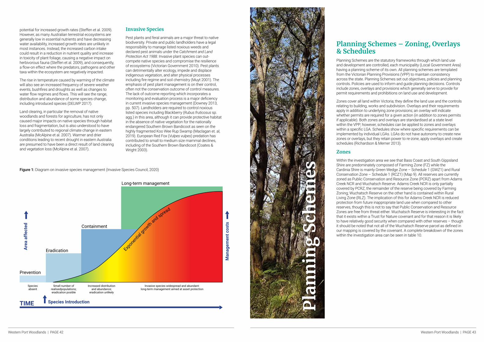
Western Port Woodlands | PAGE 42 Western Port Woodlands | PAGE 43
potential for increased growth rates (Steffen et al. 2009). However, as many Australian terrestrial ecosystems are generally low in essential nutrients and have decreasing water availability, increased growth rates are unlikely in most instances. Instead, the increased carbon intake could result in a reduction in nutrient quality and increase in toxicity of plant foliage, causing a negative impact on herbivorous fauna (Steffen et al. 2009), and consequently, a flow-on effect where the predators, pathogens and other taxa within the ecosystem are negatively impacted.
The rise in temperature caused by warming of the climate will also see an increased frequency of severe weather events, bushfires and droughts as well as changes to water flow regimes and flows. This will see the range, distribution and abundance of some species change, including introduced species (DELWP 2017).
Land clearing, in particular the removal of native woodlands and forests for agriculture, has not only caused major impacts on native species through habitat loss and fragmentation, but is also understood to have largely contributed to regional climate change in eastern Australia (McAlpine et al. 2007). Warmer and drier conditions leading to recent drought in eastern Australia are presumed to have been a direct result of land clearing and vegetation loss (McAlpine et al. 2007).
Invasive Species
Pest plants and feral animals are a major threat to native biodiversity. Private and public landholders have a legal responsibility to manage listed noxious weeds and declared pest animals under the Catchment and Land Protection Act 1988. Invasive plant species can out-compete native species and compromise the resilience of ecosystems (Victorian Government 2010). Pest plants can detrimentally alter ecology, impede and displace indigenous vegetation, and alter physical processes including fire regime and soil chemistry (Muyt 2001). The emphasis of pest plant management is on their control, often not the conservation outcome of control measures. The lack of outcome reporting which incorporates a monitoring and evaluation process is a major deficiency in current invasive species management (Downey 2013, pp. 507). Landholders are required to control noxious listed species including Blackberry (Rubus fruticosus sp. agg.) in this area, although it can provide protective habitat in the absence of native vegetation for the nationally endangered Southern Brown Bandicoot as seen on the highly fragmented Koo Wee Rup Swamp (Maclagan et. al, 2019). European Red Fox (Vulpes vulpes) predation has contributed to small to medium size mammal declines, including of the Southern Brown Bandicoot (Coates & Wright 2003).
Figure 1: Diagram on invasive species management (Invasive Species Council, 2020)
Long-term management
Containment
Eradication
Prevention
Speciesabsent
Small number of realisedpopulations; eradication posible
Increased distribution and abundance;
eradication unlikely
Invasive species widespread and abundant: long-term management aimed at asset protection
Species IntroductionTIME
Are
a a
ffe
cte
d
Ma
na
ge
me
nt
co
sts
Exponen
tial g
row
th a
nd spread
Planning Schemes – Zoning, Overlays & SchedulesPlanning Schemes are the statutory frameworks through which land use and development are controlled, each municipality (Local Government Area) having a planning scheme of its own. All planning schemes are templated from the Victorian Planning Provisions (VPP) to maintain consistency across the state. Planning Schemes set out objectives, policies and planning controls. Policies are used to inform and guide planning decisions. Controls include zones, overlays and provisions which generally serve to provide for permit requirements and prohibitions on land use and development.
Zones cover all land within Victoria; they define the land use and the controls relating to building, works and subdivision. Overlays and their requirements apply in addition to underlying zone provisions; an overlay will indicate whether permits are required for a given action (in addition to zones permits if applicable). Both zones and overlays are standardised at a state level within the VPP; however, schedules can be applied to zones and overlays within a specific LGA. Schedules show where specific requirements can be implemented by individual LGAs. LGAs do not have autonomy to create new zones or overlays, but they retain power to re-zone, apply overlays and create schedules (Richardson & Merner 2013).
Zones
Within the investigation area we see that Bass Coast and South Gippsland Shire are predominately composed of Farming Zone (FZ) while the Cardinia Shire is mainly Green Wedge Zone – Schedule 1 (GWZ1) and Rural Conservation Zone – Schedule 1 (RCZ1) (Map 9). All reserves are currently zoned as Public Conservation and Resource Zone (PCRZ) apart from Adams Creek NCR and Wuchatsch Reserve. Adams Creek NCR is only partially covered by PCRZ, the remainder of the reserve being covered by Farming Zoning; Wuchatsch Reserve on the other hand is contained within Rural Living Zone (RLZ). The implication of this for Adams Creek NCR is reduced protection from future inappropriate land use when compared to other reserves, though this is not to say that Public Conservation and Resource Zones are free from threat either. Wuchatsch Reserve is interesting in the fact that it exists within a Trust for Nature covenant and for that reason it is likely to have relatively good security when compared with other reserves – though it should be noted that not all of the Wuchatsch Reserve parcel as defined in our mapping is covered by the covenant. A complete breakdown of the zones within the investigation area can be seen in table 10.
Pla
nn
ing
Sch
emes
Pla
nn
ing
Sch
emes
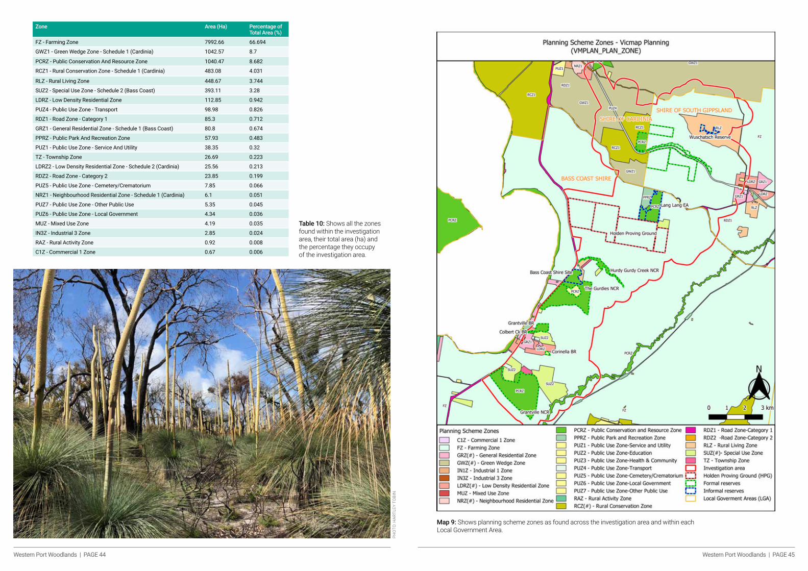
Western Port Woodlands | PAGE 44 Western Port Woodlands | PAGE 45
Table 10: Shows all the zones found within the investigation area, their total area (ha) and the percentage they occupy of the investigation area.
Zone Area (Ha) Percentage of Total Area (%)
FZ - Farming Zone 7992.66 66.694
GWZ1 - Green Wedge Zone - Schedule 1 (Cardinia) 1042.57 8.7
PCRZ - Public Conservation And Resource Zone 1040.47 8.682
RCZ1 - Rural Conservation Zone - Schedule 1 (Cardinia) 483.08 4.031
RLZ - Rural Living Zone 448.67 3.744
SUZ2 - Special Use Zone - Schedule 2 (Bass Coast) 393.11 3.28
LDRZ - Low Density Residential Zone 112.85 0.942
PUZ4 - Public Use Zone - Transport 98.98 0.826
RDZ1 - Road Zone - Category 1 85.3 0.712
GRZ1 - General Residential Zone - Schedule 1 (Bass Coast) 80.8 0.674
PPRZ - Public Park And Recreation Zone 57.93 0.483
PUZ1 - Public Use Zone - Service And Utility 38.35 0.32
TZ - Township Zone 26.69 0.223
LDRZ2 - Low Density Residential Zone - Schedule 2 (Cardinia) 25.56 0.213
RDZ2 - Road Zone - Category 2 23.85 0.199
PUZ5 - Public Use Zone - Cemetery/Crematorium 7.85 0.066
NRZ1 - Neighbourhood Residential Zone - Schedule 1 (Cardinia) 6.1 0.051
PUZ7 - Public Use Zone - Other Public Use 5.35 0.045
PUZ6 - Public Use Zone - Local Government 4.34 0.036
MUZ - Mixed Use Zone 4.19 0.035
IN3Z - Industrial 3 Zone 2.85 0.024
RAZ - Rural Activity Zone 0.92 0.008
C1Z - Commercial 1 Zone 0.67 0.006
PHO
TO: H
ARTL
EY T
OBI
N
Map 9: Shows planning scheme zones as found across the investigation area and within each Local Government Area.
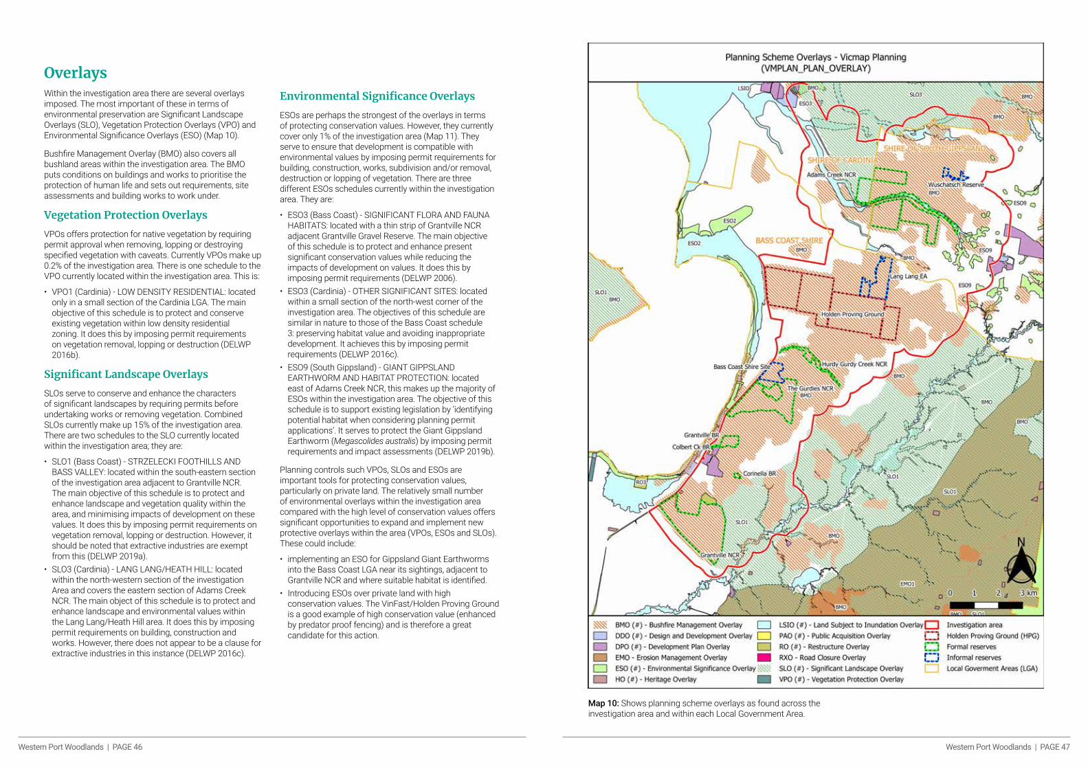
Western Port Woodlands | PAGE 46 Western Port Woodlands | PAGE 47
Overlays Within the investigation area there are several overlays imposed. The most important of these in terms of environmental preservation are Significant Landscape Overlays (SLO), Vegetation Protection Overlays (VPO) and Environmental Significance Overlays (ESO) (Map 10).
Bushfire Management Overlay (BMO) also covers all bushland areas within the investigation area. The BMO puts conditions on buildings and works to prioritise the protection of human life and sets out requirements, site assessments and building works to work under.
Vegetation Protection Overlays
VPOs offers protection for native vegetation by requiring permit approval when removing, lopping or destroying specified vegetation with caveats. Currently VPOs make up 0.2% of the investigation area. There is one schedule to the VPO currently located within the investigation area. This is:
• VPO1 (Cardinia) - LOW DENSITY RESIDENTIAL: located only in a small section of the Cardinia LGA. The main objective of this schedule is to protect and conserve existing vegetation within low density residential zoning. It does this by imposing permit requirements on vegetation removal, lopping or destruction (DELWP 2016b).
Significant Landscape Overlays
SLOs serve to conserve and enhance the characters of significant landscapes by requiring permits before undertaking works or removing vegetation. Combined SLOs currently make up 15% of the investigation area. There are two schedules to the SLO currently located within the investigation area; they are:
• SLO1 (Bass Coast) - STRZELECKI FOOTHILLS AND BASS VALLEY: located within the south-eastern section of the investigation area adjacent to Grantville NCR. The main objective of this schedule is to protect and enhance landscape and vegetation quality within the area, and minimising impacts of development on these values. It does this by imposing permit requirements on vegetation removal, lopping or destruction. However, it should be noted that extractive industries are exempt from this (DELWP 2019a).
• SLO3 (Cardinia) - LANG LANG/HEATH HILL: located within the north-western section of the investigation Area and covers the eastern section of Adams Creek NCR. The main object of this schedule is to protect and enhance landscape and environmental values within the Lang Lang/Heath Hill area. It does this by imposing permit requirements on building, construction and works. However, there does not appear to be a clause for extractive industries in this instance (DELWP 2016c).
Environmental Significance Overlays
ESOs are perhaps the strongest of the overlays in terms of protecting conservation values. However, they currently cover only 1% of the investigation area (Map 11). They serve to ensure that development is compatible with environmental values by imposing permit requirements for building, construction, works, subdivision and/or removal, destruction or lopping of vegetation. There are three different ESOs schedules currently within the investigation area. They are:
• ESO3 (Bass Coast) - SIGNIFICANT FLORA AND FAUNA HABITATS: located with a thin strip of Grantville NCR adjacent Grantville Gravel Reserve. The main objective of this schedule is to protect and enhance present significant conservation values while reducing the impacts of development on values. It does this by imposing permit requirements (DELWP 2006).
• ESO3 (Cardinia) - OTHER SIGNIFICANT SITES: located within a small section of the north-west corner of the investigation area. The objectives of this schedule are similar in nature to those of the Bass Coast schedule 3: preserving habitat value and avoiding inappropriate development. It achieves this by imposing permit requirements (DELWP 2016c).
• ESO9 (South Gippsland) - GIANT GIPPSLAND EARTHWORM AND HABITAT PROTECTION: located east of Adams Creek NCR, this makes up the majority of ESOs within the investigation area. The objective of this schedule is to support existing legislation by ‘identifying potential habitat when considering planning permit applications’. It serves to protect the Giant Gippsland Earthworm (Megascolides australis) by imposing permit requirements and impact assessments (DELWP 2019b).
Planning controls such VPOs, SLOs and ESOs are important tools for protecting conservation values, particularly on private land. The relatively small number of environmental overlays within the investigation area compared with the high level of conservation values offers significant opportunities to expand and implement new protective overlays within the area (VPOs, ESOs and SLOs). These could include:
• implementing an ESO for Gippsland Giant Earthworms into the Bass Coast LGA near its sightings, adjacent to Grantville NCR and where suitable habitat is identified.
• Introducing ESOs over private land with high conservation values. The VinFast/Holden Proving Ground is a good example of high conservation value (enhanced by predator proof fencing) and is therefore a great candidate for this action.
Map 10: Shows planning scheme overlays as found across the investigation area and within each Local Government Area.

Western Port Woodlands | PAGE 48 Western Port Woodlands | PAGE 49
Map 11: Environmental Significance Overlays (ESOs) found within and surrounding the investigation area.
Trust for NatureTrust for Nature (TFN) is a conservation organisation that operates with the purpose of protecting native flora and fauna on private land. This is achieved through conservation covenants, purchase and donation of land and working with private landowners and the state government. Using these methods of protecting land, Trust for Nature has permanently protected over 90,000 hectares of native vegetation in Victoria (TFN 2013).
Statewide Conservation Plan
In 2013 Trust for Nature developed a statewide Conservation Plan for Private Land in Victoria to give a statewide perspective of conservation values on private land for terrestrial and aquatic ecosystems and threatened species. Some of the relevant findings are as follows:
• Almost half of the bioregions in Victoria do not meet National Reserve System targets for ecosystem protection.
• Over 80% of EVCs found on private land within the Gippsland Plain Bioregion are under-represented in protected areas.
• 30 of the 124 EVCs found within the Gippsland Plains are found to be under-represented across the bioregion.
• The Gippsland Plains area has been recognised as a priority for increased ecosystem protection, with a particular focus on West Gippsland and the Port Phillip and Western Port regions.
• Nearly half of the total riparian vegetation on private land in Victoria has been cleared and only 1% is currently protected by TFN.
• In 2013 TFN found that the Gippsland Plains, particularly near the coast and developing areas, have been recognised as areas considered to be at greatest risk of habitat loss in the following decade. This includes within and surrounding the investigation area of this report.
Investigation Area Specifics
There are five land parcels within the investigation area that have Trust for Nature covenants, and one that is partially included within the boundary. These land parcels a total area of 67.73 hectares, which is less than 1% of the total investigation area. The EVCs included within the TFN covenanted land are predominantly Heathy Woodlands and Lowland Forests, with smaller portions of Riparian Scrub, Damp Heathy Woodland, Swampy Riparian Woodland and Herb-rich Foothill Forests.
There are ten species recorded within the investigation area, either recently or historically, that have been listed by TFN as ‘priority threatened fauna and flora species for conservation on private land’. These are Giant Gippsland Earthworm, Grey Goshawk, Growling Grass Frog, Lace Monitor, Latham’s Snipe, Powerful Owl, Rayed Blue, Southern Brown Bandicoot, Swift Parrot and Strzelecki Gum.
Tru
st f
or
Nat
ure
PHO
TO: W
OO
DR
OW
WIL
SON
PH
OTO
GR
APH
Y
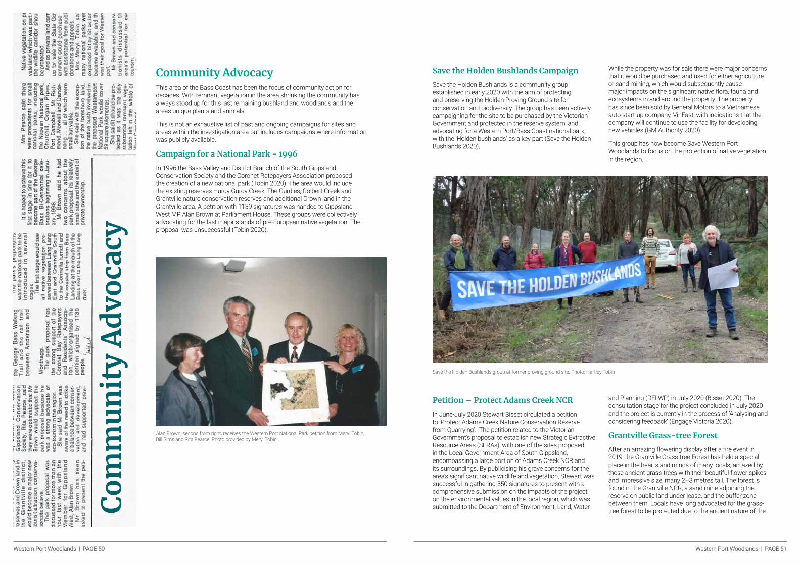
Western Port Woodlands | PAGE 50 Western Port Woodlands | PAGE 51
Community AdvocacyThis area of the Bass Coast has been the focus of community action for decades. With remnant vegetation in the area shrinking the community has always stood up for this last remaining bushland and woodlands and the areas unique plants and animals.
This is not an exhaustive list of past and ongoing campaigns for sites and areas within the investigation area but includes campaigns where information was publicly available.
Campaign for a National Park - 1996
In 1996 the Bass Valley and District Branch of the South Gippsland Conservation Society and the Coronet Ratepayers Association proposed the creation of a new national park (Tobin 2020). The area would include the existing reserves Hurdy Gurdy Creek, The Gurdies, Colbert Creek and Grantville nature conservation reserves and additional Crown land in the Grantville area. A petition with 1139 signatures was handed to Gippsland West MP Alan Brown at Parliament House. These groups were collectively advocating for the last major stands of pre-European native vegetation. The proposal was unsuccessful (Tobin 2020).
Co
mm
un
ity
Ad
voca
cy
Alan Brown, second from right, receives the Western Port National Park petition from Meryl Tobin, Bill Sims and Rita Pearce. Photo provided by Meryl Tobin
Save the Holden Bushlands Campaign
Save the Holden Bushlands is a community group established in early 2020 with the aim of protecting and preserving the Holden Proving Ground site for conservation and biodiversity. The group has been actively campaigning for the site to be purchased by the Victorian Government and protected in the reserve system, and advocating for a Western Port/Bass Coast national park, with the 'Holden bushlands' as a key part (Save the Holden Bushlands 2020).
Save the Holden Bushlands group at former proving ground site. Photo: Hartley Tobin
While the property was for sale there were major concerns that it would be purchased and used for either agriculture or sand mining, which would subsequently cause major impacts on the significant native flora, fauna and ecosystems in and around the property. The property has since been sold by General Motors to a Vietnamese auto start-up company, VinFast, with indications that the company will continue to use the facility for developing new vehicles (GM Authority 2020).
This group has now become Save Western Port Woodlands to focus on the protection of native vegetation in the region.
Petition – Protect Adams Creek NCR
In June-July 2020 Stewart Bisset circulated a petition to ‘Protect Adams Creek Nature Conservation Reserve from Quarrying’. The petition related to the Victorian Government’s proposal to establish new Strategic Extractive Resource Areas (SERAs), with one of the sites proposed in the Local Government Area of South Gippsland, encompassing a large portion of Adams Creek NCR and its surroundings. By publicising his grave concerns for the area’s significant native wildlife and vegetation, Stewart was successful in gathering 550 signatures to present with a comprehensive submission on the impacts of the project on the environmental values in the local region, which was submitted to the Department of Environment, Land, Water
and Planning (DELWP) in July 2020 (Bisset 2020). The consultation stage for the project concluded in July 2020 and the project is currently in the process of ‘Analysing and considering feedback’ (Engage Victoria 2020).
Grantville Grass-tree Forest
After an amazing flowering display after a fire event in 2019, the Grantville Grass-tree Forest has held a special place in the hearts and minds of many locals, amazed by these ancient grass-trees with their beautiful flower spikes and impressive size, many 2–3 metres tall. The forest is found in the Grantville NCR, a sand mine adjoining the reserve on public land under lease, and the buffer zone between them. Locals have long advocated for the grass-tree forest to be protected due to the ancient nature of the

Western Port Woodlands | PAGE 52 Western Port Woodlands | PAGE 53
grass-trees, the quality of the native vegetation and the area’s importance as a corridor for native wildlife. [Note: Locals have long advocated for the biolink, but didn’t know of the existence of the grass-tree forest until the trees flowered en masse in spring 2019. It was arguably, and possibly still is, the biggest and best grass- tree forest in Victoria, if not Australia.]
In mid-November 2020, local conservationists found more than 220 grass-trees dug up and bagged, presumably ready for translocation due to the expansion
of sand mining activities. Many of the grass-trees were in poor condition or close to death at the time of discovery.
Authorities have now investigated the clearing of the grass-tree forest. Bass Coast Shire CEO Ali Wastie said that shortly after the November council meeting, a site inspection was conducted: “The inspection concluded the quarry operations were being managed in a manner consistent with their work plans.” (Phillip Island & San Remo Advertiser, 24.2.2021.)
Dug up grass-trees, many in poor condition, at Grantville site, November 2020.
PHO
TO: C
ATH
ERIN
E W
ATSO
N
ConclusionIt is evident that the remnant vegetation that occurs throughout the string of reserves, VinFast/Holden Proving Ground and surrounding land within the investigation area holds undoubted significance for the local region, biodiversity and native flora and fauna and of the area. The extent of land clearing across the Gippsland Plain Bioregion has already caused major impacts to biodiversity through habitat loss and fragmentation, and if continued will be very likely to experience further species declines and localised extinctions.
The populations of many threatened species that inhabit the area have declined across their range, with land clearing and habitat loss commonly listed as both a cause of decline and a future threat. The heavily fragmented landscape and high levels of land clearing surrounding the area restrict the opportunities for dispersal for many of these species, particularly the small terrestrial or sub-terrestrial species such as the Southern Brown Bandicoot, Swamp Antechinus and Giant Gippsland Earthworm. This indicates the significance of the remnant vegetation that provides habitat for these isolated populations, as well as the importance of the connectivity throughout the area.
Multiple threatened species of flora and fungi have significant stronghold populations within the investigation area, where for some species there are few other extant populations. This is the case for Tea-tree Fingers, which has three quarters of its known Australian population within the investigation area, and for the Green-striped Greenhood, with its largest known population within The Gurdies NCR. The survival of these populations is crucial for the future persistence of both species. Increased pressure on remaining remnant vegetation will push these species further towards extinction. Protecting these areas will be of the utmost importance if we are to protect this array of species.
The VinFast/Holden Proving Ground contains the largest block of remnant vegetation within the investigation area. It provides crucial habitat for many species including the Powerful Owl, Southern Toadlet, White-footed Dunnart and Swift Parrot, and includes some of the largest areas of vital riparian vegetation.
The property also serves as an important link of vegetation between Adams Creek NCR, Lang Lang EA and Hurdy Gurdy Creek NCR, which protect many threatened species such as the Southern Brown Bandicoot and Lace Monitor. These deserve better protection – ideally they should be purchased as parts of the state-owned conservation estate, protected under a Trust For Nature covenant, or, at a minimum, given better protection with planning controls such as ESO.
As the former Holden Proving Ground now VinFast site is currently privately owned, the owner should be alerted to the importance of the site for nature conservation and work towards an appropriate on-title protection such as a Trust for Nature covenant.
It is clear there is a range of threats to the investigation area, along with the array of conservation values it possesses (including threatened EVCs and threatened species). Some of the key threats are invasive species, climate change, land clearing and extractive industries. Perhaps the most immediately forthcoming and yet avoidable are the influences of extractive industries; these are a significant element of the current landscape and will only threaten to expand in years to come. Action needs to be taken to ensure that the ecological integrity of the area is not compromised in the interests of extractive industries.
One key way this can be achieved is by enhancing planning controls over the investigation area, something that should be sought given the gaps in environmental protection overlays when compared with the high conservation values of the area.
PHO
TO: W
OO
DR
OW
WIL
SON
PH
OTO
GR
APH
Y

Western Port Woodlands | PAGE 54 Western Port Woodlands | PAGE 55
Recommendations Key recommendations
Lang Lang to Grantville Wildlife Corridor
• Cease granting Work Authorities (WA) in areas with remnant vegetation within the Nyora to Grantville wildlife corridor to maintain the integrity of the vegetated wildlife corridor.
• Conduct a VEAC or VEAC-like investigation of natural areas in West Gippsland to better understand and protect the natural and cultural values of the woodlands and bushland of the region.
• Formalise and establish a single ‘Bass Coast National Park’ with multiple blocks to secure the long-term future of the bushland and plants and animals that live in it. This would contain:
· All current protected Crown land in the investigation area including the Nature Conservation Reserves, Education Areas and Bushland Reserves (Adams Creek NCR, Lang Lang EA, Hurdy Gurdy Creek NCR, The Gurdies NCR, Grantville BR, Colbert Creek BR, Corinella BR and Grantville NCR.)
· Consideration should also be given to declaring the area a Landscape conservation area, under Schedule Nine of the National Park Act 1975.
· Where possible, high conservation significant important private land parcels should be covered by Public Acquisition Overlays (PAOs), and purchased over time. Important parcels would include those with high-quality remnant vegetation and those that serve to maintain connectivity within the string of reserves.
· Trust for Nature covenants should be encouraged and targeted for private land with high-quality remnant vegetation and those that serve to maintain connectivity within the string of reserves
· Consideration should be given to detailed formal assessment of the corridor, such as by VEAC or a similar body, to ensure that public land tenure areas are still appropriate considering the increased threats and status of ecological values and proposed uses.
Protection of Native Vegetation
• Local councils within the investigation area should seek to protect high conservation value woodlands and native vegetation in their areas.
This can be done by relevant Responsible Authorities initiating planning amendments to introduce Environmental Significance Overlays (ESOs) to protect high conservation values within the investigation area with the objective of:
· Protecting and conserving the variety of threatened species and their habitat throughout the investigation area.
· Protecting and enhancing the variety of bio-regionally threatened Ecological Vegetation Classes throughout the investigation area.
· Prioritising the range of conservation values in the investigation area over the development and human-orientated modification of the landscape.
Rec
om
men
dat
ion
s
VinFast site, Former Holden Proving Ground
• Work with VinFast to understand the importance of its property for local threatened species as part of the Nyora to Grantville Wildlife Corridor.
• Encourage VinFast to investigate the placing of high conservation value areas of its property under a Trust for Nature Covenant to protect high conservation values forever under the law.
• Encourage and support VinFast to continue environmental management works on its site.
• The state government should investigate future purchase of all or parts of the site to protect high conservation values and wildlife corridors.
Threatened species specific recommendations:
Southern Brown Bandicoot (Eastern) (Isoodon obesulus obesulus)
• Formalise Lang Lang EA to increase protected (current and potential) habitat for Southern Brown Bandicoots.
• Increase fox control (integrated pest management) to reduce pressure on population and expanding control area to increase available habitat area for Southern Brown Bandicoots. (Coates 2008 showed that reduced predation pressure via fox control enabled Southern Brown Bandicoots to use new sites with less cover).
• Ensure funding for fox control along the Bass Coast is secured on a long term basis, and establish a program such as Southern Ark along the Bass Coast.
• Carry out further targeted surveys to establish the extent of the Southern Brown Bandicoot population, both surrounding the historical and the existing population (Grantville NCR and surrounds).
• Maintain sufficient corridors of native vegetation across the landscape to allow animals to move and adapt to changes and maintain genetic diversity.
• Investigate Prepare a translocation and re-colonisation strategy for areas of suitable habitat within the investigation area and broader Bass Coast region for Southern Brown Bandicoot.
Tea-tree Fingers (Hypocreopsis amplectens)
• The International Union for Conservation of Nature (2019) recommends an insurance population of Tea-tree Fingers be established, further targeted presence/absence surveys carried out, improved monitoring of the species and its response to fire, and identification of host fungus to improve targeted research.
• Incorporate bushland surrounding Adams Creek NCR (currently under mining lease) into Adams Creek NCR to protect integrity of Tea-Tree Fingers population and habitat.
• Undertake further survey work within the investigation area across all land tenures where possible.
Powerful Owl (Ninox strenua)
• Conduct targeted surveys around previous detection locations and suitable habitat in the area to develop a greater understanding of the local population, and locate roost and nesting sites to allow further monitoring of breeding pairs.
• Protect riparian vegetation and hollow-bearing trees within and outside the reserves to ensure there are adequate roosting and nesting sites available for breeding pairs.
• Where possible, encourage and enhance regeneration of native flora within riparian zones, particularly to develop canopy cover to provide more roosting opportunities.
• Maintain sufficient corridors of native vegetation across the landscape to allow animals to move and adapt to changes and maintain genetic diversity.
PHO
TO: J
OH
N E
ICH
LER
Tea-Tree Fingers, The Gurdies Nature Conservation Reserve.

Western Port Woodlands | PAGE 56 Western Port Woodlands | PAGE 57
References
• Avise, JC, & Bull, RMJ 1990, ‘Principles of genealogical concordance in species concepts and biological taxonomy’, Oxford Surveys in Evolutionary Biology, vol. 7, pp. 45–67, <https://doi.org/10.1006/fgbi.2000.1228>.
• Bass Coast Landcare Network, 2013. Holden Proving Ground. Lang Lang Vegetation Management Plan. Draft. Published by Bass Coast Landcare Network. 53 pages
• Bass Coast Landcare Network, 2018, The chequered Flag Waves For 30 Years of Landcare, retrieved 15 November 2020, <https://www.basscoastlandcare.org.au/newsandevents/the-chequered-flag-waves-for-30-years-of-landcare>.
• Bass Coast Landcare Network, 2021, Our Network. Viewed 26th January 2021), https://www.basscoastlandcare.org.au/ournetwork.html
• Bennett, AF, 1999, Linkages in the Landscape. The Role of Corridors and Connectivity in Wildlife Conservation. ICUN, Gland, Switzerland and Cambridge, UK: ICUN, 11-23pp.
• Berghout, M 2000, ‘The Ecology of the Red Fox (Vulpes vulpes) in the Central Tablelands of New South Wales’, PhD Thesis, University of Canberra, retrieved 18 October 2020, <https://researchprofiles.canberra.edu.au/en/>.
• Bisset, S, 2020, Protect Adams Creek Nature Conservation Reserve from Quarrying, change.org, retrieved 15 September 2020, <https://www.change.org/p/department-of-environment-land-water-and-planning-protect-adams-creek-nature-conservation-reserve-from-quarrying>.
• Braithwaite, RW & Gullan, PK 1978, ‘Habitat selection by small mammals in a Victorian heathland’, Australian Journal of Zoology, vol.3, pp. 9–127, <https://doi.org/10.1111/j.1442-9993.1978.tb00857.x>.
• Caryl, F, Van Der Ree, R & Holland, K 2008, ‘Probability of persistence of indigenous animal species in the Port Phillip and Westernport region’, Research report, Retrieved 23 October 2020, <https://www.ppwrcs.vic.gov.au/wp-content/uploads/sites/5/2018/12/PPWCMA_Probability_of_persistence_2008.pdf>.
• Coates, TD 2008, ‘The effect of fox control on mammal populations in an outer urban conservation reserve’, Australian Mammalogy, vol. 30, no. 2, pp. 51-63, <https://doi.org/10.1071/AM08007>.
• Coates TD, Nicholls DG and Willig R. 2008. The distribution of the Southern Brown Bandicoot Isoodon obesulus in south central Victoria. The Victorian Naturalist 125, 128–139.
• Coates, T, Wright, C 2003, ‘Predation of southern brown bandicoots Isodon obesulus by the European red fox Vulpes vulpes in south-east Victoria’, Australian Mammalogy, Vol. 25, No. 1, <https://doi.org/10.1071/AM03107>.
• CES – see Commissioner for Environmental Sustainability• Commissioner for Environmental Sustainability Victoria, 2018, State of the
Environment 2018, CES, retrieved 15 November 2020, <https://www.ces.vic.gov.au/reports/state-environment-2018>.
• Cooper, S, Ottewell, K, MacDonald, A, Adams, M, Byrne, M, Carthew, S, Eldridge, M, Li, Y, Pope, L, Saint, K & Westerman, M 2018, ‘Phylogeography of southern brown and golden bandicoots: implications for the taxonomy and distribution of endangered subspecies and species’, Australian Journal of Zoology, vol. 66, no. 6, pp. 379, <https://doi.org/10.1071/ZO19052>.
• Commissioner for Environmental Sustainability Victoria 2018 Scientific Assessments (B), retrieved 3rd March 2021 https://www.ces.vic.gov.au/reports/state-environment-2018
• DAWE – see Department of Agriculture, Water and the Environment• Department of Agriculture, Water and the Environment 2007, Southern brown
bandicoot -Isoodon obesulus, DAWE, retrieved 19 October 2020, <https://www.environment.gov.au/resource/southern-brown-bandicoot-isoodon-obesulus>.
• DEPI – see Department of Environment and Primary Industries• Department of Environment and Primary Industries 2014, Advisory list of rare
or threatened plants in Victoria 2014, DELWP, retrieved 8 October 2020, <https://www.environment.vic.gov.au/__data/assets/pdf_file/0021/50448/Advisory-List-of-Rare-or-Threatened-Plants-in-Victoria-2014.pdf>.
Ref
eren
ces
PHO
TO: I
REN
E PR
OEB
STIN
G
• Department of Environment and Primary Industries 2013, Sub-regional Species Strategy for the Southern Brown Bandicoot, DEPI, retrieved 19 October 2020, <https://www.msa.vic.gov.au/?a=36097>.
• DELWP – see Department of Environment, Land, Water and Planning
• Department of Environment, Land, Water and Planning 2020a, Conservation Status Assessment Project, DELWP, retrieved 19 October 2020, <https://www.environment.vic.gov.au/conserving-threatened-species/conservation-status-assessment-project>.
• Department of Environment, Land, Water and Planning 2020b, Victorian Biodiversity Atlas, DELWP, retrieved 16th October 2020, <https://vba.dse.vic.gov.au/vba/index.jsp>.
• Department of Environment, Land, Water & Planning 2019a, Bass Coast Planning Scheme - Schedule 1 To Clause 42.03 Significant Landscape Overlay, DELWP, retrieved 21 November, <https://planning-schemes.api.delwp.vic.gov.au/schemes/basscoast/ordinance/42_03s01_basc.pdf>.
• Department of Environment, Land, Water & Planning 2019b, South Gippsland Planning Scheme - Schedule 9 To Clause 42.01 Environmental Significance Overlay, DELWP, retrieved 21 November, <https://planning-schemes.delwp.vic.gov.au/schemes/southgippsland/ordinance/42_01s09_sgip.pdf>.
• Department of Environment, Land, Water & Planning 2018, Cardinia Planning Scheme - Schedule 3 To The Environmental Significance Overlay, DELWP, retrieved 21 November, <https://planning-schemes.api.delwp.vic.gov.au/schemes/cardinia/ordinance/42_01s03_card.pdf>.
• ·Department of Environment, Land, Water & Planning 2017, ‘Protecting Victoria’s Environment – Biodiversity 2037’, Melbourne, Victoria, retrieved 3rd March 2021 ttps://www.environment.vic.gov.au/biodiversity/biodiversity-plan
• Department of Environment, Land, Water and Planning 2016a, Implementation Plan for the Southern Brown Bandicoot Sub-Regional Species Strategy, DELWP, retrieved 9 November 2020, <https://www.msa.vic.gov.au/__data/assets/pdf_file/0013/121063/Implementation-Plan-for-the-Southern-Brown-Bandicoot-Sub-regional-Species-Strategy.pdf>.
• Department of Environment, Land, Water & Planning 2016b, Cardinia Planning Scheme - Schedule 1 To The Vegetation Protection Overlay, DELWP, retrieved 21 November, <https://planning-schemes.delwp.vic.gov.au/schemes/cardinia/ordinance/42_02s01_card.pdf>.
• Department of Environment, Land, Water & Planning 2016c, Cardinia Planning Scheme - Schedule 3 To The Significant Landscape Overlay, DELWP, retrieved 21 November, <https://planning-schemes.delwp.vic.gov.au/schemes/cardinia/ordinance/42_03s03_card.pdf>.
• Department of Environment, Land, Water & Planning 2006, Bass Coast Planning Scheme - Schedule 3 To The Environmental Significance Overlay, DELWP, retrieved 21 November, <http://s3.dpcd.vic.gov.au/planning_scheme_history/4ac56a2ae167d87262a5a6af2e110671.pdf>.
• Department of Justice 2007, Step forward: getting help about sexual violence, Northern Territory Department of Justice, retrieved 25 August 2010, <www.nt.gov.au/justice/documents/stepforward.pdf>.
• DSE – see Department of Sustainability and Environment • Department of Sustainability and Environment 2010a,
National Recovery Plan for the Southern Brown Bandicoot Isoodon obesulus obesulus, DSE, retrieved 19 October 2020, <http://www.environment.sa.gov.au/files/c42f3fbb-92a3-4acf-a8dc-9e37011721de/Sthn_Brown_Bandicoot_draft.pdf>.
• Department of Sustainability and Environment 2010b, National Recovery Plan for Fifteen Threatened Orchids in South-eastern Australia, DSE, retrieved 23 October 2020, <https://www.environment.gov.au/system/files/resources/24a21f05-8239-4b11-b8b7-8dc5a7a6f0d1/files/fifteen-threatened-orchids.pdf>.
• Department of Sustainability and Environment 2010c, National Recovery Plan for the Giant Gippsland Earthworm Megascolides australis, DSE, retrieved 16 November 2020 <https://www.environment.gov.au/system/files/resources/506cc3bf-afca-43a1-9cac-ba5f4e041b4d/files/giant-gippsland-earthworm.pdf>.
• Department of Sustainability and Environment, 2012, Surveys and management guidelines for dunnarts in Cathedral Range State Park and the Big River Catchment, DSE, retrieved 9 November 2020, <https://www.ari.vic.gov.au/__data/assets/pdf_file/0028/34966/VBRRA-P30-web-rev.pdf>.
• Department of Infrastructure, 1996 Regional Sand Extraction Strategy: Lang Lang to Grantville. Victoria. Department of Infrastructure, AGC Woodward-Clyde
• Driessen, M & Rose, R 2015, ‘Isoodon obesulus (Peramelemorphia: Peramelidae)’, Mammalian Species,
vol. 47, no. 929, pp.112-123, <https://doi.org/10.1093/mspecies/sev012>.
• Donmix, 2016, Donmix History, Donmix, retrieved 21st October 2020, <https://donmix.com.au/about-us/donmix-history>.
• Downey, P 2013, ‘Protecting Biodiversity Through Strategic Alien Plant Management: An Approach for Increasing Conservation Outcomes in Protected Areas’, in LC Foxcroft, P Pysek, DM Richardson & P Genovesi (eds), Plant Invasions in Protected Areas, Springer, Dordrecht, pp. 507-528, <https://doi.org/10.1007/978-94-007-7750-7_23>.
• Dowling. J. 2020, Car Advice Environmental group fights to save Holden test track, viewed 25th May 2021. https://www.caradvice.com.au/868140/environmental-group-fights-to-save-holden-test-track/
• Ecology Australia 2009, Southern Brown Bandicoot Strategic Management Plan for the former Koo Wee Rup Swamp Area,
research report, 19 October 2020, <https://www.cardinia.vic.gov.au/download/downloads/id/307/southern_brown_bandicoot_management_plan_for_the_former_koo_wee_rup_swamp_area.pdf>.
• Ecolinc 2020, Grasslands Biodiversity of South-Eastern Australia – South East Coastal Plain, Ecolinc, retrieved 23 October 2020, <https://grasslands.ecolinc.vic.edu.au/bioregions/south-east-coastal-plain>.
• Engage Victoria, 2020, Strategic Extractive Resource Areas Pilot Project, DELWP, retrieved 15 September 2020, <https://engage.vic.gov.au/sera-pilot-project>.
• Foreman, DB 1993, Flora of Victoria, Vol. 1, DB Walsh (ed), Inkata Press, North Ryde, NSW.
• Gavriletea, MD 2017, ‘Environmental impacts of sand exploitation. Analysis of sand market’ Sustainability, vol. 9, no. 7, pp. 1118, <https://doi.org/10.3390/su9071118>.
• GSV – see Geological Survey of Victoria • Geological Survey of Victoria 2003, Melbourne Supply Area
- Extractive Industry Interest Area Review, GSV, Technical report, retrieved 24 October 2020, <http://earthresources.efirst.com.au/product.asp?pID=677&cID=37&c=242133>.
• GM Authority 2020, Vinfast Acquires General Motors Lang Lang Proving Grounds In Australia, retrieved 21st October 2020, <https://gmauthority.com/blog/2020/09/vinfast-acquires-general-motors-lang-lang-proving-grounds-in-australia/>.
Western Port Woodlands | PAGE 58 Western Port Woodlands | PAGE 59
• Hendtlass, J 2018, ‘The Grantville Cemetery Early History - Part 1’, The Western Port Times, 7 November, pp. 7-12, retrieved 19th October 2020 <http://www.grantvillehistory.com.au/files/WP-Times---7-November-2018-.pdf>.
• Holden Retirees Club 2020, Early Vehicle Testing and the Proving Ground, Lang Lang, Victoria, retrieved 21st October, 2020, <https://www.hrc.org.au/76>.
• Haila, Y, Saunders, DA & Hobbs, RJ 1993, ‘What do we presently understand about ecosystem fragmentation?’ In DA Saunders, RJ Hobbs & PR Ehrlich (eds), Nature Conservation 3; Reconstruction of Fragmented Ecosystems; Global and Regional Perspectives, Surrey Beatty and Sons, Chipping Norton, pp. 45-55.
• International Union for Conservation of Nature 2019, The Global Fungal Red List Initiative – Hypocreopsis amplectens,
IUCN, retrieved 23 October 2020 <http://iucn.ekoo.se/iucn/species_view/531280/>.
• Intergovernmental Panel on Climate Change 2007, Climate Change 2007: Synthesis Report. Contribution of Working Groups I, II and III to the Fourth Assessment Report of the IPCC., retrieved 23 October 2020, <https://www.ipcc.ch/site/assets/uploads/2018/02/ar4_syr_full_report.pdf>.
• Johnston, P, May, T, Park, D & Horak, E 2007, ‘Hypocreopsis amplectens sp. nov., a rare fungus from New Zealand and Australia’, New Zealand Journal of Botany, Vol. 45, No. 4 <https://doi.org/10.1080/00288250709509746>.
• Kennedy, SJ, Tzaros, CL, 2005, ‘Foraging ecology of the Swift Parrot Lathamus discolor in the box-ironbark forests and woodlands of Victoria’, Pacific Conservation Biology, Vol. 11, No. 3, pp. 158-173, <doi:10.1071/pc050158>.
• Kutt, A & Yugovic, J 1996, Fauna of the Grantville gravel reserve with reference to vegetation and conservation status, research report, retrieved 19 October 2020, <https://www.researchgate.net/>.
• LCC – see Land Conservation Council• Land Conservation Council 1988, Statewide Assessment of
Public Land Use, LCC, retrieved 19 October 2020, <http://veac.vic.gov.au/documents/Statewide%20Assessment%20of%20Public%20Land,%20Victoria%20web_Part1.pdf>.
• Lechner, A 2006, ‘Population Viability Analysis of the Southern Brown Bandicoot in the Greater Melbourne Area’, M.Sc. Thesis, RMIT University, Melbourne. <could not locate>.
• Lobert, B 1985, ‘The ecology of the southern brown bandicoot in south-east Australian heathland’, M.Sc. thesis, Monash University, 18 October 2020, <https://trove.nla.gov.au/work/12443224>.
• Long, K 2009, ‘Burrowing bandicoots – an adaptation to life in a fire-prone environment?’ Australian Mammalogy, vol. 31, no. 1, pp. 57 – 59, <https://doi.org/10.1071/AM08107>.
• MacHunter, J, Wright, W, Loyn, R & Rayment, P 2006, ‘Bird declines over 22 years in forest remnants in southeastern Australia: Evidence of faunal relaxation?’ Canadian Journal of Forest Research, vol. 36, pp. 2756-2768, <https://doi.org/10.1139/X06-159>.
• Maclagan, S, Coates, T, Hradsky, B, Butryn, R & Ritchie, E 2019, ‘Life in linear habitats: the movement ecology of an endangered mammal in a peri‐urban landscape’, Animal Conservation, vol. 23, no. 3, pp. 260-272, < https://doi.org/10.1111/acv.12533>.
• Maclagan, S, Coates, T & Ritchie, E 2018, ‘Don't judge habitat on its novelty: Assessing the value of novel habitats for an endangered mammal in a peri-urban landscape’, Biological Conservation, vol. 223, pp.11-18, <https://doi.org/10.1016/j.biocon.2018.04.022>.
• Maxwell, S, Burbidge, AA & Morris, K 1996, The 1996 Action Plan for Australian Marsupials and Monotremes. Australian Marsupial and Monotreme Specialist Group, IUCN Species Survival Commission, Canberra.
• McAlpine, CA, Syktus, J, Deo, RC, Lawrence, PJ, McGowen, HA, Watterson, IG & Phinn, SR 2007, ‘Modeling the impact of historical land cover change on Australia’s regional climate’, Geophysical Research Letters, vol. 34, no. 22, <https://doi.org/10.1029/2007GL031524>.
• Melzer, A, Carrick, F, Menkhorst, P, Lunney, D & John, B 2001, ‘Overview, Critical Assessment, and Conservation Implications of Koala Distribution and Abundance’, Conservation Biology, vol. 14, no. 3, pp. 619-628. <https://doi.org/10.1046/j.1523-1739.2000.99383.x>.
• Menkhorst, PW, & Seebeck, JH 1990, ‘Distribution and conservation status of bandicoots in Victoria’, in JH Seebeck, PR Brown, RL Wallis & CM Kemper (eds), Bandicoots and bilbies,
Surrey Beatty & Sons Pty Limited, Chipping Norton, New South Wales, Australia, pp. 51–60.
• Mills, LS & Allendorf, FW 1996, ‘The one-migrant-per generation rule in conservation and management’, Biological Conservation,
vol. 10, no.6, pp. 1509-1518, <https://doi.org/10.1046/j.1523-1739.1996.10061509.x>.
• Monash University 2015a, Victorian Places - Grantville, retrieved 19th October 2020, <https://www.victorianplaces.com.au/grantville>.
• Monash University 2015b, Victorian Places - Lang Lang, retrieved 21st October 2020, <https://www.victorianplaces.com.au/lang-lang>.
• Monash University 2015c, Victorian Places - Nyora, retrieved 21st October 2020, <https://www.victorianplaces.com.au/lang-lang>.
• Mornington Peninsula Council 2018, Boon Wurrung/Bunurong people, Mornington Peninsula Council, retrieved 20th October 2020, <https://www.mornpen.vic.gov.au/files/assets/public/new-website-documents/community-services/warringinee/docs/history_fact-sheet_2018.pdf>.
• Muyt, A 2001, Bush Invaders of South-East Australia, R.G. and F.J. Richardson, Meredith, Victoria.
• New, TR 2000, Conservation Biology: An Introduction for Southern Australia, Oxford University Press, South Melbourne, Victoria.
• Nichols K. & M. Mackay 2003 Flora and fauna study of Holden Proving Ground, Lang Land for Holden Ltd 2003. Report prepared by Bass Valley Landcare Group Inc. 21 pages.
• Nicholls DG., TD Coates, SA Ibbetson. 2018. Assessment of the monitoring of ground-dwelling mammals in northern Western Port, Victoria. The Victorian Naturalist 135(4) 96-107.
• Olshina, A & Burn, P 2003, Melbourne Supply Area - Extractive Industry Interest Area Review, Geological Survey of Victoria’s, Technical Report 2003/02.
• Opie, AM, P, Gullan & I, Mansergh 1990, ‘Prediction of the geographic range and habitat preferences of Isoodon obesulus and Perameles nasuta in Gippsland’ in JH Seebeck, PR Brown, RL Wallis & CM Kemper (eds), Bandicoots and bilbies, Surrey Beatty & Sons Pty Limited, Chipping Norton, New South Wales, Australia, pp. 327-334.
• Palmer, GC, Bennett, AF, 2006, ‘Riparian zones provide for distinct bird assemblages in forest mosaics of south-east Australia’, Biological Conservation, vol. 130, no. 3, pp. 447-457, <https://doi.org/10.1016/j.biocon.2006.01.006>.
• Parks Victoria 2017, Southern Brown Bandicoot Protection Program, PV, 19 October 2020, <https://www.parks.vic.gov.au/news/2019/11/13/21/58/southern-brown-bandicoot-protection-program>.
• Parks Victoria 2019, Surprise Bandicoot Discovery, PV, 17 October 2020, <https://www.parks.vic.gov.au/news/2019/11/11/02/11/a-surprise-bandicoot-discovery>.
• Paull, DJ 2003, ‘Habitat fragmentation and the Southern Brown Bandicoot Isoodon obesulus at Multiple Spatial Scale’, PhD Thesis, University of New South Wales, retrieved 18 October 2020, <http://unsworks.unsw.edu.au/fapi/datastream/unsworks:3261/SOURCE01>.
• Philip Island & San Remo Advertiser, 24.2.2021• PWC 2016, Extractive resources in Victoria: Demand and
supply study 2015-2050. Final Report. May 2016. PwC Australia. < https://earthresources.vic.gov.au/__data/assets/pdf_file/0007/462256/Extractive-Resources-in-Victoria-Demand-and-Supply-Study-2015-2050.pdf>.
• Richardson, K and Merner, B 2013, An Introduction to Victoria's Planning System: A Guide for Members of Parliament, Department of Parliamentary Services, 20 November 2020, <https://www.parliament.vic.gov.au/publications/research-papers/send/36-research-papers/13746-planning>.
• Royal Botanic Gardens Victoria 2020, Conservation research for Tea-tree Fingers, Royal Botanic Gardens Victoria, retrieved 16th October 2020, <https://www.rbg.vic.gov.au/science/projects/mycology/conservation-mycology/tea-tree-fingers-research>.
• Royal Botanic Gardens Victoria 2018, Flora of Victoria Pterostylis chlorogramma, Royal Botanic Gardens Victoria, retrieved 16th October 2020, <https://vicflora.rbg.vic.gov.au/flora/taxon/c78519e2-4099-4eb7-8007-35dde25e13e6>.
• Save the Holden Bushlands, 2020, Holden Proving Ground, retrieved 13 November 2020, <https://www.savetheholdenbushlands.org/>.
• Sincovich, A, Gregory, T, Wilson, A & Brinkman, S 2018, ‘The social impacts of mining on local communities in Australia’, Rural Society, vol. 27, no. 1, pp. 18–34, <doi:10.1080/10371656.2018.1443725>.
• Smith, AP & Quin, DG 1995, ‘Patterns and causes of extinction and decline in Australian Conilurine rodents’, Biological Conservation, Vol. 77, pp. 243-267, <https://doi.org/10.1016/0006-3207(96)00002-X>.
• Steffen, W, Burbidge, AA, Hughes, L, Kitching, R, Lindenmayer, D, Musgrave, W, Stafford Smith, M & Werner, P 2009, Australia’s Biodiversity and Climate Change: a strategic assessment of the vulnerability of Australia’s biodiversity to climate change. Technical Synthesis. Technical synthesis of a report to the Natural Resource Management Ministerial Council commissioned by the Department of Climate Change, Canberra.
• Stern, W 2004, Botanical Latin, 4th edn, Timber Press, Portland, USA.
• Stevens, W 2001, ‘Declining Biodiversity and Unsustainable Agricultural Production-Common Cause, Common Solution?’, Science, Technology, Environment and Resources Group, retrieved 21 November 2020, <https://www.aph.gov.au/About_Parliament/Parliamentary_Departments/Parliamentary_Library/pubs/rp/rp0102/02RP02>.
• The Australian Institute 2017, Dark side of the boom – what we do and don’t know about mines, closures and rehabilitation,
Discussion paper, retrieved 23 October 2017, <https://www.tai.org.au/sites/default/files/P192%20Dark%20side%20of%20the%20boom%20%5Bweb%5D.pdf>.
• Tobin, M 2020, ‘It’s time for our own national park’, Bass Coast Times, 2 April, retrieved 21 October 2020, <https://www.basscoastpost.com/meryl-brown-tobin/its-time-for-our-own-national-park>.
• Trust for Nature, 2013, The Statewide Conservation Plan for Private Land in Victoria, retrieved 13 November 2020, <https://www.trustfornature.org.au/images/uploads/conservation/SCP/Trust-for-Nature-Statewide-Conservation-Plan.pdf>.
• Van der Ree, R & McCarthy, MA 2005, ‘Inferring persistence of indigenous mammals in response to urbanisation’, Animal Conservation, vol. 8, pp. 309-319, <https://doi.org/10.1017/S1367943005002258>.
• VicFlora, 2020, Gippsland Plain, retrieved 21 November 2020, <https://vicflora.rbg.vic.gov.au/static/bioregions/gippsland-plain>.
• Victorian Aboriginal Heritage Council, 2019, Bunurong Land Council Aboriginal Corporation, Victorian Governmet, retrieved 20 October 2020, <https://www.aboriginalheritagecouncil.vic.gov.au/bunurong-land-council-aboriginal-corporation>.
• Victorian Auditor-General Office 2020, Rehabilitating Mines,
VAGO, Melbourne, retrieved 23 October 2020, <https://www.audit.vic.gov.au/sites/default/files/2020-08/20200805-Rehabilitating-Mines-report_0.pdf>.
• Victorian Department of Infrastructure, 1996, Regional sand extraction strategy: Lang Lang to Grantville, [VDI], retrieved 19 October 2020, <http://geoscience-unclassified.s3.amazonaws.com/ERPublications/reports/department/G27536_sand_Lang-Lang-Grantville.pdf?AWSAccessKeyId=AKIAILARA4VCSSNMR2YQ&Expires=1603181900&Signature=6HUm94mQuB%2B3wfVqNbbtedX7fkM%3D>.
• Victorian Environmental Assessment Council 2015, Bioregional conservation status of EVCs in 28 Victorian bioregions and change in EVC extent between 1750 and 2015, VEAC <http://www.veac.vic.gov.au/investigation/statewide-assessment-of-public-land/resources/sort/title/order/asc>.
• Victorian Environmental Assessment Council 2011, Remnant Native Vegetation Investigation, VEAC, retrieved 23 October 2020 <http://www.veac.vic.gov.au/investigation/remnant-native-vegetation-investigation/resources>.
• Victorian Government, 2010, Victorian Auditor General Report, Control of Invasive Plants and Animals in Victoria’s Parks, Victorian Government, retrieved 21 October 2020, <https://www.audit.vic.gov.au/sites/default/files/20100526-Invasive-Plants-Full-Report.pdf>.
• VSG – see Victorian State Government• Victorian State Government 2020, Strategic Extractive
Resource Areas Pilot Project - South Gippsland Information Sheet, VSG, retrieved 14 November 2020, <https://s3.ap-southeast-2.amazonaws.com/hdp.au.prod.app.vic-engage.files/2015/9003/5354/SERA_-_Information_Sheet_-_South_Gippsland.pdf>.
• Victorian State Government 2019, Strategic Extractive Resource Areas Pilot Project – Draft report, VSG, retrieved 14 November 2020, <https://s3.ap-southeast-2.amazonaws.com/hdp.au.prod.app.vic-engage.files/3515/9045/7361/DELWP0116_StrategicExtractiveResourcesAreas_PilotReport_2605.pdf>.
• Werner, TT, Bach, PM, Yellishetty, M, Amirpoorsaeed, F, Walsh, S, Miller, A, Roach, M, Schnapp, A, Solly, P, Tan, Y and Lewis, C 2020 ‘A geospatial database for effective mine rehabilitation in Australia’ Minerals, Vol. 10, No. 9, pp. 745, <https://doi.org/10.3390/min10090745>.
• Western Port Biosphere 2020, Southern Brown Bandicoot Recovery Program, Western Port Biosphere, retrieved 9 November, <https://www.biosphere.org.au/biosphere-projects/past-projects/southern-brown-bandicoot-recovery-program/>.

Victorian National Parks AssociationLevel 3, 60 Leicester St, Carlton VIC 3053 PH: 03 9341 6500 | EMAIL: [email protected] WEB: vnpa.org.au | ABN 34 217 717 593All donations over $2 are tax-deductible.