WestConnex New M5 EIS · impacts of the project on biodiversity. This chapter provides a summary of...
66
21 Biodiversity A Technical working paper: Biodiversity (Appendix S) has been prepared to assess the potential impacts of the project on biodiversity. This chapter provides a summary of the technical working paper, including: • Biodiversity features present within and surrounding the construction and operational footprints of the project • An assessment of the impacts of the project on biodiversity during construction and operation, including how impacts have been avoided and minimised • Environmental management measures to minimise and manage impacts to biodiversity as a result of the project • The biodiversity offsets for residual impacts which cannot be satisfactorily mitigated. During the preparation of this environment impact statement, the project has been referred to the Commonwealth Minister for the Environment (2015/7520) under the Environmental Protection and Biodiversity Conservation Act 1999 (EPBC Act) because of the potential for the project to impact on the following matters of national environmental significance: • A population of Green and Golden Bell Frogs (Litoria aurea), known to inhabit the Kogarah Golf Course at Arncliffe • An area of the Cooks River Castlereagh Ironbark Forest vegetation community in Beverly Grove. On 11 August 2015, the Commonwealth Minister for the Environment determined that the project has the potential to significantly impact on a matter of national environmental significance and is therefore a ‘controlled action’ in accordance with the EPBC Act. Approval of the project is required from the Commonwealth Minister for the Environment in addition to the planning approvals required under State legislation (refer to Chapter 2 for additional detail regarding the assessment process for the project). Under the Bilateral Agreement relating to environmental assessment (February 2015) between the Commonwealth Government and the NSW Government, this environmental impact statement has been adopted for the purpose of meeting the assessment requirements of both the Commonwealth EPBC Act and the NSW Environmental Planning and Assessment Act 1979 (EP&A Act). The requirements of the bilateral agreement have been considered and taken into account as part of this environmental impact statement. The Commonwealth Department of the Environment has issued assessment requirements with respect to matters of national environmental significance, which have been included as part of the amended Secretary Environmental Assessment Requirements (SEARs) for the project, issued by the NSW Department of Planning and Environment on 26 August 2015. The assessment requirements issued by the Commonwealth Department of the Environment also included guidelines for preparing Assessment Documentation relevant to the EPBC Act, which are provided in Appendix A. Table 21-1 sets out the SEARs as they relate to biodiversity and where in the environmental impact statement (EIS) these have been addressed. WestConnex New M5 Roads and Maritime Services Environmental Impact Statement 21-1
Transcript of WestConnex New M5 EIS · impacts of the project on biodiversity. This chapter provides a summary of...

21 Biodiversity A Technical working paper: Biodiversity (Appendix S) has been prepared to assess the potential impacts of the project on biodiversity. This chapter provides a summary of the technical working paper, including:
• Biodiversity features present within and surrounding the construction and operational footprints of the project
• An assessment of the impacts of the project on biodiversity during construction and operation, including how impacts have been avoided and minimised
• Environmental management measures to minimise and manage impacts to biodiversity as a result of the project
• The biodiversity offsets for residual impacts which cannot be satisfactorily mitigated.
During the preparation of this environment impact statement, the project has been referred to the Commonwealth Minister for the Environment (2015/7520) under the Environmental Protection and Biodiversity Conservation Act 1999 (EPBC Act) because of the potential for the project to impact on the following matters of national environmental significance:
• A population of Green and Golden Bell Frogs (Litoria aurea), known to inhabit the Kogarah Golf Course at Arncliffe
• An area of the Cooks River Castlereagh Ironbark Forest vegetation community in Beverly Grove.
On 11 August 2015, the Commonwealth Minister for the Environment determined that the project has the potential to significantly impact on a matter of national environmental significance and is therefore a ‘controlled action’ in accordance with the EPBC Act. Approval of the project is required from the Commonwealth Minister for the Environment in addition to the planning approvals required under State legislation (refer to Chapter 2 for additional detail regarding the assessment process for the project).
Under the Bilateral Agreement relating to environmental assessment (February 2015) between the Commonwealth Government and the NSW Government, this environmental impact statement has been adopted for the purpose of meeting the assessment requirements of both the Commonwealth EPBC Act and the NSW Environmental Planning and Assessment Act 1979 (EP&A Act). The requirements of the bilateral agreement have been considered and taken into account as part of this environmental impact statement.
The Commonwealth Department of the Environment has issued assessment requirements with respect to matters of national environmental significance, which have been included as part of the amended Secretary Environmental Assessment Requirements (SEARs) for the project, issued by the NSW Department of Planning and Environment on 26 August 2015. The assessment requirements issued by the Commonwealth Department of the Environment also included guidelines for preparing Assessment Documentation relevant to the EPBC Act, which are provided in Appendix A.
Table 21-1 sets out the SEARs as they relate to biodiversity and where in the environmental impact statement (EIS) these have been addressed.
WestConnex New M5 Roads and Maritime Services Environmental Impact Statement
21-1

Table 21-1 SEARs – biodiversity
SEARs Where addressed An assessment of the potential ecological
impacts of the proposal, with specific reference to vegetation and habitat clearing, connectivity,
edge effects, weed dispersal, riparian and aquatic habitat impacts, soil and water quality impacts
and operational impacts. The assessment must:
• Make specific reference to impacts on landscape values, biodiversity values of native vegetation and threatened species or populations, including worst case estimates
of vegetation clearing and operational impacts
• Demonstrate a design philosophy of impact avoidance on ecological values, and in
particular, ecological values of high significance, and be consistent with the
‘avoid, minimise or offset’ principle
• Be undertaken in accordance with the Framework for Biodiversity Assessment
(OEH, 2014b) and the NSW Biodiversity Offsets Policy for Major Projects (OEH,
2014c), and by a person accredited in accordance with section 142B(1)(c) of the
Threatened Species Conservation Act, 1995. Impacts on species, populations and
ecological communities that will require further consideration and provision of information specified in section 9.2 of the
Framework for Biodiversity Assessment include those identified by the OEH. Species specific surveys shall be undertaken for those
species and in accordance with the survey requirements specified by the OEH; and in
relation to aquatic biodiversity be consistent with the draft Policy and Guidelines for Fish
Habitat Conservation and Management – Update 2013 (DPI, 2013).
The impacts of the project on biodiversity during construction and operation, including impacts on
landscape values, biodiversity values of native vegetation and threatened species or
populations, including worst case estimates of vegetation clearance and operational impacts are
described in Section 21.3.1 and Section 21.3.2 An assessment of the impacts of the project on biodiversity during construction and operation,
including how impacts have been avoided and minimised throughout the design process in
accordance with the hierarchy of ‘avoid, minimise or offset’ is described in Section 21.3.1 and
Section 21.3.2. The assessment of impacts of the project on biodiversity has been undertaken in accordance
with the Framework for Biodiversity Assessment and the NSW Biodiversity Offsets Policy for Major
Projects by a person accredited in accordance with section 142B(1)(c) of the Threatened
Species Conservation Act 1995 (TSC Act). A summary of how the biodiversity assessment
report prepared for the project meets the minimum requirements of the FBA is provided in
Appendix H of Appendix J. Species specific surveys have been undertaken
as part of the biodiversity assessment for the project, as summarised in Section 21.1.4 and
detailed in Chapter 7 of Appendix J. The assessment of impacts of the project have been undertaken in accordance with the Policy and guidelines for fish habitat conservation and
management (update 2013) (Department of Primary Industries (DPI), 2013).
WestConnex New M5 Roads and Maritime Services Environmental Impact Statement
21-2

SEARs Where addressed • The assessment of potential ecological
impacts is to comply with the requirements of the Guidelines for preparing Assessment
Documentation relevant to the Environment Protection and Biodiversity Conservation Act
1999 (EPBC Act) — WestConnex New M5 Project (EPBC 2015/7520). The assessment
is to contain detailed identification and assessment of direct and indirect impacts on
threatened species and ecological communities that will, are likely to, or may be
significantly impacted by the proposal, including but not limited to:
− Cooks River/Castlereagh Ironbark Forest of the Sydney Basin Bioregion
− Green and Golden Bell Frog (Litoria aurea)
− Turpentine Ironbark Forest in the Sydney Basin Bioregion
− Bynoe’s Wattle (Acacia bynoeana) − Downy Wattle (Acacia pubescens) − Deane’s Paperbark (Melaleuca deanei) − Hairy Geebung (Persoonia hirsuta) − Spiked Rice-flower (Pimelea spicata) − Magenta Lilly Pilly (Syzygium
paniculatum) − Black-eyed Susan (Tetratheca juncea).
The assessment of the impacts of the project on biodiversity during construction and operation has
been undertaken in accordance with the requirements of the Guidelines for preparing Assessment Documentation relevant to the
EPBC Act — WestConnex New M5 Project (EPBC 2015/7520, available at
http://www.environment.gov.au/cgibin/epbc/epbc_ap.pl?name=current_referral_deta
il&proposal_id=7520). A description of how the biodiversity assessment has met the assessment
requirements and guidelines provided is described in Appendix I of Appendix S.
The biodiversity assessment has identified and assessed direct and indirect impacts of the
project on threatened species and ecological communities that will, are likely to, or may be
significantly impacted by the project, including those threatened species and communities prescribed in the assessment requirements issued by the Commonwealth Department of the Environment. As assessment of the potential impacts of the project on these threatened species and ecological communities is provided
in Section 21.3.
21.1 Assessment methodology The biodiversity assessment and the identification of appropriate biodiversity offsets (where required) for the project has been undertaken in accordance with the requirements of the NSW Biodiversity Offsets Policy for Major Projects (the biodiversity offsets policy) (OEH, 2014c) and the Framework for Biodiversity Assessment (FBA) (OEH, 2014b).
The Bilateral Agreement relating to environmental assessment (February 2015) between the Commonwealth Government and the NSW Government, has endorsed the FBA as providing an appropriate basis for undertaking biodiversity assessment, including Commonwealth listed threatened species and ecological communities.
The FBA applies predominantly to terrestrial biodiversity. Impacts of the project on aquatic environments and aquatic biodiversity has been undertaken in accordance with the Policy and guidelines for fish habitat c onservation and management (update 2013)(DPI, 2013) as prescribed by the SEARs (refer to Table 21-2) and the biodiversity offsets policy.
Additional detail regarding the approach to the biodiversity assessment is provided in Section 21.1.1.
WestConnex New M5 Roads and Maritime Services Environmental Impact Statement
21-3

The biodiversity assessment included:
• Identification of a biodiversity study area to adequately identify and assess potential impacts of the project on biodiversity values
• A desktop assessment including database searches and a literature review to identify threatened species, populations and ecological communities listed under the TSC Act and Fisheries Management Act 1994 (FM Act), as well as matters of national environmental significance listed under the EPBC Act known to occur or potentially occurring within the biodiversity study area
• Field surveys to verify the results of the desktop review
• An assessment of the potential impacts of the project on biodiversity values present within the biodiversity study area
• Identification of measures to avoid, minimise and offset potential impacts to biodiversity within the biodiversity study area, and the preparation of an offset strategy where impacts could not be fully mitigated.
21.1.1 Approach to biodiversity assessment
The NSW Biodiversity Offsets Policy for Major Projects and the Framework for Biodiversity Assessment The NSW Biodiversity Offsets Policy for Major Projects (the biodiversity offsets policy) (OEH, 2014c) provides a standardised approach to the assessment and offsetting of impacts to biodiversity from projects declared to be ‘state significant’ under the EP&A Act.
Under the biodiversity offsets policy, the SEARs for all projects declared to be state significant are required to apply the FBA to assess impacts on biodiversity and to identify reasonable measures and strategies that can be taken to avoid and minimise these impacts. The FBA sets out a repeatable process for assessing biodiversity impacts and for determining the biodiversity offset requirements for those impacts. The FBA:
• Provides specific instructions for avoiding and minimising impacts on biodiversity and requires proponents to clearly explain why impacts cannot be avoided or minimised any further
• Identifies impacts that may be considered severe enough to prevent a project going ahead, known as ‘impacts that require further consideration’.
The biodiversity assessment and offset process which has been followed for the project in accordance with the FBA is shown in Figure 21-1.
The assessment of the biodiversity impacts of the project in accordance with the FBA has been carried out in two stages:
• Stage 1 – preparation of a biodiversity assessment report, including
− Identification of existing biodiversity values within a study area, including landscape features, native vegetation communities and threatened species within the biodiversity study area
− Identification of impacts of a project on the biodiversity values present
− Demonstrable evidence that direct impacts to biodiversity values present have been avoided and minimised where possible
− Identification of impacts to biodiversity values which require further consideration
− Identification of the biodiversity offsets required based on the identified impacts to biodiversity as a result of the project
• Stage 2 – preparation of a biodiversity offset strategy to outline how the project intends to offset the impacts of the project identified in the biodiversity assessment report
WestConnex New M5 Roads and Maritime Services Environmental Impact Statement
21-4

The FBA applies only to terrestrial impacts. The assessment of impacts to aquatic biodiversity and requirements for avoiding, minimising and offsetting these impacts has been informed by the Policy and guidelines for fish habitat conservation and management (update 2013) (DPI, 2013) and was conducted separately to the biodiversity assessment report.
The Bilateral Agreement relating to environmental assessment (February 2015) between the Commonwealth Government and the NSW Government, has endorsed the FBA as providing an appropriate basis for undertaking biodiversity assessment. In addition, the supplementary SEARs for the project requires consideration of a number of assessment guidelines, which are listed below.
Additional assessment guidelines Additional assessment guidelines which have been considered as part of the assessment has included:
• Policy and guidelines for fish habitat conservation and management (update 2013), (DPI, 2013)
• Commonwealth Approved Conservation Advice (including listing advice) for Cooks River/Castlereagh Ironbark Forest of the Sydney Basin Bioregion (Department of the Environment, 2014b)
• Commonwealth Significance Impact Guidelines for the Green and Golden Bell Frog (Department of the Environment, 2009).
• Commonwealth Approved Conservation Advice for Litoria aurea (Green and Golden bell Frog) (Department of the Environment, 2014a)
• Risk Assessment Guidelines for Groundwater Dependent Ecosystems (NSW Office of Water, 2012b).
WestConnex New M5 Roads and Maritime Services Environmental Impact Statement
21-5

(blank page)
WestConnex New M5 Roads and Maritime Services Environmental Impact Statement
21-6


(blank page)
WestConnex New M5 Roads and Maritime Services Environmental Impact Statement
21-8

21.1.2 Biodiversity study area The biodiversity study area for the project comprises the project construction and operational footprints (refer to Figure 5-2 to Figure 5-8 and Figure 6-1 to Figure 6-4 for additional detail). The biodiversity assessment has conservatively assumed that all land within the construction and operational footprints would be cleared to accommodate the project. While complete vegetation clearance is unlikely to be required within these footprints, the actual final extent of vegetation clearance may change within the footprints during detailed design. As such, total vegetation clearance has been assumed to ensure the ‘worst case scenario’ has been assessed.
The biodiversity study area includes existing motorways, residential areas, urban landscaped areas, golf courses and remnant native vegetation in varying conditions with various levels of connectivity. The biodiversity study area is shown in Figure 21-2 and consists of:
• The area around the western surface works, including Beverly Grove Park, Canterbury Golf Course and parts of the M5 East Motorway
• The area around the Kingsgrove Road and Bexley Road surface works, including Kingsgrove Avenue Reserve, parts of Wolli Creek Regional Park and the M5 East Motorway
• The Arncliffe surface works area, comprising Kogarah Golf Course
• The area around the St Peters interchange and local road upgrades, including the former Alexandria Landfill and Sydney Park.
The project corridor as assessed for Matters of national environmental significance, groundwater dependent ecosystems (GDEs) and riparian ecosystems is shown on Figure 1 of Appendix S (Biodiversity Assessment Report).
In accordance with the FBA, the assessment of landscape-scale biodiversity values has been undertaken using a 550 metre buffer around the anticipated worst-case construction and operational disturbance footprints. The biodiversity assessment buffer is shown on Figure 21-2.
21.1.3 Desktop assessment Existing information about the biodiversity study area has been obtained from a range of sources including threatened species databases, aerial photographs and previous studies relevant to the project corridor. A review of various vegetation and soil datasets relevant to the biodiversity study area has also been conducted.
Database searches Database searches carried out as part of the biodiversity assessment included:
• OEH Atlas of NSW Wildlife (10 kilometre radius search), carried out in November 2014
• EPBC Act Protected Matters Search Tool (10 kilometre radius search), carried out in December 2014
• NSW DPI Fisheries threatened and protected species record viewer, carried out in June 2015
• NSW DPI Fisheries Key Fish Habitat Map, carried out in June 2015
• Bureau of Meteorology Groundwater Dependent Ecosystem Atlas, carried out in June 2015.
Previous mapping applicable to the biodiversity study area has also been reviewed, including the VIS online vegetation classification database (OEH, 2015b) Sydney Metropolitan Catchment Management Authority vegetation mapping, Native Vegetation Maps of the Cumberland Plain, Western Sydney (NPWS, 2002) and the Soil Landscapes of the Sydney 1:100,000 Sheet (Chapman and Murphy, 1989).
WestConnex New M5 Roads and Maritime Services Environmental Impact Statement
21-9

Literature review of previous reports and field investigations
Several known sites of high conservation and biodiversity value are present in the biodiversity study area and have been the subject of previous field investigations and reports. Reports relevant to the biodiversity study area were reviewed, including:
• Beverly Grove Vegetation Plan of Management (NGH Environmental, 2014)
• Beverly Grove Bushland Flora Survey – M5 East Motorway Corridor (Cumberland Flora and Fauna Interpretive Services, 1997)
• Management Plan for the Green and Golden Bell Frog at Arncliffe (White, 1998)
• Draft Recovery Plan for the Green and Golden Bell Frog (DEC, 2005c)
• Green and Golden Bell Frog Management Plan for Cooks Cove (Cumberland Ecology, 2006)
• Plan of Management: Green and Golden Bell Frog Key Population of the Lower Cooks River (DECC, 2008b)
• Biodiversity Assessment for the Proposed Widening of Marsh Street, Wolli Creek (AMCS, 2014).
• Annual monitoring reports for the Green and Golden Bell Frog artificial habitat at the Kogarah Golf Course, Arncliffe (Biosphere, 2002 to 2015).
Likelihood of occurrence assessment The database searches identified threatened species, populations, communities and habitats with the potential to occur or known to occur within the biodiversity study area. The likelihood of occurrence for the relevant threatened species, populations, communities and habitats identified was assessed based on information obtained from database searches and literature reviews. The likelihood of occurrence assessment was used to guide and inform the field surveys that were undertaken for the project.
21.1.4 Field surveys A field survey program was developed and implemented for the project, based on the outcomes of desktop assessment (refer to Section 21.1.3) and the existing urban/ suburban nature of the biodiversity study area.
The field surveys undertaken for the project were conducted over a total of 12 days between November 2014 and May 2015. Details of field surveys, survey effort, survey extent and timing of field work is provided in Appendix S, and in summary included:
• Surveys of vegetation communities within the biodiversity study area to verify the existing vegetation mapping (OEH, 2013) and to confirm the presence/ absence and quality of natural vegetation, including threatened ecological communities
• Targeted surveys in accordance with the methodology prescribed in the FBA, including:
− Vegetation condition survey plots (50 metre by 20 metre quadrats and 50 metre transects), including hollow bearing trees, length of fallen wood, canopy cover, midstorey cover, and groundcover for native and exotic species
− Floristic surveys (20 metre by 20 metre quadrats and 20 metre transects) to identify flora species within vegetation communities, and to assist in the identification of those vegetation communities by comparing characteristic species
• Random meander surveys for threatened species potentially occurring in the study area
• A targeted migratory wader bird survey at Eve Street wetland to identify the presence of migratory birds
• Opportunistic sightings of fauna species during vegetation surveys
WestConnex New M5 21-10 Roads and Maritime Services Environmental Impact Statement

• Fauna habitat assessments to identify potential habitat for threatened fauna species, including rock habitats, foraging substrates and the presence of termite mounds
• Hollow bearing tree surveys
• An assessment of aquatic habitat, focusing on fish, aquatic vertebrates and marine vegetation as defined in the FM Act. The aquatic habitat assessment comprised a rapid assessment of instream habitat and riparian condition from the bank to characterise watercourses.
In some cases, the survey periods for this assessment did not align with the preferred seasonality requirements for certain threatened species. In these circumstances, the presence of threatened species has been conservatively assumed based on identified habitat values.
WestConnex New M5 21-11 Roads and Maritime Services Environmental Impact Statement

(blank page)
WestConnex New M5 21-12 Roads and Maritime Services Environmental Impact Statement


(blank page)
WestConnex New M5 21-14 Roads and Maritime Services Environmental Impact Statement

21.2 Existing environment 21.2.1 Landscape scale biodiversity features The landscape scale biodiversity features identified within the biodiversity study area are summarised in Table 21-2 and shown in Figure 21-3.
Table 21-2 Biodiversity landscape features within the biodiversity study area
Landscape feature
Description
Interim Biogeographic Regionalisation for Australia (IBRA) bioregion and sub-region
The biodiversity study area (refer to Figure 21-2) is located within the Sydney Basin Bioregion which extends north to the Hunter Valley, west to Mudgee and south to Batemans Bay. The biodiversity study area is situated across the Cumberland and Pittwater sub-regions of the Sydney Basin bioregion (refer to Figure 21-3).
The biodiversity study area is located in a highly urbanised setting with notable remnant vegetation located within Beverly Grove Park, Wolli Creek Regional Park and in Arncliffe as part of the Rockdale wetlands corridor, south of the Kogarah Golf Course.
Mitchell The majority of the project is located across the Sydney-Newcastle barriers and Landscapes beaches landscape, with smaller areas being located within the Ashfield plains,
Woronora Plateau and Port Jackson Basin landscapes. The Mitchell Landscapes present across the biodiversity study area are shown in Figure 21-3.
Rivers, streams Three principal watercourses traverse the biodiversity study area; Wolli Creek, and estuaries the Cooks River and Alexandra Canal. All three watercourses are classified as
Key Fish Habitat under the Fisheries Management Act 1994 (FM Act). However, urban and industrial development has modified most of the aquatic and riparian habitat of these watercourses. Rivers, streams and estuaries within the biodiversity study area are shown in Figure 21-3.
Wetlands No coastal wetlands protected under State Environmental Planning Policy No 14 – Coastal Wetlands (SEPP 14) are located within the biodiversity study area. There are a number of artificial waterbodies scattered across the biodiversity study area, some of which are known to support a variety of wetland fauna, including the Green and Golden Bell Frog at Arncliffe. Towra Point Nature Reserve is the closest RAMSAR listed site, located about nine kilometres south of the biodiversity study area. Waterbodies within the biodiversity study area are shown in Figure 21-3.
Groundwater dependent ecosystems (GDEs)
The Cooks River and the Cooks River Castlereagh Ironbark Forest are identified on the NSW Groundwater Atlas as being highly likely to be dependent on groundwater. An additional three groundwater dependent ecosystems have been identified outside of the biodiversity study area, but within the extent of land impacted by groundwater drawdown: • Bardwell Valley Parkland and Broadford Street Reserve • Stotts Reserve, Bexley North • This forest is between the southern bank of Wolli Creek and the rail line
behind Wolli Creek Station Additional information regarding groundwater dependent ecosystems is provided in Section 21.2.7.
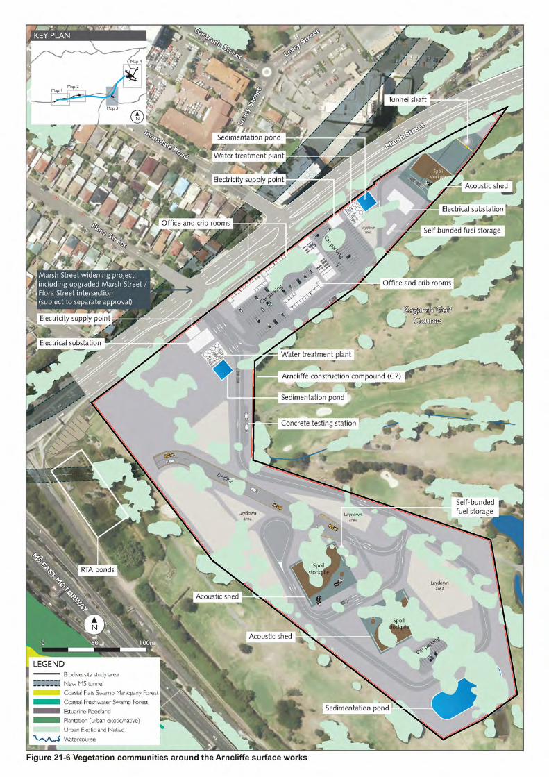
Vegetation cover Around 103 hectares of native vegetation is located within the biodiversity study area, accounting for about eight per cent of the total footprint of the study area. Vegetation communities within the biodiversity study area are shown in Figure 21-4 to Figure 21-7.
Wildlife corridors No formal state or regional biodiversity links are present within the study area. Local wildlife corridors are present, but do not meet the definition of state or regional biodiversity links. Additional detail regarding wildlife corridors is provided in Section 21.2.5.
WestConnex New M5 21-15 Roads and Maritime Services Environmental Impact Statement

21.2.2 Terrestrial flora Existing vegetation across the biodiversity study area varies in terms of extent, connectivity and quality. Most of the biodiversity study area is characterised by established suburban development, with remnant patches of vegetation associated with suburban residential properties and infrastructure corridors. Much of the vegetation around Sydney, including within the biodiversity study area, has been cleared or disturbed to varying extents. It is common for fragmented vegetation communities to be present along highways and major roads where they have been preserved as part of the road reserve or as part of riparian buffers and gully systems associated with sandstone landforms.
The most significant areas of vegetation include Wolli Creek Regional Park, to the north of the project, and Cooks River Castlereagh Ironbark Forest at the westernmost end of Beverly Grove Park, Beverly Hills.
The biodiversity study area spans all four surface water sub-catchments of the Cooks River catchment; the Cooks River, Alexandra Canal, Eastern Channel and Wolli Creek sub-catchments (refer to Figure 16-1). Surface water quality across the biodiversity study area is variable as a result of the suburban nature of the surface water catchments, with the quality of water, watercourses and riparian areas influenced by the extent of adjacent development. Further discussion of surface water quality is provided in Chapter 16 (Soils and water quality).
Vegetation communities Native vegetation communities
Vegetation communities within the biodiversity study area were identified through database searches and literature reviews, and verified through field surveys carried out for the project (refer to Section 21.1.4). Four plant community types as defined by the OEH vegetation information system database were identified in the biodiversity study area:
• Broad-leaved Ironbark Melaleuca decora shrubby open forest on the clay soils of the Cumberland Plain, Sydney Basin Bioregion (Broad-leaved Melaleuca decora shrubby open forest)
• Paperbark Swamp Forest of the Coastal Lowlands of the NSW North Coast Bioregion and Sydney Basin Bioregion (Paperbark Swamp Forest)
• Turpentine Grey Ironbark open forest on shale in the Sydney Basin (Turpentine Grey Ironbark Forest)
• Smooth-barked Apple - Red Bloodwood - Sydney Peppermint heathy open forest in sandstone gullies of western Sydney, Sydney Basin (Smooth-barked Apple - Red Bloodwood - Sydney Peppermint heathy open forest).
The vegetation communities mapped within the biodiversity study area are shown in Figure 21-4 to Figure 21-7.
Some areas could not be accessed during ecological field surveys because they are located on private property. Vegetation on private properties has not been verified through field surveys, but is expected to contain limited native vegetation communities. It is expected that most flora within areas that have not been verified would largely contain planted or managed vegetation.
WestConnex New M5 21-16 Roads and Maritime Services Environmental Impact Statement


(blank page)
WestConnex New M5 21-18 Roads and Maritime Services Environmental Impact Statement

Threatened ecological communities
As summarised in Table 21-3, three of the four vegetation communities identified in the biodiversity study area are associated with threatened ecological communities. Specifically:
• Vegetation mapped as Broad-leaved Melaleuca decora shrubby open forest around the westernsurface works area meets the EPBC Act and TSC Act definition of Cooks River CastlereaghIronbark Forest in the Sydney Basin Bioregion (Cooks River Castlereagh Ironbark Forest) (refer to Figure 21-4). Cooks River Castlereagh Ironbark Forest is listed as a critically endangeredecological community under the EPBC Act and an endangered ecological community under theTSC Act
• Turpentine Grey Ironbark Forest, also known as Sydney Turpentine Ironbark Forest is athreatened ecological community, listed as a critically endangered ecological community under the EPBC Act and an endangered ecological community under the TSC Act. Patches of Sydney Turpentine Ironbark Forest have been mapped as occurring south of the Kingsgrove Southconstruction compound (C2) within Beverly Hills Park and within Canterbury Golf Course (refer to Figure 21-4). These patches of vegetation did not meet the threshold criteria to be identifiedas a threatened ecological community under the EPBC Act, due to their small size of only 0.6 hectares. The vegetation did, however, meet the definition of this community under the TSC Act.
• Paperbark Swamp Forest is a component of Swamp Sclerophyll Forest on Coastal Floodplains of the NSW North Coast, Sydney Basin and South East Corner bioregions (Swamp Sclerophyll Forest), listed as an endangered ecological community under the TSC Act. Paperbark SwampForest is located within the biodiversity study area around the Arncliffe surface works within theKogarah Golf Course between the fairways. This vegetation is under-scrubbed with a clear understorey and exotic groundcover, consistent with vegetation management on golf coursefairways. Given the extent of clearing of the understorey, vegetation classified as paperbark swamp forest within the biodiversity study area does not meet the threshold criteria to beidentified as the Swamp Sclerophyll Forest threatened ecological community.
Other vegetation communities Areas of planted native, introduced and exotic species (urban native and exotic vegetation) have been mapped within parklands and areas of open space adjacent to the M5 East Motorway. Around 7.45 hectares of urban native and exotic vegetation has been mapped across the biodiversity study area. Mapped areas of urban native and exotic vegetation are shown in Figure 21-4 to Figure 21-7.
Urban native and exotic vegetation within the biodiversity study area is typically located in areas where the soil profile has been modified. Urban native and exotic vegetation within parklands, including playground and maintained sports fields generally comprises large established trees, with no shrub layer or evidence of regenerating overstorey species. Vegetated areas adjacent to the M5 East Motorway mapped as urban native and exotic vegetation primarily consists of regenerating canopy species above a shrub layer but with no large established trees.
WestConnex New M5 21-19 Roads and Maritime Services Environmental Impact Statement

Table 21-3 Native vegetation communities within the biodiversity study area
Plant community type
Associated threatened ecological community Description of vegetation community within biodiversity study area
Threatened ecological community
EPBC Act listing
TSC Act listing
EEC present in biodiversity study area Location Area (ha)
Condition
Broad-leaved Ironbark Melaleuca decora shrubby open forest
Cook River Castlereagh Ironbark Forest
CE E Yes. Vegetation community meets the threshold criteria to be identified as a threatened ecological community under the EPBC Act and the TSC Act.
Area around the western surface works (refer to Figure 21-4)
1.4 Moderate to good
Paperbark swamp forest
Swamp Sclerophyll Forest on Coastal Floodplains of the NSW North Coast, Sydney Basin and South East Corner bioregions
N/A E No. Vegetation within the biodiversity study area does not meet the threshold criteria to be identified as a threatened ecological community under the TSC Act. This vegetation community is not listed under the EPBC Act
Area around the Arncliffe surface works (refer to Figure 21-6)
1.82 Moderate to good
Turpentine Grey Ironbark open forest *
Sydney Turpentine Ironbark Forest
CE E One patch of Sydney Turpentine Ironbark Forest was identified in the biodiversity study area assessment buffer, outside of the worst case construction and operational footprints. The patch did not meet the threshold criteria to be identified as a threatened ecological community under the EPBC Act, due to its small size of only 0.6 hectares but it did meet the TSC Act definition.
South of the M5 East Motorway, outside of the worst case construction and operational footprints, but within the assessment buffer (refer to Figure 21-4)
0 Moderate to good
Smooth-barked Apple - Red Bloodwood Sydney Peppermint heathy open forest
NA N/A N/A This vegetation community is not listed under the TSC Act or the EPBC Act.
Area around the Bexley surface works (refer to Figure 21-5)
0.09 Moderate to good
CE – critically endangered, E – endangered *Sydney Turpentine Ironbark Forest is located within the 550 metre biodiversity assessment buffer but outside of the construction and operational footprint
WestConnex New M5 Roads and Maritime Services Environmental Impact Statement
21-20


(blank page)
WestConnex New M5 21-22 Roads and Maritime Services Environmental Impact Statement


(blank page)
WestConnex New M5 21-24 Roads and Maritime Services Environmental impact statement

(blank page)
WestConnex New M5 21-26 Roads and Maritime Services Environmental impact statement


(blank page)
WestConnex New M5 21-28 Roads and Maritime Services Environmental Impact Statement

Threatened flora
A database search of the EPBC Protected Matters Search Tool and the NSW Wildlife Atlas identified 50 threatened flora species and four threatened flora populations listed as vulnerable, endangered or critically endangered under the EPBC Act and / or TSC Act as occurring or potentially occurring within 10 kilometres of the project. A full list of these species is provided in Technical working paper: Biodiversity (Appendix S).
In accordance with the FBA methodology, no threatened flora species were identified in the credit calculator as ecosystem credit species. The credit calculator identified 22 threatened flora species and three threatened flora populations as candidate species, in accordance with the FBA (refer to Section 21.1.1 for additional detail). These species and populations and their conservation status under the EPBC and / or TSC Act and are listed in Table 21-4.
Persoonia hirsuta (Hairy Geebung), Pimelia spicata (Spiked Rice-flower) and Tetratheca juncea (Black-eyed Susan), have been specified in the Commonwealth guidelines for the project (refer to Appendix A) as potentially being at risk from the project. However, the field surveys undertaken as part of the biodiversity assessment did not record these species within the biodiversity study area. Further, any potential habitat present within the biodiversity study would be highly modified and unlikely to support these species. As such, these species are not considered likely to occur and therefore excluded from Table 21-4.
The identified candidate species were compared against the habitat features present within the biodiversity study area to determine whether the species are likely to be present and subsequently if there is a requirement for a targeted survey to be conducted. Field surveys did not record any threatened flora species or populations within the biodiversity study area. No candidate species listed in Table 21-4 are likely to occur in the biodiversity study area due to the degraded condition of the vegetation. In accordance with the FBA methodology, these species were excluded from further consideration and assessment.
Table 21-4 Threatened flora species and populations with the potential to occur within the biodiversity study area
Scientific Name Common Name Statutory listing EPBC Act TSC Act
Threatened flora Acacia bynoeana Bynoes Wattle V E Acacia pubescens Downy Wattle V V Caladenia tessellata Thick Lip Spider Orchid V E Callistemon linearifolius Netted Bottle Brush - V Darwinia biflora - V V Dillwynia tenuifolia - - V Epacris purpurascens var. purpurascens - - V Grammitis stenophylla Narrow-leaf Finger Fern - E Grevillea parviflora subsp. parviflora Small-flower Grevillea V V Gyrostemon thesioides - - E Haloragodendron lucasii - E E Hibbertia puberula - - E Hibbertia sp. Bankstown - CE CE Hibbertia superans - - E Leucopogon exolasius Woronora Beard Heath V V Maundia triglochinoides - - V Melaleuca deanei Deanes Paperbark) V V Persoonia nutans Nodding Geebung E E Pimelea curviflora subsp. curviflora NA V V Pterostylis saxicola Sydney Plains Greenhood E E Syzygium paniculatum Magenta Lilly Pilly V E Tetratheca glandulosa - - V
WestConnex New M5 21-29 Roads and Maritime Services Environmental impact statement

Scientific Name Common Name Statutory listing EPBC Act TSC Act
Threatened flora populations Acacia prominens (Gosford wattle) population, Hurstville and Kogarah local government areas
- E
Plum-leaf Pomaderris population, Parramatta, Auburn, Strathfield and Bankstown Local Government Areas
- E
Wahlenbergia multicaulis (Tadgells Bluebell) population, Auburn, Bankstown, Baulkham Hills, Canterbury, Hornsby, Parramatta and Strathfield local government areas
- E
CE = critically endangered, E = endangered, V = vulnerable
Exotic species
Field surveys carried out for the project (refer to Section 21.1.4) identified abundant weeds within the biodiversity study area, with some areas containing prolific weed infestations. A total of 38 weed species were recorded across the biodiversity study area. Of these, 14 noxious and environmental weeds were identified and are summarised in Table 21-5.
A comprehensive list of weeds identified within the biodiversity study area is provided in the Technical working paper: Biodiversity (Appendix S).
Table 21-5 Noxious and environmental weeds identified during field surveys
Scientific name Common name Listed as noxious in local government areas
Class* Weed of National Significance
Acetosa sagittata Turkey Rhubarb - Araujia sericifera Moth Vine - Asparagus aethiopicus
Asparagus Fern Canterbury and Rockdale 4
Cestrum parqui Green Cestrum Canterbury and Rockdale 3 Cinnamomum camphora
Camphor Laurel -
Cotoneaster glaucophyllus
Cotoneaster -
Erythrina crista-gall Cockspur Coral Tree - Ipomoea indica Morning Glory - Lonicera japonica Japanese Honeysuckle - Lantana camara Lantana Canterbury and Rockdale 4 Ligustrum lucidum Large-leaved Privet Canterbury and Rockdale 4 Ligustrum sinense Small-leaved Privet Canterbury and Rockdale 4 Ochna serrulata Mickey Mouse Plant - Rubus fruticosus aggregate species
Blackberry Canterbury and Rockdale 4
*Noxious weeds classes as defined under the Noxious Weeds Act 1993 Class3: The plant must be fully and continuously suppressed and destroyed. Class 4: The growth of the plant must be managed in a manner that reduces its numbers spread and incidence and continuously inhibits its reproduction.
WestConnex New M5 21-30 Roads and Maritime Services Environmental impact statement

21.2.3 Terrestrial fauna Table 21-6 presents the threatened fauna species and populations with the potential to occur within the biodiversity study area. These species have been identified using the FBA credit calculator as part of the application of the FBA methodology for the project.
The FBA credit calculator identified 17 threatened fauna species as ecosystem credit species (ie species which can be reliably predicted as potentially occurring at a location based on the landscape-scale biodiversity features and plant community types present). An additional 10 threatened flora species and one threatened flora population were identified in the FBA credit calculator as species credit species; ie species which may potentially be present within the biodiversity study area, but are not able to be reliably predicted based on vegetation communities present.
The ‘likelihood of occurrence’ assessment determined that the Green and Golden Bell Frog (Litoria aurea) is the only threatened species known to occur in the biodiversity study area. No other threatened fauna are likely to occur in the biodiversity study area due to the limited and degraded nature of suitable habitat present.
WestConnex New M5 21-31 Roads and Maritime Services Environmental impact statement

Table 21-6 Threatened fauna species and populations with the potential to occur within the biodiversity study area
Scientific Name Common Name Statutory listing FBA Species type
EPBC Act TSC Act Ecosystem credit
Species credit
Threatened fauna Anthochaera phrygia Regent Honeyeater CE CE Burhinus grallarius Bush Stone Curlew - E Callocephalon fimbriatum Gang-gang Cockatoo - V Cercartetus nanus Eastern pygmy possum - V Chalinoblus dwyeri Large-eared Pied Bat V V Chthonicola sagittata Speckled Warbler - V Climacteris picumnus victoriae Brown Treecreeper (eastern subspecies) - V Daphoenositta chrysoptera Varied Sittella - V Falsistrellus tasmaniensis Eastern False Pipistrelle - V Glossopsitta pusilla Little Lorikeet - V Grantiella picta Painted Honeyeater V V Hieraaetus morphnoides Little Eagle - V Hoplocephalus bungaroides Broad-headed Snake V E Lathamus discolour Swift Parrot E E Litoria aurea Green and Golden Bell Frog V E Melanodryas cucullata cucullata Hooded Robin (south-eastern form) - V Melithreptus gularis gularis Black-chinned Honeyeater (eastern subspecies) - V Meridolum corneovirens Cumberland Plain Land Snail V E Mormopterus norfolkensis Eastern Freetail-bat - V Petaurus norfolcensis Squirrel Glider - V Phascolarctos cinereus Koala V V Pseudomys novaehollandiae New Holland Mouse V - Pseudophryne australis Red-crowned Toadlet - V Saccolaimus flaviventris Yellow-bellied Sheathtail-bat - V Scoteanax rueppellii Greater Broad-nosed Bat - V Stagonopleura guttata Diamond Firetail - V Varanus rosenbergi Rosenberg’s Goana - V Threatened fauna populations Gang-gang Cockatoo population, Hornsby and Ku-ring-gai Local Government Areas (LGAs) NA E CE = critically endangered, E = endangered, V = vulnerable
WestConnex New M5 21-32 Roads and Maritime Services Environmental impact statement

Terrestrial fauna habitat
The following section provides a description of flora and fauna habitats within the biodiversity study area. No critical habitat has been declared for any of the species or ecological communities within the biodiversity study area.
Grey-headed Flying Fox habitat
Grey-headed Flying Fox (Pteropus poliocephalus) roosting camps are generally located within 20 kilometres of a regular food source and are commonly found in gullies, close to water, in vegetation with a dense canopy (DECCW, 2009b). Individual camps may have tens of thousands of animals and are used for mating, birth and the rearing of young.
No Grey-headed Flying Fox breeding or roosting habitat is located within the construction and operational footprint of the project. The closest Grey-headed Flying Fox camp is located about 500 metres north of the Bexley Road surface works.
Grey-headed Flying Foxes feed on the nectar and pollen of native trees, in particular Eucalyptus, Melaleuca and Banksia, and fruits of rainforest trees and vines. They also forage in cultivated gardens and fruit crops and can inflict severe crop damage (DECCW, 2009b). Native vegetation communities within the biodiversity study area (refer to Section 21.2.2) provide potential foraging habitat for the Grey-Headed Flying Fox. No potential breeding or foraging habitat is located within the biodiversity study area.
Hollow bearing trees
Nine trees within the biodiversity study area were identified as containing hollows, as summarised in Table 21-7. These trees were scattered throughout the biodiversity study area around the western surface works, Bexley Road surface works and the local road upgrades.
WestConnex New M5 21-33 Roads and Maritime Services Environmental impact statement

Table 21-7 Hollow bearing tree survey results
ID Location Hollow type
Potential fauna
Evidence of use
TBH* (cm)
Notes
1 Around the western surface works area
Fissure Bat No 110 One possible hollow was recorded during field surveys. There is the potential for additional smaller hollows to be present.
2 Around the western surface works area
Hole on branch/ fissure
Bat No 110 One hollow was recorded about six metres from the ground level. There is the potential for additional smaller hollows to be present.
3 Around the Bexley Road surface works area
Fissure Bat, small bird
No 140 One hollow about one metre from the ground level and a split trunk were recorded during the field survey. Tree hollow was identified as being unlikely to be used.
4 Around the Bexley Road surface works area
Nest box Possum No 75 One nest box recorded on the tree. The nest box was recorded as being just outside the construction and operational footprint.
5 Around the local road upgrades
Branch Small bird No 70 One possible hollow was recorded during field surveys about three metres above ground level. The possible hollow was recorded as being unlikely to be used.
6 Around the local road upgrades
Branch (dead)
Bat No 60 The hollow may be a branch hollowed out by termites; however, this hollow is low-lying and unlikely to be used
7 Around the local road upgrades
Spout Medium bird or possum
Possible 90 Possible scratches and chew marks recorded on tree. Presence of hollow was unconfirmed.
8 Around the local road upgrades
Spout Bat Unknown 40 Potential for hollow to be present in tree spout. This was unconfirmed during field surveys.
9 Around the local road upgrades
Trunk / fissure
Possum, bat, small bird
Unknown 120 Dual trunk tree, which could potentially be used by fauna. Presence of hollow unconfirmed during field surveys.
TBH – Tree diameter at breast height
WestConnex New M5 21-34 Roads and Maritime Services Environmental impact statement

21.2.4 Green and Golden Bell Frog key population and habitat The Green and Golden Bell Frog (Litoria aurea) Key Population of the Lower Cooks River (the Arncliffe key population) is located within the construction and operational footprint of the project at the Kogarah Golf Course, Arncliffe. The Arncliffe key population is one of two key populations around Botany Bay, and one of four in south-eastern Sydney. The Arncliffe key population around the Marsh Street wetlands was previously the subject of major road works and infrastructure development associated with the construction of the M5 East motorway in 1998. Compensatory habitat in the form of two breeding ponds (the RTA Ponds) were established in the north-western corner of Kogarah Golf Course on Roads and Maritime land and a frog underpass connecting the new breeding ponds with Marsh Street wetlands was also established. In addition, a long-term monitoring and management program was established and is still operating successfully.
Monitoring of the Arncliffe key population has been undertaken by Dr. Arthur White since 1998, with regular annual monitoring undertaken from 2004 onwards. This monitoring has indicated that the population centres around the compensatory habitat at the Kogarah Golf Course. Green and Golden Bell Frog habitat within the construction and operational footprint is shown on Figure 21-8. Adult Green and Golden Bell Frogs have been recorded at the Kogarah Golf Course during each annual monitoring period, with recordings concentrated mostly around the fifth and six fairways, and Crescent Lake. Annual monitoring results from 2004 to 2015 indicate that the Arncliffe key population was at its largest in 2012 with 110 adults recorded. In the 2014 / 2015 monitoring period, the Arncliffe key population was estimated to be around 30 to 50 adults. The current population is unlikely to persist without constant management and is considered to have poor long-term viability (White pers. comms, 2015).
The current population is limited to the RTA Ponds by the presence of the Plague Minnow (Gambusia holbrooki), an introduced fish species which eats frogspawn and attacks the tadpoles of native frog species, and the chytrid fungus, which infects frogs causing the disease ‘Chytridiomycosis’, both of which are located in nearby waterbodies. The infection of frogs with the chytrid fungus is listed as a key threatening process under the EPBC Act and TSC Act and is discussed further in Section 21.3.1. Regular maintenance is undertaken within the RTA Ponds to manipulate the water levels to manage vegetation and Green and Golden Bell Frog predators, namely the Plague Minnow. Additionally, the RTA ponds are regularly subject to salt water flushing to manage and prevent the introduction and spread of the chytrid fungus at this location.
Monitoring of the Arncliffe key population identified that the population is centred around the artificially created RTA Ponds and breeding has not been identified outside this area since 2000 (White pers. comms, 2015). The RTA Ponds are considered to be the key source for adult frogs for the local population, which disperse across the Kogarah Golf Course. Kogarah Golf Course contains a range of habitats for the Green and Golden Bell Frog, which are summarised in Table 21-8.
Table 21-8 Green and Golden Bell Frog habitat types within Kogarah Golf Course
Habitat type Breeding habitat
Description The permanent and semi-permanent RTA Ponds in the north-western corner of the Kogarah Golf Course. Two other ponds within the golf course have provided breeding habitat, although breeding events are rare, presumably due to predation by the Plague Minnow (Gambusia holbrooki). The key source of adults and juveniles are the RTA Ponds (which are actively managed for Plague Minnow and chytrid fungus by Roads and Maritime)
Foraging habitat Native and exotic grassed areas, tussock vegetation and emergent sedges and reeds which border the RTA Ponds, as well as the drainage channel and reed beds along the southern boundary of the golf course.
Sheltering habitat Areas around the RTA Ponds, consisting of foraging habitat as well as rock piles, fallen timber, and other sheltering sites.
Dispersal habitat The Kogarah Golf Course fairways provide movement habitat between breeding and foraging habitat. There is an artificial frog passage that travels under the M5 East Motorway to facilitate movement between the Kogarah Golf Course and the Marsh Street wetland, which is not regularly used (DECC, 2008b). .
WestConnex New M5 21-35 Roads and Maritime Services Environmental impact statement

(blank page)
WestConnex New M5 21-36 Roads and Maritime Services Environmental impact statement


(blank page)
WestConnex New M5 21-38 Roads and Maritime Services Environmental impact statement

21.2.5 Wildlife corridors Wildlife corridors are connections across the landscape that link areas of habitat. Wildlife corridors generally comprise native vegetation and connect two or more areas of similar wildlife habitat. Corridors are critical for the maintenance of ecological processes, including allowing for the movement of animals and the continuation of viable ecological processes. Landscape connections between larger areas of habitat through wildlife corridors enable migration, colonisation and breeding of flora and fauna.
Corridors can comprise either discontinuous areas of habitat, such as wetlands and roadside vegetation, continuous lineal strips of vegetation and habitat, such as riparian strips and ridge lines, or parts of a larger habitat area selected for its known or likely importance to local fauna.
Based on their ecological value, the following areas are considered to have potential functionality as local scale wildlife corridors:
• Vegetation along Wolli Creek, including Wolli Creek Regional Park
• Vegetation along the F6 reserved road corridor, including the Eve Street Marsh
• Vegetation along Bardwell Creek, including Kingsgrove Park, Bardwell Valley Parklands, Broadford Street Reserve and Coolibah Reserve
• Vegetation along the Cooks River north of its confluence with Wolli Creek, including parts of Wentworth Park and Gough Whitlam Park.
While the abovementioned corridors provide local connectivity, they do not represent regional and/ or state significant corridors of significance. No regional or state wildlife corridors have been identified within the biodiversity study area.
21.2.6 Aquatic biodiversity Aquatic habitat
Three principal watercourses traverse or are located in the vicinity of the biodiversity study area:
• Wolli Creek (passed under by the main alignment tunnels)
• The Cooks River (passed under by the main alignment tunnels)
• Alexandra Canal (crossed by two bridges as part of the local road upgrades)
All watercourses within the biodiversity study area are declared as Key Fish Habitat by the New South Wales Department of Primary Industries. The condition and aquatic habitats for each watercourse are outline in the following sections. Additional detail regarding the local and regional hydrology of the project is provided in Chapter 16 (Soils and water quality).
There are no wetlands protected under State Environmental Planning Policy No 14 – Coastal Wetlands (SEPP 14) within or nearby the biodiversity study area. The closest Ramsar wetland to the project is the Towra Point Nature Reserve, about nine kilometres south of the biodiversity study area.
In addition to natural watercourses, constructed detention basins and artificial waterbodies provide potential habitat for aquatic flora and fauna, including wetland species. The primary purpose of detention basins is to slow stormwater flows to minimise water pollution and impacts to the hydrology of receiving waters. As the detention basins are isolated, they are unlikely to be inhabited by fish, though other fauna may be found at these locations.
The Sydney Water Environmental Indicators Compliance Report Volume 3 (Woodlots, 2004) provided a comparison between Wolli Creek, Alexandra Canal and Cooks River, classifying them as highly disturbed systems in relation to the ANZECC Water Quality Guidelines (ANZECC, 2000). Results indicated poor water quality overall with a number of parameters failing to comply with respective guidelines (refer to Section 16.2.7 for additional detail).
WestConnex New M5 21-39 Roads and Maritime Services Environmental impact statement

Threatened aquatic flora and fauna
Six threatened species / populations listed under the EPBC Act and / or FM Act potentially occur in the Sydney Metropolitan catchment area, excluding marine sharks (discussed collectively as part of migratory and marine fauna). This includes:
• Two dragonflys with an aquatic life history stage, The Sydney Hawk dragonfly (Austrocordulia leonardi) and Adam’s Emerald Dragonfly (Archaeophya adamsi). These two species of dragonfly are unlikely to occur in the study area as they have only been recorded in creeks with intact riparian / aquatic vegetation and in forested catchments
• One migratory fish; the Australian Grayling (Protoroctes maraena). The Australian Grayling uses good quality, freshwater habitat, which is not present in the biodiversity study area or in associated upstream catchments of the Cooks River and Wolli Creek
• One coastal/estuarine fish, the Black Rock Cod (Epinephelus daemelii). The black rockcod prefers rocky shores, caves and reefs which are not present in the biodiversity study area
• One coastal/estuarine ray, the Green Sawfish (Pristis zijsron), which is presumed extinct
• A population of the seagrass Posidonia australis occurs in southern Botany Bay (Fisheries NSW), but is not known to occur within or near the biodiversity study area.
Although some marine vegetation occurs in Wolli Creek and Cooks River, no seagrass, mangroves or saltmarsh were observed in the study area during land-based surveys of Wolli Creek, Cooks River and Alexandra Canal. The proposed crossings across Alexandra Canal near the St Peters interchange and local road upgrades. The contaminated and degraded nature of the canal means that it is unlikely to be viable habitat for seagrasses and other aquatic flora and fauna.
21.2.7 Groundwater dependent ecosystems Groundwater dependent ecosystems (GDEs) are defined as ecosystems whose current species composition, structure and function are reliant on a supply of groundwater as opposed to surface water supplies from overland flow paths. The majority of ecosystems in Australia have little to no dependence on groundwater, although the full understanding of the role of groundwater in maintaining ecosystems is generally poor. The exception to this is wetland communities, for which it is thought that most have some level of dependence on groundwater resources. Shallow groundwater can support riparian vegetation either permanently or seasonally. Groundwater needs to be sufficiently shallow to support vegetation where root systems of vegetation communities are able to access groundwater.
A search of the GDE Atlas (Bureau of Meteorology) indicated that there are two GDEs within the biodiversity study area. GDEs within the biodiversity study area include:
• Cooks River Castlereagh Ironbark Forest within Beverly Grove Park. There is about 1.8 hectares of this threatened ecological community, containing several native vegetation communities which are indicative of shallow groundwater tables and waterlogged soils. The GDE Atlas marks the Cooks River Castlereagh Ironbark Forest as being highly likely to have an inflow dependence on groundwater. The extent of this vegetation community is shown on Figure 21-4
• The Cooks River, which is likely to be an inflow dependent GDE.
An additional three groundwater dependent ecosystems have been identified outside of the biodiversity study area, but within the extent of land impacted by groundwater drawdown:
• Seventeen hectares of Hinterland Sandstone Gully Forest with a moderate to high potential to be dependent on groundwater within Bardwell Valley Parkland and Broadford Street Reserve
• About 3.5 hectares of Coastal Sandstone Ridgetop Woodland within Stotts Reserve, Bexley North. This vegetation has a moderate to high potential to be dependent on groundwater
• About 3.4 hectares of Estuarine Fringe Forest between the southern bank of Wolli Creek and the rail line behind Wolli Creek Station, with a low to moderate potential to be dependent on groundwater
WestConnex New M5 21-40 Roads and Maritime Services Environmental impact statement

GDEs within the biodiversity study area and within the extent of land impacted by groundwater drawdown are shown on Figure 21-9.
Additional detail regarding existing groundwater conditions in the biodiversity study area is discussed in Chapter 19 (Groundwater).
Other native vegetation has been identified within the project groundwater drawdown modelling extent; however, the vegetation is not considered to be associated with a dependence on groundwater. These areas include:
• Landing lights, Eve Street and Marsh Street wetlands, which are all located in alluvium
• Tempe wetlands near Alexandra Canal – the canal is tidal and associated with tidal flows along the Cooks River.
WestConnex New M5 21-41 Roads and Maritime Services Environmental impact statement

(blank page)
WestConnex New M5 21-42 Roads and Maritime Services Environmental impact statement


(blank page)
WestConnex New M5 21-44 Roads and Maritime Services Environmental impact statement

21.3 Assessment of potential impacts Impacts to terrestrial and aquatic flora and fauna within the biodiversity study area during construction and operation of the project may include:
• Impacts on vegetation communities and threatened ecological communities
• Impacts on threatened flora, threatened fauna or their habitats
• Impacts on migratory and marine species
• Impacts to hydrology and aquatic biodiversity, and permanent changes to hydrology
• Introduction and spread of weeds, pathogens and animal pests
• Fauna injury and mortality
• Disruption of wildlife connectivity and increased habitat fragmentation
• Impacts on groundwater dependent ecosystems
• Indirect impacts from noise and vibration, lighting and dust
• Impacts on relevant key threatening processes.
An assessment of the potential impacts of the project during construction and operation are detailed in Section 21.3.1 and Section 21.3.2 respectively. Environmental management measures to avoid, minimise, mitigate and offset these impacts are discussed in Section 21.4.
21.3.1 Construction The project has been designed with the aim of avoiding impacts to known areas of ecological sensitivity, where feasible. However, some impacts on areas of ecological sensitivity were unavoidable. An assessment of the potential impacts of the project on biodiversity during construction of the project is described in the following sections.
Impacts on vegetation communities and threatened ecological communities Clearance of vegetation would be unavoidable due to the required footprint of the project. Notwithstanding, opportunities to avoid and minimise the extent of vegetation clearing would continue to be considered during detailed design of the project.
For the purpose of this assessment, a worst case construction footprint has been assumed (which is larger in area than the subsequent operational footprint for the project). The project would require the clearance of around 10.76 hectares of vegetation, including 3.31 hectares of native vegetation and 7.45 hectares of urban native and exotic vegetation.
Table 21-9 provides a breakdown of the vegetation communities that would be directly impacted by the worst case construction footprint.
WestConnex New M5 21-45 Roads and Maritime Services Environmental impact statement

Table 21-9 Directly impacted vegetation within the biodiversity study area
Plant community type Threatened ecological community associated with
plant community type
EPBC Act
listing
TSC Act
listing
Area (ha)
Broad-leaved Ironbark Melaleuca decora shrubby open forest on the
clay soils of the Cumberland Plain, Sydney Basin Bioregion
Cooks River Castlereagh Ironbark Forest
CE E 1.40
Paperbark swamp forest of the coastal lowlands of the NSW North
Coast Bioregion and Sydney Basin Bioregion
Swamp Sclerophyll Forest on Coastal Floodplains of the
NSW North Coast, Sydney Basin and South East Corner bioregions
NA E 1.82
Smooth-barked Apple - Red Bloodwood - Sydney Peppermint
heathy open forest in sandstone gullies of western Sydney, Sydney
Basin
NA NA NA 0.09
Total native vegetation (hectares) 3.31 Urban native and exotic vegetation N/A N/A N/A 7.45
Total vegetation to be removed (hectares) 10.76
CE – critically endangered, E – endangered
Cooks River Castlereagh Ironbark Forest community About 1.87 hectares of Cooks River Castlereagh Ironbark Forest (as defined under the TSC Act and EPBC Act) is located within and adjacent to the Kingsgrove North construction compound (C1) site within Beverly Grove Park. This patch of vegetation is currently managed for conservation purposes by Roads and Maritime.
Vegetation at this location meets the definition of the Cooks River Castlereagh Ironbark Forest threatened ecological community under the TSC Act and EPBC Act as it:
• Occurs in the Interim Biogeographic Regionalisation for Australia (IBRA) Cumberland Subregion at less than 100 metres above sea level
• Contains native flora species representative of clay and shale influenced soils
• Contains representative species across all vegetation layers including the Prickly-leaved Paperbark (Melaleuca nodosa), White Feather Honeymyrtle (Melaleuca decora), Woollybutt (Eucalyptus longifolia), Green Wattle (Acacia decurrens), Bursaria spinosa, Wiry Panic (Entolasia stricta) and Weeping Grass (Microlaena stipoides)
• Is greater than the minimum patch size area (0.5 hectares) and more than 50 per cent of the perennial understorey vegetation cover comprises native species.
It is estimated that 1828 hectares of Cooks River Castlereagh Ironbark Forest remains in existence within the Sydney Basin bioregion (Tozer et al, 2006, 2010). The project is anticipated to require the clearing of 1.4 hectares of Cooks River Castlereagh Ironbark Forest, which is equivalent to less than 0.1 per cent of the estimated remaining remnant area of this community within the Sydney Basin Bioregion.
A detailed assessment of the significance of clearing up to 1.4 hectares of Cooks River Castlereagh Ironbark Forest is presented in the Technical working paper: Biodiversity (Appendix S). The assessment of significance against the EPBC Act significant impact criteria (Commonwealth Department of the Environment, 2015) determined that despite the provision of mitigation measures, there is likely to be a significant impact on this threatened ecological community. This reflects the limited remaining areas of this community within the Sydney Basin bioregion and its status as a critically endangered ecological community under the EPBC Act and as an endangered ecological community under the TSC Act.
WestConnex New M5 21-46 Roads and Maritime Services Environmental impact statement

Impacts to the Cooks River Castlereagh Ironbark Forest threatened ecological community would be offset in accordance with the FBA. Additional information regarding the biodiversity offsets strategy for the project is provided in Section 21.4.1 and Appendix T.
Impacts on threatened flora As discussed in Section 21.2.2, the FBA credit calculator predicted that 24 threatened flora species and three threatened fauna populations are potentially associated with vegetation communities present in the biodiversity study area. No threatened flora species or populations were recorded within the construction and operational footprints of the project during field surveys. Impacts to threatened flora species and populations are therefore not anticipated as a result of the project.
The following species listed under the EPBC Act have been identified by the Commonwealth Department of the Environment as occurring or potentially occurring within the region:
• Bynoe’s Wattle (Acacia bynoeana)
• Downy Wattle (Acacia pubescens)
• Deane’s Paperbark (Melaleuca deanei)
• Hairy Geebung (Persoonia hirsuta)
• Spiked Rice-flower (Pimelea spicata)
• Magenta Lilly Pilly (Syzygium paniculatum)
• Black-eyed Susan (Tetratheca juncea).
The project is not anticipated to impact these species as suitable areas of potential habitat that are to be cleared within the biodiversity study area are degraded or have been substantially modified and are unlikely to support these species. Targeted surveys conducted as part of the field survey program did not record these species within the biodiversity study area.
Impacts on threatened fauna
The FBA credit calculator identified 17 threatened fauna species as ecosystem credit species (ie species which can be reliably predicted as potentially occurring at a location based on the landscape-scale biodiversity features and plant community types present (refer to Section 21.2.3). The ‘likelihood of occurrence’ assessment determined that these species are unlikely to be present in the biodiversity study area due to the limited and degraded nature of suitable habitat present.
As discussed in Section 21.2.3, the Green and Golden Bell Frog (Litoria aurea) is the only threatened species known to occur in the biodiversity study area. No other threatened fauna are likely to occur in the biodiversity study area.
The project would remove up to 7.82 hectares of foraging, dispersal and sheltering habitat for the Arncliffe key population at Kogarah Golf Course. The breeding habitat provided by the RTA Ponds (refer to Section 21.2.4) would not be directly disturbed by the project, and a buffer/ exclusion zone of around 32 metres would be provided between the RTA Ponds and the Arncliffe construction compound.
The removal of foraging, dispersal and sheltering habitat would decrease the viability of the population at this location. Although previous records have identified individual frogs located at the Marsh Street and Eve Street wetlands there have not been any record of frogs breeding in these habitats suggesting that these habitats are unsuitable.
Impacts to the Green and Golden Bell Frog key population at Arncliffe are expected to be temporary for the duration of construction. Land to be used for construction and not within the footprint of the Arncliffe motorway operations complex (MOC3) would be rehabilitated at the completion of construction. This rehabilitation would take into account the habitat requirements of the Green and Golden Bell Frog.
WestConnex New M5 21-47 Roads and Maritime Services Environmental impact statement

Impacts to the RTA Ponds as a result of noise, lighting and dust during construction are described below (refer to relevant sections). Noise, lighting and dust impacts would be temporary and are unlikely to have a significant impact on the Arncliffe Key Population with the implementation of specific mitigation measures to manage these impacts as part of the Green and Golden Bell Frog Plan of Management. No residual impacts to the Arncliffe Key Population are anticipated as a result of noise, lighting and dust.
Several mitigation and management measures have been developed and would be implemented to minimise impacts to the Green and Golden Bell Frog population, including a program to create additional breeding habitat at Marsh Street and the establishment of a captive breeding program. These mitigation measures have been included as part of a Green and Golden Bell Frog Plan of Management. The Green and Golden Bell Frog Plan of Management includes mitigation and management measures to be implemented to minimise impacts associated with construction and operation of the project. The Green and Golden Bell Frog Plan of Management includes:
• Management measures to be implemented at the Arnciffe construction compound (C7) and RTA Ponds to minimise and manage impacts to the Green and Golden Bell Frog habitat and key population during construction.
• Management measures relating to the enhancement of existing habitat at the Marsh Street Wetland
• Supplementary management measures for consideration to mitigate and minimise impacts to the Green and Golden Bell Frog.
Impacts on migratory and marine species Based on database searches and literature reviews, 63 migratory and marine species protected under the EPBC Act and the international agreements of the China-Australia Migratory Bird Agreement (CAMBA), the Japan-Australia Migratory Bird Agreement (JAMBA) and the Republic of Korea-Australia Migratory Bird Agreement (ROKAMBA) have been identified as having been previously recorded within 10 kilometres of the biodiversity study area. A comprehensive list of these species is provided in Appendix A of the Technical working paper: biodiversity (Appendix S).
Suitable habitat for migratory and marine species is not present or is unlikely to be present within the biodiversity study area. Further, impacts to aquatic habitat downstream of the project are not expected. As such, impacts to migratory and marine species from construction of the project are unlikely.
Impacts to threatened fauna habitat No critical habitat within the biodiversity study area for any listed threatened species, communities or populations.
There is known and potential threatened fauna habitat within the biodiversity study area, including for the Green and Golden Bell Frog and the Grey-headed Flying Fox, as well as hollow-bearing trees with habitat value for fauna species. Impacts to threatened fauna habitat during construction of the project are discussed in the following sections.
Impacts to Green and Golden Bell Frog habitat
The Arncliffe surface works would require the clearance of around 7.82 hectares of Green and Golden Bell Frog foraging, sheltering and dispersal habitat, equivalent to about 20 per cent of the currently available habitat within the Kogarah Golf Course. The clearance of this habitat is expected to impact on the viability of the Arncliffe key population of Green and Golden Bell Frogs. Some of this impact would be temporary during construction, with disturbed land not required for the Arncliffe motorway operations complex (MOC3) rehabilitated at the completion of construction. This rehabilitation would take into account the habitat requirements of the Green and Golden Bell Frog, with the aim of returning disturbed residual land to habitat values equivalent to or better than currently exists.
WestConnex New M5 21-48 Roads and Maritime Services Environmental impact statement

A Green and Golden Bell Frog Plan of Management has been developed to mitigate the impacts of the project on the population and its associated habitat. The plan of management includes measures to create additional habitat adjacent to the Arncliffe surface works area and to increase the amount of tussocky grasses and swales around the RTA Ponds to increase the quality of habitat. Additional information regarding the Green and Golden Bell Frog Plan of Management is provided in Section 21.4.
It is a commitment in the Green and Golden Bell Frog Plan of Management to undertake water quality monitoring of the breeding ponds. More detail on the water quality monitoring regime including frequency, sampling locations and parameters will be provided in the Habitat Creation and Captive Breeding Plan due for completion by March 2016.
Impacts to Grey-headed Flying Fox habitat While no direct impacts to known Grey-headed Flying Fox camps (roosting habitat) would occur, there would be direct impacts to potential foraging habitat for this species. About 10.76 hectares of native and exotic vegetation would be directly impacted by construction of the project. Some of the vegetation to be cleared may be used as foraging habitat by Grey-headed Flying Fox (Pteropus poliocephalus), associated with the Grey-headed Flying Fox camp at Turrella, located about one kilometre north of the Bexley Road surface works.
An assessment of significance concluded that the clearance of potential Grey-headed Flying Fox foraging habitat is unlikely to present a significant adverse impact to this species (refer Appendix G of Appendix S).
Removal of hollow bearing trees
A total of nine trees were identified as containing hollows during field surveys conducted for the project (refer to Section 21.2.3). Eight of these trees are likely to require clearance during construction. Hollows identified within the biodiversity study area are not considered large enough to provide roosting or breeding habitat for large forest owls or large cockatoos.
The removal of hollow bearing trees during construction of the project is unlikely to have an impact on threatened fauna. Pre-clearance surveys of all potential hollows would be conducted prior to clearance to ensure no fauna is present.
Impacts to hydrology and aquatic biodiversity
The project has the potential to result in temporary impacts to hydrology due to the following construction activities:
• Dewatering, treatment and discharge of groundwater during construction of the main alignment tunnels, on-ramps and off-ramps
• An increase in runoff during construction as a result of increased paved areas
• Changes to current flow regimes caused by alterations to existing detention basins and culverts, and the installation of new culverts and drainage infrastructure as part of the project
• Groundwater drawdown
Groundwater captured during construction would be pumped to four construction water treatment plants, located at:
• Kingsgrove North construction compound (C1)
• Commercial Road construction compound (C3)
• Bexley Road South construction compound (C5)
• Canal Road construction compound (C8).
Groundwater would then be treated to the 80 per cent protection level criteria as specified in the ANZECC guidelines prior to discharge to Wolli Creek, the Cooks River and Alexandra Canal (refer to Chapter 16 (Soils and water quality) for additional information).
WestConnex New M5 21-49 Roads and Maritime Services Environmental impact statement

Groundwater collected during tunnelling would be treated prior to discharge to local watercourses to meet the requirements of the environment protection licence to be issued for the project. Reference criteria for each watercourse were developed to provide guidance on the quality of water that must be produced by groundwater treatment plants to make that water suitable for discharge into the receiving environment. These criteria were defined based on available data and in accordance with the relevant ANZECC criteria.
It is expected that the environment protection licence will require the project to meet the 80 per cent protection level criteria as specified in the ANZECC guidelines (refer to Chapter 16 (Soils and water quality) for additional information).
An increase in paved areas and tunnel water discharge to local watercourses may result in increased erosion and sedimentation. Temporary controls would be implemented within construction compounds to manage erosion and sedimentation and to maintain water quality within and adjacent to construction compounds. These controls are detailed in Chapter 16 (Soils and water quality) and Chapter 18 (Surface water and flooding).
The condition of aquatic habitats downstream of the project varies from slightly modified to substantially modified. Upper reaches of watercourses are generally more heavily disturbed than further downstream. Potential impacts to aquatic habitats as a result of construction works may include:
• Groundwater discharge
• Weed invasion
• Polluted surface water runoff
• Erosion, sedimentation and increases in turbidity.
Impacts to aquatic fauna in the upper reaches of watercourses which traverse the biodiversity study area are unlikely, given the already degraded condition of these environmental and the lack of available habitat. Higher quality environments downstream could be affected during construction by:
• Increased surface water volumes and velocities, which may contribute to bank erosions and sedimentation
• Transport of weeds and nutrients, which may increase the potential for algal blooms to occur.
Impacts to aquatic habitat may also reduce the availability or desirability of habitat for macroinvertebrates.
Impacts to aquatic habitats during construction would be avoided by reducing the speed of discharge flows into watercourses, removing sediment and nutrients prior to the discharge of water into watercourses and stabilising banks, where necessary. Further information regarding these environmental management measures is provided in Chapter 16 (Soils and water quality) and Chapter 18 (Surface water and flooding).
Spread of weeds Weeds are abundant within the biodiversity study area, with some areas containing prolific weed infestations. Given the high presence of weeds in the biodiversity study area, it is likely that disturbance of vegetation could result in conditions conducive to the spread and intensification of weeds. If not appropriately mitigated and managed, this may indirectly affect native flora and fauna in adjoining areas by further reducing habitat quality, increasing competition for resources, and altering the structure and composition of vegetation communities.
The implementation of management measures outlined in Section 21.4 would minimise the potential for the spread of weeds from construction activities.
WestConnex New M5 21-50 Roads and Maritime Services Environmental impact statement

Introduction and spread of pathogens
Several pathogens of concern occur within New South Wales and have the potential to impact on native flora and fauna. The movement of equipment over large areas for construction of the project has the potential to facilitate the spread of pathogens. Pathogens of concern within the biodiversity study area include:
• Chytrid fungus (Batrachochytrium dendrobatidis)
• Myrtle Rust (Uredo rangelli)
• Phytophthora (Phytophthora cinnamomi).
Chytrid fungus is a water-borne fungus which affects amphibian species, and the infection of frogs by the fungus causing the disease ‘Chytridiomycosis’ is listed as a key threatening process under the EPBC Act and the TSC Act. The Chytrid fungus is likely to be present at the RTA Ponds (White A, pers. comm 2015) adjacent to the Arncliffe construction compound (C7), which provides breeding habitat for the Green and Golden Bell Frog (Litoria aurea). Water and salinity levels within the RTA Ponds are maintained to manage and prevent the spread of the Chytrid fungus.
Given that the Chytrid fungus is likely to be present adjacent to the construction footprint at Arncliffe, construction of the project is not expected to further exacerbate the effects of the Chytrid fungus on the Green and Golden Bell Frog. A hygiene protocol would be implemented as part of the Construction Environmental Management Plan(s) for the project to minimise the potential spread of Chytrid fungus. Environmental management measures to mitigate and manage the spread of pathogens during construction of the project are provided in Section 21.4.
Myrtle Rust has the potential to affect native vegetation including bottlebrush (Callistemon species), tea tree (Melaleuca species) and eucalyptus (Eucalyptus species) species but is unlikely to be present in the biodiversity study area. The introduction and establishment of Myrtle rust is listed as a key threatening process under the EPBC Act and TSC Act.
Phytophthora has not been previously identified in the biodiversity study area, but has the potential to be spread over large areas by water, vehicle and machinery movement as well as human and animal movement. Once introduced, Phytophthora represents a significant threat to flora, including native vegetation, through root rot. Dieback caused by Phytophthora is a listed key threatening under the EPBC Act and TSC Act.
The management and prevention of introducing Myrtle Rust and Phytophthora into the biodiversity study area during construction of the project would be managed through the implementation of the environmental management measures detailed in Section 21.4.
Introduction and spread of animal pests
Annual monitoring of the Arncliffe Key Population has identified Plague Minnow (Gambusia holbrooki) an introduced fish species which eats frogspawn and attacks the tadpoles of native frog species, within waterbodies at the Kogarah Golf Course. The water level within the RTA Ponds is manipulated to actively manage and prevent the presence of this species. Construction of the project would not interrupt the management of the water level of the RTA Ponds, and is unlikely to result in the introduction of the Plague Minnow into the RTA Ponds.
Given the highly urbanised nature of the biodiversity study area, it is highly likely that animal pests would be present, including the European Rabbit (Oryctolagus cuniculus), European Red Fox and Feral Cat (Felis catus).
The potential for construction of the project to increase the abundance of animal pests, introduce them into new areas or increase predation pressures on native fauna is limited because:
• No tracks or cleared corridors would be established that may facilitate the movement of pest species
• The project would not involve the introduction of other conditions in which animal pest species may thrive and result in an increase in population spread of these species.
WestConnex New M5 21-51 Roads and Maritime Services Environmental impact statement

Fauna injury and mortality
The injury and / or mortality of fauna during construction of the project may occur as a result of vegetation clearance or direct collisions with vehicles and equipment within construction sites. More mobile species such as birds may be able to move away quickly and easily; however, others may be slower to relocate or may not vacate the area at all, which could result in the injury or mortality of the individual.
Construction works around the Arncliffe surface works area may result in the injury of Green and Golden Bell Frogs which utilise the RTA Ponds and associated habitat. To prevent movement of individual Green and Golden Bell Frogs into or near the Arncliffe construction compound, a frog exclusion fence would be constructed along the boundary of the RTA Ponds. This fence would be transparent and provide some noise attenuation at the ponds to minimise impacts to the breeding habitat. Further, a pre-clearing procedure would be established and implemented prior to any vegetation clearance. In addition, an unexpected discovery procedure would be implemented to minimise the potential for Green and Golden Bell Frog injury and mortality.
Appropriate mitigation measures to minimise the injury and mortality of fauna species during construction are provided in Section 21.4.
Wildlife connectivity and habitat fragmentation
Barrier effects may occur as a result of new and relocated noise barriers preventing wildlife movement between vegetation fragments. As the construction and operational footprints of the project generally align with the existing M5 East Motorway corridor where barriers are already present, it is not expected that the project would increase the existing barrier effect. Around the St Peters interchange, the implications of barrier effects associated with the construction of new road infrastructure and noise barriers would be limited due to the low habitat values in the area.
Habitat fragmentation as a result of the project would be minimal given that the majority of the project is located underground. Land surrounding the western surface works, St Peters interchange and local road upgrades is urbanised and native vegetation present is limited to relatively small and highly modified patches with limited connectivity with larger patches of remnant vegetation. The project would not sever or otherwise compromise any state or regional biodiversity links.
Edges created by clearing vegetation for construction works could potentially impact on surrounding vegetation communities. The edge effect may impact on adjacent native vegetation through the increased presence of weeds, particularly around the edges of the disturbance footprint. Edges provide an opportunity for the establishment of weeds which then compete with native species. The potential impacts associated with the spread of weeds have been discussed above.
Impacts to groundwater dependent ecosystems Impacts to groundwater inflows to the Cooks River
The Groundwater Dependent Ecosystem Atlas (Bureau of Meteorology, 2015) identifies the Cooks River as being highly likely to have an inflow dependence on groundwater, meaning that the Cooks River estuary receives groundwater passively through its bed. Some of this groundwater may flow underneath the Kogarah Golf Course at Arncliffe, which could be intercepted during tunnelling. The volume and rate of groundwater flow into the Cooks River is unknown; however, the hydraulic connection to the Cooks River is likely to be limited by the concrete and brick lining along the banks.
Although the Cooks River is highly likely to receive groundwater, there are no known ecosystem components which would be significantly impacted by a reduction in groundwater as a result of groundwater interception from tunnelling.
Impacts to the Cooks River Castlereagh Ironbark Forest
Construction of the project is expected to require the clearance of 1.4 hectares of Cooks River Castlereagh Ironbark Forest, which contains several native vegetation communities which are indicative of shallow groundwater table and waterlogged soils. The Groundwater Dependent Ecosystem Atlas marks the Cooks River Castlereagh Ironbark Forest as being highly likely to have an inflow dependence on groundwater.
WestConnex New M5 21-52 Roads and Maritime Services Environmental impact statement

The residual Cooks River Castlereagh Ironbark Forest around the western surface works area may be affected by groundwater drawdown from tunnelling (refer to Table 21-10).
Impacts to GDEs from groundwater drawdown The maximum amount of groundwater drawdown is expected to be about five to ten metres. Drawdown would be the greatest directly above the main alignment tunnels, and would decrease towards the drawdown boundary. Five GDEs (including the Cooks River and the Cooks River Castlereagh Ironbark Forest) have the potential to be impacted as a result of groundwater drawdown. Table 21-10 provides a summary of impacts to GDEs as a result of groundwater drawdown.
Table 21-10 Summary of impacts to GDEs from groundwater drawdown
GDE Area (hecatares)
Location Summary of impact Significance of impact
Cooks River 1.8 Western surface works Vegetation to be retained is Moderate Castlereagh within the construction likely to be highly Ironbark footprint groundwater dependent. Forest Lowering of the water table at
this location is likely to place this vegetation under stress.
Cooks River NA Adjacent to the Arncliffe (C7) construction compound
Drawdown may reduce the flow of water from aquifer to river. The current flow rate at this location is unknown, but is unlikely to be significant because large reaches of the bank and bed are lined with concrete or brick.
Low
Hinterland 17 Within Bardwell Valley Drawdown could lower Low sandstone Parkland and Bradford groundwater to a point where gully forest Street Reserve outside
of the construction footprint but within the groundwater drawdown extent
it is below the roots of dependent trees. As this GDE is near the edge of the drawdown boundary, the impact is not expected to be significant
Coastal 3.5 Within Stotts Reserve, Stotts Reserve is located Moderate sandstone Bexley North outside of directly above the main ridgetop the construction alignment tunnel. Drawdown woodland footprint but within the
groundwater drawdown extent
could be up to 10 metres, and if trees are dependent on groundwater, a large part of the reserve could show signs of stress in prolonged dry periods.
Estuarine 3.4 Between the southern This tract of vegetation is on Low fringe forest bank of Wolli Creek
and the rail line behind Wolli Creek Station, outside of the construction footprint but within the groundwater drawdown extent
the bank of Wolli Creek, near the edge of the drawdown boundary. It is unlikely that drawdown would have a significant impact.
WestConnex New M5 21-53 Roads and Maritime Services Environmental impact statement

Noise and vibration
Indirect impacts to biodiversity may occur as a result of changes in noise and vibration levels during construction of the project, with construction works being conducted during the day and outside of standard construction hours. Fauna species most susceptible to indirect impacts from construction noise and vibration would include nocturnal species and species which are reliant on sound to communicate, such as diurnal and nocturnal birds and bats, and other nocturnal mammals.
Given the existing noise environment for the project is characterised by high levels of road traffic noise (refer to Chapter 12 (Noise and vibration) for additional detail), construction noise and vibration is unlikely to have a considerable impact on diurnal and nocturnal fauna. Environmental management measures to minimise and manage construction noise and vibration are described in Section 12.4.
The Green and Golden Bell Frog Plan of Management for the project would include specific mitigation and management measures to minimise indirect noise and vibration impacts at the RTA Ponds, including the installation of transparent, noise-proof fencing along the boundary.
Lighting
The introduction of lighting during out-of-hours construction works may impact flora and fauna species. Fauna species most susceptible to indirect lighting impacts would include nocturnal birds and bats. Construction lighting could affect sleeping patterns of nocturnal species and may also discourage prey species.
Altering the light regimes could affect plant growth and changes to micro-climates as a result of overshadowing or increased light could increase the likelihood of weed invasion. Mitigation measures to manage the introduction of weeds are provided in Section 21.4.
The Green and Golden Bell Frog Plan of Management for the project would include specific mitigation and management measures to minimise indirect lighting impacts at the RTA Ponds, including the use of low sodium and / or directional lighting to avoid light spill into the RTA Ponds.
Impacts to biodiversity during construction as a result of lighting are expected to be minor and temporary and would not significantly impact flora and fauna within the biodiversity study area. Mitigation measures to manage lighting are described in Chapter 14 (Visual impacts and urban design).
Dust
Dust has the potential to be generated during construction as a result of clearing, disturbance of soils, movement of machinery. Dust that settles on vegetation accumulates on leaf surfaces and reduces essential photochemical processes, decreasing plant health and reducing habitat quality. Dust deposition on vegetation also affects fauna that use these plants as a source of food or habitat.
Impacts to biodiversity as a result of construction dust are expected to be minor and temporary and would not significantly impact flora within the biodiversity study area. Mitigation measures to manage construction dust are described in Chapter 10 (Air quality).
Impacts on relevant key threatening processes
The project has the potential to contribute to key threatening processes as defined by the EPBC Act, TSC Act and FM Act in relation to threatened species, communities, populations and their habitats as summarised in Table 21-11.
WestConnex New M5 21-54 Roads and Maritime Services Environmental impact statement

Table 21-11 Key threatening processes and potential impacts on biodiversity
Key threatening process
Statutory listing
Relevance to the project
Clearing of native vegetation
EPBC Act and TSC Act
Clearing of vegetation including native vegetation will be undertaken as part of the project. The loss of native vegetation will be offset in accordance with the FBA and Biodiversity offsets policy.
Infection of EPBC Act The Chytrid fungus is likely to be present at the RTA Ponds (White amphibians with and TSC A, pers. comm 2015) adjacent to the Arncliffe construction chytrid fungus Act compound (C7), which provides breeding habitat for the Green and resulting in Golden Bell Frog (Litoria aurea). Construction of the project is not chytridiomycosis expected to further exacerbate the effects of the Chytrid fungus on
the Green and Golden Bell Frog. A hygiene protocol would be implemented as part of the Construction Environmental Management Plan(s) for the project to minimise the potential spread of Chytrid fungus. Environmental management measures to mitigate and manage the spread of pathogens during construction of the project are provided in Section 21.4. The potential to exacerbate the risk of this key threatening process within the biodiversity study would be low.
Infection of native TSC Act Phytophthora has not been previously identified in the biodiversity plants by study area, but has the potential to be spread over large areas by Phytophthora water, vehicle and machinery movement as well as human and cinnamomi animal movement. The management and prevention of introducing
Phytophthora into the biodiversity study area during construction of Dieback caused EPBC Act the project would be managed by the implementation of the by the root-rot environmental management measures detailed in Section 21.4. The fungus1 potential to exacerbate the risk of this key threatening process within Phytophthora the biodiversity study would be low. cinnamomi Introduction and TSC Act Myrtle Rust is unlikely to be present in the biodiversity study area, establishment of but has the potential to affect native vegetation including bottlebrush Exotic Rust Fungi (Callistemon species), tea tree (Melaleuca species) and eucalyptus of the order (Eucalyptus species) species. The management and prevention of Pucciniales introducing Myrtle Rust into the biodiversity study area during pathogenic on construction of the project would be managed by the implementation plants of the of the environmental management measures detailed in Section family Myrtaceae 21.4. The potential to exacerbate the risk of this key threatening
process within the biodiversity study area would be low. Invasion and establishment of exotic vines and scramblers (TSC Act)
TSC Act Exotic vines and scramblers are present within the biodiversity study area including areas along road and track edges within the study area. The movement of vehicles and equipment during construction has the potential to introduce and / or spread exotic vines and scramblers. Disturbance of areas of intact vegetation during construction could also increase the risk of weed infestations. Appropriate mitigation measures would be implemented to limit the spread of weeds and reduce the risk of exacerbating weed infestations within and adjoining the biodiversity study area as a result of the project. With the implementation of appropriate mitigation measures listed in Section 21.4, the risk of exacerbating this key threatening process would be low.
WestConnex New M5 21-55 Roads and Maritime Services Environmental impact statement

Key threatening process
Statutory listing
Relevance to the project
Invasion, TSC Act Lantana camara is present within the biodiversity study area establishment including within Smooth-barked Apple – Red Bloodwood – Sydney and spread of peppermint heathy open forest and within the Broad-leaved Ironbark Lantana camara Melaleuca decora shrubby open forest on the clay soils of the (TSC Act) Cumberland Plain. Movement of vehicles and equipment could
result in the introduction and spread of Lantana camara into unaffected areas. Appropriate mitigation measures would be implemented to limit the spread of weeds and reduce the risk of exacerbating weed infestations within and adjoining the biodiversity study area as a result of the project. With the implementation of appropriate mitigation measures listed in Section 21.4, the risk of exacerbating this key threatening process would be low.
Loss of Hollow- TSC Act The project would result in the permanent removal or lopping of up bearing Trees to eight hollow bearing trees. The eight hollows present within these (TSC Act) trees are low quality and unlikely to be suitable for many hollow
dependent fauna. The loss of hollow-bearing trees resulting from the project would be offset through the installation of nest boxes in accordance to the Guideline for Biodiversity Offsets (OEH, 2014c) and through vegetation offsets discussed in Section 21.4.
Human-caused EPBC The combustion of fuels associated with construction of the project climate change Act, TSC would contribute to anthropogenic emissions of greenhouse gases. (FM Act) Act and
FM Act The increase in greenhouse gases as a result of the project may affect climatic habitat elsewhere in New South Wales over the long term. The project may result in better performance of the M5 Motorway corridor, reducing stop-start conditions, which may decrease emissions (refer to Chapter 22 (Greenhouse Gas) for further detail).
1 It is now understood that Phytophthora cinnamomi is not a fungus. This was the name of the key threatening process when it was registered under the EPBC Act.
21.3.2 Operation Permanent changes in hydrology
Changes to hydrology during operation of the project may result from:
• The capture, treatment and discharge of groundwater and deluge water from the main alignment tunnels and the New M5 on and off ramps
• Operational drainage infrastructure for new sections of roadway to maintain the quality of surface water runoff
• Extensions to existing and construction of new watercourse crossings.
WestConnex New M5 21-56 Roads and Maritime Services Environmental impact statement

Discharge of tunnel groundwater and deluge water
Groundwater inflows would be captured in tunnel drainage infrastructure during operation of the project. Collected groundwater from the main alignment tunnels would be treated at the operational water treatment plant within the Arncliffe motorway operations complex (MOC3). The capture and treatment of groundwater during operation of the project is described in Chapter 16 (Soils and water quality) and Chapter 19 (Groundwater).
Groundwater collected during tunnelling would be treated prior to discharge to local watercourses to meet the requirements of the environment protection licence to be issued for the project. Reference criteria for each watercourse were developed to provide guidance on the quality of water that must be produced by groundwater treatment plants to make that water suitable for discharge into the receiving environment. These criteria were defined based on available data and in accordance with the relevant ANZECC criteria. (ANZECC & ARMCANZ, 2000).The discharge water quality level would be determined in consultation with the NSW Environment Protection Authority during the detailed design phase of the project. Additional detail relating to the water treatment plant and discharges, including potential geomorphologic impacts is provided in Chapter 16 (Soils and water quality).
The Cooks River flows for around 23 kilometres between Bankstown and Botany Bay. It is semi-tidal due to its connection with Botany Bay at Mascot and the tidal limit is about 7.5 kilometres upstream of the biodiversity study area near Croydon Park. The Cooks River is highly modified and largely channelised, with poor surface water quality. The Cooks River catchment is regarded as one of the most polluted urban river catchments in Australia and has been historically affected by stormwater pollution, industrial and domestic wastewater discharge, rubbish dumping and anthropogenic modification.
No threatened aquatic fauna or flora listed under the TSC Act, FM Act or EPBC Act have been identified as likely to occur within the Cooks River. Given the degraded nature of the watercourse and the limited fish habitat present, the project is unlikely to have a significant impact on aquatic ecology as a result of the discharge of tunnel groundwater and deluge water.
The discharge of treated groundwater into the Cooks River would result in a relatively insignificant increase in water flow volumes and would not impact the geomorphology or water quality of the river.
Operational stormwater impacts
Increases in impervious surfaces (such as motorway operations complexes, and new and upgraded surface roads) would result in increased runoff during operation of the project. Runoff has the potential to alter the flow regimes of local watercourses and increase the risk of soil erosion, sedimentation of watercourses and degradation of water quality. Catchments impacted by surface infrastructure would include:
• The Wolli Creek catchment from runoff at the Kingsgrove motorway operations complex (MOC1) and Bexley Road South motorway operations complex (MOC2) and the western surface works
• The Cooks River catchment from runoff at the Arncliffe motorway operations complex (MOC3)
• The Eastern Channel catchment from runoff associated with the local road upgrades
• The Alexandra Canal catchment from runoff at the St Peters motorway operations complex (MOC4), Burrows Road motorway operations complex (MOC5) and from the local road upgrades.
To accommodate the increases in impervious surfaces, existing drainage infrastructure would be augmented and additional infrastructure would be constructed. Modifications to drainage infrastructure and water treatment facilities are described in Section 5.8.3 and Chapter 18 (Flooding and drainage). Modifications to drainage infrastructure and water treatment facilities would mitigate the potential impacts of increased surface water runoff. It is unlikely that increased runoff from the operation of the project would have a significant impact on the aquatic ecological environment during operation.
WestConnex New M5 21-57 Roads and Maritime Services Environmental impact statement

Watercourse crossings
Around the western surface works, two existing culverts at Kooemba Road would be extended by around 30 metres and a new box culvert would be constructed at Kirrang Street. The extension of existing culverts would be generally consistent with the design and function of existing infrastructure and would not significantly alter the ability of the culverts to be accessed and traversed by native fauna. The new culvert under Kirrang Street is intended to provide drainage relief and is not intended to provide or replace any existing fish passage.
As part of the local road upgrades, the existing bridge along Euston Road over the Munni Street stormwater channel would be widened as part of the local road upgrades. The extension of the bridge would be generally consistent with the design and function of existing infrastructure and would not significantly alter the ability of the stormwater channel to be accessed and traversed by native fauna.
Three bridges would be constructed over Alexandra Canal; the Gardeners Road bridge, Campbell Road bridge and the Campbell Road bridge pedestrian and cyclist bridge. No bridges over Alexandra Canal would require piers, therefore the potential for scour within this watercourse is unlikely.
Construction of new bridges and culverts would be located within substantially modified watercourses and are not expected to change flow patterns. Additional detail is provided in Chapter 18 (Flooding and drainage).
Injury and mortality
The local road upgrades (refer to Section 5.7 for additional detail) would widen the carriageways of several roads around St Peters, which would increase the likelihood of vehicle strike during operation as fauna would need to travel further to cross these roads. The presence of noise barriers along the M5 East Motorway along the western surface works would limit the number and quality of potential fauna crossings.
Although operation of the project may potentially result in some injury or mortality of fauna species, the project is unlikely to cause a significant increase in fauna incidents relative to the existing situation as the majority of the project is located underground. Environmental management measures to minimise the injury or mortality of fauna species during operation of the project are provided in Section 21.4.
Noise and vibration
Changes to the noise and vibration environment within the biodiversity study area could indirectly impact native fauna, including threatened species. Threatened species most at risk from changes to noise and vibration impacts include nocturnal and diurnal birds and bats.
Operational noise, which would be continuous, is unlikely to significantly impact on threatened fauna species given that the majority of the project would be located underground. Potential increased traffic due to the surface road widening is unlikely to significantly alter the local acoustic environment, which is already substantially characterised by road traffic noise.
Lighting
Changes to the availability of light as a result of vegetation clearance may impact flora and fauna species. Altering the light regimes could affect plant growth and changes to micro-climates as a result of overshadowing or increased light could increase the likelihood of weed invasion.
Changes to light availability within areas of vegetation to be retained are expected to be minor and would not significantly impact flora within the biodiversity study area.
Permanent facilities would be constructed adjacent to the RTA Ponds within the Arncliffe motorway operations complex (MOC3). The visual impact assessment undertaken as part of the project identified that there would be overshadowing of the RTA Ponds at 9.00 am during the winter solstice (the shortest day and longest night of the year, during winter) from the Arncliffe motorway operations complex (MOC3); however, all overshadowing would disappear by midday. The visual impact assessment also indicated that there would be no shading of the RTA ponds during the summer solstice (the longest day and shortest night of the year).
WestConnex New M5 21-58 Roads and Maritime Services Environmental impact statement

As basking habitat would be available during the critical period of breeding (January and February) for this population, overshadowing from the Arncliffe motorway operations complex (MOC3) would not significantly impact on the Arncliffe Key Population or the quality of the breeding habitat of the RTA Ponds.
Only minimal lighting would be provided at the Arncliffe motorway operations complex (MOC3) at night during operation for safety and security purposes. This lighting would be directed towards buildings and car parking areas at the motorway operations complex and would be screened with maturing landscape vegetation, where possible. Lighting of the Arncliffe motorway operations complex (MOC3) during operation at night is not expected to significantly impact on the Arncliffe Key Population or RTA Ponds.
Mitigation measures to manage the light spill and the introduction of weeds are provided in Section 14.4 (Visual impacts and urban design) and Section 21.4.
21.4 Environmental management measures Potential impacts to biodiversity have been taken into account as part of the design development of the project. The project design has avoided impacts to high quality vegetation and a vegetated riparian corridor in the Wolli Creek Valley, a small area of Sydney Turpentine Ironbark Forest in Kingsgrove, a Grey-headed Flying Fox camp and habitat at Turella and areas of native coastal reedland and mangroves at the confluence of Wolli Creek and the Cooks River.
Despite avoiding impacts on biodiversity where feasible to do so, there will nonetheless be some impacts to biodiversity as a result of construction and operation of the project. These unavoidable impacts would include impacts to threatened ecological communities and threatened species. Environmental management measures to minimise and manage impacts to biodiversity during construction and operation are provided in Table 21-12. Mitigation and management measures relevant to biodiversity are also included in other sections of this environmental impact s tatement as follows:
• Noise and vibration management measures in Section 12.4 (Noise and vibration)
• Lighting mitigation in Section 14.4 (Visual impacts and urban design)
• Erosion and sediment control measures in Section 16.4 (Soils and water quality).
Biodiversity offset pr oposed in relation to residual impacts to threatened ecological communities and threatened fauna, in accordance with the biodiversity offsets policy and FBA are described in Section 21.4.1.
Table 21-12 Environmental management measures – biodiversity
impacts
Impact Construction General construction
Vegetation
No.
B01
to biodiversity and describe mitigation measures and environmental controls to be implemented during construction, including measures to protect biodiversity features which will be retained.
Environmental management measure
A Flora and Fauna Management Plan will be developed before construction. The Plan will identify potential impacts
The removal of established vegetation will be minimised,
Timing
Construction
clearance B02
B03 where possible.
B04 Trees will be removed in accordance with Guide 4 –
Pre-clearance activities will be carried out in accordance with Guide 1 Pre-clearing process of Roads and Maritime’s Biodiversity Guidelines (RTA, 2011). Pre-clearing surveys will be undertaken by a suitably qualified ecologist to identify the presence of: • Hollow-bearing trees • Threatened flora and fauna.
Clearing of Vegetation and Removal of Bushrock of Roads
Construction
Construction
Construction
WestConnex New M5 21-59 Roads and Maritime Services Environmental impact statement

Impact No. Environmental management measure Timing and Maritime’s Biodiversity Guidelines (RTA, 2011).
B05 Where vegetation clearance is required, exclusion zones will be established in accordance with Guide 2 Exclusion Zones of Roads and Maritime’s Biodiversity Guidelines (RTA, 2011).
Construction
B06 Where reasonable and feasible, mature and hollow-bearing trees will be retained. Where this is not reasonable and feasible, nest boxes will be installed to mitigate the impacts of removing hollow bearing trees in accordance with Table 8.1 of Guide 8 – Nest boxes of Roads and Maritime’s Biodiversity Guidelines (RTA, 2011) at least one month prior to the commencement of construction
Construction
B07 Locally indigenous species will be included as part of landscaping and rehabilitation works to promote native fauna habitat.
Construction
Impacts to native flora and fauna
B08 Should unexpected threatened flora or fauna be located at any time during construction, relevant works will cease in the area to prevent further harm to the individual. Should this occur, a suitably qualified ecologist will be engaged to advise on appropriate mitigation and management measures.
Construction
B09 Any fauna handling would be undertaken by an appropriately licenced ecologist in accordance with Guide 9 – Fauna handling of Roads and Maritime’s biodiversity guidelines (RTA, 2011).
Construction
Impacts to the Green and Golden Bell Frog
B10 The Green and Golden Bell Frog Plan of Management Plan will be finalised and implemented to minimise and manage impacts to the Arncliffe key population. The Green and Golden Bell Frog Plan of Management Plan would be approved by the Commonwealth Department of the Environment and OEH, and would include: • Management measures to be implemented at the
Arnciffe construction compound (C7) and RTA Ponds to minimise and manage impacts to the Green and Golden Bell Frog habitat and key population during construction.
• Management measures relating to the enhancement of existing habitat at the Marsh Street Wetland
• Supplementary management measures for consideration to mitigate and minimise impacts to the Green and Golden Bell Frog. would include
Construction
Impacts to hydrology and aquatic biodiversity
B11 Measures to mitigate potential water quality impacts during construction are outlined in Section 16.4 and Section 18.4.
Construction
B12 Works within or near aquatic habitats and riparian areas will be managed in accordance with Roads and Maritime’s Guide 10 – Aquatic habitats and riparian zones.
Construction
B13 Works within aquatic habitats or riparian zones would be undertaken to limit impacts on aquatic flora and fauna, and their habitats, and impacts on riparian areas. This would be undertaken in accordance with Guide 10 of the Biodiversity Guidelines.
Construction
B14 Where possible, construction activities would minimise disturbance to waterways and riparian land
Construction
B15 Stockpiles would be located outside riparian corridors. Construction Spread of weeds
B16 Weeds within the construction footprint will be actively managed prior to the clearance of vegetation. All weed material cleared from within the construction footprint of the
Construction
WestConnex New M5 21-60 Roads and Maritime Services Environmental impact statement

Impact No. Environmental management measure Timing project will be disposed of at a facility licensed to receive green waste.
B17 Vegetation within the road reserve adjacent to areas to be cleared will be managed in accordance with Guide 6 – Weed Management and Guide 10 – Aquatic Habitats and Riparian Zones of Roads and Maritime’s Biodiversity Guidelines (RTA, 2011) to reduce the introduction and spread of noxious weed species.
Construction
B18 Landscaping and revegetation works will be undertaken using weed-free topsoil in accordance with the project’s urban design concept plan.
Construction
Introduction and spread of pathogens
B19 A hygiene protocol will be implemented as part of the Construction Environmental Management Plan(s) for the project to prevent the spread and exacerbation of the Chytrid Fungus in accordance with Guide 7 – Pathogen Management of Roads and Maritime’s Biodiversity Guidelines (RTA, 2011).
Construction
B20 A risk assessment process will be used for each construction compound to determine the need to clean machinery prior to entering
Construction
B21 Pathogens will be identified as part of pre-clearing inspections. In the event that pathogens are identified within the construction footprint, appropriate mitigation measures will be identified by an ecologist and implemented as part of the Construction Environmental Management Plan(s) in accordance with Guide 7 – Pathogen Management of Roads and Maritime’s Biodiversity Guidelines (RTA, 2011).
Construction
Operation
General OpB01 A management plan will be developed and implemented to identify and mitigate potential ongoing impacts to biodiversity, including procedures for: • Management of weeds • Management, maintenance and rehabilitation of riparian
land disturbed by the project and riparian areas associated with the discharge of treated water
• Maintenance of nest boxes
Operation
WestConnex New M5 21-61 Roads and Maritime Services Environmental impact statement

21.4.1 Biodiversity offsets Mitigation and management measures would be implemented to minimise impacts to biodiversity where feasible, as described in Table 21-12 above. However, residual impacts to threatened ecological communities and threatened fauna as a result of construction and operation of the project would require offsetting.
The required offsets for the project have been determined using the FBA methodology in accordance with the biodiversity offsets policy (OEH, 2014c). The offsets have been calculated based on a worst case disturbance footprint and a worst case biodiversity assessment which assumes that all vegetation within the construction footprint would require clearance (refer to Figure 6-1 to Figure 6-4 for the construction footprint). The construction footprint may be refined during detailed design. In this instance, biodiversity offset calculations and requirements would be revised to reflect the revised footprint.
Biodiversity offset calculations identified that 261 biodiversity credits would be required for impacts to threatened ecological communities and impacts to the Green and Golden Bell Frog (Litoria aurea). As described in Section 21.2.3, the FBA credit calculator identified 17 threatened fauna species as ecosystem credit species, ie species which can be reliably predicted as potentially occurring at a location based on the landscape-scale biodiversity features and plant community types present. Although these species are considered unlikely to occur (refer to Section 21.3.1), any offsets relating to native vegetation communities present in the biodiversity study area would satisfactorily account for potential impacts to these species.
A summary of the offset credits for the project is provided in Table 21-13. The full details of the biodiversity offset methodology and calculations are provided in the Biodiversity Offset Strategy (Appendix T).
Table 21-13 Summary of biodiversity offset credits
Threatened ecological communities Plant community type Mapped vegetation
community Area impacted (ha)
Number of ecosystem credits required
Broad-leaved Ironbark Melaleuca decora shrubby open forest on clay soils of the Cumberland Plain, Sydney Basin Bioregion (PCT 725)
Cook River Castlereagh Ironbark Forest
1.40 31
Paperbark swamp forest of the coastal lowlands of the NSW North Coast Bioregion and Sydney Basin Bioregion (PCT 1064)
Swamp Sclerophyll Forest on Coastal Floodplains of the NSW North Coast, Sydney Basin and South East Corner bioregions
1.82 27
Total 3.22 58 Threatened fauna Species Area
impacted (ha)
Number of species credits required
Green and Golden Bell Frog (Litoria aurea) 7.82 203 Total 203 Total credits (ecosystem credits and species credits) 261
WestConnex New M5 21-62 Roads and Maritime Services Environmental impact statement

Biodiversity offset investigations
In accordance with the FBA, there are two options, or a combination of the two for fulfilling offset requirements that are relevant to road projects:
• Securing like for like offsets to retire credits
• Contributing to supplementary measures.
The development of the Biodiversity Offset Strategy is ongoing, however works undertaken to date suggest that the Biodiversity Offset Strategy is likely to include both the retirement of relevant ecosystem and species credits through BioBanking agreements, and where credits cannot be obtained, the provision of supplementary measures. Supplementary measures would not be sought beyond ten per cent of the total cost for matters of national environmental significance. Like for like credits and measures would be sought for matters of national environmental significance.
Securing offset credits
Offset credits are generated when a landholder agrees to enter into a BioBanking agreement, which:
• Provides annual in perpetuity payments to landholders to actively manage land for its habitat values in accordance with a management plan
• Is supported by a robust monitoring and compliance framework administered by the Office of Environment and Heritage
• Is attached to property title and obligations to manage the land (and receive annual payments) transfers to new owners if the property is sold.
The process to identify if any credits were available for all the required offsets was followed and is summarised in Table 21-14.
Table 21-14 Process to identify biodiversity credits for the project
Step Activity Identify available biodiversity credits
Determine if matching credits for biodiversity values to be offset have been issued and are available in the Office of Environment and Heritage biodiversity credits register
Identify potential landholders with suitable credits
Determine if there is a landholder on the Office of Environment and Heritage BioBanking expression of interest register that have matching biodiversity credits that have not been issued.
Place a ‘credits wanted’ request
A ‘credits wanted’ request is placed on the Office of Environment and Heritage credits wanted register for the required number and type of credits.
Seek candidate sites Undertake a desktop assessment of vegetation types, tenure and patch size to shortlist potential sites and landholders
Test landholder interest Use the shortlist to contact landholders to determine interest in entering into a BioBanking agreement and selling credits to Roads and Maritime
Investigate options for supplementary measures and estimate costs
Where suitable credits cannot be identified, estimate the indicative cost of supplementary measures using similar credits already sold as part of the BioBanking scheme as a surrogate
Efforts to secure credits
The securing of biodiversity offsets for the project has been considered in accordance with the process described in Table 21-14. A summary of the steps undertaken to identify and secure offsets for the threatened ecological communities and threatened fauna identified in Table 21-13 is provided in Table 21-15 below. As noted earlier, the development of the Biodiversity Offset Strategy is ongoing, and efforts to secure credits will continue throughout the detailed design of the project.
WestConnex New M5 21-63 Roads and Maritime Services Environmental impact statement

- -
Table 21-15 Steps undertaken to identify and secure offsets for the project
Item requiring offsets
Reasonable steps to secure like for like credits Supplementary measures
Cooks River Castlereagh Ironbark Forest
• A search of the biodiversity credits register was searched and no credits were available for purchase.
• No landholders with suitable credits were identified in the Office of Environment and Heritageexpressions of interest register.
• A request for credits was registered on the Office of Environment and Heritage BioBanking public registers web page on 16 December 2014.
• Six months following the request for credits, there was one approach by a landholder with available ecosystem credits. The landholder was willing to consider a Biobanking agreement on land containing Broad-leaved Ironbark Melaleuca decora shrubby open forest. Discussions with this Landholder are ongoing.
• A number of additional candidate sites were identified during a desktop assessment.
The likely cost of providing offsets for the residual unavoidable impacts to Cooks River Castlereagh Ironbark Forest would be approximately $465,000 for 31 credits at $15,000 per credit. All efforts will be made to seek 100 per cent of offsets via purchase and retirement of biodiversity credits. If there is a shortfall, ten per cent of the offset obligation amounting to $46,500 would be invested in supplementary measures, in consultation with the Commonwealth and the State regulatory agencies. Supplementary measures may include: • Updates to mapping of Cooks River Castlereagh Ironbark
Forest to identify its current extent and condition. • Development and promotion of a landscape-scale response to
African Olive invasion on public and private lands within the Cumberland Plain, in consultation with Office of Environment and Heritage and local councils
• Provision of funds for research Paperbark swamp forest
• A search of the biodiversity credits register was searched and no credits were available for purchase.
• No landholders with suitable credits were identified in the Office of Environment and Heritage expressions of interest register.
• A request for credits was registered on the Office of Environment and Heritage BioBanking public registers web page on 11 August 2015.
• When a proponent is unable to locate a ‘like for like’ offset after taking reasonable steps, there is an option to apply the variation rules. This option is available for the Paperbark swamp forest as it is not listed as a threatened ecological community under the EPBC Act.
• A search of the credits issued register was performed to determine if any credits of the alternate PCTs were readily available. While some credits have been issued for two of these PCTs, none were available for purchase and retirement.
• Searches for potentially interested landholders are continuing.
The likely cost of providing offsets for the residual unavoidable impacts to Paperbark Swamp Forest would be approximately $405,000 for 27 credits at $15,000 per credit. All efforts will be made to seek 100 per cent of offsets via purchase and retirement of biodiversity credits. If there is a shortfall, ten per cent of the offset obligation amounting to $46,500 would be invested in supplementary measures, in consultation with the Commonwealth and the State regulatory agencies. Supplementary measures may include: • Undertake weed control for Bitou Bush and Boneseed at priority
sites in accordance with the approved Threat Abatement Plan. • Determine location, species composition and threats to
remaining remnants of Paperbark Swamp Forest to assist with prioritising restoration works.
• Collect seed for NSW Seedbank and develop a collection program in collaboration with Botanic Gardens Trust.
WestConnex New M5 21-64 Roads and Maritime Services Environmental impact statement

- -
Item requiring offsets
Reasonable steps to secure like for like credits Supplementary measures
Green and A credits wanted request for this vegetation community was placed Roads and Maritime owns land at Marsh Street directly adjacent to Golden Bell on 16 December 2014 Two expressions of interest were identified the existing M5 East Motorway and in proximity to the existing RTA Frog (Litoria on the landowner with two existing expressions of interest on the Ponds on the Kogarah Golf course. Opportunities to create new aurea) OEH register seeking to establish a BioBanking agreement with
Green and Golden Bell Frog credits. The two expressions were from the same landowner. Of the two expressions of interest, one has not confirmed that Green and Golden Bell Frogs are present. The other expression of interest has 175 available credits. Roads and Maritime is in discussions with all interested parties.
In October 2015, a third party with potential Green and Golden Bell Frog credits responded to the renewed credits wanted request. This party is in the process of submitting an application for a Biobank agreement at a site in the Macleay-Hastings IBRA sub-region.
Green and Golden Bell Frog habitat at this location is being pursued as part of the management plan for this species.
The Marsh Street land provides a potential opportunity to both expand and secure the Arncliffe Green and Golden Bell Frog population and is the first priority for supplementary measures.
In addition, a BioBanking agreement (supported by the annual payments from the BioBanking Trust Fund) could provide the basis for the secure long term funding for the management of any recreated habitat. Active management is essential to the ongoing persistence of this species at Arncliffe due to the ongoing threats of plague minnow, weed infestation and disease.
WestConnex New M5 21-65 Roads and Maritime Services Environmental impact statement

(blank page)
WestConnex New M5 21-66 Roads and Maritime Services Environmental impact statement