WEST SHORE LAKE PONTCHARTRAIN HURRICANE … · This appendix provides supplemental plan...
17
1 WEST SHORE LAKE PONTCHARTRAIN HURRICANE AND STORM DAMAGE RISK REDUCTION STUDY INTEGRATED DRAFT FEASIBILITY REPORT AND ENVIRONMENTAL IMPACT STATEMENT PLAN FORMULATION APPENDIX E
Transcript of WEST SHORE LAKE PONTCHARTRAIN HURRICANE … · This appendix provides supplemental plan...
1
WEST SHORE LAKE PONTCHARTRAIN HURRICANE AND STORM DAMAGE RISK REDUCTION STUDY
INTEGRATED DRAFT FEASIBILITY REPORT AND
ENVIRONMENTAL IMPACT STATEMENT
PLAN FORMULATION
APPENDIX E

2
Contents Introduction ................................................................................................................................ 3 Management Measures ............................................................................................................. 4 Initial Array of Alternative Plans ................................................................................................. 7

3
INTRODUCTION This appendix provides supplemental plan formulation information on the West Shore Lake Pontchartrain, Louisiana Hurricane and Storm Damage Risk Reduction Feasibility study. It supplements the information in Chapter 3 of the main report and includes tables and maps used in the development, screening, and evaluation of management measures and alternative plans. Per the study authority, as identified in Chapter 1, the study area includes portions of St. Charles, St. John the Baptist, and St. James Parishes. It is bounded on the east by the Bonnet Carré Spillway upper guide levee, on the north by Lakes Pontchartrain and Maurepas, on the west by the Ascension/St. James Parish line, and on the south by the Mississippi River Levee (Figure 1).
Figure 1: Study Area

4
The study goals, objectives and constraints are identified in Chapters 1 and 3 of the draft report. They are included as a point of reference for understanding details of the screening process (Table 1).
Table 1: Objectives and Constraints
OBJECTIVES CONSTRAINTS 1. Reduce hurricane storm surge related damages through 2070.
1. Minimize impacts to wetlands.
2. Reduce risk to residents’ life and health by decreasing flooding to the maximum extent practical.
2. Minimize impacts to the Small Diversion at Convent/Blind River project and River Reintroduction into Maurepas Swamp Project.
3. Increase public awareness of hurricane risks in developed flood prone areas.
3. No loss of flood protection from existing flood damage risk reduction projects.
4. Enhance public awareness of the risk to life and property of development in flood prone areas.
4. Minimize impacts to the Maurepas Swamp Wildlife Management Area and surrounding wetlands.
5. Reduce the risk of damage and loss of critical infrastructure, specifically the I-10/I-55 hurricane evacuation routes.
5. Minimize infrastructure impacts (pipelines, highways, hospitals, schools, fire stations, and police stations).
MANAGEMENT MEASURES
Measures considered for this study are outlined in Chapter 3, Section 3.3. This section provides additional information about the measures that were evaluated and removed from further consideration during the planning process. These measures were screened and evaluated based on their ability to meet the planning objectives while avoiding the study constraints (see Table 1). Additional criteria of effectiveness and efficiency were used. Cypress Reforestation: This measure would enhance and/or restore cypress forest on the Maurepas Landbridge and in the Maurepas Swamp to reduce surge heights. The measure did not meet objectives to reduce the risk of damages to structures and to residents’ life and health. Structures would still be damaged from the increased still water levels during storms. Consequently, the measure was screened because it was ineffective. Figure 2 demonstrates the storm surge flow through cypress vegetation.

5
Figure 2: Storm Surge through Vegetation
Seawall: This measure would construct a seawall along the rim of Lakes Maurepas and Pontchartrain. This measure would have adverse impacts to the existing environmental systems and drainage system. This measure would enclose the Maurepas Swamp and would stop water exchanges between Lake Maurepas and the swamp (see Figure 3). The mitigation features for this measure would be cost prohibitive. The measure was screened because it was not cost effective.
Figure 3: Seawall Measure

6
Flood Forecast and Warning: The area has an ample Forecast/Warning System. NOAA, FEMA, and the USACE already take the responsibility of producing the storm surge maps under existing floodplain management authorization.
Floodgates on Tidal Passes: This measure would place a large tide control structure on Pass Manchac, and potentially North Pass, to prevent storm surge from entering the area. It would have adverse impacts to the environment and drainage system. A control structure would restrict tidal flows under normal conditions and limit the upper basin’s ability to drain during storms. The mitigation features would be cost prohibitive (inefficient). Additionally, it would be ineffective due to surge flanking.
Highway/Levee: This measure would raise the I-10 roadbed to serve as a levee to reduce risk of surge damage. Using the roadbed as a levee system would require massive changes to the existing highway system. In addition, future levee lifts would require the highway to be replaced at each event.
Control Structures (Canals and Bayous): Control structures were evaluated as both a stand-alone measure and in combination with other measures. It was removed as a standalone measure because at higher storm surge events, surge heights are higher than the existing banks, making a canal closure alone ineffective (see Figure 4 and 5). However portions of the feature were carried forward in combination with other measures.
Figure 4: Canal Drainage Patterns

7
Figure 5: Reserve Canal Cross Section View
INITIAL ARRAY OF ALTERNATIVE PLANS
As discussed in section 3.4 of the draft report, structural plans developed from earlier study efforts are incorporated into the plan formulation process documented in this report. Structural alternative plans typically included an earthen levee with control structures which extend from the west guide levee of the Bonnet Carré Spillway in St. Charles Parish to various points west in the area. Table 2 outlines the structural plans considered in this study and Figures 6 through 17 maps the alignments.
Table 2: Initial Array of Structural Plans
Condensed Plan ID Linkages to Past WSLP efforts
Plan 1: Spillway to Reserve Canal
1987 Reconnaissance Report: Alignment #2 1997 Reconnaissance Report: Alignment 2 1998 Scoping Report: Alignment #2
Plan 2: Spillway to East St. John High School (ESJ)
1985 Initial Evaluation Report: Alignment #2 1997 Reconnaissance Report: Alignment 1 1998 Scoping Report: Alignment # 1
Plan 3: Spillway to ESJ (wetland/non-wetland)
1997 Reconnaissance Report: Alignment # 5 1998 Scoping Report: Alignment # 3
Plan 4: Spillway to ESJ (I-10 Offset)
1997 Reconnaissance Report: Alignment # 5 1998 Scoping Report: Alignment # 1

8
Condensed Plan ID Linkages to Past WSLP efforts
Plan 5: Spillway to Marathon
1997 Reconnaissance Report: Alignment 2 1998 Scoping Report: Alignment #2 2006 Evaluation of Draft FS Report : USACE Plan A 2007 Screening Assessment: Alignment A
Plan 6: Spillway to Reserve (US-51 Protection)
1985 Initial Evaluation Report: Alignment #4 1997 Reconnaissance Report: Alignment 1A/B 1998 Scoping Report: Alignment # 1
Plan 7: Spillway to Marathon (wetland/non-wetland)
1997 Reconnaissance Report: Alignment 1A/B 1998 Scoping Report: Alignment # 1 2006 Evaluation of Draft FS Report : USACE Plan A 2007 Screening Assessment: Alignment A
Plan 8: Spillway to Ascension Parish/MS River
1985 Initial Evaluation Report: Alignment #3 1997 Reconnaissance Report: Alignment 2A/B 2007 Screening Assessment: Alignment D
Plan 9: Spillway to Hope Canal/MS River
1997 Reconnaissance Report: Alignment # 5 2006 Evaluation of Draft FS Report : USACE Plan A 2007 Screening Assessment: Alignment A
Plan 10: Spillway to Hope Canal/MS River (I-10 Protection)
1985 Initial Evaluation Report: Alignment #3 2006 Evaluation of Draft FS Report : St. John Plan B 2007 Screening Assessment: Alignment B
Plan 11: Spillway to Hope Canal/MS River (Pipeline Avoidance)
1985 Initial Evaluation Report: Alignment #1 1987 Reconnaissance Report: Alignment #1 2006 Evaluation of Draft FS Report : St. John Revised 2007 Screening Assessment: Alignment C
Plan 12: Spillway to Ascension Parish (I-10 Protection)
1985 Initial Evaluation Report: Alignment #3 2007 Screening Assessment: Alignment D

9
Figure 6: Plan 1 - Bonne Carré Spillway to Reserve Canal
Figure 7: Plan 2 - Bonnet Carré Spillway to East St. John High School

10
Figure 8: Plan 3 - Bonnet Carré Spillway to East St. John School (wetland interface)
Figure 9: Plan 4 - Bonnet Carré Spillway to East St. John High School (I-10 Offset)

11
Figure 10: Plan 5 - Bonnet Carré Spillway to Spillway to Marathon
Figure 11: Plan 6 - Bonnet Carré Spillway to Reserve (US-51 Risk Reduction)
12
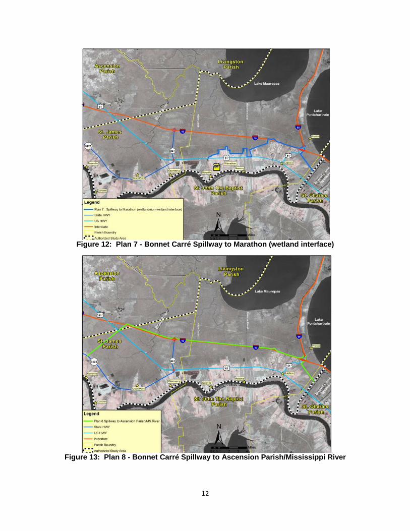
Figure 12: Plan 7 - Bonnet Carré Spillway to Marathon (wetland interface)
Figure 13: Plan 8 - Bonnet Carré Spillway to Ascension Parish/Mississippi River

13
Figure 14: Plan 9 - Bonnet Carré Spillway to Hope Canal/Mississippi River
Figure 15: Plan 10 - Bonnet Carré Spillway to Hope Canal/MS River (I-10 Risk Reduction)
14
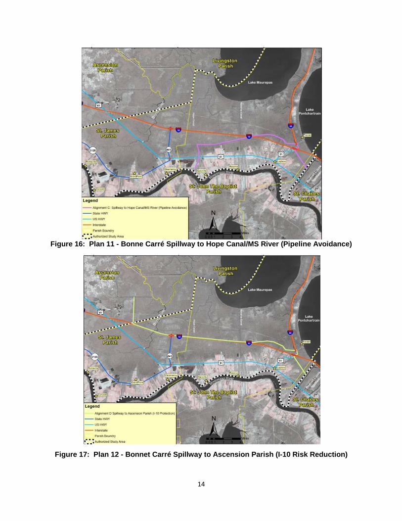
Figure 16: Plan 11 - Bonne Carré Spillway to Hope Canal/MS River (Pipeline Avoidance)
Figure 17: Plan 12 - Bonnet Carré Spillway to Ascension Parish (I-10 Risk Reduction)

15
Discussion on how the alternative plans were ranked and screened can be found in the draft report in Chapter 3 Section 3.4. To determine if plans were viable for further evaluation, plans were scored on how well objectives were met and constraints were avoided (Table 3).
Table 3: Screening and Ranking of Initial Array Plans against Objectives and Constraints
Objectives Ranked (5=High, 4=Medium High , 3=Medium,
2=Medium-Low 1=Low)
Avoids Constraint (5=High, 4=Medium High , 3=Medium, 2=Medium-Low 1=Low)
Condensed Plan ID
#1 Storm damages
#2 Reduce risk to life and health
#5 Reduce the risk of damage and loss of critical infrastructure
#1 Min. impacts to wetlands
#2 Min. impacts to diversion projects
#3 No loss of existing flood protection
#4 Avoid impacts to WMA & wetlands
#5 Min. impacts to critical infrastructure
SUM
Plan 11: Spillway to Hope Canal/MS River (Pipeline Avoidance)
4 4 4 3 3 3 3 5 29
Plan 9: Spillway to Hope Canal/MS River
4 4 4 5 4 1 5 1 28
Plan 10: Spillway to Hope Canal/MS River (I-10 Protection)
4 4 4 2 3 3 2 5 27

16
Objectives Ranked (5=High, 4=Medium High , 3=Medium,
2=Medium-Low 1=Low)
Avoids Constraint (5=High, 4=Medium High , 3=Medium, 2=Medium-Low 1=Low)
Condensed Plan ID
#1 Storm damages
#2 Reduce risk to life and health
#5 Reduce the risk of damage and loss of critical infrastructure
#1 Min. impacts to wetlands
#2 Min. impacts to diversion projects
#3 No loss of existing flood protection
#4 Avoid impacts to WMA & wetlands
#5 Min. impacts to critical infrastructure
SUM
Plan 12: Spillway to Ascension Parish (I-10 Protection)
5 4 5 1 1 4 1 4 25
Plan 8: Spillway to Ascension Parish/MS River
5 4 5 1 1 4 2 4 24
Plan 3: Spillway to ESJ (wetland/non-wetland)
2 1 3 5 4 1 5 2 23
Plan 2: Spillway to East St. John High School (ESJ)
2 1 3 4 4 2 4 2 22
Plan 7: Spillway to Marathon (wetland/non-wetland)
2 2 3 4 4 1 4 1 21
Plan 4: Spillway to ESJ (I-10 Offset)
2 1 3 2 4 2 4 3 21

17
Objectives Ranked (5=High, 4=Medium High , 3=Medium,
2=Medium-Low 1=Low)
Avoids Constraint (5=High, 4=Medium High , 3=Medium, 2=Medium-Low 1=Low)
Condensed Plan ID
#1 Storm damages
#2 Reduce risk to life and health
#5 Reduce the risk of damage and loss of critical infrastructure
#1 Min. impacts to wetlands
#2 Min. impacts to diversion projects
#3 No loss of existing flood protection
#4 Avoid impacts to WMA & wetlands
#5 Min. impacts to critical infrastructure
SUM
Plan 5: Spillway to Marathon
3 2 3 2 4 1 4 1 20
Plan 1: Spillway to Reserve Canal
2 1 3 2 4 2 4 2 20
Plan 6: Spillway to Reserve (US-51 Protection)
2 1 2 4 4 1 4 1 20
After reviewing the aggregate scores, Plans 1 - 6 were eliminated from further consideration because they did not maximize the planning objectives. Plans that could induce flooding to communities outside of the risk reduction system or divided communities were eliminated from consideration because they were considered unacceptable. Descriptions of further analyses and screening are contained in Chapter 3, Sections 3.4 – 3.8.