West Round Mountain Trail West Rd Mtn Trail C B … · park offers over 6.7 miles of hiking trails...
2
Box Canyon Trail A Arizona hiking destination nestled in a pristine desert setting with moderate climate and spectacular views provide ideal hiking conditions. Dedicated on May 13, 1997, the 386 acre park offers over 6.7 miles of hiking trails with scenic vistas, ramadas for picnics, benches to rest your feet, and a visitors center with restroom facilities. The park was originally designed by the UA Landscape Architecture program, and has been upgraded by various service organizations, local businesses, and the City of Globe. Today volunteers work tirelessly to maintain the trails. premier Round Mountain Park is located at the end of South Street from Highway 60. Round Mountain is home to 6 different hiking trails. From beginner to expert, there is something for everyone, from a leisurely walk or jog, to long distance and rocky terrain that will challenge even the most accomplished hikers. Be prepared when hiking in the park, weather conditions could change rapidly. West Round Mountain Trail East Round Mountain Trail Boulder Canyon Trail East Round Mountain Trail starts at the visitor center (point ) and traverses uphill to the top of Round mountain an elevation gain of 380 feet to point . A D West Round Mountain Trail starts at the visitor center (point A) and traverses uphill to the top of Round mountain an elevation gain of 380 feet (point C). Another 0.07 miles to the summit (point D) highest point in the Park elevation 4201. Box Canyon Trail starts at junction of Boulder Canyon Trail (point ), after 0.03 miles Juniper Tree Rest Area (point ) is off to the left. Continuing south another 0.52 miles to the junction of the Ridge Trail (point ). Hiking 0.28 miles will bring you back to the junction of East Trail (point ). K L M F Take East Round Mtn Trail for 0.19 miles to point , veer to the right, the Boulder Canyon Trail extends 0.72 miles to the jct of Box Canyon Trail (point ). Stay left to remain on the Boulder Trail. After 0.23 mi you will reach the junction with the Ridge Trail (point ). Another 0.25 mi you meet Box Canyon trail again (point ), continuing for another 0.27 mi to the Ridge Trail (point ), 0.06 miles to Ridge Trail (point ) and finally 0.19 miles F N O K J G Visitor’s Center Your hike will begin and end at the visitor’s center, with a picnic ramada. Round Mountain Hiking Park Round Mountain Hiking Park Ridge Trail This trail was added to the system in 2010. The trail starts at junction of Boulder Canyon Trail (point ), and loops to the northeast with an optional side loop points & , then heads southwest to the junction of Boulder Canyon Trail (point ), traverses another 0.23 miles to Boulder Canyon Trail (point ) , continues south 0.41 miles to Box Canyon Trail (point ). G H I J O M A B D West Rd Mtn Trail Bulls Eye Rock East Rd Mtn Trail Boulder Canyon Trail Box Canyon Trail Ridge Trail C A F N O K J G E N K L M G M C F E H I J O N N N N N Bull’s Eye Rock Loop Trail A 0.36 mile side hike veer left at point B. Look for the “Bull’s Eye Rock,” a great spot to rest and take a picture. Just a short 0.16 mile walk to the picnic ramada. Prospector’s Trail
Transcript of West Round Mountain Trail West Rd Mtn Trail C B … · park offers over 6.7 miles of hiking trails...
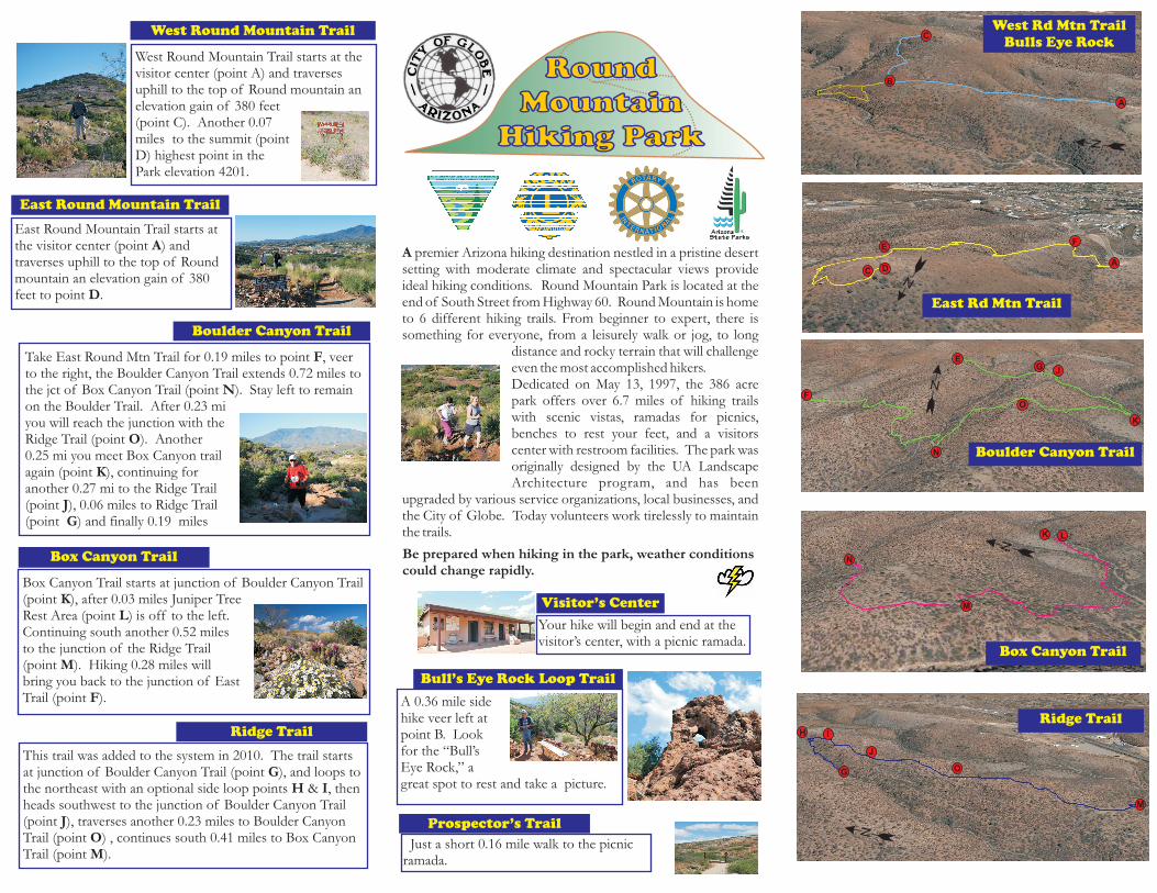
Box Canyon Trail
A Arizona hiking destination nestled in a pristine desertsetting with moderate climate and spectacular views provideideal hiking conditions.
Dedicated on May 13, 1997, the 386 acrepark offers over 6.7 miles of hiking trailswith scenic vistas, ramadas for picnics,benches to rest your feet, and a visitorscenter with restroom facilities. The park wasoriginally designed by the UA LandscapeArchitecture program, and has been
upgraded by various service organizations, local businesses, andthe City of Globe. Today volunteers work tirelessly to maintainthe trails.
premier
Round Mountain Park is located at theend of South Street from Highway 60. Round Mountain is hometo 6 different hiking trails. From beginner to expert, there issomething for everyone, from a leisurely walk or jog, to long
distance and rocky terrain that will challengeeven the most accomplished hikers.
Be prepared when hiking in the park, weather conditionscould change rapidly.
West Round Mountain Trail
East Round Mountain Trail
Boulder Canyon Trail
East Round Mountain Trail starts atthe visitor center (point ) andtraverses uphill to the top of Roundmountain an elevation gain of 380feet to point .
A
D
West Round Mountain Trail starts at thevisitor center (point A) and traversesuphill to the top of Round mountain anelevation gain of 380 feet(point C). Another 0.07miles to the summit (pointD) highest point in thePark elevation 4201.
Box Canyon Trail starts at junction of Boulder Canyon Trail(point ), after 0.03 miles Juniper TreeRest Area (point ) is off to the left.Continuing south another 0.52 milesto the junction of the Ridge Trail(point ). Hiking 0.28 miles willbring you back to the junction of EastTrail (point ).
KL
M
F
Take East Round Mtn Trail for 0.19 miles to point , veerto the right, the Boulder Canyon Trail extends 0.72 miles tothe jct of Box Canyon Trail (point ). Stay left to remainon the Boulder Trail. After 0.23 miyou will reach the junction with theRidge Trail (point ). Another0.25 mi you meet Box Canyon trailagain (point ), continuing foranother 0.27 mi to the Ridge Trail(point ), 0.06 miles to Ridge Trail(point ) and finally 0.19 miles
F
N
O
K
JG
Visitor’s CenterYour hike will begin and end at thevisitor’s center, with a picnic ramada.
RoundMountain
Hiking Park
RoundMountain
Hiking Park
Ridge Trail
This trail was added to the system in 2010. The trail startsat junction of Boulder Canyon Trail (point ), and loops tothe northeast with an optional side loop points & , thenheads southwest to the junction of Boulder Canyon Trail(point ), traverses another 0.23 miles to Boulder CanyonTrail (point ) , continues south 0.41 miles to Box CanyonTrail (point ).
GH I
JOM
A
B
D
West Rd Mtn TrailBulls Eye Rock
East Rd Mtn Trail
Boulder Canyon Trail
Box Canyon Trail
Ridge Trail
C
A
F
N
O
K
JG
E
N
K L
M
G
M
C
FE
H I
J
O
N
N
N
N
N
Bull’s Eye Rock Loop Trail
A 0.36 mile sidehike veer left atpoint B. Lookfor the “Bull’sEye Rock,” agreat spot to rest and take a picture.
Just a short 0.16 mile walk to the picnicramada.
Prospector’s Trail

B
A
F
N
M
H
I
D
C E
G
J
K
O
0.4
6m
i.0.4
6m
i.
0.3
4m
i.
0.2
8m
i.
0.2
2m
i.
N
Ro
un
dM
ou
nta
inP
ark
Hik
ing
Tra
ils
Map
Ro
un
dM
ou
nta
inP
ark
Hik
ing
Tra
ils
Map
Cit
yo
fG
lob
eC
ity
of
Glo
be
Rid
ge
Trail
(1.0
0m
i.)
Rid
ge
Trail
(1.0
0m
i.)
Bu
ll’s
Ey
eR
oc
k(0
.36
mi.
)B
ull’s
Ey
eR
oc
k(0
.36
mi.
)
Bo
xC
an
yo
n(0
.78
mi.
)B
ox
Ca
ny
on
(0.7
8m
i.)
Bo
uld
er
Can
yo
n(1
.47
mi.)
Bo
uld
er
Can
yo
n(1
.47
mi.)
Ea
st
Tra
il(1
.01
mi.
)E
as
tTra
il(1
.01
mi.
)
West
Trail
(0.8
4m
i.)
West
Trail
(0.8
4m
i.)
Tra
ils
5B
en
ch
Nu
mb
er
Ben
ch
Nu
mb
er
Vis
ito
rC
ente
rV
isit
or
Cen
ter
Pro
spec
tor’
sC
anyo
nR
amad
aP
rosp
ecto
r’s
Can
yon
Ram
ada
0.1
7m
i.
0.2
4m
i.
0.0
6m
i.
0.1
9m
i.
0.2
7m
i.
0.2
4m
i.0.2
1m
i.
0.4
9m
i.
P
*T
rail
Desig
n-
Sta
nG
ibson
and
Map
Desig
n-
Ric
hard
L.P
ow
ers
(2010)
Lio
n’s
Clu
bR
amad
aL
ion
’sC
lub
Ram
ada
Su
mm
itR
ou
nd
Mo
un
tain
Su
mm
itR
ou
nd
Mo
un
tain
Rot
ary
Clu
bR
amad
aR
otar
yC
lub
Ram
ada
L
Ju
nip
er
Rid
ge
0.5
1m
i.
0.2
4m
i.
0.0
7m
i.
0.0
3m
i.0.0
3m
i.
0.3
5m
i.
0.4
2m
i.
0.1
9m
i.
0.3
6m
i.
0.0
3m
i.
15
14
13
12
11
10
9 8
3
76
5
4
2
1
16
0.1
6m
i.