WEST LOS ANGELES Community Plancityplanning.lacity.org/complan/pdf/wlacptxt.pdf · provides...
66
WEST LOS ANGELES Co mmun i t y Pl a n TABLE OF CONTENTS ACTIVITY LOG COMMUNI TY MAPS COMMUNI TY PLAN I. Introduction II. Function of the Community Plan III. Land Use Policies and Programs IV. Coordination Opportunities for Public Agencies V. Urban Design Appendix A www.lacity.org/PLN (General Plans) A Part of the General Plan - City of Los Angeles
Transcript of WEST LOS ANGELES Community Plancityplanning.lacity.org/complan/pdf/wlacptxt.pdf · provides...

WEST LOS ANGELES
Community Plan
TABLE OF CONTENTS
ACTIVITY LOG
COMMUNITY MAPS
COMMUNITY PLAN
I. Introduction
II. Function of the Community Plan
III. Land Use Policies and Programs
IV. Coordination Opportunities for Public Agencies
V. Urban Design
Appendix A
www.lacity.org/PLN (General Plans)
A Part of the General Plan - City of Los Angeles

WEST LOS ANGELES
ACTIVITY LOG
ADOPTION DATE
July 27, 1999 Jan. 17, 1997
Nov. 4, 1992 Nov. 17, 1981 Nov. 17, 1981 ADOPTION DATE
Dec. 10, 1997
PLAN
West Los Angeles Community Plan Update West Los Angeles Transportation Improvement
Mitigation Program Specific Plan Sepulveda Corridor Specific Plan Century City North Specific Plan Century City South Specific Plan
AMENDMENT
Westwood/Pico Neighborhood Overlay District
CPC F LE NO.
97-0048 CPU 96-0220 SP
91-0488 SP 28436 ZC/HD 24960 CPC F LE NO.
92-0039 SUD
92-0041 HD 92-0042 ZC
COUNCIL ILE NO.
98-2024 96-0156
91-2205; 92-0885 80-1250 S1 74-4757
COUNCIL ILE
92-1785
I F
I F
Sept. 7, 2016 Mobility Plan 2035 Update CPC-2013-910-GPA-SPCA-MSC 15-0719

WEST LOS ANGELES
Community Plan
Chapter I
INTRODUCTION
COMMUNITY BACKGROUND
PLAN AREA The West Los Angeles Community Plan area is located in the western portion
of the City of Los Angeles. It is generally bounded by Centinela Avenue on
the west, Wilshire Boulevard and Santa Monica Boulevard on the north,
National Boulevard, Pico Boulevard, and Exposition Boulevard on the south,
and Durango Avenue, Robertson Boulevard, and Canfield Avenue on the east.
It is surrounded by the communities of Westwood, Brentwood-Pacific
Palisades, Palms - Mar Vista - Del Rey, West Adams-Baldwin Hills-Leimert,
and Wilshire; and by the Cities of Culver City, Santa Monica, and Beverly
Hills, and the County of Los Angeles.
The majority of the Community Plan area consists of low rolling hills and flat
plains, and contains approximately 4,565 acres, which is 1.74 percent of
the land in the City of Los Angeles.
Low Density, single-family development comprises a majority of the
residential land use in the Community. A mix of multiple-family development
includes apartments and condominiums at varying densities and building
types (duplexes, small, medium and large complexes and some high rise
structures).
Commercial land use consists primarily of strip development on major
arterials such as Wilshire, Santa Monica, Pico, Sawtelle, and Westwood
Boulevards. The majority of commercial facilities are either small-scale and
free standing or mini-mall type buildings designed to primarily serve local
neighborhoods.
The Century City Shopping Center and the Westside Pavilion are major
shopping centers that attract customers from West Los Angeles and
neighboring communities. The former is part of a Regional Center that also
contains high rise office buildings, a major entertainment center and two large
hotels.
Most of the community’s industrial land use is located between Sepulveda
Boulevard and Cotner Avenue, and west of Sepulveda Boulevard in the vicinity
of Olympic, Exposition and Pico Boulevards. This development provides an
employment base consisting of small, medium and large manufacturing
businesses, wholesale / retail distribution outlets, and storage operations.
WEST LOS ANGELES
I-1

A civic center providing governmental functions is located in the vicinity of
Santa Monica Boulevard west of the San Diego (405) Freeway. This center
provides administrative and community services for the greater West Los
Angeles area and includes a County Courts building, library, post office,
police station, and senior center.
There are several specific plans regulating land use development in the
community. These include: (1) Century City North Specific Plan for the
retail, office, and entertainment functions in Century City, (2) Century City
South Specific Plan for multi-family homes, office tower, hotel and Fox
Studios, and (3) West Los Angeles Transportation Improvement and
Mitigation Specific plan, and (4) Sepulveda Corridor Specific Plan in the
industrially designated area. COMMUNITY
PARTICIPATION The State of California requires citizen participation in the preparation of the
General Plan. Government Code Section 65351 reads “During the preparation
or amendment of the General Plan, the planning agency shall provide
opportunities for involvement of citizens, public agencies, public utility
companies, and civic, education, and other community groups, through public
hearings and any other means the city or county deems appropriate”.
Community participation occurred through focus group meetings, a public
workshop, an open house and a public hearing. Community members
assisted in identifying major issues and formulating the land use policies and
objectives contained in the West Los Angeles Community Plan.
COMMUNITY ISSUES AND OPPORTUNITIES
The following summarizes the most significant planning and land use issues
and opportunities which were identified in the West Los Angeles Community. RESIDENTIAL Issues
C Need to maintain the low density character of single family
neighborhoods and avoid encroachment from other uses, commercial
off-street parking, or spillover traffic.
C Preservation of residential neighborhoods and provision of more affordable
housing and child care facilities.
C Lack of transition in scale, density and character between multiple
housing and adjacent single family neighborhoods.
C Inadequate transition between commercial and industrial uses and single
and multi-family areas.
C Lack of adequate parking, usable open space and recreational facilities
in multiple-family housing.
C Non-conforming residential units in areas zoned and designated for
industrial land use.
WEST LOS ANGELES
I-2

C Need to coordinate new development with the availability of public
infrastructure.
Opportunities
C A diverse community that is socially and economically vibrant with
unique architectural and historic characteristics, and having a mild
climate with ocean breezes.
C Proximity to cultural and intellectual resources such as museums,
theaters and educational institutions, as well as recreational and ocean
amenities, and the Los Angeles (LAX) and Santa Monica airports.
C Access to major freeways and proximity to employment centers in
downtown Los Angeles and Century City.
C Potential for mixed-use development along Santa Monica, Wilshire, and
Sawtelle Boulevards, major commercial corridors. COMMERCIAL Issues
C Lack of cohesiveness and continuity of complementary uses along
commercial frontages.
C Unsightly strip commercial development with poor visual identity, lack
of parking and convenient access and oriented to automobile traffic rather
than neighborhood pedestrian use.
C Proliferation of out-of-scale signs including billboards, wall signs, and
flashing signs.
C Unsightliness of some new construction due to a lack of landscaping,
and unimaginative architectural quality.
C New commercial development incompatible with existing buildings in
terms of architectural design, bulk and building heights.
C Lack of street scape improvements including street furniture and street
trees to create a more pedestrian and neighborhood friendly environment.
Opportunities
C Existing Specific Plans for Century City South and North that regulate
land uses by vehicle trip generation, and provide traffic mitigation.
C Proposed Santa Monica Boulevard improvements to enhance the visual
environment, and foster pedestrian activities.
C Through the Westwood - Pico Neighborhood Overlay District,
establishment of appropriate neighborhood and pedestrian-oriented land
uses, building intensity, lot coverage, setbacks, landscaping, signage
controls, design and parking requirements for Westwood Boulevard and
Pico Boulevard in the vicinity of the Westside Pavilion.
WEST LOS ANGELES
I-3

C Potential for mixed-use on Santa Monica, Wilshire, and Sawtelle
Boulevards to encourage pedestrian activity, reduce traffic circulation
and congestion, invigorate commercial areas and increase their viability.
C A shuttle bus system to connect major activity centers (Century City,
Westside Pavilion, West Los Angeles Civic Center, V.A. Hospital,
Federal Building, UCLA).
C Preservation of existing neighborhood commercial uses (general goods
stores, ethnic restaurants, plant nurseries, resident hotels, etc.) along
Sawtelle Boulevard between Olympic Boulevard and Ohio Avenue. INDUSTRIAL Issues
C Utilization of industrially designated land for commercial and retail
purposes.
C Inadequate buffering and landscaping in industrial areas where residential
development is located, especially south of Exposition Boulevard.
C Non-conforming residential units in the area zoned and designated for
industrial land use.
C Aesthetic improvement of industrially-designated major arteries (e.g.,
along Sepulveda Boulevard).
Opportunities
C Preservation of all land presently zoned and designated for industrial use
to provide an employment base.
C Development of standards and Plan policies to visually improve industrial
areas.
C Encouragement of entertainment or advanced technology uses in the
industrially designated areas. TRANSPORTATION Issues
C Severe traffic congestion along major transportation corridors and
intersections with most streets functioning at full capacity.
C Inadequate transportation linkages between residential areas and
commercial, retail and recreation facilities.
C Inadequate transit feeder services from residential neighborhoods to
major transportation corridors and activity centers.
C Inadequate automobile alternatives such as rail, bus service and streets
or paths which encourage biking and walking.
C Spillover parking from commercial areas into residential areas.
WEST LOS ANGELES
I-4

Opportunities
C West Los Angeles Transportation Improvement and Mitigation Specific
Plan (TIMP) which mitigates the impact of new development on the
circulation system primarily through transportation impact fees and
project phasing.
C Street improvement of Santa Monica Boulevard being undertaken by the
Metropolitan Transportation Authority and the City of Los Angeles to
improve traffic flow, reduce congestion, and enhance the appearance of
the street.
C Improved and expanded bicycle lanes coordinated with systems in
adjacent communities to provide convenient access to major activity
centers, community schools and recreation areas.
C Expansion of alternative transportation strategies such as Automated
Traffic Surveillance and Control (ATSAC) on all major traffic corridors.
C Implementation of traffic mitigation measures required for major projects
in the area.
C Busway/bikeway corridor along the abandoned railroad right-of-way south
of Exposition Boulevard. RECREATION AND Issues
PUBLIC FACILITIES C
Location of public facilities and parks with respect to a perceived negative
impact on residential neighborhoods.
C Provision of additional facilities such as parks, libraries and community
centers.
Opportunities
C Construction of libraries, community centers or day care facilities as a
development incentive in large mixed-use projects.
C Continued dual utilization of school facilities for public
recreational/educational purposes. MAJOR
OPPORTUNITY SITES There are no large, vacant parcels in the community. Many changes are
likely to occur from modifications or adaptive reuse of buildings. Due to the
existing level of traffic congestion, the impact of new large projects on traffic
circulation will continue to be a major concern in the community.
A large public works project with a potential positive impact on the community
is the Santa Monica Boulevard Transit Parkway project being undertaken by
the Metropolitan Transportation Authority (MTA) and the City of Los Angeles.
The abandoned railroad right-of-way located south of Exposition Boulevard
should be considered for a busway and/or bikeway corridor. Neighborhood
park or open space use with a bikeway could also be considered as an
alternative possibility. WEST LOS ANGELES
I-5

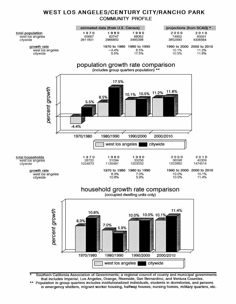
COMMUNITY PROFILE
The Community Profile provides an overview of population, housing, and
socio/demographics for the West Los Angeles Community Plan Area and
compares it to the rest of the City. The following tables contain the statistical
data for previous census dates and rates of growth.
WEST LOS ANGELES
I-6


Chapter II
FUNCTION OF THE COMMUNITY PLAN
STATUTORY REQUIREMENTS
California State law (Government Code Section 65300) and the City of Los
Angeles City Charter (Section 96.5) require that the City prepare and adopt
a comprehensive, long term General Plan for its development. It must contain
seven mandatory elements including land use, circulation, housing,
conservation, open space, noise and safety. California State law requires
that the land use element be prepared as part of a City’s General Plan and
that it correlate with the Circulation Element. In the City of Los Angeles,
thirty-five community plans comprise the City’s Land Use Element.
The Land Use Element has the broadest scope of the State required General
Plan elements, since it regulates how land is to be utilized. It correlates with
many of the issues and policies contained in all other plan elements.
Government Code Section 65302(a) requires a land use element which
designates the proposed general distribution and general location and extent
of the following land uses: housing, business, industry, open space,
agriculture, natural resources, recreation and enjoyment of scenic beauty,
education, public buildings and grounds, solid waste disposal facilities and
other categories of public and private land uses. The Land Use Element is
also required to include a statement of the standards of population density
and building intensity recommended for the various communities and other
territory covered by the Plan.
The West Los Angeles Community Plan is a part of the General Plan of the
City of Los Angeles. It consists of this text and the accompanying map.
The Community Plan text states the goals, objectives, policies, and
programs. The Community Plan map outlines an arrangement and intensity
of land uses, the street system and the locations and characteristics of public
service facilities.
ROLE OF THE COMMUNITY PLAN
The General Plan is the fundamental policy document of the City of Los
Angeles. It defines the framework by which the City’s physical and economic
resources are to be managed and utilized over time. The Plan guides the
City in the use of its land, design and character of buildings and open
spaces, conservation of existing and provision of new housing, provision of
supporting infrastructure and public services, protection of environmental
resources and protection of residents from natural and other known hazards.
The Community Plans are intended to promote an arrangement of land uses,
streets and services which will encourage and contribute to the economic,
social and physical health, safety, welfare and convenience of the people who
live and work in the community. The Plans also guide development by
WEST LOS ANGELES
II-1

informing the general public of the City’s goals, policies and development
standards with the objective of creating a healthy and pleasant environment.
Goals, objectives, policies and programs are created to meet the existing
and future needs of the community through the year 2010. The Plans are
intended to coordinate development among the various parts of the City of
Los Angeles and adjacent municipalities which benefit all residents.
The General Plan expresses the City’s intentions with respect to the rights
and expectations of the general public, property owners, and prospective
investors and business interests. Through the Community Plan, the City can
inform these groups of its goals, policies and development standards, thereby
communicating what is expected of the City government and private sector
to meet its objectives.
The Community Plan allocates sufficient land in the community for housing,
commercial, employment, educational, recreational, cultural and social uses.
The Plan identifies and provides for the maintenance of any significant
environmental resources within the community. It also seeks to enhance
the distinctive community identity and recognizes its unique neighborhoods
within the Plan Area.
PURPOSE OF THE COMMUNITY PLAN
The last comprehensive review of the West Los Angeles Community Plan
was completed in 1974, and revised in 1988 through the General Plan
Consistency Program and through on-going Periodic Plan Review and other
Plan amendments. Since that time, considerable growth has occurred, new
issues have emerged, and new community objectives regarding the
management of new development and community preservation have evolved.
Consequently, it became necessary to update the Community Plan to not
only reflect current conditions, but to accurately reflect the prevailing visions
and objectives of the area’s residents and property and business owners.
The Community Plan sets forth goals and objectives to maintain the
community's distinctive character by:
C Preserving and enhancing the positive characteristics of existing
residential neighborhoods while providing a variety of compatible housing
opportunities.
C Improving the function, design and economic vitality of commercial and
industrial areas.
C Preserving and enhancing the positive characteristics of existing uses
which provide the foundation for community identity, such as scale,
height, bulk, setbacks and appearance.
C Maximizing development opportunities around future transit systems
while minimizing any adverse impacts.
C Preserving and strengthening commercial and industrial developments
to provide a diverse job-producing economic base; and through design
WEST LOS ANGELES
II-2

guidelines and physical improvements, enhance the appearance of these
areas.
ORGANIZATION AND CONTENT OF THE COMMUNITY PLAN
This Plan sets forth goals, objectives, policies, and programs that pertain to
the West Los Angeles Community. Broader issues, goals, objectives and
policies are provided by the Citywide General Plan Framework Element.
The Plan is organized and formatted to facilitate periodic updates. The State
recommends that a plan be comprehensively reviewed every five years to
reflect new conditions, local attitudes and technological advances.
The principal method for the implementation of the Land Use Map is the
Zoning Ordinance. The City’s Zoning Map must be updated to remain
consistent with the adopted Land Use Map. Together, the Zoning Ordinance
and the Zoning Map identify specific types of land use and development
standards applicable to specific areas and parcels of land within a
community.
RELATIONSHIP TO OTHER GENERAL PLAN ELEMENTS
The Community Plan includes appropriate policies and implementation
measures generated from the mitigation measures listed in the environmental
clearance. In many instances these measures encompass the policies
contained in the General Plan Framework.
The City of Los Angeles is responsible for revising and implementing its’
General Plan. State law requires that the General Plan have internal
consistency. The West Los Angeles Community Plan, which is a portion
of the City’s Land Use Element must be consistent with other elements and
components of the General Plan.
The General Plan Framework Element is a long range, citywide,
comprehensive growth strategy. It is a special element of the General Plan
which plans for the future as required by law and replaces Concept Los
Angeles and the Citywide Plan (adopted in 1974). Therefore, the Framework
Element looks at the City as a whole and provides a citywide context within
which local planning takes place. It discusses both the benefits and
challenges of growth.
Because it takes citywide perspective, the Framework Element cannot
anticipate every detail. The Community Plans must be looked to for final
determinations as to the boundaries, land use categories, intensities and
heights that fall within the ranges described by the Framework Element. The
Framework Element neither overrides nor supersedes the Community Plans.
It guides the city’s long range growth and development policy, establishing
citywide standards, goals, policies and objectives for citywide elements and
community plans. The Framework Element is flexible, suggesting a range
of uses within its land use definitions. Precise determinations are made in
the Community Plans.
WEST LOS ANGELES
II-3

The General Plan Framework Element projects the following population,
housing and employment levels for the West Los Angeles plan area for the
year 2010:
Population (persons):
Housing (units):
Employment (jobs):
83,331
42,877
110,479
These numbers are provided as reference during the Community Plan Update
and are best estimates that are derived from regional data which are
disaggregated to the City and then to the community level. Population,
employment and housing could grow more quickly or slowly than anticipated
depending on economic trends.
Regional forecasts do not generally reflect the the adopted Community Plan
land use capacity or build out estimate from planned land use. Plan capacity
or build out is also an imprecise estimate and depends on specific
assumptions about future development density and household size, which
may vary from what actually occurs. Community Plan capacity does not
include housing located within commercial districts nor the current residential
vacancy rate.
In addition to the seven State mandated elements, the City’s General Plan
includes a Service System Element, a Cultural Element, a Major Public
Facilities Element and an Air Quality Element. All the provisions and
requirements of these elements apply to the West Los Angeles Community
Plan.
There are also other types of plans such as specific plans or neighborhood
plans which set detailed policy and development regulations for unique
neighborhoods within a community. In addition to these, there are overlay
zones which combine policy and implementation functions to address issues
specific to a neighborhood.
PLAN CONSISTENCY
Each land use category within a Community Plan indicates the corresponding
zones permitted unless it is restricted by the Plan text, footnotes, adopted
specific plans or other limitations established by discretionary approvals.
The residential densities, commercial and industrial intensities depicted on
the Plan map are theoretical and will not occur due to Plan and zone
restrictions, economic conditions and design limitations.
The Plan permits all corresponding zones designated with each Plan
category and also zones which are more restrictive, as referenced in Section
12.23 of the Los Angeles Municipal Code (LAMC). Any subsequent action
or monitoring review that modifies the Plan must make new plan consistency
findings as part of that decision.
City actions on most discretionary approval projects require a finding that
the action is consistent or in conformance with the General Plan.
Discretionary approval projects in the West Los Angeles Community Plan
area will require the decision maker to refer to additional programs, policies
or objectives in Chapter III of the Plan. To further substantiate the
WEST LOS ANGELES
II-4

consistency findings, decision makers may cite other programs, policies or
objectives which would be furthered by the proposed project.
PLAN MONITORING The Plan has a land use capacity greater than the projected development
likely to occur during the Plan period. During the life of the Plan, growth will
be monitored and reported in the City’s Annual Report on Growth and
Infrastructure, which will be submitted to the City Planning Commission,
Mayor and City Council. In the fifth year following Plan adoption (and every
five years thereafter), the Director of Planning shall report to the Commission
on the relationship between population, employment, housing growth and plan
capacities. If growth has occurred faster than projected, a revised
environmental analysis will be prepared and appropriate changes
recommended to the Community Plan and zoning. These Plan and zoning
changes and any related moratoria or interim control ordinances, shall be
submitted to the Planning Commission, Mayor and City Council as specified
in the Los Angeles Municipal Code.
WEST LOS ANGELES
II-5

Chapter III
LAND USE POLICIES AND PROGRAMS
Chapter III of the Plan text contains goals, objectives, policies, and programs
for appropriate land use issues of residential, commercial, and industrial,
public and institutional service system categories. The Planning Department
has authority for the goals, objectives, policies, the initiation and direct
implementation of the programs contained in Chapter III.
RESIDENTIAL
The quality of life and stability of neighborhoods throughout the West Los
Angeles Community critically depends on providing infrastructure resources
(i.e., police, fire, water, sewerage, parks, traffic circulation, etc.)
commensurate with the needs of its population. If population growth occurs
faster than projected and without needed infrastructure improvements to keep
pace with that growth, the consequences for livability within the Community
could be problematic.
Accordingly, the proposed Plan has three fundamental premises. First, is
limiting residential densities in various neighborhoods to the prevailing density
of development in these neighborhoods. Second, is the monitoring of
population growth and infrastructure improvements through the City’s Annual
Report on Growth and Infrastructure with a report to the City Planning
Commission every five years on the West Los Angeles Community following
Plan adoption. Third, if this monitoring finds that population in the Plan area
is occurring faster than projected; and, that infrastructure resource capacities
are threatened, particularly critical ones such as water and sewerage; and,
that there is not a clear commitment to at least begin the necessary
improvements within twelve months; then building controls should be put into
effect, for all or portions of the West Los Angeles Community, until land use
designations for the Community Plan and corresponding zoning are revised
to limit development.
The Community Plan includes appropriate policies and implementation
measures generated from the mitigation measures listed in the environmental
clearance. In many instances these measures encompass the policies
contained in the General Plan Framework Element.
According to the 1990 Census, the Community Plan area had a population
of 68,062. This included an ethnic mix of 73.1 percent Caucasian (non-
Hispanic), 12.8 percent Hispanic, 11.2 percent Asian, 2.6 percent African
American, and less than one percent Native American.
The 1990 Census indicated that there were 35,679 total dwelling units in the
Community. Of this total, 10,089 (28 percent) were single-family units, and
25,590 (72 percent) were multi-family units. Most of the housing is well
maintained. Some older units have been replaced with new construction that
provides landscaped front yards, in-house amenities, and subterranean
parking for multiple residential developments
The Community Plan designates 2,161 acres of residential land use, or 47
percent of the Plan area. Residential land use in the Plan consists of 1,472
WEST LOS ANGELES
III-1

acres of Low Density Residential representing 68 percent of the total
residential land use, and 141 acres of Low Medium Density, or seven percent.
The remaining 548 acres is 25 percent of the total, consisting of Medium and
High Medium Density Residential.
The following table depicts the reasonable expected population and dwelling
unit count for the year 2010, using a mid-point range for the dwelling units
per acre category. The mid-point represents a reasonable factor, since new
development within each land use category is unlikely to occur at the
extremes of the range, but more likely, throughout the range.
PLAN POPULATION AND DWELLING UNIT CAPACITY
Residential
Land Use
Category Low Low Medium I Low Medium II Medium High Medium
Dwelling Units
Per Net Acre Midpoint (Range)
6.5 (4+ -- 9)
13.5 (9+ -- 18)
23.5 (18+ -- 29)
42.0 (29+ -- 55) 82.0 (55+ -- 109)
Number of
Dwelling
Units
9,568
1,296
1,058
19,530
6,806
Net Acres
1,472
96
45
465
83
Persons Per
Dwelling Unit
(2010)
2.64
1.89
1.89
1.85
1.87
Reasonable
Exp. Population
(2010)
25,260
2,449
2,000
36,130
12,727 TOTALS 38,258 2,161 78,566
GOAL 1
Objective 1-1
A SAFE, SECURE, AND HIGH QUALITY RESIDENTIAL ENVIRONMENT
FOR ALL ECONOMIC, AGE, AND ETHNIC SEGMENTS OF THE
COMMUNITY. To provide for the preservation of existing housing and for the development
of new housing to meet the diverse economic and physical needs of the
existing residents and projected population of the Plan area to the year 2010.
Policies
1-1.1 Protect existing single family residential neighborhoods from new
out-of scale development and other incompatible uses.
Program: The Plan map identifies lands where only single family
development is permitted. These areas are protected by designating
appropriate densities for each land use category and corresponding
zone designations directed at minimizing incompatible uses.
1-1.2 Promote neighborhood preservation in all residential neighborhoods.
Program: With the implementation of the Community Plan, all
discretionary actions, specific plans, community and neighborhood
residential projects are to be consistent with Plan recommendations.
WEST LOS ANGELES
III-2
Program: In discretionary project approval, the decision-maker
should not approve densities in excess of those in adjacent or
surrounding neighborhoods.
Program: Make funds available through the Neighborhood
Preservation Program administered by the City’s Housing
Department to rehabilitate single family homes and multi-family
housing.
Program: Provide loans to owners of small residential buildings
(one to four units) to correct code violations through the Homeowners
Encouragement Loan Program (HELP), administered by the City’s
Housing Department.
1-1.3 Provide for adequate multi-family residential development.
Program: The Plan Map identifies specific areas where multi-family
residential development is permitted. Objective 1-2 To reduce vehicular trips and congestion by developing new housing in
proximity to adequate services and facilities.
Policies
1-2.1 Locate higher residential densities near commercial centers and
major bus routes where public service facilities and infrastructure will
support this development.
Program: The plan designates most of the higher residential
densities near major transit corridors, and in the Century City
regional center.
1-2.2 Locate senior citizen housing within reasonable walking distance
of health and community facilities, services and public transportation.
Program: The Plan identifies these areas by designating higher
density at such locations.
1-2.3 Do not increase residential densities beyond those permitted in the
Plan unless the necessary infrastructure and transportation systems
are available to accommodate the increase.
Program: The decision maker should adopt a finding which
addresses the availability and adequacy of infrastructure as part of
any decision relating to an increase in permitted residential density. Objective 1-3 To preserve and enhance the varied and distinct residential character and
integrity of existing residential neighborhoods.
Policies
1-3.1 Require architectural compatibility and adequate landscaping for new
multi-family residential development to protect the character and
scale of existing residential neighborhoods.
WEST LOS ANGELES
III-3

Program: The Plan includes Design Guidelines for multi-family
residential development.
1-3.2 Proposals for change to planned residential density should consider
factors of neighborhood character and identity, compatibility of land
uses, impacts on livability, public services and facilities, and traffic
levels.
Program: A decision-maker should not approve a project that
exceeds the average density of the existing neighborhood unless
findings can be made that the area will not be adversely affected. Objective 1-4 To promote adequate and affordable housing and increase its accessibility
to more segments of the population, especially students and senior citizens.
Policies
1-4.1 Promote greater individual choice in type, quality, price and location
of housing.
Program: The Plan promotes greater individual choice by allocating
adequate lands in the Plan for a variety of residential densities, and
the promotion of housing in mixed-use projects.
1.4-2 Ensure that new housing opportunities minimize displacement of
residents.
Program: A decision-maker should adopt a finding which addresses
this factor in any decision relating to the construction of new
housing.
1.4-3 Encourage multiple residential development in specified commercial
zones.
Program: The Plan identifies areas for mixed use development in
commercial zones.
COMMERCIAL In 1990, West Los Angeles contained approximately 23.3 million square feet
of commercial development. Approximately 17.6 million square feet (76
percent) was devoted to office use, and 5.7 million (24 percent) to retail use.
Commercial land use designated in the West Los Angeles Community Plan
consists of 314 acres, or seven (7) percent of the total acreage. Most of the
commercial development can be categorized within four concentrations based
on the general orientation of uses: Regional, Community, General and
Neighborhood. REGIONAL
COMMERCIAL The area designated in the Plan as Regional Commercial is the Century City
complex. It is approximately 99 acres in size and is generally bounded by
Santa Monica Boulevard, Century Park West, the City of Beverly Hills, and
Olympic Boulevard. It is primarily improved with high rise office buildings,
two large hotels, an entertainment center and a regional shopping complex.
It is designated in the General Plan Framework Element and on the Community Plan Land Use Diagram as a Regional Center. The area
WEST LOS ANGELES
III-4

comprises the Century City North Specific Plan and the Century City South
Specific Plan area except for Fox Studio site, and is subject to development
restrictions based on trip generation. COMMUNITY
COMMERCIAL There are several areas designated as Community Commercial that total
approximately 24 acres. These include the south side of Wilshire Boulevard
between Bundy Drive and Granville Avenue, Sepulveda Boulevard north of
National Boulevard, and the south side of Pico Boulevard between Overland
Avenue and Veteran Avenue. These areas have been developed with
commercial land uses ranging from one and two story retail to high-rise
office, and a large shopping center (Westside Pavilion). Wilshire Boulevard
between Wellesley Avenue and Granville Avenue is designated as a Mixed
Use Boulevard on the Community Plan Land Use Diagram. The majority of
this segment is shown as Community Commercial on the Plan Map. NEIGHBORHOOD Approximately 127 acres are designated as Neighborhood Commercial,
COMMERCIAL located along portions of Santa Monica, Sawtelle, Westwood, Pico, and
National Boulevards. These areas are primarily developed with one to four story retail and office uses, with a mix of residential units along Sawtelle
Boulevard. The latter is identified as a Mixed Use Boulevard on the
Community Plan Land Use Diagram. The frontage along Westwood
Boulevard north to Missouri Avenue, and Pico Boulevard generally between
Patricia Avenue and Military Avenue, (excluding the Westside Pavilion) is
designated as a Neighborhood District on the Community Plan Land Use
Diagram. This is consistent with the Westwood-Pico Neighborhood Overlay
District (Ordinance No. 171,859) which is intended to foster a pedestrian
friendly street scape in the area. GENERAL
COMMERCIAL The remaining commercial areas designated as General Commercial consist
of approximately 64 acres and are located on portions of Wilshire, Santa
Monica, Pico and National Boulevards. The south side of Wilshire Boulevard
has been developed with high rise office buildings and one to three story retail
and office buildings. Land uses on Pico and National Boulevards include one
to three story retail buildings. The south side of Santa Monica Boulevard is predominantly improved with retail and office uses, but also supports several
older low-density apartment buildings, motels and auto-oriented
establishments. It is identified as a Mixed Use Boulevard on the Community
Plan Land Use Diagram.
The portion of Santa Monica Boulevard between the Beverly Hills City limit
and the San Diego Freeway which is part of California State Route 2 is
currently part of a Transit Parkway Study being conducted by the Los
Angeles Metropolitan Transportation Authority (MTA). The main focus of
this study is to improve the regional traffic flow, reduce congestion and
enhance safety, while beautifying the Boulevard with landscaping and
preserving the character of adjacent neighborhoods. MIXED USE The Mixed Use Boulevard concept would engender cohesive commercial
development that could be integrated with housing in a typically vertical
pattern. These structures would normally incorporate retail, office and/or
parking on the lower floor and residential units on the upper floors. The mixed
WEST LOS ANGELES
III-5

use concept could also accommodate separate commercial and residential
structures in the same block. The intent of mixed use development is to
provide housing in proximity to jobs and services, to reduce vehicular trips,
congestion and air pollution, to provide for rental housing, and to stimulate
pedestrian-oriented areas. Mixed use development may also provide
community facilities such as libraries, meeting rooms, post offices, senior
centers, or day care facilities for children.
While the Plan does not mandate mixed-use projects, it encourages them
in commercially designated areas which have the potential for such uses. GOAL 2 A STRONG AND COMPETITIVE COMMERCIAL SECTOR WHICH
PROMOTES ECONOMIC VITALITY, SERVES THE NEEDS OF THE
COMMUNITY THROUGH WELL DESIGNED, SAFE AND ACCESSIBLE
AREAS WHILE PRESERVING HISTORIC AND CULTURAL CHARACTER. Objective 2-1 To conserve and strengthen viable commercial development and to provide
additional opportunities for new commercial development and services within
existing commercial areas.
Policies
2-1.1 New commercial uses shall be located in existing established
commercial areas or shopping centers.
Program: The Plan map designates appropriate locations where
commercial uses are permitted.
2-1.2 Protect commercially planned/zoned areas from encroachment by
residential only development.
Program: Provisions of the Zoning Code currently restrict floor area
of buildings including residential buildings, in most commercial
zones with Height District No. 1, to one and one-half the floor area.
This provision effectively discourages residential only developments
in commercial zones. It is recommended that future requests to
change commercial zones to residential zoning not be given
favorable consideration by decision makers.
2-1.3 Ensure the viability of existing neighborhood stores and businesses
which support the needs of local residents and are compatible with
the neighborhood.
Program: Assist businesses in obtaining technical assistance for
Business Improvement Districts (BID) and other programs from the
City of Los Angeles. Objective 2-2 To promote distinctive commercial districts and pedestrian-oriented areas.
Policies
2-2.1 Encourage Pedestrian-oriented design in designated areas and in
new development.
WEST LOS ANGELES
III-6

Program: Implement design policies in designated areas to ensure
the creation of pedestrian friendly commercial development.
Program: A Neighborhood Overlay District has been established
along Westwood and Pico Boulevards in the area designated as a
Neighborhood District on the Community Plan Land Use Diagram,
which includes applicable design standards.
2-2.2 Promote mixed-use projects along transit corridors and in
appropriate commercial areas.
Program: The Community Plan Land Use Diagram identifies
portions of Santa Monica, Wilshire and Sawtelle Boulevards as
Mixed Use Boulevards. Properties along designated Mixed Use
Boulevards are limited to a Floor Area Ratio (FAR) of 1.5 to 1, and
the maximum building height permitted by the existing zoning.
2-2.3 Require that mixed use projects and development in pedestrian
oriented districts be designated and developed to achieve a high level
of quality, distinctive character, and compatibility with existing uses.
Program: The Plan includes Design Guidelines which implement
this policy for commercial projects and projects located within
pedestrian oriented districts.
2-2.4 Encourage large mixed use projects to incorporate facilities
beneficial to the community such as libraries, child care facilities,
community meeting rooms, senior centers, police sub-station, and/or
other appropriate human service facilities as part of the project.
Program: Additional floor area beyond 1.5:1 or additional height
could be permitted within Mixed Use Boulevards, if facilities
beneficial to the community are provided.
Program: One incentive might be to allow residential land use in
commercially zoned areas only on those streets designated in the
Plan as Mixed Use Boulevard and not in other commercially-zoned
and designated areas. Such implementing methods would
necessitate separate ordinances enacted through enabling
legislation.
2-2.5 Require that the first floor street frontage of structures, including
mixed use projects and parking structures located in pedestrian
oriented districts, incorporate commercial uses.
Program: The decision maker should incorporate such
requirements in discretionary actions. Objective 2-3 To enhance the appearance of commercial districts.
Policies
2-3.1 Establish street identity and character through appropriate sign
control, landscaping and streetscape improvements; and require that
WEST LOS ANGELES
III-7

new development be compatible with the scale of adjacent
neighborhoods.
Program: Provide for a funding mechanism that would buy out
existing billboards along Santa Monica Boulevard (and throughout
the community); and, prohibit future billboards by special ordinance.
(The MTA presently owns the Santa Monica Boulevard median which
is planned to be relinquished to the City as part of the Transit
Parkway Study. The MTA anticipates removal of billboards in the
median due to project construction with provision of compensation
to advertisers).
Program: The design standards in the Plan are intended to serve
as a reference for other City Departments, public agencies and the
private sector regarding improvement of public spaces and rights-of-
way.
Program: Assistance from the City of Los Angeles in the creation
and implementation of Business Improvement Districts.
Program: Implement design policies and standards contained in
the Plan when the decision maker approves discretionary projects.
2-3.2 Require that commercial projects be designed and developed to
achieve a high level of quality, distinctive character and compatibility
with surrounding uses and development.
Program: The Plan contains Design Guidelines for commercial
development.
Program: Community Design Overlay Districts could be considered
in commercially zoned and designated areas.
INDUSTRIAL The West Los Angeles area maintains a strong industrial base. In 1990, there
were approximately 5.6 million square feet of industrial development in the
Community, representing 1.8 percent of the total industrial square footage in the City of Los Angeles.
A total of 283 acres, or six percent of the Community’s total area is
designated in the Plan for industrial use. This area is generally located
between Cotner Avenue and Sepulveda Boulevard, and in the vicinity of
Exposition Boulevard and Olympic Boulevard, west of Sepulveda Boulevard.
The Fox Studio site is also designated as industrial land use in the Plan.
Some of these areas have been developed with two to four story retail and
medium to high-rise office buildings (four to 15 stories); however, the majority
of the area has been developed with retail / wholesale businesses and
manufacturing uses. GOAL 3 SUFFICIENT LAND FOR A VARIETY OF INDUSTRIAL USES WITH MUM
EMPLOYMENT OPPORTUNITIES THAT ARE SAFE FOR THE
ENVIRONMENT AND THE WORKERS, AND WHICH HAVE MINIMAL
ADVERSE IMPACT ON ADJACENT USES.
WEST LOS ANGELES
III-8

Objective 3-1 To retain existing industrial uses and promote future development which
contributes to job opportunities and minimizes environmental impacts.
Policies
3-1.1 Designate and preserve lands for the continuation of existing industry
and development of new industrial parks, research and development
uses, light manufacturing and similar uses.
Program: Adequate industrial land is designated on the Plan map
to accommodate a variety of industrial uses. The Century City South
Specific Plan regulates land primarily for use in studio operations.
3-1.2 Ensure compliance with environmental protection standards and
health and safety requirements.
Program: State and County agencies enforce environmental
protection standards and health and safety requirements. Objective 3-2 To improve the aesthetic quality and design of industrial areas, eliminate
blight and detrimental visual impact and mitigate negative impacts generated
by industrial uses on nearby residential neighborhoods.
Policies
3-2.1 Require that new industrial development be designed to be
compatible with adjacent residential neighborhoods. Require urban
design techniques, such as appropriate building orientation and
scale, landscaping, buffering and increased setbacks in the
development of new industrial properties to improve land use
compatibility with adjacent uses and to enhance the physical
environment.
Program: New development of industrial uses located adjacent to
residential neighborhoods shall comply with the Industrial/Residential
design guidelines found in the Urban Design Chapter of this Plan.
Program: A Community Design Overlay or Specific Plan to address
the blighting visual appearance along Sepulveda Boulevard should
be considered.
3-2.2 Require a transition of industrial uses, from intensive uses to less
intensive uses, in those areas in proximity to residential
neighborhoods.
Program: Land use designations on the Plan map, map footnotes
and the corresponding zoning implement this. Objective 3-3 To provide locations for future industrial development and employment which
are convenient to transportation facilities and compatible with surrounding
land use.
WEST LOS ANGELES
III-9

Policies
3-3.1 Define and separate new and/or expanded industrial uses from other
uses by freeways, highways and other physical barriers.
Program: The Plan map implements this policy.
PUBLIC AND INSTITUTIONAL LAND USE
The Community Plan includes appropriate policies and implementation
measures generated from the mitigation measures listed in the environmental
clearance. In many instances these measures encompass the policies
contained in the General Plan Framework.
The Community Plan designates 278 acres, or six percent of the land area
in the Community for Public Facilities. Included within this category are
schools, libraries, fire and police stations, freeway and railroad rights-of-way,
and other publicly owned lands. These are to be developed in accordance
with user needs, site area, design and general location identified in the Public
Facilities and Service Systems Element and the Safety Element of the
General Plan.
There is a continuing need for the modernizing of public facilities to improve
services and accommodate changes in the Community. However,
Community amenities and environmental quality must be adequately
protected. Cost and equitable distribution are major issues in the provision
of public facilities. It is essential that priorities are established and new and
alternate funding sources are identified. Additionally, public and private
development should be coordinated to avoid costly duplication so that more
services can be provided at less cost.
The full residential, commercial, and industrial densities and intensities
proposed in the Plan are predicated upon provision of adequate public service
facilities, in compliance with the standards contained in the Public Facilities
and Services Element. Such development should be sequenced and timed
to provide a workable, efficient and adequate balance between land use and
service facilities. WEST LOS ANGELES
ADMINISTRATIVE
CENTER
DEVELOPMENT PLAN
The West Los Angeles Administrative Center is generally bounded on the
north by Santa Monica Boulevard; on the east by Corinth Avenue; on the
south by Iowa Avenue; and on the west by Butler Avenue. The Administrative
Center is designated as a Community Center on the Community Plan Land
Use Diagram, and includes 1.1 acres for police station expansion at the
northwest corner of Butler and Iowa Avenues. The West Los Angeles
Administrative Center Development Plan was adopted in 1970 to provide a
development guide to be used by governmental agencies. The objectives of
the Plan are as follows:
C To provide a site for a branch administrative center to serve the
communities of western Los Angeles;
C To promote efficiency and convenience in government;
WEST LOS ANGELES
III-10

C To propose ways for maximizing utilization of each governmental facility;
C To promote the achievement of good site design;
C To identify off-street parking sites for Center visitors, employees and
service vehicles;
C To indicate to the Community future development plans for the
administrative center; and
C To create a civic asset which will stimulate continuing quality
development of the Community.
Improvements in the Administrative Center include a Municipal Building,
Municipal Courts Building, Library, Senior Citizens Recreation Center, Police
Station, and Police Garage. It is intended that the Administrative Center Plan
be incorporated within the Community Plan. RECREATION AND
PARK FACILITIES The City of Los Angeles Recreation and Parks Department operates public
parks and recreational facilities in the West Los Angeles Community Plan
area. Parks are classified into regional, community, and neighborhood parks.
The Community Plan designates approximately 55 acres of park land, and
288 acres of public and private golf courses. There are four Neighborhood
Parks (Irving Schacter Park, Club Circle, Ohio and Bundy Triangle, Palms
Park), three Community Parks (Cheviot Hills Park and Recreation Center,
Felicia Manhood Senior Citizen Center, and Stoner Recreation Center), and
one regional park (Rancho Park and Golf Course). GOAL 4
Objective 4-1
ADEQUATE RECREATION AND PARK FACILITIES WHICH MEET THE
NEEDS OF THE RESIDENTS IN THE COMMUNITY. To conserve, maintain and better utilize existing recreation and park facilities
which promote the recreational needs of the community.
Policies
4-1.1 Preserve and improve the existing recreational facilities and park
space.
Program: The Plan designates City recreation and park facilities
as Open Space, and the sites are zoned OS.
Policies
4-1.2 Encourage the use of other public facilities for recreational purposes.
Program: The Los Angeles Unified School District and the City’s
Department of Recreation and Parks should develop programs to
fully utilize each of their respective sites. Objective 4-2 To provide facilities for specialized recreational needs by utilizing existing
WEST LOS ANGELES
III-11

public lands such as flood control channels, utility easements, Department
of Water and Power property, or underutilized railroad rights-of-way.
Policies
4-2.1 Unused or underutilized public lands should be considered for open
space and recreational purposes.
Program: Implement bicycle and walking trails along the abandoned
Exposition Boulevard railroad right-of-way and Santa Monica
Boulevard, as land and funding become available; and if compatible
with use as a transportation corridor. Objective 4-3 Ensure the accessibility, security and safety of parks by their users,
particularly families with children and senior citizens.
Policies
4-3.1 Ensure that parks are adequately illuminated for safe use at night,
as appropriate.
Program: The Department of Recreation and Parks manages
design, construction and maintenance of public parks. Objective 4-4 To expand and improve local parks throughout the Plan area on an
accelerated basis, as funds and land become available.
Policies
4-4.1 Develop new neighborhood and community parks to help offset the
community’s parkland deficit for its current 1990 population and its
projected year 2010 population.
Program: Park site development is the responsibility of the
Department of Recreation and Parks, utilizing community input and
available funds.
Program: The plan recommends new neighborhood parks or
gardens along the abandoned Exposition Boulevard railroad right-of-
way, as land and funding become available; and if compatible with
use as a transportation corridor.
4-4.2 Private mini-parks or usable open space be provided in the transition
area between industrial and residential uses, and between multi-
family and single family uses.
Program: Decision makers may require applicants of discretionary
projects requesting to provide private open space/recreational
facilities within the proposed project. OPEN SPACE There are two classifications of Open Space, publicly-owned and privately-
owned. Open Space is broadly defined as land which is essentially free of
structures and buildings or is natural in character and which functions in one
or more of the following ways:
WEST LOS ANGELES
III-12

1. Recreational and educational opportunities.
2. Scenic, cultural, and historic values. 3. Public health and safety.
4. Preservation and creation of community identity.
5. Rights-of-way for utilities and transportation facilities.
6. Preservation of physical resources or ecologically important areas.
7. Preservation of scenic natural resources including topographic features.
Lands designated as Open Space in the Plan include the Hillcrest Country
Club property, Rancho Park and Golf Course, and the smaller parks listed
in the previous Recreation and Park section. Open Space land designated
in the Plan totals 343 acres of which 288 acres are golf courses. GOAL 5 SUFFICIENT OPEN SPACE IN BALANCE WITH NEW DEVELOPMENT
TO SERVE THE RECREATIONAL, ENVIRONMENTAL, HEALTH AND
SAFETY NEEDS OF THE COMMUNITY AND TO PROTECT
ENVIRONMENTAL AND AESTHETIC RESOURCES. Objective 5-1 To preserve existing open space resources and where possible develop new
open space.
Policies
5-1.1 Encourage the retention of passive and visual open space which
provides a balance to the urban development of the community.
Program: The Plan Map designates areas to be retained as Open
Space, such as the Hillcrest Country Club and Rancho Park Golf
Courses.
Program: Properties designated as Open Space are zoned OS
(publicly-owned) or A1 (privately-owned).
5-1.2 The City should encourage continuous efforts by Federal, State and
County agencies to acquire vacant land for open space.
Program: The Open Space and parkland purchase programs of
Federal, State and County agencies.
5-1.3 Conversion and upgrading of underutilized publicly-owned property.
Program: Improvement of the abandoned railroad right-of-way along
Exposition Boulevard with landscaping, benches, picnic sites,
walkways, or other low-intensity recreational uses. (This feature
could be utilized separately for such purposes, or in combination
with a transit or busway currently under study).
5-1.4 Unused or underutilized public lands should be considered for open
space and recreational purposes.
Program: Neighborhood parks or gardens should be considered
along the abandoned Exposition Boulevard railroad right-of-way.
WEST LOS ANGELES
III-13

SCHOOLS
GOAL 6
The Los Angeles Unified School District (LAUSD) administers public schools
in the West Los Angeles Community Plan area. There are six elementary
schools and one high school within the community. The Plan encourages
shared use of existing school facilities for the general public after hours and
on weekends. School grounds should be made available so as to facilitate
after school hour recreational uses. PUBLIC SCHOOLS THAT PROVIDE A QUALITY EDUCATION FOR ALL
OF THE CITY’S CHILDREN, INCLUDING THOSE WITH SPECIAL NEEDS,
AND ADEQUATE SCHOOL FACILITIES TO SERVE EVERY
NEIGHBORHOOD IN THE CITY. Objective 6-1 To site schools in locations complimentary to existing land uses with
buffering, convenient to the Community with access to recreational
opportunities.
Policies
6-1.1 Encourage compatibility between school locations, site layout and
architectural design, and Community character.
Program: Require a decision maker in a discretionary review action
for a proposed school to adopt a finding which supports the
application of this policy.
6-1.2 School design should buffer classrooms from noise sources.
Program: Implement appropriate provisions of the City’s Noise
Element.
Program: Incorporate noise mitigation measures to reduce adverse
environmental impacts in compliance with California Environmental
Quality Act (CEQA) Guidelines.
6-1.3 Expansion of existing school facilities should be considered prior
to acquisition of new sites.
Program: The Los Angeles Unified School District (LAUSD) is the
responsible agency for providing schools facilities.
6-1.4 Encourage cooperation between the School District and the
Department of Recreation and Parks to provide recreation facilities
for the Community.
Program: The School District and the Department of Recreation
and Parks should develop a program where both schools and parks
can be utilized for recreational and instructional purposes. Objective 6-2 Work constructively with the School District to promote the siting and
construction of adequate school facilities phased with growth.
Policies
WEST LOS ANGELES
III-14

6-2.1 Explore creative alternatives for providing new school sites in the
City, where appropriate.
Program: Develop plans to address issues of siting and joint use
of facilities including strategies for expansion in transit-rich locations.
Program: Utilize the City’s “Annual Growth Report” to monitor
locations for growth and potential new school sites. Objective 6-3 Maximize the use of local schools for Community use and of local open
space and parks for school use.
Policies
6-3.1 Encourage the siting of community facilities (libraries, parks, schools
and auditoriums) together.
Program: Formulate/update plans to address issues relating to
siting and the joint use of facilities. Identify strategies for the
expansion of school facilities including:
1. Siting of schools and other community facilities (libraries,
parks, and auditoriums) within a transit station, center, or
mixed-use area so they can compliment each other and make
the most efficient use of the land provided for these services.
2. Locating middle schools and high schools where possible,
close to transit stations, centers and mixed-use districts, so
students can use the transit system to get to and from school.
3. Encouraging private redevelopment of existing school sites in
the immediate vicinity of transit stations and centers so that
the existing site (a low intensity use) would be replaced by a
high intensity mixed-use development that would incorporate
school facilities.
LIBRARIES
GOAL 7
The City of Los Angeles Library Department provides library services within
the Community. The Plan area is served primarily by the West Los Angeles
Regional Library, located at 11360 Santa Monica Boulevard, and a branch
library at 2920 Overland Avenue adjacent to Palms Park. Other facilities near
the community include branch libraries at 11820 San Vicente Boulevard in
Brentwood, and at 1719 S. Robertson Boulevard. ENSURE THAT ADEQUATE LIBRARY FACILITIES ARE PROVIDED FOR
COMMUNITY RESIDENTS.
Objective 7-1 To encourage the City’s Library Department in providing adequate library
service to the community.
Policies
7-1.1 Support construction of new libraries and rehabilitation and
expansion of existing libraries.
WEST LOS ANGELES
III-15

Program: Existing library sites are designated as Public Facility
with a Public Facility (PF) zone. This designation provides for the
retention of the existing use and allows a greater certainty in
obtaining necessary City approvals for rehabilitation and expansion.
7-1.2 Encourage flexibility in siting libraries in mixed-use projects,
shopping malls, pedestrian-oriented areas, office buildings and
similarly accessible facilities.
Program: Through the inclusion of this policy the Plan supports
such utilization when the Library Department and decision-makers
review and approve new libraries sites. POLICE PROTECTION
GOAL 8
Objective 8-1
The Los Angeles Police Department (LAPD) provides police protection within
the City. The Community Plan area is served by the police station located
at 1663 Butler Avenue in the West Los Angeles Civic Center. A COMMUNITY WITH ADEQUATE POLICE FACILITIES AND SERVICES
TO PROTECT ITS RESIDENTS FROM CRIMINAL ACTIVITY, REDUCE THE
INCIDENTS OF CRIME AND PROVIDE OTHER NECESSARY LAW
ENFORCEMENT SERVICES. To provide adequate police facilities, personnel and protection to correspond
with existing and future population and service demands.
Policies
8-1.1 Consult with the Police Department in the review of development
projects and land use changes to determine law enforcement needs
and requirements.
Program: Require a decision-maker to include a finding about the
impact on demand for police protection services. This consultation
process is currently in effect for all Plan amendments which must
be reviewed by the General Plan Advisory Board. Objective 8-2 To increase the ability to minimize crime and provide adequate security.
Policies
8-2-1 Support and encourage community based crime prevention efforts
(such as Neighborhood Watch) through regular interaction and
coordination with existing policing, foot and bicycle patrols, watch
programs and regular communication with neighborhood and civic
organizations.
Program: Community-oriented law enforcement programs are
administered by the Los Angeles Police Department.
8-2.2 Ensure adequate lighting around residential, commercial and
industrial buildings to improve security.
WEST LOS ANGELES
III-16

Program: Discretionary land use reviews by the Department of City
Planning in consultation with the Police Department.
8-2.3 Ensure that landscaping around buildings does not impede visibility.
Program: Discretionary land use approvals should include
standards in consultation with the Police Department. FIRE PROTECTION There are two fire stations within the West Los Angeles Community - Station
No. 92 at 10556 West Pico Boulevard and Station No. 59 at 11505 West
Olympic Boulevard. Other stations close to the Community include Station
No. 37 at 1090 Veteran Avenue in Westwood and Station No. 58 at 1556
Robertson Boulevard.
The Fire Protection and Prevention Plan of the City of Los Angeles provides
an official guide to City Departments, other governmental agencies,
developers, and interested citizens for the construction, maintenance, and
operation of fire facilities. It is intended to promote fire prevention by
maximizing fire safety education and minimizing loss of life through fire
prevention programs. Pursuant to this Plan, it may be necessary to expand
or relocate existing facilities as land patterns change. GOAL 9
Objective 9-1
PROTECT THE COMMUNITY THROUGH A COMPREHENSIVE FIRE AND
LIFE SAFETY PROGRAM. Ensure that fire facilities and protective services are sufficient for the existing
and future population and land use.
Policies
9-1.1 Coordinate with the Fire Department the review of significant
development projects and General Plan amendments affecting land
use to determine the impact on service demands.
Program: Require the decision maker to include a finding on the
impact on fire service demands on a proposed project or Plan
Amendment.
Program: Consultation with the Fire Department is currently in
effect for projects which are subject to the subdivision process and
for Plan amendments which must be reviewed by the General Plan
Advisory Board.
9-1.2 Assist the Fire Department in locating fire service facilities at
appropriate locations throughout the Community.
Program: The Plan map identifies locations of existing fire service
facilities. The need for and location of future sites will be determined
by the Fire Department in cooperation with the Planning Department.
TRANSPORTATION A number of local, state and regional plans and ordinances address
transportation improvements in the Community Plan area. They include the
WEST LOS ANGELES
III-17

following: 1) the Los Angeles County Congestion Management Program
(CMP); 2) the Long Range Plan prepared by the Los Angeles County
Metropolitan Transportation Authority (LACMTA); 3) the Regional
Transportation Plan (RTP) prepared by the Southern California Association
of Governments (SCAG); 4) the Statewide Transportation Improvement
Program (STIP) prepared by the California Department of Transportation; and
5) the West Los Angeles Transportation Improvement and Mitigation Specific
Plan (Ordinance No. 171,492). TRANSPORTATION
IMPROVEMENT AND
MITIGATION PROGRAM (TIMP)
A Transportation Improvement and Mitigation Program (TIMP) was prepared
for the West Los Angeles Community Plan area that analyzes land use
impacts on transportation projected to the year 2010. The TIMP establishes a program of specific measures to be undertaken
during the life of the Community Plan. It also takes into account and
incorporates the local, state and regional programs noted above. Due
consideration should be given to individual recommendations regarding
residential neighborhoods and any potential adverse impacts on existing
commercial activities.
Implementation measures taken from the TIMP are identified by “[TIMP]” after
the program description. The TIMP document provides an implementation
program for the circulation needs of the Plan area which consist of
recommendations as follows:
A. Public Transportation
B. Transportation Demand Management strategies (TDM)
C. Residential Neighborhood Protection Plans D. Transportation Systems Management strategies (TSM)
E. Arterial Infrastructure Improvements PUBLIC
TRANSPORTATION Opportunities exist within the Plan area to increase the use of public transit.
While it is anticipated that the private automobile will remain a primary mode
of transportation within the time frame of the Plan (2010), bus service and
community shuttles or paratransit will be the primary public transportation modes.
Fixed route public transportation services in West Los Angeles are currently
provided by the Metropolitan Transportation Authority, the Los Angeles
Department of Transportation, and buses from nearby cities. The City of Los
Angeles should continue to work with other agencies in evaluating travel
needs and making recommendations for modifications and improvements
to public transportation. GOAL 10
Objective 10-1
DEVELOP A PUBLIC TRANSIT SYSTEM THAT IMPROVES MOBILITY
WITH CONVENIENT ALTERNATIVES TO AUTOMOBILE TRAVEL. To encourage improved local and express bus service through the West Los
Angeles Community area and encourage park-and-ride facilities to connect
with freeways and high occupancy vehicle (HOV) facilities.
Policies
WEST LOS ANGELES
III-18

11-1.1 Coordinate with the Metropolitan Transportation Authority (MTA) and
the Los Angeles Department of Transportation (LADOT) to improve
local express bus service serving the West Los Angeles community.
Program: Increase, expand and implement bus service along high
travel demand routes as warranted and especially along Wilshire,
Santa Monica, Olympic, and Pico Boulevards.
Program: Westside Transit Restructuring Study - MTA with
support from LADOT is currently finalizing this study to enhance and
optimize transit service in the western portions of the City. Major
activity centers in West Los Angeles and the vicinity include
Westwood Village, UCLA, Century City, and the commercial
corridors along Wilshire, Santa Monica, and Olympic Boulevards.
[TIMP]
Program: Provide smart and circulator shuttles as “feeder” services
by transporting residents between residential areas along collector
and local streets, and to provide convenient access to bus transit
services or activity centers like Westwood Village, UCLA, the West
Los Angeles Civic Center, the Westside Pavillion and Century City.
These shuttles with 20-passenger seating capacity would
complement existing bus services by serving patrons in
approximately 20-minute full-circle routes in areas not currently
served by large buses. [TIMP]
10-1.2 Encourage the expansion, wherever feasible, of programs aimed at
enhancing the mobility of senior citizens, disabled people and the
transit-dependent population.
Program: Existing Los Angeles Department of Transportation City
Ride Program.
Program: During non-peak hours, the shuttles should be used to
supplement paratransit services for senior and disabled persons.
[TIMP] Objective 10-2 To increase the work trips and non-work trips made on public transit.
Policies
10-2.1 Develop an intermodal mass transportation plan to implement
linkages to future mass transit service.
Program: Exposition Right-of-Way Project - LACMTA has
completed a Preliminary Planning Study for the Exposition Boulevard
Right-of-Way, a 12 mile-long former railroad right-of-way connecting
the Exposition Park/Coliseum area to Santa Monica. The proposed
transit way for buses is being envisioned to consist of two major
segments - City of Santa Monica to La Cienega Boulevard and La
Cienega Boulevard to Downtown Los Angeles. Bus stations would
be located at approximately 1 to 2 mile intervals. It will have the
potential to improve levels of service along a major east-west corridor
between the Los Angeles Central Business District and the City of
Santa Monica.
WEST LOS ANGELES
III-19

The selected transportation mode should utilize non-polluting or low-
emissions alternative fuels. Mitigation measures should include the
installation of sound absorbing hedge walls, or other noise reduction
measures.
Program: Development of “transit transfer centers” including transit
stations to be located at convenient locations to allow easy transfers
to other routes and services, employment and shopping centers.
10-2.2 Implement transit priority treatments (such as signal coordination,
transit signal priority, queue jumpers, signing and striping
modification). [TIMP]
Program: Transit priority treatments are proposed on Wilshire,
Santa Monica, Olympic and Pico Boulevards. TRANSPORTATION
DEMAND The level of trips which could be generated by future development in and
surrounding the Plan area calls for the implementation of a Transportation
MANAGEMENT Demand Management Program (TDM). TDM measures are designed to
STRATEGIES (TDM) encourage people to change their travel mode from single occupancy vehicles
to other transportation modes. People are given incentives to utilize TDM measures such as public transit, rides haring, modified work schedules, van
pools, telecommuting and non-motorized transportation modes such as the
bicycle.
TRANSPORTATION
DEMAND
MANAGEMENT
(TDM) PROGRAM
1. Transportation Management Association Formation/Coordination
The City will continue to encourage the formation of Transportation
Management Associations (TMA’s) to assist employers in creating and
managing trip reduction programs, particularly in West Los Angeles
Regional and Community Centers and major commercial corridors. [TIMP]
2. TMA Coordinating Council
Establish a coordinating council to foster cooperation between various
TMAs in West Los Angeles and adjacent communities and jurisdictions
to coordinate programs and data. [TIMP]
3. Participation in Regional Transportation Management Programs
The City should continue to participate in local and regional TDM
programs and coordinate its TDM program with those of other
communities, agencies and adjacent jurisdictions. [TIMP]
4. TDM Ordinance
The Citywide Ordinance on TDM and trip reduction measures (LAMC
12.26-J) will continue to be implemented for the West Los Angeles
community. This ordinance calls for several measures to be taken in
new non-residential developments to achieve trip reduction.
WEST LOS ANGELES
III-20

5. Monitoring
LADOT is responsible for monitoring the current citywide TDM
ordinance. [TIMP]
6. Bikeways
The City should implement the revised Mobility Plan (2035) which
includes a future bikeway system in the community as part of an overall
transportation demand management strategy.
7. Telecommuting
The City should encourage large employers to provide teleconferencing
facilities. Large residential developments, should incorporate “local work
centers” for telecommuting purposes. [TIMP] GOAL 11
Objective 11-1
ENCOURAGE ALTERNATIVE MODES OF TRANSPORTATION OVER THE
USE OF SINGLE OCCUPANT VEHICLES (SOV) TO REDUCE VEHICULAR
TRIPS. To pursue transportation management strategies that can maximize vehicle
occupancy, minimize average trip length and reduce the number of vehicle
trips.
Policies
11-1.1 Encourage non-residential developments to provide employee
incentives for utilizing alternatives to the automobile (car pools,
vanpools, buses, flexible work schedules, bicycles and walking).
Program: The Citywide Ordinance on TDM and trip reduction
measures will continue to be implemented and monitored by LADOT.
11-1.2 Encourage the use of multiple-occupancy vehicle programs for
shopping and other activities to reduce midday traffic.
Program: Provide park-and-ride shuttle services to activity centers
and special events.
Program: Design and implement a public education program to
promote ridesharing.
11-1.3 Require that proposals for major non-residential development projects
include submission of a TDM Plan to the City.
Program: The decision-maker and LADOT shall include a TDM plan
in approval of projects. Such programs should include
telecommuting, flexible work schedules, and teleconferencing.
11-1.4 Promote the development of transportation facilities and services that
encourage transit ridership, increase vehicle occupancy, and improve
pedestrian and bicycle access.
WEST LOS ANGELES
III-21

Program: Pursue measures such as locally-based Transportation
Management Organizations, merchant incentives, preferential
parking, bicycle access and parking, and lighting for pedestrian,
vehicular, bicycle, and transit uses. NON-MOTORIZED
TRANSPORTATION The plan provides for various modes of non-motorized circulation. The
Mobility Plan identifies several bikeways in the West Los Angeles
community which are shown on the Plan map. The Plan also describes
pedestrian-oriented areas, in particular, the Westwood-Pico Neighborhood
Overlay District. It is the intent of the Community Plan to facilitate the
development of a bikeway system which will complement other transportation
modes. GOAL 12
Objective 12-1
A SYSTEM OF SAFE, EFFICIENT AND ATTRACTIVE BICYCLE AND
PEDESTRIAN FACILITIES. To promote an adequate system of bikeways for commuter, school and
recreational use.
Policies
12-1.1 Plan for and encourage funding and construction of bikeways
connecting residential neighborhoods to schools, open space areas
and employment centers.
Program: The Mobility Plan addresses concerns regarding bicycle
use issues. The Plan map identifies existing and proposed routes.
12-1.2 Identify bikeways along arterial in the community.
Program: Bikeways - The city should implement the Mobility
Plan for the West Los Angeles area, which includes the
following proposed bikeways [TIMP]:
- Class I V ( ? ) bikeways along Santa Monica Boulevard
between Sepulveda Boulevard and the Plan boundary and the
West Los Angeles Veloway facility.
[Note: The Metropolitan Transportation Authority is proposing
a Class II bike lane on Santa Monica Boulevard.]
- Class II bikeways along Avenue of the Stars between Santa
Monica Boulevard and Pico Boulevard;; and Motor Avenue
between Pico Boulevard and Monte Mar Avenue;.
- Commuter Bikeway along Motor Avenue between Monte Mar
Avenue and Exposition Bike Path. [TIMP]
WEST LOS ANGELES
III-22

12-1.3 Assure that local bicycle facilitiesare linked with the facilities
of neighboring areas of the City.
Program: The plan map and the Mobility Plan identify facilities
which link with adjacent communities.
Program: Use of a portion of the Exposition Boulevard right-of-way
for a bicycle path, if feasible and compatible with a transportation
/ busway corridor.
12-1.4 Encourage the provision of changing rooms, showers and bicycle
storage at new and existing non-residential developments and public
places.
Program: Through the inclusion of this policy in the Plan text, the
Plan supports the provision of bicycle facilities particularly in
pedestrian oriented areas. The plan recommends that this policy
be considered by decision makers when reviewing projects required
for discretionary action. Objective 12-2 To promote pedestrian - oriented mobility for commuter, school, recreational
use, economic activity and access to transit facilities.
Policies
12-2.1 Encourage the safe utilization of public utility easements and other
public rights-of-way along flood control channels, railroad rights-of-
way, and streets wherever feasible for the use of pedestrians.
Program: Implementation of the Citywide Land Use/Transportation
Policy (Guide to Decisions on the Design of Public Rights-of-Way)
and the City’s discretionary project approval process.
12-2.2 Require the installation of sidewalks with all new roadway
construction and substantial reconstruction of existing roadways.
Program: The City’s Capital Improvement Program, public works
construction projects and the City’s discretionary project approval
process.
12-2.3 Protect and improve pedestrian - oriented street segments.
Program: Implement guidelines to develop, protect, and foster the
pedestrian-oriented nature of these areas. PARKING The Plan supports the City’s continuing effort to develop City owned (off-
street) parking facilities so that an adequate supply of parking can be provided
to meet the demand. City- owned parking lots should be located in or near
commercial areas GOAL 13 A SUFFICIENT SUPPLY OF WELL DESIGNED AND CONVENIENT ON-
STREET PARKING AND OFF-STREET PARKING FACILITIES
THROUGHOUT THE PLAN AREA.
WEST LOS ANGELES
III-23

Objective 13-1 To provide parking in appropriate locations in accordance with Citywide
standards and community needs.
Policies
13-1.1 Reduce the number of ingress and egress points onto arterials,
where appropriate.
Program: The LADOT should develop a parking management
strategy to address this policy.
13-1.2 Develop parking lots and garages in accordance with design
standards.
Program: The plan contains an Urban Design Chapter which
outlines guidelines for parking facilities.
Program: Promote the provision of shared parking facilities in
appropriate centers and districts. RESIDENTIAL
NEIGHBORHOOD
PROTECTION PLANS
In recent years, with an increase in traffic, residential streets have been used
more as pass-through routes for commuters by-passing congestion along
arterials and as a location for spillover parking from adjacent commercial
streets. West Los Angeles has a grid-system street network. This is
especially susceptible to traffic intrusion because streets are usually
parallel to one another and provide convenient alternate routes to
commuters by-passing arterials. If left unattended, traffic volumes on residential streets have significant impacts.
Several major generators within the West Los Angeles Community Plan area
include Century City, the Westside Pavillion, Fox Studio and the commercial
corridors along Wilshire, Santa Monica, Westwood, Pico and Olympic
Boulevards. Concerns regarding traffic intrusion onto residential streets have
been raised by the community. The City of Los Angeles Department of
Transportation staff working closely with the various respective City Council
offices and the community should continue to address these issues in a
systematic and comprehensive way.
Within the West Los Angeles Community Plan area, several neighborhood
protection plans have been approved and are being implemented. These
traffic controls are used to regulate, warn and guide movement of pedestrians
and vehicular traffic in a safe, efficient and compatible manner. They include
stop signs, speed humps, traffic circles, semi-traffic diverters and right or left
turn only lanes.
Currently, most residential streets in the community are operating at
satisfactory service levels. However, as traffic continues to grow, service
conditions on some of those residential streets could deteriorate.
Responding on a case-by-case basis without analyzing the entire nature,
context and cause of the problems has been ineffective in minimizing
“unwanted traffic” by vehicles whose destinations are outside the
neighborhood on residential streets. Frequently, implementing neighborhood
traffic controls on one street can cause intruding traffic and spillover parking
to shift elsewhere.
WEST LOS ANGELES
III-24

In order for neighborhood traffic control plans to be effective, traffic control
measures should be clearly understood by motorists and pedestrians. Traffic
control measures should convey clear and unambiguous messages, be
justified, and regulate the traffic for which they are applied and intended. An
effective neighborhood protection plan can only be implemented on an area-
wide basis involving all affected parties including planners, traffic engineers,
neighborhood residents and City Council representatives. GOAL 14 DISCOURAGE NON-RESIDENTIAL TRAFFIC FLOW ON RESIDENTIAL
STREETS AND ENCOURAGE COMMUNITY INVOLVEMENT IN
DETERMINING NEIGHBORHOOD TRAFFIC CONTROLS. Objective 14-1 To initiate and continue neighborhood based traffic and parking mitigation
plans in the community as needed.
Policies
14-1.1 The City should continue to closely work with the community to
identify and discuss existing and anticipated “cut-through” traffic and
spillover parking from adjacent commercial areas. Through
neighborhood / community meetings, strategies and programs can
be developed for an effective neighborhood protection plan.
Availability of funding to pay for implementation of programs would
also be discussed at these meetings. [TIMP]
Program: Implement neighborhood traffic control monitoring
programs to accomplish the following:[TIMP]
C Installation of proper traffic control devices;
C Analysis of effectiveness; C Study of before and after effects of the control devices;
C Ensure that undesirable impacts on established residential
neighborhoods are minimal; and C Examination of the need for additional controls.
TRANSPORTATION Transportation Systems Management (TSM) is the optimization of the
SYSTEMS
MANAGEMENT
STRATEGIES (TSM) GOAL 15
Objective 15-1
transportation system by improving the traffic flow with low capital cost
projects and minor construction that can be implemented in a short time
frame. TSM strategies include synchronization of traffic signals, localized
intersection improvements, limiting on-street parking during peak travel times,
conversion of parallel arterials into one-way couplets, bus-only lanes and
reversible lane operations. A WELL MAINTAINED, SAFE, EFFICIENT FREEWAY AND STREET
NETWORK . Increase capacity on existing transportation systems through minor physical
improvements.
Policies
WEST LOS ANGELES
III-25

15-1.1 Automated Traffic Surveillance and Control (ATSAC) equipment
should be installed at all signalized intersections. LADOT estimates
that implementation of this system improves intersection capacity
by an average of 7%.[TIMP]
Program: ATSAC is currently on line in most of the intersections
in West Los Angeles.
15-1.2 An Adaptive Traffic Control System (ATCS) should be implemented
at all critical intersections along arterials to improve intersection
capacity. This is an upgrade of the existing ATSAC system.
[TIMP]
Program: ATCS is recommended along Sepulveda Boulevard,
Westwood Boulevard, Bundy Drive, Overland Avenue, Wilshire
Boulevard, Pico Boulevard, Santa Monica Boulevard, and Olympic
Boulevard, and at all critical intersections in the Century City and
Westside Pavillion areas. [TIMP]
15-1.3 Implement or enhance Smart Corridors to coordinate Caltrans’
freeway traffic management system with the street traffic signal
management system and enhance incident management and
motorist information, thus reducing vehicular delays. [TIMP]
Program: The existing Santa Monica Freeway (I-10) corridor,
including parallel arterials to the north and south (e.g. Olympic and
Pico Boulevards). [TIMP]
Program: The San Diego Freeway (I-405) corridor, including parallel
arterials to the east and west (e.g., Sepulveda Boulevard, Sawtelle
Boulevard, Barrington Avenue, Overland Avenue, Westwood
Boulevard and Bundy Drive).[TIMP]
15-1.4 Implement peak hour parking restrictions. (Ordinance No. 171,492).
[TIMP]
Program: Peak hour parking restrictions along Olympic Boulevard
from Beloit Avenue to Bundy Drive to obtain four (4) lanes in the
westbound directions. This will allow the existing four - lane
westbound section of Olympic Boulevard that currently exists
between Beverly Glen Boulevard and Beloit Avenue to be extended
to Bundy Drive. (Olympic Boulevard is not recommended to be
widened east of the I-405 (San Diego) Freeway, to protect adjoining
single family neighborhoods from traffic noise and air quality
impacts, and safety of pedestrians and residents).
Program: Peak hour parking restrictions along Overland Avenue
from I-10 to Pico Boulevard to obtain three (3) lanes in the
northbound direction (Ordinance No. 171,492).
15-1.5 Identify and implement local intersection improvements
(channelization, turn lanes, signal modifications) as warranted and
feasible. [TIMP]
WEST LOS ANGELES
III-26

Program: The West Los Angeles TIMP (Ordinance No. 171,492)
identifies intersection improvements. Objective 15-2 Ensure that adequate maintenance of the street system is provided to
facilitate the movement of the current and future traffic volumes, as well as
emergency services.
Policies 15-2.1 Additional funds should be set aside for the maintenance and
rehabilitation of community roadways. Program: Continue operating and refining the City’s Pavement
Management System in order to develop optimum street
maintenance strategies, with an emphasis on full-width resurfacing. FREEWAYS, AND
STREETS The Community Plan area is traversed by two major freeways, the San Diego (I-
405), and the Santa Monica (I-10). Santa Monica Boulevard is designated as a
Boulevard II (and is a Divided Boulevard east of Sepulveda). O t h e r
Boulevards II include Wilshire, Olympic, and Sepulveda Boulevards and
Overland Avenue (south of Pico Boulevard). Avenue of the Stars is a Divided
Boulevard II. Bundy Drive, Barrington Avenue, Westwood Boulevard,
Sawtelle Boulevard (South of Olympic), Pico Blvd, Beverly Glen Blvd, Century
Park East and West, Manning Avenue (South of Motor), National Boulevard, and
Robertson Boulevard, are all designated Avenues.
In addition, Wilshire Boulevard, Santa Monica Boulevard, and Avenue of the
Stars are designated as Scenic Highways in the Community Plan. Scenic
Highways are roadways which merit special controls and/or visual
enhancement programs in order to protect scenic resources. The land
contiguous to a scenic highway is known as a Scenic Corridor. It is
appropriate that protective land use controls be established for these
corridors, particularly with respect to signage and billboards. Santa Monica
Boulevard is part of historic Route 66, and that portion designated as scenic in
the Plan is presently being studied by the Metropolitan Transportation
Authority (MTA) to improve the right-of-way with landscaping of medians and
sidewalk areas, and provision of pedestrian amenities.
The Community Plan area is comprised of mature neighborhoods with
established building setback lines along arterials. Major street widening may
not be feasible without significant disruption and/or neighborhood impacts. GOAL 16
Objective
16-1
TO THE EXTENT FEASIBLE AND CONSISTENT WITH THE
MOBILITY PLAN 2035'S AND COMMUNITY PLANS’ POLICIES
PROMOTING MULTI-MODAL TRANSPORTATION AND SAFETY, A
SYSTEM OF FREEWAYS, AND STREETS THAT PROVIDES A
CIRCULATION SYSTEM WHICH SUPPORTS EXISTING AND PLANNED
LAND USES WHILE MAINTAINING A DESIRED LEVEL OF SERVICE
AT INTERSECTIONS.
To the extent feasible and consistent with the Mobility Plan 2035's and
the Community Plans' policies promoting multi-modal transportation and
safety, comply with Citywide performance standards for acceptable
Levels of Service (LOS) and ensure that necessary road access
and street
WEST LOS ANGELES
III-27

improvements are provided to accommodate traffic generated by new
development.
Policies 16-1.1 To the extent feasible and consistent with the Mobility
Plan 2035's and the Community Plans' policies promoting
multi-modal transportation (e.g., walking, bicycling,
driving, and taking public transit) and safety, maintain a
satisfactory LOS for streets that should not exceed LOS "D" for
Avenues and Collector Streets; nor LOS “E” for Boulevards or
major business districts. Program: Improve to designated standard specifications,
substandard segments of arterials which are expected to experience
heavy traffic congestion by the year 2010, except where
environmental issues and pedestrian-oriented street segments
warrant alternate standards consistent with capacity
requirements. Program: Capital Improvement Program. [TIMP]
Street Improvements - The Plan recommends only those street
widening already approved in the West Los Angeles Transportation
Improvement and Mitigation Specific Plan (Ordinance No. 171,492)
and consistent with the policies of the Mobility Plan (2035). The
TIMP identifies the following specific nonstandard roadway
segments for capacity improvement consistent with their roadway
classification in response to congestion levels projected for the Year
2010.[TIMP] • Pico Boulevard from Sepulveda Boulevard to Centinela Avenue:
Improve to be consistent with major highway standards (6
lanes).
• Sepulveda Boulevard from National Boulevard to Santa Monica
Boulevard: Improve to be consistent with boulevard standards
(6 lanes). This improvement would continue and facilitate the
provision of consistent boulevard standard lanes along
Sepulveda Boulevard between Venice Boulevard and Wilshire
Boulevard - (West Los Angeles Transportation
Improvement and Mitigation Specific Plan Ordinance)
• Wilshire Boulevard from Federal Avenue to Bundy Drive; Improve
to be consistent with boulevard standards (6 lanes).
Policies
16-1.2 Streets should be developed in accordance with standards and
criteria contained in the Transportation Element of the General
Plan and the City’s standard street dimensions. There are
exceptions where environmental issues and planning practices
warrant alternate standards consistent with street capacity
requirements, and community desires.
Program: Implementation of the Transportation Element. The
Community Plan TIMP notes that as a possible alternative and
depending upon available funding, implementation of street
improvements could be accommodated within existing rights-of-way
if nonstandard lane widths frequently used throughout the City were
WEST LOS ANGELES
III-28

to be used. Additionally, roadway widening along nonstandard
streets is required under LAMC 12.37. (The ordinance requires
owners of newly developed parcels to dedicate a portion of their
property for street widening). This method minimizes disruption to
neighboring businesses and residents and could potentially improve
traffic circulation. Objective 16-2 To ensure that the location, intensity and timing of development is consistent
with the provision of adequate transportation infrastructure.
Policies
16-2.1 No increase in density shall be effected by zone change, plan
amendment, subdivision or other discretionary action, unless it is
determined that the transportation infrastructure serving the property
can accommodate the traffic generated.
Program: Decision makers shall adopt a finding with regards to
infrastructure adequacy as part of their action on discretionary
approvals resulting in increased density or intensity.
HISTORIC AND CULTURAL RESOURCES
COMMUNITY Long before Europeans and Mexicans arrived in what is now Southern
HISTORY California, the area was inhabited by indigenous peoples. Among them were
the Tongva people, also known as the Gabrieleno, who were part of the Chumash band.
Most of the development within the West Los Angeles Community Plan area
occurred within the last 80 years. The annexation of Sawtelle and nearly 50
square miles of West Los Angeles in 1916 was called the Westgate
Annexation. It was motivated by the need to access the City of Los Angeles
water supply which had been developed through the construction of the Los
Angeles aqueduct.
Through the years the Community developed as a desirable residential
location, providing a moderate climate close to cultural, educational, and
business opportunities. Some of the neighborhoods that have been
established include Sawtelle, Rancho Park, Beverlywood, Cheviot Hills,
Castle Heights, and Century City. The area was also the site of early movie
studios, particularly 20th Century Fox. The northern half was sold and
became Century City. The southern half remains as Fox Studios. Some Fox
Studio buildings have been identified as structures contributing to the historic
significance of the studio. The Century City South Specific Plan requires
that a Historic Preservation Plan be prepared for the property.
There are no designated City Historic-Cultural Monuments in the Community.
However, the Tongva or Serra Springs, located at University High School is
listed as California Historical Landmark No. 522. Explorer Gaspar de Portola
camped at a village on the site known as Kuruvungna, meaning “a place in
the sun,” in 1769, traveling the route that became known as El Camino Real.
Construction of University High School in 1925 unearthed evidence of an
WEST LOS ANGELES
III-29

Indian village. In 1975, a science teacher and students from the school
uncovered artifacts and bones from what archeologists now believe is an
Indian burial site. The Gabrielino/Tongva Springs Foundation has a lease from
the Los Angeles Unified School District to use this location for their monthly
ceremony and guided tour. The spring was also the former water supply for
the town of Santa Monica. It received its name from the Tongva Indians who
occupied the site, and from Father Junipero Serra who is believed to have
said mass there. GOAL 17
Objective 17-1
PRESERVATION AND RESTORATION OF CULTURAL RESOURCES,
NEIGHBORHOODS, AND LANDMARKS WHICH HAVE HISTORICAL
AND/OR CULTURAL SIGNIFICANCE. To ensure that the community's historically significant resources are
protected, preserved, and/or enhanced.
Policies
17-1.1 Encourage the preservation, maintenance, enhancement and reuse
of existing historic buildings and the restoration of original facades.
Program: Adherence to the City’s historic properties preservation
ordinances and City’s Cultural Heritage Commission requirements
for preservation and implementation of design standards.
Program: Seek City Historic-Cultural Monument designation for
appropriate sites, including those of Native Americans. The Plan
map identifies Serra Springs located at University High School as
a Cultural/Historical resource.
Program: Maintain and relocate if necessary, all historical street
lighting standards. If feasible, restore old standards with newer
illumination technology. Objective 17-2 To preserve and enhance neighborhoods having a distinctive and significant
historical character.
Policies
17-2.1 Identify and document Community historic resources.
Program: The City’s zoning regulations provide for documentation
and establishment of Historic Preservation Overlay Zones. Objective 17-3 To encourage private owners of historic properties to conserve the integrity
of such resources.
Policies
17-3.1 Assist private owners of historic resources to maintain and enhance
their properties in a manner that will preserve the integrity of such
resources.
WEST LOS ANGELES
III-30

Program: Implementation of the Century City South Specific Plan
for Fox Studios.
Program: Adherence to the City’s historic properties preservation
ordinances and Cultural Heritage Commission requirements for
preservation and implementation of design standards.
Program: Utilize City historic properties restoration programs which
provide funding for renovating and/or reusing historic structures.
WEST LOS ANGELES
III-31

Chapter IV
COORDINATION OPPORTUNITIES FOR
PUBLIC AGENCIES
Chapter IV identifies actions which are recommended to be promoted by the
City through the appropriate City Departments and through other agencies
including Federal, State, and private sector entities to further the goals of the
Plan. These are objectives or goals that the Planning Department does not
have control over, but which involve issues that should be identified in the
Community Plan and which help to reinforce the intent of the goals and
objectives found in Chapter III. RECREATION AND
PARK FACILITIES 1. The City Department of Recreation and Parks should work with the Los
Angeles Unified School District to develop a program for shared use of
school sites for recreation and park sites for education.
2. Encourage continuing efforts by County, State, and Federal agencies
to acquire vacant land for publicly-owned open space.
3. Ensure that parks are adequately illuminated and secured for safe use
at night, as appropriate.
4. Provide for the supervision of park activities and promote enforcement
of codes restricting illegal activities.
5. Coordinate with the Department of Recreation and Parks and the Police
Department to ensure adequate police patrols and the utilization of
"defensible space",in the design of recreation and park facilities.
6. Improve the utilization and development of recreational facilities at
existing parks.
7. Coordinate with City Departments, neighboring cities, and County,
State, and Federal agencies to interconnect open spaces and utilize
existing public lands such as flood control channels, utility easements,
and Department of Water and Power properties for such recreational
uses as hiking, and biking.
8. Plan and design the expansion of existing facilities and the acquisition
of new sites to minimize the displacement of housing and relocation
of residents.
9. Target park and recreation projects for areas with the greatest
deficiencies.
10. Pursue resources to clean up activate land that can be used for public
recreation.
WEST LOS ANGELES
IV-1

SCHOOLS 1. Consider siting new schools on large vacant parcels as a first alternative
rather than acquiring sites with existing uses which may be displaced.
2. Maximize the accessibility of school facilities to neighborhood
organizations. LIBRARIES 1. Seek additional resources to maintain and expand library services to
satisfy service demands.
2. Develop a citywide policy for locating non-English language permanent
collections. POLICE PROTECTION 1. Ensure that an adequate number of police stations and police personnel
are maintained by periodically evaluating population growth, level-of-
service (response time and staffing) and police service within the
community.
2. Support and encourage community-based crime prevention efforts (such
as Neighborhood Watch) through coordination with existing community-
based policing, foot and bicycle patrols and watch programs.
3. Identify neighborhoods in need of police protection facilities.
FIRE PROTECTION 1. Ensure that an adequate number and type of fire station and fire service
personnel are maintained by periodically evaluating population growth,
level-of-service (response time and staffing) and fire hazards within the
community.
2. Prioritize the development of fire station sites in neighborhoods deficient
in fire facilities and services. HISTORIC
PRESERVATION Assist private owners of historic resources to maintain, enhance and conserve
their properties.
HOUSING 1. Encourage development of housing for senior citizens and the physically
challenged in proximity to health and community service facilities, retail
services and public transportation.
2. Maintain and preserve the character and integrity of existing
neighborhoods and encourage participation in self-help preventive
maintenance to promote neighborhood conservation, beautification and
rehabilitation.
3. Improve the coordination of public services to support neighborhood
conservation activities.
4. Encourage affordable housing programs in the Plan area for low-income
persons.
WEST LOS ANGELES
IV-2

5. Encourage new and alternative housing concepts, building materials
and construction methods which lower construction costs and are
compatible with City codes.
6. Allow for the assembly and trade of public land to encourage the
construction of housing in appropriate locations within the Plan area.
7. Ensure that transitional housing developments and emergency shelters
are appropriately located. INDUSTRIAL 1. Encourage economic revitalization and reuse of older industrial
properties for industrial uses through available City, State and Federal
incentive programs.
2. Assist in the aggregation of smaller, older sites to facilitate revitalization
or reuse, where appropriate. UTILITIES Install utilities underground through assessment districts or other funding
mechanisms, when feasible. EMPLOYMENT 1. Encourage businesses to participate in job training programs for local
residents.
2. Develop employment opportunities for a wide range of jobs, skills, and
wages.
PUBLIC
TRANSPORTATION 1. Coordinate with the Los Angeles County Metropolitan Transportation
Authority (LACMTA) and other local agencies to improve local bus
service including feeder service to and within the Community Plan area.
2. Encourage the expansion of transit programs, wherever feasible, aimed
at enhancing the mobility of senior citizens, disabled persons and the
transit-dependent population. N O N - M O T O RIZ E D Encourage funding and construction of bicycle network connecting
TRANSPORTATION neighborhoods to schools and open space areas, and employment and transit centers.
WEST LOS ANGELES
IV-3

Chapter V
URBAN DESIGN
The West Los Angeles Community Plan Area comprises neighborhoods with
distinctive and varied characteristics. The purpose of this chapter is to lay
out general policies and standards for multiple residential, commercial, and
industrial development and for community design.
This chapter identifies general Design Standards that should be utilized by
a decision-maker when reviewing individual projects. These policies establish
the minimum level of design that shall be observed in multiple residential,
industrial and commercial projects. In addition, the Community Design and
Landscaping Guidelines section is directed at the use of street scape
improvements and landscaping in public spaces and rights-of-way.
The policies and standards found in this Chapter can be accomplished with
the establishment of Community Design Overlay Districts (CDO`s), or
Pedestrian-Oriented Districts (POD`s), per the Supplemental Use District
Section of the Zoning Code LAMC (Section 13.00), and Specific Plan design
standards and procedures adopted for specified areas.
GOALS AND PURPOSES
These design policies and guidelines are to ensure that residential,
commercial, and industrial projects and public spaces and rights-of-way
incorporate specific elements of good design. The intent is to promote a
stable and pleasant environment. In commercial corridors, the emphasis is
on the provision and maintenance of the visual continuity of streets capes
and the creation of an environment that encourages both pedestrian and
economic activity. In multiple-family residential areas, the emphasis is on
the promotion of architectural design that enhances the quality of life, living
conditions and neighborhood pride of the residents. In industrial areas, the
intent is to improve compatibility with the non-industrial uses and encourage
quality industrial development.
DESIGN POLICIES FOR INDIVIDUAL PROJECTS
COMMERCIAL Site Planning
Structures shall be oriented toward the main commercial street where a
parcel is located and shall avoid pedestrian/ vehicular conflicts by:
1. Locating surface parking areas between commercial and residential
areas, where appropriate to provide a buffer, and should be separated
from residential uses by means of at least a solid wall and/or
landscaped setback.
2. Minimizing the number of driveways providing access from
arter ia ls
WEST LOS ANGELES
V-1

3. Maximizing retail and commercial service uses along street level
frontages of commercial developments.
4. Providing front pedestrian entrances for businesses fronting on main
commercial streets.
5. Providing through arcades from the front of buildings to rear parking for
projects with wide frontages.
6. Providing landscaping strips between driveways and walkways which
access the rear of properties.
7. Providing speed bumps for driveways paralleling walkways for more than
50 linear feet.
8. Providing, where feasible, the under grounding of new utility service.
9. Screening of mechanical and electrical equipment from public view.
10. Screening of all roof top equipment and building appurtenances from
public view.
11. Requiring the enclosure of trash areas for all projects.
Pedestrian-Oriented Height and Building Design
In Community Centers, Neighborhood Districts, and along Mixed-Use
Boulevards, the mass, proportion and scale of all new buildings and remodels
should be at a pedestrian scale. The design of all proposed projects should
be articulated to provide variation and visual interest, and enhance the street
scape by providing continuity and avoiding opportunities for graffiti.
Building materials employed should provide relief to untreated portions of
building facades. The purpose of these provisions is to ensure that a project
does not result in large sterile expanses of building walls, is designed in
harmony with the surrounding neighborhood, and creates a stable
environment with a pleasant and desirable character. Accordingly, the
following policies are proposed:
1. No structures should exceed three stories or 45 feet in height.
2. Requiring the use of articulations, recesses, surface perforations, or
porticoes to break up long, flat building facades and free standing walls.
3. Maximizing the area devoted to doors, windows and transparent
elements on front facades or those facing rear parking.
4. Providing accenting, complementary building materials to building
facades.
5. Maximizing the applications of architectural features or articulations to
building facades.
6. Locating surface parking to the rear of structures.
WEST LOS ANGELES
V-2

Parking Structures
Parking structures should be integrated with the design of the buildings they
serve through:
1. Designing parking structure exteriors to match the style, materials and
color of the main building(s).
2. Landscaping to screen parking structures not architecturally integrated
with the main building(s).
3. Utilizing decorative walls and landscaping to buffer residential uses from
parking structures.
Surface Parking Landscaping
1. Devoting 7% of total area of surface parking lots to landscaping.
2. Providing a landscaped buffer along public streets and/or adjoining
residential uses.
Light and Glare
1. Installing on-site lighting along all pedestrian walkways and vehicular
access ways.
2. Directing on-site lighting onto driveways and walkways, directed away
from adjacent residential uses.
Mixed Use
Maximize commercial uses on the ground floor by requiring 10% of
commercial development to serve needs of the residential portion of the
building. MULTIPLE
RESIDENTIAL Site Planning
All multiple family residential projects of five or more units shall be designed
around a landscaped focal point or courtyard to serve as an amenity for
residents. Toward that goal the following policies are proposed:
1. Providing a pedestrian entrance at the front of each project.
2. Requiring useable open space for outdoor activities, especially for
children.
Design
The design of all buildings should be of a quality and character that improves
community appearances by avoiding excessive variety or monotonous
repetition. Achievement of this can be accomplished through:
1. Requiring the use of articulations, recesses, surface perforations and/or
porticoes to break up long, flat building facades.
WEST LOS ANGELES
V-3

2. Utilizing complementary building materials on building facades.
3. Incorporating varying design to provide definition for each floor.
4. Integrating building fixtures, awnings, or security gates, into the design
of building(s).
5. Screening of all roof top equipment and building appurtenances from
view.
6. Requiring decorative masonry walls to enclose trash.
Parking Structures
Parking structures should be integrated with the design of the buildings they
serve through:
1. Designing parking structure exteriors to match the style, materials and
color of the main building.
2. Landscaping to screen parking structures not architecturally integrated
with the main building(s).
3. Utilizing decorative walls and/or landscaping to buffer residential uses
from parking structures. INDUSTRIAL Structures
Attractive buffers should be created along street frontages of industrial sites,
and to serve such purposes as security, sound attenuation, the separation
of functional areas, and the screening of unsightly nuisances:
1. Designing the site and building(s) to convey visual interest and to be
visually compatible with adjacent uses.
2. Treating large expanses of blank walls and tilt-up concrete walls visible
from the public right-of-way with contrasting complementary colors,
building plane variation, murals, planters and/or other landscape
elements to create visual interest.
3. Screening of mechanical and electrical equipment from public view.
4. Screening of all rooftop equipment and building appurtenances from
public view.
5. Requiring the enclosure of trash areas for all projects.
6. Screening of open storage areas from public view.
7. Requiring freestanding walls to use articulations, surface perforations
or other elements, and to include plantings of vines or tall shrubs or
trees along exterior faces, to relieve long monotonous expanses and
mitigate graffiti.
WEST LOS ANGELES
V-4

8. Using landscaping effectively to screen parking and loading areas from
roadways, and to screen from public view storage areas, trash
containers and utility equipment.
9. Locating loading facilities at the rear of industrial sites, or alternately,
in areas where they can function efficiently yet be screened from the
street or adjacent non-industrial uses, by landscaping that will screen
them from view.
10. Providing on-site parking in areas not interfering with other site activities
which is screened from public view by landscaping, berms, fencing
and/or walls.
11. Requiring on-site parking for new and/or expanded industrial sites,
including trucks awaiting loading or unloading, in order to prevent the
use of public street for such purposes.
Lighting
Integrating exterior lighting with site deign, directing lighting onto the project
site and locating flood lighting so as not to impact any surrounding residential
uses. INDUSTRIAL/
RESIDENTIAL INTERFACE AREAS
In order to mitigate potential negative impacts generated by manufacturing
uses when they are located adjacent to residentially zoned neighborhoods,
new development of industrial uses should incorporate the following design guidelines:
Loading areas
1. New development of industrial uses located across a local or collector
street from a residentially zoned area should be designed in such a
manner that truck loading/unloading be restricted to the rear portion of
the lot, and/or separated from the street by the structure housing the
industrial use.
2. New development adjacent to (abutting) residentially zoned areas should
be layed out so as to facilities for loading and unloading or open storage
of material and finished products on the project site and/or street
frontage furthest from the residential development.
Walls / Landscaping
1. Where vehicle parking, loading, or open storage for a new industrial
development is located within 50 feet of a public street which separates
the industrial and residential uses, a minimum 3 ½ - foot high solid
decorative masonry wall should be provided in a front yard, or a
minimum 5 foot-9 inch to 8-foot solid decorative masonry wall in a side
or rear yard. A minimum 5-foot landscaped setback buffer with an
automatic sprinkler system should be located in front of said wall, along
the street frontage.
2. New industrial development located directly across a local or collector
street from a residential neighborhood should have a minimum 5-foot
WEST LOS ANGELES
V-5

landscaped setback along any portion of the frontage not required for
driveways, facing the residential use. Said landscaping should contain
a minimum of one 24-inch box tree for every 20 feet of frontage (with a
minimum trunk diameter of two inches, a height of 8 feet at the time of
planting, and with an installed automatic sprinkler system).
3. On any other interior property line which separates an industrial use
from an abutting residential zone, a minimum 5-foot-9 inch to 8-foot solid
decorative masonry wall should be provided.
Architectural Guidelines
1. New industrial development located directly across a local or collector
street, or with a lot line adjoining a residentially zoned area should have
outdoor, on-site, lighting designed and installed with shielding, such
that the light source cannot be seen from adjacent residential
properties.
2. New industrial development on local or collector streets fronting onto
residentially zoned areas should be designed with articulated facades
facing the residential development (for example, facades that have
architectural details, wall breaks, or other architectural features which
provide at least 5 feet of relief to a minimum depth of 8 inches every 20
feet of length of the building wall).
3. New industrial development adjacent to residentially zoned areas should
be designed with no window openings facing residential properties and
the construction of a 5-foot 9-inch to 8-foot high solid decorative
masonry wall adjacent to these properties if no such wall exists. There
should be no window openings higher that the adjacent wall.
4. All exhaust fans and exterior or rooftop mechanical equipment should
be enclosed and sound absorbing and shielding provisions incorporated
in the design of the project. Such equipment should be setback as far
as possible from residential property lines.
COMMUNITY DESIGN AND LANDSCAPING GUIDELINES
In addition to the establishment of Design Standards for individual projects,
a community’s identity can be enhanced through improvements to the
streetscape and landscaping in public spaces and rights-of-way. It is the
intent of this section to establish a set of guidelines that will serve to improve
the environment, both aesthetically and physically, as opportunities in the
West Los Angeles Community Plan area occur which involve public
improvements or other public and/or private projects that affect public spaces
and rights-of-way.
A sense of entry should be created for the West Los Angeles Community.
It should be distinguishable from adjacent communities. A cohesive visual
identity can be developed at entry points along major streets.
The presence or absence of street trees is an important ingredient in the
aesthetic quality of an area. Consistent use of appropriate street trees
WEST LOS ANGELES
V-6

provides shade during hot summer months, emphasizes sidewalk activity
by separating vehicle and pedestrian traffic, and creates an area-wide identity
which distinguishes neighborhoods from each other.
The following improvements are recommended:
ENTRYWAY
IMPROVEMENTS 1. Provide improvements along principal streets, and at major identified
intersections and edges which clearly distinguish these as major entries
to the community. Such improvements may include elements such as
signage, landscaping, vertical pylons and/or other distinctive treatments.
2. Establish primary entry improvements at the following locations:
a. Westwood Boulevard at Pico Boulevard and Santa Monica
Boulevard.
b. Wilshire Boulevard at the eastern entry to the community, and at
the Centinela Avenue.
c. Santa Monica Boulevard at the eastern entry to the community.
d. Avenue of the Stars at Pico Boulevard.
3. Establish secondary entry improvements at the following locations on
freeway off-ramps:
a. Centinela Avenue at I-10 (Santa Monica) Freeway.
b. Olympic Boulevard and Santa Monica Boulevard at I-405 (San
Diego) Freeway.
c. Overland Avenue and Robertson Boulevard at I-10 (Santa Monica)
Freeway.
STREET SCAPE 1. Provide for a coordinated street scape design at identified entries to the
Plan area, the Community Center and Neighborhood Districts that
includes street lighting, street furniture, and sidewalk and crosswalk
improvements in the public right-of-way.
2. Establish a comprehensive street scape and landscape improvement
program for identified corridors and districts that will set standards and
priorities for the selection and installation of the following:
a. Street trees
b. Street lighting
c. Street scape elements (sidewalk/crosswalk paving, street furniture)
d. Public signage
WEST LOS ANGELES
V-7

3. Identify locations for, and develop landscaped median strips on
commercial streets provided there is adequate roadway, traffic flow,
site access and the appropriate street cross-section. STREET TREES 1. Select species which;
a. enhance the pedestrian character, and convey a distinctive high
quality visual image for the streets.
b. are drought and smog tolerant and fire resistant.
c. complement the existing trees.
2. Establish a hierarchy for street trees which include:
a. Major Accent Trees. These trees should be located at entry
locations, intersections, and activity centers.
b. Street Trees. Select specific species to be the common tree for
street frontages. A single flowering species may be selected for
all residential neighborhoods and commercial districts or different
species selected to distinguish one neighborhood, district, or street
from another. In residential neighborhoods, the trees should be full,
to provide shade and color. In commercial districts, the trees
should provide shade, but be more transparent to promote views
of store fronts and signs.
c. Ornamental or Special Plantings. At special areas along the street
frontages, such as linkages to pedestrian walkways and plazas and
outdoor dining areas, ornamental trees providing shade and color
should be utilized to emphasize and focus attention to those
places.
3. Provide for the installation of street trees along public sidewalks defining
the types and spacing in accordance with a Street Tree Master Plan. STREET FURNITURE Install street furniture that encourages pedestrian activity or physical and
visual access to buildings and which is aesthetically pleasing, functional and
comfortable, including such elements as bus and pedestrian benches,
newspaper racks, bicycle racks, bus shelters, trash receptacles, kiosks,
public telephones, landscaped planters, drinking fountains, and bollards.
Priority should be given to pedestrian-oriented areas. STREET LIGHTING 1. Install new street lights in commercial districts which are pedestrian
oriented, attractively designed, compatible in design with facades and
other street furniture, and provide adequate visibility, security, and a
festive night time environment.
2. Establish a consistent street lighting type utilizing a light standard that
is compatible with the overall street furniture and graphics/ signage
program.
WEST LOS ANGELES
V-8

3. Any new street lighting or pedestrian lighting system built in the public
right-of-way must be designed to currently adopted City standards.
Equipment must be tested and approved by the Bureau of Street
Lighting.
4. New lighting systems should be designed to minimize glare and “light
trespass”.
5. No new or replacement street tree should be planted closer than 20 feet
from an existing or proposed streetlight. Exceptions will be considered
by the Bureau of Street Lighting after reviewing mature tree
characteristics.
6. All new or replacement lighting systems require due process. Street
lighting is installed through the formation of special assessment
districts. Where any increase in special assessment is anticipated,
public hearings are required.
7. Ornamental or historic poles cannot be removed without the prior
approval of the City’s Cultural Affairs Commission. SIDEWALKS/PAVING 1. Repave existing sidewalks in pedestrian-oriented areas, with brick
pavers, concrete, or other safe, non-slip aterials to create a distinctive
pedestrian environment.
2. Develop sidewalk “pull-outs” at intersections, where they do not
adversely impact traffic flow, bus service or safety, by extending the
sidewalk to the depth of a parking stall, to accommodate landscaping
and street furniture and reduce the crosswalk width. SIGNAGE 1. Establish a consistent design for all public signage, including fixture
type, lettering, colors, symbols, and logos designed for specific areas
or pathways.
2. Provide for distinctive signage which identifies principal entries to unique
neighborhoods, historic structures and districts and public buildings and
parks.
3. Ensure that public signage complements, and does not detract from
adjacent commercial and residential uses.
4. Provide for signage which uniquely identifies and enhances designated
historic sites and districts. PUBLIC OPEN SPACE Establish public open space standards that will guide the design of new
AND PLAZAS public plazas and open spaces. These standards should include the following:
1. The siting of open space to maximize pedestrian accessibility and
circulation.
2. Solar exposure or protection.
WEST LOS ANGELES
V-9

3. Adjacent to pedestrian routes and other open spaces.
4. Appropriate plant and hard scape materials.
WEST LOS ANGELES
V-10

WEST LOS ANGELES
2010 BASE LOCAL ATERIAl IMPROVEMENTS
APPENDIX A
ROUTE
LOCATION
TIME PERIOD
DESCRIPTION/COMMENTS
SOURCE[a ]
STREETS AND HIGHWAYS
Beverly Glen Bl.
La Grange Ave to Olympic Bl.
after
1999
Widen to Major Highway Standards
within existing ROW
CIP
Bundy Dr.
Wilshire Bl. to Santa Monica Bl.
after
1999
Widen to Avenue IStandards
CIP
Bundy Dr.
Santa Monica Bl. to La Grange
Ave
1997
Widen to Avenue IStandards
CIP, RTIP
Santa Monica Fwy
(I-10)
Downtown Los Angeles to
Santa Monica
1997
Smart Corridor Motorist Information
System
RTIP, CFP
Santa Monica Bl.
I-405 to Moreno Ave
after
1999
Widen to provide six (6) lanes &
Service Roadway on either side
RTIP
Sepulveda Bl.
Tennessee Ave to Pico Bl.
after
1999
Widen to Boulevard Standards
CIP
Tennessee Ave
Sepulveda Bl. to Pontius Ave
after
1999
Construct new street
CIP
TRANSIT
Santa Monica Bl.
Downtown Los Angeles to
Santa Monica
2001
Transit parkway
CFP
Westside Area
West Los Angeles Area
1999
Transit Priority Treatments
CFP
TSM
Sunset & Barrington
Sunset Bl. & Barrington Ave
1997
Intersection reconstruction/restriping
CIP
Wilshire &
San Vicente
Wilshire Bl. & San Vicente Bl.
2000
Intersection reconstruction/restriping
CFP
Notes:
a. CFP = MTA, “1996-1999 Transportation Improvement Program Call for Projects.”
CIP = City of Los Angeles, “Five Year Capital Program, 1995-96 - 1999-2000, Pictorial Guide”
LRP = MTA, “A Plan for Los Angeles County Transportation for the 21st Century,” March 1995.
RTIP = SCAG, “Regional Transportation Improvement program, Draft, Fiscal Year 1996-2003.”
WEST LOS ANGELES
A-1

RICHARD RIORDAN, Mayor
James Kenneth Hahn, City Attorney
Rick Tuttle, Controller
CITY COUNCIL
John Ferraro, President
Richard Alarcon
Richard Alatorre Hal Bernson
Laura Chick
Michael Feuer
Ruth Galanter
Jackie Goldberg
Mike Hernandez
Nate Holden
Cindy Miscikowski Mark Ridley-Thomas
Rudy Svorinich, Jr.
Joel Wachs Rita Walters
CITY PLANNING COMMISSION
Peter M. Weil, President Robert L. Scott, Vice-President
Marna Schnabel
Nicholas H. Stonnington
Jorge Jackson
DEPARTMENT OF CITY PLANNING
Con Howe, Director of Planning
Franklin Eberhard, Deputy Director
Gordon B. Hamilton, Deputy Director
Robert H. Sutton, Deputy Director
COMMUNITY PLAN UPDATE
COMMUNITY PLANNING Jack Sedwick, Principal City Planner
Merryl Edelstein, Senior City Planner
Phil Garofalo, City Planner
Sue Chang, City Planning Associate
GEOGRAPHIC INFORMATION SYSTEMS
John Butcher, GIS Supervisor II Paul Burns, GIS Supervisor I
Carmen Miraflor, GIS Supervisor I
Daniel Garcia, GIS Specialist
Christine Azboy, GIS Specialist
Rene Perez, GIS Specialist
PUBLICATION
Gary Booher, City Planner
Jae H. Kim, City Planning Associate
Hilda Garcia, Principal Clerk Edna Roxas-Zafra, Clerk Typist
P:\DIVISION\Commplan\PlnBk-PA\WPC Formatted Text\West Los Angeles CPU.wpd
Updated May 2001