West Groton Area Form Survey - Groton Public Library Catalog
31
FORM A-AREA Massachusetts Historical Commissum 220 Morrissey Boulevard Massachusetts Archives Building Boston, MA 02125 Photographs X See connnuanon sheet Sketch Map X See continuanon sheet Assessor's Sheets USGS Quad Area Letter Fonn Numbers in Area 101, 102, 106 W Town: Groton Place: West Groton Name of Area: West Groton Current Use: Residential/commemorative/ /educational/commercial/industrial Construction Dates or Period: c. 1680-1970 Overall Condition: Fair-excellent Major Intrusions and Alterations: Approximately 13 modem or rebuilt residences; few modem materials Acreage: Approximately 50 Recorded by: Sanford Johnson Organization: Groton Historical Commission Date (MonthlYear): 10/06
Transcript of West Groton Area Form Survey - Groton Public Library Catalog

FORM A-AREA
Massachusetts Historical Commissum220 Morrissey BoulevardMassachusetts Archives BuildingBoston, MA 02125
PhotographsX See connnuanon sheet
Sketch MapX See continuanon sheet
Assessor's Sheets USGS Quad Area Letter Fonn Numbers in Area101, 102, 106 W
Town: Groton
Place: West Groton
Name of Area: West Groton
Current Use: Residential/commemorative//educational/commercial/industrial
Construction Dates or Period: c. 1680-1970
Overall Condition: Fair-excellent
Major Intrusions and Alterations: Approximately 13modem or rebuilt residences; few modem materials
Acreage: Approximately 50
Recorded by: Sanford Johnson
Organization: Groton Historical Commission
Date (MonthlYear): 10/06
AREAFORM
ARCIDTECTURAL DESCRIPTION:Describe architectural, structural and landscape features and evaluate in terms ofother areas within the community. SeeContinuation Sheet X
Introduction
West Groton is an industrial and residential village which owes its existence to its water power and to thebuilding of the railroad in 1847. It is the location of the former Groton Leatherboard manufacturing company(now the River Court retirement community at 8 West Main Street), the former Thompson Box and Reel Mill(now the Carvers' Guild, manufacturers of reproduction mirrors on Cannery Row off Townsend Road) and adisused branch of the Boston and Maine Railroad (formerly the Peterborough and Shirley Railroad).Architectural resources consist of fair to well-preserved residential, industrial, educational, commercial andcivic properties built during the Federal to .Early Modem Periods. It is located in north-central MiddlesexCounty along the banks of the Squannacook River. Most buildings are residential but commercial andindustrial resources exist as well as a church, school and multiple unit residential construction. Sixty twobuildings exist in the district, all but 8 having been built before 1960 (four, including the River Courtretirement residences and three houses, have been extensively rehabilitated). The predecessor to the existingWest Main Street Bridge over the Squannacook was built in 1915 and replaced in 1996. Architectural stylesinclude Federal, Gothic Revival, Stick, Colonial Revival and Victorian Eclectic. Boundaries of the district aredetermined by changes in density ofhistoric resources and by topographic changes.
Development
Prior to 1847, West Groton was a sparsely settled village ofthe primarily agricultural town of Groton. Landwas in use as farmland and small-scale milling operations until the construction of the Peterborough andShirley Railroad in 1847. A grist and saw mill run by Thomas Tarbell and others existed at the current site ofthe River Court residences by that time as did a small chapel on Pepperell Road.
Residences in the area were built in small numbers after 1855. They were the homes ofbudding industrialists,their employees and some farmers. Simple Victorian Eclectic style houses were constructed adjacent to a fewFederal style residences of larger scale. Occupants of these distinct building types formed a cohesiveneighborhood which ultimately contained two mills, a railroad station, two Churches, small retailestablishments and a combination community hall and fIre house (now Squannacook Hall at 33 West MainStreet).
Streetscapes
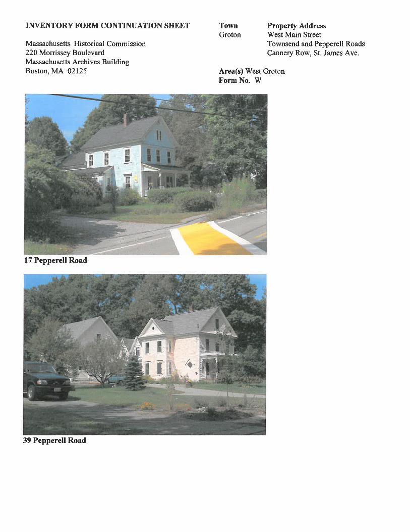
West Main Street is the principal thoroughfare in West Groton and passes east to west at the southern end.The site of the current West Main Street Bridge over the Squannacook River was occupied by an earlypredecessor by 1795. Most residential development took place between the junction ofPepperell Road and thehouse at 111 West Main Street, approximately a half mile to the east, during the mid to late 19th century,although there are approximately five residences from the Federal Period. Victorian Period houses tend to besmaller and less refIned in their designs than their Federal counterparts with the exceptions of 65 and 74 WestMain Street and 17 and 39 Pepperell Road.

Area(s) West GrotonForm No. W
INVENTORY FORM CONTINUATION SHEET
Massachusetts Historical Commission220 Morrissey BoulevardMassachusetts Archives BuildingBoston, MA 02125
TownGroton
Property AddressWest Main StreetTownsend and Pepperell RoadsCannery Row, St. James Ave.
The older buildings on West Main Street were built in the early 19th century and are located closer to the westend. The Rockwood House at 13 West Main Street (MIIC #126) was built c. 1800 with symmetricalfenestration in the fayade and small window openings. The Abel Tarbell House at 16 West Main Street(MIle #124) was built of brick c. 1800 and occupied a site overlooking the river and the early mill site. Thehouse at 54 West Main Street is of a smaller scale and lesser quality design but appears to retain someelements of early construction such as the low comer post height. The house at 17-19 West Main Street mayhave been built during the early 19th century and exhibits a 2 Y2-story, 5x3-bay, ridge-hipped form, and mayhave been built as a two family house. The easternmost late 18th-early 19th century house in the West MainStreet Area is the Graves-Blood House at 94 West Main Street (MIIC #122). The brick construction,symmetrical fayade, large barns and surrounding fields lend some prominence to the farm that is now in use asan abattoir. It is a 4xl-bay, side-gabled, 2 l/2-story building with a 2-story ell attached to the south (rear).Outbuildings include three barns and a silo visible from the road in addition to two more outbuildings to thesouth. The house is located close to West Main Street and is the only commercial agricultural operation in thevillage.
Buildings on West Main Street from the second half of the 19th century include the Victorian Eclectic styleSquannacook Hall at 33 West Main Street (MHe #266) and the Stick style Christian Union Church at 35West Main Street which are the area's most ornate buildings from the period. The numerous wood frameVictorian Eclectic style houses, however, most of which are two to two and one half stories in height, arepredominant. An unusual local design appears in the house at 25 West Main Street which has elements of theGothic Revival style although it appears from the Shingle style elements to have been built after 1850, the timeof that style's popularity. Other unusual designs for West Groton are the two front-gabled, 2-story houses at64 and 68 West Main Street which are distinguished by their low-pitched roofs, a form that appears in manymill villages in Massachusetts but not elsewhere in Groton. Many well-preserved Victorian Eclectic examplesexist, including those at 65 West Main Street which is a 2 Y2-story, cross-gabled form with a prominent gablefront cornice, three-sided bay window and carved brackets over the side-hall entry. It appears to have beenbuilt for a client with above average means by virtue of its size and site upon a low hill set back from the road.A house of similar scale and design quality exists at 74 West Main Street which lacks the elevated setting butincludes a gable front barn clad in wood clapboards built c. 1900. More typical of the street are the houses at91, 93 and 95 West Main Street which share a common design and appear to have been built at the sametime, c. 1900. These are closely spaced 1 Y2-story, front-gabled forms with two-bay facades, gable returns,side-hall entries and center brick chimneys. The most intact example of the three is at 9S West Main Street.Other 19th century houses on West Main Street are mainly Victorian Eclectic style examples with alterationssuch as vinyl and aluminum siding, enclosed porches and structural additions. The Clover Leaf Store at 9West Main Street, built c. 1880, is a small, front-gabled, wood frame grocery store that faces south and issited immediately adjacent to the intersections of Pepperell Road, Townsend Road and West Main Street. Aflat-roofed storefront with display windows and vintage sign above appear to be unaltered from the mid 20th
century.

Area(s) West GrotonForm No. W
INVENTORY FORM CONTINUATION SHEET
Massachusetts Historical Commission220 Morrissey BoulevardMassachusetts Archives BuildingBoston, MA 02125
TownGroton
Property AddressWest Main StreetTownsend and Pepperell RoadsCannery Row, S1. James Ave.
Buildings from the 20th century are interspersed with earlier development but do not define the character of thearea to as great a degree as the Victorian residences. The Squannacook Engine House No. 2 was built ofbrick in 1958 at 46 West Main Street and has a relatively small side-gabled one-story fonn. A Ranch stylehouse at 34 West Main Street was built c. 1950 and is set back farther than usual from the road. Also, theHale Village retirement condominiums, built c. 1990, exist at 56-58 West Main Street and blend well due totheir scale and close proximity to the previously existing houses.
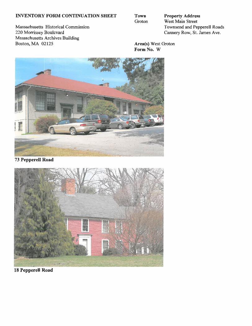
Pepperell Road is the site of approximately 16 buildings, most of which are residential. Historic examplesalong this section of road are wood frame houses of 1 ~ to 2 ~ stories in height and are in fair to excellentcondition. Pepperell Road predates Townsend Road as an alternate route into West Groton and appears inplace on the 1832 Butler map. The oldest house on the road in the village is the wood frame Sedley House at18 Pepperell Road (MHC #127), built c. 1740 in the Colonial style. More common are the Victorian Eclecticdesigns such as those at 17 and 39 Pepperell Road which are both 2 ~-story, front-gabled, wood shingledhouses with attached barns that appear to have been built at the same time as the houses, c. 1890.Architectural details common to both examples are the patterned wood shingles in the front gable peaks,brackets either at the eaves or at the cornice of the porches and ells projecting to the south, creating complexroof and floor plans. Additional Victorian Eclectic style houses of 2 Y2 stories are at 25, 51, and 55 PepperellRoad, the latter having a detached carriage bam from around the time of original construction, c. 1900. Thehouses at 13 and 37 Pepperell Road are less ornate but are likely older. The minimal detail reveals simple 1 Y2- 2-story side-gabled forms that are common to buildings from the 1850s, the time when these parcels are fIrstoccupied on historic maps. Pepperell Road has the highest concentration ofmodern houses with four, locatedat 4, 42, 48 and 56. At the northern end of the area, the Tarbell School at 73 Pepperell Road occupies acomer lot at S1. James Avenue. The 1914 Bungalow and Colonial Revival style school building, now in use asadministrative offices for the school department, is built ofyellow brick and is comparable in scale, design andmaterials to the Boutwell School on Hollis Street in Groton Center.
Townsend Road is the site of additional Victorian Eclectic style houses, also from around the turn of the 20th
century. Four examples with front-gabled, 2-story fonns exist at 28, 48, 40and 60 Townsend Road. Thelatter two are more well-preserved with original cladding and details such as carved brackets supporting entryporches, gable returns and bay windows. The house at 66 Townsend Road is 2 ~ stories tall, clad inaluminum clapboards and has a detached bam from c. 1900 as well as a detached garage from c. 1950. Thecement block garage built c. 1920 at 30 Townsend Road has stepped gables and quarry-faced cinderblockconstruction.
S1. James Avenue is the site of two buildings. The modem house at the eastern end was built c. 1990. The St.James Catholic Church on the north side of the street was built in 1929 by the priest at the time and hisparishioners. The cobblestone construction is unique in West Groton as is the scale although some details,while rendered in stone, are similar in concept to those on the Christian Union Church at 35 West MainStreet. The bell tower, gabled entry porch on the east side and the arched stained glass windows stand out in

Area(s) West GrotonForm No. W
INVENTORY FORM CONTINUATION SHEET
Massachusetts Historical Commission220 Morrissey BoulevardMassachusetts Archives BuildingBoston, MA 02125
TownGroton
Property AddressWest Main StreetTownsend and Pepperell RoadsCannery Row, S1. James Ave.
this regard. Buttresses of cobblestone and cut capstones, segmental arched window openings done incobblestone and the Gibbs surround at the main entry reflect a locally unusual English Revival influence notfound in town other than in the Chapel on the Groton School Campus. The remainder of the land on S1.James Avenue is given over to parking for the church and Tarbell School at 73 Pepperell Road, leaving animpression of decreased density at the northern edge of the West Groton Area.
Selected Descriptions
Squannacook Hall at 33 West Main Street is an institutional scaled, 3x5-bay, front-gabled, VictorianEclectic style building of 2 1/2-stories. The side-hall entry is covered by a gable-roofed porch with clippedgable, exposed rafter ends and a 3-pane transom. Decorative features include the clipped gables in the frontand rear elevations, gable returns, comer boards and the band ofwood shingles laid across the fa9ade betweenfloors in stagger-butt and sawtooth patterns. Windows are mainly 6/6 double-hung sash with hoods;exceptions are the paired 4/4 double-hung units in the center bay of the second story, the rose window in thefront gable peak and the small awning windows in the west side of the first story of the fa9ade that occupy thespace formerly occupied by the fIre engine door. The building is in fair condition due to its vinyl siding, thePlexiglas storm window over the rose window in the gable peak and the addition of the concrete ramp at thefront door. The building, one of a few institutional designs on the densely residential West Main Street,occupies a narrow parcel with pavement on the east side and little in the way of landscaping. Alterationsinclude the infIll of the original vehicle door in the west side of the fa9ade and construction of an entry porchover the pedestrian door in the east.
The three by three-bay Christian Union Church at 35 West Main Street is a highly ornate yet relativelysmall example of Stick style design. The building, unique in West Groton, has a cross gabled form of twostories, a square tower between the gabled roof sections capped by a bell turret, pyramidal roof and finial. Thebase of the tower has an open gale-roofed porch covering the main entry. Decorative features are numerousand include the spindle frieze in the bell turret and the porch, carved gable ornaments with quatrefoils andtrefoils at the two main gables and in the gable of the entry porch, comer boards, comer brackets, peakedwindow hoods, stagger-butt shingles in the gable peaks over wood clapboards below, beltcourses between thedifferent siding materials arched stained glass window in the fa9ade, an oculus in the side gable and doublehung stained glass windows in the remaining openings. A brick addition was made to the rear of the church inthe 1950s adjacent to the original side-gabled rear ell. The church is well maintained and adds a level ofrefInement to the west end of the road.
The Federal style Tarbell House at 16 West Main Street (MHC #124) is a brick 5x3-bay, side-gabled 2 1/2story house with a rear wood-frame ell of 1 story. Decorative features are the symmetrical fenestration in thefa~ade, molded cornice, four tall brick chimneys at the comers of the roof and gable returns. Windows are 6/6double-hung sash with plain trim, stone sills and no lintels or arches over the openings. The center entry hassimple trim and a transom; a secondary entry exists at the southwest comer of the west side elevation. Therear ell is a wood clapboard, 4-bay, gable form with a single brick chimney near the center of the roof ridge.
Area(s) West GrotonForm No. W
INVENTORY FORM CONTINUATION SHEET
Massachusetts Historical Commission220 Morrissey BoulevardMassachusetts Archives BuildingBoston, MA 02125
TownGroton
Property AddressWest Main StreetTownsend and Pepperell RoadsCannery Row, St. James Ave.
The house is well-maintained and is a locally rare brick Federal style example. The setting is adjacent to therailroad, just west ofwhich is largest building in West Groton, the former Groton Leatherboard factory, now inuse as senior housing; west of the factory is the Squannacook River
The former Groton Leatherboard factory (MIIC #s 182-188), now the River Court retirement community,was built of brick in several stages during the early 20th century. The very low-pitched bracketed, gableroofed, one-story principal elevation faces north from its site at the west end of West Main Street. A pair ofbrick two-story masses project to the rear or south and form a roughly U-shaped complex. Entry to thecomplex is through the covered drive east of the northern building. Parking and green space occupy thecourtyard. The complex is the area's largest resource and occupies a site immediately adjacent to theSquannacook River, the 1996 West Groton Bridge, the junctions of West Main Street, Townsend Road andPepperell Road. Within the last decade, it was the subject of a certified rehabilitation and adaptation for use ashousing which resulted in its listing in the National Register of Historic Places in 2002.
The Asa Tarbell House at 6 West Main Street (MHC #125) is an ornate brick house with elements of theFederal style, built c. 1800. The five by two bay form has a side-gabled roof, symmetrical fenestration in thefal(ade and a center entry. Decorative features are the corbelled eaves, gable returns and four tall chimneys atthe comers of the roof. Windows are 6/6 double-hung sash with flat brick arches above. The entry is trimmedwith sidelights and a transom. A shed-roofed porch covers the north side of the first story of the fal(ade.
The former Sampson Mill on Cannery Row is west of the southern end of Townsend Road adjacent to theSquannacook River. The complex of buildings appears to have wood shingle exterior with elements of theBungalow and Colonial Revival styles. It is likely that significant repairs have been made which are difficultto discern. Buildings here are 1-2 stories in height with shallow pitched gable roofs. The complex containstwo large buildings, perhaps 30'x70' and four cabin sized outbuildings in use as woodworking shops.
Landscape Features
The area north of the east abutment of the West Groton Bridge is a small park that is the former site of theWest Groton Station. Grass, flowers, a parking lot and a bench now occupy the site overlooking the river andthe mill pond south of the former Sampson Mill. The diminutive size of the .16 acre park is consistent withthe relatively dense development that characterizes West Groton, however, there is a parcel of privately ownedopen space between the houses at 16 and 34 West Main. Also, the farm at 94 West Main Street adds anagricultural sensibility to the east end of the area.
Conclusion/Comparison
West Groton is the town's principal village outside the larger Groton Center and contains a higher level ofbuilding density than other parts of the town due to the small lots. The Christian Union Church, SquannacookHall and modem Fire Station give it a civic fimction while commercial activity continues to take place at the

Area(s) West GrotonForm No. W
INVENTORY FORM CONTINUATION SHEET
Massachusetts Historical Commission220 Morrissey BoulevardMassachusetts Archives BuildingBoston, MA 02125
TownGroton
Property AddressWest Main StreetTownsend and Pepperell RoadsCannery Row, St. James Ave.
Clover Leaf Store at 9 West Main Street. The intersection of five streets in front of the store, the bridge overthe Squannacook and the former leatherboard mill adjacent to the south are primarily responsible for thecharacter of the village and defme the core of the surrounding area. While synthetic siding has been applied toseveral houses and the Squannacook Hall, most buildings retain their original exterior materials. Most historicarchitectural design features also survive. The design of the West Main Street Bridge, built on a modest scalein 1996 to replace its 1915 predecessor, has been carried out with ornamental concrete balustrades and doesnot appear as an inappropriately large modem piece of construction. It also incorporates a stone date plaquefrom the earlier structure, lending some sense of the history of the river crossing.
mSTORICAL NARRATIVE:Explain historical development of the area. Discuss how the area relates to the historical development of the town. SeeContinuation Sheet X
Introduction
Prior to settlement by Europeans, the area of West Groton was the site of Native American travel along theSquannacook River for its supply of freshwater fish and of overland travel along the current route of WestMain Street. A fordway is also thought to have existed near the current West Groton Bridge before 1655.While the Town of Groton was the site of around 300 settlers by 1675, very few lived in the village of WestGroton. Attacks by Native Americans on the white population from 1676-1724 slowed growth of the town,particularly in areas away from the town center and in the west part of town along watercourses whichfacilitated travel by raiding parties. Subsequent settlement occurred around the bridge and mills built here bythe 18th century but agriculture remained the predominant activity. Nineteenth century industrial activityincreased both in West Groton and a mile to the north at the current site of the Hollingsworth and Vose papermills and coexisted with farming as a way of life into the 20th century. Perhaps eleven families lived in thearea by the mid 1800s according to maps from 1847 and 1875, a number that remained fairly constant until thelate 19th century. After that time, development increased as a result of growing employment opportunitiesoffered by the expanded Groton Leatherboard and Sampson Reel mills. Judging by the approximate dates ofthe houses in the village, the growth of the late 19th century and very early 20th century was short lived andresulted largely in the collection of historic resources we see today.
Colonial Period 1675-1775
Francis Marion Boutwell has stated in "Old Highways and Landmarks of Groton, Massachusetts" that themajority of Groton residents lived close together along Main and Hollis Street in Groton Center during theperiod of first settlement, although pressure to expand the population and bring additional acreage undercultivation led in 1713 to the first of five subsequent divisions of publicly held lands. The MassachusettsHistorical Commission Town Report for Groton notes that there were a few scattered farms on the west side ofthe Nashua River by 1710, promoting settlement of the village of West Groton as a secondary locus of thetown by 1750, perhaps as a result of the land division process. Grist, saw, dye and carding mills existed on the

Area(s) West GrotonForm No. W
INVENTORY FORM CONTINUATION SHEET
Massachusetts Historical Commission220 Morrissey BoulevardMassachusetts Archives BuildingBoston, MA 02125
TownGroton
Property AddressWest Main StreetTownsend and Pepperell RoadsCannery Row, St. James Ave.
Squannacook River by 1744 run by Thomas Tarbell, former town clerk from 1704-1705, 1731-1733 and from1745-1756 (These offices may have been ftlled by more than one man named Thomas Tarbell. There were 6males named Thomas, all related to each other but of different generations born between c. 1646 and 1758. ).Additional owners of the mill privilege in the 18th century were Jonathan Morse and Samuel Woods. Travelfrom West Groton to Groton Center, presumably over West Main Street, Long Hill Road and Farmers Row,was facilitated by construction across the swampy ground of the slightly elevated central section ofBroadmeadow Road near Groton Center in order to provide the western residents with easier access to theFirst Parish Church, rebuilt in 1714-1716. Also, the MHC report notes that secondary radial roads in the townincluding Townsend and Pepperell Roads were built or extended. Butler notes in his 1848 history of Grotonthat there were five bridges over the Nashua and Squannacook Rivers by 1750, one of which was likely tohave been in the vicinity of the current village. Carl Condit, in the first of his two volume work entitledAmerican Building Art, describes bridges from the period as pile and beam structures which means that woodpilings driven vertically by hand into the river bed were joined by horizontal beams, perhaps supported at thecomers by diagonal braces such as are found in a timber frame house. The beams supporting the deck were nomore than 15' to 20' in length, thus requiring several short spans to cross the river. Condit notes that floatingbridges also existed in the region at the time but it is not known which type was used here.
Disagreements between Native Americans in the region and the European settlers in Groton and elsewherewere rife for a period of nearly 50 years beginning in 1676 and lasting until the final attack on a Groton farmerin 1724 or 1725. The earliest attacks took place in the town center but later the Native Americans grew morelikely to attack outlying residents west of town and west of the Nashua River. While no sources indicatespecifically that such activities took place within the village of West Groton, the possibility exists and thethreat of attack probably played a role in the gradual settlement of the area.
Voters of Groton directed selectmen in 1681 to form a school at public expense. Little is known about itslocation or curriculum and, since there is nothing further in the record on the subject until 1703, it is likely thatthe school was established and in operation at that time. The number of locations for schools increased to fivein 1741 and seven in 1742; among them may have been West Groton.
Federal Period 1775-1830
Travel routes to West Groton along Long Hill Road and West Main Street were in use by the white occupantsat the time of the 1795 Prescott map of Groton which depicts a bridge and a mill on each side of theSquannacook River at the current sit of the former Groton Leatherboard Mill (now the River Court retirementresidences at 8 West Main Street). It was in the late 18th century that American bridge builders learnedconstruction of masonry coffer dams, which offered better footing in the river bed, and of the truss bridge, aform that allows for increased length of spans and hence increased durability in the face of flooding streams.Although it is not documented that Groton benefited from these improvements immediately upon theiravailability, it is possible that news of the two-span truss bridge over the Connecticut River between NewHampshire and Vermont built in 1785 and of the multi-span bridge comprised of several short spans and two
Area(s) West GrotonForm No. W
INVENTORY FORM CONTINUATION SHEET
Massachusetts Historical Commission220 Morrissey BoulevardMassachusetts Archives BuildingBoston, MA 02125
TownGroton
Property AddressWest Main StreetTownsend and Pepperell RoadsCannery Row, St. James Ave.
intermediate trusses in Newburyport, reached the town at some point. Green notes on page 137 of Volume 3of his town history that bridges in Groton in 1790 were made of wood which was a potential material for atruss bridge or a pile and beam. bridge.
The Tarbell grist and saw mill remained in operation at the former Groton Leatherboard site through theFederal Period. Most businesses were conducted in merchants' houses in town at the time although no knownexamples of this arrangement exist for the village of West Groton. While industrial activity was increasing,the majority of West Groton residents remained involved in agriculture as a means of making a living. Cropswere mainly for subsistence although some were undoubtedly shipped to Lowell after that city's founding latein the period. Fruit would have been a particularly common cash crop. Butler's notes from 1828-1829indicate the route from Groton Center to West Groton was called the Road to Squannacook. Dr. Green statesthat a chapel was built at West Groton on the Pepperell Road in 1827 for Reverend John Todd, the town's firstCongregational minister in 1825. This may be the house at 13 Pepperell Road.
Architecture
The brick house at 16 West Main Street (MHC #124) is described in Caleb Butler's field notes from 18281829 as it currently exists: a two-story brick house with four chimneys and five windows across the front. Itwas owned by Abel Tarbell whose occupancy is depicted on the 1832 Butler map. An owner named A.Tarbell is shown on the 1847 and 1856 maps and was likely the same person. Mr. Tarbell may have been adescendant of the Colonial Period miller who operated a grist and saw mill starting in 1744 on the oppositeside of the future railroad right of way. He was taxed in 1830 for ownership of a house valued at $2,500. By1847, his property was worth $3,000 and he had additional real property and personal assets worth $5,000.The 1855 census reveals that Mr. Tarbell was born c. 1773 and had the title "Esquire". He also served asMaster of the Groton Masons Lodge and is given the title Colonel in Butler's history of the town.
Ezra Graves is the first known owner of the house at 94 West Main Street (MHC #122) based on Butler's1832 map. From c 1847-1889, it was under ownership of Edmund Blood, the first ofmany generations of thefamily who continue to occupy the house. Mr. Blood was, according to the census from 1855, born c. 1804,married to Mary Blood, working as a farmer with two children, Edmund L. Blood among them.
The House at 6 West Main Street (MIIC #125) is described in Caleb Butler's field notes from 1828-1829 asit currently exists: a two-story brick house with four chimneys and five windows across the front. It wasowned from c. 1832-c. 1847 by Asa Tarbell, neighbor and relative of Abel Tarbell of 16 West Main Street.Mr. Tarbell was a Master of the St. Paul's Lodge of Free and Accepted Masons of Groton. A subsequentowner was John Tarbell who is listed as a watchmaker in the census from1855. His relative, Asa, is also listedas an occupant and a yeoman.

Area(s) West GrotonForm No. W
INVENTORY FORM CONTINUATION SHEET
Massachusetts Historical Commission220 Morrissey BoulevardMassachusetts Archives BuildingBoston, MA 02125
Early Industrial Period 1830-1870
TownGroton
Property AddressWest Main StreetTownsend and Pepperell RoadsCannery Row, S1. James Ave.
Travel routes to West Groton from Groton Center were well established by the start of the period. However,the alignment of the bridge over the Squannacook River may have been modified between the time ofthe 1832Butler map and the 1856 Walling map. The former suggests but does not indicate with certainty that thebridge departed the Groton side of the river near the current location. The 1856 map depicts the bridge a shortdistance south of the current location and near the current south side of the River Court retirement residences.Also, the 1856 map shows a road east of and parallel to the bridge access road that may now correspond to theRiver Court driveway. (The current River Court buildings, built from 1915-1933, were preceded by smallermills nearer the river.) Another development in travel routes was the establishment c. 1846 of the TownsendRoad from the village to the north. Also, construction of the Peterborough and Shirley Railroad, whichconnected the towns of its name, was completed through West Groton in 1847. Given the accurate location ofTownsend Road on the 1847 Butler map and the slightly incorrect alignment of the railroad on the same map,it is likely that the road pre-dated by a short time the construction of the railroad which may have still been inthe planning stage when the map was drawn. (The railroad is accurately depicted on most subsequent maps asimmediately west of the segment of Townsend Road between the village and Kemp Street to the north.) Therailroad station in the village was located on the vacant parcel now reused as a small park northwest of theintersection ofWest Main Street, Pepperell and Townsend Roads.
Industrial activity increased with the construction of the railroad. While there had been a grist and saw mill inthe village since the 18th century, the mid 19th century industrial expansion throughout the region attractedpaper manufacturers to West Groton at the current site of the Hollingsworth and Vose plant north of thevillage and within the village adjacent to the grist and saw mill. Howe's Paper Mills are depicted on the 1856Walling map at this location. This probably refers to Oliver Howe who Dr. Green describes as a miller ofManila paper starting in 1841 and who also owned mills outside the village on the Nashua River where thecurrent State Route 119 crosses. John Hayward, author of the 1857 gazetteer of Massachusetts, states that ofthe several paper mills in town, the biggest was in West Groton, probably indicating the Hollingsworth mills tothe north. Although the 1846 industrial products statistics do not differentiate between establishments, theleading industry in Groton continued to be papermaking at the two Howe factories employing a total of 12 atthe crossing of the Nashua River on Main Street and here in West Groton. The number of paper employeesincreased to 43 by 1855 although industries in South Groton, also called Groton Junction and later the separateTown of Ayer, had eclipsed the paper business in volume. Construction of the mills in the village as well asthe railroad encouraged the establishment of the West Groton Post Office in 1850.
Dr. Green notes that there was in 1868 only one store in the village, a situation that remained until at least thetime of the publication of his 1884 pamphlet "The Old Stores and the Post Office of Groton". Other retailactivity took place at the Blood Farm at 94 West Main Street in the form of livestock butchering. EliotBlood, the current owner of the slaughterhouse, which is still in business, has a butcher's license issued to hisancestor Edmund Blood in 1854. The population of the village, based on the number of houses depicted onhistoric maps, was in 1832 around 30; in 1847 around 45 and around 60 in 1856. The village was in 1862 the
Area(s) West GrotonForm No. W
INVENTORY FORM CONTINUATION SHEET
Massachusetts Historical Commission220 Morrissey BoulevardMassachusetts Archives BuildingBoston, MA 02125
TownGroton
Property AddressWest Main StreetTownsend and Pepperell RoadsCannery Row, St. James Ave.
birthplace of Edmund Tarbell, nationally renowned artist, head of the faculty at the Boston Museum of FineArts and painter ofpresidents Wilson, Coolidge and Hoover.
Architecture
The house at 54 West Main Street, which does not appear on the 1832 map, was owned in 1847 by WilliamKemp Jr., a laborer and miller born c. 1815 and in 1856 by Frederick Adams (who also owned a second housenorth of the village), a yeoman born c. 1807 according to 1855 census information. It is a modest building incomparison to others in the area and suggests Mr. Kemp and Mr. Adams were working class residents,possibly employed at one of the local the paper mills. The house at 75 West Main Street was occupied in1847 and in 1856 by L. Shipley and, being built on a similar scale, fits into the same category as 54 West MainStreet. 13 Pepperell Road was occupied in 1847 by Sewall Rockwood, a farmer born c. 1783 according to the1855 census. Later in the period, this was the first meeting place of the Christian Union Society of WestGroton before the construction of their permanent building at 35 West Main Street, built in 1885. In 1856, theowner was Harrison J. Hartwell who worked as a papermaker according to 1855 censuses. He may also haveworked at the former Hartwell mill north of the village that was sold to Lyman Hollingsworth in 1853.Residents named Smith and Emmerson shared ownership of a building that no longer exists but was located onthe site of the modem Hale Village retirement community. Edmund Blood, owner of the Federal style houseat 94 West Main Street from at least 1847 - 1856, operated his slaughterhouse on the site. A schoolhousewas built c. 1870 near the site of the Christian Union Church but was replaced in 1914 with the existingTarbell School at the comer of Pepperell Road and S1. James Avenue.
Late Industrial Period 1870-1915
By the start of the Late Industrial Period, the alignment of the bridge over the Squannacook River had beenaltered to its current location according to the Beers atlas of 1875 which also shows the curved dam in itscurrent location. The bridge that preceded the current structure was built in 1915 according to the stone plaquethat has been re-integrated into the existing design. Population of the village, based on the depiction of 14houses on the 1875 atlas, was around 70 people. Dr. Green noted that the formerly small settlement known asSquannacook Village had "sprung up" by the end of the 19th century to a population in 1889 of around 100according to the atlas of that year. Settlement of the village remained densely gathered around the mills andthe junction of West Main Street, Pepperell and Townsend Roads. This pattern would become more spreadout in the first decade of the 20th century with the construction through West Groton of a street railwaybetween Ayer and Greenville, New Hampshire.
The Tarbell School was built near the site of 25 West Main Street between 1856 and 1875. Previously,youngsters attended school at the District School #4 at the comer of Kemp Street and Pepperell Road whichhad been built prior to 1832, the time of construction of brick schools on Chicopee Rowand at 76 FarmersRow. The increase in population resulted in the establishment of the West Groton Branch of the GrotonPublic Library. This was located in the Tarbell School (now demolished; this was the predecessor to the
Area(s) West GrotonFormNo. W
INVENTORY FORM CONTINUATION SHEET
Massachusetts Historical Commission220 Morrissey BoulevardMassachusetts Archives BuildingBoston, MA 02125
TownGroton
Property AddressWest Main StreetTownsend and Pepperell RoadsCannery Row, St. James Ave.
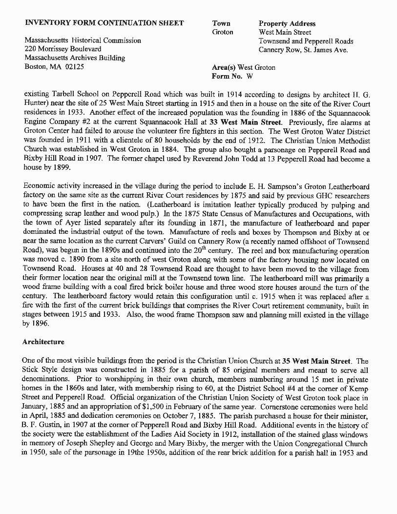
existing Tarbell School on Pepperell Road which was built in 1914 according to designs by architect H. G.Hunter) near the site of25 West Main Street starting in 1915 and then in a house on the site of the River Courtresidences in 1933. Another effect of the increased population was the founding in 1886 of the SquannacookEngine Company #2 at the current Squannacook Hall at 33 West Main Street. Previously, fire alarms atGroton Center had failed to arouse the volunteer fIre fIghters in this section. The West Groton Water Districtwas founded in 1911 with a clientele of 80 households by the end of 1912. The Christian Union MethodistChurch was established in West Groton in 1884. The group also bought a parsonage on Pepperell Road andBixby Hill Road in 1907. The fonner chapel used by Reverend John Todd at 13 Pepperell Road had become ahouse by 1899.
Economic activity increased in the village during the period to include E. H. Sampson's Groton Leatherboardfactory on the same site as the current River Court residences by 1875 and said by previous GHC researchersto have been the fIrst in the nation. (Leatherboard is imitation leather typically produced by pulping andcompressing scrap leather and wood pulp.) In the 1875 State Census of Manufactures and Occupations, withthe town of Ayer listed separately after its founding in 1871, the manufacture of leatherboard and paperdominated the industrial output of the town. Manufacture of reels and boxes by Thompson and Bixby at ornear the same location as the current Carvers' Guild on Cannery Row (a recently named offshoot of TownsendRoad), was begun in the l890s and continued into the 20th century. The reel and box manufacturing operationwas moved c. 1890 from a site north of west Groton along with some of the factory housing now located onTownsend Road. Houses at 40 and 28 Townsend Road are thought to have been moved to the village fromtheir former location near the original mill at the Townsend town line. The leatherboard mill was primarily awood frame building with a coal fIred brick boiler house and three wood store houses around the turn of thecentury. The leatherboard factory would retain this confIguration until c. 1915 when it was replaced after afIre with the fIrst of the current brick buildings that comprises the River Court retirement community, built instages between 1915 and 1933. Also, the wood frame Thompson saw and planning mill existed in the villageby 1896.
Architecture
One of the most visible buildings from the period is the Christian Union Church at 35 West Main Street. TheStick Style design was constructed in 1885 for a parish of 85 original members and meant to serve alldenominations. Prior to worshipping in their own church, members numbering around 15 met in privatehomes in the 1860s and later, with membership rising to 60, at the District School #4 at the comer of KempStreet and Pepperell Road. Official organization of the Christian Union Society of West Groton took place inJanuary, 1885 and an appropriation of$I,500 in February of the same year. Cornerstone ceremonies were heldin April, 1885 and dedication ceremonies on October 7, 1885. The parish purchased a house for their minister,B. F. Gustin, in 1907 at the comer ofPepperell Road and Bixby Hill Road. Additional events in the history ofthe society were the establishment of the Ladies Aid Society in 1912, installation of the stained glass windowsin memory of Joseph Shepley and George and Mary Bixby, the merger with the Union Congregational Churchin 1950, sale of the parsonage in 19the 1950s, addition of the rear brick addition for a parish hall in 1953 and

Area(s) West GrotonForm No. W
INVENTORY FORM CONTINUATION SHEET
Massachusetts Historical Commission220 Morrissey BoulevardMassachusetts Archives BuildingBoston, MA 02125
TownGroton
Property AddressWest Main StreetTownsend and Pepperell RoadsCannery Row, St. James Ave.
addition of stained glass windows in memory of Mr. and Mrs. Elliot Blood Sr. and a stained glass windowgiven by Edna Dargis and Mr. and Mrs. Roland Sawyer. The church remains an active part of the WestGroton community and is one of two remaining churches in the village. The Catholic St. James Church is onSt. James Avenue and was built in 1929.
The Squannacook Hall and Engine Company #2 was built next door to the Christian Union Church at 33 WestMain Street in 1887. One year prior, a volunteer fire company in West Groton was formed of "good, active,young men" who kept the town's oldest fire engine, the "Torrent" built by the engineer Loammi Baldwin Jr. in1802, on the property of a private individual in a shed that allowed changes in weather to deteriorate theapparatus. The problem of equipment storage was addressed by construction of Squannacook Hall and EngineHouse for the Engine Company #2 while fire whistles were blown at the nearby leatherboard factory until the1950s. This was the town's second fIrehouse, the other being located in Groton Center. The entire town at thistime employed 3 engineers and 69 men, 25 of whom were in the Squannacook Company. The residentdirectory from 1888 lists Patrick Kane as the foreman of the company, John Dugan as the assistant foremanand W. V. Bixby as the clerk. Twenty fIve men served in the company at that time. Originally, the fa~ade ofthe building had a side hall entry with no porch in the east side and a vehicle door for the "Torrent" in the west.Construction, which cost $2,462.97 ($962.67 over budget), was carried out by 13 different men listed in townreports as laborers who earned between $1.90 and $58. George Woods, however, earned $498 for his laborwhich suggests him as the primary builder on the job. A public meeting hall was located on the upper floorand furnished with settees and a stove. Uses of the building included the fire station (a purpose it served untilconstruction across the street of a new brick station in 1958), fIrst meeting place for the West Groton WaterSupply District in 1911, meeting place for the boy scouts starting in the 1940s and the West GrotonCommunity Club which sponsored athletic events, village improvement projects, fIeld days, dances andholiday parties starting in 1946. Renovations to Squannacook Hall in 1977 provided for the building's use byGroton's senior citizens which continued until 1996 when the Council on Aging moved east to the formerVFW building on West Main Street.
Older houses changed ownership in some cases including 6 West Main Street which was owned in 1875 byAdams Archibald, a Canadian-born lumber agent and C. H. Bixby in 1889. Mr. Archibald was in 1865 listedin the census as the depot master. E. H. Sampson, the owner of the former Groton Leatherboard mill, ownedthe house at 13 West Main Street between 1875 and 1889 and G. W. Canney had ownership of the house at54 West Main Street in 1889. Houses built from 1870-1915 include most of those on West Main Street. Thehouse at 74 West Main Street appears to have been occupied by L. E. Williams in 1889. Edmund Blood,owner of the farm at 94 West Main Street, had the houses at 91 and 93 West Main Street built around 1889with money he earned from the sale ofhis land for construction of the branch of the Peterborough and ShirleyRailroad located east of the village. Other houses on the street built during the later part of the period include41,55,57,59,65,81,85,95 and 111 West Main Street. Houses on Pepperell Road that have constructiondates between 1870 and 1915 include those at numbers 17, 39, 51 and 55. Townsend Road has a similarnumber of houses from the period including numbers 28, 40, 48, 56 and 60. The house at 66 Townsend Roadappears on the 1889 atlas to have been owned by T. Leonard. Most un-attributed houses post-date the

Area(s) West GrotonForm No. W
INVENTORY FORM CONTINUATION SHEET
Massachusetts Historical Commission220 Morrissey BoulevardMassachusetts Archives BuildingBoston, MA 02125
TownGroton
Property AddressWest Main StreetTownsend and Pepperell RoadsCannery Row, 8t James Ave.
publication of the 1889 Walker atlas which is the primary source for construction dates in the Late IndustrialPeriod. The Clover Leaf Store at 9 West Main Street was built as a grocery store for C. H. Bixby c. 1878.
Early Modem Period 1915-1945
Based on the fact that approximately 38 residences existed in the village in 1930, there were an estimated 190residents. The population was involved mainly in manufacturing although there were at least 8 residents whoowned more than one house, suggesting rental properties, possibly for mill employees unable to purchase theirown homes, were a source of income for several in West Groton. Mill employees were increasingly of Irishdescent judging by the surnames on the 1930 map by Dana Somes and worked at either the Sampson box andreel mill at the current site of the Carvers' Guild on Cannery Row, the Groton Leatherboard mill (now theRiver Court retirement community) south of the junction of West Main Street, Townsend and Pepperell Roadsor north of the village at the Hollingsworth and Vose paper mill. A major change in the appearance of thevillage came in 1914 with the destruction by fire of the wood frame Groton Leatherboard mill which wasrebuilt in brick shortly thereafter. In 1930, Qua Stone wrote in his History ofMassachusetts Industries that theGroton Leatherboard had acquired a single client in New York City called the Certified Dry Mat Corporationwhich sold the Groton Product to 400 newspapers across the country. Principal employees were WinthropSheedy, President; Carl A. P. Lawrence, Vice President and Michael Sheedy, Treasurer.
The St. James Catholic Church was built of cobblestone in 1929 on the street that bears its name. Commercialactivity beyond manufacturing included the small scale operations of the C.H. Bixby (also called the BixbyWebber Company in the 1918 resident directory) general store at its current site (9 West Main Street), a pooland bowling hall at an unknown location run by J. Philonnn Duquette and a garage, possibly for repair ofautomobiles and probably located in the cast cement block building at 30 Townsend Road, run by Noble A.Nutt. The current post office at 1 Pepperell Road was said by Boston University researchers to have been builtc. 1860 as a storehouse for the Bixby Store and was adapted for use as a post office c. 1930. The building(without street number, assessor #101 12) at the northern side of the east abutment of the bridge over theSquannacook was built sometime prior to 1896 and after 1889 according to Sanborn fire insurance maps andthe Walker atlas. It is depicted as a residence with a porch across the east facing fa~ade.
Architecture
Architecture from the period that highlights the character of the village includes the S1. James Catholic Churchat 29 St. James Avenue, built in 1929. Along with the parishioners, the priest, Edward Mitchell, took aprominent role not only in the fundraising but in the construction, hauling stone from Townsend in a wagon,overseeing construction, acquiring recycled building materials and personally laying up stone. The architectwas William B. Colleary ofBoston who drew the plans in 1924.
The Groton Leatherboard mill, incorporated in 1899, operated in a wood frame building until 1914. Duringthis period, there were two stock houses and a dry house, also of wood, south of the mill which occupied the

Area(s) West GrotonForm No. W
INVENTORY FORM CONTINUATION SHEET
Massachusetts Historical Commission220 Morrissey BoulevardMassachusetts Archives BuildingBoston, MA 02125
TownGroton
Property AddressWest Main StreetTownsend and Pepperell RoadsCannery Row, St. James Ave.
current site. A small brick building housed a coal-fired boiler at the east side of the complex and was oppositethe rear ell of 16 West Main Street. Water power was also in use in 1906 according to Sanborn Fire Insurancemaps. The blacksmith and carpenter shops were attached to the west side of the complex, closest to theSquannacook River. Space for rolling, beating, machining, bleaching, cutting and fInishing were also on site.The company began reconstruction in brick after destruction of the complex by fire in 1914. The northernmostsection has the date of 1915 on a carved stone in the fa~ade. Additional stones bear the dates 1918, 1926,1928, 1933 and 1936. Architects involved in the construction included I. W. Jones in 1915 and H. T. Kimballand his fum Cole and Kimball in 1926, 1928 and 1936. Operations continued until at least 1978, but in 1996,the buildings were acquired by the town. More complete documentation of the complex, which was listed inthe National Register ofHistoric Places in 2002, exists on MHC B-forms #182-188.
The collection of historic residential architecture remained largely as it was during the Late Industrial Period,consisting mostly of modest Victorian Eclectic style designs. By 1930 according to the Somes map of thatyear, residents of West Main Street included Mrs. Mary Sliney (this name may be spelled incorrectly), FloraBoutelle, Albert Burr, Lilla Shipley and the butcher Charles E. E. Blood, all of whom owned more than onehouse which suggests they rented property to tenants. Additionally, there were Henry Adams, a carpenter fromGroton Center who owned two houses in the village. Clarence Thompson owned the house at 16 West MainStreet, referred to on the map as the "Tarbell House" which suggests some level of awareness of the village'shistory. Pepperell Road residents included Mary and James Moran, a laborer at or near 13 Pepperell Road;Mrs. Allan Sedly, a summer resident from Dorchester at 18 Pepperell Road; Noble A. Nutt, the station agent at25 Pepperell Road as well as the blacksmith, Lawrence Strand, James O'Sullivan and George Webber.Townsend Road residents or homeowners included Lawrence Strand at or near numbers 16 and 30; Noble A.Nutt at or near 28; Michael McGowan at or near numbers 40 and 42; Miss Maude Tatman at 48; Lilla Shipleyat 56; Mrs. Mary O'Mealy at 60 and James Fallon at 66 Townsend Road. The overall sense of the village is aworking class enclave with its local economy based on the mills and on property rentals, probably to millemployees.
Modem Period 1945-2000
Houses at 34 West Main Street, Hale Village at 56-58 West Main Street, 32 Pepperell Road, 40, 42 PepperellRoad, 52, 56 Pepperell Road, 32 St James Avenue were all built between 1950 and 1990. The West GrotonStore was run by the Bissell Family in 1945 and employed a young wwn veteran named Win Sherwin, laterthe store's owner. After running his own establishment, called the Clover Farm Store, a short distance to theeast on West Main Street, Mr. Sherwin and his brother Lonnie, also a wwn veteran bought the building at 9West Main Street and moved their operation there where it remained until the present time. The "WestGroton" sign above the "Clover Farm" is a remnant of the West Groton railroad station preserved by theSherwins who worked as store clerks and owners for over 70 years. The store is scheduled to close thiscoming winter. The Fire Station at 46 West Main Street was built across the street from its former home,Squannacook Hall, in 1958. The Department of Public Safety Fire Safety Records list Robert M. Mayas thearchitect although Mr. May was actually the owner of the May and Hally fuel delivery service in Groton

Area(s) West GrotonFonnNo. W
INVENTORY FORM CONTINUATION SHEET
Massachusetts Historical Commission220 Morrissey BoulevardMassachusetts Archives BuildingBoston, MA 02125
TownGroton
Property AddressWest Main StreetTownsend and Pepperell RoadsCannery Row, St. James Ave.
Center on Court Street and probably functioned as an untrained designer in this case. Also, the River Courtresidences occupies a historic mill complex but was significantly rebuilt during a certified rehabilitationproject in the late 1990s. The West Groton Bridge was rebuilt in 1996 to replace the predecessor from 1915.The building north of the east abutment was used as a residence, later as a thrift store and is now vacant. Twohouses on Townsend Road are currently undergoing extensive renovations and, while they appear to behistoric, it is difficult to tell much about the original design. Events during the period included the closure ofthe West Groton branch ofGPL in 1974.
BmLIOGRAPHY and/or REFERENCES:
Beers, F. W. Atlas of Middlesex County, Massachusetts. New York: 1875. Available at the State LibrarySpecial Collections.
Blood, Elliot L. Jr. Interview, 9/18/06
Boutwell, Francis Marion. "Old Highways and Landmarks of Groton, Massachusetts. Published in Groton,1884. Available at the Society for Preservation ofNew England Antiquities, Boston and GPL.
Boutwell, Francis Marion. "People and Their Homes in Groton, Massachusetts in Olden Times" Published inGroton, 1890. Available at the Society for Preservation ofNew England Antiquities, Boston and GPL.
Butler, Caleb. History of the Town of Groton. Boston: T. R. Marvin, 1848. Narrative history of Grotonincluding two maps of the town. Available at the Groton Public Library. Index written 1981 by members ofthe GHS.
Butler, Caleb. "Field-Book of the Roads and Boundaries of the Town of Groton as surveyed in the years 1828and 1829 with the names of the householders, et c". Available at town hall.
Butler, Caleb, surveyor. A Plan of the Town of Groton in the County of Middlesex & Commonwealth ofMassachusetts. From a survey made in the years 1829 and 1830 and delineated on a scale of 100 rods to aninch; in confonnity to a Resolve of the Legislature of said Commonwealth passed March 1st, 1830. 1830.This map does not depict owners and was made shortly after the 1828-29 survey.
Butler, Caleb, surveyor. Map of the Town of Groton, Middlesex County, Mass. From a survey made in theyears 1828 and 1829. Pendleton's Lithography, Boston, Mass. 1832. This map indicates owner names andwas made Some time after 1832 judging by the notations for roads in North Groton that were laid out in 1831and in 1832.
Christian Union Church Centennial Anniversary, 1885-1985. Unpublished booklet. 1985.
Area(s) West GrotonFonnNo. W
INVENTORY FORM CONTINUATION SHEET
Massachusetts Historical Commission220 Morrissey BoulevardMassachusetts Archives BuildingBoston, MA 02125
TownGroton
Property AddressWest Main StreetTownsend and Pepperell RoadsCannery Row, St. James Ave.
Drake, Samuel Adams. History ofMiddlesex County. Boston: 1880. Available at the local library.
Green, Samuel Abbott. Groton Historical Series. Groton, Massachusetts: 1877-1899. Narrative history ofGroton. Available at the Groton Public Library and Ayer Library.
Green, Samuel Abbott. Epitaphs From the Old Burying Ground in Groton, Massachusetts. Little, Brown &Co. Boston: 1878. Available at GPL.
Hayward, J. Gazetteer ofMassachusetts. 2nd ed. Otis Clapp, Pub. Boston: 1857.
"Historic Preservation in Groton: A Guide to Planning". Boston University Preservation Studies Program,1988.
Hurd, Hamilton D. History of Middlesex County. Massachusetts. Philadelphia: J. W. Lewis and Co., 1890.Available at the local library.
Lainhart, Anne, compiler. Massachusetts State Census, Town of Groton, 1855, 1865. Available at the GPL.
Massachusetts Historical Commission. Reconnaissance Survey Reportfor the Town ofGroton, 1980.
May, Virginia. Groton Houses. Published by the Groton Historical Society, 1978.
May, Virginia. A Plantation Called Petapawag. Published by the Groton Historical Society, 1976.
May, Virginia, Editor. "Tercentenary, Groton, Massachusetts". Printed for the Tercentenary ExecutiveCommittee, 1955.
Meek, Henry. Resident Directories. 1918, 1929. Available at the Massachusetts GPL.
New England Directory Company. The Ayer, Groton, Harvard and Littleton (Massachusetts) Directory 1918.Brighton, Mass. 1918.
Prescott, Oliver. Groton. Map, 1795. Depicts some roads and some features. Available at the state archives.
Sanborn - Perris Map, Co., Limited. Groton fire insurance maps. New York: 1896, 1901, 1906. Available atthe Massachusetts State Library, Special Collections.
Sawyer, Helen McCarthy. People and Places of Groton and More People and Places of Groton. SherwinDodge Printers and Publishers. Littleton, NH: 1986-1987. Available at the GPL.
Area(s) West GrotonForm No. W
INVENTORY FORM CONTINUATION SHEET
Massachusetts Historical Commission220 Morrissey BoulevardMassachusetts Archives BuildingBoston, MA 02125
TownGroton
Property AddressWest Main StreetTownsend and Pepperell RoadsCannery Row, St. James Ave.
Stewart, Robert. "Win Sherwin to Retire; A Neighborhood Tradition Fades Away" Article, Groton Herald,12/1/06.
Tax Valuations, Town of Groton. 1865-1945. Available at the Town Hall.
Town of Groton. Annual Town Reports. 1857-1960. Available at the GPL.
Walker, George H. Atlas of Middlesex County, Massachusetts. Boston: 1889. Available at the MassachusettsState Library, Special Collections.
Walling, H. F. Middlesex County. Map. 1856. Available in files of the local historical society.
X Recommended as a National Register Historic District. Ifchecked, you must attach a completed NationalRegister Criteria Statement Form.
Area(s) West GrotonFormNo. W
INVENTORY FORM CONTINUATION SHEET
Massachusetts Historical Commission220 Morrissey BoulevardMassachusetts Archives BuildingBoston, MA 02125
TownGroton
Property AddressWest Main StreetTownsend and Pepperell RoadsCannery Row, St. James Ave.
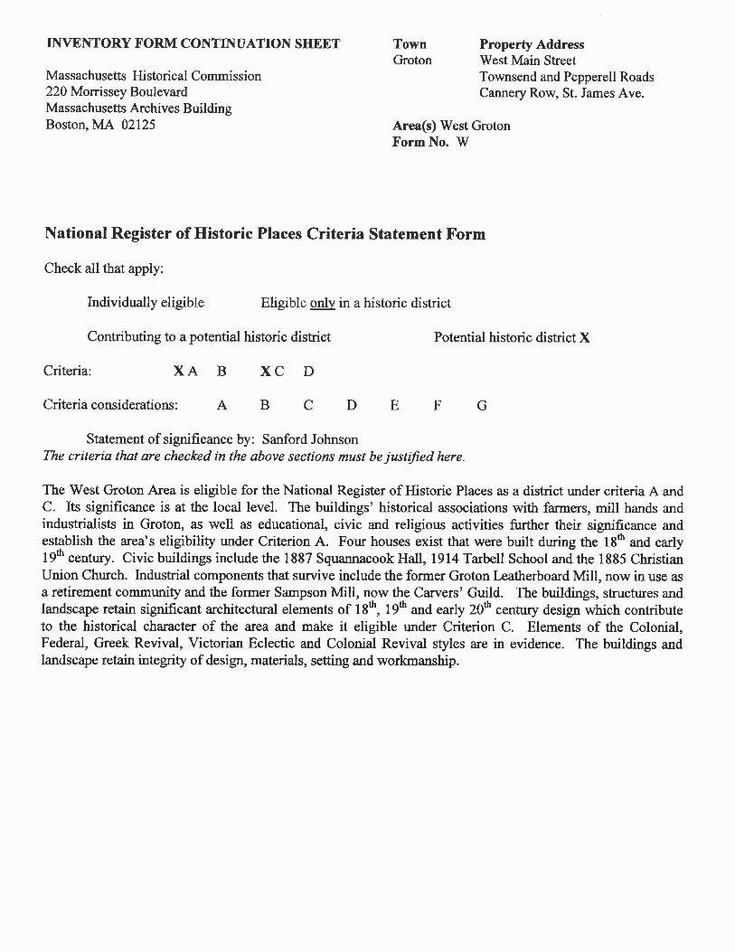
National Register of Historic Places Criteria Statement Form
Check all that apply:
Individually eligible Eligible only in a historic district
Contributing to a potential historic district Potential historic district X
Criteria: XA B XC D
Criteria considerations: A B C D E F G
Statement of significance by: Sanford JohnsonThe criteria that are checked in the above sections must be justified here.
The West Groton Area is eligible for the National Register of Historic Places as a district under criteria A andC. Its significance is at the local level. The buildings' historical associations with farmers, mill hands andindustrialists in Groton, as well as educational, civic and religious activities further their significance andestablish the area's eligibility under Criterion A. Four houses exist that were built during the 18th and early19th century. Civic buildings include the 1887 Squannacook Hall, 1914 Tarbell School and the 1885 ChristianUnion Church. Industrial components that survive include the former Groton Leatherboard Mill, now in use asa retirement community and the former Sampson Mill, now the Carvers' Guild. The buildings, structures andlandscape retain significant architectural elements of 18th
, 19th and early 20th century design which contributeto the historical character of the area and make it eligible under Criterion C. Elements of the Colonial,Federal, Greek Revival, Victorian Eclectic and Colonial Revival styles are in evidence. The buildings andlandscape retain integrity of design, materials, setting and workmanship.

Area(s) West GrotonForm No. W
INVENTORY FORM CONTINUATION SHEET
Massachusetts Historical Commission220 Morrissey BoulevardMassachusetts Archives BuildingBoston, MA 02125
Photos
TownGroton
Property AddressWest Main StreetTownsend and Pepperell RoadsCannery Row, St. James Ave.
16 West Main Street
16 West Main Street

Area(s) West GrotonForm No. W
INVENTORY FORM CONTINUATION SHEET
Massachusetts Historical Commission220 Morrissey BoulevardMassachusetts Archives BuildingBoston, MA 02125
Photos
TownGroton
Property AddressWest Main StreetTownsend and Pepperell RoadsCannery Row, St. James Ave.
94 West Main Street
6 West Main Street

Area(s) West GrotonFormNo. W
INVENTORY FORM CONTINUATION SHEET
Massachusetts Historical Commission220 Morrissey BoulevardMassachusetts Archives BuildingBoston, MA 02125
TownGroton
Property AddressWest Main StreetTownsend and Pepperell RoadsCannery Row, St. James Ave.
13 West Main StreetI
iI
25, 29 West Main Street

Area(s) West GrotonForm No. W
INVENTORY FORM CONTINUATION SHEET
Massachusetts Historical Commission220 Morrissey BoulevardMassachusetts Archives BuildingBoston, MA 02125
TownGroton
Property AddressWest Main StreetTownsend and Pepperell RoadsCannery Row, St. James Ave.
65 West Main Street
74 West Main Street

Area(s) West GrotonForm No. W
INVENTORY FORM CONTINUATION SHEET
Massachusetts Historical Commission220 Morrissey BoulevardMassachusetts Archives BuildingBoston, MA 02125
TownGroton
Property AddressWest Main StreetTownsend and Pepperell RoadsCannery Row, St. James Ave.
8 West Main Street
I •
8 West Main Street

Area(s) West GrotonFormNo. W
INVENTORY FORM CONTINUATION SHEET
Massachusetts Historical Commission220 Morrissey BoulevardMassachusetts Archives BuildingBoston, MA 02125
TownGroton
Property AddressWest Main StreetTownsend and Pepperell RoadsCannery Row, St. James Ave.
33 West Main Street

Area(s) West GrotonFormNo. W
INVENTORY FORM CONTINUATION SHEET
Massachusetts Historical Commission220 Morrissey BoulevardMassachusetts Archives BuildingBoston, MA 02125
TownGroton
Property AddressWest Main StreetTownsend and Pepperell RoadsCannery Row, St. James Ave.
West Main Street, Pepperell and Townsend Roads

Area(s) West GrotonFormNo. W
INVENTORY FORM CONTINUATION SHEET
Massachusetts Historical Commission220 Morrissey BoulevardMassachusetts Archives BuildingBoston, MA 02125
TownGroton
Property AddressWest Main StreetTownsend and Pepperell RoadsCannery Row, St. James Ave.
64, 68 West Main Street
91-111 West Main Street
Area(s) West GrotonForm No. W
INVENTORY FORM CONTINUATION SHEET
Massachusetts Historical Commission220 Morrissey BoulevardMassachusetts Archives BuildingBoston, MA 02125
TownGroton
Property AddressWest Main StreetTownsend and Pepperell RoadsCannery Row, St. James Ave.
17 Pepperell Road
39 Pepperell Road
Area(s) West GrotonForm No. W
INVENTORY FORM CONTINUATION SHEET
Massachusetts Historical Commission220 Morrissey BoulevardMassachusetts Archives BuildingBoston, MA 02125
TownGroton
Property AddressWest Main StreetTownsend and Pepperell RoadsCannery Row, St. James Ave.
73 Pepperell Road
18 Pepperell Road

Area(s) West GrotonFormNo. W
INVENTORY FORM CONTINUATION SHEET
Massachusetts Historical Commission220 Morrissey BoulevardMassachusetts Archives BuildingBoston, MA 02125
TownGroton
Property AddressWest Main StreetTownsend and Pepperell RoadsCannery Row, S1. James Ave.
Sampson Mill, Cannery Row off Townsend Road
48,56,60 Townsend Road

Area(s) West GrotonForm No. W
INVENTORY FORM CONTINUATION SHEET
Massachusetts Historical Commission220 Morrissey BoulevardMassachusetts Archives BuildingBoston, MA 02125
TownGroton
Property AddressWest Main StreetTownsend and Pepperell RoadsCannery Row, 81. James Ave.
40,30,28 Townsend Road
iti1t~iI""-'..II' ._ I
f, • ~~:'i" '.
,'. 'T. ..