West Gate Tunnel Project EES - Hobsons Bay City … · under four key values that include ......
35
Directorate: Infrastructure and City Services Environmental Effects Statements Hobsons Bay City Council Submission – July 2017 West Gate Tunnel Project EES
Transcript of West Gate Tunnel Project EES - Hobsons Bay City … · under four key values that include ......

Directorate: Infrastructure and City Services Environmental Effects Statements Hobsons Bay City Council Submission – July 2017
West Gate Tunnel Project EES

Acknowledgements
Council acknowledges all language groups of the Kulin Nation as the traditional owners of
these municipal land. We recognise the first people’s relationship to this land and offer our
respect to their elders past and present.
Council acknowledges the legal responsibility to comply with the Charter of Human Rights
and Responsibilities Act 2006 and the Equal Opportunity Act 2010. The Charter of Human
Rights and Responsibilities Act 2006 is designed to protect the fundamental rights and
freedoms of citizens. The Charter gives legal protection to 20 fundamental human rights
under four key values that include freedom, respect, equality and dignity.
For further information, or to receive a copy of this document in an alternate format, contact
Council on (03) 9932 1000.
Contents 1. Executive Summary.............................................................................................................. 5
1.1. Introduction .................................................................................................................... 5
1.2. Summary of key issues ................................................................................................ 5
1.2.1. Traffic and Transport ............................................................................................ 5
1.2.2. Human health and amenity .................................................................................. 6
1.2.3. Physical Environment ........................................................................................... 6
1.2.4. Community Impacts .............................................................................................. 7
1.2.5. Construction impacts ........................................................................................... 8
1.2.6. Planning Scheme Amendment (PSA) ................................................................ 8
1.3. Recommendation .......................................................................................................... 8
2. Introduction ............................................................................................................................ 9
2.1. Purpose of this submission ...................................................................................... 11
2.2. Consultation ................................................................................................................. 11
3. Key Submissions on the West Gate Tunnel Project .................................................... 15
3.1. Altona North/Brooklyn Precinct ............................................................................... 15
3.2. Spotswood / South Kingsville Precinct .................................................................. 17
3.3. Traffic and Transport .................................................................................................. 18
3.3.1. Traffic Volumes .................................................................................................... 18
3.3.2. Tolls and Truck Bans .......................................................................................... 19
3.3.3. Public Transport and Demand Management .................................................. 20
3.3.4. Cycling and Pedestrian Connections .............................................................. 20
3.4. Health and Amenity ..................................................................................................... 21
3.4.1. Noise ...................................................................................................................... 21
3.4.2. Air Quality ............................................................................................................. 22
3.5. Physical environment ................................................................................................. 23
3.5.1. Spoil Management ............................................................................................... 23
3.5.2. Surface Water / Drainage ................................................................................... 24
3.5.3. HBCC Infrastructure ............................................................................................ 25
3.5.4. Electricity assets ................................................................................................. 26
3.6. Community Impacts .................................................................................................... 26
3.6.1. Sportsgrounds and Open Space ...................................................................... 26
3.6.2. Donald W McLean Reserve and West Gate Golf Course ............................. 27
3.6.3. Noise Barriers....................................................................................................... 28
3.6.4. New park land at Precinct 15 ............................................................................. 29
3.6.5. Southern Portal .................................................................................................... 29
3.6.6. Landscape and Trees.......................................................................................... 30
3.6.7. Construction Impacts ......................................................................................... 32
4. Conclusion ........................................................................................................................... 34
5. Appendices .......................................................................................................................... 35
1. Executive Summary
1.1. Introduction
Hobsons Bay City Council acknowledges that The West Gate Tunnel Project is a key
transport infrastructure project that aims to improve transport capacity and performance of
Melbourne’s road network and supports future growth and planning for the western
metropolitan region in the short to medium term. HBCC supports a more integrated transport
and land use planning approach in addressing the long term transport demands in the
Melbourne’s west that includes significant investment in public transport, active transport
and travel demand management measures.
It is also acknowledged that the project will have significant and broad impacts on the
municipality and communities along its alignment. HBCC will continue to work with the
Western Distributor Authority (WDA) and Transurban to minimise and manage these impacts
and to identify opportunities created by the project that support HBCC’s strategic objectives.
HBCC’s input into the EES Technical Reference Group, Community Liaison Group and the
Urban Design Reference Group has resulted in general HBCC support for the EES
approach.
Of the 26 specific items within Council’s adopted Hobsons Bay Position and
Recommendations for the West Gate Tunnel Project, five have been addressed within the
tender design, eleven have been partially addressed and ten have not been addressed. The
outstanding issues raised are contained in this submission and will require consideration by
the EES Inquiry and Advisory Committee and/or through the project design development and
construction management process. The key issues yet to be fully addressed pertain to
potential toll avoidance, truck bans, local traffic congestion; air and noise emissions; and
subsequent health impacts on the community.
A number of issues and concerns have been identified in the planning, development and
design of the project and are summarised below.
1.2. Summary of key issues
This submission highlights a range of matters for further consideration.
1.2.1. Traffic and Transport
The project creates a relatively high level of uncertainty and risk in regard to traffic impacts
on Hobsons Bay, particularly in regard to:
New truck tolls along the freeway and associated toll avoidance
24 hour truck bans proposed on existing truck routes north of the Freeway
resulting in displacement of truck traffic into Hobsons Bay and lack of mitigation
measures.
Continued congestion at the West Gate Freeway interchanges (little or no improvement) and no consideration of an additional north – south road link across the freeway.
The project scope does not include provision for additional ramps at Grieve
Parade or at Dohertys Road to improve north south connectivity to the M80 from
the Altona North industrial precinct.
Increased traffic on a number of arterial roads in Hobsons Bay (including significant truck traffic increase in Millers Road).
Operational and safety concerns at the Simcock Ave / Hyde Street intersection and along Douglas Pde.
Impacts from construction traffic on the Hobsons Bay network (haul routes, roadworks, detours, construction traffic).
Lack of information on likely frequency and impacts of tunnel closures during operation.
Lack of public transport improvements
Provision, quality and connection of shared use trails
Concern that the project lacks strategic alignment with a sustainable transport and integrated land use planning outcome for the west of Melbourne.
1.2.2. Human health and amenity
The project cumulative impact on public health, particularly west of Melbourne Road,
Spotswood and west of Millers Rd, Brooklyn is a concern.
Traffic noise from the Freeway and along connecting arterial roads is a major problem for
residents and users of the open space. Air and noise pollution are already at health risk
levels in Brooklyn, Altona North, South Kingsville and Spotswood.
Despite the improvements to the extent of noise walls in the project, noise impacts remain a
concern. Noise walls should be extended to provide noise mitigation along the full boundary
of the Precinct 15 urban renewal site and the Hyde Street Reserve and Stony Creek
Reserve open space areas. The project should also mitigate noise impacts along residential
roads where traffic will increase as a result of the project.
HBCC supports the Spotswood/South Kingsville Residents Group and the Brooklyn
Residents Action Group and their concerns about worsening air quality impacts on
community health resulting from the project and inducing additional traffic into the area.
Specific concerns relate to the Project’s lack of monitoring ultrafine air particles and that a
filtration system should be included in the tunnel portal ventilation design.
Further evaluation of the air quality assessment should be undertaken, particularly in regard
to particulate matter from diesel vehicle emissions and impacts along the roads predicted to
have high truck traffic volumes.
1.2.3. Physical Environment
1.2.3.1. Vegetation
The project will remove almost all of the existing vegetation along the freeway corridor within
the work zone. While the commitment to undertake significant replacement planting is
acknowledged, this will take many years to establish. Consultation with HBCC will be
required to identify locations, species selection, and timing of planting, maintenance periods
and ongoing responsibilities.

1.2.3.2. Open space and Sports Grounds
The full impacts on sports clubs and other user groups, infrastructure and facilities is not yet
clear and further detail is sought.
Community requests, supported by Hobsons Bay Council and LeadWest, have also been
made for the Project to convert some of the existing privately owned land along Simcock
Avenue to public open space with links to the Stony Creek Reserve and to Scienceworks
Museum and the Coastal Trail.
An opportunity exists through the project for the improvement and management of
surplus/remnant land along the Freeway corridor (proposed and existing) and this should be
determined in consultation with HBCC
1.2.3.3. Water treatment and management
Details on the treatment and management of surface water, drainage and wastewater are
not yet clearly defined in the following areas:
Discharge into Kororoit Creek.
Management of water pumped for the tunnel works
Water treatment and reuse schemes and systems.
Impacts to public open space during construction and proposed permanent schemes.
Flooding risks and mitigation measures.
Drainage scheme capacities and interconnections
Council seeks the incorporation of water sensitive design and construction, including water
harvesting for roadside landscaping, open space and recreation sports ground irrigation.
1.2.3.4. Power lines
The full impacts of modification to the electricity assets, e.g. relocation of the 220KV towers
and undergrounding of the 66KV lines in Brooklyn, Altona North and Spotswood are not well
defined. HBCC believes an opportunity exists to underground more of the power lines to
improve visual amenity and create improved functionality/use of the land.
1.2.4. Community Impacts
Traffic congestion, access restrictions, tolls and land acquisitions will impact businesses and
have an economic impact within Hobsons Bay.
HBCC requires adequate protection of a number of heritage features:
Melbourne Glass Bottle Works amenities building on Simcock Avenue
Bluestone bridge over Kororoit Creek
Brooklyn Pump station on Millers Road
West Gate memorial on Hyde Street.
The final EES and project plan should include positive procurement policies within contracts
for supplies, services, training and employment that deliver positive social benefits to
Melbourne’s west.

1.2.5. Construction impacts
HBCC seeks adequate mitigating of construction impacts of traffic, dust, noise and vibration
and general visual and amenity impacts (considering all concurrent state and HBCC
projects). Construction compounds and haul routes will impact adjacent land users and must
be effectively mitigated.
Construction noise is likely to be high along the corridor. Concerns remain about permissible
noise levels during construction (particularly night time) potentially impacting residents’ sleep
and general wellbeing.
HBCC seeks that public transport improvements and priority is provided during project
construction and also minimal disruption and impact to pedestrians and cyclists.
1.2.6. Planning Scheme Amendment (PSA)
Planning Approval is proposed to be in the form of an Incorporated Document to facilitate
construction and delivery of the project.
The PSA seeks to introduce new controls into the Hobsons Bay Planning Scheme in the
form of a Design Development Overlay (DDO) to protect the WGT Project infrastructure,
particularly the tunnel component from impacts to the project from the development of
adjacent land.
The Minister for Planning will be the Authority for the project.
This approach is broadly supported by HBCC.
The Environmental Performance Requirements (EPR’s) should be included in the Planning
Scheme Amendment. Any works, including preparatory works, which are subject to the EES
assessment process must be carried out in accordance with the EPRs. Works cannot
commence until these are approved by the Minister.
1.3. Recommendation
Hobsons Bay City Council requests that the Inquiry require the Western Distributor Authority
to revise the EES to take into account the matters raised in this submission and recommend
to the Minister for Planning that the project be changed in accordance with this submission.

2. Introduction
The WGT Project is a declared project under the Major Projects Transport Facilitation Act
2009 (Vic). Under this Act the Minister for Planning is required to give planning approval for
the proposal which the Western Distributor Authority (WDA) is proposing in its Tender
Design following the process of public consultation set out in the Act. Accordingly the
Minister has appointed an Inquiry and Assessment Committee to advise him on the WDA’s
Design for the proposed WGT Project and to consider submissions from the public on the
WDA’s Environmental Effects Statement (EES) about their Tender Design. This is the
Hobsons Bay City Council’s submission to the WGT Project Assessment Committee in
response to WDA’s EES which was released for public exhibition on 29 May 2017. In the
course of the developing its submission HBCC received a large number of submissions from
the public about the proposed WGT Project. These have been used to inform this
submission and a summary is appended to this submission.
The West Gate Tunnel project objectives are to:
1. Improve transport performance in the M1 corridor
To support the increased travel demand generated by future population and
economic growth trends
To enhance connectivity between economic clusters
To enhance safety along the M1 corridor
To enhance access to jobs and services
2. Reduce reliance on the West Gate Bridge
To improve network resilience and redundancy
To mitigate strategic risks to the State and national economies
To improve travel reliability
3. Improve freight access to the Port of Melbourne and greater Melbourne
To improve reliability of access to the Port of Melbourne and on the freight
network
To support the travel demands arising from the future freight task
To enhance state and national competitiveness through freight productivity
Improvements
4. Improve community amenity on local streets in the inner west
To reduce freight on local streets
To improve safety on local streets.
The primary objectives of this submission are to assist the IAC to assess the EES in
accordance with the Major Transport Projects Facilitation Act, to consider the alignment,
design and performance requirements for the project and to make recommendations for
appropriate conditions. The second objective is to ensure the Committee fully appreciates
the impact that the proposed project will have on the community who live, work and play in
the city and on the HBCC’s assets and operations and future planning for the municipality.
The Incorporated Document that forms part of the Planning Scheme Amendment and the
conditions in the Environmental Management Framework should be strengthened and
tightened to ensure that delivery of the project to the highest standards is ensured.
The West Gate Freeway component would include upgrade and widening works between
the M80 Ring Road interchange and Williamstown Road, providing two additional lanes
in each direction to generally increase capacity to six through lanes in each direction (and
auxiliary lanes as required). The six lanes would be configured as two sets of three lanes in
each direction. The outer three lanes would provide access at all existing connections to the
West Gate Freeway and link to the tunnels under Yarraville. The inner three lanes would
provide express lanes between the M80 Ring Road and the West Gate Bridge. Elevated
ramps would provide a new connection between the West Gate Freeway and Hyde Street.
HBC’s involvement with the Technical Reference Group for the project has enabled the early
incorporation and response to relevant strategies and policies and the early identification of
key issues.
This submission includes an assessment of the impacts of the project on Hobsons Bay,
consideration of the design options and recommendations that seek to minimise impacts on
the municipality and that maximise benefits.
The Planning Scheme Amendment seeks to include an Incorporated Document into the
relevant Planning Schemes to provide the necessary planning approvals under the Planning
and Environment Act for the project.
There are five themes within the EES, which include:
Traffic and transport– Including detailed traffic modelling both with and without the
West Gate Tunnel
Physical environment– Including contaminated soil and spoil management,
groundwater, ground movement, surface water and ecology\
Human health and amenity– Including air quality, noise and vibration (surface),
vibration and regenerated noise (tunnel), and human health
Community– Including land use planning, social, business, landscape and visual
amenity
Heritage– Including Aboriginal heritage and historical heritage
In April 2016 Transurban released the concept plan for the Western Distributor Project (the
Project) showing the widening of the West Gate Freeway and options for a long and short
tunnel to Yarraville and ramps to Hyde Street Yarraville.
At the Ordinary Council Meeting on 14 June 2016 Council endorsed the release of Hobsons
Bay City Council’s Interim Position on the Project for community feedback.
In July 2016 Transurban released the Reference Design to three tenderers and then a high
level version to the public. Following the release of the public information, Council received
an update on the 26 July 2016 on the degree to which this public information aligned with
Council’s position on the Western Distributor.
Council finalised its position on the Reference Design for the Project in August 2016 and
adopted the Hobsons Bay Project Requirements, Principles, Objectives and Performance
Measures for the Western Distributor Project. Refer to Appendix A.
The Principles are:
1. An efficient, integrated and sustainable transport network outcome
2. Positive livability, amenity and community wellbeing outcomes
3. An environmentally responsible project
4. A genuine commitment to consult with the community
5. A value for money outcome
6. Planning for future growth
2.1. Purpose of this submission
This submission provides a response to the EES, highlighting the potential impacts of the
project and proposed variations and the adequacy of the Environmental Performance
Framework, including Environmental Performance Requirements to manage potential
adverse impacts and to support the realisation of the opportunities provided by the project.
The proposed Planning Scheme Amendment has been addressed separately within this
submission.
This submission is informed by HBCC’s policy documents and strategies. These include:
Integrated Transport Plan (Draft) 2017
Open Space Strategy
Heritage Strategy
Road Safety Plan 2013–17
Bicycle Plan
Urban Forest Strategy
Council Plan 2013–17
Municipal Strategic Statement within the Hobsons Bay Planning Scheme
Biodiversity Strategy (2017)
Aboriginal Heritage Action Plan
Business and Retail Strategy
Climate Change Adaptation Strategy
This submission is also informed by the requirements of the Environmental Effects Act, the
Major Transport Projects Facilitation Act and the Planning and Environment Act (1987)
2.2. Consultation
HBCC has been active in informing its community on the project since government’s release
of the Transurban proposal for Western Distributor. Council’s website has provided links to
the Project webpage and notifications provided to 9,000 local residents and businesses
seeking comments on the project and Councils interim position.

In summary, 60 submissions were received by council during July and August, 2016
following the release of the Council’s Interim Position on the project reference design.
These submissions comprised:
16 emails
12 via the Participate portal
13 telephone discussions
9 meetings with representatives from local industry and community groups.
The key themes identified through the community consultation include:
Noise and pollution emission mitigation for local residents and community groups
accessing facilities and open space to ensure quality of life and public health.
Concerns for the impact to local traffic particularly in within the vicinity of Simcock
Avenue, Hudsons Road, Douglas Parade and Hyde Street Spotswood.
Increased traffic impacts particularly at the Grieve Parade, Melbourne and Millers
Road Interchanges including need to address existing issues of poor connectivity and
safety management for pedestrians and cyclists.
Loss of private and public open space as a result of the widening of the freeway and
installation of sound walls.
Industry viability and functionality as a result of the Simcock Avenue on-ramp.
An increase in truck traffic in residential streets as a result of toll avoidance.
Capacity improvements need to accommodate connectivity to and growth of public
transport.
A summary of the submissions is attached in Appendix B.
Three community information sessions were conducted by Council during the recent EES
exhibition period - in Brooklyn, Newport and Spotswood.
Comparison between Council’s adopted position and the EES
The Project information currently available has been assessed against Council’s adopted
position to ascertain what items have been included or addressed, partially addressed or not
included (refer Appendix C).
Of the 26 specific items within Council’s adopted Hobsons Bay Position and
Recommendations for the West Gate Tunnel Project, five have been addressed within the
tender design, eleven have been partially addressed and ten have not been addressed
and/or require continued advocacy and consideration through the design development
process. The key issues yet to be fully addressed pertain to truck bans, traffic movement
and congestion; air and noise emissions; and subsequent health impacts on the community.
Table 1 in Appendix C provides a comparison of each of Council’s recommendations for the
project in its adopted position against the EES Tender Design.
Council’s position addressed in EES
The tender design released on 2 April 2017 addresses a number of items that Council
included in the August 2016 Hobsons Bay Position and Recommendations Western
Distributor Project. Specifically these include:
the long tunnel option
the design and construction of Stage 1 of the Kororoit Creek Trail
completion of the Federation Trail including redevelopment of the section within
Hobsons Bay to improve surface quality
assurance that steps will be taken to mitigate the impacts associated with the Project
during construction to local residents, open space and the transport network
noise mitigation for the Project will have a noise level target below 63 dB(A) in
residential areas
ongoing viability of the Westgate Golf Course through minimal impact to their
facilities
minimal impact to open space and club facilities specifically for the Spotswood
Football Club and Spotswood Cricket Club based at Don McLean Reserve
maximising opportunities to improve and landscape vacant and/or remnant public
land adjacent to or in the vicinity of the Project
Council’s position partially addressed in EES
Items that appear to have been partially addressed or will have less impact with the tender
design include:
congestion at the existing freeway interchanges at Melbourne/Williamstown Road,
Millers Road and Grieve Parade with some improved capacity
enhanced cycling and pedestrian connections particularly at the interchanges and a
grade separation of Federation Trail at Hyde street
the need for durable, high quality, attractive and effective sound walls, barriers and
lighting to protect the amenity of residents, open space, facilities and future
residential development sites
loss of amenity for local residents along the Project corridor
mitigation of pollution emissions, noise and loss of open space or facilities for the
Emma MacLean Kindergarten
loss to existing open space and functionality specifically the Stony Creek Reserve,
The Avenue Reserve, Lynch Road Reserve and WLJ Crofts Reserve
vegetation replacement and tree canopy impacts
Social procurement provisions that strengthen the local economy through the
creation of local jobs and sourcing of services and goods from local businesses.
Council’s position not addressed in EES
Unresolved items include:
mitigation of adverse traffic impacts on Hobsons Bay through toll and truck ban
avoidance

implementation of truck bans on Blackshaws Road, Hudsons Road, High Street,
Mason Street and Kororoit Creek Road (east of Millers Road) with the purpose to
mitigate toll avoidance in the truck only tolled section of the Westgate Freeway from
Grieve Parade to Melbourne/Williamstown Road (local businesses with a destination
point within these areas would be exempt from these truck bans)
reconsider the use of Simcock Avenue as access to the freeway entry ramp from
Hyde Street given the significant potential access and egress issues for current
business and including the potential for traffic conflict with on-ramp traffic
exemption on trucks travelling to and from the Spotswood Industrial Precinct, from
the proposed Francis Street truck ban so that they can continue to access the
freeway ramps at Williamstown Road
freeway access ramps at the intersection of Dohertys Road
traffic congestion on Hyde Street and Douglas Parade
additional north south road connection across the freeway to relieve pressure on
existing routes
significantly improving public transport outcomes
incorporation of water sensitive design and construction, including water harvesting
for roadside landscaping, open space and recreation sports ground irrigation
Two items regarding the undergrounding of 220KV power lines and the locating of both
ramps north of the West Gate Freeway have not been included in the tender design. It is
noted that the tender design includes the conversion of some of the existing power pylons to
monopoles which have a reduced footprint.
There are numerous implications from the West Gate Tunnel tender design for Precinct 15.
In summary these relate to the connectivity for pedestrians and cyclists to access the
Federation Trail, public open space and sound attenuation.
The key impacts identified by the Project for various sites along the West Gate Freeway
component include temporary traffic noise, visual, open space, tree removal and minor loss
of land and are described in Chapter 16.1, Volume 2 of the EES.
3. Key Submissions on the West Gate Tunnel Project
Unresolved matters that specifically impact Hobsons Bay that are the focus of HBCC’s
submission to the EES are under the following headings:
1. Altona North/Brooklyn Industrial Precinct
2. Spotswood/South Kingsville Precinct
3. Traffic and transport
4. Physical environment– Including contaminated soil and spoil management,
groundwater, ground movement, surface water and ecology
5. Human health and amenity– Including air quality, noise and vibration (surface), and
human health
6. Community– Including land use planning, heritage, social, business, landscape,
urban design and visual amenity
7. Construction Impacts
3.1. Altona North/Brooklyn Precinct
Residents of Brooklyn near Millers Road have experienced the worst air quality and dust
pollution in Melbourne for many years (8th worst air pollution hotspot in Australia according
to the Environment Justice Australia – “Clearing the Air” report 2014).
Council and VicRoads recently completed the Cumulative Impacts Assessment that
identified the Millers Road/WGF interchange as a major congestion point due largely to the
traffic generated from large developments in the area such as that proposed in Precinct 15
on Blackshaws Road. The predicted increase in trucks and cars from the WGT Project will
make this much worse. The 3 fold increase in truck traffic predicted in Millers Road by 2031
will further exacerbate traffic congestion, increasing travel delays for business and residents
and likely result in rat running through local streets and poorer safety. Also concerns exist
about the difficulty for cyclists and pedestrians in Millers Road crossing the Freeway at the
interchange to access open space, community and sporting facilities and the Altona Gate
Shopping Centre. This problem will be exacerbated by the Freeway widening works and
increased traffic volumes proposed with the West Gate Tunnel project. Other problems faced
by the residents include the relentless traffic noise both day and night, lack of high quality
open space and poor amenity, being surrounded by heavy truck routes and industry.
The introduction of truck bans will likely divert thousands of trucks into Millers Road and
Hobsons Bay via two key north south routes - Paramount Road/Tottenham Parade/Geelong
Road and Market Road/McDonald Road that are currently used by many of the trucks
accessing container parks and warehouses with destinations in or around the Port.
Alternative suggestions to Millers Road would be diverting these trucks south along Geelong
Road to Grieve Parade or construct an extension of Tottenham Parade/Cemetery Road into
Hardie Road/Cawley Road with a new connection to the Freeway. The Grieve Parade option
is the obvious and easiest alternative and would not impact on residents, however it would
involve trucks doubling back about 2km. It would also require capacity upgrades at the on
and off ramps at the West Gate Freeway interchange.
Council has been working with VicRoads to encourage truck traffic to use Grieve Parade (an
industrial precinct) rather than Millers Road. Millers Road traverses residential areas, activity
centres and school zones.
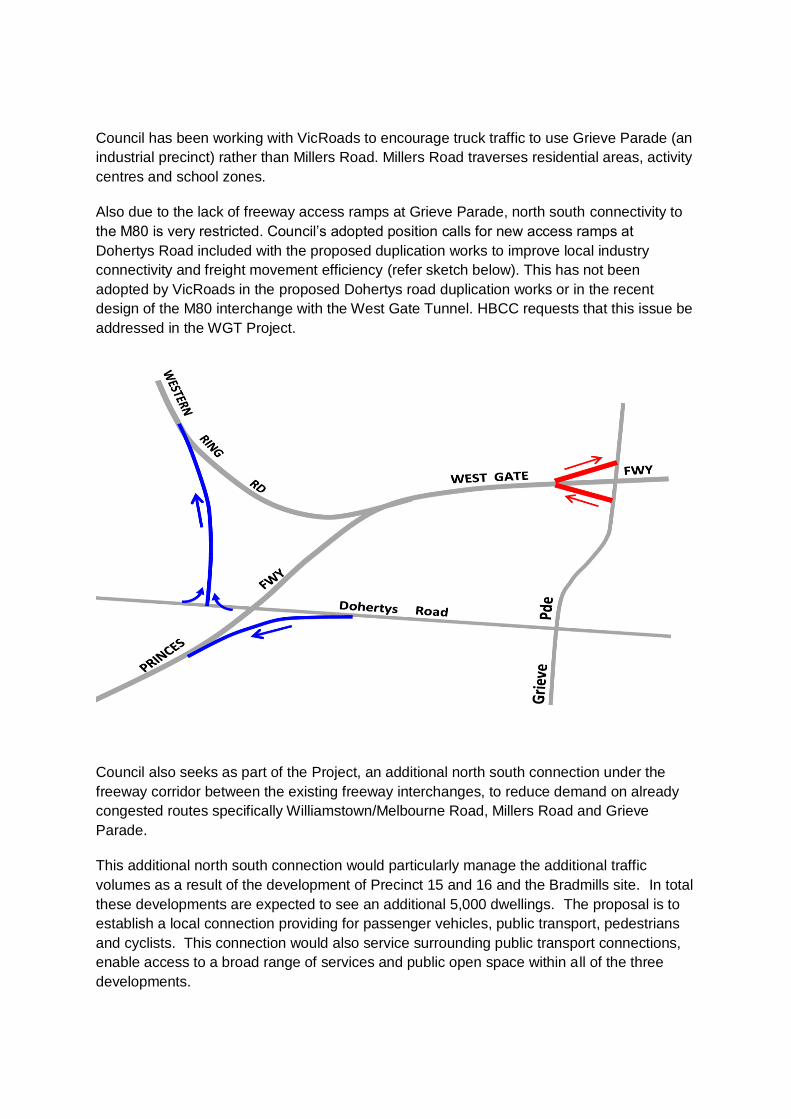
Also due to the lack of freeway access ramps at Grieve Parade, north south connectivity to
the M80 is very restricted. Council’s adopted position calls for new access ramps at
Dohertys Road included with the proposed duplication works to improve local industry
connectivity and freight movement efficiency (refer sketch below). This has not been
adopted by VicRoads in the proposed Dohertys road duplication works or in the recent
design of the M80 interchange with the West Gate Tunnel. HBCC requests that this issue be
addressed in the WGT Project.
Council also seeks as part of the Project, an additional north south connection under the
freeway corridor between the existing freeway interchanges, to reduce demand on already
congested routes specifically Williamstown/Melbourne Road, Millers Road and Grieve
Parade.
This additional north south connection would particularly manage the additional traffic
volumes as a result of the development of Precinct 15 and 16 and the Bradmills site. In total
these developments are expected to see an additional 5,000 dwellings. The proposal is to
establish a local connection providing for passenger vehicles, public transport, pedestrians
and cyclists. This connection would also service surrounding public transport connections,
enable access to a broad range of services and public open space within all of the three
developments.
Residents in the Beevers Street area (located east of Millers Road and immediately south of
the Freeway) have only one access/egress (to Millers Road) and due to the proximity to the
freeway off ramp and associated congestion and can be very difficult for residents and
emergency vehicles accessing properties. HBCC requests provision of a shared path
through the disused land along the edge of the Freeway and connecting the state
government land to the west of Beevers Street (that could also be used for emergency
vehicle access). Also concerns exist about the difficulty for cyclists and pedestrians in Millers
Road crossing the Freeway at the interchange to access open space, community and
sporting facilities and the Altona Gate shopping Centre. This problem will be exacerbated by
the Freeway widening works and increased traffic volumes proposed with the West Gate
Tunnel project.
A number of remnant VicTrack and VicRoads land parcels exist along the Freeway that are
unattractive, fenced off and not well maintained, e.g. Beevers Street freeway reserve.
Resident would like this land improved and where possible opened up for public use,
including the land leased by the Italian Club to improve local accessibility in the area.
A number of mature trees along the southern edge of the freeway provide significant amenity
and should be retained where possible or offset with suitable semi mature trees.
3.2. Spotswood / South Kingsville Precinct
HBCC has concerns about the WGT west bound entry ramp location due to:
Impact on the industrial land and Don McLean Reserve
Noise impacts on local residents
Use of Simcock Avenue and Stephen Street as access roads to the west bound ramp
Safety issues at the Douglas Parade intersection due to poor sight lines.
Refer to Appendix E.
Concerns also exist in regard to the traffic impact on Douglas Parade and Hyde Street. The
ramps and associated signalisation will create localised congestion with the combined ramps
carrying up to 5000 vehicles a day in 2031 including nearly 2000 trucks. Traffic in Hyde
Street (between Francis Street and the freeway) is expected to increase from 15,000 to
22,000 vehicles per day in 2031, including an extra 1850 trucks per day (from 1450 to 3300).
It is suggested that design changes will be required to address this undesirable issue of
freeway access from the local street network, e.g. intersection treatments, parking and local
access consideration and truck curfews should be introduced in Spotswood to protect the
local area from traffic short cutting through the area.
East bound trucks from the Spotswood industrial area will be required to travel via
Hyde/Francis/Whitehall Streets and Footscray Road to the Bolte Bridge due to 24 hour truck
bans in Francis Street. Council seeks as a part of the Project, to exempt trucks travelling to
and from the Spotswood Industrial Precinct from the proposed Francis Street truck ban, so
that they can continue to access the freeway ramps at Melbourne/Williamstown Road. There
are few east/west connections for trucks servicing the Spotswood industrial area to access
the Westgate Bridge to travel east. With proposed truck bans to the north of the freeway the

closest east /west roads are Hudsons Road through the Spotswood activity centre and North
Road, a residential road located approximately one kilometre south of the industrial precinct.
It is acknowledged that a number of EPR’s exist to reduce impacts on this area, however the
proposed construction compound at the northern end of Hall Street, Spotswood and the use
of Hall street as a construction traffic route, is not supported due to the environmental,
amenity and visual impacts on the Emma McLean Kindergarten.
Following community requests, HBCC recommends that State Government purchase some
existing privately owned land along Simcock Avenue (south of the West Gate Freeway) and
convert this land to public open space with links to the Stony Creek Reserve and to
Scienceworks Museum. This would leave a lasting legacy to the Spotswood community and
assist in offsetting the negative impacts on the local community resulting from the West Gate
Tunnel Project.
3.3. Traffic and Transport
3.3.1. Traffic Volumes
The project is predicted to induce an additional 37,000 vehicles per day onto the West Gate
Freeway between Millers Road and Melbourne Road in 2031 (compared to no WGT project).
New tolls along the freeway, in the tunnels and on the Hyde street ramps combined with the
introduction of a total truck ban on existing truck routes to the north of Hobsons Bay create a
high level of uncertainty in regard to traffic impacts on the Hobsons Bay community.
The WGT traffic impact assessment has been updated, with some slight increases in
general traffic in some areas but major increases in trucks in Millers Road north of the
freeway (up to 15,000 trucks/day in 2031).
Table 2 shows the predicted changes in daily traffic numbers and truck numbers in 2031
from the WGT project traffic modelling report for the EES on roads close to the Freeway
compared to if the project did not proceed.
Table 2: Differences in traffic volumes between the project and no project in 2031
Location
Change in daily traffic numbers in 2031 due to project
Change in daily truck traffic numbers in 2031 due to project
Millers Road (north of Freeway) + 4500 + 7000
Millers Road (south of Freeway) + 600 + 800
Melbourne Road + 800 + 100
Hyde Street + 1500 + 1500
Douglas Parade 0 + 700
Simcock Avenue + 1500 + 800
Blackshaws Road (east of Millers Road)* + 600 - 900
Blackshaws Road (west of Millers Road)*
- 400 + 700
Hudsons Road* - 200 - 300
Grieve Parade (south of Freeway) + 600 - 600
* The modelling for the EES assumes that traffic measures (unspecified) will be in place to
reduce the number of trucks using these roads. Council seeks clarification on what
measures are proposed and how their effectiveness has been evaluated.
The high predicted increase in the volume of trucks in Millers Road north of the freeway
reflects impacts from the toll avoidance of the first tolling station near Grieve Parade and
truck bans in Francis Street, Somerville Road, Moore Street and Buckley Street.
3.3.2. Tolls and Truck Bans
As shown above, new tolls along the freeway, in the tunnels and on the Hyde street ramps
combined with the introduction of a total truck ban (in conjunction with the project) on
existing truck routes to the north of Hobsons Bay are expected to direct more traffic,
particularly trucks, on to some roads in Hobsons Bay.
The WGT Project will impact the existing traffic and truck movements across a much larger
area of Hobsons Bay than that modelled and it is suggested that a broader assessment of
traffic impacts be undertaken by the WDA and VicRoads in consultation with Council. For
example Kororoit Creek Road, Blackshaws Road, Mason Street and North Road are all likely
to experience higher traffic volumes resulting from toll avoidance and avoiding truck bans.
Due to the high level of uncertainty and risk in regard to traffic impacts on Hobsons Bay,
particularly with the new truck tolls along the freeway and 24 hour truck bans proposed on
existing truck routes north of the Freeway, it is recommended that truck bans and curfews be
introduced on a number of roads within Hobsons Bay to protect residential amenity.
Council, in its adopted position; calls for truck bans on all of Blackshaws Road, Hudsons
Road, North Road, High Street, Mason Street and Kororoit Creek Road east of Millers Road.
Also a night and weekend truck curfew introduced in Millers Road between Kororoit Creek
Road and Geelong Road as part of the Project. Noting that local businesses with an
origin/destination point within these areas would be exempt from these truck bans. Refer to
Appendix F.
The tolling price structure will have a major impact on the attractiveness and use of the WGT
Project to achieve the projects desired objectives and reduce the likelihood of toll avoidance
and traffic seeking alternative routes through Hobsons Bay. HBCC believes that tolls should
be carefully monitored and adjusted as necessary to optimise the WGT Project. This should
include toll capping along the West Gate Freeway section and time of day variable tolls to
incentivise traffic off roads in residential areas and tolls on the Hyde street ramps set to
restrict the ramps being used by general traffic to avoid the tunnel tolls.
The EES suggests storage requirements on the entry ramps cannot be achieved. This raises
questions on capacity and will likely result in increased congestion and delays. It is proposed
that capacity constraints at localised locations will be solved by distributing traffic across
adjacent ramps if forecast demands are realized and as this is outside the project, works
would need to be undertaken by VicRoads, under a complimentary project to resolve the
issue. This is not satisfactory to Council and should be resolved and the impacts mitigated
under the WGT Project.

Milers Road exit ramps are proposed to be shortened (westbound by 110m). Given that this
ramp currently has queues back to the freeway during AM peaks and the increased demand
that will result from the new truck bans, questions are raised as to its capacity, performance
and safety. HBCC does not believe that the traffic impact assessment has adequately
addressed entry and exit ramp performance and capacity.
3.3.3. Public Transport and Demand Management
Council believes that this project provides a significant opportunity to help to reduce traffic
congestion through travel demand management and improved on road public transport
priority measures during construction and operation of the project.
The failure of the project to significantly enhance public transport opportunities and
outcomes along the corridor is considered a key shortcoming in the project. HBCC has
called for dedicated bus lanes and priority measures to assist bus operations and services.
In addition transit lanes should be provided to encourage multi-occupant passenger vehicles
on the freeway.
Also public transport should be prioritised/augmented during construction to assist managing
traffic capacity/performance along the project corridor.
3.3.4. Cycling and Pedestrian Connections
The Tender Design contains a number of cycling and pedestrian upgrades and
improvements. Details for the connections to the existing network (including on road cycle
paths) requires clarification to ensure that safe and effective connections are made to a high
standard. For example a grade separation of Federation Trail at Hyde Street with a
seamless connection to the Coastal Bay Trail would provide a safer and more efficient
outcome and should be included in the project. This should also include an upgrade of the
shared use path between the end of Federation Trail and the West Gate bike punt to assist
and improve the option for users to cross the river via the punt to access the Fishermans
Bend precinct, thus significantly reducing the travel time and distance.
Details on the Kororoit Creek Trail, including land acquisition and trail specifications are not
clear and HBCC seeks consistency with Stages 2 and 3 (currently being constructed by
Council).
Hobsons Bay seeks that the proposed upgrade of Federation Trail west of Millers Road to be
a full reconstruction in concrete rather than a resurface of the existing asphalt treatment to
provide a more durable and long lasting shared use path (SUP).
Cyclists and pedestrians using Millers Road and Melbourne Road at the Freeway
interchange already experience delays and very poor amenity will be further impacted by this
project due to the additional lanes to cross and predicted increased road traffic. While
acknowledging the proposed widening of a short section of path under the freeway
overpass, connections onto the existing network are not well defined in the project. Also
pedestrians deal with the constant problem of trucks and cars queuing over pedestrian
crossings.
The proposed SUP under the Freeway at New Street on the east side of Precinct 15 does
not connect well into the existing network. HBCC requests that a connection to Edwards
Reserve, South Kingsville should be included.
Traffic Management Liaison Group
The EPR requires that a Traffic Management Liaison Group is to be established and to
include representatives from agencies nominated by the State. The EPR should be
amended to include local government representatives. Also this Group must be convened
prior to the commencement of any works impacting on road, paths or public transport
infrastructure.
Further details on traffic impacts on HBCC will be provided at the Inquiry Hearings.
3.4. Health and Amenity
3.4.1. Noise
Noise pollution is an underrated environmental issue that affects many people and takes a
toll on human health, in both physiological and psychological ways, disturbing sleep, rest,
study and communication. Qualitative and Quantitative measurements should be applied to
the project considering the impacts on human populations and the long term implications for
human health and wellbeing.
Despite the improvements to the extent of noise walls in the project, noise impacts remain a
concern. Construction noise is likely to be high along the corridor. Concerns remain about
permissible noise levels during construction (particularly night time) and maximum noise
levels at night during operation of the WGT potentially impacting residents sleep and general
wellbeing. Also noise walls should be provided along the full boundary of the Precinct 15 site
and the Hyde Street Reserve and Stony Creek Reserve open space areas.
The project has been designed to meet VicRoads policy on traffic noise which does not
require the protection of open recreational space or proposed urban renewal areas. The
policy sets an external noise limit of 63 dB LA10 (18h) for new roads to protect the inside of
noise sensitive buildings. World Health Organisation (WHO) guidelines identify that noise
levels of 55dB LAeq (16h) can create serious annoyance for people in outdoor areas and
50dB LAeq (16h) noise can create moderate annoyance. Noise levels near the freeway in
Hobsons Bay are predicted to be as high as 70 dB LAeq (18h). HBCC’s public realm of
parks, places and local streetscapes are very important urban areas for human health. Given
the amount of activity that occurs in Hobsons Bay’s parks, places and streets along the
freeway corridor, the noise impacts of the project need to be significantly reduced.
In 2015 VicRoads commenced a review process to update their traffic noise policy, including
a discussion paper and public and stakeholder consultation, with the objective to modernise
the policy and approach to road traffic noise in line with international trends. The report
should include some discussion with respect to the policy review or any potential
implications should it become enacted policy in the future.

It is stated that traffic generating an increase in noise greater than 2dB (A) would result in an
adverse response to sensitive receptors. It is noted that Millers Road north of WGF is
predicted to experience a 2.2 dB (A) increase and the report suggests limited sensitive
receptors in Millers Road. Council is concerned about the significant increase in truck traffic
expected to use this section of road (7000 extra trucks) which has residential properties
along one side.
The report has little reference to peak noise (Lmax), particularly at night time. It would be
useful to understand the spread and frequency of high night time peak noise levels as this is
a potential contributor to community health impacts through sleep deprivation. Whilst the
VicRoads Policy only requires assessment of L18hour (6am to Midnight), night time levels
should also be assessed (as they are in other jurisdictions).
Also, the EES has no reference to ongoing auditory and non-auditory and tonality noise
monitoring identified as Health issues in WHO publications
HBCC requests that temporary noise walls be erected prior to the demolition of existing
noise walls. This will provide protection from both operation and construction activities
associated with the project.
Further details on noise impacts on HBCC will be provided at the Inquiry Hearings.
3.4.2. Air Quality
Further evaluation of the air quality assessment will be required, particularly in regard to
particulate matter from diesel vehicle emissions, emissions from the ventilation shaft (and
the possible need to provide filtration), impacts along the roads predicted to have high truck
volumes and the need to consider ultrafine particles emitted from the project and impact on
public health. Council supports the Spotswood/South Kingsville Residents Group have
raised concerns about worsening air quality impacts on the community resulting from the
project. Specific concerns relate to the Project’s lack of monitoring ultrafine air particles
given the known public health impacts resulting from these harmful emissions.
The following issues are raised:
Lack of regard to any evidence/data published since 2012. The evidence used
throughout the report is not the most recent available.
One of the stated objectives of the report is to “facilitate more health conscious
planning” yet the report has failed to consider current world’s best practice mitigation
strategies such as tunnel filtration or pollution barriers. A cost benefit analysis
offsetting instalment against reduced health expenditure should be incorporated.
A number of appropriate health outcomes have been omitted including strokes,
respiratory ED admissions in children under 5, cognitive impairments, birth
outcomes, and diabetes. There are now (since 2012) meta-analyses that provide
risk estimates for these health endpoints.
The risk estimate used for lung cancer is too conservative when considering the full
body of available evidence (used risk estimates from 1996)

The population data used is not the most recent or best available
The health risks have been calculated on air quality data that is potentially outdated
Ground level ozone has been omitted entirely from the health report
No consideration given to ultrafine particles (it is understood that it’s not possible yet
to undertake a quantitative health analysis on ultrafine particles, however
precautionary principle should be used and some consideration given to these along
with discussion on mitigation strategies).
In tunnel air quality only considers CO and NO2 in terms of health.
The EES does not consider ‘road side asthma’ as it states there is no evidence
available on this to base any estimates on. There is evidence available on this, both
domestic and international.
While the EES states that Residents adjacent to Francis Street experience
improvements, residents adjacent Miller’s Road will have negative impacts from the
significant increase in truck traffic from the project.
An EPR should be included that establishes an Air Quality Community Consultative
Committee to review and provide advice on the location of the community based monitoring
stations; construction and operation environmental management plans, compliance tracking
reporting, audit reports or complaints and provide advice on dissemination of monitoring
results and other information on air quality issues.
Further details on air quality impacts on HBCC will be provided at the Inquiry Hearings.
3.5. Physical environment
3.5.1. Spoil Management
It is critical that the CEMP and the traffic management plans identify the locations of
appropriate landfill sites for the different types of spoil being removed (such as clean fill and
prescribed industrial waste), the transport routes to get to each of the landfill sites, and
transport guidelines to facilitate the safe transport of the spoil.
It is recommended that:
The EES should clearly identify where off-site remediation of Prescribed Industrial
Waste, Category A spoil will occur, and how the spoil will be transported there, stored
and treated.
The capacity of existing landfill sites in the north and west of Melbourne should be
based on approved capacity of these sites only, and should not rely on the capacity
of these sites which have not been approved.
The CEMPs for excavation, and transport management plans for the projects, should
be expanded to include:
o The identification of appropriately licensed landfill sites suitable for the
different classes of spoil;
o The identification of transport routes to each of these licenced landfill sites;
and
o Guidelines for the transportation of contaminated material to these landfill
sites.

It is noted that additional testing and monitoring will be required by the contractor in a
number of locations to ensure safe compliance with EPA requirements for earthworks, spoil
management, surface water, drainage and wastewater. Given works will be occurring
simultaneously along the Project corridor, this must be managed carefully to ensure
compliance.
The EES states that Compliance with best practice construction controls for managing
sediment, stormwater, spills and dewatering activities will be undertaken. However,
earthworks are not always undertaken to this standard, and often with insufficient
supervision and compliance enforcement. Polluted water run-off can have a significant
negative impact on downstream waterways and drainage lines, and in a project of this size
could be substantial. Given the location of the western exit portal it is critical that the surface
water management issues are well managed, monitored and controlled.
3.5.2. Surface Water / Drainage
One of the legacy opportunities that could be offered by the project is to deliver water
security for the open spaces, parks and gardens along the corridor.
While Council generally supports integrated water cycle solutions and the treatment of both
new and existing road runoff to best practice stormwater management in accordance with
BPEMG, other impacts such as reduction of functional open space and increased
responsibility on Council need to be considered and mitigated. Evidence of functional
schemes including shared responsibilities would need to be provided as a part of the further
consultation with Council on such proposals.
Drainage asset condition assessments must be completed for both before and after
construction works on Council owned drainage assets impacted by the Project. Any works
on these assets must comply with Council requirements. Defects or dilapidation
assessments will be required.
The document makes reference to a number of areas of increased flooding risk. The
proposed solutions to manage these risks should be provided to Council and the appropriate
authorities for comment and consideration. A co-ordinated approach across the relevant
authorities needs to be applied to ensure standards and expectations are managed without
assumption of ongoing maintenance responsibilities. Should potential flooding be identified,
a revision of the flooding overlays in the HBCC Planning Scheme will be required at the
Project’s cost.
It is noted that the drainage model does not factor in major infill development sites such as
Precinct 15 and 16 (ex Dons and Caltex sites) located south of the Freeway. This is seen as
a shortcoming in the design and may underestimate the drainage infrastructure capacity
required to meet future demand. The modelling should be reviewed to include all known
development sites.

3.5.3. HBCC Infrastructure
The EES has not adequately assessed the project’s impact on the HBCC’s road reserve
infrastructure. Pursuant to the Road Management Act 2004 HBCC is the Municipal Council
responsible as the Co-ordinating Road Authority for the management of municipal roads in
the municipal district. HBCC is also the Responsible Road Authority responsible for
management of the footpaths, nature strips and medians on arterial roads in the municipal
district. Works on municipal roads and footpaths, nature strips and medians on arterial roads
must be carried out in accordance with HBCC policies and engineering standards. The
EPR’s should recognise or address the HBCC in its capacity either as the Coordinating
Road Authority for municipal roads or as the Responsible Road Authority for road reserve
infrastructure on arterial roads. In addition, any municipal roads that are identified to require
local area traffic management treatments to protect the amenity of the local street network
impacted by increased traffic resulting from the WGT Project or traffic avoiding the WGT
Project tolls will require works to be undertaken which will impact on the road reserve
infrastructure in those municipal roads. These works should be recognised in the EES and
the costs of these road reserve infrastructure works should be borne by the Western
Distributor Authority. In general, Council’s road reserve infrastructure that is impacted at
these locations to varying degrees includes roadway, kerb and channel, footpath, drainage
network including drains, pits and open channels, traffic management devices, street
furniture and signage assets.
An EPR is required that includes conditions and performance requirements for HBCC roads,
drains, kerb and channels, footpaths, street lighting and nature strips:
1. All HBCC road reserve infrastructure impacted by the WGT Project must be
reconstructed/constructed in accordance with the Council’s Engineering design
standards. All road reserve infrastructure works must be carried out to the satisfaction of
HBCC
2. All altered portions of road (including the provision of footpaths, public lighting, street
trees, pavement marking and signage) must be constructed in accordance with plans
and specifications first approved by the HBCC.
3. All existing HBCC stormwater drainage system impacted by the WGT Project must be
upgraded for storms of up to 1 in 20 years ARI.
4. The contractor must demonstrate that the project will not increase flood levels and
frequency of flooding during construction and operation of the WGT Project. This
especially applies to the discharge of groundwater and stormwater run-off from the
Tunnel and Western Portal that is proposed to be discharged into the Council’s storm
water system.
5. Prior to the Commencement of construction, plans and specifications of all HBCC road
reserve infrastructure works and associated works must be submitted to and approved
by the HBCC
6. All public lighting must be unmetered and energy efficient.
7. On Completion of the project, HBCC will require digital (AutoCAD or GIS) and PDF
versions of all design and “as constructed” drawings on a USB as well as two hard
copies of these drawings for all Council infrastructure impacted by the project. An
inventory of as built asset data for items in the public domain shall be provided in a
Microsoft Excel spread sheet format. The data shall list all assets constructed as part of

the contract by location with quantities and construction costs for each asset under the
care and management of HBCC;
8. Operation and maintenance manuals for infrastructure in the public domain shall be of
sufficient detail to enable the works to be operated and maintained as intended in the
design.
3.5.4. Electricity assets
It is noted that the above ground 220kV electricity towers will be retained. Undergrounding
this infrastructure would bring significant amenity benefits to the area. Justification for the
retention of the towers above ground should be provided. The removal of this ‘benefit’
diminishes the acceptability of the overall impacts on Hobsons Bay.
3.6. Community Impacts
3.6.1. Sportsgrounds and Open Space
WLJ Crofts Reserve.
Hobsons Bay City Council has allocated funds in the 2017/2018 Annual Budget to undertake
a Masterplan study of the WLJ Crofts Reserve. As is generally acknowledged, the Reserve
is now in need of significant works to the playing fields, the pavilion and the cricket practice
wickets to make it “fit for future purpose”, improve amenity and minimise risks to users of the
facility. The Westgate Tunnel Project will impact the WLJ Crofts Reserve and as such
represents a significant factor in master planning considerations. HBCC requests that the
two projects be considered together and seeks to work with the Project Team, and tenant
clubs of the Reserve to get the best possible outcomes from the Masterplan for the WLJ
Crofts Reserve.
As identified in SR09, Table 14.1, Section 14.2.5 of the EES, “People use WLJ Crofts
Reserve less because increased noise and visual impact make it less attractive or suitable
for their activities”. HBCC believes that this is an important issue and should have a greater
“Residual risk rating” than the “Low” rating in the EES.
As stated in the EES, the WLJ Crofts Reserve is a heavily used sporting and passive open
space facility. The EES estimates that the change to the Reserve will be minimal as there
will only be a loss of a strip of land of 282m2 (0.3% of total area) at the northern edge of the
Reserve.
Whilst the area of land lost in the Reserve is small, the land lost is in an area that is very
critical to some activities within the reserve, particularly the Altona North Cricket Club as the
cricket practice wickets are located very close to the northern border of the Reserve. Based
on the information currently available it is considered that with the land lost, the construction
of new barriers and land temporarily used to build these barriers, and the planting of new
trees along the northern border of the Reserve will encroach upon the practice wickets and
have adverse short and long term impacts on cricket training activities. The practice wickets
are used four afternoons and nights per week, plus on Sunday mornings in the pre-season
by men and women and children. As part of the West Gate Tunnel Project and in

conjunction with the Masterplan for the Reserve, the practice wickets should be relocated to
a more appropriate area of the WLJ Crofts Reserve.
Since its establishment, there has been a considerable amount of vegetation planted at the
Reserve, now providing a pleasant environment for users of the Reserve. While it is of
concern that the mature vegetation along the northern side of the Reserve will be removed
during the construction phase of the project the replanting program presents a real
opportunity to vastly improve the landscape of the Reserve, not just the northern edge.
Significant tree planting should be undertaken in appropriate locations throughout the whole
Reserve consistent with the new Masterplan. To minimise noise and improve amenity, the
landscaping and tree planting should be undertaken as early as possible after project
commencement.
3.6.2. Donald W McLean Reserve
It is acknowledged that the project will have relatively low impact on the open space and
sports clubs based at Don McLean Reserve (Spotswood Football Club and Spotswood
Cricket Club) however the project may result in the need to relocate some or all of the cricket
nets. If this is required consultation with HBCC and the clubs will be required, and may
require a review of the current masterplan for the reserve. Refer to Appendix G.
HBCC seeks further details on the proposed multi-purpose club rooms to accommodate the
sporting clubs and golf club. The facility is required to meet HBCC and tenant requirements
and must be compatible with the Don McLean Reserve Masterplan. A detailed EPR should
be developed that commits the contractor to the standards and quality required.
HBCC notes the EPR’s relating to mitigating the construction impacts in this area and
expects a high level of monitoring and auditing of EPR compliance by the contractor in this
highly used and sensitive area.
West Gate Public Golf Course
Westgate Golf Course is a short course on about as small a parcel of land is as practical for
golf. The WGT Project presents a significant risk to the ongoing viability of the golf club.
It is understood that the golf course will be operational throughout construction except for a
short period when the main pylons are being lifted on site for the ramp construction. Should
the course become unplayable for a significant period compensation would be required to
the club.
It is essential that where practicable the Hyde Street ramps are constructed within the
current freeway reserve and adequate safety netting installed. Holes 1, 3 & 8 (putting
greens) and 4 & 9 (tee boxes) are potentially affected. The proposed installation of a
synthetic tee box on hole 9 is likely to be a solution. The 1st hole which at 100 metres long is
currently as short as acceptable and must not be shortened by the project.
Consideration in the project should be given to use of water runoff from the ramps to be
collected, treated and stored for use on the playing surfaces of the golf course and
surrounds.
The project should include planting of native trees suitable for golf courses to offset
vegetation loss adjacent to the golf course and to enhance the property. It is estimated a
minimum of 100 new trees should be accommodated on the golf course.
Landscape and Ecology
The removal and loss of the existing amenity planting and vegetation within the project
scope is a key concern to HBCC in terms of local amenity loss and urban heat impacts on
the adjacent communities. Offset planting, where possible, must occur in appropriate
locations close to the freeway corridor and not in remote locations that deliver no benefit to
the communities that will experience the loss. Council's Vegetation Loss and Offset
Opportunities Plan (Appendix H) identifies suitable locations for offset amenity planting along
the freeway corridor which is consistent with Masterplans for Kororoit Creek and Don
McLean Reserve and the draft HBCC Urban Forest Strategy (currently in development). This
Plan includes locations of current unused remnant land along the Freeway that could be
planted and also references locations identified through Greening the West.
While the commitment to undertake significant replacement planting is acknowledged,
consultation with HBCC will be required to identify locations, species selection, maintenance
periods and ongoing responsibilities. Also HBCC seeks that planting be undertaken early in
the project to ensure good establishment and growth prior to the project construction
completion.
Community requests have also been made for the Project to convert the existing privately
owned land along Simcock Avenue to public open space with links to the Stony Creek
Reserve and to Scienceworks Museum.
Urban Design
3.6.3. Noise Barriers
It is recognised that there is a desire for visual consistency throughout the freeway corridor.
This principle is highly supported by Hobsons Bay City Council. However, it is proposed that
noise walls will be interrupted and discontinued from the southern westbound tunnel to Kyle
Road Altona North (adjacent the Brooklyn Terminal Station).
Currently, the Terminal Station is significantly masked by established vegetation along the
road verge (with the layered effect of shrub and canopy planting – Cyprus sp.). The widening
of the road ways and removal of such vegetation will allow for direct views of freeway users
towards this unsightly facility (particularly impacting on views when exiting the southern
tunnel portal). This would provide a negative first impression and arrival experience of the
western suburbs. While land use is a key influence on the location of new sound walls,
Council believes that is further opportunities to conceal views towards the Brooklyn Terminal
Station with extending the sound walls some additional 500m.
Additionally, given that there is anticipated residential development is to occur south of the
terminal (i.e. Precinct 15), there is merit in extending the sound walls from New Street to
Kyle Road.

3.6.4. New park land at Precinct 15
A new play space is proposed to form part of the 3Ha open space, south of the southern
westbound tunnel portal. It is noted that the proposed play space will be located
approximately 300m from Edwards Reserve play space which is considered Council’s
destination play space of this locality.
Given the close proximity, Council would not support another play space in the proposed
location (due to the duplication of activities and maintenance requirements) and would
strongly suggest a space that would support another type of activity i.e. youth based zone
and/other use.
Also there is further opportunity to strengthen the link between the proposed 3Ha open
space and Edwards Reserve to maximise public open space within the area. As an example,
a shared path connection along the railway reserve.
3.6.5. Southern Portal
The freeway portals will be significant and dominating landmark within the freeway and
surrounding urban context. The location of the southern portal and ventilation shaft has been
proposed to be positioned between two key redevelopment sites (Bradmill and Precinct 15)
so it is important to recognised potential impacts to these strategic redevelopment precincts.

While a 3Ha open space is proposed to the south of the portal, it is anticipated that there will
be overshadowing effects impacting this public space given the scale of the portal and
ventilation shaft (35m – 45m, equivalent to a 12 storey building).
It is also critical that effects of reflectivity of the ventilation shaft is considered in the detail
design to prevent increased sun glare to both road users and neighbouring properties.
Proposed 3Ha Open Space south of the Southern Portal
While the open space would effectively serve as a buffer to the Freeway, The development
of P15 should not count this allocation as part of the open space contribution required for the
development. Given the land will be significantly impacted by the freeway (i.e. noise, visual
effects), open space within the P15 land should be located at strategic locations that will best
serve the future community.
3.6.6. Landscape and Trees
Further clarification on the responsibility of landscape establishment and maintenance of
landscaped zones is requested. It is recognised that much of the existing vegetation within
the freeway corridor will be lost and the proposal heavily relies on the ‘borrowed’ landscape
effect. Much of the proposed landscaping is included on Council land and will be extremely
onerous for Council to maintain such spaces at a particular standard.
The removal of any tree on HBCC managed land should be in accordance with the HBCC
Tree Retention and Removal Policy.
Any tree to be retained should have a Tree Protection Plan in accordance with the Australian
Standard AS4970-2009 ‘Protection of Trees on Development Sites’.
Further information, preferably through an EPR, is required to define how temporary work
sites would be adequately reinstated to ensure the long term viability of replacement trees
and other vegetation. This EPR should include details of specific soil amelioration
reinstatement of suitable growing conditions.
While tree planting will reduce some visual impact, the scale of the infrastructure is vastly
different to the capacity for the landscape to absorb the proposed change and for the future
land use and topography to accommodate enough tree planting and landscaping to reduce
the significant visual impact.
There is little consideration of the significant contribution trees and vegetation within the
project boundary make to the city through their amenity value, the provision of ecosystem
services or the mitigation of the urban heat island effect.
Evidence also needs to be provided that shading from the flyovers and noise barriers will not
permanently affect plant growth. Between the flyovers and the existing sound wall,
surrounding landscape planting will likely be in shaded for the majority of the day, therefore
negatively impacting there viability.
Business / Economic Impacts
Only 12 businesses were interviewed in the West Gate Freeway component. This is
considered a very small sample size/representation given that Hobsons Bay alone has more
than 6,000 businesses that could potentially be impacted by increased traffic congestion and
that the Altona/Laverton Industrial area is one of largest in Australia. A breakdown of
industry/business types in each project component would assist understanding the range of
businesses targeted for interview. For example the Altona Gate Shopping Centre,
Petrochemical industries in Spotswood, transport operators (e.g.Toll), Scienceworks, etc.
Many jobs are likely to be displaced/relocated from the 8 businesses directly impacted within
Hobsons Bay. Also opportunities for direct training and skills development for local
employees should be pursued.
It is unclear why the report makes no "attempt to assess any changes in business or
property values due to the project"? This is considered a key business impact that should be
subject to some comment and assessment in the report. As well as impact to operations as
a result of increased traffic, amenity etc.
Tourism uses also exist in the Hyde Street connection area. Scienceworks in Spotswood is
one of Victoria’s (and Hobsons Bay’s) most popular tourist attractions aimed at
families/children with approx. 500,000 visitors a year, with many school children arriving by
bus. The additional traffic on Douglas Parade and Simcock Avenue could create access
problems and delays to visitors to Scienceworks. Also no safe controlled pedestrian/cycling
crossing points exist on Hyde Street/Douglas Parade, between North Road and Francis
Street and even if the Simcock Avenue intersection is signalised, nearly 2 kilometres of
Douglas Parade fronting Scienceworks will remain without a controlled
crossing. Furthermore, Scienceworks have raised concerns about possible construction
impacts of dust, noise and vibration on their facility and on the visiting public.
Council has received comments from a number of businesses in Spotswood expressing
concerns on traffic access to their sites by delivery vehicles, customers and visitors resulting
from the use of Simcock Avenue and other roads south of the freeway in Spotswood as an
impact from the project. This is a real potential project impact on local businesses and EPR’s
should be provided to mitigate this impact.
Also EPR's should include: 1. Actions that assist in the promotion and marketing to support
local retail areas impacted during the construction period such as the Millers Road /Altona
Gate Activity Centre and Hudsons Road, Spotswood retail shopping strip. 2. Requirements
that the project encourage local procurement where possible. 3. Provision of local
employment and skills training opportunities.
Heritage
HBCC requires adequate protection of a number of specific heritage features:
The Melbourne Glass Bottle Works amenities building on Simcock Avenue
The bluestone bridge over Kororoit Creek
Brooklyn Pump station on Millers Road
West Gate memorial on Hyde Street.
There is no discussion of the Edwardian staff amenities block on the north side of Simcock
Avenue, which is identified in the Hobsons Bay Heritage Study as being significant as an
intact and well resolved example of its style and type (AHC criteria E1 and F1). This building
is located on the corner of Simcock Avenue and Douglas Parade and there is potential
damage as a result of vibration or ground movement during construction.
Simcock Avenue is currently a local road and the amenities building is easily accessed. The
proposal is for Simcock Avenue to become the key access to the freeway on-ramp. This will
physically isolate the building and diminish its accessibility. Lack of access combined with a
lack of on-street parking (given that Simcock Avenue will essentially become the freeway on
ramp) will impact on potential future land uses. If the building remains vacant, there is
concern that it may be vandalised and fall into disrepair and eventually require demolition.
This is both a heritage and amenity issue given the building's gateway location into Hobsons
Bay.
The alignment of the Kororoit Creek Trail (Stage One) includes the use of the Bluestone
Bridge over Kororoit Creek in Brooklyn. Council seeks protection and upgrade of the bridge
as part of the Trail works, including the conservation of the surviving approach roads which
are significant as rare examples of early road construction. (AHC criterion F1) and identified
in the heritage citation in the Hobsons Bay Heritage Study Revised 2014.
3.6.7. Construction Impacts
The traffic impacts during construction of the project will be significant and far reaching
because of the downgrading and reduced capacity of the freeway during construction. HBCC
anticipates that the extent of these impacts may require changes to signalling on other major
arterial roads and a need for travellers make changes to their travel behaviours. This is also
seen as an opportunity to support changes that are consistent with objectives within HBCC’s
transport strategy.
Suggested EPR:
In advance of construction works, WDA to develop and implement a travel demand
management strategy and appropriate tools in consultation with the relevant
transport agencies to promote specific transport behaviour changes in response to
road, bicycle and pedestrian paths closures/modifications and to reduce traffic
congestion around construction sites, particularly in the vicinity of the Millers Road
and Melbourne Road interchanges and at Hyde Street. The strategy must be
consistent with the WGT Project Community and Stakeholder Engagement Plan.
The proposed temporary diversion of Federation Trail using Millers Road and Francis Street
results in significant extra distance and travel time on very busy roads with high truck
volumes and is not supported. A safer alternative should be provided.
Key earthworks or construction activities should be carefully managed and coordinated with
the Melbourne Metro Project and LXRA projects to ensure that construction traffic minimises
impacts to the adjoining communities while also minimising disruptions to businesses and
the general travelling public.

Management of spoil must ensure that dust is controlled including when stock piling and on
site storage of spoil and for permanently placed fill. Haulage routes for excavated material
must avoid residential and sensitive areas and not impact significantly on public traffic.
Council will expect that compliance reporting for amenity issues (noise, vibration, air quality
impacts etc.) will be publicly reported during the construction and commissioning phases of
the project. A clear comparison between baseline conditions in open space areas adjacent
to the project and conditions post construction is required.
Re construction of open space and public realm needs to occur through a process that
involves consultation with relevant councils and affected stakeholders. The Project Approval
should not be the end of the design process for construction of the public realm.
Impacts will also be felt in roads proposed for haulage routes Blackshaws Road, Buchanan
Street, Simcock Avenue, Hall Street, and New Streets during construction.
Possible impacts on open space and reserves during the construction phase of the project
relate to land occupation, noise, dust, site access and contaminated material. As much of
these spaces is built on an old tip sites HBCC is concerned about contaminated material that
may be discovered or disturbed during the construction works. EPR’s must be strengthened
to ensure works on these sites are managed appropriately to EPA requirements.
Another area of concern to us is the potential damage to assets at the reserve – in particular
the practice wickets, the playing ovals, the surrounding areas, the existing landscaping and
internal roads.
Construction traffic and traffic diversions will impact participation in community activities -
clubs will have to move, get smaller due to loss of grounds, and people having to travel
further to access clubs - this should be acknowledged in the report and mitigation measures
identified.
The closest train station for Altona north residents is Altona, however this line is only single
track and quality of service is poor. Level crossing removals will also be happening during
this time so will be replaced with a bus service. The bus route for residents to get to the city
uses the West Gate Freeway which will also be disrupted during construction e.g.
temporary lane closures on the West Gate Freeway during construction and impacts to bus
routes. In addition to this cycling lanes will be re-routed and the Altona Train line will be
under construction due to the removal of the Kororoit Creek Level Crossing- a bus will be
used as a replacement. Movement in and out of Hobsons Bay will be greatly impacted
during this time. In terms of impacts during operation, the project is doing little to enhance
public transport operation or service improvement and from a social perspective will further
entrench car dependency in low socio - economic areas of Melbourne.
The EES requires construction transport management plans to be prepared by the
contractors. The traffic management plan will need to identify how traffic generated from the
construction of the project will be dealt with, including the identification of construction traffic
routes, and mitigation measures such as the hours of operation of construction traffic.
Construction compounds have the potential to impact on abutting sensitive land uses, e.g.
proposed Lynch Road Reserve compound.
It is requested that the proposed construction compound on the Socobell site (i.e. end of Hall
St and adjacent to West Gate) with construction vehicles using Simcock Ave and Hall St as
a haulage route be reconsidered given potential adverse impacts on Emma McLean
Kindergarten. Also the proposed compound on the Lynch Street Reserve abuts residential
properties and will require suitable mitigation measures to protect residents from noise, air
and visual impacts.
4. Conclusion
HBCC supports the aims and objectives for the WGT and offers broad support for this
generally comprehensive EES. However, our submission highlights a range of matters for
further consideration
It is recommended that the recommendations and requested measures outlined in this
submission, combined with processes detailed in the Environmental Management
Framework of the EES, EPR requirements and proposed Incorporated Document will
facilitate the best possible results for this major project.
We anticipate that the successful conclusion of the EES process should result in a refined
and further improved set of EPRs together with further refined robust Planning Scheme
Amendment Documentation that will address issues and deficiencies that have been
identified in the EES documentation and outlined in this submission.

5. Appendices
A. Council’s Adopted Position, Recommendations and Hobsons Bay City Council
Projects Requirements – Principles, Objectives and Performance Measures
B. Table of Comparison between Tender Design and Councils Adopted Position
C. Summary of Community Comments on Council’s Position
D. West Gate Freeway Corridor Impacts
E. Spotswood Precinct Impacts
F. Truck Traffic Route Map
G. Don McLean Reserve and Westgate Golf Course Impacts
H. Vegetation Loss Assessment and Offset Opportunities