Welcome to the Presentation on Capacity Development for ... · Welcome to the Presentation on...
35
Welcome to the Presentation on Capacity Development for Disaster Information Management BANGLADESH Presented by Dr. Jnanendra N Biswas Additional Secretary Ministry of Disaster Management and Relief Government of Bangladesh
Transcript of Welcome to the Presentation on Capacity Development for ... · Welcome to the Presentation on...
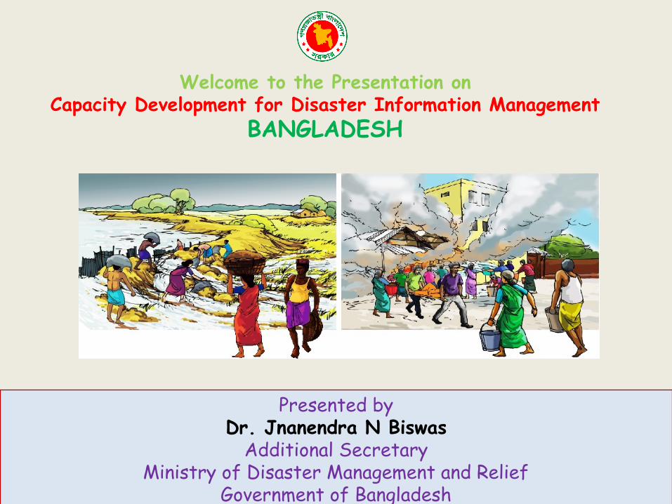
Welcome to the Presentation onCapacity Development for Disaster Information Management
BANGLADESH
Presented byDr. Jnanendra N Biswas
Additional SecretaryMinistry of Disaster Management and Relief
Government of Bangladesh
Context analysis:• Bangladesh, mostly by the virtue of its geophysical features, is a
disaster prone country which coupled with the global climate change poses a major threat for its residents and their livelihoods.
• In the year 1988 or more recently the cyclone SIDR which affected almost nine million people.
• Bangladesh has three main rivers flowing through which forms the largest delta in the world, these rivers are the Ganges, the Meghna and the Brahmaputra (GMB). The delta has flat territory with many other rivers flowing through it, which along with the above three rivers bring a vast amount of water and sediments .
• This process of carrying sediments has been taking place since the Miocene age and this in turn helped in the growth of the Bangladesh .
Ministry of Disaster Management and Relief
Context analysis: continue
• Bangladesh is seismically active also because of the presence of quite a few major and minor faults near the country .
• In the last 100 years (that is since 1900) as many as 100 earthquakes, ranging from moderate to high, has been reported in Bangladesh .
• These areas are the geographic reason for the susceptibility of earthquake in Bangladesh as near these areas there are some active fault zones . The country is divided into three seismic zones where the third zone has the most risk of seismic activity and zone-1 has the least .
• Moreover there are some seismic fault lines that pass through or near Bangladesh and pose a threat possible earthquake in the country; some of these are- Bogra fault, Sylhet fault, Dauki fault, Kopili fault and Jamuna fault
Ministry of Disaster Management and Relief
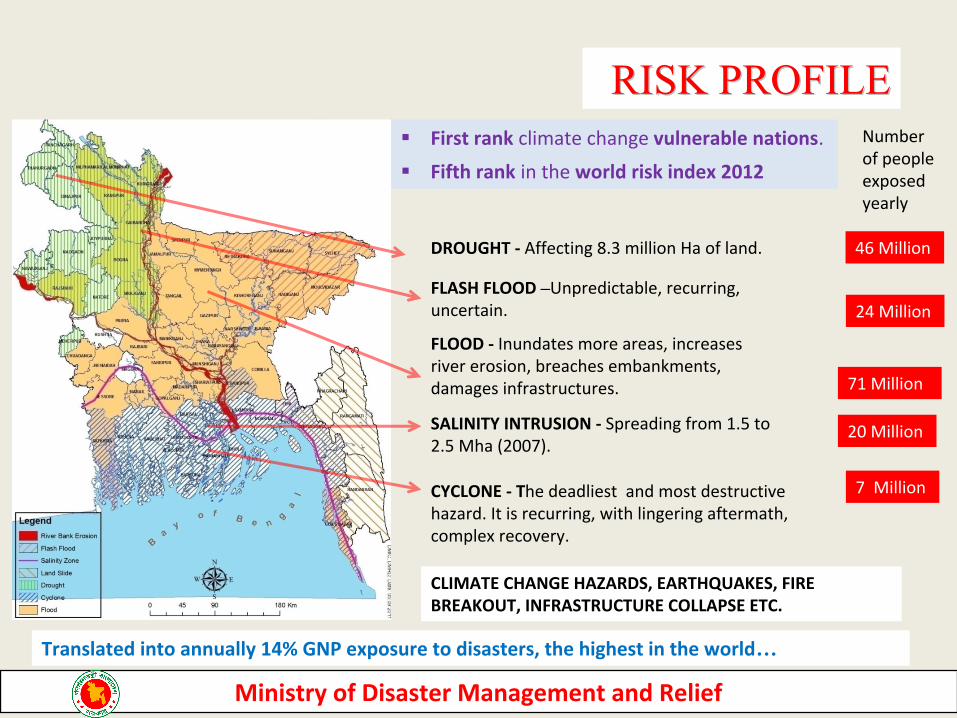
DROUGHT - Affecting 8.3 million Ha of land.
RISK PROFILERISK PROFILE
FLASH FLOOD –Unpredictable, recurring, uncertain.
FLOOD - Inundates more areas, increases river erosion, breaches embankments, damages infrastructures.
CYCLONE - The deadliest and most destructive hazard. It is recurring, with lingering aftermath, complex recovery.
First rank climate change vulnerable nations.
Fifth rank in the world risk index 2012
SALINITY INTRUSION - Spreading from 1.5 to 2.5 Mha (2007).
CLIMATE CHANGE HAZARDS, EARTHQUAKES, FIRE BREAKOUT, INFRASTRUCTURE COLLAPSE ETC.
Number of people exposed yearly
46 Million
24 Million
7 Million
Translated into annually 14% GNP exposure to disasters, the highest in the world…
71 Million
20 Million
Ministry of Disaster Management and Relief
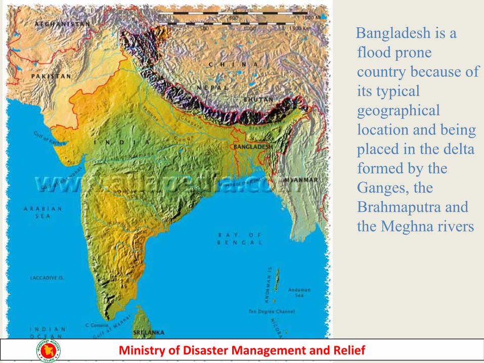
Bangladesh is a flood prone country because of its typical geographical location and being placed in the delta formed by the Ganges, the Brahmaputra and the Meghna rivers
Ministry of Disaster Management and Relief
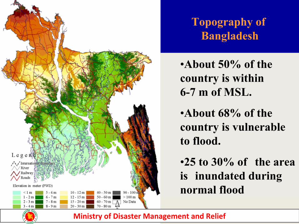
Topography of Bangladesh
•About 50% of the country is within 6-7 m of MSL.
•About 68% of the country is vulnerable to flood.
•25 to 30% of the area is inundated during normal flood
Ministry of Disaster Management and Relief
7
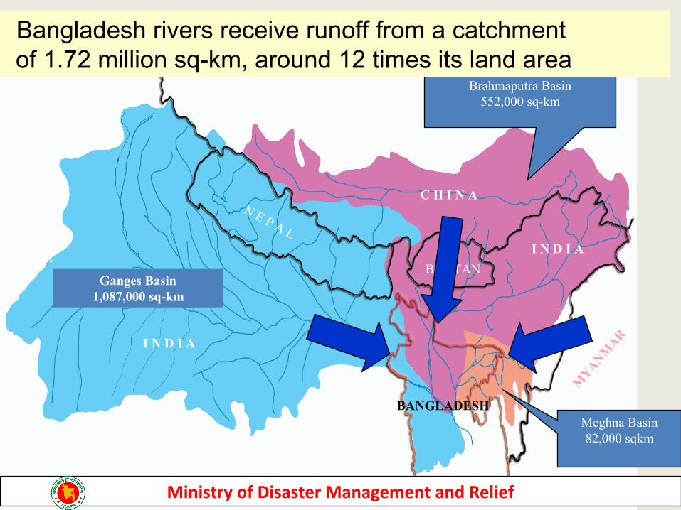
Meghna Basin82,000 sqkm
Brahmaputra Basin552,000 sq-km
Ganges Basin1,087,000 sq-km
B A Y O F B E N G A LB A Y O F B E N G A L
N E P A L
BHUTAN
I N D I A
C H I N A
MYANM
AR
BANGLADESH
I N D I A
Bangladesh rivers receive runoff from a catchment of 1.72 million sq-km, around 12 times its land area
Ministry of Disaster Management and Relief

Common Hazards/Disasters in Bangladesh
Ministry of Disaster Management and Relief
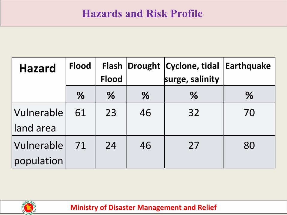
Hazards and Risk Profile
Total land area = 147,570 km2
Total Population = 142.3 Millions
Hazard Flood Flash Flood
Drought Cyclone, tidal surge, salinity
Earthquake
% % % % %Vulnerable land area
61 23 46 32 70
Vulnerable population
71 24 46 27 80
Ministry of Disaster Management and Relief
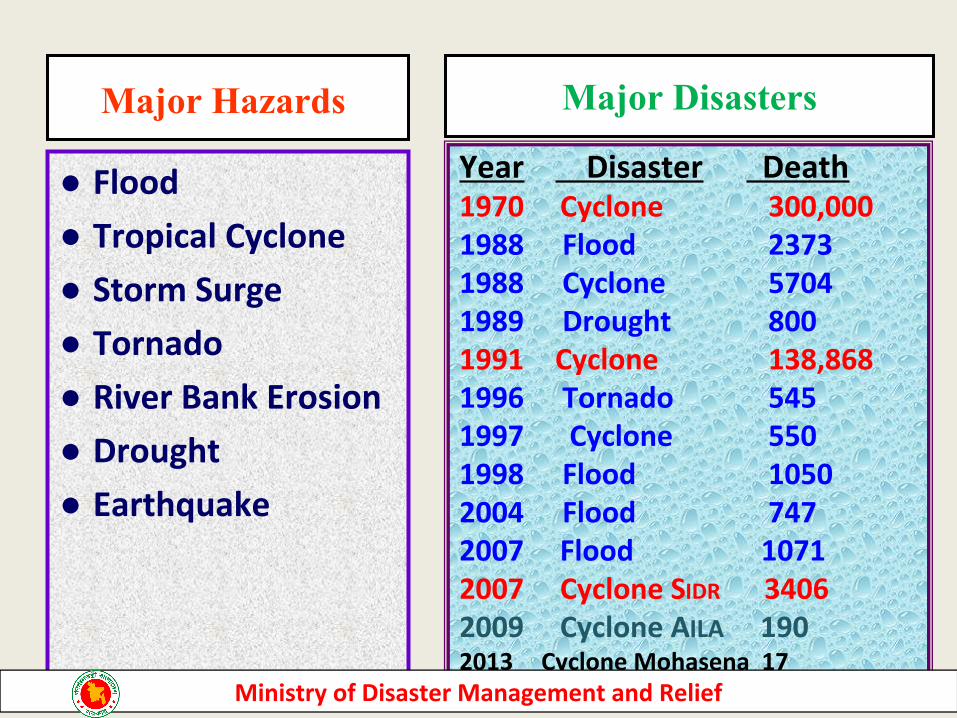
● Flood● Tropical Cyclone● Storm Surge● Tornado● River Bank Erosion● Drought● Earthquake
Year Disaster Death1970 Cyclone 300,0001988 Flood 23731988 Cyclone 57041989 Drought 8001991 Cyclone 138,8681996 Tornado 5451997 Cyclone 5501998 Flood 10502004 Flood 7472007 Flood 10712007 Cyclone SIDR 34062009 Cyclone AILA 1902013 Cyclone Mohasena 17
Major DisastersMajor Hazards
Ministry of Disaster Management and Relief
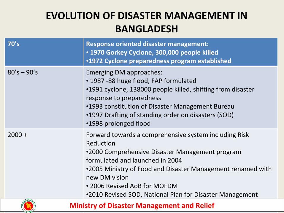
EVOLUTION OF DISASTER MANAGEMENT IN BANGLADESH
70’s Response oriented disaster management:• 1970 Gorkey Cyclone, 300,000 people killed•1972 Cyclone preparedness program established
80’s – 90’s Emerging DM approaches:• 1987 -88 huge flood, FAP formulated•1991 cyclone, 138000 people killed, shifting from disaster response to preparedness•1993 constitution of Disaster Management Bureau•1997 Drafting of standing order on disasters (SOD)•1998 prolonged flood
2000 + Forward towards a comprehensive system including Risk Reduction•2000 Comprehensive Disaster Management program formulated and launched in 2004•2005 Ministry of Food and Disaster Management renamed with new DM vision• 2006 Revised AoB for MOFDM•2010 Revised SOD, National Plan for Disaster Management• DM Policy and ACT draftedMinistry of Disaster Management and Relief
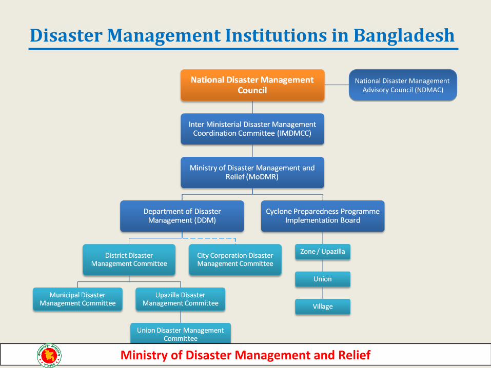
Disaster Management Institutions in Bangladesh
National Disaster Management Advisory Council (NDMAC)
Ministry of Disaster Management and Relief
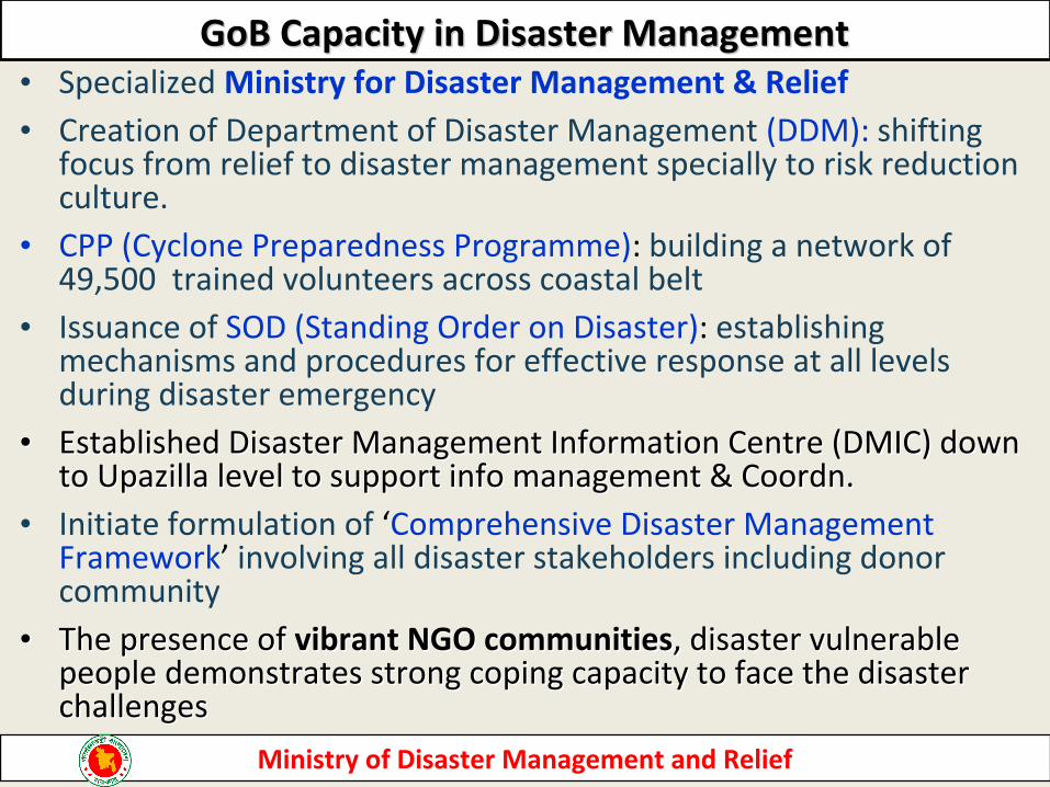
• Specialized Ministry for Disaster Management & Relief• Creation of Department of Disaster Management (DDM): shifting
focus from relief to disaster management specially to risk reduction culture.
• CPP (Cyclone Preparedness Programme): building a network of 49,500 trained volunteers across coastal belt
• Issuance of SOD (Standing Order on Disaster): establishing mechanisms and procedures for effective response at all levels during disaster emergency
•• Established Disaster Management Information Centre (DMIC) down Established Disaster Management Information Centre (DMIC) down to Upazilla level to support info management & Coordn.to Upazilla level to support info management & Coordn.
• Initiate formulation of ‘Comprehensive Disaster Management Framework’ involving all disaster stakeholders including donor community
•• The presence of The presence of vibrant NGO communitiesvibrant NGO communities, disaster vulnerable , disaster vulnerable people demonstrates strong coping capacity to face the disaster people demonstrates strong coping capacity to face the disaster challengeschallenges
1313
GoB Capacity in Disaster ManagementGoB Capacity in Disaster Management
Ministry of Disaster Management and Relief
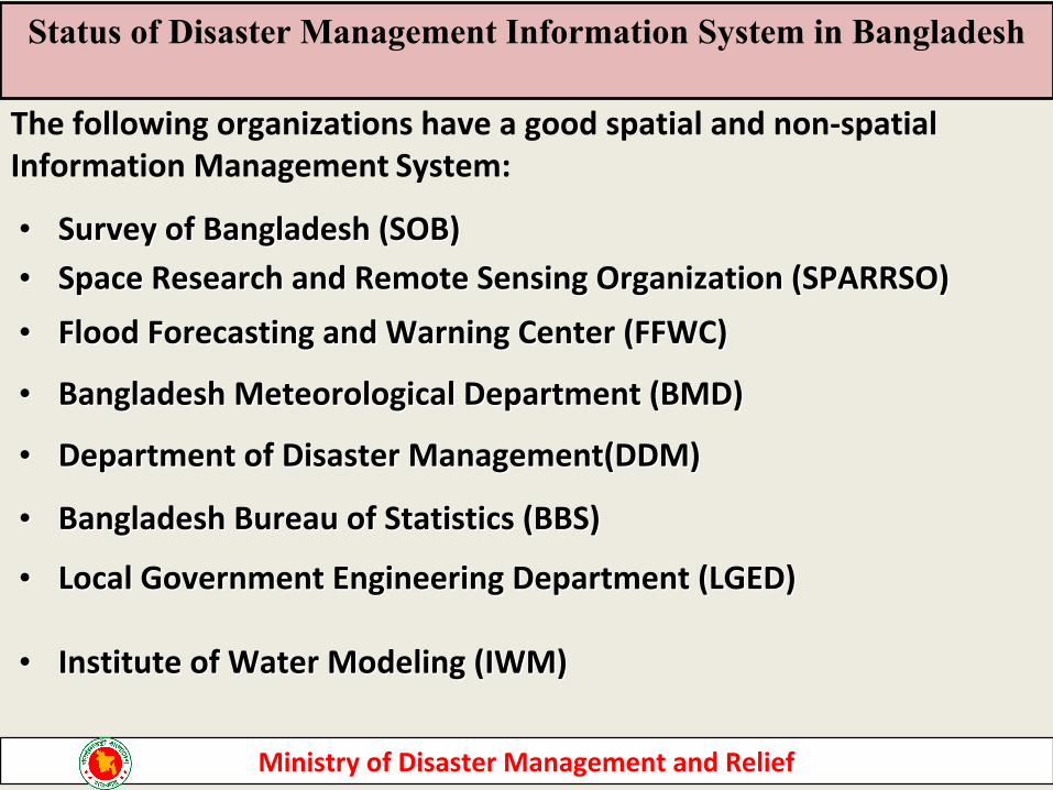
•• Survey of Bangladesh (SOB) Survey of Bangladesh (SOB) •• Space Research and Remote Sensing Organization (SPARRSO) Space Research and Remote Sensing Organization (SPARRSO)
•• Flood Forecasting and Warning Center (FFWC)Flood Forecasting and Warning Center (FFWC)
•• Bangladesh Meteorological Department (BMD) Bangladesh Meteorological Department (BMD)
•• Department of Disaster Management(DDM)Department of Disaster Management(DDM)
•• Bangladesh Bureau of Statistics (BBS) Bangladesh Bureau of Statistics (BBS)
•• Local Government Engineering Department (LGED)Local Government Engineering Department (LGED) •• Institute of Water Modeling (IWM)Institute of Water Modeling (IWM)
The following organizations have a good spatial and non-spatial Information Management System:
Status of Disaster Management Information System in Bangladesh
Ministry of Disaster Management and Relief
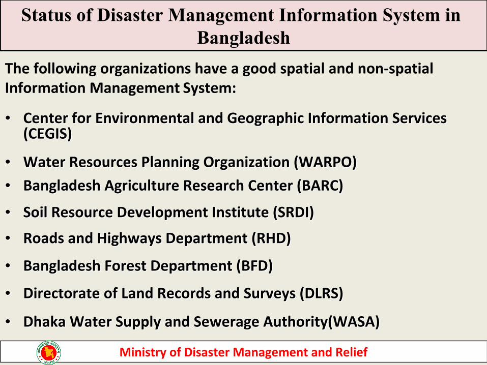
•• Center for Environmental and Geographic Information Services Center for Environmental and Geographic Information Services (CEGIS)(CEGIS)
•• Water Resources Planning Organization (WARPO) Water Resources Planning Organization (WARPO) •• Bangladesh Agriculture Research Center (BARC) Bangladesh Agriculture Research Center (BARC)
•• Soil Resource Development Institute (SRDI) Soil Resource Development Institute (SRDI)
•• Roads and Highways Department (RHD) Roads and Highways Department (RHD)
•• Bangladesh Forest Department (BFD) Bangladesh Forest Department (BFD)
•• Directorate of Land Records and Surveys (DLRS)Directorate of Land Records and Surveys (DLRS)
•• Dhaka Water Supply and Sewerage Authority(WASA)Dhaka Water Supply and Sewerage Authority(WASA)
The following organizations have a good spatial and non-spatial Information Management System:
Status of Disaster Management Information System in Bangladesh
Ministry of Disaster Management and Relief
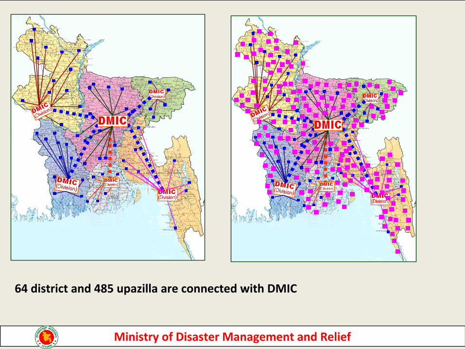
District/Upazilla DMIC Conectivity
64 district and 485 upazilla are connected with DMIC
Ministry of Disaster Management and Relief
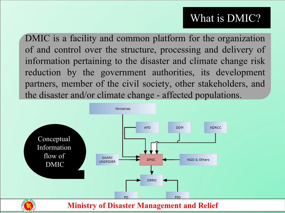
DMIC is a facility and common platform for the organization of and control over the structure, processing and delivery of information pertaining to the disaster and climate change risk reduction by the government authorities, its development partners, member of the civil society, other stakeholders, and the disaster and/or climate change - affected populations.
What is DMIC?
Conceptual Information
flow of DMIC
Ministry of Disaster Management and Relief
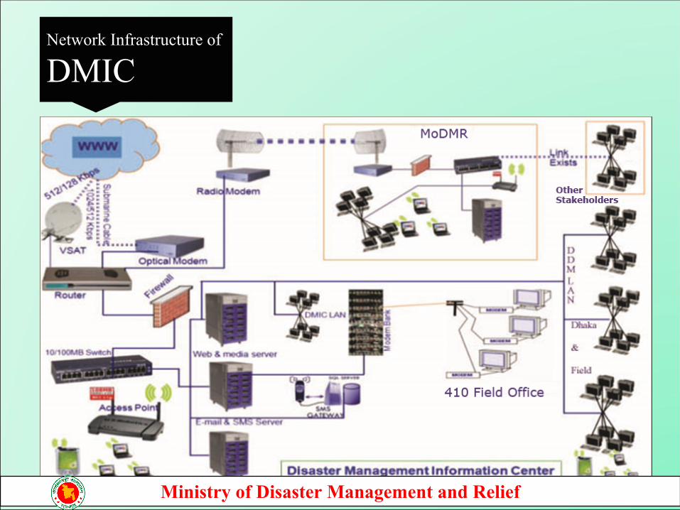
Network Infrastructure of
DMIC
Ministry of Disaster Management and Relief
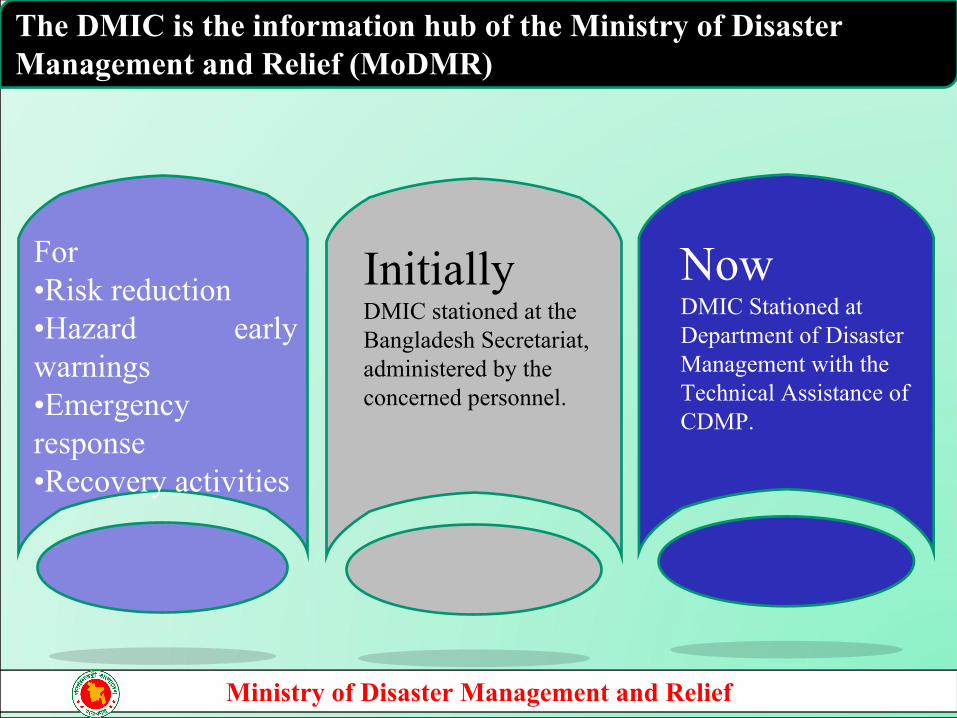
Initially DMIC stationed at the Bangladesh Secretariat, administered by the concerned personnel.
For•Risk reduction •Hazard early warnings •Emergency response•Recovery activities
Now DMIC Stationed at Department of Disaster Management with the Technical Assistance of CDMP.
The DMIC is the information hub of the Ministry of Disaster Management and Relief (MoDMR)
Ministry of Disaster Management and Relief
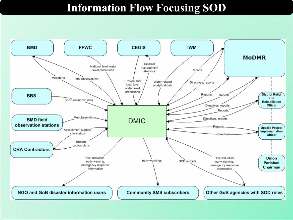
Information Flow Focusing SOD
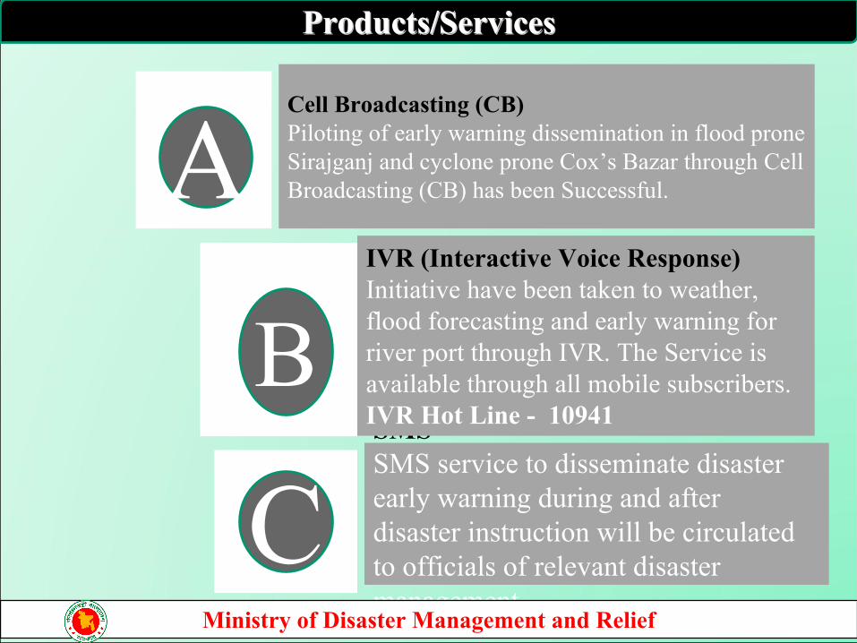
Cell Broadcasting (CB)Piloting of early warning dissemination in flood prone Sirajganj and cyclone prone Cox’s Bazar through Cell Broadcasting (CB) has been Successful.
SMSSMS service to disseminate disaster early warning during and after disaster instruction will be circulated to officials of relevant disaster management.
A
B
C
IVR (Interactive Voice Response) Initiative have been taken to weather, flood forecasting and early warning for river port through IVR. The Service is available through all mobile subscribers. IVR Hot Line - 10941
Products/ServicesProducts/Services
Ministry of Disaster Management and Relief
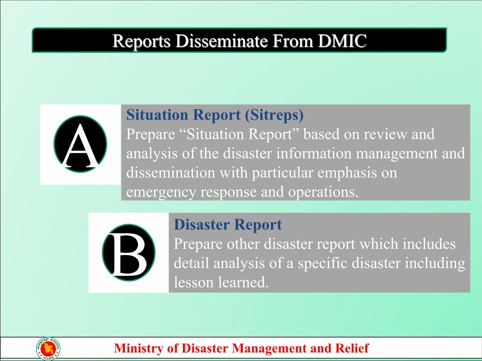
Situation Report (Sitreps)Prepare “Situation Report” based on review and analysis of the disaster information management and dissemination with particular emphasis on emergency response and operations.
A
BDisaster Report Prepare other disaster report which includes detail analysis of a specific disaster including lesson learned.
Reports Disseminate From DMICReports Disseminate From DMIC
Ministry of Disaster Management and Relief
BMD
DMIC
FFWC
CDMP II
MoD
MR
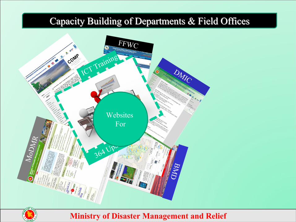
ICT Training
364 Upazilas
Capacity Building of Departments & Field OfficesCapacity Building of Departments & Field Offices
Websites For
Ministry of Disaster Management and Relief
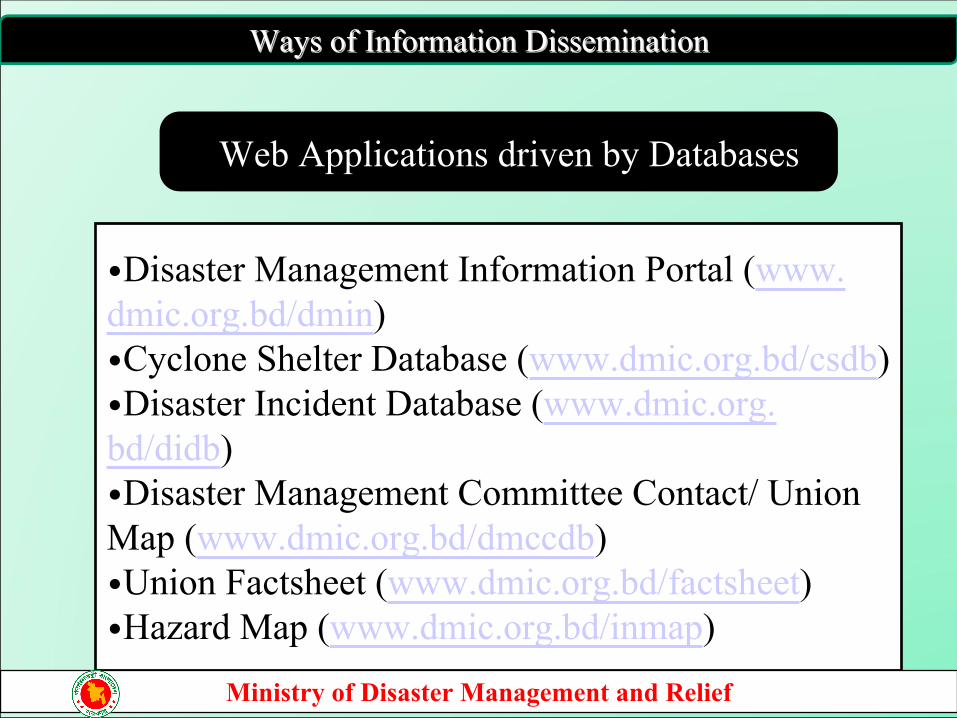
•Disaster Management Information Portal (www.dmic.org.bd/dmin) •Cyclone Shelter Database (www.dmic.org.bd/csdb)•Disaster Incident Database (www.dmic.org.bd/didb)•Disaster Management Committee Contact/ Union Map (www.dmic.org.bd/dmccdb)•Union Factsheet (www.dmic.org.bd/factsheet)•Hazard Map (www.dmic.org.bd/inmap)
Web Applications driven by Databases
Ways of Information DisseminationWays of Information Dissemination
Ministry of Disaster Management and Relief
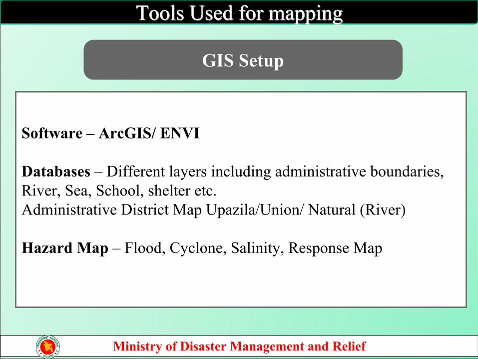
Software – ArcGIS/ ENVI
Databases – Different layers including administrative boundaries, River, Sea, School, shelter etc. Administrative District Map Upazila/Union/ Natural (River)
Hazard Map – Flood, Cyclone, Salinity, Response Map
GIS Setup
Tools Used for mappingTools Used for mapping
Ministry of Disaster Management and Relief
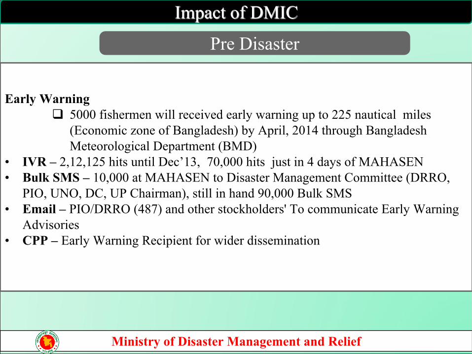
Impact of DMICImpact of DMIC
Pre Disaster
Ministry of Disaster Management and Relief
Early Warning 5000 fishermen will received early warning up to 225 nautical miles
(Economic zone of Bangladesh) by April, 2014 through Bangladesh Meteorological Department (BMD)
• IVR – 2,12,125 hits until Dec’13, 70,000 hits just in 4 days of MAHASEN• Bulk SMS – 10,000 at MAHASEN to Disaster Management Committee (DRRO,
PIO, UNO, DC, UP Chairman), still in hand 90,000 Bulk SMS• Email – PIO/DRRO (487) and other stockholders' To communicate Early Warning
Advisories• CPP – Early Warning Recipient for wider dissemination
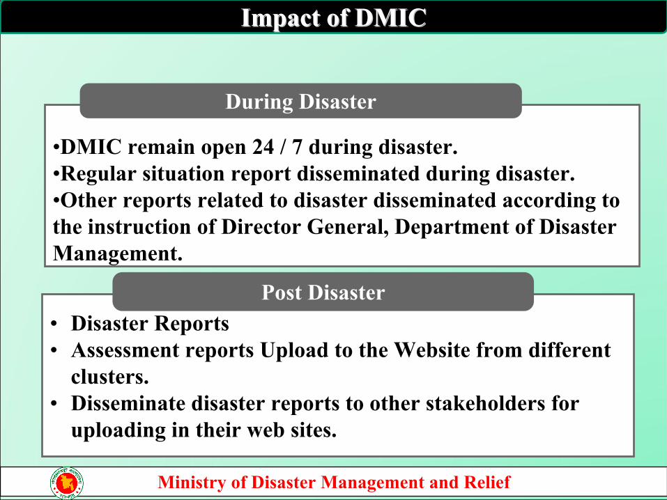
Impact of DMICImpact of DMIC
• Disaster Reports• Assessment reports Upload to the Website from different
clusters.• Disseminate disaster reports to other stakeholders for
uploading in their web sites.
Post Disaster
•DMIC remain open 24 / 7 during disaster. •Regular situation report disseminated during disaster.•Other reports related to disaster disseminated according to the instruction of Director General, Department of Disaster Management.
During Disaster
Ministry of Disaster Management and Relief
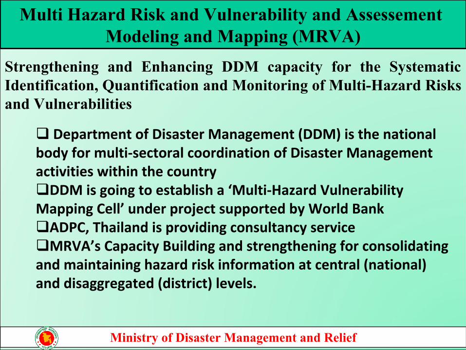
Multi Hazard Risk and Vulnerability and Assessement Modeling and Mapping (MRVA)
Strengthening and Enhancing DDM capacity for the Systematic Identification, Quantification and Monitoring of Multi-Hazard Risks and Vulnerabilities
Department of Disaster Management (DDM) is the national body for multi-sectoral coordination of Disaster Management activities within the countryDDM is going to establish a ‘Multi-Hazard Vulnerability Mapping Cell’ under project supported by World BankADPC, Thailand is providing consultancy serviceMRVA’s Capacity Building and strengthening for consolidating and maintaining hazard risk information at central (national) and disaggregated (district) levels.
Ministry of Disaster Management and Relief
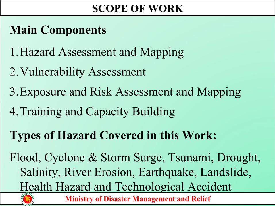
Main Components
1.Hazard Assessment and Mapping2.Vulnerability Assessment3.Exposure and Risk Assessment and Mapping4.Training and Capacity Building
Types of Hazard Covered in this Work:
Flood, Cyclone & Storm Surge, Tsunami, Drought, Salinity, River Erosion, Earthquake, Landslide, Health Hazard and Technological Accident
SCOPE OF WORK
Ministry of Disaster Management and Relief
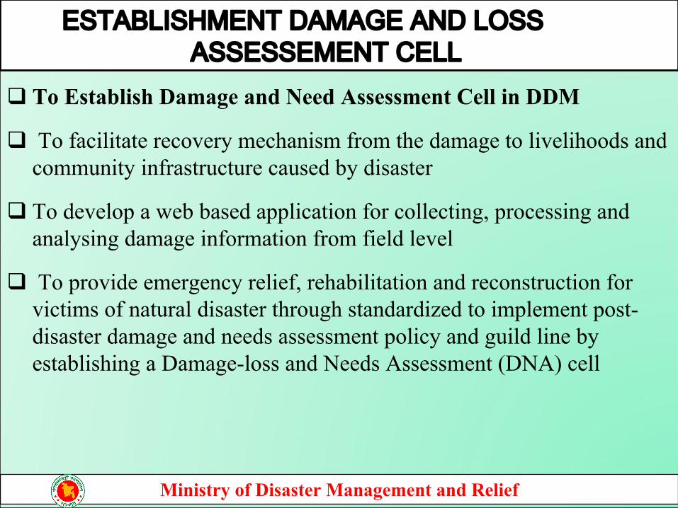
To Establish Damage and Need Assessment Cell in DDM
To facilitate recovery mechanism from the damage to livelihoods and community infrastructure caused by disaster
To develop a web based application for collecting, processing and analysing damage information from field level
To provide emergency relief, rehabilitation and reconstruction for victims of natural disaster through standardized to implement post-disaster damage and needs assessment policy and guild line by establishing a Damage-loss and Needs Assessment (DNA) cell
ESTABLISHMENT DAMAGE AND LOSS ASSESSEMENT CELL
Ministry of Disaster Management and Relief
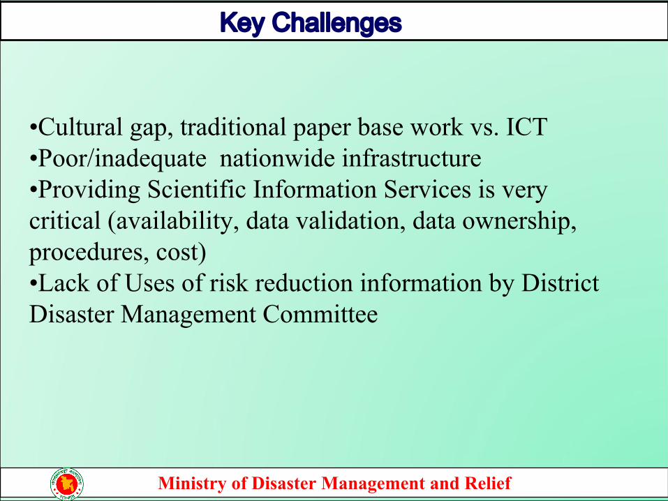
Key Challenges
•Cultural gap, traditional paper base work vs. ICT•Poor/inadequate nationwide infrastructure•Providing Scientific Information Services is very critical (availability, data validation, data ownership, procedures, cost)•Lack of Uses of risk reduction information by District Disaster Management Committee
Ministry of Disaster Management and Relief
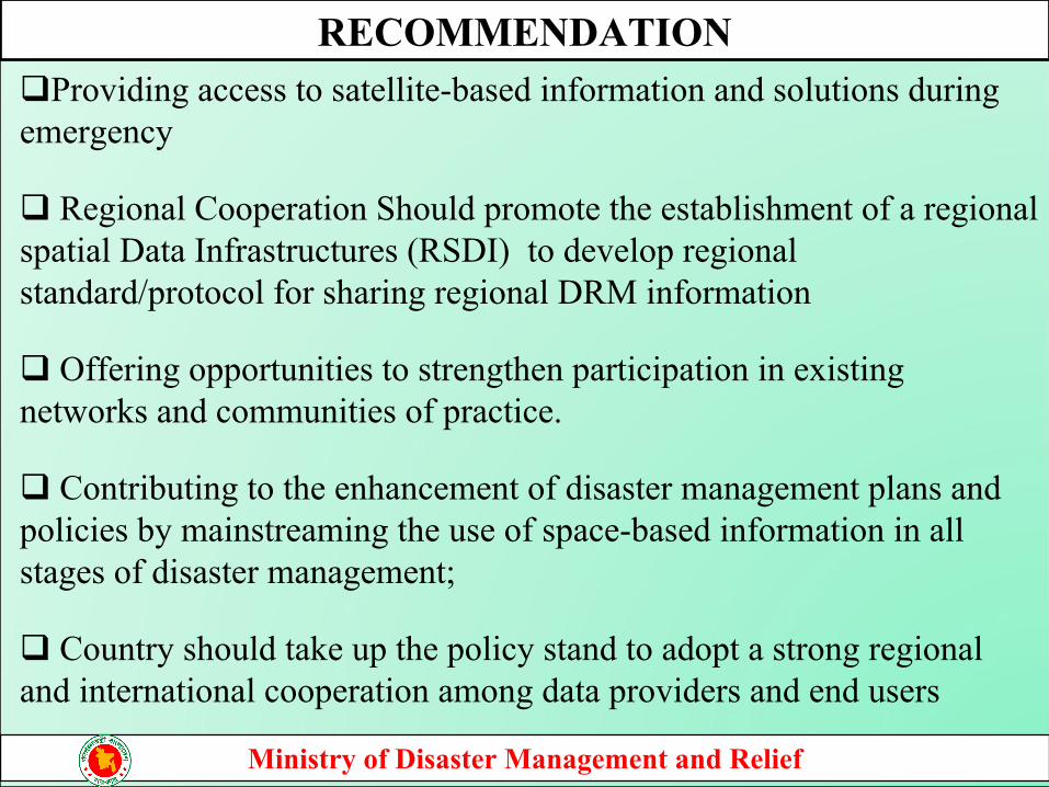
Providing access to satellite-based information and solutions during emergency
Regional Cooperation Should promote the establishment of a regional spatial Data Infrastructures (RSDI) to develop regional standard/protocol for sharing regional DRM information
Offering opportunities to strengthen participation in existing networks and communities of practice.
Contributing to the enhancement of disaster management plans and policies by mainstreaming the use of space-based information in all stages of disaster management;
Country should take up the policy stand to adopt a strong regional and international cooperation among data providers and end users
RECOMMENDATION
Ministry of Disaster Management and Relief
To Establish Damage and Need Assessment Cell in DDM
To facilitate recovery mechanism from the damage to livelihoods and community infrastructure caused by disaster
To develop a web based application for collecting, processing and analysing damage information from field level
To provide emergency relief, rehabilitation and reconstruction for victims of natural disaster through standardized to implement post-disaster damage and needs assessment policy and guild line by establishing a Damage-loss and Needs Assessment (DNA) cell
ESTABLISHMENT DAMAGE AND LOSS ASSESSEMENT CELL
Ministry of Disaster Management and Relief
• South and South-West Asian countries could focus on several priority areas for developing disaster risk reduction strategies and implementation over the short- to medium-term. Given the sub region’s simultaneous and high disaster risk and economic vulnerability, there is significant scope for countries to consider improved methods and policies that can address disaster risk reduction in the context of multiple shocks. Both immediate and longer-term policy actions to increase resilience to disasters compounded by other external shocks should be considered and mainstreamed into national disaster risk reduction action plans.
Ministry of Disaster Management and Relief
Conclusion

THANK YOU