Webber Greens Neighbourhood Structure Plan · Webber Greens Neighbourhood Structure Plan Office...
32
Webber Greens Neighbourhood Structure Plan Office Consolidation April 2011 Prepared by: Planning and Policy Services Branch Planning and Development Department City of Edmonton Bylaw 12360 (as amended) was adopted by Council on July 18, 2000. In April 2011, this document was consolidated by virtue of the incorporation of the following bylaws, which were amendments to the original Bylaw 12360. This Plan is an amendment to the Lewis Farms Area Structure Plan, Bylaw 8733, as approved by Council in June 14, 1988. Bylaw 12360 Approved July 18, 2000 (to incorporate the Webber Greens NSP in to the Lewis Farms ASP) Bylaw 13662 Approved April 7, 2004 (to update maps and tables in Webber Greens NSP) Bylaw 15365 Approved February 17, 2010 (facilitate revisions to the commercial and residential land uses, the parks and school site, collector roadway and the stormwater management facility) Bylaw 15645 Approved January 31, 2011 (to designate a site south of Winterburn School for school/park uses and reconfigure the size and size of the medium-density site next to the Lewis Estates Golf Course) Editor’s Note: This is an office consolidation edition for the Webber Greens Neighbourhood Structure Plan, as approved by City Council on July 18, 2000. This Plan is an amendment to the Lewis Farms Area Structure Plan, Bylaw 8733 as approved by City Council on June 14, 1988. This edition contains all amendments and additions to Bylaw 12360. For the sake of clarity, new maps and a standardized format were utilized in this Plan. All names of City departments have been standardized to reflect their present titles. Private owner’s names have been removed in accordance with the Freedom of Information and Protection of Privacy Act. Furthermore, all reasonable attempts were made to accurately reflect the original Bylaws. All text changes are noted in the right margin and are italicized where applicable. This office consolidation is intended for convenience only. In case of uncertainty, the reader is advised to consult the original Bylaws, available at the office of the City Clerk. City of Edmonton Planning and Development Department
Transcript of Webber Greens Neighbourhood Structure Plan · Webber Greens Neighbourhood Structure Plan Office...
Webber Greens Neighbourhood Structure Plan
Office Consolidation April 2011
Prepared by:
Planning and Policy Services Branch Planning and Development Department
City of Edmonton Bylaw 12360 (as amended) was adopted by Council on July 18, 2000. In April 2011, this document was consolidated by virtue of the incorporation of the following bylaws, which were amendments to the original Bylaw 12360. This Plan is an amendment to the Lewis Farms Area Structure Plan, Bylaw 8733, as approved by Council in June 14, 1988. Bylaw 12360 Approved July 18, 2000 (to incorporate the Webber Greens NSP in to the Lewis Farms ASP)
Bylaw 13662 Approved April 7, 2004 (to update maps and tables in Webber Greens NSP)
Bylaw 15365 Approved February 17, 2010 (facilitate revisions to the commercial and residential land uses, the parks and school site, collector roadway and the stormwater management facility)
Bylaw 15645 Approved January 31, 2011 (to designate a site south of Winterburn School for school/park uses and reconfigure the size and size of the medium-density site next to the Lewis Estates Golf Course)
Editor’s Note: This is an office consolidation edition for the Webber Greens Neighbourhood Structure Plan, as approved by City Council on July 18, 2000. This Plan is an amendment to the Lewis Farms Area Structure Plan, Bylaw 8733 as approved by City Council on June 14, 1988. This edition contains all amendments and additions to Bylaw 12360. For the sake of clarity, new maps and a standardized format were utilized in this Plan. All names of City departments have been standardized to reflect their present titles. Private owner’s names have been removed in accordance with the Freedom of Information and Protection of Privacy Act. Furthermore, all reasonable attempts were made to accurately reflect the original Bylaws. All text changes are noted in the right margin and are italicized where applicable. This office consolidation is intended for convenience only. In case of uncertainty, the reader is advised to consult the original Bylaws, available at the office of the City Clerk. City of Edmonton Planning and Development Department
2 Webber Greens NSP Office Consolidation
TABLE OF CONTENTS NEIGHBOURHOOD STRUCTURE PLAN .................................................................................. 3 Webber Greens Neighbourhood Structure Plan .............................................................................. 4 Table 1: Webber Greens Neighbourhood Structure Plan .............................................................. 5 Chapter 1: Introduction.................................................................................................................. 6 Chapter 2: Background.................................................................................................................. 7 Figure 1: Location Plan ................................................................................................................... 8 Figure 2: Area Structure Plan.......................................................................................................... 9 Chapter 3: Factors Influencing Development.............................................................................. 10
3.1 Policy Context.................................................................................................................... 10 3.2 Ownership.......................................................................................................................... 12 3.3 Existing Land Use.............................................................................................................. 12 3.4 Resource Extraction........................................................................................................... 13 3.5 Adjacent Land Use............................................................................................................. 13 3.6 Natural Features................................................................................................................. 14 3.7 Environmental Site Assessment......................................................................................... 14 3.8 Historical/Cultural Resources ............................................................................................ 15
Figure 3: Ownership (As Amended by Editor).............................................................................. 16 Figure 4: Air Photo........................................................................................................................ 17 Figure 5: Resource Extraction....................................................................................................... 18 Figure 6: Natural Features............................................................................................................. 19 Chapter 4: Development Objectives............................................................................................ 20 Figure 7: Development Concept.................................................................................................... 21 Figure 8: Water.............................................................................................................................. 22 Chapter 5: Development Concept ............................................................................................... 23
5.1 Land Use............................................................................................................................ 23 5.2 Demography...................................................................................................................... 25 5.3 Transportation.................................................................................................................... 25 5.4 Utility Servicing................................................................................................................. 26
Chapter 6: Development Sequence .............................................................................................. 28 Figure 9: Sanitary Sewer ............................................................................................................... 29 Figure 10: Development Sequence................................................................................................ 30 Chapter 7: Rationale.................................................................................................................... 31
3
NEIGHBOURHOOD STRUCTURE PLAN
WEBBER GREENS NEIGHBOURHOOD -
LEWIS FARMS
Office Consolidation April 2011
Prepared by Scheffer Andrew Ltd.
May 2000
4 Webber Greens NSP Office Consolidation
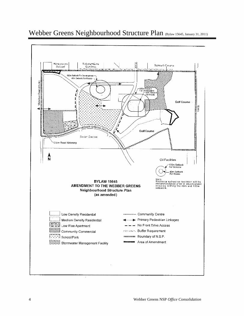
Webber Greens Neighbourhood Structure Plan (Bylaw 15645, January 31, 2011)
5
Table 1: Webber Greens Neighbourhood Structure Plan Bylaw 15645
January 31, 2011
Land Use and Population Statistics
AREA (HA) % OF GDA
Gross Area 112.13 Golf Course 28.60 Arterial (Webber Greens Drive & 215 Street)
3.32
Gross Developable Area 80.21
Circulation 15.90 19.82 School/Park 11.25 14.03 Stormwater Management Facility
6.25 7.79
Community Commercial 4.57 5.70 Low Density Residential 30.02 37.43 Medium Density Residential 11.01 13.73 Medium Density Low Rise Apartment
1.21 1.50
Total 80.21 100.00
AREA (HA) DU/HA UNITS % OF TOTAL UNITS
POPULATION PPDU
Low Density Residential 30.02 25 750 55.4 2,100 2.8 Medium Density Residential 11.01 45 495 36.6 1,386 2.8 Medium Density Low Rise Apartment
1.21 90 108 8.0 194 1.8
Total 42.24 1,353 100.0 3,680 Neighbourhood 4 Density 41.1 persons per gross developable hectare
29.2 persons per gross hectare Student Generation ELEMENTARY JUNIOR
HIGH SENIOR
HIGH TOTAL
Public 160 80 80 320 2 students elementary, 1 student junior and senior high per gross
developable hectare Catholic 80 40 40 160 1 students elementary, 0.5
students junior and senior high per gross developable hectare
Total 240 120 120 480
6 Webber Greens NSP Office Consolidation
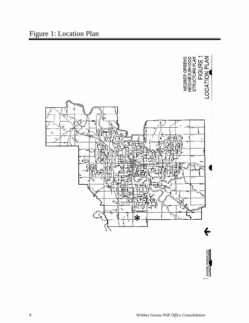
Chapter 1: Introduction This plan for Webber Greens Neighbourhood in Lewis Farms has been prepared on
behalf of a private corporation in compliance with the Lewis Farms area structure plan
as amended. The general location of Webber Greens Neighbourhood is shown in Figure
1.
Amended by Editor
7 Webber Greens NSP Office Consolidation
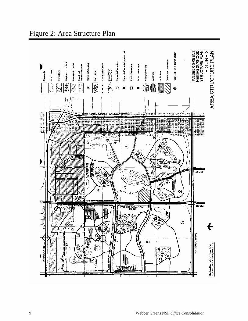
Chapter 2: Background
The Lewis Farms area structure plan was originally approved in 1988. It defined a
Neighbourhood 4 (now Webber Greens Neighbourhood) bounded by the proposed 95th
Avenue on the south, Winterburn Road (215 Street) to the west, and the proposed 204
Street to the east, It is bounded on the north by the existing Winterburn School site and
the Normandeau Gardens country residential subdivision.
Since the area structure plan's approval in 1988, residential development has proceeded
in two of the eight neighbourhoods in the area structure plan area. The Potter Greens
Neighbourhood Structure Plan (Bylaw No. 9390) was approved by Council on February
13, 1990 and the Breckenridge Greens Neighbourhood Structure Plan (Bylaw No. 9925)
was approved on October 8, 1991. The 18 hole Lewis Estates Golf Course has been
developed in conjunction with these neighbourhoods. However, no development related
to the implementation of the Lewis Farms area structure plan has occurred within the
boundaries of Webber Greens Neighbourhood.
A reconfiguration of the back nine holes of the golf course was described in an
amendment to the area structure plan (Bylaw No. 10881) which was adopted by Council
on November 29, 1994. A second amendment was adopted by Council on December 6,
1999 as Bylaw No. 12183. This amendment, among other changes, realigned 95 Avenue
and reduced 204 Street between 95 Avenue and Stony Plain Road to collector status.
A further amendment, Bylaw 12184, was also adopted on December 6, 1999. Among
other things, it altered the storm water drainage concept for Webber Greens
Neighbourhood. Figure 2 shows the location and boundaries of Webber Greens
Neighbourhood in the context of the amended Lewis Farms Area Structure Plan
development concept.
8 Webber Greens NSP Office Consolidation
Figure 1: Location Plan
9 Webber Greens NSP Office Consolidation
Figure 2: Area Structure Plan
10 Webber Greens NSP Office Consolidation
Chapter 3: Factors Influencing Development
3.1 Policy Context 3.1.1 Lewis Farms Area Structure Plan The Lewis Farms Area Structure Plan (as amended) provides a general framework for
future development of a 10 square kilometre area in west Edmonton. The area is
bounded by the Transportation Utility Corridor (TUC) to the east, Stony Plain Road
(Highway 16A) on the north, Whitemud Drive (79 Avenue) on the south, and the City
Boundary (231 Street) on the west. The area structure plan describes the general pattern
of land use, a conceptual pattern of major roads, and utility servicing scheme for the
area. The area structure plan area includes business/industrial areas, eight residential
neighbourhoods, and a golf course.
This neighbourhood structure plan is generally consistent with the Lewis Farms Area
Structure Plan, as amended.
3.1.2 Municipal Development Plan This neighbourhood structure plan is in general conformity with the City of Edmonton's
Municipal Development Plan which was approved August 31, 1998 (Bylaw No. 11777).
With respect to internal land use and transportation, the proposed development is
consistent with the Lewis Farms Area Structure Plan (as amended in December 1999),
which is in turn consistent with the Municipal Development Plan.
The Municipal Development Plan contains several policies encouraging the efficient use
of existing municipal infrastructure. Un-used capacity exists in sanitary and storm
sewers north east of Lewis farms. Stony Plain Road has un-used traffic capacity.
Development in the north portion of Lewis farms will make use of this capacity,
resulting in a more efficient use of municipal infrastructure.
The Municipal Development Plan also promotes development that is contiguous to
existing development. The subject development, proposed to commence just south of
the Winterburn Road/Stony Plain Road interchange, is contiguous to existing
residential, commercial, institutional, and major roadway development. However, given
that the Transportation Utility Corridor and the Lewis Estates Golf Course separate the
north portion of Lewis Farms from the major utilities to which it must connect,
11 Webber Greens NSP Office Consolidation
development in the area can never be literally contiguous with existing services in west
Edmonton.
The concept of contiguous development must also reflect consideration of major roads
and access opportunities. Opportunities for access to Stony Plain Road east of
Winterburn Road are likely to be severely limited in the future. No direct access will be
available from Anthony Henday Drive. Although the northeast comer of Lewis Farms is
physically near these facilities, this area cannot be regarded as being contiguous to them
in a practical sense. Only the Winterburn Road connection to Stony Plain Road offers
an appropriate arterial access opportunity for substantial urban development in the north
portion of Lewis Farms. As a practical matter, this location is the only one in the north
portion of Lewis Farms that is contiguous to existing development.
The Municipal Development Plan seeks to minimise the financial impact of new
development. Fiscally responsible development requires that the infrastructure design be
efficient and that the means of funding proposed development does not place an
unacceptable cost burden on the City. The servicing concept for the north portion of
Lewis Farms has been approved by the City of Edmonton Drainage Branch through
their support of the amended Master Drainage Plan for Lewis Farms. The efficiency of
the servicing concept for the north portion of Lewis Farms is not in question.
With respect to the fiscal impact of the proposed development on the City of Edmonton,
four major areas of potential cost must be addressed:
Sanitary Sewer - On-site development costs (for infrastructure within Lewis Farms)
must be borne by the development industry. Offsite costs will come under the Sanitary
Sewer Strategy Fund.
Storm Drainage - On-site development costs (for infrastructure within Lewis Farms)
must be borne by the development industry. The storm water management scheme has
been designed to use existing off-site capacity. There will be no additional off-site storm
drainage costs associated with the proposed development.
Water Supply - Connection to the municipal water supply is available within Lewis
Farms. The cost of extending this service will be borne initially by the development
industry, which will recover these costs as further development occurs.
Roads - The required upgrading of Winterburn Road south from Stony Plain Road will
12 Webber Greens NSP Office Consolidation
be done at the developers’ cost, in accordance with City policy. Ultimate development
of this road will not occur until justified by demand in the overall Lewis Farms area.
The Municipal Development Plan, while stressing contiguous development, efficient
servicing, and the minimisation of the fiscal impact of new development, also
recognises the need to respond to market demand and to provide for choices in housing
type and location. Residential development near the intersection of Winterburn Road
and Stony Plain Road strikes an appropriate balance between these concerns and is
therefore consistent with the Municipal Development Plan.
3.1.3 Land Use Bylaw All of Webber Greens Neighbourhood is districted agricultural (AG) under the 1981
County of Parkland Land Use Bylaw. Implementation of this amendment will require
that the subject lands be redistricted to City of Edmonton Land Use Bylaw districts.
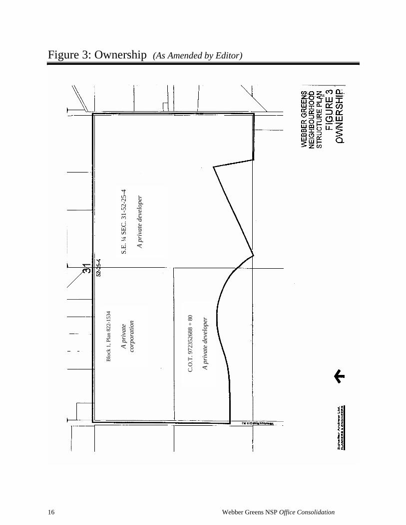
3.2 Ownership Figure 3 shows current land ownership within the boundary of Webber Greens
Neighbourhood. There are two major holdings within this neighbourhood. The largest
of these, totalling approximately 79 hectares, is owned by a private developer. A private
developer owns approximately 32 hectares in the north half of SW 31-52-25-4 (Block 1,
Plan 822-1534) which is subject to an agreement for sale to a private corporation.
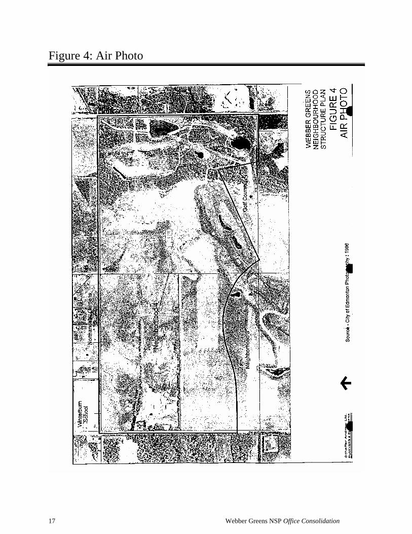
3.3 Existing Land Use Figure 4 shows Webber Greens Neighbourhood as it existed in 1996. It is essentially
unchanged today. The golf course has been developed in the east and southeast portion
of the neighbourhood. The majority of the remaining land is in agricultural use or is
undeveloped. A farmstead exists near the west boundary of the neighbourhood, but none
of the buildings will be retained.
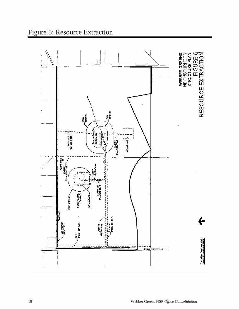
3.4 Resource Extraction As shown in Figure 5, one well site containing two producing crude oil wells exists in
Webber Greens Neighbourhood. Various flow lines connect this site and others to a
Suncor Energy battery site in the east portion of the neighbourhood. An Imperial Oil
"gathering" line flows from the battery site west to Winterburn Road and from there
Amended by Editor
13 Webber Greens NSP Office Consolidation
south. A Northwestern Utilities Ltd. natural gas line abuts the east boundary of
Winterburn Road. None of these facilities are major high pressure lines.
The City's current regulations regarding the location of development near resource
extraction facilities are detailed in the City of Edmonton’s "Policy Guidelines for the
Integration of Resource Operations and Urban Development” (September 24, 1985).
Minimum setback distances from resource extraction facilities and pipelines are
specified.
While the well and battery sites are in operation, subdivision and development must
adhere to the City’s policy guidelines. Eventually, however, these facilities will be
abandoned and the sites can be developed for other uses. In the interim, it is possible
that, with the agreement of the operators, some of the flow lines and gathering lines may
be relocated (at the developers’ expense) to better accommodate urban development.
Flow lines within the school/park site will be relocated by the developer as required by
and to the satisfaction of the City of Edmonton Community Services Department.
3.5 Adjacent Land Use The land to the south is designated, under the area structure plan, as residential
(Neighbourhood 3) and is currently in agricultural use. The remainder of the completed
18 hole golf course is directly south. The eastern boundary is defined by the
Transportation and Utility Corridor and Anthony Henday Drive. The western boundary
is Winterburn Road, beyond which lies future residential land which is currently in
agricultural use or undeveloped. The nearest suburban residential development is south
of 87th Avenue in the Breckenridge Greens and Potter Greens neighbourhoods.
At present, the land to the north of Webber Greens Neighbourhood is designated under
the Lewis Farms Area subdivision and the Winterburn School. The approved Area
Structure Plan acknowledges that consideration should be given, at the neighbourhood
plan stage, to the provision of "special buffer treatment" where residential development
will abut business/industria1. Required buffering will be provided as part of the
industrial development. It will consist of a berm and/or screen fence with appropriate
landscaping, the details of which will be determined at the time based on the
performance standards contained in the Land Use Bylaw, and the specific type of
industrial development contemplated. Only the 113 District of the current City of
Edmonton Land Use Bylaw is recognised as being compatible with adjacent residential
development. The performance standards within this district place the responsibility for
14 Webber Greens NSP Office Consolidation
buffering on the industrial development Structure Plan for business/industrial use. This
area includes the existing Normandeau Gardens country residential
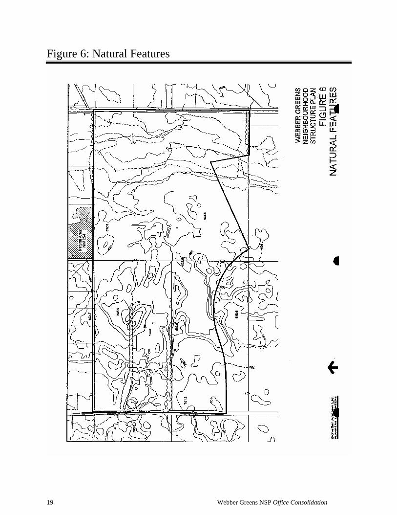
3.6 Natural Features Webber Greens Neighbourhood is adjacent to the 7.6 ha Normandeau Gardens Natural
Area, identified in the City's "Inventory of Environmentally Sensitive and Significant
Natural Areas"(1994) as site NW 254. This natural area is not within the
neighbourhood, thus no Natural Site Assessment is required.
The McDonagh Peatland natural area (NW 7009-35.5 hectares) is near the
neighbourhood’s east end. This area has already been developed as part of the golf
course.
Topography and vegetation within the Webber Greens Neighbourhood boundary are
shown in Figure 6. The neighbourhood has a topographical variation of approximately
10-11 m, with natural drainage to the east.
3.7 Environmental Site Assessment A Phase I Environmental Site Assessment (ESA) has been prepared for Webber Greens
Neighbourhood to identify any potential concerns with respect to site contamination
resulting from existing or historical use within the area. The report concluded that a
Phase II Environmental Site Assessment was required for a small part of the plan area
near the west boundary. The area assessed in the Phase II report had formerly contained
both an underground and an aboveground storage tank. Analytical soil and groundwater
chemistry tests were performed and concluded that any potential contaminants found
were well within the accepted standards. This report, which concludes that no further
remedial work is necessary, has been reviewed and accepted by the City of Edmonton
3.8 Historical/Cultural Resources An Historical Resources Impact Assessment has been completed and concludes that
there are no sites within Webber Greens Neighbourhood that require further
archaeological or historical investigation. In a letter dated January 5, 2000, Alberta
Community Development stated that "development may now proceed on this project".

15 Webber Greens NSP Office Consolidation
Copies of the Assessment and the letter have been submitted to the City of Edmonton
with this plan.
16 Webber Greens NSP Office Consolidation
Figure 3: Ownership (As Amended by Editor)
Blo
ck 1
, P
lan
82
2-1
534
A
priva
te
corp
ora
tion
S
.E.
¼ S
EC
. 3
1-5
2-2
5-4
A
priva
te d
eve
lop
er
C.O
.T.
9723
5268
8 +
80
A p
riva
te d
eve
lop
er
17 Webber Greens NSP Office Consolidation
Figure 4: Air Photo
18 Webber Greens NSP Office Consolidation
Figure 5: Resource Extraction
19 Webber Greens NSP Office Consolidation
Figure 6: Natural Features
20 Webber Greens NSP Office Consolidation
Chapter 4: Development Objectives The purpose of this neighbourhood structure plan is to provide guidance to the future
redistricting, subdivision, and development of lands within Webber Greens
Neighbourhood. The development objectives upon which this plan is based are as
follows:
• To create a community environment which promotes a high quality of life;
• To develop a primarily residential neighbourhood which will provide for a variety
of housing opportunities;
• To identify locations for community service facilities including schools, parks, and
convenience commercial facilities;
• To identify a collector road system for general access and for public transit, and to
identify schematic pedestrian routes connecting neighbourhood facilities;
• To provide a servicing system and phasing sequence based on the extension of City
services and utilities which are both economical and efficient;
• To utilise storm water management facilities whenever possible as amenity
features;
• To take advantage of the topography in servicing, particularly with storm water
drainage;
• To integrate resource extraction facilities with urban development;
• To integrate existing pipeline rights-of-way into the overall development where
possible; and
• To provide for the future re-development of resource extraction sites.

21 Webber Greens NSP Office Consolidation
Figure 7: Development Concept (Bylaw 15645, January 31, 2011)
22 Webber Greens NSP Office Consolidation
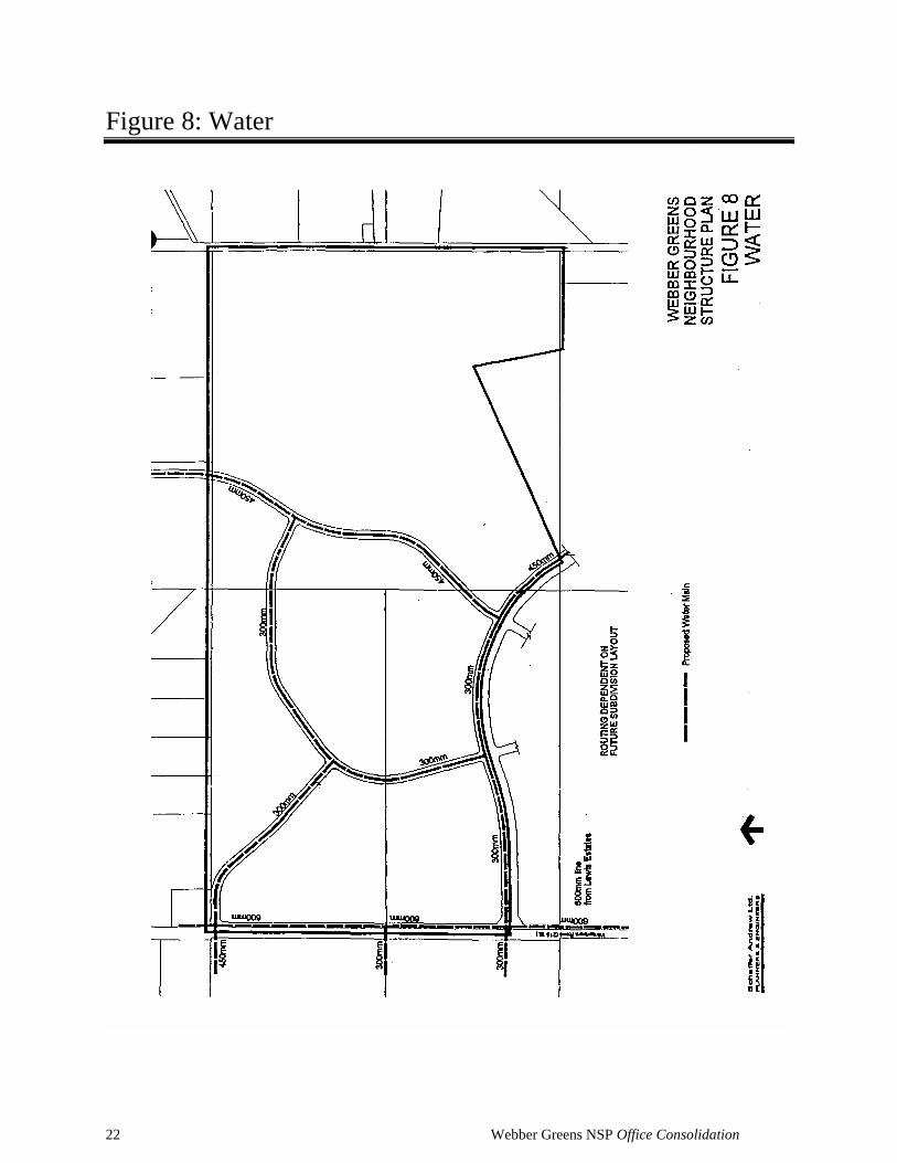
Figure 8: Water
23 Webber Greens NSP Office Consolidation
Chapter 5: Development Concept
5.1 Land Use The land use pattern proposed for Webber Greens Neighbourhood is shown in Figure 7.
A breakdown of the land use areas is shown in Table 1 Land Use Distribution.
5.1.1 Community Care The intent of the Community Center concept, as defined in the Lewis Farms Area
Structure Plan, is to provide a focal point that will serve to define Lewis Farms as a
distinct and identifiable community. The principal component is a shopping facility,
which can provide a full range of retailing and entertainment facilities typical of such a
centre. It may also include a limited amount of professional, financial and office
support services as well as certain community and public institutional uses (e.g. library,
health unit). A second major component of the Community Commercial are residential
uses. Higher density housing is proposed to be adjacent to the community shopping
centre and proximate to the district park. In Webber Greens, the Community Centre
area will consist of a Community Commercial and adjacent medium density uses. It is
located at the southwest corner of the Webber Greens NSP.
5.1.2 Residential The majority of the neighbourhood will be developed for low density residential uses.
Most medium density residential uses will be located within the Community Centre
boundary as indicated in Figure 7.
The location of the residential land uses has been modified to accommodate the
relocated stormwater management facilities, the revised school boundary and the
eliminated Neighbourhood Commercial land use.
The Webber Greens NSP contains five medium density residential sites. The 100 metre
resource facilities setback for development required around the well and battery sites
influences the location and development of three of these proposed medium density
residential sites.
One medium density residential site is incorporated into the east Plan area adjacent to
the Lewis Estates Golf Course and the stormwater management facility to take
advantage of the development benefits of these recreational facilities.
Bylaw 13662 April 7, 2004
Bylaw 13662 April 7, 2004
Bylaw 15365 February 17, 2010
24 Webber Greens NSP Office Consolidation
5.1.3 Schools/Parks The neighbourhood will include a separate elementary school, a public elementary
school, and a neighbourhood park. The existing public elementary/public junior high
school (Winterburn School) adjacent to the neighbourhood will continue to serve
outlying urban and rural areas in West Edmonton.
The 11.1 hectare central school/park site shown in Figure 7 provides ample frontage on
the collector for access and visibility. It is located near the centre of the neighbourhood
to minimise walking distances, and to ensure that two schools can be constructed such
that the City's minimum separation distance (100 metres) from well and battery sites can
be maintained.
Adequate frontage must be made available for a school bus drop zone along the south
side of Winterburn, School. To achieve this, the collector road may be slightly re-
aligned, and/or a small area of land may be added to the southeast corner of the school
site at the subdivision stage. If land is added to the site, it will hot receive municipal
reserve credit.
At the subdivision stage, front access to low density residential lots across from school
sites will be restricted. Where this occurs, alleys must be provided behind these lots to
provide alternative access. Low density development will be limited to the RF1 Single
Detached Residential District.
The school sites provided for in this plan reflect current standards of service. However,
changes in these standards may result in a reduced requirement for school sites in
Webber Greens. Should this occur, a portion of one or both of the school sites provided
(a public "K to 8" school at 5.7 ha, and 6 separate elementary school et 2.8 ha) may be
converted to alternate use.
5.1.4 Community Commercial
The Community Commercial area, as designated in the Development Concept, is
intended to accommodate a district level shopping centre that could include a range of
commercial land types as defined in the Lewis Farms Area Structure Plan.
The Community Commercial site at the intersection of Webber Greens Drive and
Winterburn Road (215 Street) is formally defined by registered roadways and contains
4.57 hectares.
Bylaw 13662 April 7, 2004
Bylaw 15365 February 17, 2010
25 Webber Greens NSP Office Consolidation
(Deleted Section 5.1.5 Convenience Commercial along Winterburn Road and the entrance to the neighbourhood, and renumbered the remaining sections accordingly) 5.1.5 Storm Water Management Following the original approval of the Webber Greens NSP, an updated drainage
assessment was conducted by AECOM Engineering Ltd. This investigation concluded
that a larger stormwater management facility would be required to accommodate
stormwater containment needs. A more appropriate site with lower lying lands was
identified for the stormwater management facility further east within the plan area. The
management facility has also been changed from a dry pond to a wet pond as per the
City of Edmonton requirements and preferences of Alberta Environment. Wet ponds
allow for waterborne particles to settle before proceeding into a natural waterway,
thereby separating contaminants from water systems. As a result of these changes, the
stormwater management facility has increased in size by 4.85 hectares for a total 6.25
hectares.
5.1.6 Resource Extraction Sites
The two resource extraction sites (the well lease area and the battery site) cannot be
developed for residential or residential related use at present. In addition, development
adjacent to these sites is restricted by City policy. However, these sites will eventually
be abandoned and become available for development. Future subdivision and servicing
design must provide for such development through the creation of "shadow plans”
acceptable to the City.
The neighbourhood profiles presented in Table 1 include these sites as part of the
developable area of the neighbourhood on the assumption that they will eventually be
abandoned and become developable.
5.2 Demography Table 1 provides a demographic profile of Webber Greens Neighbourhood. The
population and student generation figures provided are based on the land use areas and
on the most recent generation factors from the City of Edmonton Planning and
Development Department.
The overall density anticipated in Webber Greens Neighbourhood is approximately 41.0
people per gross developable hectare.
The student generation figures provided in Table 1 assume that students will attend a
Bylaw 15365 February 17, 2010
Bylaw 15365
February 17, 2010
Bylaw 13662 April 7, 2004
Bylaw 13662 April 7, 2004
Bylaw 13662 April 7, 2004
26 Webber Greens NSP Office Consolidation
three tier system of elementary, junior high, and high schools. However, it is possible
that a two tier system (kindergarten to grade eight, grade nine to grade 12) will be
implemented in Webber Greens Neighbourhood.
5.3 Transportation As per the amended area structure plan, access to Webber Greens Neighbourhood will
be available from Winterburn Road and 95 Avenue and via a collector connection to the
business/industrial area to the north. The Transportation Branch has indicated that the
Winterburn Road right-of-way must be widened by 12.0 metres. Figure 7 reflects this
widening.
An internal collector system will accommodate traffic movements within the
neighbourhood. Transit routing is subject to change over time. However, each collector
road will have the potential to be used as a bus route such that transit coverage
consistent with City of Edmonton policies can be provided. The collector road adjoining
Winterburn Road has been aligned to provide access to Winterburn School and creates
an intersection with a similar collector in Second Neighbourhood.
A system of pedestrian/cycle routes will be provided throughout the neighbourhood.
These will consist of a combination of exclusive walkways, sidewalks within road
rights-of-way, and pathways through public open spaces. The primary linkages are
shown conceptually in Figure 7. However, specific requirements in terms of location
and alignment can only be determined at the subdivision stage.
5.4 Utility Servicing The following is a brief overview of the servicing concepts for Webber Greens
Neighbourhood. These concepts are consistent with the Lewis Farms (North) Master
Drainage Plan Amendment (1999) which addressed required changes to the north
drainage basin in Lewis Farms. They are treated in more detail in the approved Water
Network Analysis and preliminary Neighbourhood Drainage Design Report for Webber
Greens.
5.4.1 Water As shown in Figure 8, water will be provided to the neighbourhood by a connection to
an existing main in Breckenridge Greens Neighbourhood to the south. The Connecting
600 mm line will utilise the Winterburn Road right-of-way. The water network for
Amended by Editor
27 Webber Greens NSP Office Consolidation
Webber Greens Neighbourhood will be looped within the neighbourhood as shown in
Figure 8.
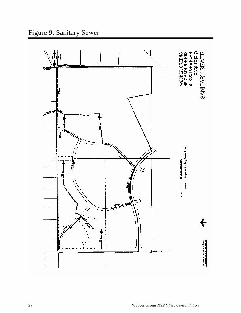
5.4.2 Sanitary Figure 9 shows the sanitary drainage concept. The sanitary sewer trunks will drain into
an underground sanitary lift station located to the west of Anthony Henday Drive,
approximately ½ mile south of Stony Plain Road, on land currently designated
industrial/business. Storage capacity will be provided upstream of the lift station in the
form of a holding tank and in-pipe storage.
The system within Webber Greens Neighbourhood will be oversized as necessary to
serve future development west of Winterburn Road.
(Deleted Section 5.4.3 Storm explaining the previously-approved storm sewer system for the neighbourhood and renumbered the remaining sections accordingly) 5.4.3 Shallow Utilities Telephone, power, cable, and gas will be extended from existing developed areas as
required to service this neighbourhood.
Bylaw 15365 February 17, 2010
28 Webber Greens NSP Office Consolidation
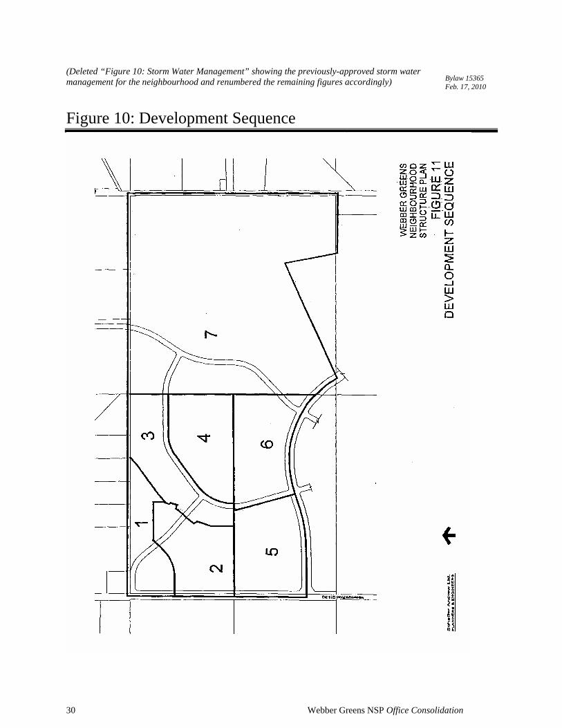
Chapter 6: Development Sequence Development is proposed to begin in the northwest comer of Webber Greens
Neighbourhood, as shown in Figure 11. Village Land Corporation, the beneficial owner,
is prepared to extend the utility services required for the development of this portion of
Webber Greens Neighbourhood from existing infrastructure east of the Lewis Farms
area. Access will be available from Winterburn Road, which will require upgrading to
serve this development. The stages 2, 3, and 4 will extend south and east to complete
the development of the northwest 32 ha of the neighbourhood.
Stage 5 is expected to commence in the southwest portion of the neighbourhood,
utilising access from Winterburn Road via the first stage of construction of 95 Avenue.
Services would be extended from the north. Stages 6 and 7 are proposed to develop
from west to east as services and access are extended.
Specific development proposals in various locations within the neighbourhood will be
evaluated on their merits.
29 Webber Greens NSP Office Consolidation
Figure 9: Sanitary Sewer
30 Webber Greens NSP Office Consolidation
(Deleted “Figure 10: Storm Water Management” showing the previously-approved storm water management for the neighbourhood and renumbered the remaining figures accordingly)
Figure 10: Development Sequence
Bylaw 15365 Feb. 17, 2010
31 Webber Greens NSP Office Consolidation
Chapter 7: Rationale This neighbourhood structure plan is generally consistent with the amended Lewis
Farms Area Structure Plan with respect to land use, transportation, and utility servicing
issues. However, the current area structure plan does not address the staging of
development beyond the first two neighbourhoods. Other than an acknowledgement that
a "secondary starting point for [industrial/business] development could be in the
northeast comer of the plan area", the current plan is not specific about the sequence of
development beyond the first few stages. In the current plan, residential development is
proposed to progress (as it has to date) west through Neighbourhood 1 (Potter Greens)
to Neighbourhood 2 (Breckenridge Greens). Development beyond these first two
neighbourhoods is referred to as "Future Stages" in Figure 11 Development Staging in
the current plan. There is no distinction made between one area and another in terms of
a preferred or anticipated residential development sequence. The plan only indicates that
future staging will be dependent on the economical extension of services. It is assumed
that staging will also be dependent on market demand.
The majority of Potter Greens and Breckenridge Greens Neighbourhoods is either
developed or subject to current subdivision approvals. It is now appropriate to provide
for a second starting point for residential development. The northeast corner of the plan
area is not a reasonable candidate. First, it is not designated for residential use. More
significantly, however, it is subject to serious access constraints not recognised in the
current area structure plan. Accesses at 204 Street and 199 Street are to be combined
into one central point of access that will be restricted to right in/right out turning
movements only. 95 Avenue may not continue west beyond Anthony Henday Drive to
support development in the northeast. If it does, it will end at 199 Street. 199 Street will
not extend to the south to Whitemud Drive. In addition, development in the northeast
area must overcome geotechnical constraints.
The only reasonable second starting point for residential development in Lewis Farms is
the area on either side of Winterburn Road, south of Stony Plain Road. This area has
several advantages:
• Access to the City's arterial road system is excellent via Winterburn and Stony Plain
Roads. Only the upgrading of Winterburn Road south from Stony Plain Road
would be required.
32 Webber Greens NSP Office Consolidation
• It is adjacent to existing residential development in Normandeau Gardens and
commercial and recreation development along the south side of Stony Plain Road.
• Winterburn School already exists at Winterburn Road just south of Stony Plain
Road.
• Residential development at this location will support the extension of municipal
services to the Normandeau Gardens area. This will in turn support either the
redevelopment of the area for industrial/business, as called for by the current area
structure plan, or the consolidation, as some residents have suggested, of its status
as a residential development.
• The extension of services to Webber Greens Neighbourhood will also support the
development of the industrial/business employment areas immediately to the north
and northeast.
• Playgrounds and sports fields already exist at Winterburn School and on City owned
land across Winterburn Road.
• The majority of Neighbourhood 3 can be accommodated through the existing
drainage basin, but Neighbourhood 3 cannot be fully developed until utility services
are extended from the northeast. Development in Webber Greens requires the
extension of these services, which are also required for the completion of
Neighbourhood 3.
As discussed in Section 5.4, residential development in Webber Greens Neighbourhood
at Winterburn Road will require the extension of sewer services from the east and south.
The Municipal water supply will be extended north from Breckenridge Greens. The
developer will bear the servicing costs in accordance with normal development
practices.