Weather Warning: Britain’s Special Places Under...
41
Weather Warning: Britain’s Special Places Under Threat showthelove.org.uk #ShowTheLove
-
Upload
truongtruc -
Category
Documents
-
view
228 -
download
3
Transcript of Weather Warning: Britain’s Special Places Under...
Weather Warning: Britain’s Special Places Under Threat
showthelove.org.uk#ShowTheLove
showthelove.org.uk#ShowTheLove
This report has been researched and written by The Climate Coalition with support, analysis and weather attribution by the Priestley International Centre for Climate.
The Climate Coalition
The Climate Coalition is the UK’s largest group of people dedicated to action on climate change and limiting its impact on the people, places and life we love at home in the UK and around the world, including the world’s poorest countries. It includes over 130 organisations with a combined supporter base of 15 million. Together, we want a world powered by clean and secure energy within a generation.
Priestley International Centre for Climate
Providing research to underpin robust and timely climate solutions is the USP of the PriestleyInternational Centre for Climate. The University of Leeds centre is unique in bringing together world leading expertise in all the key strands of climate change research. One of the University’s flagship strategic investments, the Priestley Centre aims to provide international solutions to the global chal-lenge of climate change through new interdisciplinary research partnerships that better link our physi-cal, technological, economic and social understanding of climate change with strategies for mitigation and adaptation. Find out more at climate.leeds.ac.uk
Cover Photo: Beckmickle Ing Woodland in Cumbria
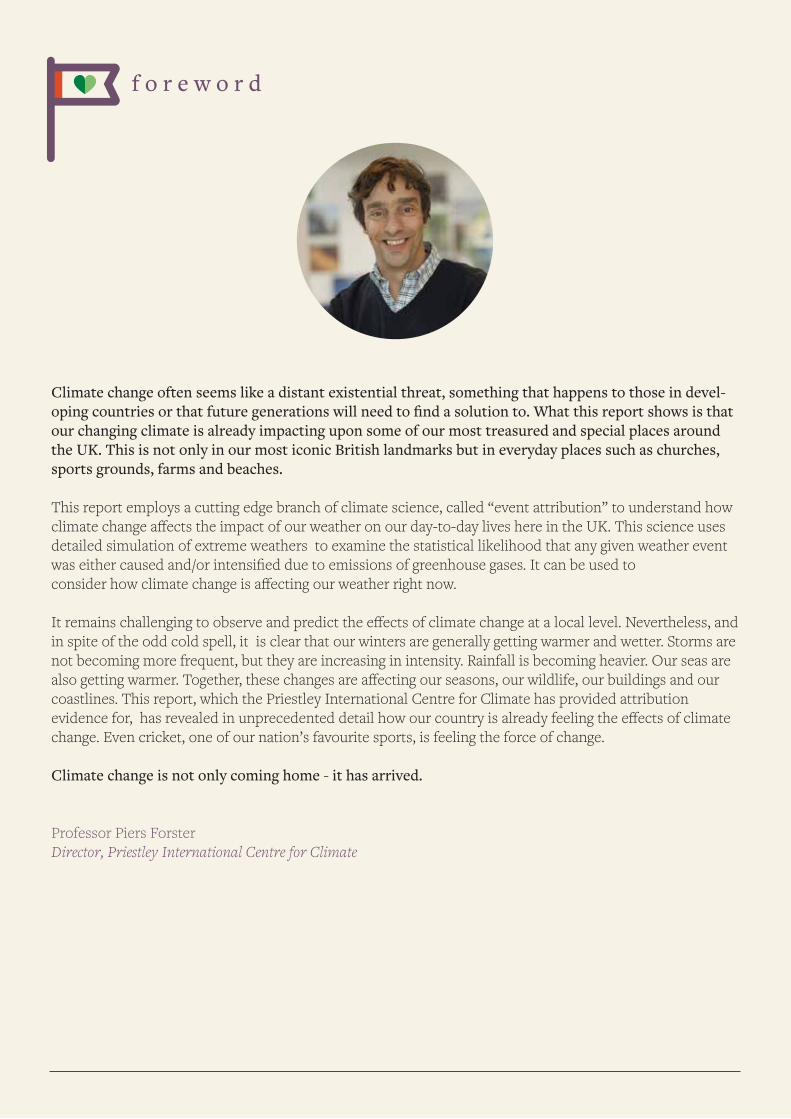
f o r e w o r d
Climate change often seems like a distant existential threat, something that happens to those in devel-oping countries or that future generations will need to find a solution to. What this report shows is that our changing climate is already impacting upon some of our most treasured and special places around the UK. This is not only in our most iconic British landmarks but in everyday places such as churches, sports grounds, farms and beaches.
This report employs a cutting edge branch of climate science, called “event attribution” to understand how climate change affects the impact of our weather on our day-to-day lives here in the UK. This science uses detailed simulation of extreme weathers to examine the statistical likelihood that any given weather event was either caused and/or intensified due to emissions of greenhouse gases. It can be used to consider how climate change is affecting our weather right now.
It remains challenging to observe and predict the effects of climate change at a local level. Nevertheless, and in spite of the odd cold spell, it is clear that our winters are generally getting warmer and wetter. Storms are not becoming more frequent, but they are increasing in intensity. Rainfall is becoming heavier. Our seas are also getting warmer. Together, these changes are affecting our seasons, our wildlife, our buildings and our coastlines. This report, which the Priestley International Centre for Climate has provided attribution evidence for, has revealed in unprecedented detail how our country is already feeling the effects of climate change. Even cricket, one of our nation’s favourite sports, is feeling the force of change.
Climate change is not only coming home - it has arrived.
Professor Piers ForsterDirector, Priestley International Centre for Climate
i n t r o d u c t i o n
There are many things to be proud of in Britain and much about our country that we love dearly - our landscapes, our culture, our communities, our nature, our sporting traditions, our faiths, our heritage. Our relationships to all these things are often rooted in particular places that are dear to us – the local pub, the village cricket pitch, a coastal path, the parish church, a neighbouring farm or nearby woodland. These are the places where we live, work and play, where we pause, breathe and dream - and where many of our personal, familial and collective memories are made.
In recent years, some of these very special places have been damaged by extreme weather, in particular heavy rainfall and flooding. The British weather has always been changeable, but there is now a proven increase in extreme weather events and scientists have calculated that climate change is playing a role.
beautiful things are possible
The Climate Coalition has been working with a range of local businesses, communities, organisations and institutions across Britain to document how recent extreme weather, and changes in our weather patterns, are affecting their special places, and what this has cost them - and us - financially and otherwise.
In and around each of these places there are people – residents, staff, families, communities, supporters and visitors – whose lives are that bit harder or poorer because of the damage their special place has sustained.This report compiles a series of case studies of 12 special places, landscapes and buildings that have been damaged by warmer, wetter weather and severe flooding – in some cases irrevocably.
We have teamed up with The Priestley International Centre for Climate at the University of Leeds to under-stand the evidence that the extreme weathers we are seeing are a likely result of human activities, such as the use of fossil fuels. They provided scientific sources to substantiate the links between the damage created to these special places and our changing climate.
We - The Climate Coalition of over 130 charities including The RSPB, Woodland Trust, National Trust, Christian Aid, WWF-UK, Oxfam and The Women’s Institute - are working together to tackle climate change. We want to do all we can to protect the places, people and life we love from our chang-ing climate.
This report marks the launch of the annual Show The Love campaign which aims to raise awareness of climate change and all it threatens, and encourage people to show their support for action toaddress it.
This report sits alongside a very special short film - Love Song - that connects people to these stories. This can be seen in Picturehouse Cinemas from 10th-17th February, or found on showthelove.org.uk
c o n t e n t s
1. Foreword
2. Introduction
3. Case Studies: Britain's Special Places Under Threat
Birling Gap Cliffs, East Sussex
Church of the Good Shepherd, West Yorkshire
Manor Farm, East Yorkshire
Slimbridge Wetland Centre, Gloucestershire
The Mark Addy Pub, Lancashire
Wordsworth House and Gardens, Cumbria
Beckmickle Ing Woodlands, Cumbria
Corbridge Cricket Club, Northumberland
Plas Cadnant Hidden Gardens, Anglesey
Skara Brae World Heritage Site, Orkney
River Usk & Wye, Wales and West Midlands
Youth Hostel Association Keswick, Cumbria
4. Conclusion
5. Reasons to be Hopeful
6. References
b i r l i n g g a p east sussex
An area of outstanding beauty, near Eastbourne in East Sussex, Birling Gap is part of the world famous Seven Sisters chalk cliffs, where sweeping downland meets sheer chalk cliffs.
Due to the geology of the coastline soft chalk deposits in the valley have, over time, seen steady levels of erosion. Using monitoring data collected over the past 50 years, the cliffs lost about 67cm each year.
However, over recent years the speed of erosion at Birling Gap, which welcomes over 250,000 visitors each year, has increased. During the winter storms of 2013/4 the equivalent of seven years of erosion took place in just two months as a result of a combination of climate change and an increase in the regularity of storm events during this period.
After the storms, The National Trust, which owns the land, found their visitor centre, sun lounge area and ice cream parlour just five metres from the cliff edge so were forced to take them down. At the current rate of erosion, it has been estimated that the Birling Gap Hotel will begin to topple off the edge of the cliff in 40 years time [1]. In fact, the land beneath the hotel will all have vanished completely in 93 years according to projections [1].
adapting to climate change
The National Trust has named Birling Gap as one of its ‘coastal hotspots’ at risk of climate change [2]. As the cliff line continues to erode the Trust is adapting to the pace of change, investing in ‘elephants feet’ fencing which can be moved backwards as the cliff continues to crumble, in order to help manage the added danger of falling fences.
The steps down to the beach are another feature which enables Birling Gap to adapt to the coastal change. The horizontal gangway that leads to the steps not only gives a platform for great views along the coast but can be extended and the whole step structure can be moved and repositioned higher up the beach as the cliffs retreat.
The longer term plan at Birling Gap is to roll-back the infrastructure within the site to a location that is less at risk of coastal erosion.
Phil Dyke, National Trust coastal adviser, said: “The succession of storms that impacted our coastlines during 2013 and 2014 provided a stark warning that coastal ‘defence’ as the only response to managing coastal change looks increasingly less plausible. As we are doing at Birling Gap we must learn how to adapt and take a long term view.”
what the science tells us
The impacts on this part of the coastline are twofold. Firstly, sea levels are rising, and using climate model-ling, experts predict that they will continue to rise in the future [3, 43]. This, coupled with more intense storms and increases in intense rainfall, will be likely to increase the rate of erosion compared with that of the last 100 years, making incidences such as this, more common.
Studies have also shown that increasing sea-level is driven by climate change, [4] and storm surges are there-fore more likely to erode cliffs. Given the geographical position of Birling Gap, those helping to manage the area have no choice but to try and adapt to minimise the impact on this beautiful stretch of the South East coastline.
“As sea levels rise and storminess increases the erosion could accelerate and parts of our building will continue to be lost.
We’re working with coastal change, closing and taking down some of the original parts of the building and plan to move ‘backwards’ through the rooms so that what is today a learning space may become the café in the future. Any new building will be designed to be simpler and more modular so that it can be more easily taken down and re-built. That way we can stay ahead of the eroding cliff line.”
Phil Dyke, National Trust coastal adviser
c h u r c h o f t h e g o o d s h e p h e r d mytholmroyd, west yorkshire
The Church of the Good Shepherd in the village of Mytholmroyd, West Yorkshire, sits in the Calder Valley which runs to the border with Lancashire. The area has been prone to flooding in the past, with both Mytholmroyd and the nearby town of Hebden Bridge experiencing flash floods in July 2012.
anniversary celebrations
The Church of the Good Shepherd celebrated its 25th anniversary with a complete refurbishment and was reopened on the 27th November 2015. One month later the flood sirens sounded along the valley as the River Calder broke its banks due to intense rainfall over Christmas Day and Boxing Day.
As the river and adjacent canal banks were breached, the water made its way towards the car park in front of the church then into the place of worship itself, which had never before been flooded.
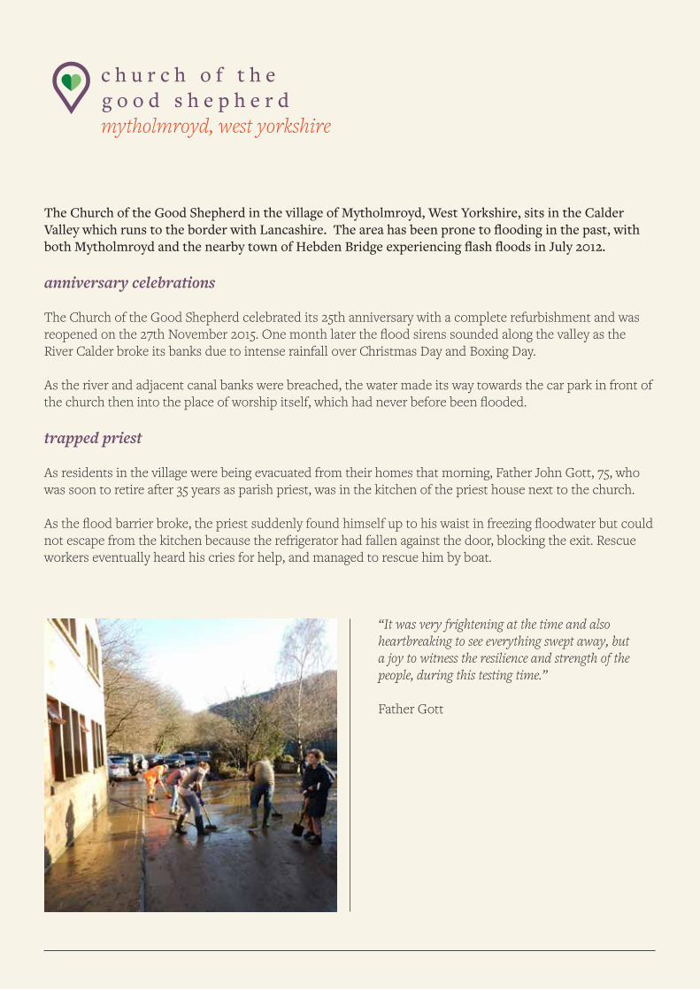
trapped priest
As residents in the village were being evacuated from their homes that morning, Father John Gott, 75, who was soon to retire after 35 years as parish priest, was in the kitchen of the priest house next to the church. As the flood barrier broke, the priest suddenly found himself up to his waist in freezing floodwater but could not escape from the kitchen because the refrigerator had fallen against the door, blocking the exit. Rescue workers eventually heard his cries for help, and managed to rescue him by boat.
“It was very frightening at the time and also heartbreaking to see everything swept away, but a joy to witness the resilience and strength of the people, during this testing time.”
Father Gott
the cost
It took nine months to repair the damage to the church forcing the congregation to move to a nearby Meth-odist Church for mass. Eighty per cent of town centre shops in Hebden Bridge including, cafes, pubs, and 100 businesses in Mytholmroyd were affected by the flood. By the following April, just 61% of Hebden Bridge businesses had reopened. It was estimated that businesses across Calderdale lost £47 million as a result of the Boxing Day floods.
what the science tells us
The flood waters which affected the Calderdale Valley were caused by a period of sustained heavy rainfall on Christmas and Boxing Day 2015.
Researchers, who have studied seasonal weather patterns over the last 100 years, have shown that the UK is experiencing more intense heavy rainfall during Winter, and to some extent during Spring and Autumn. [5a, 5b]. The UK Met Office said that the winter of 2015/2016 was the second wettest since records began in 1910, having ‘record-rainfall totals’ accompanied by ‘exceptional warmth’. [6]. December saw between two and four times the monthly average rainfall across much of the west and north, and this was the wettest calen-dar month of the year [6]. This upward trend towards more intense bursts of rainfall which can cause flooding, is set to continue.
Using a range of climate modelling techniques, scientists say that the increase in periods of heavy rainfall and overall rainfall amounts can be linked to man-made emissions [7].
In a recent climate modelling study researchers found that climate change made the UK’s record December rainfall in 2015, which caused the devastating floods, 50-75% more likely [44].
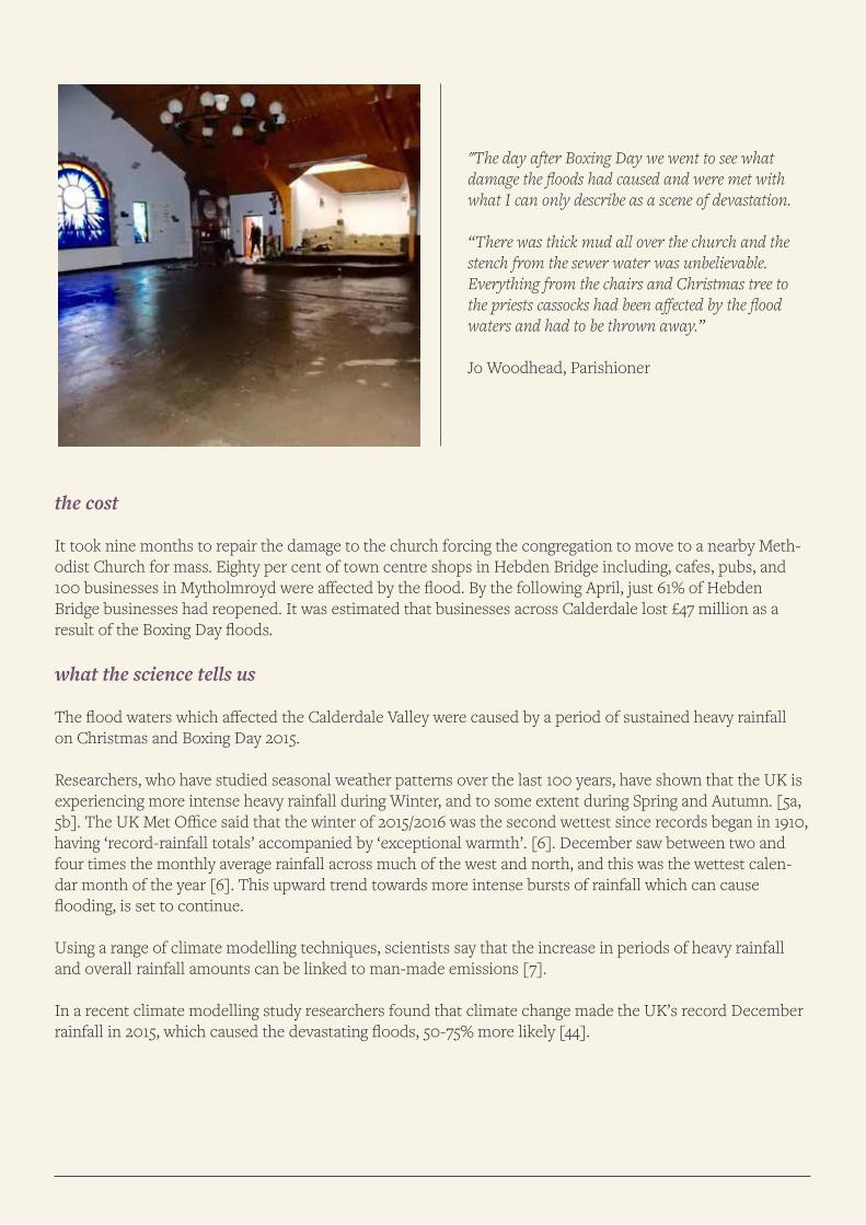
"The day after Boxing Day we went to see what damage the floods had caused and were met with what I can only describe as a scene of devastation.
“There was thick mud all over the church and the stench from the sewer water was unbelievable. Everything from the chairs and Christmas tree to the priests cassocks had been affected by the flood waters and had to be thrown away.”
Jo Woodhead, Parishioner
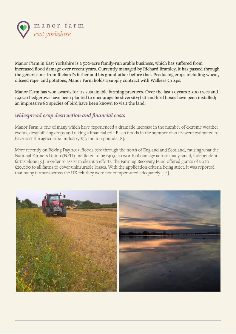
m a n o r f a r m east yorkshire
Manor Farm in East Yorkshire is a 500-acre family-run arable business, which has suffered from increased flood damage over recent years. Currently managed by Richard Bramley, it has passed through the generations from Richard’s father and his grandfather before that. Producing crops including wheat, oilseed rape and potatoes, Manor Farm holds a supply contract with Walkers Crisps.
Manor Farm has won awards for its sustainable farming practices. Over the last 15 years 2,500 trees and 12,000 hedgerows have been planted to encourage biodiversity; bat and bird boxes have been installed; an impressive 80 species of bird have been known to visit the land.
widespread crop destruction and financial costs
Manor Farm is one of many which have experienced a dramatic increase in the number of extreme weather events, destabilising crops and taking a financial toll. Flash floods in the summer of 2007 were estimated to have cost the agricultural industry £50 million pounds [8].
More recently on Boxing Day 2015, floods tore through the north of England and Scotland, causing what the National Farmers Union (NFU) predicted to be £40,000 worth of damage across many small, independent farms alone [9] In order to assist in cleanup efforts, the Farming Recovery Fund offered grants of up to £20,000 to all farms to cover uninsurable losses. With the application criteria being strict, it was reported that many farmers across the UK felt they were not compensated adequately [10].
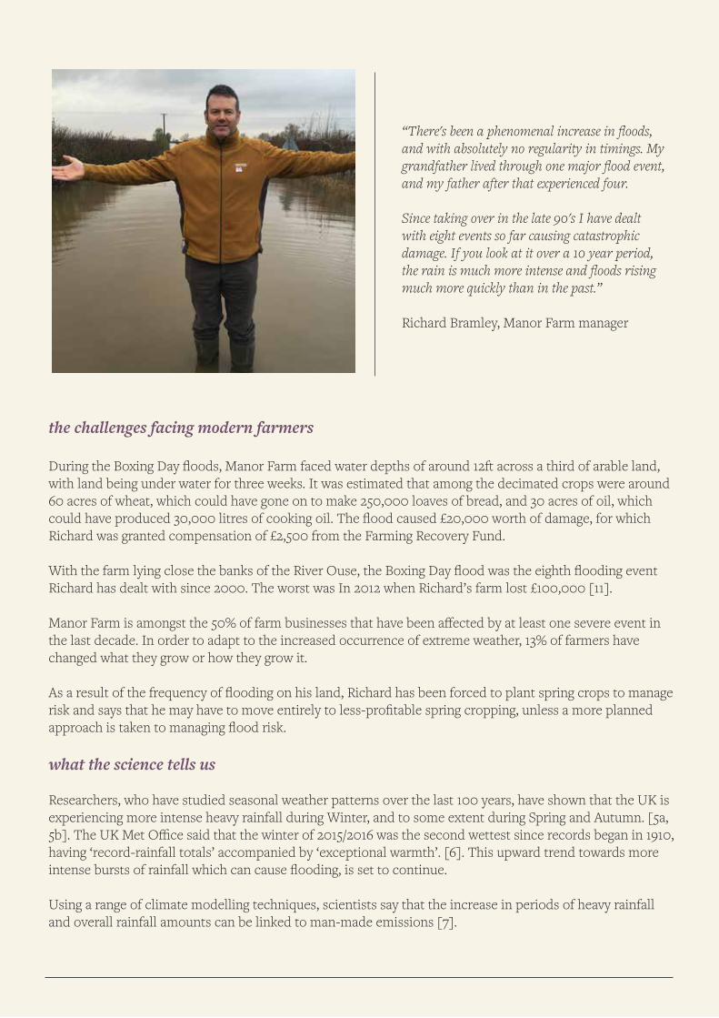
the challenges facing modern farmers
During the Boxing Day floods, Manor Farm faced water depths of around 12ft across a third of arable land, with land being under water for three weeks. It was estimated that among the decimated crops were around 60 acres of wheat, which could have gone on to make 250,000 loaves of bread, and 30 acres of oil, which could have produced 30,000 litres of cooking oil. The flood caused £20,000 worth of damage, for which Richard was granted compensation of £2,500 from the Farming Recovery Fund.
With the farm lying close the banks of the River Ouse, the Boxing Day flood was the eighth flooding event Richard has dealt with since 2000. The worst was In 2012 when Richard’s farm lost £100,000 [11].
Manor Farm is amongst the 50% of farm businesses that have been affected by at least one severe event in the last decade. In order to adapt to the increased occurrence of extreme weather, 13% of farmers have changed what they grow or how they grow it.
As a result of the frequency of flooding on his land, Richard has been forced to plant spring crops to manage risk and says that he may have to move entirely to less-profitable spring cropping, unless a more planned approach is taken to managing flood risk.
what the science tells us
Researchers, who have studied seasonal weather patterns over the last 100 years, have shown that the UK is experiencing more intense heavy rainfall during Winter, and to some extent during Spring and Autumn. [5a, 5b]. The UK Met Office said that the winter of 2015/2016 was the second wettest since records began in 1910, having ‘record-rainfall totals’ accompanied by ‘exceptional warmth’. [6]. This upward trend towards more intense bursts of rainfall which can cause flooding, is set to continue.
Using a range of climate modelling techniques, scientists say that the increase in periods of heavy rainfall and overall rainfall amounts can be linked to man-made emissions [7].
“There's been a phenomenal increase in floods, and with absolutely no regularity in timings. My grandfather lived through one major flood event, and my father after that experienced four.
Since taking over in the late 90's I have dealt with eight events so far causing catastrophic damage. If you look at it over a 10 year period, the rain is much more intense and floods rising much more quickly than in the past.”
Richard Bramley, Manor Farm manager
s l i m b r i d g e w e t l a n d c e n t r e gloucestershire
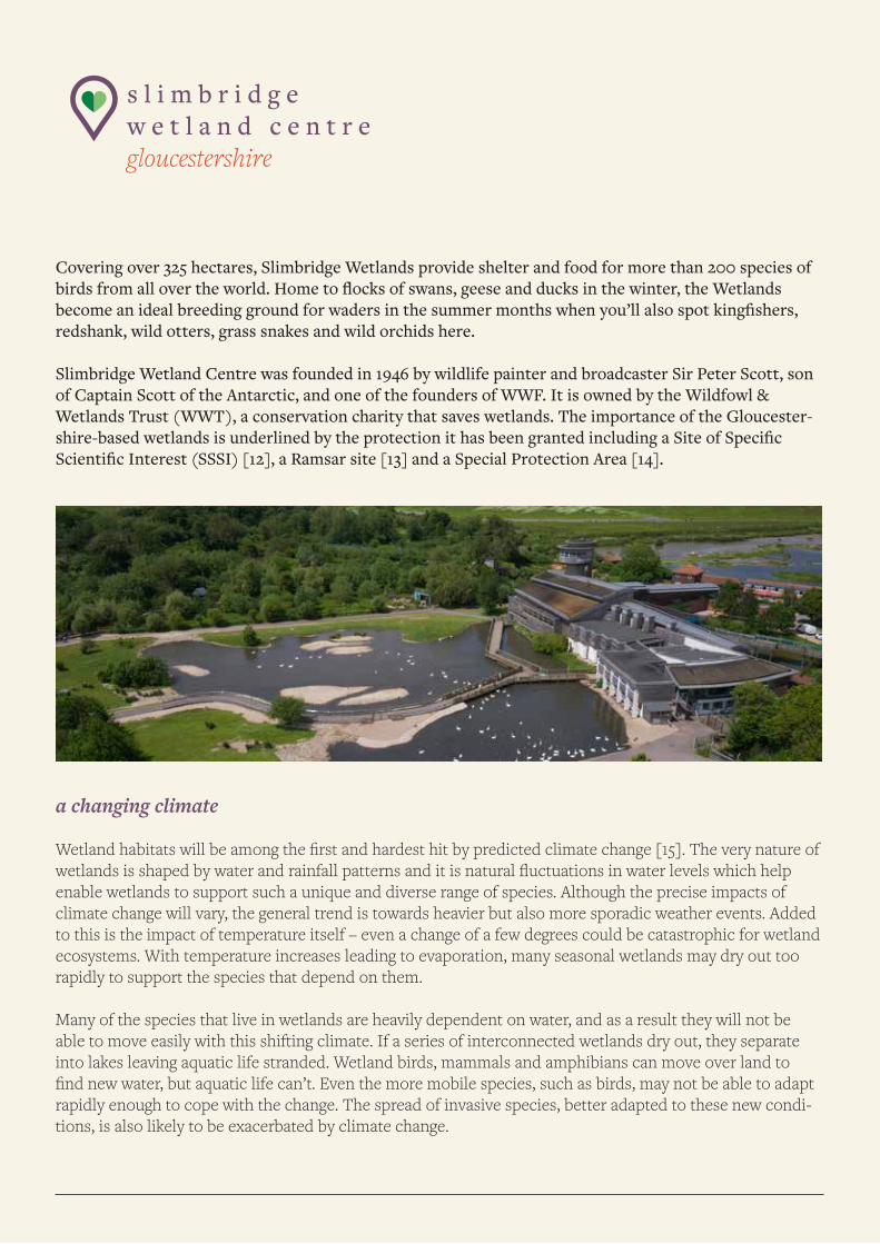
Covering over 325 hectares, Slimbridge Wetlands provide shelter and food for more than 200 species of birds from all over the world. Home to flocks of swans, geese and ducks in the winter, the Wetlands become an ideal breeding ground for waders in the summer months when you’ll also spot kingfishers, redshank, wild otters, grass snakes and wild orchids here.
Slimbridge Wetland Centre was founded in 1946 by wildlife painter and broadcaster Sir Peter Scott, son of Captain Scott of the Antarctic, and one of the founders of WWF. It is owned by the Wildfowl & Wetlands Trust (WWT), a conservation charity that saves wetlands. The importance of the Gloucester-shire-based wetlands is underlined by the protection it has been granted including a Site of Specific Scientific Interest (SSSI) [12], a Ramsar site [13] and a Special Protection Area [14].
a changing climate
Wetland habitats will be among the first and hardest hit by predicted climate change [15]. The very nature of wetlands is shaped by water and rainfall patterns and it is natural fluctuations in water levels which help enable wetlands to support such a unique and diverse range of species. Although the precise impacts of climate change will vary, the general trend is towards heavier but also more sporadic weather events. Added to this is the impact of temperature itself – even a change of a few degrees could be catastrophic for wetland ecosystems. With temperature increases leading to evaporation, many seasonal wetlands may dry out too rapidly to support the species that depend on them.
Many of the species that live in wetlands are heavily dependent on water, and as a result they will not be able to move easily with this shifting climate. If a series of interconnected wetlands dry out, they separate into lakes leaving aquatic life stranded. Wetland birds, mammals and amphibians can move over land to find new water, but aquatic life can’t. Even the more mobile species, such as birds, may not be able to adapt rapidly enough to cope with the change. The spread of invasive species, better adapted to these new condi-tions, is also likely to be exacerbated by climate change.
changing migration patterns
The WWT says that numbers of some very familiar species are decreasing in the UK, as many migratory birds do not fly as far due to changes in seasonal weather. Studies have found that geese, ducks and swans that spend winter in the wetlands of Northern Europe are changing their migration patterns as temperatures rise. Some waterfowl delayed migrations by up to a month compared with 30 years ago, researchers found in 2012 [16]. Six species out of the 15 in the study set off significantly later; these included some traditional UK winter visitors such as the greylag goose and the tufted duck.
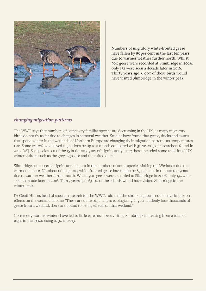
Slimbridge has reported significant changes in the numbers of some species visiting the Wetlands due to a warmer climate. Numbers of migratory white-fronted geese have fallen by 85 per cent in the last ten years due to warmer weather further north. Whilst 900 geese were recorded at Slimbridge in 2006, only 132 were seen a decade later in 2016. Thirty years ago, 6,000 of these birds would have visited Slimbridge in the winter peak.
Dr Geoff Hilton, head of species research for the WWT, said that the shrinking flocks could have knock-on effects on the wetland habitat: "These are quite big changes ecologically. If you suddenly lose thousands of geese from a wetland, there are bound to be big effects on that wetland."
Conversely warmer winters have led to little egret numbers visiting Slimbridge increasing from a total of eight in the 1990s rising to 30 in 2013.
Numbers of migratory white-fronted geese have fallen by 85 per cent in the last ten years due to warmer weather further north. Whilst 900 geese were recorded at Slimbridge in 2006, only 132 were seen a decade later in 2016. Thirty years ago, 6,000 of these birds would have visited Slimbridge in the winter peak.
rise of invasive species
Asian Zebra Mussels, a small freshwater mussel which breeds prolifically, are the most troublesome non-na-tive invasive species at Slimbridge. The mussels form vast colonies on hard surfaces that block water pipes, which workers regularly have to clear at the Wetlands. Studies have found that weather events, such as storms, act like a cocktail shaker and mix up the water layers, bringing fresh supplies of phytoplankton for the mussels to feed on which encourages them to multiply.
Warmer conditions mean non-native water primrose has grown aggressively in wide, dense mats taking up light, oxygen and space and having a serious impact on native plants, invertebrates and fish, according to studies by Natural England.
what the science tells us
Studies have shown that migrating birds are responding to the effects of climate change by arriving at their summer breeding grounds earlier with an increasing global temperature. The study looked at hundreds of species across five continents. The main reason birds take flight is changing seasonal temperatures and food availability [18].
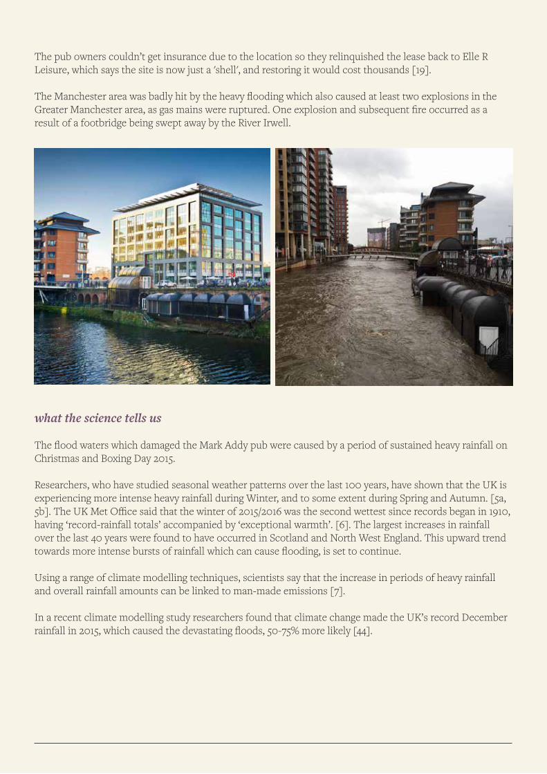
m a r k a d d y p u b manchester
An iconic riverside pub on Manchester's river Irwell, has never re-opened after floods caused around £200,000 worth of damage.
The Salford pub, which opened on the site of a passenger boat landing stage in 1980, became one of the area’s biggest and busiest pubs. The pub became famous for its unique, domed entrance and bay windows which jut out of the rear wall to overhang the river. The old wall is part of what was the New Bailey Prison, and dates from 1787. It was named after the Salford champion oarsman, swimmer and publican who saved 50 people from drowning in the Irwell, and was presented with a medal for bravery by Queen Victoria.
a scene of destruction
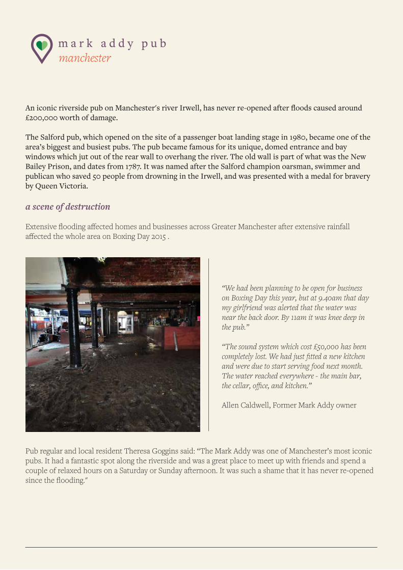
Extensive flooding affected homes and businesses across Greater Manchester after extensive rainfall affected the whole area on Boxing Day 2015 .
Pub regular and local resident Theresa Goggins said: “The Mark Addy was one of Manchester’s most iconic pubs. It had a fantastic spot along the riverside and was a great place to meet up with friends and spend a couple of relaxed hours on a Saturday or Sunday afternoon. It was such a shame that it has never re-opened since the flooding."
“We had been planning to be open for business on Boxing Day this year, but at 9.40am that day my girlfriend was alerted that the water was near the back door. By 11am it was knee deep in the pub.”
“The sound system which cost £50,000 has been completely lost. We had just fitted a new kitchen and were due to start serving food next month. The water reached everywhere - the main bar, the cellar, office, and kitchen.”
Allen Caldwell, Former Mark Addy owner
The pub owners couldn’t get insurance due to the location so they relinquished the lease back to Elle R Leisure, which says the site is now just a 'shell', and restoring it would cost thousands [19].
The Manchester area was badly hit by the heavy flooding which also caused at least two explosions in the Greater Manchester area, as gas mains were ruptured. One explosion and subsequent fire occurred as a result of a footbridge being swept away by the River Irwell.
what the science tells us
The flood waters which damaged the Mark Addy pub were caused by a period of sustained heavy rainfall on Christmas and Boxing Day 2015.
Researchers, who have studied seasonal weather patterns over the last 100 years, have shown that the UK is experiencing more intense heavy rainfall during Winter, and to some extent during Spring and Autumn. [5a, 5b]. The UK Met Office said that the winter of 2015/2016 was the second wettest since records began in 1910, having ‘record-rainfall totals’ accompanied by ‘exceptional warmth’. [6]. The largest increases in rainfall over the last 40 years were found to have occurred in Scotland and North West England. This upward trend towards more intense bursts of rainfall which can cause flooding, is set to continue.
Using a range of climate modelling techniques, scientists say that the increase in periods of heavy rainfall and overall rainfall amounts can be linked to man-made emissions [7].
In a recent climate modelling study researchers found that climate change made the UK’s record December rainfall in 2015, which caused the devastating floods, 50-75% more likely [44].
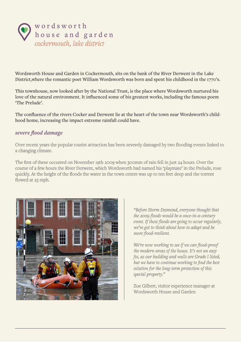
w o r d s w o r t h h o u s e a n d g a r d e n cockermouth, lake district
Wordsworth House and Garden in Cockermouth, sits on the bank of the River Derwent in the Lake District,where the romantic poet William Wordsworth was born and spent his childhood in the 1770’s.
This townhouse, now looked after by the National Trust, is the place where Wordsworth nurtured his love of the natural environment. It influenced some of his greatest works, including the famous poem ‘The Prelude’.
The confluence of the rivers Cocker and Derwent lie at the heart of the town near Wordsworth’s child-hood home, increasing the impact extreme rainfall could have.
severe flood damage
Over recent years the popular tourist attraction has been severely damaged by two flooding events linked to a changing climate. The first of these occurred on November 19th 2009 when 300mm of rain fell in just 24 hours. Over the course of a few hours the River Derwent, which Wordsworth had named his ‘playmate’ in the Prelude, rose quickly. At the height of the floods the water in the town centre was up to ten feet deep and the torrent flowed at 25 mph.
“Before Storm Desmond, everyone thought that the 2009 floods would be a once-in-a-century event. If these floods are going to occur regularly, we’ve got to think about how to adapt and be more flood-resilient.
We’re now working to see if we can flood-proof the modern areas of the house. It’s not an easy fix, as our building and walls are Grade I listed, but we have to continue working to find the best solution for the long-term protection of this special property.”
Zoe Gilbert, visitor experience manager at Wordsworth House and Garden
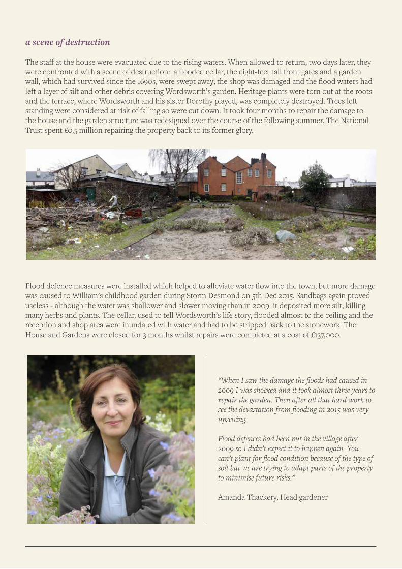
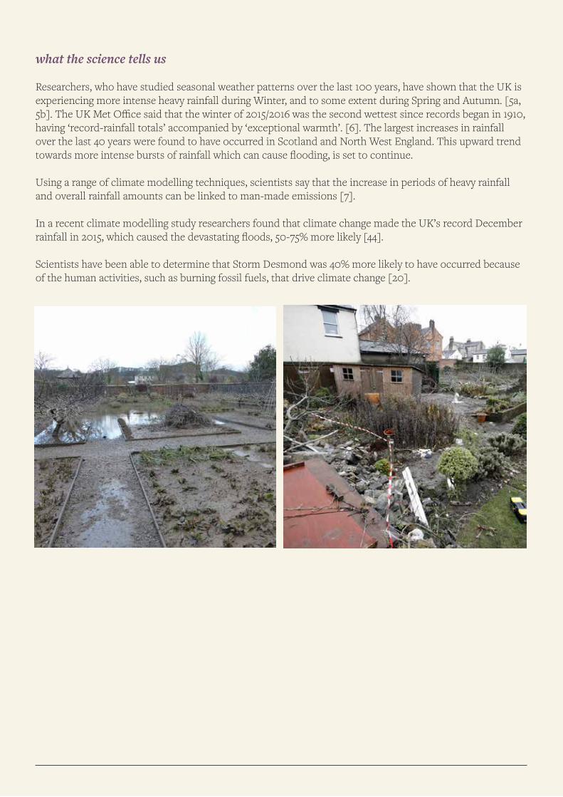
a scene of destruction
The staff at the house were evacuated due to the rising waters. When allowed to return, two days later, they were confronted with a scene of destruction: a flooded cellar, the eight-feet tall front gates and a garden wall, which had survived since the 1690s, were swept away; the shop was damaged and the flood waters had left a layer of silt and other debris covering Wordsworth’s garden. Heritage plants were torn out at the roots and the terrace, where Wordsworth and his sister Dorothy played, was completely destroyed. Trees left standing were considered at risk of falling so were cut down. It took four months to repair the damage to the house and the garden structure was redesigned over the course of the following summer. The National Trust spent £0.5 million repairing the property back to its former glory.
.
Flood defence measures were installed which helped to alleviate water flow into the town, but more damage was caused to William’s childhood garden during Storm Desmond on 5th Dec 2015. Sandbags again proved useless - although the water was shallower and slower moving than in 2009 it deposited more silt, killing many herbs and plants. The cellar, used to tell Wordsworth’s life story, flooded almost to the ceiling and the reception and shop area were inundated with water and had to be stripped back to the stonework. The House and Gardens were closed for 3 months whilst repairs were completed at a cost of £137,000.
“When I saw the damage the floods had caused in 2009 I was shocked and it took almost three years to repair the garden. Then after all that hard work to see the devastation from flooding in 2015 was very upsetting.
Flood defences had been put in the village after 2009 so I didn’t expect it to happen again. You can’t plant for flood condition because of the type of soil but we are trying to adapt parts of the property to minimise future risks.”
Amanda Thackery, Head gardener
what the science tells us
Researchers, who have studied seasonal weather patterns over the last 100 years, have shown that the UK is experiencing more intense heavy rainfall during Winter, and to some extent during Spring and Autumn. [5a, 5b]. The UK Met Office said that the winter of 2015/2016 was the second wettest since records began in 1910, having ‘record-rainfall totals’ accompanied by ‘exceptional warmth’. [6]. The largest increases in rainfall over the last 40 years were found to have occurred in Scotland and North West England. This upward trend towards more intense bursts of rainfall which can cause flooding, is set to continue.
Using a range of climate modelling techniques, scientists say that the increase in periods of heavy rainfall and overall rainfall amounts can be linked to man-made emissions [7].
In a recent climate modelling study researchers found that climate change made the UK’s record December rainfall in 2015, which caused the devastating floods, 50-75% more likely [44].
Scientists have been able to determine that Storm Desmond was 40% more likely to have occurred because of the human activities, such as burning fossil fuels, that drive climate change [20].
b e c k m i c k l e i n g w o o d l a n d s cumbria
An ancient woodland which is just a stone’s throw away from the Lake District National Park, Beckmickle Ing is a very special place indeed. Home to roe deer and red squirrel, the wood sits on the bank of the River Kent a few miles from Kendal. Owned and managed by the Woodland Trust, Beckmickle Ing has been designated a Site of Special Scientific Interest and as a Special Area of Conservation. The River Kent and its tributaries support a range of important wildlife including white clawed crayfish and freshwater peak mussels.
flood waters surge through the ancient woodland
The whole of Cumbria was very badly affected by storms and heavy rainfall which hit the UK during the winter of 2015-2016. During the first week of December 2015, the Met Office recorded record rainfall totals across Cumbria, 2 to 4 times the average in the west and north [21]. The extensive rainfall created widespread flooding across Cumbria, affecting road and rail links as well as communities including Keswick, Kendal, Cockermouth and Carlisle, and washing several bridges away completely. It was against this backdrop that the Woodland Trust found Beckmickle Ing under siege from flooding and flood impacts throughout the month of December.
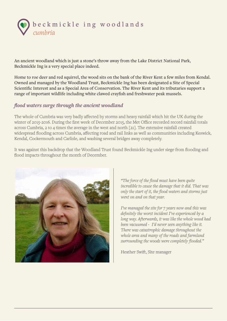
“The force of the flood must have been quite incredible to cause the damage that it did. That was only the start of it, the flood waters and storms just went on and on that year.
I’ve managed the site for 7 years now and this was definitely the worst incident I’ve experienced by a long way. Afterwards, it was like the whole wood had been vacuumed - I’d never seen anything like it. There was catastrophic damage throughout the whole area and many of the roads and farmland surrounding the woods were completely flooded.”
Heather Swift, Site manager
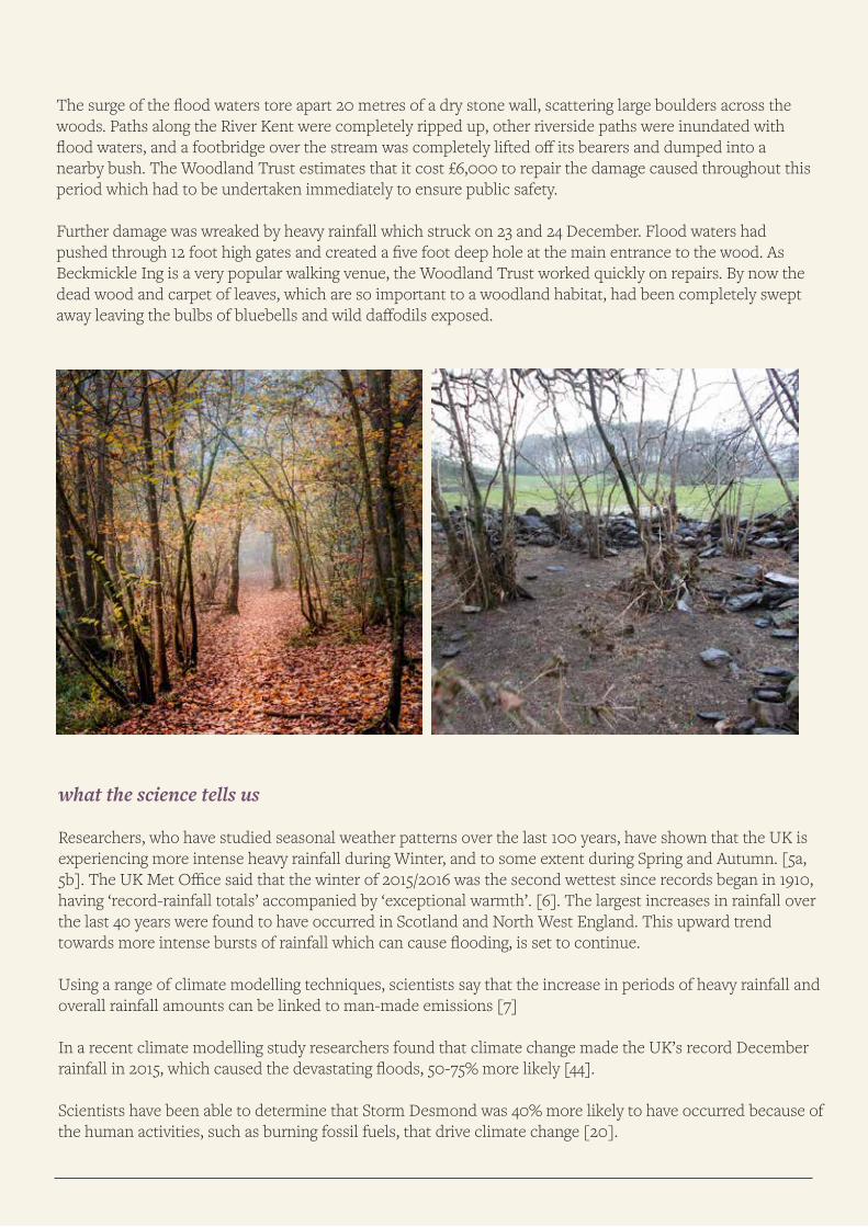
The surge of the flood waters tore apart 20 metres of a dry stone wall, scattering large boulders across the woods. Paths along the River Kent were completely ripped up, other riverside paths were inundated with flood waters, and a footbridge over the stream was completely lifted off its bearers and dumped into a nearby bush. The Woodland Trust estimates that it cost £6,000 to repair the damage caused throughout this period which had to be undertaken immediately to ensure public safety.
Further damage was wreaked by heavy rainfall which struck on 23 and 24 December. Flood waters had pushed through 12 foot high gates and created a five foot deep hole at the main entrance to the wood. As Beckmickle Ing is a very popular walking venue, the Woodland Trust worked quickly on repairs. By now the dead wood and carpet of leaves, which are so important to a woodland habitat, had been completely swept away leaving the bulbs of bluebells and wild daffodils exposed.
.
what the science tells us
Researchers, who have studied seasonal weather patterns over the last 100 years, have shown that the UK is experiencing more intense heavy rainfall during Winter, and to some extent during Spring and Autumn. [5a, 5b]. The UK Met Office said that the winter of 2015/2016 was the second wettest since records began in 1910, having ‘record-rainfall totals’ accompanied by ‘exceptional warmth’. [6]. The largest increases in rainfall over the last 40 years were found to have occurred in Scotland and North West England. This upward trend towards more intense bursts of rainfall which can cause flooding, is set to continue.
Using a range of climate modelling techniques, scientists say that the increase in periods of heavy rainfall and overall rainfall amounts can be linked to man-made emissions [7]
In a recent climate modelling study researchers found that climate change made the UK’s record December rainfall in 2015, which caused the devastating floods, 50-75% more likely [44].
Scientists have been able to determine that Storm Desmond was 40% more likely to have occurred because of the human activities, such as burning fossil fuels, that drive climate change [20].
c o r b r i d g e c r i c k e t c l u b northumberland
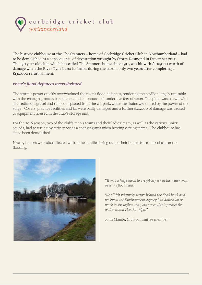
The historic clubhouse at the The Stanners – home of Corbridge Cricket Club in Northumberland – had to be demolished as a consequence of devastation wrought by Storm Desmond in December 2015. The 130 year-old club, which has called The Stanners home since 1911, was hit with £100,000 worth of damage when the River Tyne burst its banks during the storm, only two years after completing a £130,000 refurbishment.
river’s flood defences overwhelmed
The storm’s power quickly overwhelmed the river’s flood defences, rendering the pavilion largely unusable with the changing rooms, bar, kitchen and clubhouse left under five feet of water. The pitch was strewn with silt, sediment, gravel and rubble displaced from the car park, while the drains were lifted by the power of the surge. Covers, practice facilities and kit were badly damaged and a further £20,000 of damage was caused to equipment housed in the club’s storage unit.
For the 2016 season, two of the club’s men’s teams and their ladies’ team, as well as the various junior squads, had to use a tiny attic space as a changing area when hosting visiting teams. The clubhouse has since been demolished.
Nearby houses were also affected with some families being out of their homes for 10 months after the flooding.
“It was a huge shock to everybody when the water went over the flood bank.
We all felt relatively secure behind the flood bank and we know the Environment Agency had done a lot of work to strengthen that, but we couldn’t predict the water would rise that high.”
John Maude, Club committee member
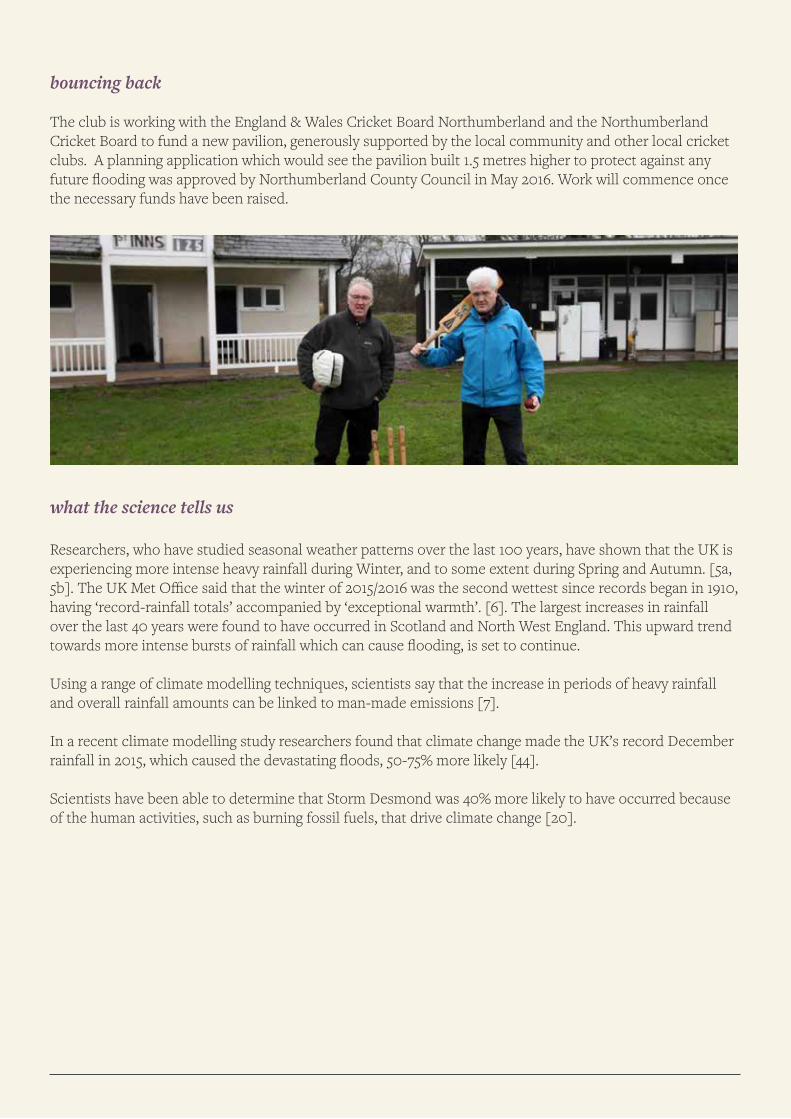
bouncing back
The club is working with the England & Wales Cricket Board Northumberland and the Northumberland Cricket Board to fund a new pavilion, generously supported by the local community and other local cricket clubs. A planning application which would see the pavilion built 1.5 metres higher to protect against any future flooding was approved by Northumberland County Council in May 2016. Work will commence once the necessary funds have been raised.
what the science tells us
Researchers, who have studied seasonal weather patterns over the last 100 years, have shown that the UK is experiencing more intense heavy rainfall during Winter, and to some extent during Spring and Autumn. [5a, 5b]. The UK Met Office said that the winter of 2015/2016 was the second wettest since records began in 1910, having ‘record-rainfall totals’ accompanied by ‘exceptional warmth’. [6]. The largest increases in rainfall over the last 40 years were found to have occurred in Scotland and North West England. This upward trend towards more intense bursts of rainfall which can cause flooding, is set to continue.
Using a range of climate modelling techniques, scientists say that the increase in periods of heavy rainfall and overall rainfall amounts can be linked to man-made emissions [7].
In a recent climate modelling study researchers found that climate change made the UK’s record December rainfall in 2015, which caused the devastating floods, 50-75% more likely [44].
Scientists have been able to determine that Storm Desmond was 40% more likely to have occurred because of the human activities, such as burning fossil fuels, that drive climate change [20].
p l a s c a d n a n t hidden gardens, anglesey
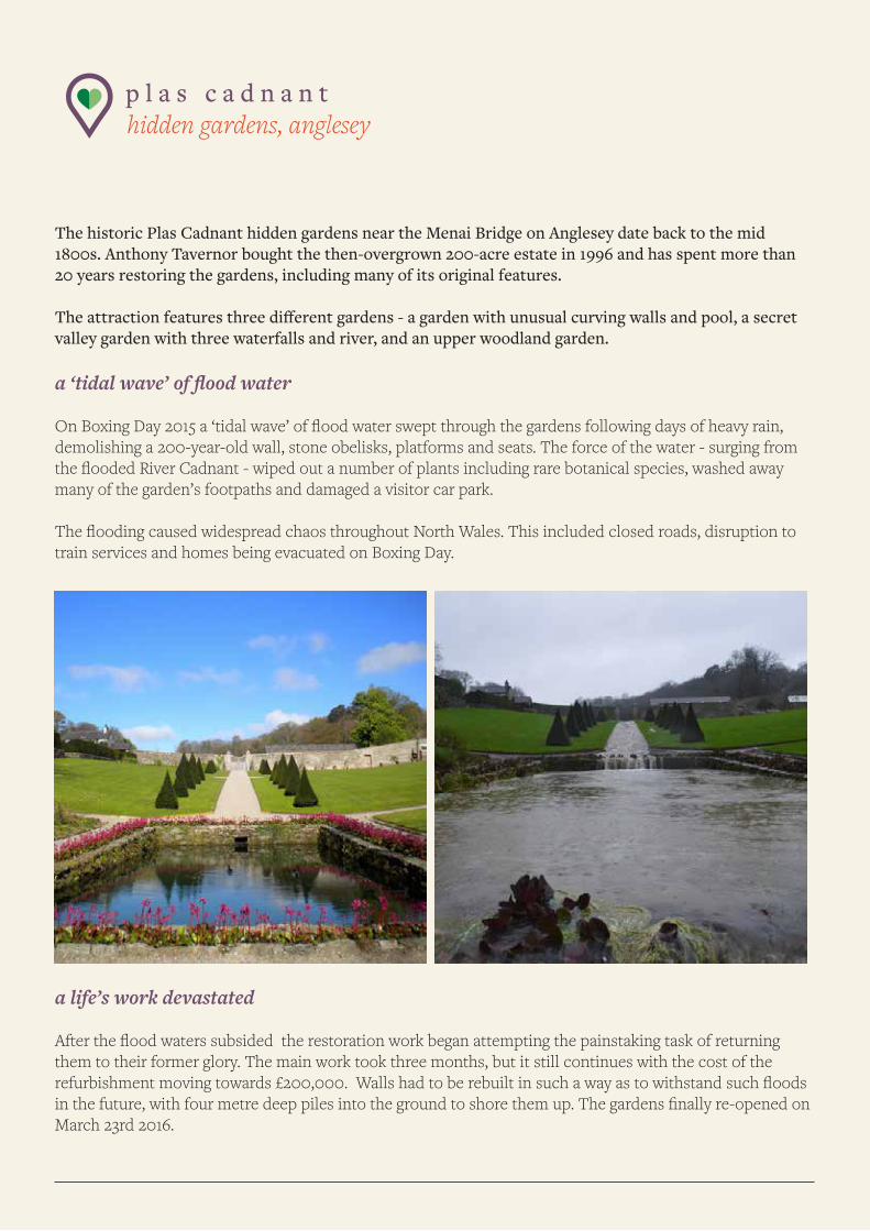
The historic Plas Cadnant hidden gardens near the Menai Bridge on Anglesey date back to the mid 1800s. Anthony Tavernor bought the then-overgrown 200-acre estate in 1996 and has spent more than 20 years restoring the gardens, including many of its original features.
The attraction features three different gardens - a garden with unusual curving walls and pool, a secret valley garden with three waterfalls and river, and an upper woodland garden.
a ‘tidal wave’ of flood water
On Boxing Day 2015 a ‘tidal wave’ of flood water swept through the gardens following days of heavy rain, demolishing a 200-year-old wall, stone obelisks, platforms and seats. The force of the water - surging from the flooded River Cadnant - wiped out a number of plants including rare botanical species, washed away many of the garden’s footpaths and damaged a visitor car park.
The flooding caused widespread chaos throughout North Wales. This included closed roads, disruption to train services and homes being evacuated on Boxing Day.
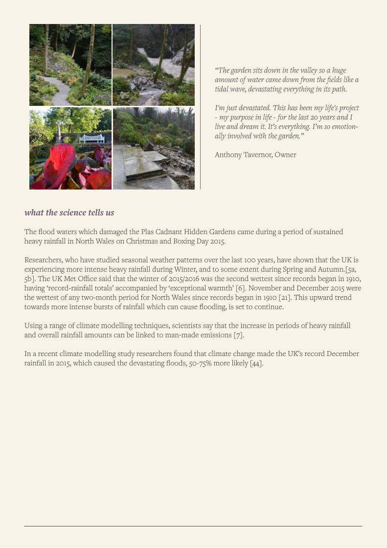
a life’s work devastated
After the flood waters subsided the restoration work began attempting the painstaking task of returning them to their former glory. The main work took three months, but it still continues with the cost of the refurbishment moving towards £200,000. Walls had to be rebuilt in such a way as to withstand such floods in the future, with four metre deep piles into the ground to shore them up. The gardens finally re-opened on March 23rd 2016.
what the science tells us
The flood waters which damaged the Plas Cadnant Hidden Gardens came during a period of sustained heavy rainfall in North Wales on Christmas and Boxing Day 2015.
Researchers, who have studied seasonal weather patterns over the last 100 years, have shown that the UK is experiencing more intense heavy rainfall during Winter, and to some extent during Spring and Autumn.[5a, 5b]. The UK Met Office said that the winter of 2015/2016 was the second wettest since records began in 1910, having ‘record-rainfall totals’ accompanied by ‘exceptional warmth’ [6]. November and December 2015 were the wettest of any two-month period for North Wales since records began in 1910 [21]. This upward trend towards more intense bursts of rainfall which can cause flooding, is set to continue.
Using a range of climate modelling techniques, scientists say that the increase in periods of heavy rainfall and overall rainfall amounts can be linked to man-made emissions [7].
In a recent climate modelling study researchers found that climate change made the UK’s record December rainfall in 2015, which caused the devastating floods, 50-75% more likely [44].
“The garden sits down in the valley so a huge amount of water came down from the fields like a tidal wave, devastating everything in its path.
I'm just devastated. This has been my life's project - my purpose in life - for the last 20 years and I live and dream it. It’s everything. I’m so emotion-ally involved with the garden.”
Anthony Tavernor, Owner
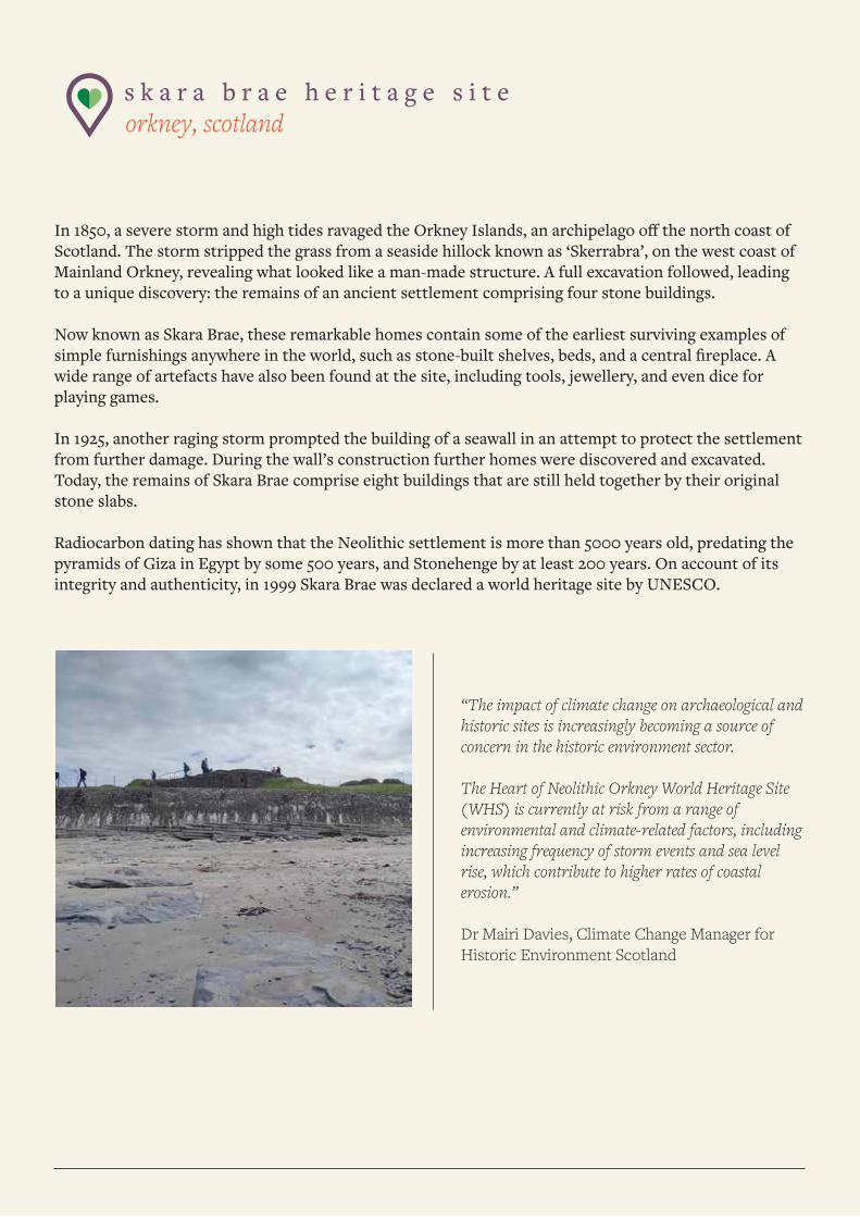
s k a r a b r a e h e r i t a g e s i t e orkney, scotland
In 1850, a severe storm and high tides ravaged the Orkney Islands, an archipelago off the north coast of Scotland. The storm stripped the grass from a seaside hillock known as ‘Skerrabra’, on the west coast of Mainland Orkney, revealing what looked like a man-made structure. A full excavation followed, leading to a unique discovery: the remains of an ancient settlement comprising four stone buildings.
Now known as Skara Brae, these remarkable homes contain some of the earliest surviving examples of simple furnishings anywhere in the world, such as stone-built shelves, beds, and a central fireplace. A wide range of artefacts have also been found at the site, including tools, jewellery, and even dice for playing games.
In 1925, another raging storm prompted the building of a seawall in an attempt to protect the settlement from further damage. During the wall’s construction further homes were discovered and excavated. Today, the remains of Skara Brae comprise eight buildings that are still held together by their original stone slabs.
Radiocarbon dating has shown that the Neolithic settlement is more than 5000 years old, predating the pyramids of Giza in Egypt by some 500 years, and Stonehenge by at least 200 years. On account of its integrity and authenticity, in 1999 Skara Brae was declared a world heritage site by UNESCO.
“The impact of climate change on archaeological and historic sites is increasingly becoming a source of concern in the historic environment sector.
The Heart of Neolithic Orkney World Heritage Site (WHS) is currently at risk from a range of environmental and climate-related factors, including increasing frequency of storm events and sea level rise, which contribute to higher rates of coastal erosion.”
Dr Mairi Davies, Climate Change Manager for Historic Environment Scotland

future threats, made by humans
Unfortunately, the type of extreme weather events which revealed this unique settlement in the first place, now put this ancient village’s long-term sustainability in doubt. Given its geographic location and specific position – the settlement is just a couple of metres from a low-lying beach and the ocean – climate change and its various consequences are a gathering threat.
The Heart of Neolithic Orkney World Heritage Site Management Plan says that Skara Brae is at “significant risk from a variety of climate-related factors”. The Plan, published in 2016, says that these include: “Increas-es in storminess and sea level rise and consequent increases in coast erosion; torrential rain and flooding; changes to wetting and drying cycles; and changes to flora and fauna.” It describes coastal erosion as “a threat to the long-term survival” of the subterranean village.
A report jointly authored by the Union of Concerned Scientists, the United Nations Environment Programme and UNESCO named Skara Brae as one of a number of world heritage sites at risk from climate change [22].
Dr Mairi Davies, Climate Change Manager for Historic Environment Scotland, said: “The impact of climate change on archaeological and historic sites is increasingly becoming a source of concern in the historic environment sector. The Heart of Neolithic Orkney World Heritage Site (WHS) is currently at risk from a range of environmental and climate-related factors, including increasing frequency of storm events and sea level rise, which contribute to higher rates of coastal erosion. This is reflected in the Management Plan; at Skara Brae we have a sea wall in place and are actively monitoring the coastal erosion through laser scanning surveys to gain a better understanding of the processes at work.”
A recent report by Historic Environment Scotland showed that climate change has already caused Scotland to become warmer and wetter over the past century and this has led to acceleration in environmental damage to historic sites from castles and monuments to Skara Brae [23].
what the science tells us
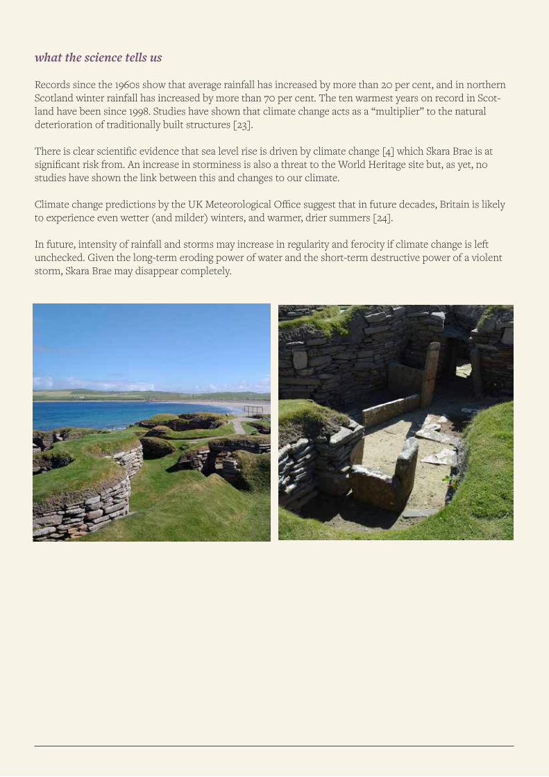
Records since the 1960s show that average rainfall has increased by more than 20 per cent, and in northern Scotland winter rainfall has increased by more than 70 per cent. The ten warmest years on record in Scot-land have been since 1998. Studies have shown that climate change acts as a “multiplier” to the natural deterioration of traditionally built structures [23].
There is clear scientific evidence that sea level rise is driven by climate change [4] which Skara Brae is at significant risk from. An increase in storminess is also a threat to the World Heritage site but, as yet, no studies have shown the link between this and changes to our climate.
Climate change predictions by the UK Meteorological Office suggest that in future decades, Britain is likely to experience even wetter (and milder) winters, and warmer, drier summers [24].
In future, intensity of rainfall and storms may increase in regularity and ferocity if climate change is left unchecked. Given the long-term eroding power of water and the short-term destructive power of a violent storm, Skara Brae may disappear completely.
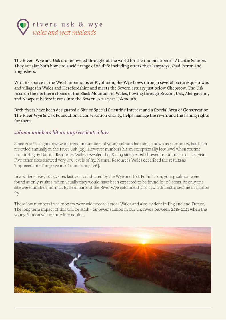
r i v e r s u s k & w y e wales and west midlands
The Rivers Wye and Usk are renowned throughout the world for their populations of Atlantic Salmon. They are also both home to a wide range of wildlife including otters river lampreys, shad, heron and kingfishers.
With its source in the Welsh mountains at Plynlimon, the Wye flows through several picturesque towns and villages in Wales and Herefordshire and meets the Severn estuary just below Chepstow. The Usk rises on the northern slopes of the Black Mountain in Wales, flowing through Brecon, Usk, Abergavenny and Newport before it runs into the Severn estuary at Uskmouth.
Both rivers have been designated a Site of Special Scientific Interest and a Special Area of Conservation. The River Wye & Usk Foundation, a conservation charity, helps manage the rivers and the fishing rights for them.
salmon numbers hit an unprecedented low
Since 2002 a slight downward trend in numbers of young salmon hatching, known as salmon fry, has been recorded annually in the River Usk [25]. However numbers hit an exceptionally low level when routine monitoring by Natural Resources Wales revealed that 8 of 13 sites tested showed no salmon at all last year. Five other sites showed very low levels of fry. Natural Resources Wales described the results as ‘unprecedented’ in 30 years of monitoring [26].
In a wider survey of 142 sites last year conducted by the Wye and Usk Foundation, young salmon were found at only 17 sites, when usually they would have been expected to be found in 108 areas. At only one site were numbers normal. Eastern parts of the River Wye catchment also saw a dramatic decline in salmon fry.
These low numbers in salmon fry were widespread across Wales and also evident in England and France. The long term impact of this will be stark - far fewer salmon in our UK rivers between 2018-2021 when the young Salmon will mature into adults.
record breaking warmer winter
December is peak spawning time for salmon in Wales. 2015 was recorded by the Met Office as the warmest and wettest since records began in 1910 [6].
The water temperature was extremely high for the time of the year registering at 12 - the norm being around 2-7-. In fact water temperature data from Natural Resources Wales shows that temperatures through late November and most of December were at a level where spawning would have been impaired [27].
The very low numbers of salmon fry recorded throughout Wales, England and France in 2015 led Natural Resources Wales to believe that a broad-scale common factor was at the heart of the problem. Having considered a number of possible causes they concluded that climatic changes were the most likely single contributing factor [28].
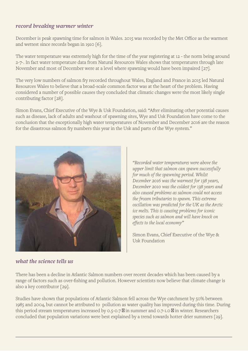
Simon Evans, Chief Executive of the Wye & Usk Foundation, said: “After eliminating other potential causes such as disease, lack of adults and washout of spawning sites, Wye and Usk Foundation have come to the conclusion that the exceptionally high water temperatures of November and December 2016 are the reason for the disastrous salmon fry numbers this year in the Usk and parts of the Wye system.”
what the science tells us
There has been a decline in Atlantic Salmon numbers over recent decades which has been caused by a range of factors such as over-fishing and pollution. However scientists now believe that climate change is also a key contributor [29].
Studies have shown that populations of Atlantic Salmon fell across the Wye catchment by 50% between 1985 and 2004, but cannot be attributed to pollution as water quality has improved during this time. During this period stream temperatures increased by 0.5-0.7 � in summer and 0.7-1.0 � in winter. Researchers concluded that population variations were best explained by a trend towards hotter drier summers [29].
“Recorded water temperatures were above the upper limit that salmon can spawn successfully for much of the spawning period. Whilst December 2016 was the warmest for 138 years, December 2010 was the coldest for 138 years and also caused problems as salmon could not access the frozen tributaries to spawn. This extreme oscillation was predicted for the UK as the Arctic ice melts. This is causing problems for iconic species such as salmon and will have knock on effects to the local economy”
Simon Evans, Chief Executive of the Wye & Usk Foundation
y h a k e s w i c k kendal, the lake district
Keswick is a popular tourist town nestled in the heart of the Lake District National Park. The youth hostel overlooks the river Greta and sits a short walk away from the banks of Derwent water, which is an incredible three miles in length. Hostel visitors tend to be walking enthusiasts hoping to climb Skiddaw, the tallest peak in the Lake District.
rising flood waters
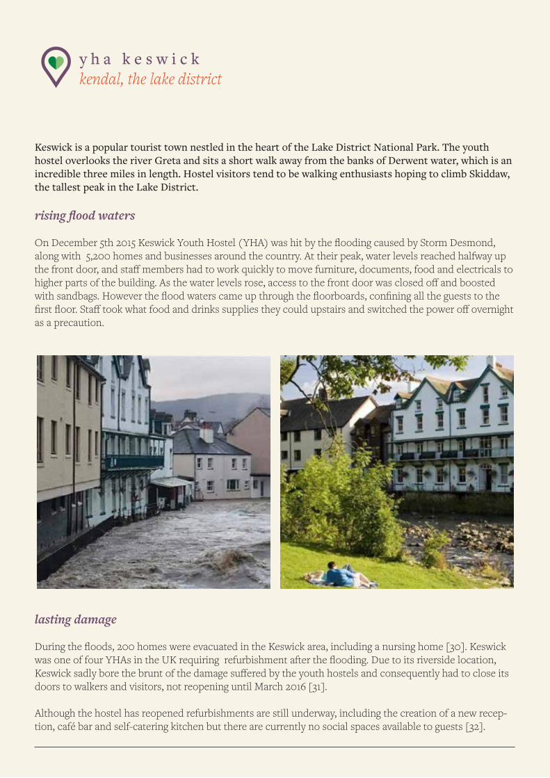
On December 5th 2015 Keswick Youth Hostel (YHA) was hit by the flooding caused by Storm Desmond, along with 5,200 homes and businesses around the country. At their peak, water levels reached halfway up the front door, and staff members had to work quickly to move furniture, documents, food and electricals to higher parts of the building. As the water levels rose, access to the front door was closed off and boosted with sandbags. However the flood waters came up through the floorboards, confining all the guests to the first floor. Staff took what food and drinks supplies they could upstairs and switched the power off overnight as a precaution.
lasting damage
During the floods, 200 homes were evacuated in the Keswick area, including a nursing home [30]. Keswick was one of four YHAs in the UK requiring refurbishment after the flooding. Due to its riverside location, Keswick sadly bore the brunt of the damage suffered by the youth hostels and consequently had to close its doors to walkers and visitors, not reopening until March 2016 [31].
Although the hostel has reopened refurbishments are still underway, including the creation of a new recep-tion, café bar and self-catering kitchen but there are currently no social spaces available to guests [32].
what the science tells us
Researchers, who have studied seasonal weather patterns over the last 100 years, have shown that the UK is experiencing more intense heavy rainfall during Winter, and to some extent during Spring and Autumn. [5a, 5b]. The UK Met Office said that the winter of 2015/2016 was the second wettest since records began in 1910, having ‘record-rainfall totals’ accompanied by ‘exceptional warmth’ [6]. The largest increases in rainfall over the last 40 years were found to have occurred in Scotland and North West England. This upward trend towards more intense bursts of rainfall which can cause flooding, is set to continue.
Using a range of climate modelling techniques, scientists say that the increase in periods of heavy rainfall and overall rainfall amounts can be linked to man-made emissions [7].
In a recent climate modelling study researchers found that climate change made the UK’s record December rainfall in 2015, which caused the devastating floods, 50-75% more likely [44].
Scientists have been able to determine that Storm Desmond was 40% more likely to have occurred because of the human activities, such as burning fossil fuels, that drive climate change [20].
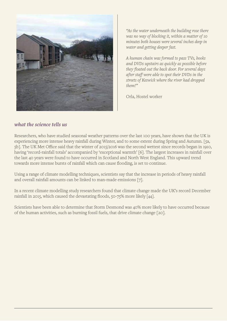
“As the water underneath the building rose there was no way of blocking it, within a matter of 10 minutes both houses were several inches deep in water and getting deeper fast.
A human chain was formed to pass TVs, books and DVDs upstairs as quickly as possible before they floated out the back door. For several days after staff were able to spot their DVDs in the streets of Keswick where the river had dropped them!”
Orla, Hostel worker
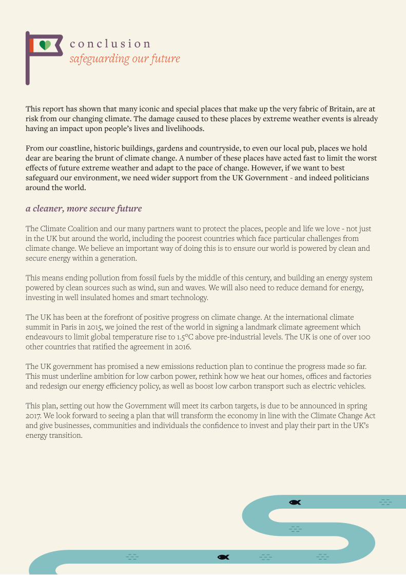
c o n c l u s i o n safeguarding our future
This report has shown that many iconic and special places that make up the very fabric of Britain, are at risk from our changing climate. The damage caused to these places by extreme weather events is already having an impact upon people’s lives and livelihoods.
From our coastline, historic buildings, gardens and countryside, to even our local pub, places we hold dear are bearing the brunt of climate change. A number of these places have acted fast to limit the worst effects of future extreme weather and adapt to the pace of change. However, if we want to best safeguard our environment, we need wider support from the UK Government - and indeed politicians around the world.
a cleaner, more secure future
The Climate Coalition and our many partners want to protect the places, people and life we love - not just in the UK but around the world, including the poorest countries which face particular challenges from climate change. We believe an important way of doing this is to ensure our world is powered by clean and secure energy within a generation.
This means ending pollution from fossil fuels by the middle of this century, and building an energy system powered by clean sources such as wind, sun and waves. We will also need to reduce demand for energy, investing in well insulated homes and smart technology.
The UK has been at the forefront of positive progress on climate change. At the international climate summit in Paris in 2015, we joined the rest of the world in signing a landmark climate agreement which endeavours to limit global temperature rise to 1.5°C above pre-industrial levels. The UK is one of over 100 other countries that ratified the agreement in 2016.
The UK government has promised a new emissions reduction plan to continue the progress made so far. This must underline ambition for low carbon power, rethink how we heat our homes, offices and factories and redesign our energy efficiency policy, as well as boost low carbon transport such as electric vehicles.
This plan, setting out how the Government will meet its carbon targets, is due to be announced in spring 2017. We look forward to seeing a plan that will transform the economy in line with the Climate Change Act and give businesses, communities and individuals the confidence to invest and play their part in the UK’s energy transition.
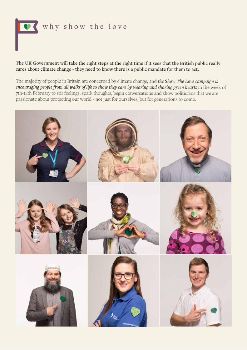
w h y s h o w t h e l o v e
The UK Government will take the right steps at the right time if it sees that the British public really cares about climate change - they need to know there is a public mandate for them to act.
The majority of people in Britain are concerned by climate change, and the Show The Love campaign is encouraging people from all walks of life to show they care by wearing and sharing green hearts in the week of 7th-14th February to stir feelings, spark thoughts, begin conversations and show politicians that we are passionate about protecting our world - not just for ourselves, but for generations to come.
1 2 r e a s o n s t o b e h o p e f u l
As these 12 case studies show, there is much at stake right now - and in the future - from warmer, wetter and more extreme weather that climate change is exacerbating. But there is also a huge amount of progress already being made as we move towards a cleaner and more secure energy system which could limit global warming and the impact it is having on our landscape and on our lives.
Around the world and here in Britain, more and more individuals, companies, institutions and governments are supporting and taking action to transition to cleaner, more sustainable and secure ways to power our world. We believe these are great reasons to be hopeful.
1. Lord’s Cricket Ground is the first national sporting venue in the UK to announce its transition to 100% clean, renewable energy.
2. Over a quarter (28%) of Grimsby’s ’s electricity consumption was met by renewable sources in March 2015 [33]
3. Between 23rd and 26th December, Scotland’s wind turbines generated enough electricity to power the entire country and the Scottish government has announced ambitious carbon cuts to reduce their emis-sions by 66% in just 15 years. [34]
4. Between August and September last year, the UK generated a quarter of all its electricity from renewable sources [35]
5. As of 1st January this year, all electric trains in the Netherlands were 100% powered by wind. Dutch trains use the same amount of electricity as all the households in Amsterdam, a significant carbon reduction [36]
6. In 2016, China installed three football pitches worth of solar every hour. In January 2017, they opened a four million panel strong solar panel park in Western Qinghai which supplies enough electricity to power 200,000 households. [37]
7. It’s estimated that enough solar power was installed in the USA in 2016 to power 1.8 million homes, and that in the same year, for the first time,more electricity-generating capacity from solar power plants is expected to have been built in the U.S. than from natural gas and wind [38].
8. 194 countries signed the historic Paris Climate Agreement in 2015 to help reduce greenhouse gas emis-sions and limit global warming. Since then 126 have legally bound themselves to it.
9. Renewable energy is providing a huge and rapidly increasing number of jobs. In the US, solar jobs were growing 12 times faster than the US economy [39].
10. In 2016, 47 of the world's most disadvantaged nations pledged to generate all their future energy needs from renewables [40].
11. More than two thirds (70%) of the British public are concerned about climate change, with more than four-fifths (84%) understanding that human activity is playing a role in driving it [41]. Furthermore, 73% of the British people back onshore wind power and 80% support solar farms [42].
12. The Show The Love campaign is brought to you by over 130 organisations and supported by a vast and varied mix of people, clubs, institutions and companies including the National Farmers’ Union, Aviva, Lord’s Cricket Ground, Manchester United, the RNLI, Ikea, Premier League, the YHA, Marks & Spencer, The Body Shop, Unilever...
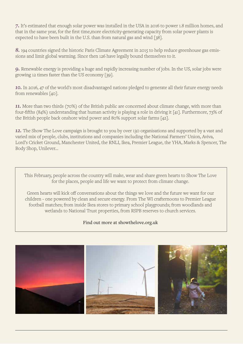
This February, people across the country will make, wear and share green hearts to Show The Love for the places, people and life we want to protect from climate change.
Green hearts will kick off conversations about the things we love and the future we want for our children - one powered by clean and secure energy. From The WI crafternoons to Premier League
football matches; from inside Ikea stores to primary school playgrounds; from woodlands and wetlands to National Trust properties, from RSPB reserves to church services.
Find out more at showthelove.org.uk
r e f e r e n c e s
1. Tubb, A. 2015. Coastal Retreat at Birling Gap, East Sussex: A Study of Historical Mapping. Groundsure[on-line]. Available at: https://www.groundsure.com/news/coastal-retreat-at-birling-gap/ . [Accessed: 27 January 2017]
2. National Trust. 2016. Dynamic coastlines and shifting shores at Birling Gap. National Trust[online]. Available at: https://www.nationaltrust.org.uk/birling-gap-and-the-seven-sisters/features/managing-change-at-birling-gap. [Accessed: 1 February 2017].
3. Millin, S. 2010. UKCP09 sea level change estimates. [onlin]. Available at: http://www.ukcip.org.uk/wordpress/wp-content/PDFs/UKCIP_sea-level.pdf. [Accessed: 1 February 2017]
4. Bindoff, N.L., P.A. Stott, K.M. AchutaRao, M.R. Allen, N. Gillett, D. Gutzler, K. Hansingo, G. Hegerl, Y. Hu, S. Jain, I.I.Mokhov, J. Overland, J. Perlwitz, R. Sebbari and X. Zhang, 2013: Detection and Attribution of Climate Change:from Global to Regional. In: Climate Change 2013:The Physical Science Basis. Contribution of Working Group to the Fifth Assessment Report of the Intergovernmental Panel on Climate Change [Stocker, T.F., D. Qin, G.-K.Plattner, M. Tignor, S.K. Allen, J. Boschung, A. Nauels, Y. Xia, V. Bex and P.M. Midgley (eds.)]. Cambridge University Press, Cambridge, United Kingdom and New York, NY, USA. 5. a) Osborn, T. J. et al. 2000. Observed trends in the daily intensity of United Kingdom precipitation. International Journal of Climatology 20. Page 347 - 364
b) Oborn, T.J. et al. 2002. Evidence for trends in heavy rainfall events over the United Kingdom. Philosophical Transactions of the Royal Society London series
6. Met Office. 2016. Winter 2015/ 2016. Met Office[online]. Available at: http://www.metoffice.gov.uk/climate/uk/summaries/2016/winter. [Accessed: 27 January 2017]
7. Boucher, O., D. Randall, P. Artaxo, C. Bretherton, G. Feingold, P. Forster, V.-M. Kerminen, Y. Kondo, H. Liao, U. Lohmann, P. Rasch, S.K. Satheesh, S. Sherwood, B. Stevens and X.Y. Zhang, 2013: Clouds and Aero-sols. In: Climate Change 2013: The Physical Science Basis. Contribution of Working Group I to the Fifth Assessment Report of the Intergovernmental Panel on Climate Change [Stocker, T.F., D. Qin, G.-K. Plattner, M. Tignor, S.K. Allen, J. Boschung, A. Nauels, Y. Xia, V. Bex and P.M. Midgley (eds.)]. Cambridge University Press, Cambridge, United Kingdom and New York, NY, USA.
8. Hubbard, J. 2013. The detrimental impact of floods on farming and rural areas. Ambiental[online]. Availa-ble at: http://www.ambiental.co.uk/detrimental-impact-of-floods-on-farming-and-rural-areas/. [Accessed 27 January 2017]
9. Gov.UK. 2015. Farming flood damage support announced. Gov.UK[online]. Available at: https://www.gov.uk/government/news/farming-flood-damage-support-announced. [Accessed: 1 February 2017].[Accessed: 1 February 2017].
10. Davies, I. 2016. Farmers count the cost of flood misery. Farmers Weekly[online]. Available at: http://www.fwi.co.uk/news/farmers-count-the-cost-of-flood-misery.htm. [Accessed: 27 January 2017].
11. National Farmers Union. 2016. Case Study: The importance of protecting agricultural land. NFU the voice of British farming[online]. Via NFU Online: http://bit.ly/2kemhJi[Accessed: 27 January 2017].
12. Gov. 2013. Sites of special scientific interest: managing your land. Gov.UK[online]. Available at: https://www.gov.uk/guidance/protected-areas-sites-of-special-scientific-interest. [Accessed 27 January 2017].
13.JNCC. 2015. Ramsar sites in the UK, its Overseas Territories and Crown Dependencies. JNCC[online]. Available at: http://jncc.defra.gov.uk/page-161. [Accessed 27 January 2017].
14. JNCC. 2013. Special Protection Areas (SPAs). JNCC[online]. Available at: http://jncc.defra.gov.uk/page-162. [Accessed 27 January 2017].
15. Committee on Climate Change. 2016. UK Climate Change Risk Assessment 2017 Synthesis report: priori-ties for the next five years. Chapter 3: Natural environment and natural Assets [online]. Available at: http://bit.ly/2j4V2PZ [Accessed: 1 February 2017].
16. Lehikoinen, A. & Jaatinen, K. 2012. Delayed autumn migration in northern European waterfowl. Journal of Ornithology 153(2). pp 563–570.
18. Usui, T., Butchart, S.H.M. and Phillimore, A.B. 2016. Temporal shifts and temperature sensitivity of avian spring migratory phenology: a phylogenetic meta-analysis. Journal of Animal Ecology. doi:10.1111/1365-2656.12612. Available at : http://onlinelibrary.wiley.com/doi/10.1111/1365-2656.12612/abstract. [Accessed: 1 February 2017].
19. Walters, S. 2017. Salford pub The Mark Addy will reopen - but we could have a long wait. Manchester Evening News[online]. Available at: http://bit.ly/2jULEPf [Accessed 30 January 2017].
20. World Weather Attribution. UK’s Storm Desmond, December 2015. Available at: https://wwa.climatecentral.org/analyses/climate-change-heavy-rains-uk-storm-desmond [Accessed: 06 February 2017].
21. Met Office. 2015. December 2015. Met Office[online]. Available at: http://www.metoffice.gov.uk/climate/uk/summaries/2015/december. [Accessed: 30 January 2017].
22. UNESCO. 2016. World Heritage and Tourism report shows sites at risk from climate change. UNESCO[online]. Available at: http://whc.unesco.org/en/news/1500. [Accessed 30 January 2017].
23. Historic Environment Scotland. 2017. £6.6 million for conservation of historic sites. Historic Environ-ment Scotland[online]. Available at: https://www.historicenvironment.scot/about-us/news/66-million-for-conservation-of-historic-sites. [Accessed: 30 January 2017].
24. Met Office. 2015. Climate: Observations, Projections and Impacts. Met Office[online]. Available at: http://www.metoffice.gov.uk/binaries/content/assets/mohippo/pdf/t/r/uk.pdf. [Accessed: 30 January 2017].
25. Natural Resources Wales Juvenile Salmonid Summary Paper 2016
26. Natural Resources Wales. 2016. Salmon stocks threatened by decline in fry numbers. Natural Resources Wales[online]. Available at: http://bit.ly/2jUIJWV. [Accessed: 30 January 2017].
27. Natural Resources Wales Abercynrig hatchery water temperature records.
28. Natural Resources Wales. Briefing Notes 2016
29. Clews, E. et al. 2010. Juvenile salmonid populations in a temperate river system track synoptic trends in climate. Global Change Biology. 16(12). Pages 3271–3283
30. Cumberland and Westmorland Herald. 2009. 200 homes evacuated as Keswick is cut off by floods. Cumberland and Westmorland Herald[online]. Avaialble at: http://www.cwherald.com/a/archive/200-homes-evacuated-as-keswick-is-cut-off-by-floods.336078.html. [Accessed: 30 January 2017].
31. YHA. 2015.Lake District Flooding - Update 22/12/15, 12pm. YHA[online]. Available at: http://www.yha.org.uk/media/news/lake-district-flooding-update-22/12/15-12pm. [Accessed 30 January 2017].
32. YHA Kewswick. 2016. YHA Keswick. YHA[online]. Available at: http://www.yha.org.uk/hostel/keswick. [Accessed: 30 January 2017].
33. Dewey, P. 2016. Cardiff named one of the UK's greenest cities but you'll never guess the top three. Wales Online[onlin]. Available at: http://www.walesonline.co.uk/news/wales-news/cardiff-named-one-uks-greenest-10855711. [Accessed: 31 January 2017].
34. Gov. Scot. 2017. Draft Climate Change Plan. The draft third report on policies and proposals 2017-2032. Gov. Scot[online]. Available at: http://www.gov.scot/Resource/0051/00513102.pdf. [Accessed: 1 February 2017]
35. Department for Business, Energy and Industrial Strategy. 2016. UK Energy Statistics, Q3 2016. Depart-ment for Business, Energy and Industrial Strategy[online]. Available at: http://bit.ly/2hKDls0. [Accessed: 31 January 2017].
36. Nederlandse Spoorwegen. 2016. Sustainable Energy. Nederlandse Spoorwegen[online]. Available at: http://www.ns.nl/en/about-ns/energy/sustainable-energy.html. [Accessed: 1 February 2017].
37. Phillips, T. 2017. China builds world's biggest solar farm in journey to become green superpower. Guardian. Available at: http://bit.ly/2jckFiN [Accessed: 1 February 2017].
38. Magill, B. 2016. Solar Farms Expected to Outpace Natural Gas in U.S. Climate Central[online]. Available at: http://www.climatecentral.org/news/solar-expected-to-outpace-natural-gas-21005. [Accessed: 31 January 2017].
39. Spector, J. Solar Jobs Are Outpacing the U.S. Economy By a Longshot. City Lab[onlin]. Available at: http://www.citylab.com/work/2016/01/solar-job-growth-american-economy-marco-rubio/424035/. [Accessed: 31 January 2017].
40. United Nations. 2016. COP22 - live blog. United Nations[online]. Available at: http://www.un.org/sustainabledevelopment/blog/2016/11/cop22-liveblog/. [Accessed: 1 February 2017].
41. Department for Energy, Business and Industrial Strategy. Energy and Climate Change Public Attitude Tracker. Department of Business, Energy and Industrial Strategy[online]. Available at: http://bit.ly/2kzEKku. [Accessed: 31 January 2017].
42. ComRes 2016. 10:10 Energy Survey. [online]. Available at: http://files.1010global.org/images/blown-away/1010WindPollComResData.pdf. [Accessed: 1 February 2017].
43. Fitzerald, D. M. 2008. Coastal Impacts Due to Sea-Level Rise. Annual Reviews 36. Pages 1 - 647.
44. Climate Predicition.net. 2016. 2015 December Extreme weather in the UK. Climate Predicition.net[on-line]. Available at: http://www.climateprediction.net/weatherathome/2015-december-extreme-weather-in-the-uk/

showthelove.org.uk#ShowTheLove