Weather - University of Delawareudel.edu/~ginah/geog152/152_10_weather_web.pdf · Weather: is the...
59
Weather Weather
Transcript of Weather - University of Delawareudel.edu/~ginah/geog152/152_10_weather_web.pdf · Weather: is the...

WeatherWeather

Weather:Weather:is the short term, day-to-day condition of the atmosphereis the short term, day-to-day condition of the atmosphere
Meteorology –Meteorology – the scientific study of the atmosphere the scientific study of the atmosphere They focus on physical characteristics and motion and how it They focus on physical characteristics and motion and how it
relates to chemical, biological, physical and geological processesrelates to chemical, biological, physical and geological processes Study complex linkages of atmospheric systemsStudy complex linkages of atmospheric systems Use this to forecast short-term future conditions of the atmosphereUse this to forecast short-term future conditions of the atmosphere

Mid-Latitude Weather SystemsMid-Latitude Weather Systems CycloneCyclone – Low-pressure system – Low-pressure system
Rising air, precipitationRising air, precipitation Relatively small, compact weather systemRelatively small, compact weather system
AnticycloneAnticyclone – High-pressure system – High-pressure system Descending air, clear skiesDescending air, clear skies Relatively large, expansive weather systemRelatively large, expansive weather system
““weather” caused by the interaction of cyclone and weather” caused by the interaction of cyclone and anticycloneanticyclone


Air Masses:Air Masses: each area of the earth’s surface imparts temperature and moisture each area of the earth’s surface imparts temperature and moisture
characteristics to the air abovecharacteristics to the air above This creates large, regional, homogenous masses of air with This creates large, regional, homogenous masses of air with
specific temperature, moisture and stability characteristicsspecific temperature, moisture and stability characteristics
Air mass –Air mass – distinctive body of air with specific temperature and moisture distinctive body of air with specific temperature and moisture characteristicscharacteristics→ → air masses interact to produce weather systemsair masses interact to produce weather systems

Air masses are labeled by their source region and also Air masses are labeled by their source region and also based on thermal and moisture characteristics:based on thermal and moisture characteristics:
1. Thermal1. Thermal• Tropical (T) Air Mass – warmTropical (T) Air Mass – warm• Polar (P) Air Mass – coldPolar (P) Air Mass – cold• Arctic (A) Air Mass – coldArctic (A) Air Mass – cold• Antarctic (AA) Air Mass - coldAntarctic (AA) Air Mass - cold
2. Moisture2. Moisture• Continental (c) Air Mass – dryContinental (c) Air Mass – dry• Maritime (m) Air Mass - moistMaritime (m) Air Mass - moist

Continental Polar (cP) –Continental Polar (cP) – cool dry air masses associated with cool dry air masses associated with anticyclonic conditionsanticyclonic conditions
Form only in the N. Hem b/c S. Hem doesn’t have polar land Form only in the N. Hem b/c S. Hem doesn’t have polar land massesmasses
Most developed in winterMost developed in winter Major players in high and middle latitude weather systems and Major players in high and middle latitude weather systems and
climateclimate Colder, more dense air pushes warmer air up over itColder, more dense air pushes warmer air up over it

Maritime Polar (mP) –Maritime Polar (mP) – cool, wet air masses associated with cyclonic cool, wet air masses associated with cyclonic conditionsconditions
Occur over northern oceansOccur over northern oceans Subpolar low pressure cells are located within this type of air massSubpolar low pressure cells are located within this type of air mass

Maritime Tropical (mT) –Maritime Tropical (mT) – warm, humid masses generally associated warm, humid masses generally associated with cyclonic activity, however this varies with air mass originwith cyclonic activity, however this varies with air mass origin There are two that affect N. America:There are two that affect N. America:
Gulf/Atlantic –Gulf/Atlantic – very unstable atmospheric conditions very unstable atmospheric conditions Active late spring to early fall (hurricane season)Active late spring to early fall (hurricane season) Responsible for the humidity experienced by the SE U.S.Responsible for the humidity experienced by the SE U.S. Tends to be warmer and wetter b/c of the pressure of the warm Gulf Tends to be warmer and wetter b/c of the pressure of the warm Gulf
Stream currentStream current
Pacific –Pacific – stable to conditionally unstable stable to conditionally unstable Cooler and less humid than Gulf/AtlanticCooler and less humid than Gulf/Atlantic Reason W U.S. is less humid and receives less rainfall than EReason W U.S. is less humid and receives less rainfall than E Cooler and drier due to cooler Pacific currents along the west coastCooler and drier due to cooler Pacific currents along the west coast

Continental Tropical (cT) –Continental Tropical (cT) – warm, dry masses associated with warm, dry masses associated with anticyclonic conditionsanticyclonic conditions Typical of tropical/subtropical continental locationsTypical of tropical/subtropical continental locations Hot, dry air (subtropical high pressure cellsHot, dry air (subtropical high pressure cells

Air Mass modification:Air Mass modification:
Air masses that move from their source region are modified Air masses that move from their source region are modified by the temperature and mositure characteristics of the by the temperature and mositure characteristics of the locations they passlocations they pass
EX:EX: cP air masses that travel south from their Canadian source will bring cP air masses that travel south from their Canadian source will bring frigid temperatures to southern latitudesfrigid temperatures to southern latitudes- - They begin with temps as low as -50 C but are generally warmer by the time They begin with temps as low as -50 C but are generally warmer by the time they reach their southernmost extent they reach their southernmost extent →→ warm as they move over warmer warm as they move over warmer surfacessurfaces
- they also can change their moisture characteristics - they also can change their moisture characteristics →→ lake effect snow lake effect snow

Atmospheric LiftingAtmospheric Lifting→ Precipitation→ Precipitation

In order for precipitation to occur, an air mass must:In order for precipitation to occur, an air mass must:
• Cool adiabaticallyCool adiabatically (by expansion) (by expansion)• Reach the Reach the dew point temperaturedew point temperature = achieving saturation = achieving saturation• After saturation, After saturation, water vapor will condensewater vapor will condense and form moisture droplets and form moisture droplets• Moisture droplets Moisture droplets form clouds and possibly precipitationform clouds and possibly precipitation
for this to happen and air mass must be lifted!for this to happen and air mass must be lifted!

There are four principle lifting mechanisms:There are four principle lifting mechanisms:
Convergent lifting Convergent lifting →→ air along the surface flows toward a low air along the surface flows toward a low pressure center and risespressure center and rises
Convectional lifting →Convectional lifting → local heating differences warm air above local heating differences warm air above causing it to risecausing it to rise
Orographic lifting →Orographic lifting → air is forced over a topographical barrier air is forced over a topographical barrier (mountain)(mountain)
Frontal lifting →Frontal lifting → air rises along the boundary between contrasting air rises along the boundary between contrasting air massesair masses

Convergent Lifting:Convergent Lifting: Air flows from different locations (converges) toward the center of a Air flows from different locations (converges) toward the center of a
low pressure systemlow pressure system Displacing air upwardDisplacing air upward Common in tropical regions where convergent lifting of warm, moist Common in tropical regions where convergent lifting of warm, moist
air leads to the formation of tropical stormsair leads to the formation of tropical storms Within the equatorial region the trade winds converge along the Within the equatorial region the trade winds converge along the
ITCZ, forcing air up creating large thunderstorms and high ITCZ, forcing air up creating large thunderstorms and high precipitaitonprecipitaiton

Convectional Lifting:Convectional Lifting: When cooler air masses move over warmer surfaces the warmer When cooler air masses move over warmer surfaces the warmer
surface heats the air mass from the bottom up (can be large or surface heats the air mass from the bottom up (can be large or local scale)local scale)
Warmer air from the bottom of the air mass rises causing Warmer air from the bottom of the air mass rises causing convection within the air massconvection within the air mass
Convection will continue within the air mass as long as conditions Convection will continue within the air mass as long as conditions are unstableare unstable
This lifting will create clouds and convectional precipitation (Atlanta)This lifting will create clouds and convectional precipitation (Atlanta)

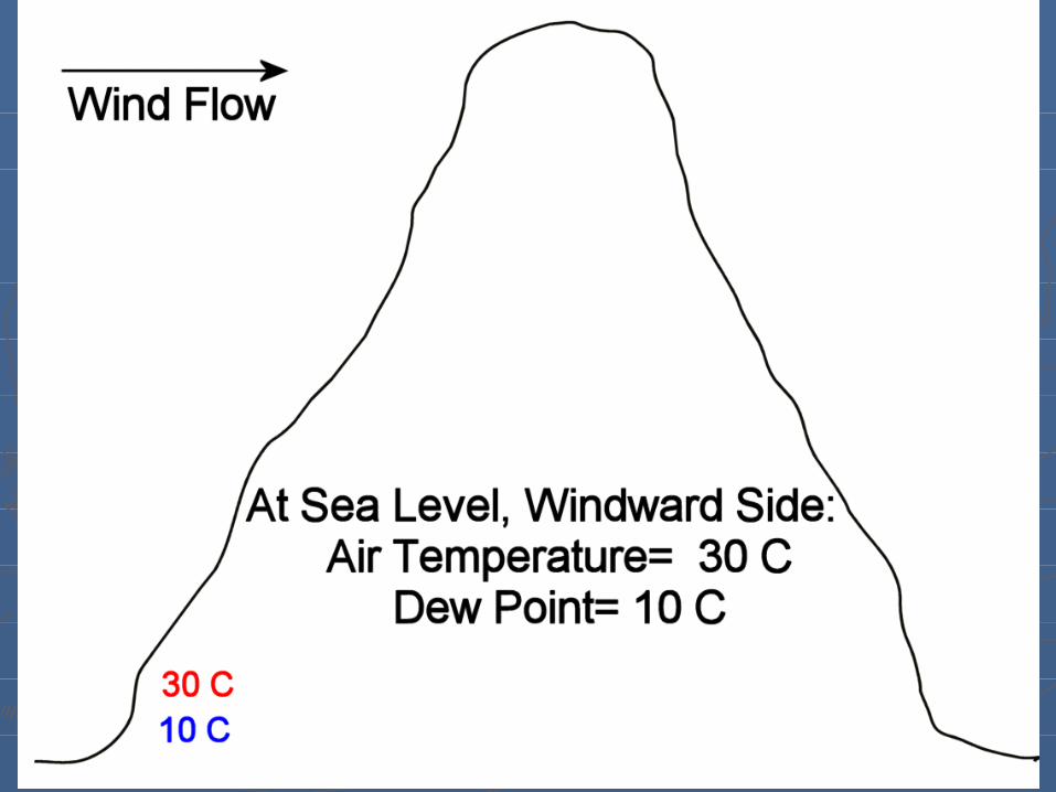
Orographic Lifting:Orographic Lifting: An air mass is physically forced upward as it pushes past a An air mass is physically forced upward as it pushes past a
mountainmountain As the air rises over the mountain it is cooled adiabaticallyAs the air rises over the mountain it is cooled adiabatically When it reaches the lifting condensation level, clouds formWhen it reaches the lifting condensation level, clouds form As it continues up the mountain convectional precipitation will As it continues up the mountain convectional precipitation will
developdevelop Precipitation will continue until the moisture content goes below Precipitation will continue until the moisture content goes below
saturation or the mass moves over the barriersaturation or the mass moves over the barrier
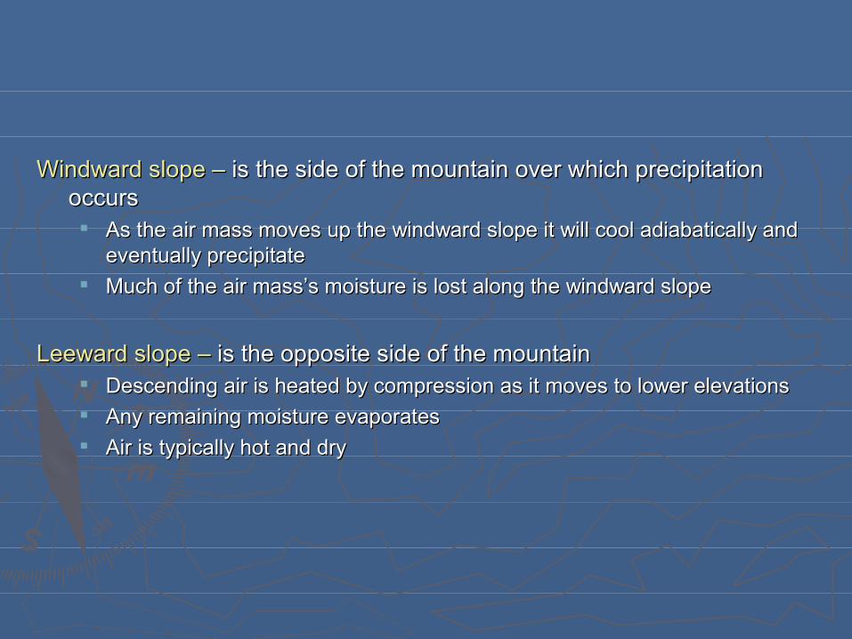
Windward slope –Windward slope – is the side of the mountain over which precipitation is the side of the mountain over which precipitation occursoccurs As the air mass moves up the windward slope it will cool adiabatically and As the air mass moves up the windward slope it will cool adiabatically and
eventually precipitateeventually precipitate Much of the air mass’s moisture is lost along the windward slopeMuch of the air mass’s moisture is lost along the windward slope
Leeward slope –Leeward slope – is the opposite side of the mountain is the opposite side of the mountain Descending air is heated by compression as it moves to lower elevationsDescending air is heated by compression as it moves to lower elevations Any remaining moisture evaporatesAny remaining moisture evaporates Air is typically hot and dryAir is typically hot and dry

WindwardLeeward


Chinook windsChinook winds → warm downslope airflow characteristic of → warm downslope airflow characteristic of leeward sideleeward side
Rainshadow Rainshadow → term applied to leeward side that receive very → term applied to leeward side that receive very little precip due to orographic liftinglittle precip due to orographic lifting

Frontal Lifting – Frontal Lifting –
Front:Front: the leading edge of an advancing air mass the leading edge of an advancing air mass The leading edge of a cold air mass is a The leading edge of a cold air mass is a cold frontcold front The leading edge of a warm air mass is a The leading edge of a warm air mass is a warm frontwarm front

Cold Front:Cold Front:• Indicates the advance of a cold air mass; Indicates the advance of a cold air mass;
• cold air is dense and a cold air mass will move as a dense mass of cold cold air is dense and a cold air mass will move as a dense mass of cold air, hugging the groundair, hugging the ground
• As a cold front moves into a region occupied by a warmer air mass, As a cold front moves into a region occupied by a warmer air mass, the warm air mass will rise sharply up and over the cold air massthe warm air mass will rise sharply up and over the cold air mass
• The warm air mass will cool adiabatically as it rises over a cold air The warm air mass will cool adiabatically as it rises over a cold air massmass
• This creates instability and cloud/precipitation (cumulonimbus)This creates instability and cloud/precipitation (cumulonimbus)

Cold Fronts:Cold Fronts: ctd ctd• Cold fronts are recognised by:Cold fronts are recognised by:
• Marked wind shift (usually northerly winds in the N. HemMarked wind shift (usually northerly winds in the N. Hem• Temperature dropTemperature drop• Lower barometric pressure due to rising air along the frontLower barometric pressure due to rising air along the front• Thick cloud formation and possibly heavy precipitationThick cloud formation and possibly heavy precipitation
• Once the front passes, have high pressure and lower temperaturesOnce the front passes, have high pressure and lower temperatures
In the U.S. and Canada, the clash of cold cP and mP air masses from the In the U.S. and Canada, the clash of cold cP and mP air masses from the north and warmer mT air masses from the south dominate our weather north and warmer mT air masses from the south dominate our weather patternspatterns

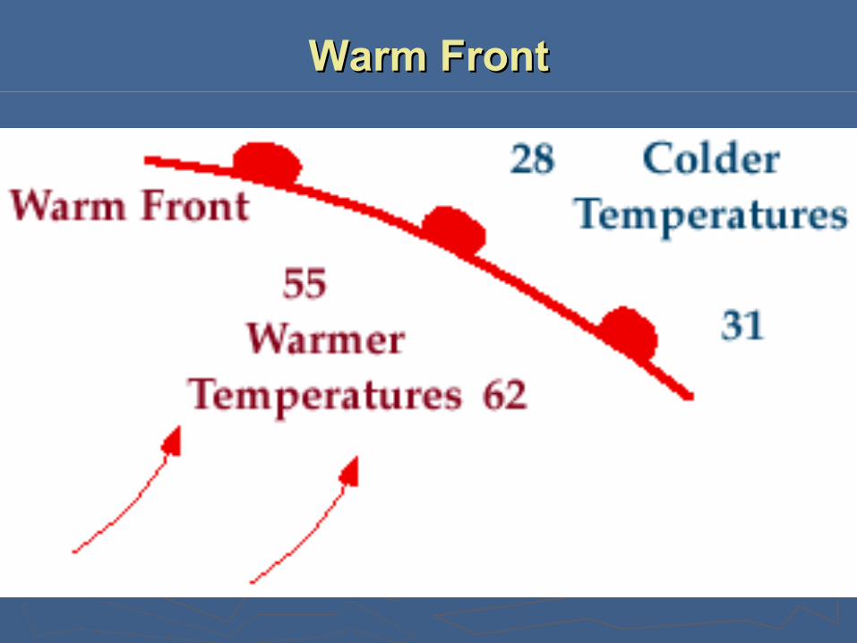
Warm Front:Warm Front:• Indicates the advance of a warm air massIndicates the advance of a warm air mass• The warm air mass is unable to displace the more dense cold air The warm air mass is unable to displace the more dense cold air
massmass• Warm air moves gently over the cold air massWarm air moves gently over the cold air mass
• The warm air will cool adiabatically as it rises over the cooler air massThe warm air will cool adiabatically as it rises over the cooler air mass• Water vapor will condense and clouds and possibly precipitation will Water vapor will condense and clouds and possibly precipitation will
develop (nimbostratus)develop (nimbostratus)• Precipitation is usually the light gentle drizzle rainPrecipitation is usually the light gentle drizzle rain

How air masses interact in the mid-latitudesHow air masses interact in the mid-latitudes

Midlatitude cyclone -Midlatitude cyclone - a mid latitude cyclone develops along the polar a mid latitude cyclone develops along the polar front when warm and cold air masses collide resulting in rising warm front when warm and cold air masses collide resulting in rising warm air and low pressure developmentair and low pressure development

Development of a midlatitude cyclone includes four stages that take 3-10 Development of a midlatitude cyclone includes four stages that take 3-10 days to complete:days to complete:
} CyclongensisCyclongensis - development of a low pressure center along the polar - development of a low pressure center along the polar frontfront
} Open stageOpen stage - northward advancement of warm air in front of the front - northward advancement of warm air in front of the front with cold air advancing south, curculating around a low pressure with cold air advancing south, curculating around a low pressure centercenter
} Occluded stageOccluded stage - cold front overrides the warm front - cold front overrides the warm front} Dissolving stageDissolving stage - warmer air is pushed aloft and rising stops - warmer air is pushed aloft and rising stops

Cyclogensis -Cyclogensis - low pressure systems develop and strengthen low pressure systems develop and strengthen
The polar front presents a discontinuity in temperature, moisture The polar front presents a discontinuity in temperature, moisture and wind direction leading to unstable atmospheric conditionsand wind direction leading to unstable atmospheric conditions
Air convergence occurs along the cold front but it must be Air convergence occurs along the cold front but it must be accompanied by diverging air aloftaccompanied by diverging air aloft Diverging air aloft allows the surface low to strengthen as more surface Diverging air aloft allows the surface low to strengthen as more surface
air is forced to rise to fill the void at upper levelsair is forced to rise to fill the void at upper levels

Open stage -Open stage - surface convergence strengthens the developing lowsurface convergence strengthens the developing low
Warm air moves north east of the cold front while cold air continues Warm air moves north east of the cold front while cold air continues to push southto push south
Ccw flow around the low draws more cold air from the north and Ccw flow around the low draws more cold air from the north and west and more warm air from the southwest and more warm air from the south

Occluded stage -Occluded stage - the cold front overtakes the warm front wedging underneath itthe cold front overtakes the warm front wedging underneath it The cold air mass is more homogenous in cold temperature and high The cold air mass is more homogenous in cold temperature and high
pressure than the warmer air masspressure than the warmer air mass It moves as a unified mass of colder, more dense airIt moves as a unified mass of colder, more dense air It moves faster than the warm front (40 km/hr vs. 16-24 km/hr)It moves faster than the warm front (40 km/hr vs. 16-24 km/hr)
Eventually it plows into the warm front forcing the warm front to move over Eventually it plows into the warm front forcing the warm front to move over the cold frontthe cold front
Occluded frontOccluded front - when a cold front overtakes a warm front - when a cold front overtakes a warm frontStationary frontStationary front - stalemate between warm and cold air masses - stalemate between warm and cold air masses
Generally you’ll get moderate to heavy precipitation which will eventually taper Generally you’ll get moderate to heavy precipitation which will eventually taper off as the cold front continues to force the warm air aloftoff as the cold front continues to force the warm air aloft

Dissolving stage -Dissolving stage - the low pressure center dissolvesthe low pressure center dissolves
As the cold front continues to move under the warm front the warm As the cold front continues to move under the warm front the warm air behind the warm front continues to riseair behind the warm front continues to rise
As the cold front completely overtakes the warm front the warm air As the cold front completely overtakes the warm front the warm air is pushed to upper levels above the cold air massis pushed to upper levels above the cold air mass
With no more warm air to move over the cold front the source of With no more warm air to move over the cold front the source of energy and moisture that feed the cyclone is goneenergy and moisture that feed the cyclone is gone
As the warm air ceases to rise over the cold front the low will As the warm air ceases to rise over the cold front the low will dissolvedissolve

Cold FrontCold Front
Warm FrontWarm Front

Stationary FrontStationary Front


A sharp cold front boundary can be seen on A sharp cold front boundary can be seen on both satellite pictures and radar compositesboth satellite pictures and radar composites

CyclonesCyclones

Characteristics of a wave cycloneCharacteristics of a wave cyclone
Cyclones normally move eastward, propelled by prevailing Cyclones normally move eastward, propelled by prevailing westerlies aloftwesterlies aloft
Cold front pushes south and east, supported by a flow of Cold front pushes south and east, supported by a flow of cold, dry polar aircold, dry polar air
The wind direction and temperature change abruptly as the The wind direction and temperature change abruptly as the cold front passescold front passes


Cold Front Approaches a Warm FrontCold Front Approaches a Warm Front
Example of an OcclusionExample of an Occlusion

• Cold front meets the warm front ahead of itCold front meets the warm front ahead of it
• Warm air is lifted upward, away from the surfaceWarm air is lifted upward, away from the surface
• Occluded front becomes longer Occluded front becomes longer more of the cold front more of the cold front converges converges with the warm frontwith the warm front
Example of an OcclusionExample of an Occlusion

• Eventually, the cold front completely overtakes the Eventually, the cold front completely overtakes the warm front warm front
• Entire system is occludedEntire system is occluded
Example of an OcclusionExample of an Occlusion

Cold frontCold front cold air moves cold air moves toward the warm air mass aheadtoward the warm air mass ahead
Warm frontWarm front warm air mass warm air mass moving toward a cold air massmoving toward a cold air mass
Stationary frontStationary front two unlike air two unlike air masses remain side by side, but masses remain side by side, but neither air mass has recently neither air mass has recently undergone substantial movementundergone substantial movement
Occluded frontOccluded front cold front meets cold front meets warm front, warm air gets lifted warm front, warm air gets lifted upward, away from the surfaceupward, away from the surface

When Air Masses Collide…When Air Masses Collide…
Dry LineDry Line – a front between warm, moist air and – a front between warm, moist air and warm, dry airwarm, dry air
Lifting is extremely strongLifting is extremely strong Heavy thundershowers, hail, and possible tornadoes are Heavy thundershowers, hail, and possible tornadoes are
characteristic of a dry linecharacteristic of a dry line Seen almost exclusively in the southern states west of the Seen almost exclusively in the southern states west of the
MississippiMississippi cT air versus mT air massescT air versus mT air masses

Dryline Over TexasDryline Over Texas
Notice the differences in the Notice the differences in the dew pointsdew points on both sides of the dryline. on both sides of the dryline.
Daily weather forecasting:Daily weather forecasting:
Synoptic Analysis:Synoptic Analysis: evaluation of weather data evaluation of weather data Numerical weather prediction - data base of weather conditions Numerical weather prediction - data base of weather conditions
used to forecast future weather eventsused to forecast future weather events Weather forecasting is difficult b/c the atmosphere is a nonlinear Weather forecasting is difficult b/c the atmosphere is a nonlinear
(irrational) system and tends toward chaos(irrational) system and tends toward chaos
Weather forecasts require information on:Weather forecasts require information on: Barometric pressure and pressure changesBarometric pressure and pressure changes Surface air and dew point temperatureSurface air and dew point temperature Wind speed, direction, and characterWind speed, direction, and character Cloud/sky conditions and visibilityCloud/sky conditions and visibility Current weather and precipitation recordCurrent weather and precipitation record

Today’s weatherToday’s weather