WCRP – developing knowledge and tools for application · WCRP – developing knowledge and tools...
30
John Church Chair World Climate Research Programme (January 2007) WCRP – developing knowledge and tools for application
Transcript of WCRP – developing knowledge and tools for application · WCRP – developing knowledge and tools...

John Church Chair
World Climate Research Programme(January 2007)
WCRP – developing knowledge and tools for application

Established 1980
Sponsors: WMO (1980+), ICSU (1980+) and IOC (1993+)
World Climate Research Programme
Objectives♦ To determine the predictability of climate♦ To determine the effect of human activities on climate

New Strategic Framework• Celebrated 25 years• Launched new Strategic
Framework 2005-15• To facilitate analysis &
prediction of Earth system variability & change for use in an increasing range of practical applications of direct relevance, benefit & value to society

WCRP Overview• Strategic Plan implementation• Strengthen Partnerships• Increase focus on end-users & added value• Integration across program; from observations, to
understanding, to prediction, to end users• Strengthen relationship with stakeholders• Changed management & new communication
– New Director: Prof. Ann Henderson-Sellers, January 2006– New Chair: Dr John Church, March 2006– New web, quarterly ‘e-zine’, reports

WCRP Science Underpins IPCC WG I
• Observations, understanding, prediction and application of the (physical) climate system
• Coordinate much of the science reviewed by IPCC WG1
• Underpin assessment of “What is “dangerous?”• Underpin impact/adaptation studies and
Sustainable Development (CSD-14, UN), MDGs• Collaborate with other GEC Programs and
cosponsor START (capacity building)• Oceans are central – your scientists are active
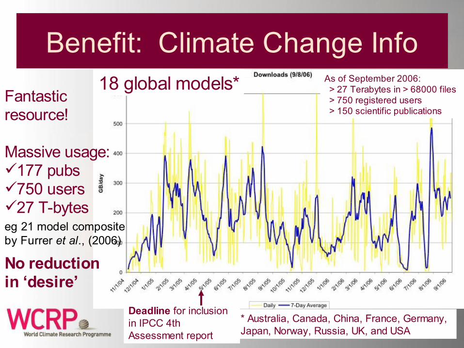
Benefit: Climate Change InfoAs of September 2006: > 27 Terabytes in > 68000 files > 750 registered users > 150 scientific publications
Deadline for inclusion in IPCC 4th Assessment report
Fantastic resource!
Massive usage:177 pubs750 users27 T-bytes
No reduction in ‘desire’
18 global models*
* Australia, Canada, China, France, Germany, Japan, Norway, Russia, UK, and USA
eg 21 model composite by Furrer et al., (2006)

El Nino: observation, modeling, assimilation, understanding, prediction
Global SST Departures (Deg C): 22 October-18 November 2006

Prediction of/changes in the Monsoons
Asian Monsoon Predictions
American Monsoons
Courtesy Kumar
Courtesy Gadgil & Webster
CLIVAR and GEWEX
• 60% world’s population live in monsoon regions• Over 80% of crops depend on monsoon rains
Monsoon variability affects food security. Knowledge needed for building stability and informing national policy and decisions.

Task Force on Seasonal Prediction
• Hypothesis: There is currently untapped seasonal predictability due to interactions (and memory) among all the elements of the climate system
• Seasonal Predictability Needs to be Assessed with Respect to a Changing Climate
• Weather Prediction Models (NWP Resolution) Should also Tested on Seasonal Time Scales– Collaboration with THORPEX
• Again, oceans are central

Bay of Bengal Major Surges1737 300,000 killed1864 100,0001876 100,0001897 175,0001970 300,000 (tide plus 6m surge)
And at least 23 surge events with over 10,000 killed since 1737
These considered lower limits as economic damage adds to eventual total
(Murty, Flather and Henry, 1986 Progress In OceanographyMurty and Flather, 1994 Journal of Coastal Research)
Woodworth et al., in prep.

Increasing concern about ice-sheet stability and a substantially larger rise in sea level
• WCRP Research results assessed by IPCC
Are we uncomfortably close to a tipping point and the melting of the Greenland Ice Sheet?
Ridley et al., 2005
• ½ world’s population live within 60 km of coasts• By 2040 > ¾ of us will live on or close to coasts• Environmental refugees a here and now issue
– Not “if” but “when and where and how will we respond”
• Sea level part of cryosphere and ocean projects – interdisciplinary workshop

Workshop on progress/uncertainties in our understanding of sea-level change
• WCRP Sea-level Workshop hosted by IOC (163 participants, 29 nations)
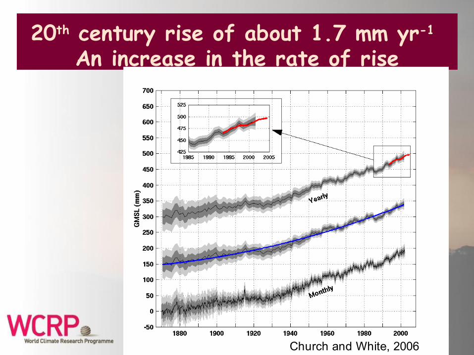
Church and White, 2006
20th century rise of about 1.7 mm yr-1 An increase in the rate of rise

Rate of rise for the last
20 years greater than any 20 year period over
the preceding 110 years

How well are the IPCC projections standing up to the test of time?
Rahmstorf et al.
•Temperature rise near upper limit of projections•Sea level rising at upper limit of the IPCC TAR projections (i.e. 88 cm rise by 2100)•CO2 projections match the observations.

Reducing uncertainty Observational Principles
• An open data policy with timely, unrestricted access for all (real time data)
• Data archaeology • Satellite observations need to be as
continuous as possible, with overlap between successive missions and coincident with the collection of appropriate in situ observations (GCOS observing principles).

Reducing uncertaintySustained, Systematic Observing Systems• Sea level
– Extend the Jason series of satellite altimeters through implementation of a Jason-3
– Complete the GLOSS network of tide gauges, absolute positioning, real-time data
• Ocean volume– Complete and sustain the Argo array of profiling
floats• Mass
– Sustain observations of the time-varying gravity field, GRACE and follow-on missions
• Terrestrial water storage, Ice sheet mass, Ocean mass

Reducing uncertainty Sustained, Systematic Observing
Systems• Ice sheet and glacier topography and thickness– Sustain radar altimeters (e.g., ENVISAT), ICESat
and, once launched, CryoSat-2 and Sentinel-3 altimetric satellites – complemented by aircraft and in situ observations
• Reference frame– Strengthen and sustain support for the
International Terrestrial Reference Frame• SLR, VLBI & DORIS• GNSS (GPS, together with GLONASS & Galileo once
launched)

Reducing uncertainty Observing Systems
• Ocean volume– Extend the Argo-type capability to under the sea ice.– Design and implement an effort to obtain observations for the
deep ocean • Ice sheet and glacier topography
– Based on experience gained with radar and laser satellite altimeters, develop a suitable follow-on satellite.
• Ice velocity – Interferometric Synthetic Aperture Radar (InSAR) mission to
observe flow rates in glaciers and ice sheets.• Surface topography
– Develop and implement the proposed WaTer mission with a wide-swath altimeter and interferometric SAR to observe the:
• Two-dimensional surface water levels on land.• Surface topography of glaciers and ice sheets.• Sea level associated with the oceanic mesoscale field.
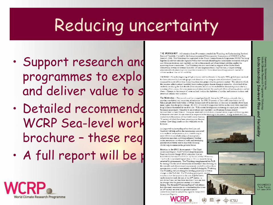
Reducing uncertainty
• Support research and observational programmes to exploit these data sets and deliver value to society
• Detailed recommendations from the WCRP Sea-level workshop are in the brochure – these require commitment!
• A full report will be published in 2007

The Future Sustained Ocean Observing Systemfor Climate -- Target 2008
Total Num ber of
ObservationsIn 1998.
1250 Surface Drifting Buoys(Global Coverage)
3000 Argo Profiling Floats(Global Coverage)
Sea Surface Temperature, Sea Surface Height, and Surface Vector Wind from Space
Tropical Moored Buoys
Ships of Opportunity
Argo Profiling Floats
Tide Gauge Stations
Ocean Reference
Stations
Surface Drifting Buoys
Dedicated Ships
Coastal Moored Buoys
Tide Gauge Stations, All GPS/DORIS located.
(Global Coverage)
Global System ? % Complete
note notenote

SouthEquatorial Current
Equatorial upwelling
East Australian
Current Tasman Front
Equatorial Undercurrent
SPICE - A Southwest Pacific Ocean Circulation and Climate Experiment
Water mass origins ?Subduction processesWater mass properties
EAC variability:Relation w/ climate/ENSO
Eddy generationAir-Sea fluxes
Jets and bifurcation:Dynamics ?
Contribution ?
Nor
thQ
ueen
slan
d C
urre
ntNorth Coral Sea:WBC Circulation
Flow through straits
Junction to the Equator:EUC feeding
Importance for ENSO
A. Ganachaud, S. Cravatte, L. Gourdeau (LEGOS/IRD), B. Kessler (NOAA/PMEL), K. Ridgway, W. Cai (CSIRO)B. Qiu (U. Hawaii), D. Roemmich, J. Sprintall, (Scripps/UCSD), M. Williams (NIWA)

IndOOS: Multi-platform Systemaround a basin-scale mooring array
Carbon/hydro cruise
High density XBT
Frequently repeated XBT
Enhanced XBT lines to monitor Indonesian Throughflow, inflow to western boundary, Java upwelling and 10°S thermocline ridge
Key new element—mooring array: ocean obs + meteorology
Argo floats 3°x 3° Drifters 5°x 5°
~20 real-time tide gauges
Regional mooring arrays

IOP Implementation Plan● The role of the Indian Ocean in the climate system—
implementation plan for sustained observations http://eprints.soton.ac.uk/19645/– Integrated approach to basin scale mooring array, Argo floats,
XBT lines, surface drifters, tide gauges– Observational strategies assessed by observing system
simulations– Science drivers: review and key questions
● Need commitments to complete observing system● Synergy paper being written by IOP-CoChair (G. Meyers)
and R.Bailey (BoM Australia)– Synergies with Tsunami Warning System– ship time? – mooring locations? joint packages / moorings? (carbon sensors
on TWS moorings)

CLIVAR Atlantic Ocean Observing Network
Compiled by R. Boscolo
CLIVAR website for details

CLIVAR Atlantic Implementation Panel
• Sustained Observations in support of decadal (ocean) signals not operational but could be.– MOC:
• Overflow measurements (Denmark Strait, FS Channel)• Boundary currents (transport, water masses)
- Labrador Sea outflow- 26N RAPID/MOCA & cable- NADW deep eddies, 20-30S (design research) ?
• Potential Energy time series- Labrador Sea, Bermuda- Irminger Sea, Porcupine Bank, Cape Verde (research)
– Tropical Atlantic Variability:• PIRATA + Extensions/replacements (research)• TACE (enhanced surface drifter & ARGO & PIRATA)

An Integrated and Coordinated System
CLIVAR, CliC, SCAR, …CASO iAOOS
IASC, AOSB, CliC, … CliC, Arctic-HYCOSArctic-HYDRA
Need IPY to lead to a plan for sustained polar observations

Issues• Need to anticipate progress during the
International Polar Year• International Repeat Hydrography and Carbon
Advisory Group (co-sponsored by IOCCP, CLIVAR-GSOP, SOLAS, IMBER, Joint Carbon Coordination Group) – POGO interest
• Need coherent approach across POGO and other existing planning procedures and committees (WCRP, GCOS/OOPC, GOOS, etc)

Key Messages• Climate research challenges are of increasing priority • Oceans central to climate – your scientists are engaged• Oceans central to the Climate SBA of GEO, Climate SBA
underpins many other GEO SBAs• Need comprehensive and coherent messages. Roles for
POGO, WCRP, GCOS/OOPC and GEO (What do you want WCRP to do for you? How can you help?)
• Exploit synergies with TWS and other disciplines• Development/use/publication of indices?• Need for ongoing instrument development• Need for follow up to OceanObs 99 (OOPC/WCRP and
POGO? GEO?)

WCRP – developing knowledge and tools for application
Thank you!


![CariM-i – develoPing a knowledge on india-eU Migration - 06.pdf · Developing a knowledge base for ... [title], CARIM-India RR ... Developing a knowledge base for policymaking on](https://static.fdocuments.in/doc/165x107/5a9ef3ef7f8b9a84178c1aa7/carim-i-developing-a-knowledge-on-india-eu-06pdfdeveloping-a-knowledge-base.jpg)