Watmough Bay Site Improvements Environmental Assessment ...
34
Watmough Bay Trailhead Improvements OR134-05-EA-012 1 Watmough Bay Site Improvements Environmental Assessment OR134-05-EA-012 Spokane District, Wenatchee Resource Area Introduction The Bureau of Land Management (BLM) is proposing site improvements on certain public lands it manages at Watmough Bay on Lopez Island. Watmough Bay is about 9 miles south of Lopez Village, along Watmough Head Road, in the southeasterly area of Lopez Island, within San Juan County. The property is legally described as a portion of Lot 2, Section 21, Township 34 North, Range 1 West, Willamette Meridian (see map, appendix C). The public lands at Watmough Bay are administered by the BLM’s Spokane District, Wenatchee Field Office as an Area of Critical Environmental Concern, (ACEC) to preserve its natural values. The Federal Land Policy and Management Act of 1976 defines ACECs as “areas within the public lands where special management attention is required (when such areas are developed or used or where no development is required) to protect and prevent irreparable damage to important historic, cultural, or scenic values, fish and wildlife resources or other natural systems or processes, or to protect life and safety from natural hazards.” Background Watmough Bay came under BLM administration after a series of Land and Water Conservation Fund acquistions were completed between 1992 and 1999. The area addressed in this environmental assessment was acquired from Stuart and Ilse Ole in 1994. Just prior to BLM’s purchase, the Ole’s conveyed fee title to a portion of the beach, granted a non-exclusive easement for beach access and parking, and issued a conservation easement for the freshwater wetland to the San Juan County Land Bank . The BLM and the San Juan County Land Bank have been cooperatively managing the area since that time. In keeping with the direction to manage acquired lands on Lopez Island as prescribed in the Final Planning Analysis, Environmental Assessment and Proposal Decision Record for the Proposed Iceberg Point and Point Colville Areas of Critical Environmental Concern, June 1990. Management of the Watmough Bay area has been generally limited to monitoring use and maintaining the area as an ACEC. Watmough Bay ACEC, is one of a few areas on Lopez Island where visitors can access a public beach and walking trails. As a result, this site receives approximately 15,000 visitors a year, including boaters, seasonal visitors, and permanent residents. Restroom: The existing restroom is a plastic, portable outhouse unit designed to meet the standards and guidelines of the American with Disabilities Act (ADA). For three months, during the seasonal, high-use period, an additional single portable outhouse is placed onsite to accommodate the increased amount of human waste. Due to the small amount of waste storage capacity in these units, the restrooms must be serviced weekly and sometimes biweekly. These regular services are costly and often unable to compete with the amount of waste. This results in an unpleasant experience for visitors. The portable outhouse company uses a scented, liquid chemical solution in the storage tanks, and often this scented formula strongly permeates the area. In this natural setting, the portable outhouses tend to present a visual perception of a temporary solution to a permanent need. Also, the current portable outhouse is not located to
Transcript of Watmough Bay Site Improvements Environmental Assessment ...

Watmough Bay Trailhead Improvements OR134-05-EA-012
1
Watmough Bay Site Improvements Environmental Assessment OR134-05-EA-012 Spokane District, Wenatchee Resource Area
Introduction The Bureau of Land Management (BLM) is proposing site improvements on certain public lands it manages at Watmough Bay on Lopez Island. Watmough Bay is about 9 miles south of Lopez Village, along Watmough Head Road, in the southeasterly area of Lopez Island, within San Juan County. The property is legally described as a portion of Lot 2, Section 21, Township 34 North, Range 1 West, Willamette Meridian (see map, appendix C). The public lands at Watmough Bay are administered by the BLM’s Spokane District, Wenatchee Field Office as an Area of Critical Environmental Concern, (ACEC) to preserve its natural values. The Federal Land Policy and Management Act of 1976 defines ACECs as “areas within the public lands where special management attention is required (when such areas are developed or used or where no development is required) to protect and prevent irreparable damage to important historic, cultural, or scenic values, fish and wildlife resources or other natural systems or processes, or to protect life and safety from natural hazards.” Background Watmough Bay came under BLM administration after a series of Land and Water Conservation Fund acquistions were completed between 1992 and 1999. The area addressed in this environmental assessment was acquired from Stuart and Ilse Ole in 1994. Just prior to BLM’s purchase, the Ole’s conveyed fee title to a portion of the beach, granted a non-exclusive easement for beach access and parking, and issued a conservation easement for the freshwater wetland to the San Juan County Land Bank . The BLM and the San Juan County Land Bank have been cooperatively managing the area since that time. In keeping with the direction to manage acquired lands on Lopez Island as prescribed in the Final Planning Analysis, Environmental Assessment and Proposal Decision Record for the Proposed Iceberg Point and Point Colville Areas of Critical Environmental Concern, June 1990. Management of the Watmough Bay area has been generally limited to monitoring use and maintaining the area as an ACEC. Watmough Bay ACEC, is one of a few areas on Lopez Island where visitors can access a public beach and walking trails. As a result, this site receives approximately 15,000 visitors a year, including boaters, seasonal visitors, and permanent residents. Restroom: The existing restroom is a plastic, portable outhouse unit designed to meet the standards and guidelines of the American with Disabilities Act (ADA). For three months, during the seasonal, high-use period, an additional single portable outhouse is placed onsite to accommodate the increased amount of human waste. Due to the small amount of waste storage capacity in these units, the restrooms must be serviced weekly and sometimes biweekly. These regular services are costly and often unable to compete with the amount of waste. This results in an unpleasant experience for visitors. The portable outhouse company uses a scented, liquid chemical solution in the storage tanks, and often this scented formula strongly permeates the area. In this natural setting, the portable outhouses tend to present a visual perception of a temporary solution to a permanent need. Also, the current portable outhouse is not located to
Watmough Bay Trailhead Improvements OR134-05-EA-012
2
afford sufficient exposure to the sun, which would maximize heating to assist with ventilation and reduce mildew build-up. Bike Rack: Currently there is one, wooden, bike rack available which is located at the eastern end of the parking area. This bike rack is often full or crowded during the high-use season. Due to the lack of adequate rack space, cyclists frequently ride their bikes down the hiking-only trail to the beach area. Iron Gate: A large, locked iron gate blocks vehicle access to the trail leading to the beach. The gate does not allow barrier-free access to the existing accessible trail. This reduces the possibility of an individual who may be mobility impaired to experience the area. Also, visually the iron gate presents a restrictive managerial presence. Creosote Posts: The two creosote posts supporting the iron gate at the trailhead emit a noxious creosote odor when daytime temperatures are high. Also, these creosote posts have potential to leach toxins to the local environment. During times of heavier rainfall, these toxins could be transported overland. Signs: The signs now posted at the site lack resource protection messages and are not uniform. BLM has identified a need for sign information about the sensitive nature of the area and BLM management objectives. Culvert: The culvert at the western edge of the parking area has been exposed due to erosion and vehicle traffic. The culvert’s exposure has worn the sides of the compacted gravel above the culvert and produced an unsafe approach as vehicles enter the parking area and turn to the right. Parking area: The parking area has many potholes, ranging from small to medium-sized. During and after rainfall events, these potholes retain water. During rainfall events, most of the parking area drains towards the nearby wetlands. During high-use periods the parking area can become congested and vehicles in the crowded parking area do not have sufficient room to turn around and exit. Access road: Improper road drainage and lack of routine maintenance has resulted in erosion and channeling of water. Gravel and finer minus materials are missing from most of the access road’s surface. The short length and approach of road drainage dips generates an abrupt transition as vehicles enter and leave them. In addition, the drainage dips do not allow water to leave the road’s edge, which results in water channeling, potholes, and muddy areas. Ditch line: Much of the existing ditch line has been filled with soil that has sloughed from the upslope edges of the southern embankment. The ditch line does not drain effectively nor properly catch the runoff from overland transport of water during rainfall events.

Watmough Bay Trailhead Improvements OR134-05-EA-012
3
Purpose and Need The size, type, and formation of existing facilities do not meet the current physical needs of the visiting public and lack essential elements to accommodate the current physical demand. As a result, there are natural values, for which the area was designated as an ACEC, which are being degraded. Improvements to the site are needed to accommodate the current use, protect the natural values of the ACEC and perform infrastructural maintenance. Compliance with Other Planning Documents and Laws The proposed action complies with the management direction for Lopez Island as set forth in the Spokane BLM District Final Planning Analysis, Environmental Assessment and Proposed Decision Record for the Proposed Iceberg Point and Point Colville Areas of Critical Environmental Concern (June 1990). Although there is no land use plan for BLM lands in San Juan County, BLM planning regulations (43 CFR 1610.8(b)) state that decisions will be based on an environmental assessment, environmental impact statement (if needed) and other data and analysis necessary to make an informed decision. Land Status The BLM’s Master Title Plats indicate the surface and mineral estate of the subject project lands are owned by the United States. As mentioned above, however, they are subject to a non-exclusive access easement held by the San Juan County Land Bank. This easement is 25 feet wide except at the parking area, where it expands to 60 feet wide. The conservation easement for the marsh includes the wetland proper along with the area within a 10 foot zone adjacent to the high water line thereof. Description of Alternatives Two action alternatives were developed to address the issues identified in the Purpose and Need section above: Alternative 1 (Proposed Action) and Alternative 2 (Modified Action). These two alternatives and Alternative 3 (No Action) are described individually below. Alternative 1 - Proposed Action Proposed improvements include removing the rented toilet and installing a vault toilet; installing one additional bike rack, removing the iron gate and creosote posts, installing three bollards, installing an informational kiosk, installing boulders near the new restroom facility, placing one to three boulders to armor the existing culvert, adding gravel to the parking area and access road, creating drivable drainage ditches along the access road, redefining the existing ditch line, selected tree removal, and slightly enlarging the size of the parking area. To avoid conflict with recreational use of the site, all large-scale projects will be scheduled between September 17 and May 15, which is outside the visitor high-use season. Details about these improvements are depicted on the attached diagrams and described below:
• Toilet Removal: The rental contract for the portable toilet would be cancelled, and the toilet and wooden screen structure next to the toilet would be removed from the premises. The ground area around the toilet would be scarified to remove small plants and grasses, and the area will be leveled. Gravel (0.75 inch in size) would be spread over the area to

Watmough Bay Trailhead Improvements OR134-05-EA-012
4
blend with the parking area and prepare for bike rack installation. • Toilet Replacement: A single vault, toilet meeting ADA requirements would be installed
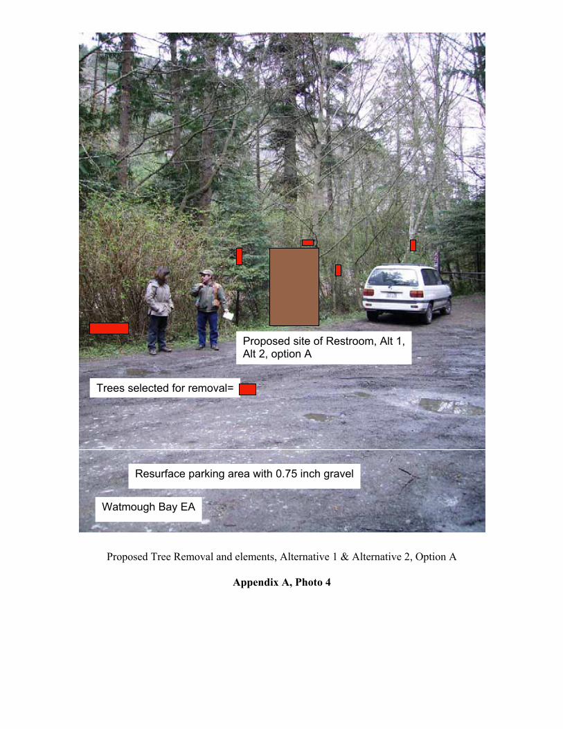
in the northeasterly section of the parking area. Fill soils and/or rock would be placed to level the area. Approximately 3 to 4 feet of fill would be added to the existing parking lot edge and spread throughout the proposed parking area enlargement. The toilet placement area (measuring about 5 feet deep, 8 feet wide, by 16 feet long) would be excavated. Excavation material would be replaced as needed to fill and level disturbed area. Excess excavated materials would be incorporated into the fill material and added to the overall proposed area. A medium-sized backhoe, dump truck, and crane unit would be used to prepare the area and place the toilet unit. The toilet unit would be delivered by a semi truck and heavy duty trailer. (see appendix A, photo 4, 6, appendix B, drawing 2)
• Additional Bike Rack: Position the bike racks to maximize their visibility, use and to provide maximum ADA clearances near and around footprint of bike racks. Both bike racks would be similar in style, shape, and color to make the most use of familiarity and uniformity with other bike racks on the island. (see appendix B, drawing 2)
• Iron Gate and Creosote Posts: The existing iron gate would be removed and transported offsite in cooperation with San Juan County Land Bank. The two creosote posts supporting the iron gate would also be removed, and the holes from the removal of the posts would be filled in with natural soils obtained from excavated toilet area and/or gravel (0.75 inch). (see appendix A, photo 8, appendix B, drawing 2)
• Three bollards: Three wooden bollards (round posts standing about 4 feet high) would be installed in the ground at the trailhead entrance. Bollards would meet ADA guidelines and be locked in place with keyed-alike locks to accommodate safety, maintenance, fire, and search and rescue. (see appendix A, photo 8, appendix B, drawing 2, 5)
• Kiosk: An informational kiosk would be built and installed at the trailhead entrance. The emphasis will be on information specific to BLM site management and resource protection. The kiosk will meet ADA guidelines, and be three feet tall, five feet wide, single planked gabled roof and erected on two treated posts, four inches by four inches. (see appendix B, drawing 2)
• Large Boulders: Install approximately seven to ten boulders to prevent vehicles from damaging newly installed restroom. Large boulders weighing about 1 ton would be placed around the restroom no more than 60 inches apart. Utilize large boulders approximately 1 ton and recess 1/3rd of their size into the ground. Placement of boulders will meet ADA guidelines. (see appendix B, drawing 2)
• Culvert: Both sides of the culvert would be reinforced with medium to large-sized rocks. (see appendix A, photo 5, appendix B, drawing 2)
• Parking Area and Access Road: Gravel (0.75 inch) would be added to the entire parking area and access road. Low areas in the parking area would be filled with gravel to create a southward sloping drainage to ditch line. Three drivable drainage ditches would be created along the access road; the ditches would out-slope to the existing ditch line and culverts. (see appendix A, photo 2, 4, 9, appendix B, drawing 2)
• Ditch Line: The ditch line would be increased easterly as the ditch line follows the parking area so as to catch more of the runoff from the upslope hillside. The existing ditch would be cleared to the culvert area. (see appendix A, photo 9, appendix B, drawing 2)
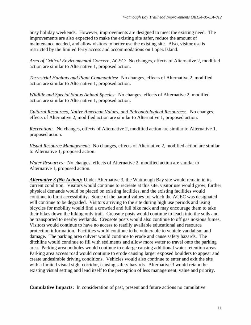
• Selected tree removal: Designated trees which have been identified for removal to allow
Watmough Bay Trailhead Improvements OR134-05-EA-012
5
greater sunlight exposure and reduce shading of the restroom would be felled and made available for firewood. (see appendix A, photo 1, 2, 4, appendix B, drawing 2)
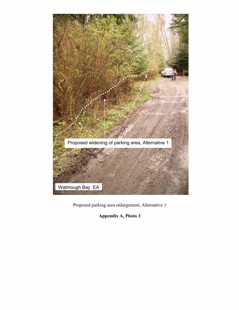
• Parking Area: The parking area would be enlarged, approximately 800 square feet, beginning with a fill and taper from the existing culvert easterly along the northern edge of parking area. The enlarged area would be about 8 feet wide by 20 feet long. Continue to fill and taper to a distance of sixteen feet wide for the remainder of the easterly track of the northern edge of existing parking area. Fill expanded parking area with soils and or crushed rock from one to three feet in depth and as wide as prescribed. Layer outer edges of fill area with several layers of pit run # 5 to provide stability and reduce erosion. (see appendix A, photo 1, 2, 3, appendix B, drawing 2)
Project Design Features An intensive BLM class III cultural resources inventory will be conducted in the area of potential effect prior to project implementation. If historically significant resources, traditional cultural properties or sacred areas are identified, the project will be redesigned to avoid them. If the sites cannot be avoided, consultation with Department of Archaeology and Historic Preservation (DAHP), consulting tribes and interested public will be conducted. If significant paleontological resources are located prior to or during project implementation, the project will be redesigned to avoid the resource. If the resource cannot be avoided, the locality will be evaluated and mitigation will be implemented. If any cultural or paleontological resources are encountered during project implementation, the disturbing activity will be halted and a BLM archaeologist will be notified. Archaeological materials will be evaluated in consultation with affected tribes and DAHP. The project area will be field inventoried for special status plants prior to ground-disturbing activities. If special status plants are found, effects will be assessed and the project may need to be modified to protect the plant population. If any wildlife species that are sensitive to noise or disturbances are found, project activities would be modified to minimize or avoid disturbance. Alternative 2-Modified Action Modified improvements include many of the same elements as Alternative 1 with the following changes:
• Install single vault, ADA toilet, Site Location Option A: Unit would be installed for maximized sun light heating, ventilation and to reduce mildew build up at the north easterly section of parking area. Approximately three to four feet of fill would be added to existing parking lot edge and spread throughout a four foot wide perimeter for the foot print of the toilet. The pre-installation foot print for the unit would be excavated to approximately five foot deep, eight feet wide, by sixteen feet long. Excavation material would be replaced as needed to fill and level disturbed area. (see appendix A, photo 4, appendix B, drawing 3,)
• Enlarge parking area: No enlargement of parking area.

Watmough Bay Trailhead Improvements OR134-05-EA-012
6
• Install single vault, ADA toilet, Site Location Option B: Unit would be installed in approximately the same location as the existing portable restroom. The pre-installation foot print for the unit would be excavated to approximately five foot deep, eight feet wide, by sixteen feet long. Excavation material would be replaced as needed to fill and level disturbed area. Excess material from excavation and deposit would be removed appropriately through local contractor. (see appendix A, photo 14, appendix B, drawing 4,)
• Kiosk: An informational kiosk would be built and installed at the north trailhead entrance (see appendix B, drawing 4).
• Selected tree removal: Designated trees which have been identified for removal to allow greater sunlight exposure and reduce shading of the restroom would be felled and made available for firewood. (see appendix A, photo 10, 11, 12, 13, appendix B, drawing 4)
• Enlarge parking area: No enlargement of parking area.
Alternative 3-No Action Under this alternative, the Watmough Bay ACEC site would remain in its current condition. No large scale improvements such as widening the parking area or adding a concrete, vault toilet would be implemented. Regular and routine maintenance would still occur. (see appendix A, photo 15) Affected Environment Area of Critical Environmental Concern, ACEC Watmough Bay has been designated and Area of Critical Environmental Concern (ACEC). Under this designation management of Watmough Bay ACEC emphasizes preservation of the natural values of this site. Opportunities for visitor use are provided to the extent they are compatible with the preservation of the natural values. If a choice must be made between preservation of the natural values and allowing visitor use, preservation of the natural values is the primary consideration. Terrestrial Habitats and Plant Communities: Habitats at Watmough include coniferous forest, wetland, cliff, gravel beach and aquatic marine. Forest habitat is a mix of mature Douglas-fir (Pseudotsuga menziesii), western hemlock (Tsuga heterophylla), grand fir (Abies grandis), Sitka spruce (Picea sitchensis), and western redcedar (Thuja plicata). Red alder (Alnus rubra), Scouler’s willow (Salix scoulerana), and Douglas maple (Acer glabrum) are also present. Cattails (Typha latifolia) are the dominant emergent vegetation in the wetlands north of the parking area. Nootka rose (Rosa nootkana), salmonberry (Rubus spectabilis), and snowberry (Symphoricarpos albus) bound the wetland and beach. The south face of Chadwick Hill is a series of cliffs interspersed with Pacific madrone (Arbutus menziesii). Beach habitat includes a series of large logs that have drifted in during winter storms and the gravel/sand beach.

Watmough Bay Trailhead Improvements OR134-05-EA-012
7
Near shore fish that occur in the bay include Pacific herring (Clupea harengus), Pacific sand lance (Ammodytes hexapterus), surf smelt (Hypomesus pretiosus), sculpin (Cottidae), greenling (Hexagrammidae), flounder (Pleuronectidae), and rockfish (Scorpaenidae). Wildlife: Birds commonly seen near Watmough Bay include Northwestern crow, turkey vulture, bald eagle, great blue heron, violet-green swallow, Bewick’s wren, chestnut-backed chickadee, white-crowned sparrow, and song sparrow. Black-tailed deer, raccoons, and Yuma and California myotis are some of the terrestrial mammals found in the vicinity of the project. Coastal and marine birds are abundant around the point and include pelagic cormorant, glaucous-winged gull, and pigeon guillemot. From April to May, neotropical migrant bird species may be found in the vicinity. Harbor seals and river otters are frequent visitors to the bay. Special Status Animal Species: Special status wildlife species in the area include marbled murrelet (Federal and State Threatened), bald eagle (State Threatened and Federal Species of Concern), and peregrine falcon (State Sensitive and Federal Species of Concern). Murrelets are common off shore, but do not nest on Lopez Island. Eagles are present year round and perch in many large trees with open canopies and large lateral limbs. There is one bald eagle territory approximately one mile north-east of the bay. Peregrine falcons nest on the cliff above Watmough Bay and are commonly seen and heard in spring and early summer. Falcons do not tolerate bald eagles during the nesting season and chase any that fly too close to the eyrie. No peregrine chicks have fledged from this territory in recent years. Cultural Resources, Native American Values, and Paleonotological Resources: The project area occupies the traditional homelands of the Central Coast Salish, which includes tribes associated with the Northern Strait language. Regional histories note these tribes shared similar subsistence patterns characterized by a reliance on fish, game, and edible plants and roots. Village locations would have provided access for resource gathering including fishing and hunting. Salmon, halibut and sturgeon were among the fish predominantly harvested. A variety of sea mammals, waterfowl, and various land mammals were hunted, while roots, berries, bulbs and shell fish were gathered throughout the Central Coast Salish territory. Many traditional fishing stations and hunting and gathering areas continue to be utilized by Native Americans in the region. Prior to acquisition of the federal parcel at Watmough Bay, a parking area and road had been constructed to provide access to the beach and an early twentieth century home located between the beach and wetlands at the Bay. The home, constructed in the early 20th century, was burned and removed from the property prior to acquisition by BLM. The parking area and road were modified and dozed and a metal gate was installed to control vehicle access to the beach by subsequent land owners. Archival records, previous inventories, and Washington Department of Archaeological and Historic Preservation (DAHP) and BLM site databases were reviewed and intensive cultural resource inventory was conducted to determine if cultural resources had been identified in the project area. Although properties eligible for the National Register of Historic Places were
Watmough Bay Trailhead Improvements OR134-05-EA-012
8
identified in the area, none were identified in the project’s area of potential effect (APE). Previous disturbance during parking area construction prior to BLM acquisition has altered much of the project area. Geological and archival records were reviewed, and no paleontological resources are known to occur in the project area. Recreation: The Watmough Bay ACEC site is the most heavily used BLM area on Lopez Island. Facilities at the site include one plastic portable outhouse (two during busiest summer months), one iron gate with two large diameter creosote pots which hold the gate, one wooden bike rack, a small gravel parking area and access road, an accessible trail, a hiking trail and assorted signage. Approximately 15,000 people visit the Watmough Bay ACEC site annually. The high use season is from May 15 to about September 15. The majority of visitors are local residents, but the site also receives visitors from off-island. Visitor use occurs throughout the year and consists of kayak launching, picnicking, water play, traditional rock climbing, hiking, boat mooring, wildlife viewing and other beach activities. Although the site is managed as day use only, some overnight unauthorized camping does occur. Visual Resource Management: The trailhead and access road are comprised of a wide variety of green vegetation, including Douglas-firs, cedars, alders, ocean spray and others. The trailhead parking lot and access road surface areas range from dark grays to lighter grays which fluctuate depending on the amount of rainfall, shade and moisture retention. Overall the trailhead, access road and existing facilities appear primitive. The encroaching trees, tight canopy, and lack of homes present a secluded setting. Environmental Impacts Alternative 1 (Proposed Action): Impacts from the proposed action are expected to be limited to the parking area and the access road. Approximately 800 square feet along the northern margin of the existing parking area would be filled with soil to create space for the new outhouse and parking area enlargement. A very small portion of the woodland habitat would be removed. The gravel fill would be stabilized by riprap to limit the extent of fill needed for the project. Implementing these improvements at Watmough Bay ACEC could make the area more attractive. Additional visitors to the site are expected based on growth projections of the San Juan Islands and visitor use monitoring. Increased use could result in additional crowding on busy holiday weekends. However, improvements are designed to meet the existing need. The improvements are also expected to make the existing site safer, reduce the amount of maintenance needed, and allow visitors to better use the existing site. Also, visitor use is restricted by the limited ferry access and accommodations on Lopez Island. Area of Critical Environmental Concern, ACEC

Watmough Bay Trailhead Improvements OR134-05-EA-012
9
The incorporation of the proposed improvements would assist in the preservation of the natural values of the area through removal of the creosote logs, more readily available educational information of the environmental concerns of the area, less bike effects to the trail and beach area, less sedimentation eroding into the wetlands, and less synthetic aromas from the designated toilet area. Terrestrial Habitats and Plant Communities: Designated trees would be removed from the woodland habitat. The use of gravel fill and riprap would likely preclude woodlands from reestablishing, and encourage herbaceous shrubs forbs and grass species, including weedy species in it's place. No effects are expected for near shore fish or communities. Removal of the creosote posts would eliminate further leaching into the drainage leading to the wetlands. Wildlife and Special Status Animal Species: Construction activities would disturb and displace wildlife present at the time of construction. From September to March these would include resident wildlife such as northwest crow, bald eagle, and chestnut-backed chickadee. In April and May, neotropical migrant species may be affected. Disturbance effects would be short-term during construction activities and surrounding woodland vegetation would provide alternative habitats for resident and migratory species. The possibility of increased levels of recreational use in the summer could also disturb and displace wildlife but this effect would be only slightly greater than existing conditions and mostly limited to holiday weekends. The project would have no effect on marbled murrelet and only short-term, insignificant effects on bald eagle and peregrine falcon during the short period of construction activities from noise. Marine fish and seabirds would not be affected by the project. Cultural Resources, Native American Values, and Paleonotological Resources: Because most of the area to be disturbed in this alternative was previously disturbed and covered by fill, implementation of this alternative is not expected to impact cultural resources eligible for the National Register of Historic Places. Increased visitor use may increase vandalism or disturbance of sensitive Historic Properties within the ACEC. Recreation: Based on projected growth for the area and increased visitor use recorded through routine monitoring, impacts to the area could be expected. The installation of the additional bike rack will provide an adequate facility for visitors’ bikes, and will discourage them from taking them on the trails which are closed to this use. Installation of the bollards will help to control traffic in the parking area. Removal of the creosote logs which support the existing gate will eliminate the associated odor. Installation of the small informational kiosk will help guide visitors experiences and reduce impacts to the area through a “Leave No Trace” message encouraging visitors to stay on trails, minimize impacts from fire, minimize impacts from camping, pack it in pack it out, be considerate of other visitors and respecting wildlife. Improvements to the parking area access road would reduce erosion, increase sight distances to on-coming vehicles and increase visitor safety.

Watmough Bay Trailhead Improvements OR134-05-EA-012
10
Visual Resource Management: Alternative 1 would not change the existing natural color dynamics of the area or the primitive, secluded setting. Facility and infrastructure improvements would utilize color schemes which blend with the natural surroundings and would not detract from the natural character of the area. The proposed improvements can be visually perceived as a stronger management, value and priority to the area. Water Resources: The existing portable toilet does not border any water courses or bodies of water. The proposed 750 gallon vaulted toilet is lined with a sealed and contained liner and additionally supported by an encasement of concrete to prevent seepage, spillage and exposure to outside environments. The existing metal culvert assists in the overall drainage of the parking area and transports water from the parking area via a small drainage ditch, under the access road and along the western end of the wetlands area and is deposited into the wetlands. This small drainage ditch predominately contains water during rainfall events and throughout the wetter periods of the year. During drier seasons the small drainage ditch is moist but does not transport water to the wetlands. Minimum water run off is expected during excavation through scheduling of work to be performed outside of typical wetter periods. During excavation water run off will be managed using silt fencing. Improving the parking area with correct drainage slope and adding gravel will reduce impacts from sediments which are not currently transported through the small drainage ditch. Utilizing large rocks to protect the culvert will help reduce sediments from vehicle traffic to enter the drainage ditch. The large boulders will help build up the eroded area and redirect surface water and sediment travel. Improving the access road with gravel and correct drainage slopes will also reduce impacts from erosion and sediment travel to the surrounding area. The newly installed toilet will have features to prevent seepage and contamination by using a heavy duty internal liner which is encapsulated entirely by concrete. Regular monitoring by volunteers and BLM staff will ensure that the toilet is serviced at regular intervals and as needed. The large boulders installed to protect the vault toilet from vehicle damage will reduce potential impacts of cracks, separation or breaks in the unit’s protective liner. Alternative 2 (Modified Action): Many of the effects of Alternative 2, modified action are similar to Alternative 1, proposed action. For example, impacts from the proposed action are expected to be limited to the parking area and the access road. Under Alternative 2, modified action, site location, option A approximately 200 square feet along the northern margin of the existing parking area would be filled with soil to create space for the new outhouse. Also, under Alternative 2, modified action, site location option A several alders less than six inches in diameter would be removed. The gravel fill would be stabilized by riprap to limit the extent of fill needed for the project. Implementing these improvements at Watmough Bay ACEC could make the area more attractive. Additional visitors to the site are expected based on growth projections of the San Juan Islands and visitor use monitoring. Increased use could result in additional crowding on
Watmough Bay Trailhead Improvements OR134-05-EA-012
11
busy holiday weekends. However, improvements are designed to meet the existing need. The improvements are also expected to make the existing site safer, reduce the amount of maintenance needed, and allow visitors to better use the existing site. Also, visitor use is restricted by the limited ferry access and accommodations on Lopez Island. Area of Critical Environmental Concern, ACEC: No changes, effects of Alternative 2, modified action are similar to Alternative 1, proposed action. Terrestrial Habitats and Plant Communities: No changes, effects of Alternative 2, modified action are similar to Alternative 1, proposed action. Wildlife and Special Status Animal Species: No changes, effects of Alternative 2, modified action are similar to Alternative 1, proposed action. Cultural Resources, Native American Values, and Paleonotological Resources: No changes, effects of Alternative 2, modified action are similar to Alternative 1, proposed action. Recreation: No changes, effects of Alternative 2, modified action are similar to Alternative 1, proposed action. Visual Resource Management: No changes, effects of Alternative 2, modified action are similar to Alternative 1, proposed action. Water Resources: No changes, effects of Alternative 2, modified action are similar to Alternative 1, proposed action. Alternative 3 (No Action): Under Alternative 3, the Watmough Bay site would remain in its current condition. Visitors would continue to recreate at this site, visitor use would grow, further physical demands would be placed on existing facilities, and the existing facilities would continue to limit accessibility. Some of the natural values for which the ACEC was designated will continue to be degraded. Visitors arriving to the site during high use periods and using bicycles for mobility would find a crowded and full bike rack and may encourage them to take their bikes down the hiking only trail. Creosote posts would continue to leach into the soils and be transported to nearby wetlands. Creosote posts would also continue to off gas noxious fumes. Visitors would continue to have no access to readily available educational and resource protection information. Facilities would continue to be vulnerable to vehicle vandalism and damage. The parking area culvert would continue to erode and cause safety hazards. The ditchline would continue to fill with sediments and allow more water to travel onto the parking area. Parking area potholes would continue to enlarge causing additional water retention areas. Parking area access road would continue to erode causing larger exposed boulders to appear and create undesirable driving conditions. Vehicles would also continue to enter and exit the site with a limited visual sight corridor, causing safety hazards. Alternative 3 would retain the existing visual setting and lend itself to the perception of less management, value and priority. Cumulative Impacts: In consideration of past, present and future actions no cumulative
Watmough Bay Trailhead Improvements OR134-05-EA-012
12
impacts were identified. Due to the current designation of Watmough Bay as an Area of Critical Environmental Concern, ACEC, no large scale development, road construction and/ or other actions which would deter from the natural character of the area are planned. Other Resource Elements Considered in the Analysis Environmental Justice: There would be no disproportionately high and adverse human health or environmental effects on minority or low-income populations as a result of implementing the any of the alternatives. Other Values: The following resources were considered in this analysis, but determined to be either not present or not expected to be impacted: air quality, prime or unique farmlands, wilderness, wastes (hazardous or solid), invasive non-native species, and wild and scenic rivers. There would be no adverse impacts to energy development. List of Preparers: BLM – Lopez Island Office Nick Teague, Outdoor Recreation Planner BLM - Wenatchee Field Office Pamela Camp, District Botanist Sally Sovey, Wenatchee Field Manager Neal Hedges, Wildlife Biologist Joe Kelly, District Fisheries Biologist Diane Priebe, Outdoor Recreation Planner Gene Wehmeyer, Operations Manager BLM - Spokane District Richard Bailey, District Archaeologist Scott Pavey, District Planning and Environmental Coordinator Consultation Consultation was initiated with the Washington State Department of Archaeology and Historic Preservation, Samish Indian Nation and Lummi Nation on September 12, 2005. Interested parties were requested to provide input to the proposed action and to identify any concerns with the project. The Washington State Department of Archaeology and Historic Preservation concurred with the definition of the Area of Potential Effect and requested the inventory report and comments from concerned tribes or other parties as the agency consults under the requirements of 36CFR800.4(1)(4) . No comments have been received from other interested parties. Other Outreach A copy of this environmental assessment was sent to the Washington Department of Ecology,

Watmough Bay Trailhead Improvements OR134-05-EA-012
13
SEPA Unit, P.O. Box 47703, Olympia, WA 98504-7703. San Juan County commissioners were notified of the availability of the environmental assessment. Others coordinated with on the proposed project:
• San Juan County • San Juan County Land Bank.
The environmental assessment will be posted on the Spokane District web page at www.blm.gov/or/districts/spokane/plans/spokane.php. Copies of the environmental assessment will also be mailed by request. Attachments: Appendix A, photos of proposed changes Appendix B, Drawings of proposed and existing elements Appendix C, Project Area Map
Appendix A
Proposed Tree Removal and parking areas enlargement, Alternative 1
Appendix A, Photo 1
Watmough Bay EA
Proposed widening of parking area, Alternative 1
Trees selected for removal=

Trees selected for removal=
Proposed widening of parking area
Resurface parking area with 0.75 inch gravel
Watmough Bay EA
Proposed Tree Removal and parking area enlargement, Alternative 1
Appendix A, Photo 2
Proposed widening of parking area, Alternative 1
Watmough Bay EA
Proposed parking area enlargement, Alternative 1
Appendix A, Photo 3
Trees selected for removal=
Proposed site of Restroom, Alt 1, Alt 2, option A
Resurface parking area with 0.75 inch gravel
Watmough Bay EA
Proposed Tree Removal and elements, Alternative 1 & Alternative 2, Option A
Appendix A, Photo 4

Large Boulders
Watmough Bay EA
Proposed culvert boulder placement, Alternative 1 & Alternative 2, Option A & B
Appendix A, Photo 5
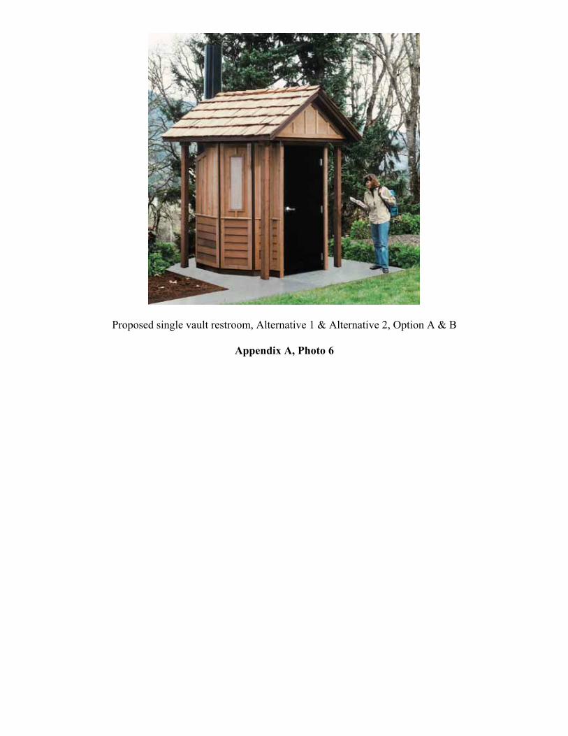
Proposed single vault restroom, Alternative 1 & Alternative 2, Option A & B
Appendix A, Photo 6

Watmough Bay EA
Light vegetation removal
Resurface access road With 0.75 inch gravel
Drivable drainages
Proposed access road improvements, Alternative 1 & Alternative 2, Option A & B
Appendix A, Photo 7

Proposed Bollards
Large Boulders, recessed 1/3 rd their size
Removal of gate and creosote posts
Watmough Bay EA
Proposed gate and post removal, bollard and boulder placement, Alternative 1 & Alternative 2, Option A and B
Appendix A, Photo 8

Clean and define existing ditch line
Resurface parking area with 0.75 inch gravel
Watmough Bay EA
Proposed ditch cleaning, Alternative 1 & 2, Option A& B
Appendix A, Photo 9

Watmough Bay EA
Trees selected for removal=
Proposed Tree Removal, Alternative 2, Option B
Appendix A, Photo 10

Trees selected for removal=
Watmough Bay EA
Proposed Tree Removal, Alternative 2, Option B
Appendix A, Photo 11

Trees selected for removal=
Watmough Bay EA
Proposed Tree Removal, Alternative 2, Option B
Appendix A, Photo 12
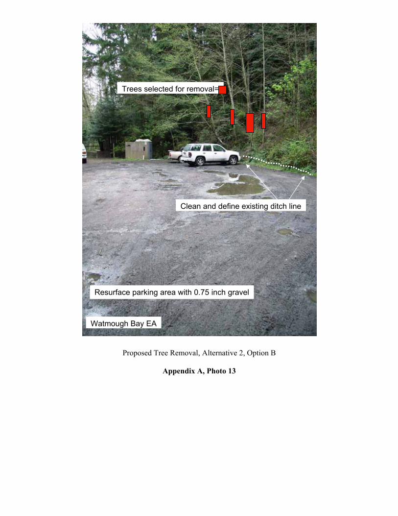
Clean and define existing ditch line
Trees selected for removal=
Resurface parking area with 0.75 inch gravel
Watmough Bay EA
Proposed Tree Removal, Alternative 2, Option B
Appendix A, Photo 13

Proposed site of Restroom, Alt 2, option B With large boulders=
Gate and creosote post removal
Proposed Bollards
Resurface parking area with 0.75 inch gravel
Watmough Bay EA
Proposed elements, Alternative 2, Option B
Appendix A, Photo 14

Alternative 3: No action
Watmough Bay EA
Alternative 3, No Action
Appendix A, Photo 15

Appendix B
Watmough Bay Trailhead Improvements EA # OR 134-05-012
Parking Area, approx 50’ x 100’ Ditch line
Trail
Culvert
Wetlands area
Trail
Watmough Head Road Access road
Drainage dips
Gate with Creosote posts
Sign Wooden bike rack
Portable restroom
Drawing not to scale
Existing elements Appendix B, Drawing 1

Appendix B
Watmough Bay Trailhead Improvements EA # OR 134-05-012
Parking Area, approx 50’ x 100’, add gravel, level
Ditch line, clean and define
Trail
Culvert
Wetlands area
Trail
Watmough Head Road Access road
Drainage dips, clean, define
Bollards, 3 each, wooden
Kiosk, sign Wooden bike rack, 2 each, wooden
new restroom
Drawing not to scale
boulders
boulders
Parking area enlargement, light vegetation and tree removal
Proposed elements, Alternative 1
Appendix B, Drawing 2

Appendix B
Watmough Bay Trailhead Improvements EA # OR 134-05-012
Parking Area, approx 50’ x 100’, add gravel, level
Ditch line, clean and define
Trail
Culvert
Wetlands area
Trail
Watmough Head Road
Access road, light vegetation clearing
Drainage dips, clean, define
Bollards, 3 each, wooden
Kiosk and sign Wooden bike rack, 2 each, wooden
new restroom
boulders
Built up area for restroom
boulders
Drawing not to scale
Proposed elements, Alternative 2, Option A
Appendix B, Drawing 3

Appendix B
Watmough Bay Trailhead Improvements EA # OR 134-05-012
Parking Area, approx 50’ x 100’, add gravel, level
Ditch line, clean and define
Trail
Culvert
Wetlands area
Trail
Watmough Head Road Access road, light vegetation clearing
Drainage dips, clean, define
Bollards, 3 each, wooden
Kiosk and sign
Wooden bike rack, 2 each, wooden
new restroom
Drawing not to scale
boulders
boulders
Selected tree removal
Proposed elements, Alternative 2, Option B
Appendix B, Drawing 4

Appendix B
Watmough Bay Trailhead Improvements EA # OR 134-05-012
6” inch, diameter, smooth round, wooden post
48”- 60” inches span
No Vehicles
No Vehicles
No Vehicles
Ground level, grade
Lock
Plastic casing
4’ feet above grade
Lock Lock
2’ feet below grade
Bollards, removable, wooden
Appendix B, Drawing 5

100
200
300
400
R1W
T0T3
4NT3
4N
WA S H I N G T O N
San Juan Islands
SpokaneWenatchee
Appendix C, Watmough Bay - Project Site Map
0 300 600 900150Feet
No warranty is made by the Bureau of Land Management as to the accuracy,reliability, or completeness of these data for individual or aggregate usewith other data. Original data were compiled from various sources. Thisinformation may not meet National Map Accuracy Standards. This productwas developed through digital means and may be updated without notification.
Project Area
Lopez Island
Trails
San Juan Roads
BLM Lands Contour Interval 20ft
Wa
t mo
ug
h B
ay
W a t m o u g h H e a d R o a d
CH
AD
WI C
K H
I LL
W A T M O U G H H E A D
Project Area


![[XLS] · Web viewSAETTONE WATMOUGH RICHARD DOUGLAS 0230060881937 698 10082527708 MARCHENA MURGA DE JAUREGUI LILIA FLORIDA 0230060851045 699 0230060988151 700 10082530032 GRIFFIS CORDREY](https://static.fdocuments.in/doc/165x107/5ba323f209d3f2d14d8d64fe/xls-web-viewsaettone-watmough-richard-douglas-0230060881937-698-10082527708.jpg)