Waterloo Comprehensive Plan - Bremer County, IowaZ/Bremer-County... · Bremer County, Iowa...
46
Bremer County, Iowa Comprehensive Land Use Plan Update Recommended for Adoption by the Planning and Zoning Commission on April 15, 2003 Adopted by the Board of Supervisors on May 5, 2003 Prepared by the Iowa Northland Regional Council of Governments
Transcript of Waterloo Comprehensive Plan - Bremer County, IowaZ/Bremer-County... · Bremer County, Iowa...
Bremer County, Iowa Comprehensive Land Use Plan Update
Recommended for Adoption by the Planning and Zoning Commission on April 15, 2003
Adopted by the Board of Supervisors on May 5, 2003
Prepared by the Iowa Northland Regional Council of Governments
Bremer County Comprehensive Land Use Plan Update
TABLE OF CONTENTS
Purpose of Comprehensive Planning.............................................................................................................................1 Overview of the Comprehensive Plan.............................................................................................................1
History of the County ....................................................................................................................................................2
Physical Characteristics of the County ..........................................................................................................................3
Location...........................................................................................................................................................3 Topography .....................................................................................................................................................3 Soils.................................................................................................................................................................3
Statistical Profile – Historical Trends and Forecasts .....................................................................................................7 Population .......................................................................................................................................................7 Housing ........................................................................................................................................................11 Economy .......................................................................................................................................................15 Financial........................................................................................................................................................20
Public Facilities ...........................................................................................................................................................23 County Government ......................................................................................................................................23 Fire and Rescue Services...............................................................................................................................25 County Conservation Board ..........................................................................................................................25 Arts and Culture ............................................................................................................................................26 Education.......................................................................................................................................................26 Libraries ........................................................................................................................................................27
Public Utilities .............................................................................................................................................................32 Water .............................................................................................................................................................32 On-Site Septic Systems .................................................................................................................................32 Electricity, Natural Gas, Telephone ..............................................................................................................32 Solid Waste ...................................................................................................................................................32 Flood Control ................................................................................................................................................32
Circulation and Transportation ....................................................................................................................................34 Roads/Streets.................................................................................................................................................34 Air .................................................................................................................................................................34 Rail ................................................................................................................................................................34 Transit ...........................................................................................................................................................34 Water .............................................................................................................................................................34 Bike and Pedestrian.......................................................................................................................................34
Recent Planning Efforts...............................................................................................................................................37 Hazard Mitigation Plan .................................................................................................................................37 Extraterritorial Agreement with Waverly......................................................................................................37
Implementation of the Plan..........................................................................................................................................38
Land Use Goals and Objectives ....................................................................................................................38 Future Growth and Development ..................................................................................................................41
Amendment of the Plan ...............................................................................................................................................43
i
Bremer County Comprehensive Land Use Plan Update
LIST OF FIGURES 1. Location of the County...........................................................................................................................................4 2. Topography of the County......................................................................................................................................5 3. Corn Suitability Ratings for Soils in the County ....................................................................................................6 4. Bremer County Census Tracts................................................................................................................................8 5. County Services Locations ...................................................................................................................................28 6. Fire Departments ..................................................................................................................................................29 7. County Conservation Areas..................................................................................................................................30 8. Education and Library Facilities...........................................................................................................................31 9. Flood Prone Areas of the County .........................................................................................................................33 10. Transportation Modes/Infrastructure in the County .............................................................................................35 11. Recreational Trail Map of the County ..................................................................................................................36 12. Future Land Use Map of the County ....................................................................................................................42
LIST OF TABLES 1. Historical Population Trends for Bremer County and the State of Iowa ................................................................7 2. Population Trends of Selected Communities .........................................................................................................7 3. Age Cohorts for Bremer County ............................................................................................................................9 4. Persons Under the Age of 18 and Over the Age of 64............................................................................................9 5. Race and Sex of Bremer County Residents............................................................................................................9 6. Population Projections for Bremer County...........................................................................................................10 7. General Housing Information for Bremer County................................................................................................11 8. Number of Housing Units in Selected Communities............................................................................................11 9. Age of Housing Units in 2000..............................................................................................................................12 10. Value of Specified Owner-Occupied Units in Bremer County.............................................................................12 11. Median Value of a Specified Owner-Occupied Units in Selected Communities .................................................13 12. Number of Specified Renter Occupied Units for Selected Communities.............................................................13 13. Median Rent for Selected Communities...............................................................................................................14 14. Housing Unit Projections for Bremer County ......................................................................................................14 15. Economic Base of Bremer County and State of Iowa in 2000 .............................................................................15 16. Occupation Classification of Persons Employed in 2000.....................................................................................15 17. Number and Average Size of Farms in Bremer County .......................................................................................16 18. Land in Farms and Acres Harvested in Bremer County .......................................................................................16 19. Corn Production in Bremer County......................................................................................................................16 20. Soybean Production in Bremer County ................................................................................................................16 21. Cattle Statistics for Bremer County......................................................................................................................17 22. Hog and Pig Production in Bremer County..........................................................................................................17 23. Per Capita and Median Household Income for Selected Communities................................................................18 24. Unemployment Rate Trends by Year ...................................................................................................................18 25. Educational Attainment for Persons 25 Years of Age and Older in 2000 ............................................................18 26. Retail Trade in Bremer County and State of Iowa................................................................................................19 27. Service Industries in Bremer County and State of Iowa.......................................................................................19 28. Wholesale Trade in Bremer County and State of Iowa ........................................................................................19 29. Taxable and Actual Valuation Statistics for Bremer County................................................................................20 30. County Annual Report Revenue Trends...............................................................................................................20 31. County Annual Report Expenditure and Fund Balance Trends............................................................................21 32. General Obligation Bond Debt Analysis ..............................................................................................................21 33. Tax Rates for Selected Communities in Bremer County......................................................................................22
ii
Bremer County Comprehensive Land Use Plan Update
PURPOSE OF COMPREHENSIVE PLANNING Overview of the Comprehensive Plan Comprehensive planning, as a process, is very complex while the purpose of comprehensive planning is simple. The process requires that elected officials, staff-members, volunteers, and the general public attempt to define relevant policies as well as set land use direction for their county for a period of time up to several decades in length. The purpose is for the county to attempt to study itself, in broad fashion, and set a course of future direction for development. Often the term “comprehensive plan” is used synonymously with other terms such as comprehensive land use plan, general plan, or master plan. For the purpose of this document, we will use the terms Comprehensive Land Use Plan or Comprehensive Plan, which is the term most recognized by the Code of Iowa. We should begin by defining what we mean by comprehensive plan or comprehensive planning. Webster’s Dictionary defines “comprehensive” as “inclusive”. “Planning” is defined as, “the act or process of making or carrying out plans; the establishment of goals, policies, and procedures for a social or economic unit”. In addition, Webster goes on to define “plan” as a, “method devised for making or doing something or achieving an end”, and that it “always implies mental formulation and sometimes graphic representation”. In short, a Comprehensive Plan is an inclusive, broad means of achieving a desired end. In this case, it is a written land use policy instrument that includes graphic representations or illustrations. The Plan itself includes several processes, including adoption, amendment, and goal and policy development. A Comprehensive Plan seeks to promote cost-effective, efficient, logical growth in a county. It should manage growth by balancing the good of the county and the rights of the private property owner, rather than encourage growth that is left unchecked or stifle growth through unnecessary regulations and procedures. The Plan should prevent, or at the very least discourage, sprawling and/or leapfrogging development. It should attempt to minimize future conflicts between incompatible uses in the county by defining future land use patterns. And throughout, the Plan should remain the long-range foundation for county regulations and policies regarding its physical development over a useful life of as much as 20 years. The State of Iowa, in the Code of Iowa, has provided the basis for planning in Chapter 335. This Chapter is commonly referred to as the State’s enabling legislation because it empowers counties to plan and regulate their physical development. Although the Code subsection pertaining to comprehensive plans is brief, it implies that a comprehensive plan be the basis of zoning regulations. Specifically, it states that regulations are to be in “accordance with a comprehensive plan”. Furthermore, the Code also, in the Chapters governing platting and subdivision of land and urban renewal, requires that these activities be consistent with a county’s comprehensive plan. In short, comprehensive planning is the conscious process of developing the county’s land development plan, and it includes studying past and present trends, as well as setting goals and defining policies that will shape the physical development of the community. It is a circular process of decision-making that should be continually refined and updated to reflect the county’s goals and policies. Ultimately, the intent of the Plan is to be a statement of land use goals and policies, a guide for local growth and development, as well as meet the statutory requirements of the Code of Iowa. However, we must recognize that a comprehensive plan and comprehensive planning process are only as good as the implementation tools adopted by the county. Likewise, elected officials and administrators have to enforce the regulations and implement their plans in a uniform and consistent manner. To do so requires a commitment of personnel and financial resources through the county budgeting process. Any shortfall in the allocation of personnel and/or financial resources may result in the county failing to meet its goals and/or haphazardly applying its policies. The Plan has the following Sections: the above stated Purpose and Intent; the History of the County; Physical Characteristics of the County; Statistical Profile; Public Facilities; Public Utilities; Circulation and Transportation; Land Use; Implementation; and Amendment Procedures.
1
Bremer County Comprehensive Land Use Plan Update
HISTORY OF THE COUNTY In 1833, Bremer County and surrounding area were ceded to the Winnebago tribe by the U.S. government in exchange for land in Illinois and $10,000. At the time of the first settlement in 1845, there were approximately 650 members of the Winnebago, Mesquakie, and Pottawattamie tribes living in the county. First settlers included Charles McCafree, Jacob Beelah, J.H. Messinger, George Tibbetts, T. Fisher, and P. Miller. In 1848, the Native Americans remaining in Bremer County were removed by U.S. government troops to areas west of Bremer County, and in 1850, a treaty was signed that included provisions moving the tribes out of the Iowa territory. Bremer County, which was named for a Swedish author, Frederika Bremer, was surveyed into townships in 1847, and in 1848 the first township, Jefferson Township, was divided into sections. And by 1851, the entire county was sectionalized and placed onto the market for sale or homesteading. The first community platted was Janesville and the plat was recorded on July 22, 1854. Development closely followed the platting of Janesville. Elections were first held in 1851, and public education began in a log cabin in Jefferson Township during the winter of 1852-1853. Higher education came to the county with the establishment of Wartburg College in 1879. The first newspaper, the Bremer County Herald, was printed in Janesville in 1855. Bremer County built its first courthouse, a 20 foot by 30 foot building, in 1854 at a cost of $147.50. As in many northeastern Iowa counties, the railroad had a dramatic influence on development in the 1860s and 1870s. The railroads offered a means of transportation for people, agricultural commodities, and other materials. During this era, the county was crisscrossed by the Illinois Central; Iowa and Pacific; and Dubuque; and Dakota Railroad lines. The communities of Tripoli, Sumner, and Plainfield were developed as railroad towns. During the 1920s through 1940s, the county made contributions to the war efforts and was economically affected by the Great Depression. The air station south of Waverly provided employment for military and service personnel and added to the economy of the surrounding cities of Waverly and Janesville. Today, the county includes eight incorporated communities that are separated by areas of land that is prime for agriculture. And while highways have picked up where railroads have disappeared, Bremer County enjoys access to a notable transportation network. The County Seat is located in Waverly in the southwestern part of the county. Education, family values, and a strong work ethic remain hallmarks of the residents of Bremer County.
2
Bremer County Comprehensive Land Use Plan Update
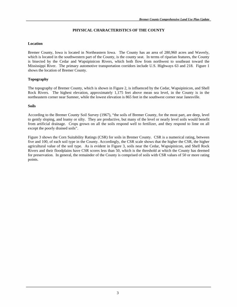
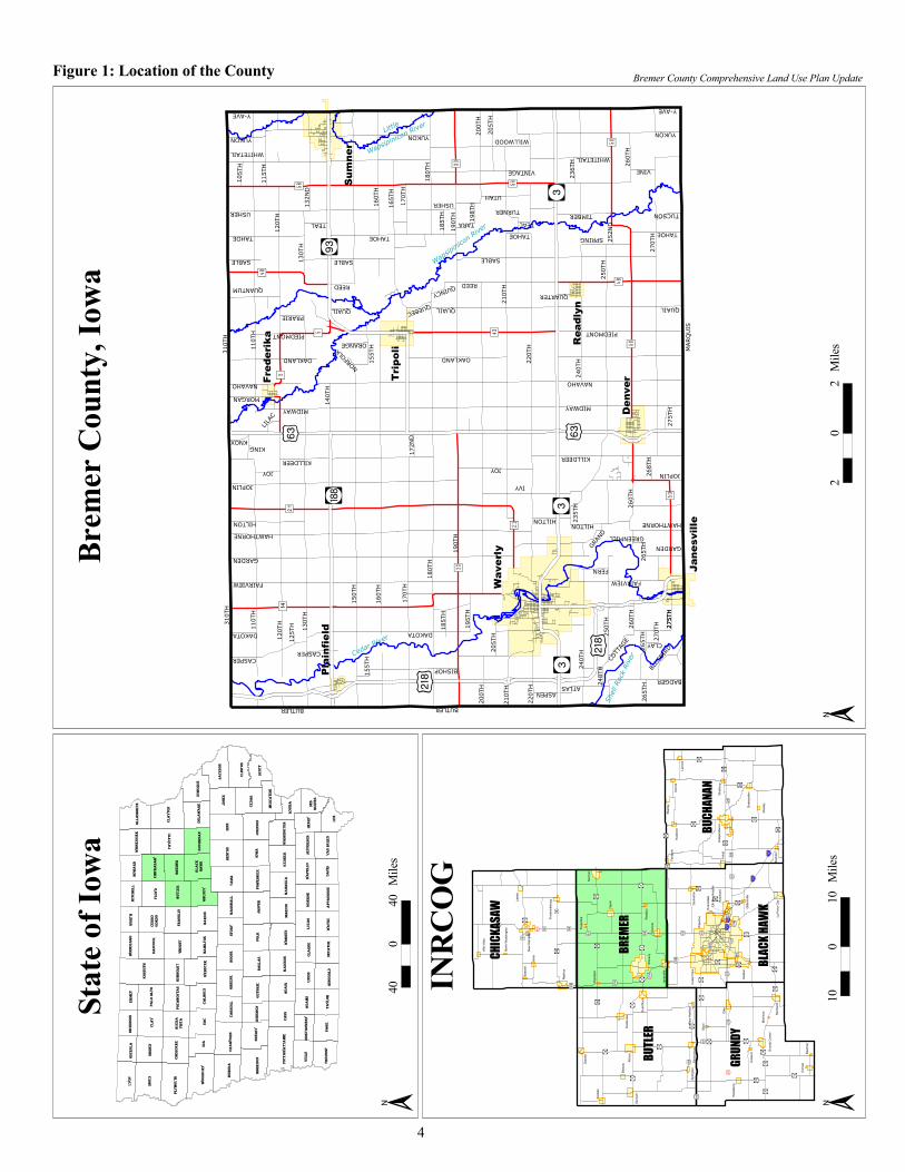
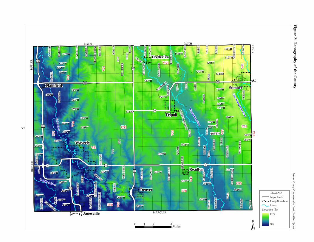
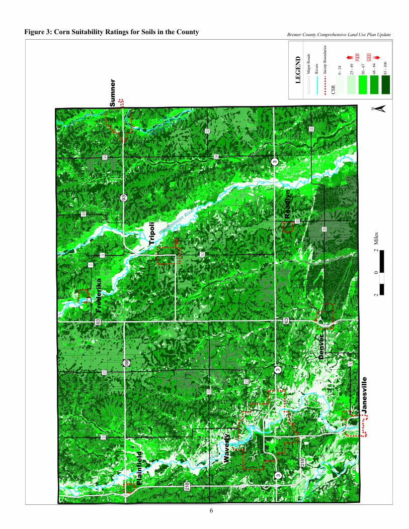
PHYSICAL CHARACTERISTICS OF THE COUNTY Location Bremer County, Iowa is located in Northeastern Iowa. The County has an area of 280,960 acres and Waverly, which is located in the southwestern part of the County, is the county seat. In terms of riparian features, the County is bisected by the Cedar and Wapsipinicon Rivers, which both flow from northwest to southeast toward the Mississippi River. The primary automotive transportation corridors include U.S. Highways 63 and 218. Figure 1 shows the location of Bremer County. Topography The topography of Bremer County, which is shown in Figure 2, is influenced by the Cedar, Wapsipinicon, and Shell Rock Rivers. The highest elevation, approximately 1,175 feet above mean sea level, in the County is in the northeastern corner near Sumner, while the lowest elevation is 865 feet in the southwest corner near Janesville. Soils According to the Bremer County Soil Survey (1967), “the soils of Bremer County, for the most part, are deep, level to gently sloping, and loamy or silty. They are productive, but many of the level or nearly level soils would benefit from artificial drainage. Crops grown on all the soils respond well to fertilizer, and they respond to lime on all except the poorly drained soils”. Figure 3 shows the Corn Suitability Ratings (CSR) for soils in Bremer County. CSR is a numerical rating, between five and 100, of each soil type in the County. Accordingly, the CSR scale shows that the higher the CSR, the higher agricultural value of the soil type. As is evident in Figure 3, soils near the Cedar, Wapsipinicon, and Shell Rock Rivers and their floodplains have CSR scores less than 50, which is the threshold at which the County has deemed for preservation. In general, the remainder of the County is comprised of soils with CSR values of 50 or more rating points.
3
����
������
��
����
��
�������
��
��
��� �
��
�����
���
������
����
����� ��
����
�����
����
������
���������
� ����
������
����
����
������ ���
��������
�� ����
� ���� ���
�������
����
����
����
��������
����
����
����
��� ����� ���
������
�����
�����
�������
�����
�����
�����
���������������
�����
����������
��������
�����������������
������
������
�����
�������
�����
�����
�����
���
���������
�����
�����
����
������
�����
�����
�������
�����
���������������
��������
�������
�����
������
������
������
�����
����� ����� �����
���
���������
����� �����
����� �����
�����
���������
�����
����
���
������
����
���
�����
��� �
��
������
����� �����������
������
�����
����������
����
������
�����
����
������
�������
�������
����
�����
����� �����
�����
�����
�����
�����
�����
�����
�����
�����
�����
� ���
� ���
�����
�����
�!���
�!���
� ���
�"���
�"���
�#���
�#���
�"���
�"���
�����
�����
�#���
�#"��
�����
�����
�����
�����
�����
�����
�����
�� ��
�������
�����
�����
��"��
�����
�����
���������� ���
�������
� ���
� ���
� ��� �!���
� ���
� "��
� ���
����
���
�!���
�!���
�������
�!���
�!���
����
�!��
����
����
�������
��
����
����
���
����
��
��� ��
�������
����
�������
���
�����
����
���
��
���
���
����
���������
������
����
���
���
����
���
����
�
����
���
����
���
����
� ��
����
���
� ��
�����
����
������
� ��
����
�����
����
������
��
� ����
� �
� �
����
����
�������
� ����
������
��
���
���
����
���
�����
���
�����
����
���
���
���
���
����
����
������
����
����
����
������
����
���
����
����
���
����
���
����
��
������
����
���
�����
������
� �
���
� ����
����
���
������
���
���
����
���
������
�����
� ����
��
������
����
��
����
�������
����
��
��
��
����
������
����
��
�����
�� ��
����
������
����
����
���
���
������
���
���
����
���
����
�� ��
���
����
���
�����
����
���
����
������
���
����
�����
���
����
����
� �
����
���
����
���
���
����
�������
��
����
����
���
����
��
��� ��
�������
����
�������
���
�����
����
���
��
���
���
����
���������
������
����
���
���
����
���
����
�
����
���
����
���
����
� ��
����
���
� ��
�����
����
������
� ��
����
�����
����
������
��
� ����
� �
� �
����
����
�������
� ����
������
��
���
���
����
���
�����
���
�����
����
���
���
���
���
����
����
������
����
����
����
������
����
���
����
����
���
����
���
����
��
������
����
���
�����
������
� �
���
� ����
����
���
������
���
���
����
���
������
�����
� ����
��
������
����
��
����
�������
����
��
��
��
����
������
����
��
�����
�� ��
����
������
����
����
���
���
������
���
���
����
���
����
�� ��
���
����
���
�����
����
���
����
������
���
����
�����
���
����
����
� �
����
���
����
���
���
����
��
����
����
����
��
��
����
�
�
�� �
��
�� �
�
��
�� ���
��
����
���� ����
����
��
��
����
����
����
��
��
���� �
���
��
����
��
�����
��
��
����
�
���� ��
��
��
���
��
�� ��
����
��
��
��
�� ��
��
�����
�
����
�
���
��
����
� �
�� �
��� �
�
�����
� �
����
��
�����
����
�������
�����
������
������
����
��
�����
������������
����
���
��
!��"�������
��#���
����
$���%
���
������
&�����
&�����������
����������
�����%��'
��(��
��
"����
��%��'
��������
)���*���
�
����������
�����+����
�����
����
��������
�%��'
���%���
��������
,������
,�����
"����
-����
&��%�
�������
������
�����
'��
.��������
���
��
$���
��
����
������$��
�������
!�#���
,����#
����
!��
��
�����'�
�
.���$
������'
���
$#���
�������
��#���
��-��
$������
������
�������
,���
��
/�����
����
����������� �
���
������
�
����
����
���
����
�
���
������
��
��
����
�
� ��
���������������� �������������� ����� ����������������������������
�
����������������������������
JanesvilleJanesville
WaverlyWaverly
DenverDenver
ReadlynReadlyn
TripoliTripoli
SumnerSumner
FrederikaFrederika
PlainfieldPlainfield
V14
V14
V21
V21
V21V21
V14
V14
T77
T77
C50C50
C50C50
C33C33
V5CV5C
V25
V25
V43
V43
V49
V49
C50C50
V62
V62
V56
V56
V62
V62
310TH310TH 310TH310TH
110TH110TH
120TH120TH
125TH125TH
130TH130TH 132ND132ND
115TH115TH
105TH105TH
140TH140TH
150TH150TH
155TH155TH
160TH160TH
170TH170TH
180TH180TH
190TH190TH185TH185TH
172ND172ND
195TH195TH
200TH200TH
210TH210TH
205TH205TH
220TH220TH
240TH240TH
250TH250TH
235TH235TH
260TH260TH
265TH265TH
270TH270TH
275TH275TH
268TH268TH
110TH110TH
120TH120TH
130TH130TH
150TH150TH
160TH160TH
170TH170TH
165TH165TH
155TH155TH
180TH180TH
185TH185TH
190TH190TH
200TH200TH
C33C33
198TH198TH
205TH205TH
210TH210TH
220TH220TH
240TH240TH236TH236TH
252ND252ND250TH250TH
260TH260TH
270TH270TH
275TH275TH
MARQUISMARQUIS
LILAC
LILAC
BLUEBIRD
BLUEBIRD
GRAND
GRAND
NORFOLK
NORFOLK
QU
EB
EC
QU
EB
EC
QU
INC
YQ
UIN
CY
BU
TL
ER
BU
TL
ER
BU
TL
ER
BU
TL
ER
CA
SPE
RC
ASP
ER
DA
KO
TA
DA
KO
TA
FAIR
VIE
WFA
IRV
IEW
GA
RD
EN
GA
RD
EN
HA
WT
HO
RN
EH
AW
TH
OR
NE
HIL
TO
NH
ILT
ON
JOPL
INJO
PLIN
JOY
JOY
KIL
LD
EE
RK
ILL
DE
ER
KIN
GK
ING
KN
OX
KN
OX
MO
RG
AN
MO
RG
AN
NA
VA
HO
NA
VA
HO
MID
WA
YM
IDW
AY
OA
KL
AN
DO
AK
LA
ND PI
ED
MO
NT
PIE
DM
ON
T
PRA
IRIE
PRA
IRIE
QU
AN
TU
MQ
UA
NT
UM
SAB
LE
SAB
LE
TA
HO
ET
AH
OE
USH
ER
USH
ER
WH
ITE
TA
ILW
HIT
ET
AIL
YU
KO
NY
UK
ON
Y-A
VE
Y-A
VE
TE
AL
TE
AL
RE
ED
RE
ED
QU
AIL
QU
AIL
OR
AN
GE
OR
AN
GE
TA
RA
TA
RA
QU
AR
TE
RQ
UA
RT
ER
TU
RN
ER
TU
RN
ER
UT
AH
UT
AH
VIN
TA
GE
VIN
TA
GE
WIL
WO
OD
WIL
WO
OD
TIM
BE
RT
IMB
ER
SPR
ING
SPR
ING
VIN
EV
INE
TU
CSO
NT
UC
SON
ASP
EN
ASP
EN
AT
LA
SA
TL
AS
CL
AY
CL
AY
BA
DG
ER
BA
DG
ER
FER
NFE
RN
IVY
IVY
GR
EE
NM
ILL
GR
EE
NM
ILL
265TH265TH
CA
SPE
RC
ASP
ER
DA
KO
TA
DA
KO
TA
FAIR
VIE
WFA
IRV
IEW
GA
RD
EN
GA
RD
EN
HA
WT
HO
RN
EH
AW
TH
OR
NE
HIL
TO
NH
ILT
ON
JOPL
INJO
PLIN
JOY
JOY
KIL
LD
EE
RK
ILL
DE
ER
MID
WA
YM
IDW
AY
NA
VA
HO
NA
VA
HO
PIE
DM
ON
TPI
ED
MO
NT
QU
AIL
QU
AIL
RE
ED
RE
ED
SAB
LE
SAB
LE
SAB
LE
SAB
LE
TA
HO
ET
AH
OE
TA
HO
ET
AH
OE
TE
AL
TE
AL
TA
HO
ET
AH
OE
USH
ER
USH
ER
WH
ITE
TA
ILW
HIT
ET
AIL
YU
KO
NY
UK
ON
YU
KO
NY
UK
ON
Y-A
VE
Y-A
VE
Cedar R
iverC
edar River
Shell Rock River
Shell Rock River
Little W
apsipinicon River
Little W
apsipinicon River
Wapsipinicon R
iver
Wapsipinicon R
iver
Figure 2: T
opography of the County
Brem
er County C
omprehensive L
and Use P
lan Update
LEGEND
Elevation (ft)
Major Roads
Incorp Boundaries
Rivers
1175
865
5
0 2 41Miles
���������������� �������������� ����� ����������������������������
�
����
����
��
��
����
��
������
����
����
��
���
�����
���
������
������
�����
��
����
��
������
������
���������
� ����
������
����
����
������ ���
��������
�� ����
� ���� ���
� ��� ��
� ���
� ���
� ���� ���
� ���
� ���
� ���
� ���
� ���
� ���
� ���
��
��
����
�
���������������� ����� ���� ���������������� ����� �
���
��
����
���
�
��
�
���
���
������
���
�����
��������
����
������
����
��
� �
����
����
Bremer County Comprehensive Land Use Plan Update
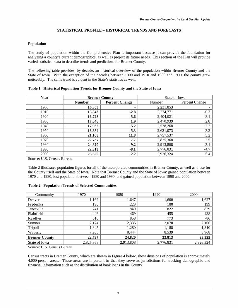
STATISTICAL PROFILE – HISTORICAL TRENDS AND FORECASTS Population The study of population within the Comprehensive Plan is important because it can provide the foundation for analyzing a county’s current demographics, as well as project its future needs. This section of the Plan will provide varied statistical data to describe trends and predictions for Bremer County. The following table provides, by decade, an historical overview of the population within Bremer County and the State of Iowa. With the exception of the decades between 1900 and 1910 and 1980 and 1990, the county grew noticeably. The same trend is evident in the State’s statistics as well. Table 1. Historical Population Trends for Bremer County and the State of Iowa
Bremer County State of Iowa Year Number Percent Change Number Percent Change
1900 16,305 - 2,231,853 - 1910 15,843 -2.8 2,224,771 -0.3 1920 16,728 5.6 2,404,021 8.1 1930 17,046 1.9 2,470,939 2.8 1940 17,932 5.2 2,538,268 2.7 1950 18,884 5.3 2,621,073 3.3 1960 21,108 11.8 2,757,537 5.2 1970 22,737 7.7 2,825,368 2.5 1980 24,820 9.2 2,913,808 3.1 1990 22,813 -8.1 2,776,831 -4.7 2000 23,325 2.2 2,926,324 5.4
Source: U.S. Census Bureau Table 2 illustrates population figures for all of the incorporated communities in Bremer County, as well as those for the County itself and the State of Iowa. Note that Bremer County and the State of Iowa: gained population between 1970 and 1980; lost population between 1980 and 1990; and gained population between 1990 and 2000. Table 2. Population Trends of Selected Communities
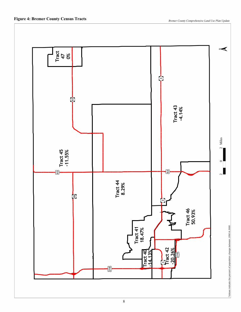
Community 1970 1980 1990 2000 Denver 1,169 1,647 1,600 1,627 Frederika 190 223 188 199 Janesville 741 840 822 829 Plainfield 446 469 455 438 Readlyn 616 858 773 786 Sumner 2,174 2,335 2,078 2,106 Tripoli 1,345 1,280 1,188 1,310 Waverly 7,205 8,444 8,539 8,968 Bremer County 22,737 24,820 22,813 23,325 State of Iowa 2,825,368 2,913,808 2,776,831 2,926,324 Source: U.S. Census Bureau Census tracts in Bremer County, which are shown in Figure 4 below, show divisions of population is approximately 4,000-person areas. These areas are important in that they serve as jurisdictions for tracking demographic and financial information such as the distribution of bank loans in the County.
7
����
����
��
��
����
���������
����
�
�������
�� �
�
�������
�����
�������
���
���
�������
� � �
�
�������
�
���
�����
�� ��
�������
����
�
��
�����
�
�
���������������� �������������� ����� ���������������������������������������������� ����� ����������
�
�����
����
������� ����
���
������
��������
�� �
��������
�����
������
���
Bremer County Comprehensive Land Use Plan Update
Table 3 focuses on the population cohorts that were reported in the 1990 and 2000 Censuses of the County. In general, this table shows that persons under the age of 35 declined, while persons over the age of 35 increased in number. With further analysis, it becomes apparent that the percentage of change in each cohort underscores the significance of the decline shown by the actual numbers. Table 3. Age Cohorts for Bremer County
1990 2000 Age Cohort Number % of Total Number % of Total
% Change
Less than 5 1,378 6.0 1,291 5.5 -6.3 5-9 1,678 7.4 1,532 6.6 -8.7 10-14 1,708 7.5 1,673 7.2 -2.0 15-19 1,903 8.3 2,175 9.3 14.3 20-24 1,756 7.7 1,754 7.5 -0.1 25-34 2,911 12.8 2,309 9.9 -20.7 35-44 3,226 14.1 3,272 14.0 1.4 45-54 2,482 10.9 3,176 13.6 28.0 55-64 1,965 8.6 2,410 10.3 22.6 65-74 1,970 8.6 1,696 7.3 -13.9 75-84 1,324 5.8 1,432 6.1 8.2 85+ 512 2.2 605 2.6 18.2 Total 22,813 100.0 23,325 100.0 2.2 Source: U.S. Census Bureau In an attempt to predict how change in certain age cohorts may affect the future need for services in the County, Table 4 has been developed. Specifically, it analyzes trends for persons under the age of 18 and over the age of 64 for the two decades shown. Note that the number of persons under the age of 18 decreased in the County and increased statewide, while the percentage of persons under the age of 18 in both jurisdictions decreased. The number of persons over the age of 64 decreased in the County and increased in the State, while the percentages for both jurisdictions remained fairly stable. Table 4. Persons Under the Age of 18 and Over the Age of 64
1990 2000 Community <18 % >64 % <18 % >64 %
Bremer County 5,762 25.3 3,806 16.7 5,627 24.1 3,733 16.0 State of Iowa 718,880 25.9 426,106 15.3 733,638 25.1 436,213 14.9 Source: U.S. Census Bureau Further review of Census Bureau information, regarding race and sex of the County’s population, is shown in Table 5. In 1990, the County was a relatively homogenous, while in 2000 it became more diverse. Table 5. Race and Sex of Bremer County Residents Total
Population White or Caucasian
Black or African American
Am. Indian, Eskimo, Aleut
Asian or Pacific Islander
Other Race/ 2+ Races
Male (1990) 11,105 10,996 62 2 39 6 Female (1990) 11,708 11,626 11 0 57 14 Total (1990) 22,813 22,622 73 2 96 20 Male (2000) 11,274 11,068 61 11 52 82 Female (2000) 12,051 11,841 51 4 74 81 Total (2000) 23,325 22,909 112 15 126 163 Source: U.S. Census Bureau
9
Bremer County Comprehensive Land Use Plan Update
The following table shows 20-year population projections for Bremer County. It should be noted that all of the projections use historical information as their basis. An explanation of each type follows. The two types of projections that were calculated by INRCOG for this Plan, Linear and Geometric, are straight-line or averaging methods of predicting population change. Linear projections use the actual change in the total number of persons over a predetermined period of time in the County. Conversely, Geometric projections use the percent change the County has experienced over a set number of years. For both of these projection types, this study used trend information from two time periods, between 1900 and 2000 and between 1940 and 2000, as the basis for the figures shown in Table 6. Table 6 also includes projections provided by Woods and Poole Economics, Incorporated for the years 2010 and 2020. It is important to note that the Woods and Poole projections are significantly less than the calculated projections. Table 6 provides a summary of the projection results for the years 2010 and 2020, and the projections show modest growth for the county for 2010 and 2020. By way of comparison, the County had a 1990 population of 22,813 persons and a 2000 population of 23,325. Finally, it is important to remember that the information shown in Table 6 is merely a projection of the County’s future population calculated using historical data rather than an exact number persons who will actually be living in Bremer County at that time. Table 6. Population Projections for Bremer County
Type of Projection 2010 2020 Linear
1900-2000 24,027 24,729 1940-2000 24,223 25,121
Geometric 1900-2000 24,211 25,131 1940-2000 24,397 25,520
Woods & Poole 23,610 24,130 Mean or Average 24,094 24,926 Source: U.S. Census Bureau, INRCOG, and Woods and Poole Economics, Inc.
10
Bremer County Comprehensive Land Use Plan Update
Housing In addition to studying population statistics, a Comprehensive Plan should review pertinent housing data. As is the case for many Iowa counties, the predominant type of housing in Bremer County is the single-family home. In addition, the average number of persons living in each unit is less than three persons, and the vacancy rate is relatively low (5%). A summary of general housing information is shown in Table 7. Table 7. General Housing Information for Bremer County
Statistic 1980 1990 2000 Total Persons 24,820 22,813 23,325 Total Housing Units 8,811 8,847 9,337
Occupied 8,454 8,394 8,860 Vacant 357 453 477
Persons Per Housing Unit 2.82 2.58 2.50 Number of Households 8,454 8,413 8,860 Number of Families 6,593 6,242 6,324 Source: U.S. Census Bureau Table 8 shows the number of housing units reported, by selected communities, in the 1980, 1990, and 2000 Censuses. Note that all of the cities, the County, and the State of Iowa all gained housing units between the 1990 and 2000 Censuses. Table 8. Number of Housing Units in Selected Communities
Community 1980 1990 2000 Denver 590 622 672 Frederika 110 119 122 Janesville 307 334 359 Plainfield 203 193 202 Readlyn 309 305 326 Sumner 945 900 930 Tripoli 536 558 561 Waverly 2,985 3,160 3,394 Bremer County 8,811 8,847 9,337 State of Iowa 1,121,314 1,143,669 1,232,511 Source: U.S. Census Bureau
11
Bremer County Comprehensive Land Use Plan Update
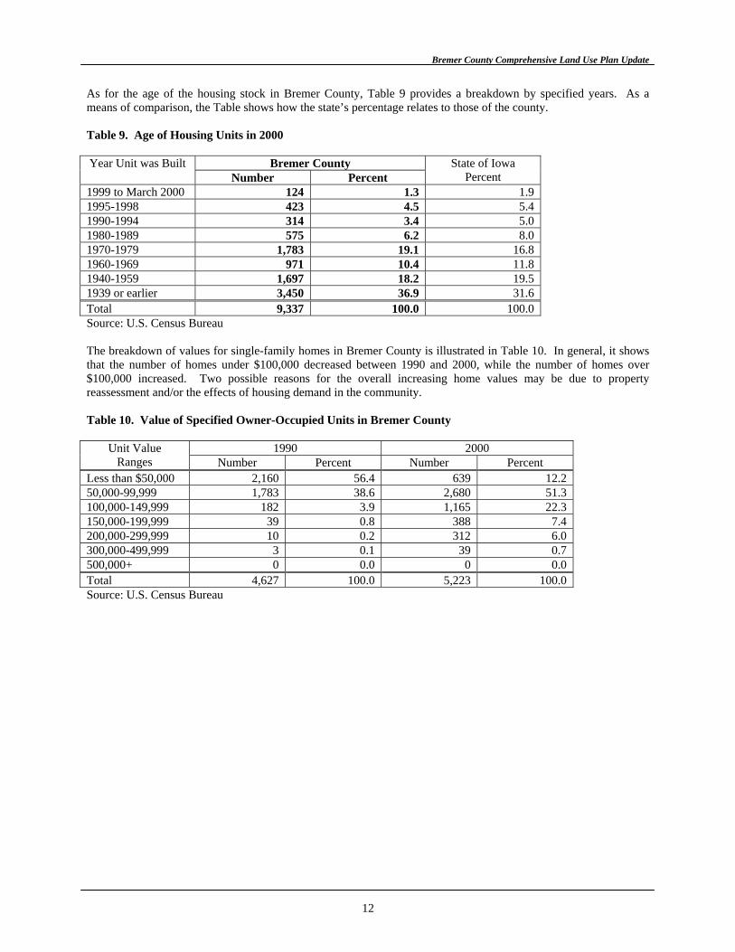
As for the age of the housing stock in Bremer County, Table 9 provides a breakdown by specified years. As a means of comparison, the Table shows how the state’s percentage relates to those of the county. Table 9. Age of Housing Units in 2000
Bremer County Year Unit was Built Number Percent
State of Iowa Percent
1999 to March 2000 124 1.3 1.9 1995-1998 423 4.5 5.4 1990-1994 314 3.4 5.0 1980-1989 575 6.2 8.0 1970-1979 1,783 19.1 16.8 1960-1969 971 10.4 11.8 1940-1959 1,697 18.2 19.5 1939 or earlier 3,450 36.9 31.6 Total 9,337 100.0 100.0 Source: U.S. Census Bureau The breakdown of values for single-family homes in Bremer County is illustrated in Table 10. In general, it shows that the number of homes under $100,000 decreased between 1990 and 2000, while the number of homes over $100,000 increased. Two possible reasons for the overall increasing home values may be due to property reassessment and/or the effects of housing demand in the community. Table 10. Value of Specified Owner-Occupied Units in Bremer County
1990 2000 Unit Value Ranges Number Percent Number Percent
Less than $50,000 2,160 56.4 639 12.2 50,000-99,999 1,783 38.6 2,680 51.3 100,000-149,999 182 3.9 1,165 22.3 150,000-199,999 39 0.8 388 7.4 200,000-299,999 10 0.2 312 6.0 300,000-499,999 3 0.1 39 0.7 500,000+ 0 0.0 0 0.0 Total 4,627 100.0 5,223 100.0 Source: U.S. Census Bureau
12
Bremer County Comprehensive Land Use Plan Update
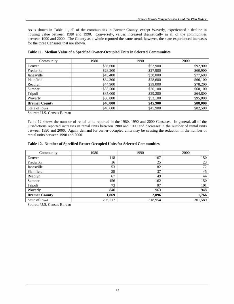
As is shown in Table 11, all of the communities in Bremer County, except Waverly, experienced a decline in housing value between 1980 and 1990. Conversely, values increased dramatically in all of the communities between 1990 and 2000. The County as a whole reported the same trend, however, the state experienced increases for the three Censuses that are shown. Table 11. Median Value of a Specified Owner-Occupied Units in Selected Communities
Community 1980 1990 2000 Denver $56,600 $53,900 $92,900 Frederika $29,200 $27,900 $60,900 Janesville $45,400 $38,000 $77,600 Plainfield $34,300 $28,600 $66,100 Readlyn $44,900 $39,000 $78,200 Sumner $33,500 $30,100 $68,100 Tripoli $35,000 $29,200 $64,800 Waverly $50,800 $53,100 $95,800 Bremer County $46,800 $45,900 $88,000 State of Iowa $40,600 $45,900 $82,500 Source: U.S. Census Bureau Table 12 shows the number of rental units reported in the 1980, 1990 and 2000 Censuses. In general, all of the jurisdictions reported increases in rental units between 1980 and 1990 and decreases in the number of rental units between 1990 and 2000. Again, demand for owner-occupied units may be causing the reduction in the number of rental units between 1990 and 2000. Table 12. Number of Specified Renter Occupied Units for Selected Communities
Community 1980 1990 2000 Denver 118 167 150 Frederika 16 25 23 Janesville 53 82 72 Plainfield 38 37 45 Readlyn 67 49 44 Sumner 156 162 150 Tripoli 73 97 101 Waverly 840 963 948 Bremer County 1,869 2,096 1,766 State of Iowa 296,512 318,954 301,589 Source: U.S. Census Bureau
13
Bremer County Comprehensive Land Use Plan Update
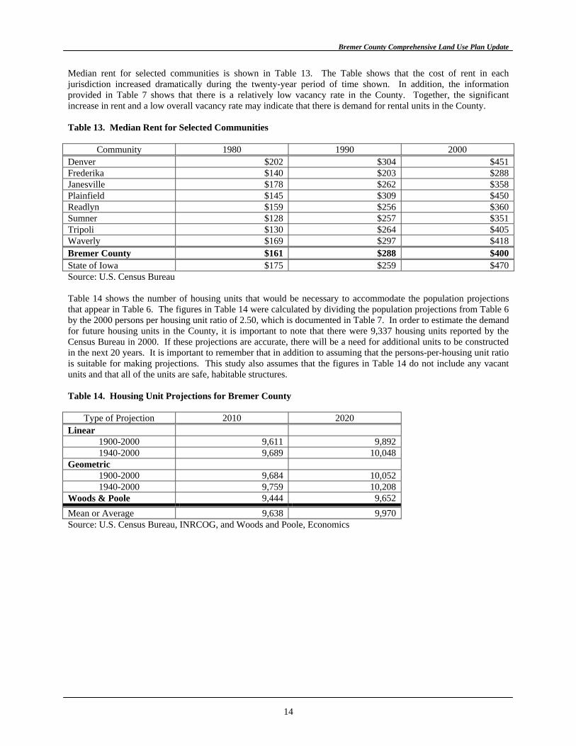
Median rent for selected communities is shown in Table 13. The Table shows that the cost of rent in each jurisdiction increased dramatically during the twenty-year period of time shown. In addition, the information provided in Table 7 shows that there is a relatively low vacancy rate in the County. Together, the significant increase in rent and a low overall vacancy rate may indicate that there is demand for rental units in the County. Table 13. Median Rent for Selected Communities
Community 1980 1990 2000 Denver $202 $304 $451 Frederika $140 $203 $288 Janesville $178 $262 $358 Plainfield $145 $309 $450 Readlyn $159 $256 $360 Sumner $128 $257 $351 Tripoli $130 $264 $405 Waverly $169 $297 $418 Bremer County $161 $288 $400 State of Iowa $175 $259 $470 Source: U.S. Census Bureau Table 14 shows the number of housing units that would be necessary to accommodate the population projections that appear in Table 6. The figures in Table 14 were calculated by dividing the population projections from Table 6 by the 2000 persons per housing unit ratio of 2.50, which is documented in Table 7. In order to estimate the demand for future housing units in the County, it is important to note that there were 9,337 housing units reported by the Census Bureau in 2000. If these projections are accurate, there will be a need for additional units to be constructed in the next 20 years. It is important to remember that in addition to assuming that the persons-per-housing unit ratio is suitable for making projections. This study also assumes that the figures in Table 14 do not include any vacant units and that all of the units are safe, habitable structures. Table 14. Housing Unit Projections for Bremer County
Type of Projection 2010 2020 Linear
1900-2000 9,611 9,892 1940-2000 9,689 10,048
Geometric 1900-2000 9,684 10,052 1940-2000 9,759 10,208
Woods & Poole 9,444 9,652 Mean or Average 9,638 9,970 Source: U.S. Census Bureau, INRCOG, and Woods and Poole, Economics
14
Bremer County Comprehensive Land Use Plan Update
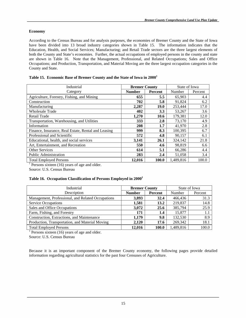
Economy According to the Census Bureau and for analysis purposes, the economies of Bremer County and the State of Iowa have been divided into 13 broad industry categories shown in Table 15. The information indicates that the Education, Health, and Social Services; Manufacturing; and Retail Trade sectors are the three largest elements of both the County and State’s economies. Further, the actual occupations of employed persons in the county and state are shown in Table 16. Note that the Management, Professional, and Related Occupations; Sales and Office Occupations; and Production, Transportation, and Material Moving are the three largest occupation categories in the County and State. Table 15. Economic Base of Bremer County and the State of Iowa in 20001
Bremer County State of Iowa Industrial
Category Number Percent Number Percent Agriculture, Forestry, Fishing, and Mining 655 5.5 65,903 4.4 Construction 702 5.8 91,824 6.2 Manufacturing 2,287 19.0 253,444 17.0 Wholesale Trade 402 3.3 53,267 3.6 Retail Trade 1,270 10.6 179,381 12.0 Transportation, Warehousing, and Utilities 333 2.8 73,170 4.9 Information 208 1.7 41,970 2.8 Finance, Insurance, Real Estate, Rental and Leasing 999 8.3 100,395 6.7 Professional and Scientific 572 4.8 90,157 6.1 Educational, health, and social services 3,141 26.1 324,142 21.8 Art, Entertainment, and Recreation 550 4.6 98,819 6.6 Other Services 614 5.1 66,286 4.4 Public Administration 283 2.4 51,058 3.4 Total Employed Persons 12,016 100.0 1,489,816 100.0 1 Persons sixteen (16) years of age and older. Source: U.S. Census Bureau Table 16. Occupation Classification of Persons Employed in 20001
Bremer County State of Iowa Industrial
Description Number Percent Number Percent Management, Professional, and Related Occupations 3,893 32.4 466,436 31.3 Service Occupations 1,581 13.2 219,837 14.8 Sales and Office Occupations 3,072 25.6 385,794 25.9 Farm, Fishing, and Forestry 171 1.4 15,877 1.1 Construction, Extractions, and Maintenance 1,179 9.8 132,530 8.9 Production, Transportation, and Material Moving 2,120 17.6 269,342 18.1 Total Employed Persons 12,016 100.0 1,489,816 100.0 1 Persons sixteen (16) years of age and older. Source: U.S. Census Bureau Because it is an important component of the Bremer County economy, the following pages provide detailed information regarding agricultural statistics for the past four Censuses of Agriculture.
15
Bremer County Comprehensive Land Use Plan Update
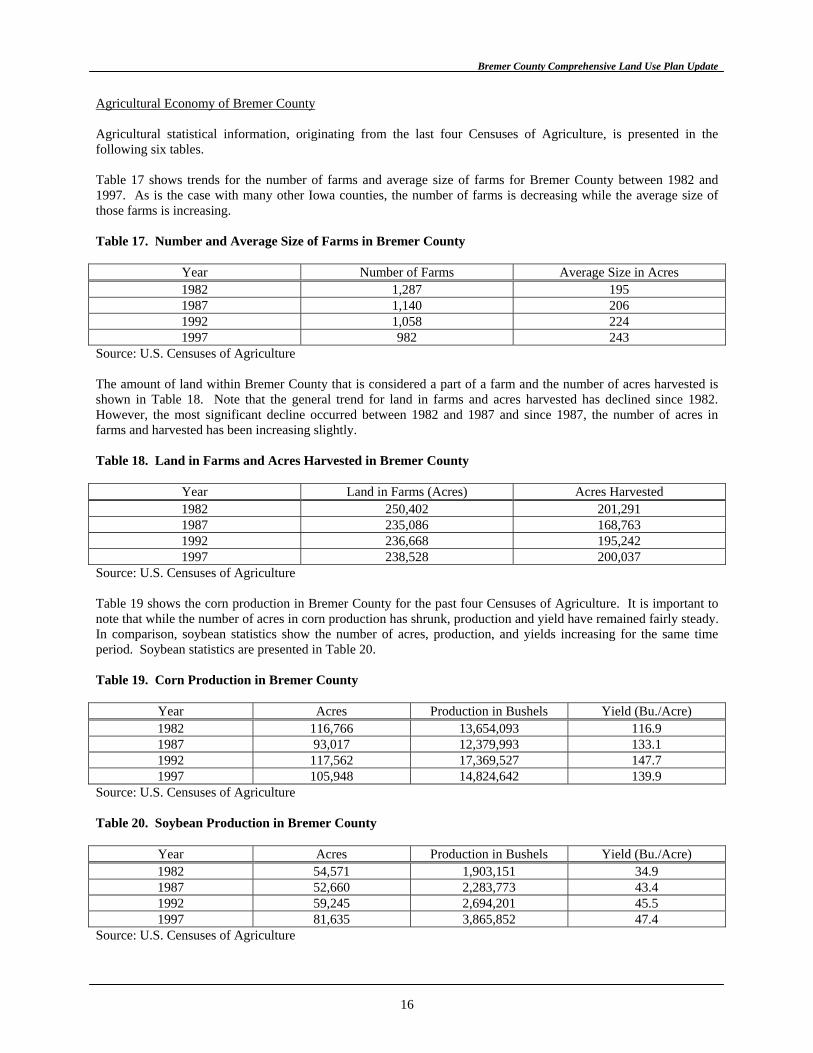
Agricultural Economy of Bremer County Agricultural statistical information, originating from the last four Censuses of Agriculture, is presented in the following six tables. Table 17 shows trends for the number of farms and average size of farms for Bremer County between 1982 and 1997. As is the case with many other Iowa counties, the number of farms is decreasing while the average size of those farms is increasing. Table 17. Number and Average Size of Farms in Bremer County
Year Number of Farms Average Size in Acres 1982 1,287 195 1987 1,140 206 1992 1,058 224 1997 982 243
Source: U.S. Censuses of Agriculture The amount of land within Bremer County that is considered a part of a farm and the number of acres harvested is shown in Table 18. Note that the general trend for land in farms and acres harvested has declined since 1982. However, the most significant decline occurred between 1982 and 1987 and since 1987, the number of acres in farms and harvested has been increasing slightly. Table 18. Land in Farms and Acres Harvested in Bremer County
Year Land in Farms (Acres) Acres Harvested 1982 250,402 201,291 1987 235,086 168,763 1992 236,668 195,242 1997 238,528 200,037
Source: U.S. Censuses of Agriculture Table 19 shows the corn production in Bremer County for the past four Censuses of Agriculture. It is important to note that while the number of acres in corn production has shrunk, production and yield have remained fairly steady. In comparison, soybean statistics show the number of acres, production, and yields increasing for the same time period. Soybean statistics are presented in Table 20. Table 19. Corn Production in Bremer County
Year Acres Production in Bushels Yield (Bu./Acre) 1982 116,766 13,654,093 116.9 1987 93,017 12,379,993 133.1 1992 117,562 17,369,527 147.7 1997 105,948 14,824,642 139.9
Source: U.S. Censuses of Agriculture Table 20. Soybean Production in Bremer County
Year Acres Production in Bushels Yield (Bu./Acre) 1982 54,571 1,903,151 34.9 1987 52,660 2,283,773 43.4 1992 59,245 2,694,201 45.5 1997 81,635 3,865,852 47.4
Source: U.S. Censuses of Agriculture
16
Bremer County Comprehensive Land Use Plan Update
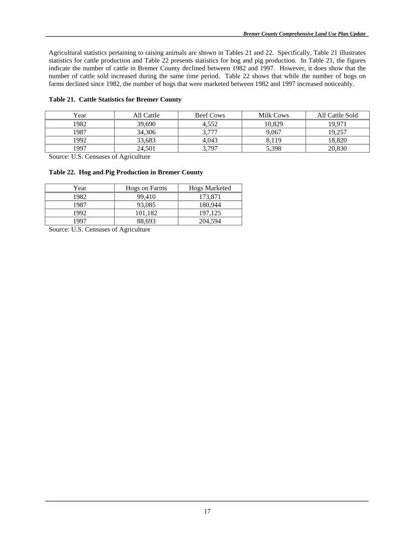
Agricultural statistics pertaining to raising animals are shown in Tables 21 and 22. Specifically, Table 21 illustrates statistics for cattle production and Table 22 presents statistics for hog and pig production. In Table 21, the figures indicate the number of cattle in Bremer County declined between 1982 and 1997. However, it does show that the number of cattle sold increased during the same time period. Table 22 shows that while the number of hogs on farms declined since 1982, the number of hogs that were marketed between 1982 and 1997 increased noticeably. Table 21. Cattle Statistics for Bremer County
Year All Cattle Beef Cows Milk Cows All Cattle Sold 1982 39,690 4,552 10,829 19,971 1987 34,306 3,777 9,067 19,257 1992 33,683 4,043 8,119 18,820 1997 24,501 3,797 5,398 20,830
Source: U.S. Censuses of Agriculture Table 22. Hog and Pig Production in Bremer County
Year Hogs on Farms Hogs Marketed 1982 99,410 173,871 1987 93,085 180,944 1992 101,182 197,125 1997 88,693 204,594
Source: U.S. Censuses of Agriculture
17
Bremer County Comprehensive Land Use Plan Update
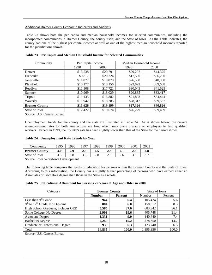
Additional Bremer County Economic Indicators and Analysis Table 23 shows both the per capita and median household incomes for selected communities, including the incorporated communities in Bremer County, the county itself, and the State of Iowa. As the Table indicates, the county had one of the highest per capita incomes as well as one of the highest median household incomes reported for the jurisdictions shown. Table 23. Per Capita and Median Household Income for Selected Communities
Community Per Capita Income Median Household Income 1990 2000 1990 2000 Denver $13,538 $20,791 $29,292 $44,375 Frederika $9,817 $20,224 $17,500 $36,250 Janesville $11,077 $18,878 $26,538 $40,060 Plainfield $10,177 $18,156 $23,092 $39,688 Readlyn $11,508 $17,721 $30,043 $41,625 Sumner $10,969 $18,029 $20,885 $33,417 Tripoli $11,135 $16,882 $21,893 $34,444 Waverly $11,942 $18,285 $28,312 $39,587 Bremer County $11,626 $19,199 $27,326 $40,826 State of Iowa $12,422 $19,674 $26,229 $39,469 Source: U.S. Census Bureau Unemployment trends for the county and the state are illustrated in Table 24. As is shown below, the current unemployment rates for both jurisdictions are low, which may place pressure on employers to find qualified workers. Except in 1999, the County’s rate has been slightly lower than that of the State for the period shown. Table 24. Unemployment Rate Trends by Year
Community 1995 1996 1997 1998 1999 2000 2001 2002 Bremer County 3.0 2.9 2.5 2.5 2.8 2.1 2.8 2.8 State of Iowa 3.5 3.8 3.3 2.8 2.6 2.6 3.3 3.7 Source: Iowa Workforce Development The following table compares the levels of education for persons within the Bremer County and the State of Iowa. According to this information, the County has a slightly higher percentage of persons who have earned either an Associates or Bachelors degree than those in the State as a whole. Table 25. Educational Attainment for Persons 25 Years of Age and Older in 2000
Bremer County State of Iowa Category Number Percent Number Percent
Less than 9th Grade 944 6.4 105,424 5.6 9th to 12th Grade, No Diploma 884 6.0 158,012 8.3 High School Graduate, includes GED 5,585 37.6 683,942 36.1 Some College, No Degree 2,903 19.6 405,748 21.4 Associate Degree 1,331 9.0 140,640 7.4 Bachelors Degree 2,249 15.2 278,350 14.7 Graduate or Professional Degree 939 6.3 123,740 6.5 Total 14,835 100.0 1,895,856 100.0 Source: U.S. Census Bureau
18
Bremer County Comprehensive Land Use Plan Update
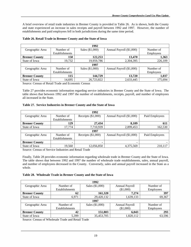
A brief overview of retail trade industries in Bremer County is provided in Table 26. As is shown, both the County and state experienced an increase in sales receipts and payroll between 1992 and 1997. However, the number of establishments and paid employees fell in both jurisdictions during the same time period. Table 26. Retail Trade in Bremer County and the State of Iowa
1992 Geographic Area Number of
Establishments Sales ($1,000) Annual Payroll ($1,000) Number of
Employees Bremer County 150 122,253 13,470 1,363 State of Iowa 19,732 19,959,786 2,304,395 226,109
1997 Geographic Area Number of
Establishments Sales ($1,000) Annual Payroll ($1,000) Number of
Employees Bremer County 115 144,729 13,720 1,037 State of Iowa 14,695 26,723,822 2,633,445 175,694 Source: Census of Retail Trade and Economic Census Table 27 provides economic information regarding service industries in Bremer County and the State of Iowa. The table shows that between 1992 and 1997 the number of establishments, receipts, payroll, and number of employees all increased in the State. Table 27. Service Industries in Bremer County and the State of Iowa
1992 Geographic Area Number of
Establishments Receipts ($1,000) Annual Payroll ($1,000) Paid Employees
Bremer County 129 27,434 8,109 611 State of Iowa 17,774 7,710,939 2,899,453 162,530
1997 Geographic Area Number of
Establishments Receipts ($1,000) Annual Payroll ($1,000) Paid Employees
Bremer County - - - - State of Iowa 19,560 12,056,850 4,375,569 210,117 Source: Census of Service Industries and Retail Trade Finally, Table 28 provides economic information regarding wholesale trade in Bremer County and the State of Iowa. The table shows that between 1992 and 1997 the number of wholesale trade establishments, sales, annual payroll, and number of employees decreased in the County. Conversely, sales and annual payroll increased in the State as a whole. Table 28. Wholesale Trade in Bremer County and the State of Iowa
1992 Geographic Area Number of
Establishments Sales ($1,000) Annual Payroll
($1,000) Number of Employees
Bremer County 62 161,320 7,274 397 State of Iowa 6,971 29,420,132 1,639,133 69,367
1997 Geographic Area Number of
Establishments Sales ($1,000) Annual Payroll
($1,000) Number of Employees
Bremer County 42 151,803 6,043 293 State of Iowa 5,399 35,453,705 1,820,112 63,596 Source: Census of Wholesale Trade and Retail Trade
19
Bremer County Comprehensive Land Use Plan Update
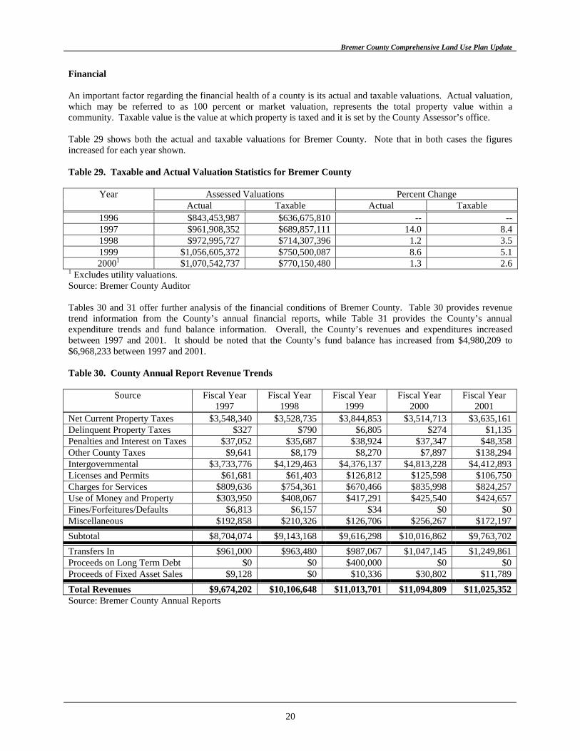
Financial An important factor regarding the financial health of a county is its actual and taxable valuations. Actual valuation, which may be referred to as 100 percent or market valuation, represents the total property value within a community. Taxable value is the value at which property is taxed and it is set by the County Assessor’s office. Table 29 shows both the actual and taxable valuations for Bremer County. Note that in both cases the figures increased for each year shown. Table 29. Taxable and Actual Valuation Statistics for Bremer County
Assessed Valuations Percent Change Year Actual Taxable Actual Taxable
1996 $843,453,987 $636,675,810 -- -- 1997 $961,908,352 $689,857,111 14.0 8.4 1998 $972,995,727 $714,307,396 1.2 3.5 1999 $1,056,605,372 $750,500,087 8.6 5.1 20001 $1,070,542,737 $770,150,480 1.3 2.6
1 Excludes utility valuations. Source: Bremer County Auditor Tables 30 and 31 offer further analysis of the financial conditions of Bremer County. Table 30 provides revenue trend information from the County’s annual financial reports, while Table 31 provides the County’s annual expenditure trends and fund balance information. Overall, the County’s revenues and expenditures increased between 1997 and 2001. It should be noted that the County’s fund balance has increased from $4,980,209 to $6,968,233 between 1997 and 2001. Table 30. County Annual Report Revenue Trends
Source Fiscal Year 1997
Fiscal Year 1998
Fiscal Year 1999
Fiscal Year 2000
Fiscal Year 2001
Net Current Property Taxes $3,548,340 $3,528,735 $3,844,853 $3,514,713 $3,635,161 Delinquent Property Taxes $327 $790 $6,805 $274 $1,135 Penalties and Interest on Taxes $37,052 $35,687 $38,924 $37,347 $48,358 Other County Taxes $9,641 $8,179 $8,270 $7,897 $138,294 Intergovernmental $3,733,776 $4,129,463 $4,376,137 $4,813,228 $4,412,893 Licenses and Permits $61,681 $61,403 $126,812 $125,598 $106,750 Charges for Services $809,636 $754,361 $670,466 $835,998 $824,257 Use of Money and Property $303,950 $408,067 $417,291 $425,540 $424,657 Fines/Forfeitures/Defaults $6,813 $6,157 $34 $0 $0 Miscellaneous $192,858 $210,326 $126,706 $256,267 $172,197 Subtotal $8,704,074 $9,143,168 $9,616,298 $10,016,862 $9,763,702 Transfers In $961,000 $963,480 $987,067 $1,047,145 $1,249,861 Proceeds on Long Term Debt $0 $0 $400,000 $0 $0 Proceeds of Fixed Asset Sales $9,128 $0 $10,336 $30,802 $11,789 Total Revenues $9,674,202 $10,106,648 $11,013,701 $11,094,809 $11,025,352 Source: Bremer County Annual Reports
20
Bremer County Comprehensive Land Use Plan Update
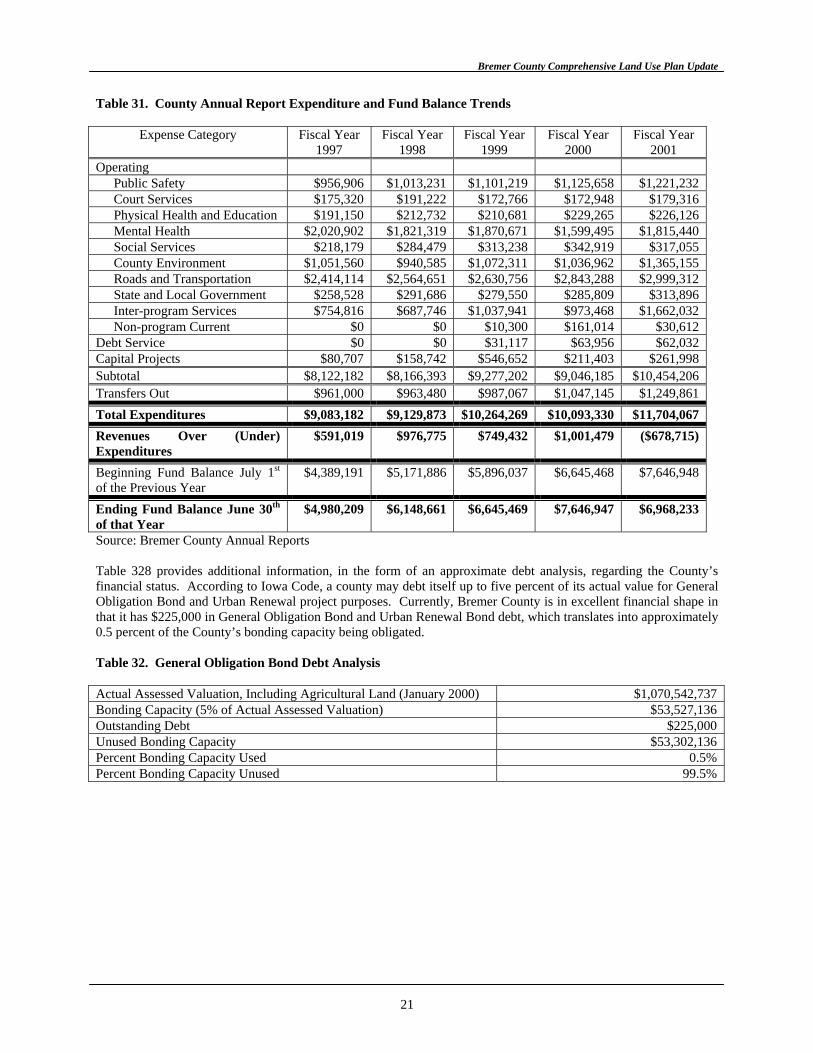
Table 31. County Annual Report Expenditure and Fund Balance Trends
Expense Category Fiscal Year 1997
Fiscal Year 1998
Fiscal Year 1999
Fiscal Year 2000
Fiscal Year 2001
Operating Public Safety $956,906 $1,013,231 $1,101,219 $1,125,658 $1,221,232 Court Services $175,320 $191,222 $172,766 $172,948 $179,316 Physical Health and Education $191,150 $212,732 $210,681 $229,265 $226,126 Mental Health $2,020,902 $1,821,319 $1,870,671 $1,599,495 $1,815,440 Social Services $218,179 $284,479 $313,238 $342,919 $317,055 County Environment $1,051,560 $940,585 $1,072,311 $1,036,962 $1,365,155 Roads and Transportation $2,414,114 $2,564,651 $2,630,756 $2,843,288 $2,999,312 State and Local Government $258,528 $291,686 $279,550 $285,809 $313,896 Inter-program Services $754,816 $687,746 $1,037,941 $973,468 $1,662,032 Non-program Current $0 $0 $10,300 $161,014 $30,612
Debt Service $0 $0 $31,117 $63,956 $62,032 Capital Projects $80,707 $158,742 $546,652 $211,403 $261,998 Subtotal $8,122,182 $8,166,393 $9,277,202 $9,046,185 $10,454,206 Transfers Out $961,000 $963,480 $987,067 $1,047,145 $1,249,861 Total Expenditures $9,083,182 $9,129,873 $10,264,269 $10,093,330 $11,704,067 Revenues Over (Under) Expenditures
$591,019 $976,775 $749,432 $1,001,479 ($678,715)
Beginning Fund Balance July 1st of the Previous Year
$4,389,191 $5,171,886 $5,896,037 $6,645,468 $7,646,948
Ending Fund Balance June 30th of that Year
$4,980,209 $6,148,661 $6,645,469 $7,646,947 $6,968,233
Source: Bremer County Annual Reports Table 328 provides additional information, in the form of an approximate debt analysis, regarding the County’s financial status. According to Iowa Code, a county may debt itself up to five percent of its actual value for General Obligation Bond and Urban Renewal project purposes. Currently, Bremer County is in excellent financial shape in that it has $225,000 in General Obligation Bond and Urban Renewal Bond debt, which translates into approximately 0.5 percent of the County’s bonding capacity being obligated. Table 32. General Obligation Bond Debt Analysis Actual Assessed Valuation, Including Agricultural Land (January 2000) $1,070,542,737 Bonding Capacity (5% of Actual Assessed Valuation) $53,527,136 Outstanding Debt $225,000 Unused Bonding Capacity $53,302,136 Percent Bonding Capacity Used 0.5% Percent Bonding Capacity Unused 99.5%
21
Bremer County Comprehensive Land Use Plan Update
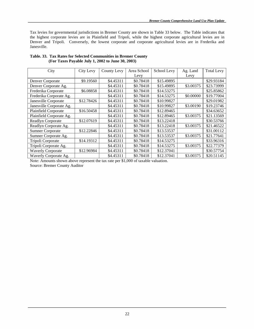
Tax levies for governmental jurisdictions in Bremer County are shown in Table 33 below. The Table indicates that the highest corporate levies are in Plainfield and Tripoli, while the highest corporate agricultural levies are in Denver and Tripoli. Conversely, the lowest corporate and corporate agricultural levies are in Frederika and Janesville. Table. 33. Tax Rates for Selected Communities in Bremer County
(For Taxes Payable July 1, 2002 to June 30, 2003)
City City Levy County Levy Area School Levy
School Levy Ag. Land Levy
Total Levy
Denver Corporate $9.19560 $4.45311 $0.78418 $15.49895 $29.93184 Denver Corporate Ag. $4.45311 $0.78418 $15.49895 $3.00375 $23.73999 Frederika Corporate $6.08858 $4.45311 $0.78418 $14.53275 $25.85862 Frederika Corporate Ag. $4.45311 $0.78418 $14.53275 $0.00000 $19.77004 Janesville Corporate $12.78426 $4.45311 $0.78418 $10.99827 $29.01982 Janesville Corporate Ag. $4.45311 $0.78418 $10.99827 $3.00190 $19.23746 Plainfield Corporate $16.50458 $4.45311 $0.78418 $12.89465 $34.63652 Plainfield Corporate Ag. $4.45311 $0.78418 $12.89465 $3.00375 $21.13569 Readlyn Corporate $12.07619 $4.45311 $0.78418 $13.22418 $30.53766 Readlyn Corporate Ag. $4.45311 $0.78418 $13.22418 $3.00375 $21.46522 Sumner Corporate $12.22846 $4.45311 $0.78418 $13.53537 $31.00112 Sumner Corporate Ag. $4.45311 $0.78418 $13.53537 $3.00375 $21.77641 Tripoli Corporate $14.19312 $4.45311 $0.78418 $14.53275 $33.96316 Tripoli Corporate Ag. $4.45311 $0.78418 $14.53275 $3.00375 $22.77379 Waverly Corporate $12.96984 $4.45311 $0.78418 $12.37041 $30.57754 Waverly Corporate Ag. $4.45311 $0.78418 $12.37041 $3.00375 $20.51145 Note: Amounts shown above represent the tax rate per $1,000 of taxable valuation. Source: Bremer County Auditor
22
Bremer County Comprehensive Land Use Plan Update
PUBLIC FACILITIES AND SERVICES
County Government The Bremer County Courthouse, the location of which is shown in Figure 5, is located on Bremer Avenue in the City of Waverly. Within the County’s organizational structure, there are many offices that provide a variety of service to the public. The following subsections provide brief overviews of each office’s responsibilities. Assessor The Assessor is charged with several administrative and statutory duties. The primary duty and responsibility is to make sure all real property is assessed, except where the law provides otherwise. This includes all residential, commercial, industrial, and agricultural classes of property. Real property is reevaluated every two years. The effective date of the assessment is the first day of January of the current year. The Assessor determines either a full or partial value for new construction and improvements depending upon their state of completion at the beginning of January. Auditor The Auditor has a variety of responsibilities including: conducting elections, preparing payroll for the County, issuing warrants, updating maps after property transactions, calculating levies, assists townships with the preparation of their budgets, providing research, clerking for the Board of Supervisors, prepares information to be included with property tax statements, and other duties as may be needed. Building and Zoning The mission of this Department is to promote public health, safety, comfort, order and the general welfare by considering and protecting the natural and manmade environment. In addition, minimum standards are enforced in order to safeguard life or limb, health, property and public welfare by regulating and controlling the design, construction, quality of materials, use and occupancy, location and maintenance of buildings in the unincorporated portion of Bremer County. The Department, under contract, provides building and zoning code enforcement to the communities of Denver, Janesville, Readlyn, and Tripoli. Emergency Management The purpose of the Emergency Management Department is to support, coordinate, and maintain local emergency management and preparedness activities. This includes preparing and monitoring grants, organizing training sessions, and providing coordination and assistance to government assistance to governing officials when an emergency or disaster occurs. Future needs include purchasing additional outdoor warning sirens, maintaining mutual aid agreements with surrounding communities, purchasing and installing Global Positioning Systems (GPS) in all emergency vehicles, and purchasing and installing National Oceanic and Atmospheric Administration (NOAA) early warning radios in schools, nursing homes, and hospitals. Engineer The Bremer County Engineer’s office is responsible for the supervision of all construction and maintenance work performed on all Secondary Roads within the County. Bremer County’s road system includes approximately 720 miles of roads, of which 135 miles are paved. There are also approximately 225 bridges over 20 feet in length.
23
Bremer County Comprehensive Land Use Plan Update
The County Engineer’s office is responsible for design and construction of all road and bridge projects in the road system. All permits pertaining to use of the roadway are issued from the office. These include moving permits for oversize and over-length truckloads, work within the right-of-way, underground utility permits, and approval of driveways and field entrances. The County Highway Department is responsible for general maintenance on all county roads. This also includes installing traffic signs; maintaining road surfaces; ditch drainage in the road right-of-way; and vegetation and winter snow and ice control. Geographic Information Systems Created in 2000, the Bremer County Geographic Information System (GIS) Department manages spatial and location base information for the purpose of providing methods for collecting and analyzing data to support decision-making processes within all County offices as well as for the citizens of Bremer County. Data is compiled from fact based decisions and documents, and used in both day-to-day operational needs and long range planning. By maintaining the Bremer County cadastral base map, the GIS Department is also the connecting link between other County offices because 90 percent of the County information is geographically based. The Department is also dedicated to promote increased awareness about GIS technology and applications to the public and private agencies as well as other government offices. Home Care Program The purpose of this Program is to prevent or delay nursing home placement and offer assistance to individuals who have recently been discharged from the hospital. Also, through supportive services by trained and supervised paraprofessionals, assist with the preservation of families in need. Services include but are not limited to: assistance with bathing, hair care, walking, range of motion, respite care, meal preparation, grocery and essential shopping, light housekeeping, laundry, family and money management, parenting, as well as active listening and emotional support. While the majority of clients are elderly, the program is available to any Bremer County resident who is in need of assistance. Services are offered on sliding fee scale, supported by a grant from the Iowa Department of Public Health. Recorder The Recorder/Registrar records and maintains on file deeds, mortgages, contracts, condemnations, easements, federal and state tax liens, surveys, plat proceedings, trade names, UCC filings, Articles of Incorporation, military service records, and other miscellaneous documents. The Recorder also collects real estate transfer tax for the Iowa Department of Revenue, issues hunting and fishing licenses, registers and titles boats, snowmobiles, all terrain vehicles for the Department of Natural Resources, conducts federal and state tax lien searches. The Recorder’s office issues all marriage licenses as well as registers birth, death, and marriage certificates and is a United States Passport Agent assisting in completing and mailing applications for passports. Sheriff The Bremer County Sheriff’s Department consists of the Sheriff and ten deputies, all of which have their own vehicles. In addition to law enforcement activities in the unincorporated areas of the County, the Department provides patrol and police service to the communities of Frederika and Plainfield. The Bremer County jail is located in the Bremer-Waverly Law Center in the city of Waverly. The jail has the capacity to house 14 inmates. Future needs of the Sheriff’s Department include 35-bed jail and expanded administrative and investigative services. Treasurer The Tax Department of the Treasurer’s office collects all property taxes, special assessments, and mobile home taxes. The Department handles delinquent taxes and holds tax sales in June, as well as process all receipts of money received and accounting for the County. All bank accounts, money markets accounts, and Certificates of Deposit are handled through this Department.
24
Bremer County Comprehensive Land Use Plan Update
The Auto Department of the Treasurer’s office manages vehicle registrations and titles and collects road use taxes on motor vehicles, trailers, campers, motorcycles and moped. We handle all legal documents for vehicles that the Iowa Department of Transportation requires such as titles, certificates of origin, damage disclosure statements and licensing refunds. Fire and Rescue Services Fire Departments There are currently eight fire departments located in Bremer County and two outside of the County that provide fire protection to residents. The in-county departments, which are shown in Figure 6, provide protection through mutual aid agreements include those from: Denver, Frederika, Janesville, Plainfield, Readlyn, Sumner, Tripoli, and Waverly. In addition, the Nashua and Oran Fire Departments provide fire protection to residents of Bremer County under mutual aid agreements. Health Care There are a variety of health care providers located throughout the County. Hospitals exist in Waverly and in Sumner. Bremer County contracts with the Visiting Nurses Association to provide public health and nursing services to qualified residents. The County also provides home health care, as was previously described, which is a non-nursing service. Regional health care services are available in the Waterloo-Cedar Falls area, Iowa City, and in Rochester, Minnesota. Emergency Medical Services According to the Iowa Bureau of Emergency Management Services, Bremer County has four full transport ambulance services within its borders. The four services, as illustrated in Figure 5, are located in the cities of Denver, Sumner, Tripoli, and Waverly, all of which are Emergency Medical Technician Paramedic services. The remaining communities, Frederika, Janesville, Plainfield, and Readlyn all have non-transport, or first-responder, services within their respective communities. County Conservation Board The Bremer County Conservation Board, which is headquartered in the city of Tripoli, was established in 1958. Since that time, the Board has acquired and now manages 21 areas comprising over 3,400 acres, as are shown in Figure 7. The Board presently has 5 full-time employees and 4-6 seasonal and intern positions. Overall, the goals of the Board include better timber management; improving native grass management; converting marginal crop areas and other areas to be capable of providing better wildlife habitat; improving employee safety policies and training; and improving patrolling and security of the Board-managed areas.
25
Bremer County Comprehensive Land Use Plan Update
Parks Parks that are managed by the County Conservation Board, as well as their amenities and needs, are shown in the following table. Table 34. Bremer County Conservation Board Parks
Park Amenities Future Needs Cedar Bend Park Campground, picnic areas, restroom, shower, electrical
service, hiking trails, firewood, picnic tables and fire rings, drinking water, and playground equipment
Update existing amenities, equipment, electrical service, and add a summer residence that would allow for better maintenance and security.
North Cedar Park Campground, picnic area, restroom, shower, electrical service, hiking trails, firewood, picnic tables and fire rings, drinking water, and playground equipment.
Update existing amenities and equipment, electrical service, and add a summer residence that would allow for better maintenance and security.
Alcock Park Campground, picnic areas, restroom and shower, electrical service, firewood, picnic tables and fire rings, drinking water, and playground equipment
Update existing amenities and equipment, electrical service, and add a summer residence that would allow for better maintenance and security.
North Woods Park Campground, picnic area, restroom and shower, electrical service, firewood, picnic area and fire rings, drinking water, and playground equipment.
Update existing amenities and equipment, electrical service, and add a summer residence that would allow for better maintenance and security.
Source: Bremer County Conservation Board Wildlife Areas The County Conservation Board manages nine wildlife areas, which have little in the way of development or amenities. The purpose or goal of these areas is to provide natural areas for those wanting to fish, hunt, trap, bird watch, nut or berry pick, or just hike. Each wildlife area has a parking area and access drive. Future needs include improving access by upgrading the existing parking areas and adding other parking areas, as well as providing river access to those wanting to fish or canoe. Greenbelt Area Greenbelt area currently comprises 1,855 acres of river corridor along the Wapsipinicon River, from just east of Tripoli southward to Iowa Highway 3. It contains many small tracts of land purchased mainly through a grant. The purpose of the area is to provide additional recreational opportunities to people in northeast Iowa where they can fish, hunt, trap, hike bird watch, canoe, cross country ski, as well as enjoy other outdoor activities. The area will be managed as natural area, with the only development being access drives and parking areas. Future needs include continuing to purchase tracts within the project boundary to connect those presently without public access, adding access points, and maintaining a primitive trail system in the area. Other Recreational Areas The Bremer County Conservation Board also manages two native prairie areas; two river accesses; and two recreational areas. Future needs of these areas include maintenance and updating amenities that serve the public. Arts and Culture Cultural opportunities in Bremer County include a museum in Readlyn and the Schield Museum in Waverly, and the County also has a Historical Society. In addition, Wartburg College also serves as an artistic and cultural resource for the County as well. Education Nine public school districts provide education for school-age children in Bremer County, as is shown in Figure 8. The districts include: Denver, Dunkerton, Fredericksburg, Janesville, Nashua-Plainfield, Tripoli, Sumner, Wapsi Valley (Readlyn area), and Waverly. Each district provides Kindergarten through 12th Grade educations, however, the Nashua-Plainfield District only offers First through Sixth Grade education in Bremer County and the remainder of the curriculum is taught in Nashua.
26
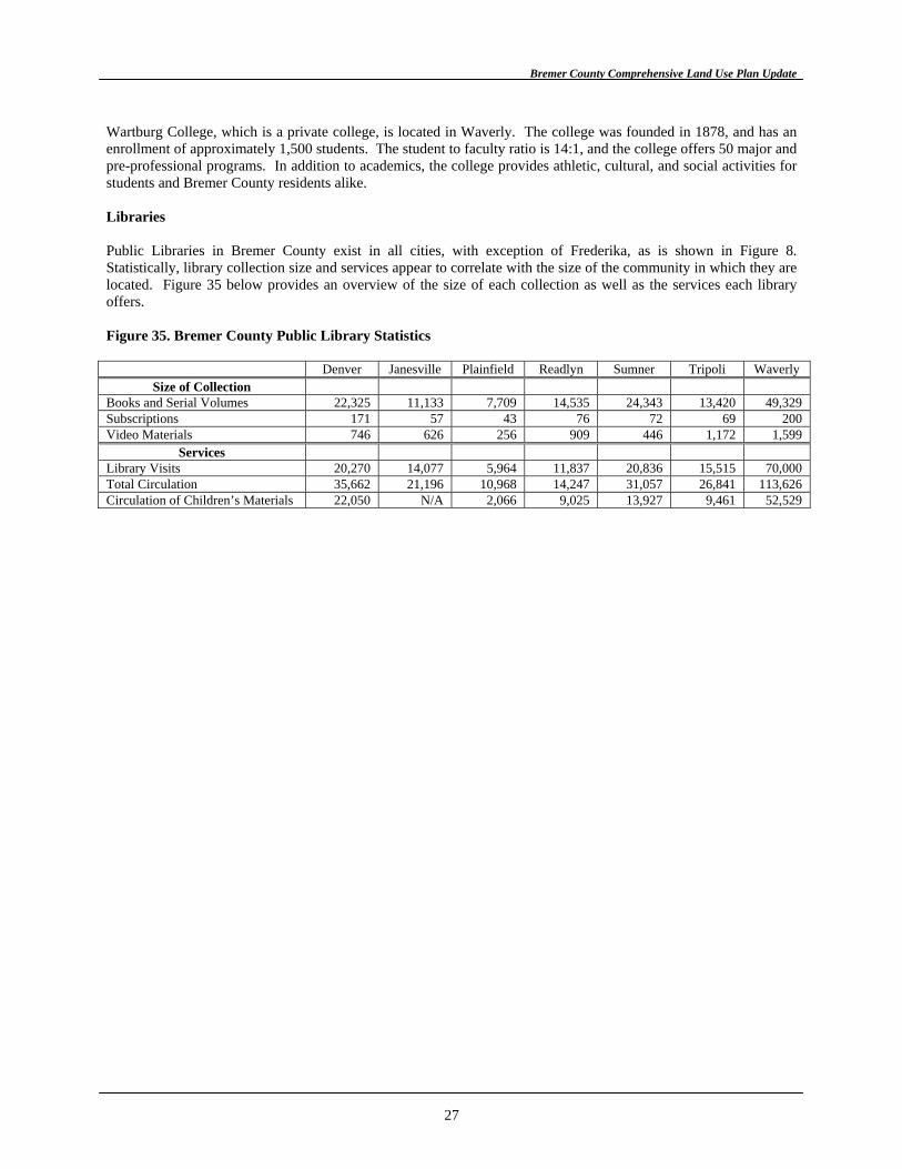
Bremer County Comprehensive Land Use Plan Update
Wartburg College, which is a private college, is located in Waverly. The college was founded in 1878, and has an enrollment of approximately 1,500 students. The student to faculty ratio is 14:1, and the college offers 50 major and pre-professional programs. In addition to academics, the college provides athletic, cultural, and social activities for students and Bremer County residents alike. Libraries Public Libraries in Bremer County exist in all cities, with exception of Frederika, as is shown in Figure 8. Statistically, library collection size and services appear to correlate with the size of the community in which they are located. Figure 35 below provides an overview of the size of each collection as well as the services each library offers. Figure 35. Bremer County Public Library Statistics
Denver Janesville Plainfield Readlyn Sumner Tripoli Waverly Size of Collection
Books and Serial Volumes 22,325 11,133 7,709 14,535 24,343 13,420 49,329 Subscriptions 171 57 43 76 72 69 200 Video Materials 746 626 256 909 446 1,172 1,599
Services Library Visits 20,270 14,077 5,964 11,837 20,836 15,515 70,000 Total Circulation 35,662 21,196 10,968 14,247 31,057 26,841 113,626 Circulation of Children’s Materials 22,050 N/A 2,066 9,025 13,927 9,461 52,529
27
���������������� �������������� ����� ����������������������������
��
����
����
��
��
����
��
���
��
�
�
�
�
�������
��
��
��� �
��
�����
���
������
����
����� ��
����
������
���������
� ����
������
����
����
������ ���
��������
�� ����
� ���� ���
� ��
� ��
� ���
� ���
� ���� ���
� ���
� ���
� ���
� ���
� ���
� ���
� ���
�����
����
��������
���
����
���
���
���
����
����
���
����
����
���
�����
���
����� ���
�����
���
���
����
���
���
������
����
����
���
���
���
���
���
���
����
����
��
��
�����
����
����
���
���
���
���
����
���
���
����
����
���
���
���
���
���
���
���
���
����
�����
���
���
���
����
���
���
������
��������
�����
����
������
� ���
���
��������
�����
������������ ����������
��������
����
�����
���
�����
�����
����
����
���������
������
�����
�!����!���
�� ���� ��
�������
����
������������
�����
���� ��
�� ����
������
�����
�������"��
"�����
����� ��������
������
��������
�� ��
������
�����
���
�����
�� ��
�������
����
�����
����
�����
�����
������
���� ��
�� ����
������ �����
�����
��# ���
�������"��
"�����
�������������
������
���
������
��������
�� ��
������
�����
����
�
������������� �����������������
��
������
���
����
�������
��
����
����
�����
����
���
���
������
����
��
����
������
����
�����
����
����
��
����
��
��
����
����
��
��
����
��
�������
��
��
��� �
��
�����
���
������
����
����� ��
����
�����
����
���
���������������
��������
����������
�������������������
����������������������
���������������������
�����������������
������������������� ����������
��������������
������
����������
�����
������
����
�������������
������
���������
� ����
������
����
����
������ ���
��������
�� ����
� ���� ���
� ��
� ��
� ���
� ���
� ���� ���
� ���
� ���
� ���
� ���
� ���
� ���
� ���
��������
���
����
���
���
���
����
����
���
����
����
���
�����
���
����� ���
���
���
����
���
���
������
����
����
���
���
���
���
���
���
����
����
��
��
����
����
���
���
���
���
����
���
���
����
����
���
���
���
���
���
���
���
���
����
���
���
���
����
���
���
������
��������
�����
����
������
� ���
���
��������
�����
������������ ����������
������
�����
�
�����
���
�����
�����
����
����
���������
������
�����
�!����!���
�� ���� ��
�������
����
������������
�����
���� ��
�� ����
������
�����
�������"�� "�����
����� ��������
������
��������
�� ��
������
�����
���
�����
�� ��
�������
����
�����
����
�����
�����
������
���� ��
�� ����
������ �����
�����
��# ���
�������"��
"�����
�����
��������
������
���
������
��������
������
�����
����
�����
�����
�����
�
������������������� ���� ���������������� �������������� ����� ����������������������������
��
�����
�
��
����
����
��
��
����
��
��
��
��
��
��
����
��
��
��
��
��
��
��
��
��
�
�
��
��
��
��
��
�� ��
��
�������
��
��
��� �
��
�����
���
������
����
����� ��
����
�����
����
������
���������
� ����
������
����
����
������ ���
����
������ ��
��
� ���� ���
� ��
� ��
� ���
� ���
� ���� ���
� ���
� ���
� ���
� ���
� ���
� ���
� ����
�
�
�
�
��
�
�
�
��
�� ��
��
��
��
��
����
��
���
��
�� ��
��
��������
���
����
���
���
���
����
����
���
����
����
���
���
����� ���
���
���
����
���
���
������
����
����
���
���
���
���
���
���
����
����
��
��
����
����
���
���
���
���
����
���
���
����
����
���
���
���
���
���
���
���
���
����
���
���
���
����
���
���
������
��������
�����
����
������
� ���
���
��������
�����
������������ ����������
������
�����
�
�����
���
�����
�����
����
����
���������
������
�����
�!����!���
�� ���� ��
�������
����
������������
�����
���� ��
�� ����
������
�����
�������"��
"�����
����� ��������
������
��������
�� ��
������
�����
���
�����
�� ��
�������
����
�����
����
�����
�����
������
���� ��
�� ����
������ �����
�����
��# ���
�������"��
"�����
�������������
������
���
������
��������
�� ��
������
�����
����
�����
�����
�����
�
������������� ���������������� ���������������� �������������� ����� ����������������������������
��
��
����
��
��� ��
��
�� �
��� ��� ��� ��� ��� ��� ��� ��� ��� ���
����
����
���� ���� � �� ��� �� �� �� �� ���� ��� ���� ���� ����
���
����
��� ��
����
����
���
����
���
�� ��
����
��
����
����
����
�����
������
������
�� ���
����
�����
������
�����
����
��
�����
������
�����
���
���
�����
������
�� ��
� ���
������
������
�����
����
�����
������
������
��
! !�"
#���
$��
���
������
�����
�����
���
������
������
�� �
%���
�����
������
&���
���
����
������
������
��
� ��
�'(
���%
����
� �#��
� ���
��
���"�
�����
���
�#�
�����
����
�����
���
�����
����
&��
���
����
���
�����
��� �
����
��� ��
��
�� �(
�����
�����
������
�����
� &�
���"�
%��
�����
�)
*%�
����
%��+
"�����
����
������
������
��
� ,
���
����
����
-��%
��
� ���
�
����
��
��
����
����
��
��
����
�� ��
��
��
��
��
��
����
�������
��
��
��� �
��
�����
���
������
����
����� ��
����
�����
����
��������
��
�
������
���������
� ����
������
����
����
������ ���
��������
�� ����
����������������
�� ������������
�����
���� ���������
��������
�� ������������
����
���������
�� ������������
���
�����������
��������
�� ������������
��
�����������
��������
�� ������������
��
������������
�� ������������
����
������
�����������
��� ������������
����
����������
��������
�� ������������
����
�����������
�� ������������
� ���� ���
� ��
� ��
� ���� ���
� ���� ���
� ���
� ���
� ���
� ���
� ���
� ���
� ���
��������
���
����
���
���
���
����
����
����
����
���
�����
���
����� ���
���
���
����
���
���
������
����
����
���
���
���
���
���
����
����
��
��
����
����
���
���
���
���
����
���
���
����
����
���
���
���
���
���
���
���
���
����
���
���
���
����
���
���
������
��������
�����
����
������
� ���
���
��������
�����
������������ ����������
������
�����
�
�����
���
�����
�����
����
���������
������
�����
�!����!���
�� ���� ��
�������
����
������������
�����
���� ��
�� ����
������
�����
�������"��
"�����
����� ��������
������
��������
�� ��
������
�����
���
�����
�� ��
�������
����
�����
����
�����
�����
������
���� ��
�� ����
������ �����
�����
��# ���
�������"��
"�����
�������������
������
���
������
��������
������
�����
����
�����
�����
�����
�
����� �� ��������� ��� ������� �������� ���������������� �������������� ����� ����������������������������
��
�����
���
��������
Bremer County Comprehensive Land Use Plan Update
PUBLIC UTILITIES Water Water service in Bremer County is typically provided by private, individual or common wells. The wells tap rechargeable groundwater aquifers for water. In terms of need, the County does not foresee the need for a common or public water system. However, the County does want to protect the groundwater from depletion or contamination in order to maintain its supply of potable water. On-Site Septic Systems The primary means of disposing of sewage in the County is by individual, on-site septic systems. These on-site systems include tanks and septic fields for disposal of household sewage. As with water service, the County does not envision the need for a common public sewage system. The County, however, does regulate on-site systems through ordinances, inspections and its Board of Health. Electricity, Natural Gas, Telephone Electric Service Electric service is provided to Bremer County by nine different providers including: MidAmerican Energy Company; Butler County Rural Electric Cooperative; Interstate Power Company; Allamakee-Clayton Electric Cooperative; East-Central Rural Electric Cooperative; and county providers in Denver, Readlyn, Sumner, and Waverly. Solid Waste The County established a solid waste sanitary landfill in August of 1971. The landfill, which is located approximately eight miles northeast of Waverly, is open to all persons and businesses within Bremer County. Out-of-county solid waste is not accepted by the landfill. All cities contract with Bremer County for use of the landfill. Residents of the cities of Waverly and Sumner have their solid waste collected and transported to the landfill by city-owned equipment and employees. Solid waste is collected and transported to the landfill by a private contractor, Waste Management, Incorporated in the cities of Denver, Janesville, and Plainfield. The Tripoli-Readlyn Sanitation Agency collects and transports solid waste from these communities to the landfill. In the city of Frederika, Jim Buehler Waste Disposal, Incorporated provides the solid waste collection and transportation services. Bremer County is recycling at a rate of 45 percent through drop-off sites in all of the cities as well as with curbside collection in Waverly. Household chemicals are accepted and properly disposed of at the Bremer County Regional Collection Center, which is located at the landfill. The Regional Collection Center is operated as a free service for Bremer County residents. As for future needs, the life expectancy of the landfill is projected to be approximately 15 to 20 years, depending on the continued success of the recycling programs. In addition, it is anticipated that once the landfill reaches its capacity, a transfer station will be utilized to transport solid waste out of the County. Flood Control Bremer County began regulating floodplain activity and development in July of 1980, at which time the County became a participant in the emergency program of the National Flood Insurance Program (NFIP). In July of 1990, the county applied for, and was accepted, in the regular program of the NFIP. The County continues to make efforts to discourage further development in the flood-prone areas of the County, as are shown in Figure 9. In addition, floodplain protection and mitigation efforts include the voluntary acquisition of flood-prone properties following the floods of 1999.
32
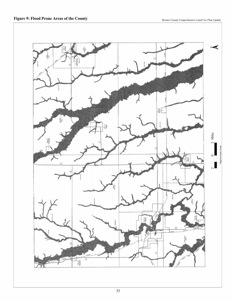
��
��
�����
�
���������������� �������������� ����� ������������������������������������������� ���������������� ��
�
����
�����
���
��
Bremer County Comprehensive Land Use Plan Update
CIRCULATION AND TRANSPORTATION The following section describes the transportation network in Bremer County. Note that because transportation has a profound influence on land use, and vice versa, this section is important in developing a future land use plan for the County. Roads/Streets Bremer County has an elaborate system of roads and streets, most of which were designed using the Rectangular Land Survey System. U.S. Highways 63 and 218 traverse the County north and south. Bremer County also has access to Iowa Highways 3, 93, and 188. As for secondary roads, many of which are paved and provide access to most areas of the County. Figure 10 shows the highway and road network in Bremer County. Air Air service to Bremer County residents is available on a limited basis at the Waverly Airport, which is shown on Figure 10. The closest commercial air service is available in Waterloo and Cedar Rapids. Rail Rail service in Bremer County, as is shown in Figure 10, is available on a limited basis. The Chicago, Rock Island and Pacific Railroad serves the southwestern part of the County, while the Chicago and Northwestern Railroad serves the northeastern part of Bremer County. The Illinois Central Railroad, which follows U.S. Highway 218, offers the most comprehensive rail service to businesses in the County. Transit The Iowa Northland Regional Transit Commission (RTC) offers limited transit service to residents of Bremer County. Currently, demand response service, which requires 24-hour notice, is offered in Waverly. The remainder of the County is served by RTC on a case-by-case basis depending on space and service timing considerations. Water Water transportation is not available in Bremer County, with the exception of private recreational boating. As was previously indicated, the County is influenced by the Cedar, Wapsipinicon, and Shell Rock Rivers, which are illustrated in Figure 10. At this time, it is unlikely that these rivers will be used as a means of transportation without efforts to remove silt and sediment through dredging operations. In addition to dredging, damming of the river may be necessary to increase water depths to acceptable levels. Finally, in terms of environmental protection, efforts will have to be made to protect wildlife from chemicals and pollution that can be concentrated in Iowa waterways. Bike/Pedestrian Access to bike and pedestrian trails for transportation is becoming more prevalent in Bremer County. Currently, most trials, as shown in Figure 11, begin and/or end in Waverly. The longest trail segment in the County is between Waverly and Denver, which is approximately 7 miles. In addition, efforts are being made to plan and extend recreational trails throughout Bremer County. Figure 11 shows planned trail development in County.
34
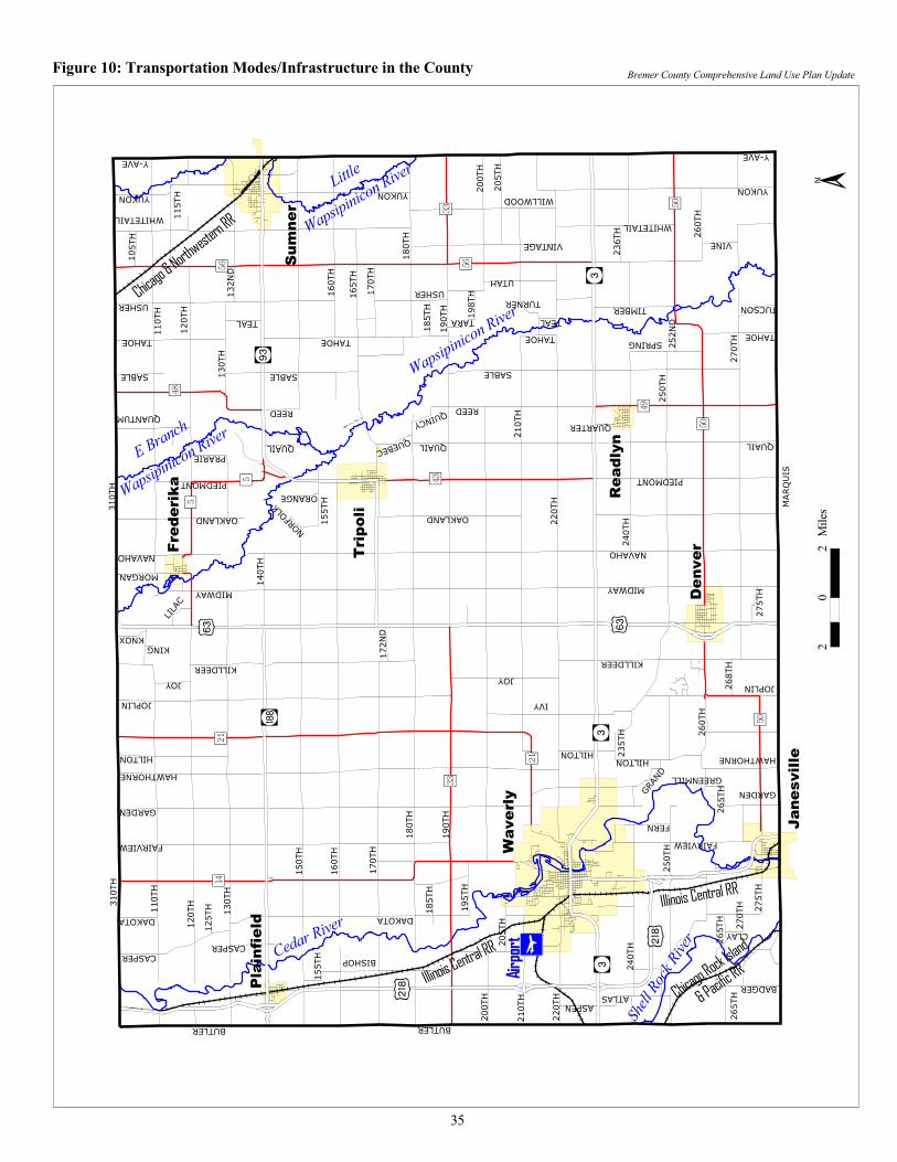
��
����
����
��
��
����
��
����
�����
��
��
��� �
��
�����
���
������
����
����� ��
����
����������������
�
�����������������
� ��������
���������
������������
����������
�
�����
� �������
�
������ �
�����
� �������
�
������
�����
� �������
�
� ��������
�� ���
�����
�����
����
�������
� �������
� ���� ���
� ��
� ��
� ���
� ���
� ���� ���
� ���
� ���
� ���
� ���
� ���
� ���
� ���
������
�
�����
�����
���
��
� ���
� ���
� ���
�����
� ���
� ���
� ���
���������
�����
�����
�����
�����
�����
�� ��
�����
�����
�����
�����
�����
�����
�����
�����
�����
�����
�����
�����
�����
�����
�����
�����
�����
� ���
�����
�����
�����
�����
� ���
� ���
�����
�����
�����
�����
�����
�����
�����
�����
�����
�����
�����
�����
����
�������
��������
�����
����
������
������
���
���������
���
�������� ������
������
�����
�
�����
���
�����
������
����
����
����������
������
����
�!����!���
� ��� ��
���������
����
���������������
�����
��������
�� ����
������
������
�������"��
"�����
������ ���������
������
��������
�� ���
������
�����
����
�����
� ��
���������
����
����
�����
�����
����
������
��������
�� ����
������������
������
��# ���
�������"��
"�����
���������������
������
�����
������
��������
�� ���
������
�����
�����
�����
�����
�����
��������������������������������������������������������������������������������������� �������������� ������ ����������������������
��
�����
��
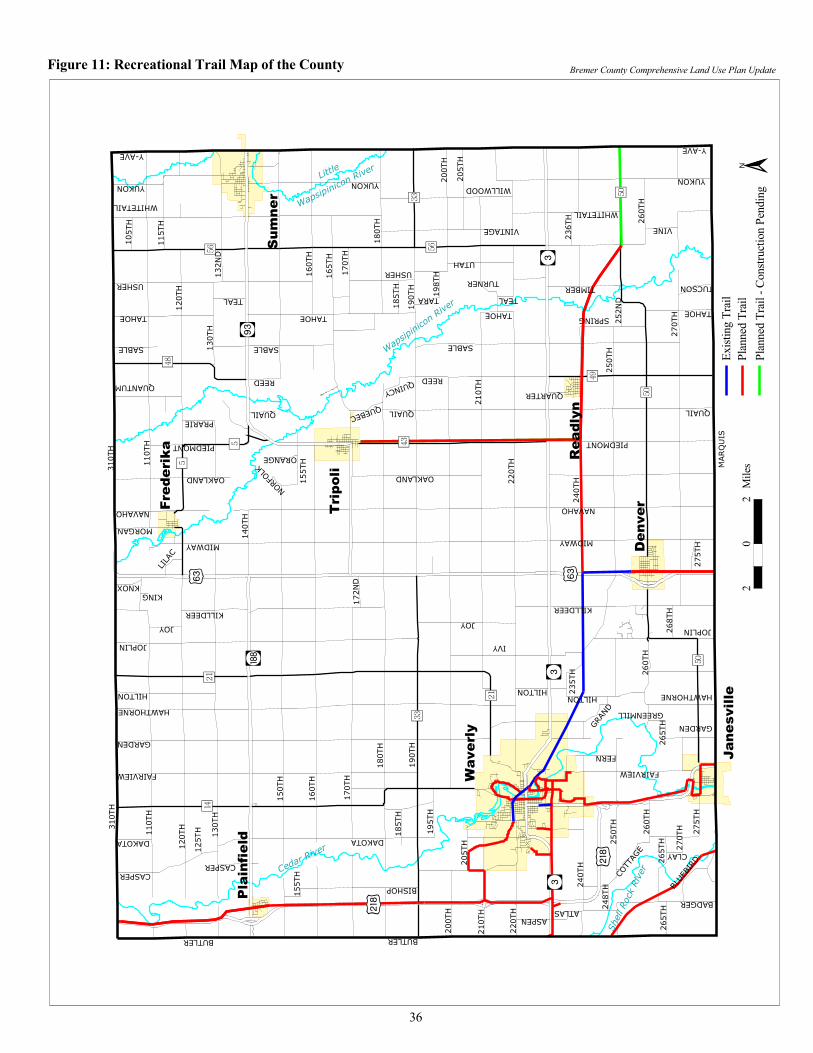
��
����
����
��
��
����
��
�������
��
��
��� �
��
�����
���
������
����
����� ��
����
�����
����
������
���������
� ����
������
����
����
������ ���
��������
�� ����
� ���� ���
� ��
� ��
� ���
� ���
� ���� ���
� ���
� ���
� ���
� ���
� ���
� ���
� ���
��������
���
����
���
���
���
����
����
���
����
����
���
�����
���
����� ���
���
���
����
���
���
������
����
����
���
���
���
���
���
���
����
����
��
��
����
����
���
���
���
���
����
���
���
����
����
���
���
���
���
���
���
���
���
����
���
���
���
����
���
���
������
��������
�����
����
������
� ���
���
��������
�����
������������ ����������
������
�����
�
�����
���
�����
�����
����
����
���������
������
�����
�!����!���
�� ���� ��
�������
����
������������
�����
���� ��
�� ����
������
�����
�������"�� "�����
����� ��������
������
��������
�� ��
������
�����
���
�����
�� ��
�������
����
�����
����
�����
�����
������
���� ��
�� ����
������ �����
�����
��# ���
�������"��
"�����
�������������
������
���
������
��������
�� ��
������
�����
����
�����
�����
�����
��
�����
�
���������������� �������������� ����� ��������������������������������������������� �������������� ������� ����
�
�����
�����
����
����
�����
����
����
�����
������
�����
�����
�����
��
Bremer County Comprehensive Land Use Plan Update
RECENT PLANNING EFFORTS Hazard Mitigation Plan The Bremer County Hazard Mitigation Plan was developed to assess the ongoing mitigation goals in the community; to evaluate mitigation alternatives that should be undertaken; and to outline a strategy for implementing the Plan. Within the Plan, the County hopes to build a disaster-resistant community and take action to protect families, businesses, and public facilities by reducing the effects of natural disasters. The Bremer County Hazard Mitigation Plan was formulated by elected officials, staff, agency representatives, business owners and operators, and interested citizens. Extraterritorial Agreement with Waverly In December of 1998, Bremer County and the city of Waverly signed an intergovernmental agreement that defined development standards in the unincorporated area around Waverly. Specifically, the jurisdictions signed a legal agreement, authorized under Chapters 28E and 354 of the Iowa Code, government land development in a two-mile radius around the city of Waverly. The Agreement involved numerous planning sessions with an ad hoc committee as well as county and city elected officials, planning commissions, and staff members. In addition, the Agreement utilizes both jurisdiction’s subdivision ordinances and building codes as implementation tools. It should be noted that the Agreement, which included a five-year termination clause, expires in December 2003 unless reauthorized by both the County and City.
37
Bremer County Comprehensive Land Use Plan Update
IMPLEMENTATION OF THE PLAN
This Section of the Plan defines the land use goals and their corresponding objectives for Bremer County. In terms of definitions, goals are generalized, optimistic statements of a desired end that should also be attainable and provide direction for forming specific objectives. Under each of the goals, the County has defined objectives that are specific to each goal. These objectives are not meant to replace the goals, but rather they should provide implementation guidance for the Board of Supervisors, Planning and Zoning Commission, Board of Adjustment, and staff when interpreting the Plan. In addition, objectives typically address more specific concerns of a county and are more procedural in nature than goals. The following section defines the Bremer County land use goals and their corresponding objectives. Land Use Goals and Objectives 1. It is a goal of Bremer County to strive to preserve agricultural land, placing emphasis on areas that are
considered “prime” agricultural areas. a. In making land use decisions, Bremer County shall consider the compatibility of existing surrounding
land uses and the proposed use. b. Bremer County shall consider the availability of services needed for land use change requests. c. The County will require applicants to provide information regarding the services required for
development at the time of the development request. d. Bremer County will prioritize the preservation of “prime” agricultural soils, which includes soil types
with a Corn Suitability Rating (CSR) of fifty (50) or greater. e. The County shall utilize large minimum lot size requirements (35 acres) as a means of discouraging
development in the unincorporated areas. f. Bremer County will investigate utilization of factors in addition to CSR and lot size when making land
use decisions (i.e. Land Evaluation and Site Assessment).
2. It is the goal of Bremer County to preserve and protect environmental features and sensitive areas such as floodplains, wetlands, woodlands, and other sensitive areas.
a. The County shall protect natural features including surface waters including the Cedar River and Wapsipinicon River and their impacts on other jurisdictions.
b. Bremer County shall consider topography when making land use decisions. c. In addition, Bremer County shall protect or maintain the quality of its air and groundwater resources. d. As is required, the County shall implement federal, state, county policies and ordinances designed to
protect its natural environment and environmentally sensitive areas.
3. It is the goal of Bremer County to consider the need for services when assessing a potential development. a. The County will require that necessary services shall be provided concurrent with development. For
the purposes of this Plan, “necessary services” shall include: i. Access to a transportation network through highways, roads, streets, and driveways.
ii. Access to a potable, approved water supply (individual well and/or shared wells). The County will encourage use of shared or central wells, when possible.
iii. Access to an approved on-site septic system or connection to a central sewer system. iv. Access to public safety services (sheriff, fire, ambulance services). v. Connections to other utilities (electric, gas, etc.).
vi. Access to educational opportunities.
4. It is the goal of Bremer County to maintain, and improve when possible, the quality of living of its residents. Quality of life, under this Plan, shall include the following factors:
a. Education. The County will work to ensure that all Bremer County residents have access to a quality educational system.
b. Transportation. Bremer County will maintain and continue to develop a multi-modal transportation network that includes access to highways, roads, air service, transit service, and trail infrastructure.
c. Crime. The County will continue to prevent and minimize criminal activity.
38
Bremer County Comprehensive Land Use Plan Update
d. Arts, Culture, Library, and Historical opportunities. The County will work with appropriate organizations to offer cultural opportunities to its residents.
e. Parks and Recreation opportunities. Bremer County, specifically the County Conservation Board, will work with the incorporated communities in the County to offer access to golf courses, recreational trails, swimming pools, boating and fishing, open space, and community celebrations and festivals.
5. It is the goal of Bremer County to limit residential development in the County to areas that are planned for this
type of growth. a. The County shall protect, as best it can, agricultural soils with Corn Suitability Rating (CSR) of fifty
(50) or more from residential development. b. The County shall encourage infill development to occur in existing subdivisions where infrastructure
may be more readily available. c. As is possible, Bremer County shall work to direct new residential growth to occur in incorporated
communities where services are more readily available. d. The County, in considering residential development, shall be cognizant of adjacent land use(s) and
attempt to minimize any associated conflicts or concerns. 6. It is the goal of Bremer County to only allow limited commercial development in the unincorporated areas of
the County. a. The County shall protect, as best it can, agricultural soils with Corn Suitability Rating (CSR) of fifty
(50) or more from commercial development. b. As is possible, Bremer County shall work to direct new commercial growth to occur in incorporated
communities where services are more readily available. If this is not possible, the County shall attempt to direct commercial growth to areas where services may be available or to areas where minimal impact to agriculture will occur.
c. The County, in considering commercial development, shall be cognizant of adjacent land use(s) and attempt to minimize any associated conflicts or concerns.
7. It is the goal of Bremer County to only allow limited industrial development in the unincorporated areas of the
County a. The County shall protect, as best it can, agricultural soils with Corn Suitability Rating (CSR) of fifty
(50) or more from industrial development. b. As is possible, Bremer County shall work to direct new industrial growth to occur in incorporated
communities where services are more readily available. If this is not possible, the County shall attempt to direct industrial growth to areas where services may be available or to areas where minimal impact to agriculture will occur.
c. The County, in considering industrial development, shall be cognizant of adjacent land use(s) and attempt to minimize any associated conflicts or concerns.
8. It is the goal of Bremer County to collaborate with other levels of government with regard to future land use and
development. Specifically, the County shall collaborate with the federal, state, city, and school districts as is appropriate and/or possible. The County may also choose to work collaboratively with other counties.
9. It is the goal of Bremer County to adopt and amend, when appropriate, a Comprehensive Land Use Plan. The
purpose for the Plan is the following. a. The Plan will serve as a guide and a statement of policies for the County b. The Plan will seek to promote orderly growth. More specifically, the Plan will attempt to:
i. Prevent leapfrog development ii. Include a severance policy that requires that land that is severed from a city is reverted back to
agricultural use and corresponding zoning. iii. Provide guidance to the various County commissions, boards, and authorities (P&Z, Board of
Adjustment, Board of Health) that may be involved in county land use management. iv. Guide County staff as development is reviewed and considered.
c. The Plan is intended to be the planning and legal foundation for: i. The County Zoning Ordinance.
ii. The County Subdivision Ordinance.
39
Bremer County Comprehensive Land Use Plan Update
iii. The County Building Code (including building, mechanical, plumbing, and electrical codes). iv. Any future County Urban Renewal Plans or Ordinances.
d. The Plan, and its implementation tools listed in 9(c) above, is designed to encourage citizen or community input through defined and statutory development, amendment, and implementation processes.
e. The County will require or measure the following checklist of issues prior to development approval. i. Consistency with the Plan, including the Future Land Use Map.
ii. Compatibility with surrounding land use(s). iii. Minimal impact on adjacent property. iv. Appropriate density of proposed use and its surrounding. v. Minimal impact on traffic generation and flow.
vi. The ability of the proposal to obtain or access adequate services. vii. Minimal environmental impact.
viii. Other factors affecting general intent and purpose of Plan. f. The Plan, which is intended to be broad and general, will serve as an umbrella for other County plans
such as the Hazard Mitigation, Community Builder Plan, and Housing Needs Assessment.
10. It is the goal of Bremer County, and its residents, to recognize that land use planning is a continuous process. a. The County will review this Plan as the need arises. b. This Plan will be implemented through various departments, policies, and ordinance including, but not
limited to, the following. i. County staff
ii. County ordinances iii. County plans iv. County Budget v. Outside agencies
40
Bremer County Comprehensive Land Use Plan Update
Future Growth and Development Land use in Bremer County, as in most Iowa counties, is and will be dominated by agriculture. The rich, fertile soils easily support crop production and animal husbandry activities. There are, however, areas of proposed residential, commercial, and recreational development in the unincorporated areas of the County. The following text, together with Figure 12, will outline the future land use development plan for the County Agricultural Uses. As was previously stated, agriculture is the predominate land use in the unincorporated areas of the County, and it is anticipated to remain so in the future. Figure 3, which shows Corn Suitability Ratings (CSR) of Bremer County soils, coupled together with the previously stated Land Use Goals and Objectives, comprise the basis of the County’s efforts to preserve its prime agricultural soils and areas as are shown in Figure 12. In terms of uses, it is anticipated that the primary agricultural uses will include: crop production; animal husbandry; pastureland; reserve areas; woodlands preservation; and wetlands protection. Residential Uses. Residential uses are projected to occur in areas delineated as such in Figure 12. These areas include residential subdivisions that are located throughout the County, most of which, excluding Denver Hills and areas north of Waverly, are very small areas that exist today. The primary type of residential use is anticipated to be single-family dwelling units. Utility services will likely be provided by septic systems and individual or shared wells. Commercial and Industrial Uses. Commercial and industrial uses in Bremer County are planned to occur in correspondingly labeled areas shown in Figure 12. In general, these uses will occur sporadically throughout the County and will be comprised of service industries, agriculturally related businesses, and other light industries. Utility services for these businesses will either be provided by individual septic systems, wells, and/or through nearby incorporated communities. Public or Open Space. Areas included in this category include parks, recreational and wildlife areas, public access areas, and greenbelt along the Wapsipinicon River. This Plan intends to preserve and protect these areas from encroachment.
41
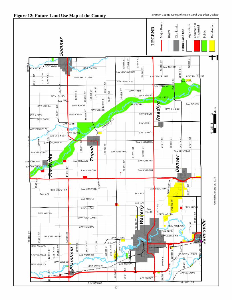
HILTONAVE
WILDWOOD AVE
IVORY AVE
ELK AVE
195T
H ST
QUANTUM AVE24
8TH
STCOTTA
GE AVE
238T
H ST
PRAIRIE AVE
235T
H ST
178T
H ST
MARQ
UIS
RD
142R
D ST
190T
H ST
VIKING AVE
220T
H ST
MIDWAY AVE
180T
H ST
160T
H ST
150T
H ST
110T
H ST
210T
H ST
120T
H ST
130T
H ST
BUTLER AVE
270T
H ST
310T
H ST
GARDEN AVE
260T
H ST
HAWTHORN AVE
170T
H ST
PIEDMONT AVE
JOPLIN AVE
EASTON AVE
FAIRVIEW AVE
165T
H ST
YUKON AVE
252N
D ST
USHER AVE
IVY AVE
250T
H ST
275T
H ST
200T
H ST
132N
D ST
RENO AVE
VINTAGE AVE
240T
H ST
BISHOP AVE
KILLDEER AVE
IVAN
HOE
ST
TAHOE AVE
BUTLER RD
212T
H ST
205T
H ST
CASPER AVE
OAKLAND AVE
EUCLID AVE
BADGER AVE
NAVAHO AVE
115T
H ST
TMBER DR
265T
H ST
WHITETAIL AVE
UTAH AVE
IVORY AVE
155T
H ST
SPRING AVE
195T
H ST
ASPEN AVE
FERN AVE
SABLE AVE
QUAIL AVE
108T
H ST
TEAL AVE
140T
H ST
105T
H ST
VINE AVE
185T
H ST
268T
H ST
SIERRA AVE
215T
H ST
MORGAN AVE
172N
D ST
DAKOTA AVE
198T
H ST
QUINCY AVE
125T
H ST
HILTON AVE
GARDEN AVE
250T
H ST
SABLE AVE
OAKLAND AVE
USHER AVE
YUKON AVE
150T
H ST
120T
H ST
160T
H ST
180T
H ST
PIEDMONT AVE
JOY AVE
SABLE AVE
YUMA AVE
240T
H ST
170T
H ST
270T
H ST
220T
H ST
120T
H ST
CASPER AVE
240T
H ST
QUAIL AVE
200T
H ST
NAVAHO AVE
185T
H ST
REED AVE
CASPER AVE
120T
H ST
310T
H ST
WHITETAIL AVE
TAHOE AVE
160T
H ST
OAKLAND AVE
310T
H ST
205T
H ST
FAIRVIEW AVE
JOY AVE
KILLDEER AVE
270T
H ST
180T
H ST
TAHOE AVE
KILLDEER AVE
DAKOTA AVE
260T
H ST
DAKOTA AVE
260T
H ST
YUKON AVE
130T
H ST
200T
H ST
250T
H ST
110T
H ST
HILTON AVE
TAHOE AVE
WHITETAIL AVE
REED AVE
NAVAHO AVE
MIDWAY AVE
Waver
ly
Sumner
DenverTri
poli
Janesv
ille
Freder
ika
Readly
n
Plainfi
eld
±0
12
0.5
Mile
s
Figure 12: Future Land Use Map of the County Bremer County Comprehensive Land Use Plan Update
Amen
ded
Janu
ary
25, 2
010
42
L
EG
EN
D
Maj
or R
oads
Rive
rs
City
Lim
its
Futu
re L
and
Use
Agr
icul
ture
Publ
ic
Resid
entia
l
Com
mer
cial
/ Ind
ustri
al
Bremer County Comprehensive Land Use Plan Update
AMENDMENT OF THE PLAN The Bremer County Board of Supervisors may, from time-to-time, want to amend this Plan, including any and/or all maps and illustrations. In order to do so, first the County Planning and Zoning Commission shall consider the proposed amendment and conduct a properly noticed public hearing. The Planning and Zoning Commission shall make a recommendation on the proposed amendment, after the public hearing, and send it to the Board of Supervisors for consideration. The Planning and Zoning Commission is free to make further suggestions pertaining to the proposed amendment to the Board of Supervisors. After receiving recommendation from the Planning and Zoning Commission, the Board of Supervisors shall also hold a properly noticed public hearing on the proposed amendment. After their public hearing, the Board is free to make the final decision, including alterations to the amendment, prior to adoption of any amendment. The Board of Supervisors shall adopt amendments to this Plan by resolution after a simple majority vote of the Board.
43