Water Year 2005 Season Wrap up
15
Water Year 2005 Water Year 2005 Season Wrap up Season Wrap up Wind River – Big Horn River Basin Wind River – Big Horn River Basin Advisory Group Meeting Advisory Group Meeting December 6, 2005 December 6, 2005 Cody, Wyoming Cody, Wyoming
description
Water Year 2005 Season Wrap up. Wind River – Big Horn River Basin Advisory Group Meeting December 6, 2005 Cody, Wyoming. Reservoir Carry-Over Volumes October 1, 2004 Bull Lake: 88,940 acre-feet 59% Pilot Butte: 15,630 acre-feet 45% Boysen: 475,100 acre-feet 63% - PowerPoint PPT Presentation
Transcript of Water Year 2005 Season Wrap up
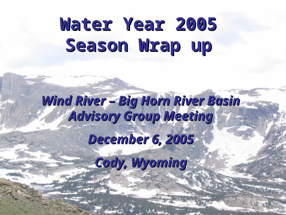
Water Year 2005Water Year 2005Season Wrap upSeason Wrap up
Wind River – Big Horn River Basin Wind River – Big Horn River Basin Advisory Group MeetingAdvisory Group Meeting
December 6, 2005December 6, 2005
Cody, WyomingCody, Wyoming
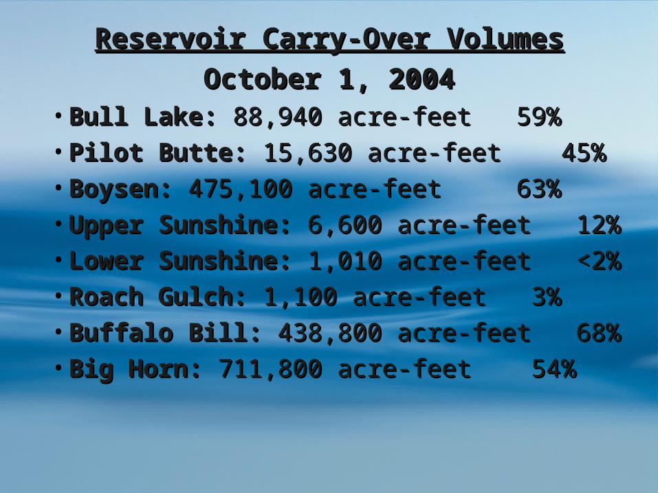
Reservoir Carry-Over VolumesReservoir Carry-Over Volumes
October 1, 2004October 1, 2004• Bull Lake:Bull Lake: 88,940 acre-feet 59% 88,940 acre-feet 59%
• Pilot Butte:Pilot Butte: 15,630 acre-feet 45% 15,630 acre-feet 45%
• Boysen:Boysen: 475,100 acre-feet 63% 475,100 acre-feet 63%
• Upper Sunshine: Upper Sunshine: 6,600 acre-feet 12%6,600 acre-feet 12%
• Lower Sunshine: Lower Sunshine: 1,010 acre-feet <2%1,010 acre-feet <2%
• Roach Gulch: Roach Gulch: 1,100 acre-feet 3% 1,100 acre-feet 3%
• Buffalo Bill: Buffalo Bill: 438,800 acre-feet 68%438,800 acre-feet 68%
• Big Horn: Big Horn: 711,800 acre-feet 54%711,800 acre-feet 54%

Streamflow ForecastsStreamflow Forecasts
DrainageDrainage April 1April 1 May 1May 1 June 1June 1
Clark’s Fork Riv,Clark’s Fork Riv, 65%65% 68%68% 55%55%Shoshone abv. Buffalo Shoshone abv. Buffalo BillBill
61%61% 62%62% 74%74%
Yellowtail InflowYellowtail Inflow 72%72% 73%73% 90%90%
Greybull RiverGreybull River 55%55% 65%65% 77%77%Wind River abv.Wind River abv.
BoysenBoysen82%82% 85%85% 85%85%
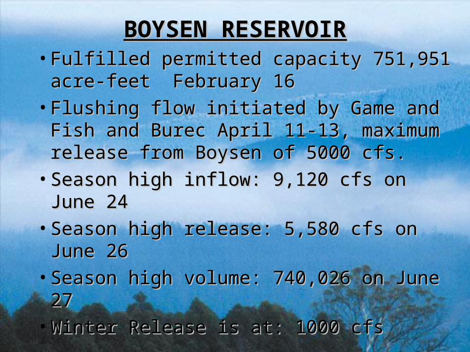
BOYSEN RESERVOIRBOYSEN RESERVOIR• Fulfilled permitted capacity 751,951 acre-Fulfilled permitted capacity 751,951 acre-
feet February 16 feet February 16
• Flushing flow initiated by Game and Fish Flushing flow initiated by Game and Fish and Burec April 11-13, maximum release and Burec April 11-13, maximum release from Boysen of 5000 cfs.from Boysen of 5000 cfs.
• Season high inflow: 9,120 cfs on June 24Season high inflow: 9,120 cfs on June 24
• Season high release: 5,580 cfs on June 26Season high release: 5,580 cfs on June 26
• Season high volume: 740,026 on June 27Season high volume: 740,026 on June 27
• Winter Release is at: 1000 cfsWinter Release is at: 1000 cfs

BULL LAKE RESERVOIRBULL LAKE RESERVOIR
•Fulfilled permit capacity on June 9, Fulfilled permit capacity on June 9, 151,951 acre-feet151,951 acre-feet
•Season high inflow: 1,970 cfs on June 21 Season high inflow: 1,970 cfs on June 21
•Season high outflow: 1900 cfs on June 22Season high outflow: 1900 cfs on June 22
•Winter Release is at: 25 cfsWinter Release is at: 25 cfs

BUFFALO BILLBUFFALO BILL• Fulfilled permitted capacity on Fulfilled permitted capacity on
May 24May 24
• Maximum volume stored: 634,738 Maximum volume stored: 634,738 acre-feet June 24acre-feet June 24
• Maximum inflow 8402 cfs May 21Maximum inflow 8402 cfs May 21
• Maximum release 5926 cfs June 26Maximum release 5926 cfs June 26
• Winter Release is at: 200 cfsWinter Release is at: 200 cfs
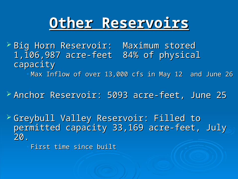
Other ReservoirsOther Reservoirs Big Horn Reservoir: Maximum stored Big Horn Reservoir: Maximum stored
1,106,987 acre-feet 84% of physical capacity1,106,987 acre-feet 84% of physical capacity• Max Inflow of over 13,000 cfs in May 12 and June 26Max Inflow of over 13,000 cfs in May 12 and June 26
Anchor Reservoir: 5093 acre-feet, June 25 Anchor Reservoir: 5093 acre-feet, June 25
Greybull Valley Reservoir: Filled to permitted Greybull Valley Reservoir: Filled to permitted capacity 33,169 acre-feet, July 20. capacity 33,169 acre-feet, July 20.
• First time since builtFirst time since built
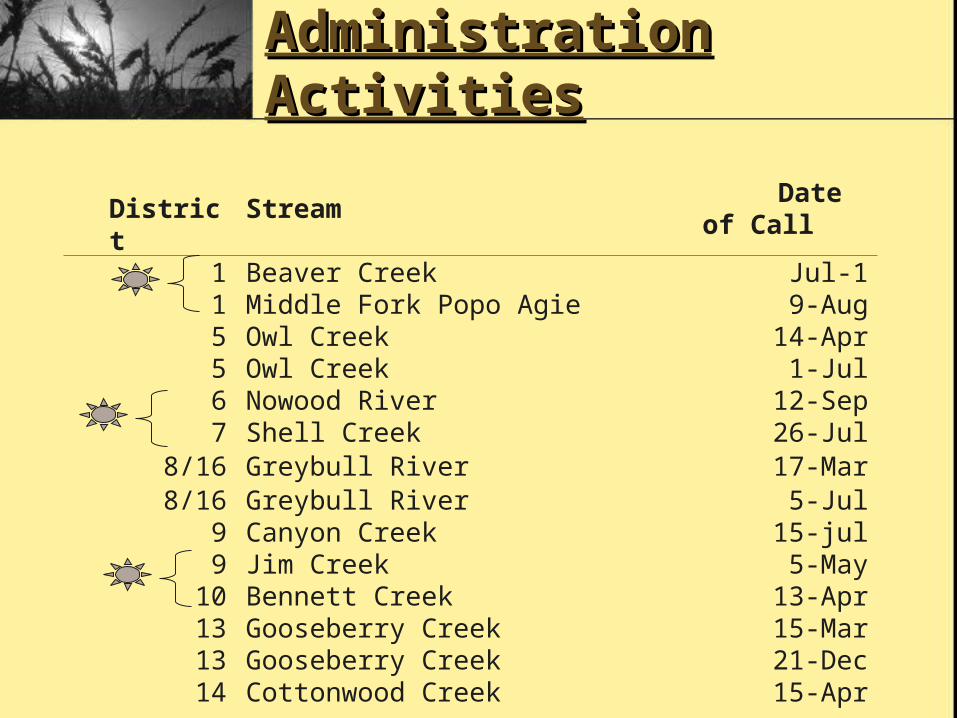
Administration Administration ActivitiesActivities
District Stream Date of Call1 Beaver Creek Jul-11 Middle Fork Popo Agie 9-Aug5 Owl Creek 14-Apr5 Owl Creek 1-Jul6 Nowood River 12-Sep7 Shell Creek 26-Jul
8/16 Greybull River 17-Mar8/16 Greybull River 5-Jul
9 Canyon Creek 15-jul9 Jim Creek 5-May
10 Bennett Creek 13-Apr13 Gooseberry Creek 15-Mar13 Gooseberry Creek 21-Dec14 Cottonwood Creek 15-Apr

Dividing the WatersDividing the Waters
Historical useHistorical use 4.074.07 5.275.27 4.574.57
Last year 2004Last year 2004 4.064.06 4.634.63 4.364.36
PeriodPeriod RVIDRVID LCIDLCID MVIDMVID
This year 2005This year 2005 4.154.15 4.884.88 4.854.85
Accounting began July 24Accounting began July 24thth
Successful RotationSuccessful Rotation RVID and MID entered agreement to rotate 15 cfs RVID and MID entered agreement to rotate 15 cfs during August for 15 days per turn.during August for 15 days per turn.

Other ActivitiesOther Activities• Greybull River Leveling ProgramGreybull River Leveling Program
– System works wellSystem works well– No major problems this seasonNo major problems this season– Thunderstorms still the wildcardThunderstorms still the wildcard
• General Adjudication: Large projects in process now.General Adjudication: Large projects in process now.
•Elk/Lovell CanalElk/Lovell Canal•Lake View Lake View CanalCanal•Deaver CanalDeaver Canal
•Cody CanalCody Canal•Big Horn Big Horn CanalCanal•Sidon CanalSidon Canal

Other Division ActivitiesOther Division Activities
• Stream gaging upgradesStream gaging upgrades
– Real-time data should be available on the Real-time data should be available on the Big Horn River next season on 8 Big Horn River next season on 8 additional canalsadditional canals
• 11 sites necessary to complete this task11 sites necessary to complete this task
– Four more are proposed for late 2006Four more are proposed for late 2006
– Middle Fork Popo Agie Equipment Middle Fork Popo Agie Equipment upgrade with NWSupgrade with NWS

• October 1, 2005October 1, 2005– Bull Lake: 66,100 acre-feet 44%Bull Lake: 66,100 acre-feet 44%– Pilot Butte: 12,300 acre-feet 35%Pilot Butte: 12,300 acre-feet 35%– Boysen: 591,900 acre-feet 78%Boysen: 591,900 acre-feet 78%– Upper Sunshine: 24,000 acre-feet 45%Upper Sunshine: 24,000 acre-feet 45%– Lower Sunshine: 21,000 acre-feet 36%Lower Sunshine: 21,000 acre-feet 36%– Roach Gulch: 8,000 acre-feet 24% Roach Gulch: 8,000 acre-feet 24% – Buffalo Bill: 450,300 acre-feet 70%Buffalo Bill: 450,300 acre-feet 70%– Big Horn: 1,000,506 acre-feet 76%Big Horn: 1,000,506 acre-feet 76%
Future OutlookFuture Outlook
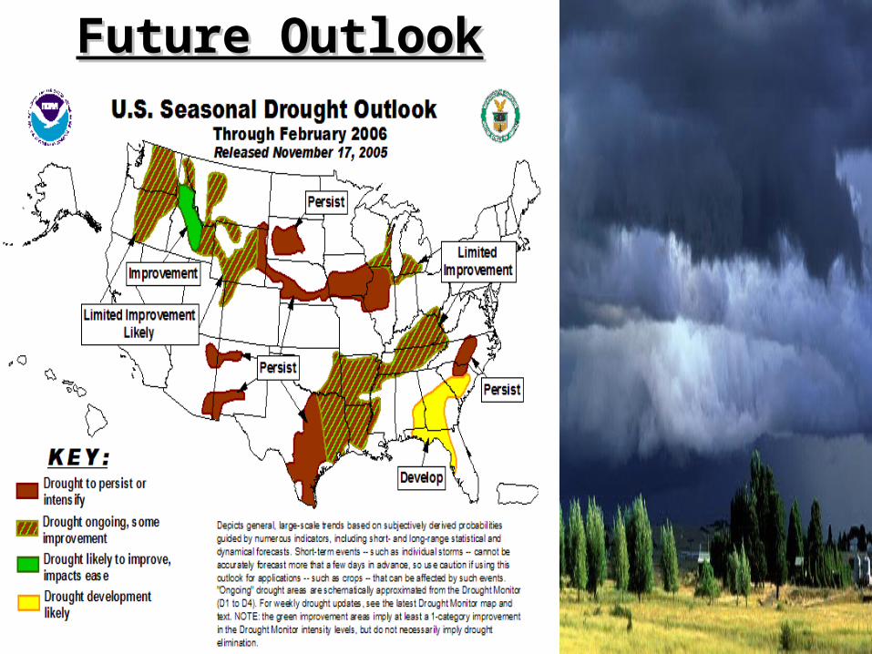
Future OutlookFuture Outlook


Questions?