Water Resource Management Brian T. Coffey and ......Brian T. Coffey and Associates Limited...
28
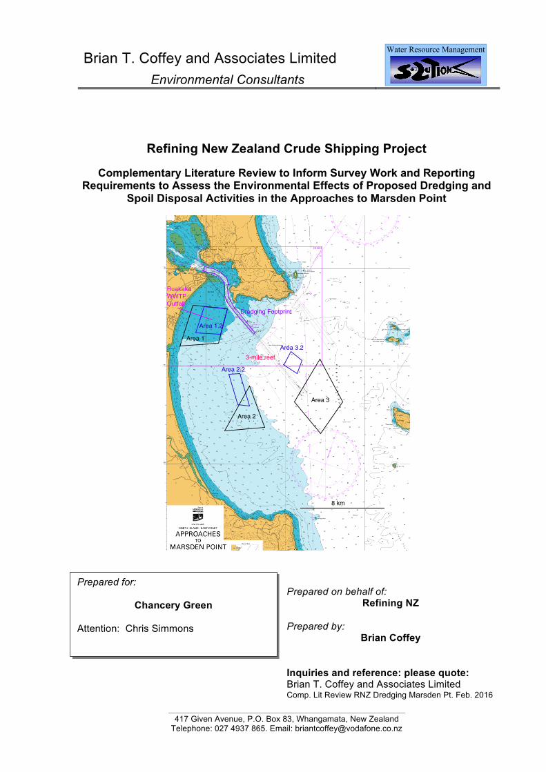
Brian T. Coffey and Associates Limited Environmental Consultants 417 Given Avenue, P.O. Box 83, Whangamata, New Zealand Telephone: 027 4937 865. Email: [email protected] Water Resource Management Refining New Zealand Crude Shipping Project Complementary Literature Review to Inform Survey Work and Reporting Requirements to Assess the Environmental Effects of Proposed Dredging and Spoil Disposal Activities in the Approaches to Marsden Point Prepared on behalf of: Refining NZ Prepared by Brian Coffey Inquiries and reference: please quote: Brian T. Coffey and Associates Limited Comp. Lit Review RNZ Dredging Marsden Pt. Feb. 2016 8 km Area 1 Area 2 Area 3 Area 3.2 Area 2.2 Dredging Footprint 3-mile reef Area 1.2 Ruakaka WWTP Outfall Prepared for: Chancery Green Attention: Chris Simmons
Transcript of Water Resource Management Brian T. Coffey and ......Brian T. Coffey and Associates Limited...
Brian T. Coffey and Associates Limited Environmental Consultants
417 Given Avenue, P.O. Box 83, Whangamata, New Zealand
Telephone: 027 4937 865. Email: [email protected]
Water Resource Management
Refining New Zealand Crude Shipping Project
Complementary Literature Review to Inform Survey Work and Reporting Requirements to Assess the Environmental Effects of Proposed Dredging and
Spoil Disposal Activities in the Approaches to Marsden Point
Prepared on behalf of:
Refining NZ Prepared by
Brian Coffey
Inquiries and reference: please quote: Brian T. Coffey and Associates Limited Comp. Lit Review RNZ Dredging Marsden Pt. Feb. 2016
8 km
Area 1
Area 2
Area 3
Area 3.2
Area 2.2
Dredging Footprint
3-mile reef
Area 1.2
Ruakaka WWTP Outfall
Prepared for:
Chancery Green Attention: Chris Simmons
Brian T. Coffey and Associates Limited, Whangamata
1 1.0 Introduction and Background Refining NZ propose to deepen and partially realign the approaches to Marsden Point.
The dredging and spoil disposal works involved in this proposal require resource consents and applications for these consents require an assessment of environmental effects (AEE) for the proposed activities in the coastal marine area.
Whilst the specific details of the dredging programme have yet to be finalised, it is expected that some 3.3x10⁶ m3 of dredged material will be involved in the dredging and spoil disposal works (West et. al., 2015b).
The Environment Foundation (2015) environment guide1 makes the following comments with regard to marine dredging and spoil disposal projects.
The main environmental impacts from dredging and marine disposal are related to the following.
• Direct disturbance and physical changes to the seabed.
• Suspension of sediment and associated changes in water quality.
• Release and re-mobilisation of contaminants on or in the seabed.
• Changes in local hydrodynamics and settlement patterns of sediment.
Capital dredging necessarily removes flora and fauna from the seabed and increases its depth. Depending on the depth of dredging, the activity may completely remove all life from the sea floor for a period of time. The recovery rate of the benthic communities will depend on the particular nature of the ecosystem: some ecosystems dominated by opportunistic species may recover in only a few months, whereas those populated by slow growing, sensitive species may take years, or may never recover.
Maintenance dredging usually involves frequent removal of material and the amount removed differs considerably depending on the site and type of development. For example, Pine Harbour maintains the channel by dredging 3000 m3 per year, Westpark Marina dredges up to 10,000 m3 per year and the Lyttelton Port maintenance dredging has varied between 290,000m3 to 800,000m3 per year over the past 10 years.
The impact of maintenance dredging on the seabed is usually less than capital works, because the activity is taking place in an area which has already been disturbed, and the organisms that have re-colonised the area are likely to be more resilient.
Dredging and disposal can also discharge sediment into the water column:
• as the seabed is disturbed by the dredge,
• when sediment overflows from hoppers and barges carrying the dredged material,
• as the sediment is dumped at a marine disposal site, and
• by re-suspension of material at the disposal site.
Disposal of the dredged material has a number of environmental impacts. There are generally limited opportunities to dispose of dredged material for beneficial reuse, such as beach re-nourishment or in reclamations. Land disposal is typically too costly and impracticable which means that marine disposal is often the option of choice. When dredged material is disposed of in the marine environment it can smother the benthic fauna in the immediate disposal area, as well as lead to an increased water turbidity. It is important that disposal sites are chosen to ensure that the impacts are isolated to these locations and the plumes are generally localised. For example, Ports of Auckland disposes of some dredgings from its dredging programmes,
1 http://www.environmentguide.org.nz/issues/marine/major-marine-development.
Brian T. Coffey and Associates Limited, Whangamata
2 including from the Port of Onehunga, in the Fergusson reclamation where the dredged material is mixed with cement to make mudcrete for the reclamation.
There are concerns over the re-suspension of sediment and impact on local ecosystems from the disposal sites in the inner harbour areas. Historically, dredged material from the Pine Harbour Marina in Auckland Harbour has been disposed of locally. In 2009 the marina sought a resource consent to dispose of 3000 m3 annually off Motukaraka Island nearby the marina. Local concern about the impact of the disposed sediment on cockle and pipi beds and sea grass played a part in the consent being declined. The marina now has permission from Maritime New Zealand to dispose of the sediment in deep water (140 m) off Great Barrier Island (Flaim, 2008).
Where sediment is released into the water column, it can affect the clarity and turbidity of the water, potentially reducing light penetration. The suspended material may eventually settle on areas around the dredged site, blanketing the benthic animals and plants that live there. The effects of this will vary, depending on the resilience of the communities, and the conditions that they are used to, but may cause stress, reduced rates of growth or fatalities. Suspended sediment from maintenance dredging is likely to have less impact than that from capital dredging, due to the already disturbed nature of the site and the lower volume of spoil involved.
Some animals are more sensitive to siltation than others. Shellfish, which have delicate feeding and breathing apparatus, may be affected by increases in sedimentation. Similarly, sediment can become trapped in the gills of young fish causing increased fatalities, and smothering of spawning or nursery areas for fish can result in the death of eggs and larvae. This could potentially reduce the level of recruitment for harvestable fisheries. Lastly, smothering of intertidal areas may result in decreased availability of food for the birds and fish that feed there.
In some areas where dredging is commonly undertaken, such as at the entrances to ports and marinas, the sediment on the seabed can often have an elevated level of contaminants due to land catchment run-off and / or spillages / antifoul use in marina and harbours. Dredging can re-mobilise contaminants accumulated in these areas and potentially re-disperse them further away. The level of risk from this is based on the:
• actual concentration / load of contaminants present within the proposed dredging footprint
• degree of remobilisation,
• patterns of dispersal,
• sediment size and quality,
• bioavailability and toxicity of the contaminants, and
• sensitivity of species in the downstream area.
Issues associated with dredging and dredging spoil disposal are also covered by Section 22 of the Regional Coastal Plan for Northland (Northland Regional Council, 2004).
Therefore, an assessment of ecological effects in this context involves a consideration of water quality, sediment grain size, sediment quality in terms of potential contaminants, plankton, seagrasses, benthic algae, benthic invertebrates, fish, marine mammals and seabirds within the study area.
It also involves the recognition of which particular benthic communities in the vicinity of the dredging and spoil disposal footprints are most sensitive to potential sedimentation / toxicity effects and to target these as indicators of ecological effects.
2.0 Current Situation Clement and Elvines (2015) have provided a review of marine mammals that could potentially be affected by proposed works.
Brian T. Coffey and Associates Limited, Whangamata
3 Pine and Styles (2015) have conducted a short-term passive underwater acoustic survey at Marsden Point and the harbour entrance to inform studies by Clement and Elvines (2015).
West and Don (2015) have provided a literature review of birds, seagrass, benthic algae, benthic invertebrates, fish communities, sediment type and sediment quality that could potentially be affected by proposed works and have made recommendations on further ecological survey work that is required to support resource consent applications. In their opinion, available information is largely out of date and needs to be updated.
This additional work is being undertaken by Kerr and Associates who have completed Phase I descriptions of benthic communities in the immediate surrounds of the proposed dredging footprint. The selection of benthic habitats to be sampled in Phase II studies will be based on the known sensitivity of particular community types that are present to sedimentation effects, and the occurrence of like community types at different distances from the dredged footprint.
West and Don (in prep.) are describing surficial sediment particle size and quality (in terms of contamination status) within the proposed dredging footprint in the approaches to Marsden Point (see Figure 1). They are also documenting benthic communities that inhabit surficial sediments within the proposed dredging footprint in the approaches to Marsden Point on the basis of 117 Ponar grab samples (Bioresearches, 2015).
West et. al. (2015) have provided a preliminary environmental assessment of three potential dredge spoil disposal areas in Bream Bay (Areas 1, 2 and 3 – see cover plate).
Kerr and Associates are conducting field work to assess further potential offshore disposal sites for dredged spoil in Bream Bay (e.g. see Areas 2.2 and 3.2 on the cover plate) and Bioresearches are involved with ongoing bird surveys in the surrounds of Marsden Point.
Given this background there are therefore, two particular matters that have not been covered by works conducted and / or proposed by Bioresearches and others at this stage. These are water quality considerations (because sedimentation / turbidity effects are transported from the footprint of dredging and / or spoil disposal areas as plumes in the water column) and a sensitivity analysis for adjacent communities that may be affected by sediment plumes generated by dredging and / or spoil disposal activities.
This document accepts and endorses the baseline literature review on the natural environment of Whangarei Heads, Bream Bay and its adjacent coastline conducted by West and Don (2015), but complements it with a consideration of water quality effects and a sensitivity analysis for benthic communities adjacent to the proposed footprint of dredging activities / spoil disposal sites. It is considered these two additional considerations are necessary to meet the full requirements of a robust AEE for the proposed dredging and spoil disposal activities. It provides Refining NZ with a basis for proceeding to Stage II ecological and water quality investigations.
3.0 Water Quality Considerations It is expected that conditions of resource consent for the proposed dredging and spoil disposal activities will include monitoring of water column conditions for suspended solid concentrations, turbidity and potential contaminant concentrations associated with material to be dredged and disposed of during disturbance activities. These water column effects are associated with potential changes in benthic community structure and plankton communities within the approaches to Marsden Point.
The AEE will assess whether changes in water column conditions due to disturbance activities are likely to be ecologically acceptable and if not, what mitigation / avoidance measures are available and appropriate. This assessment should relate to background conditions that these communities can currently tolerate (in terms of suspended solid concentrations, turbidity and potential contaminant concentrations).
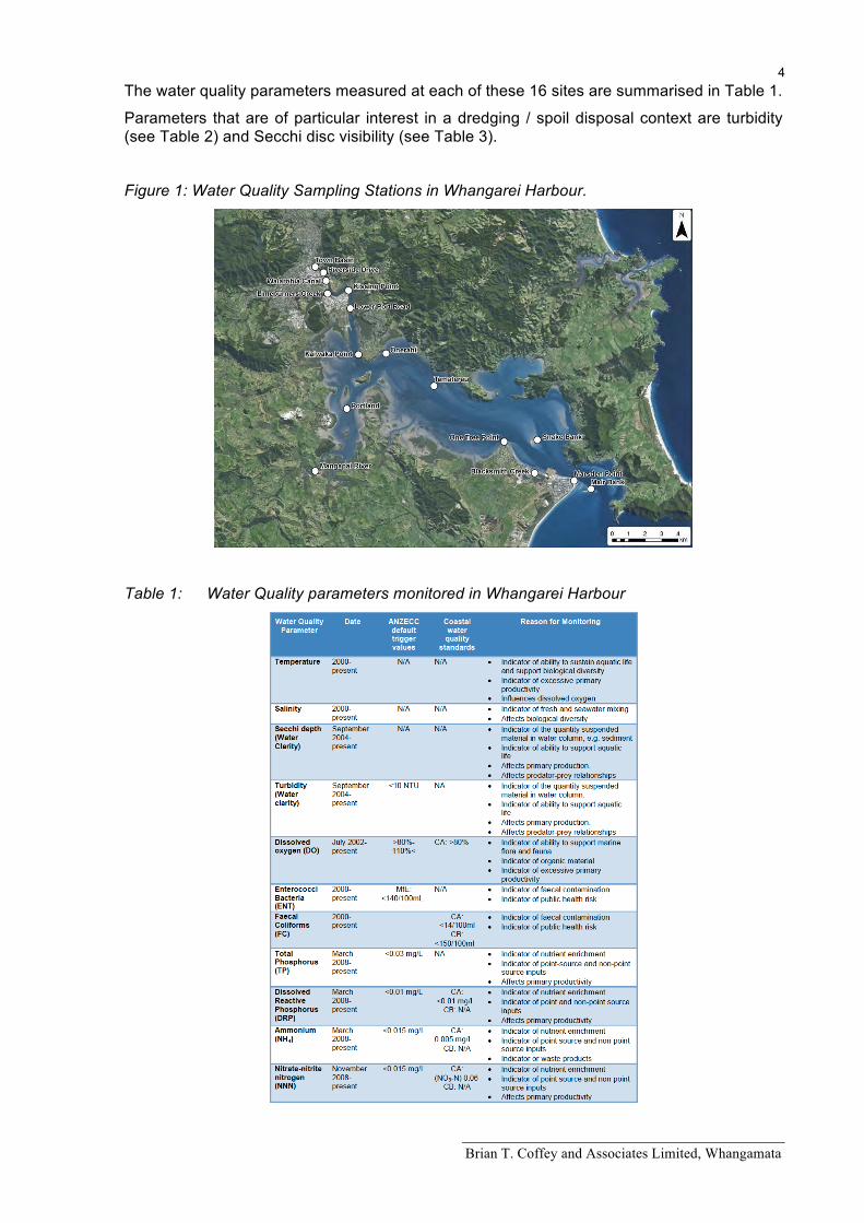
There is a comprehensive water quality data base available for Whangarei Harbour (Northland Regional Council, 2011) and water quality sampling sites are shown in Figure 1.
Brian T. Coffey and Associates Limited, Whangamata
4 The water quality parameters measured at each of these 16 sites are summarised in Table 1.
Parameters that are of particular interest in a dredging / spoil disposal context are turbidity (see Table 2) and Secchi disc visibility (see Table 3).
Figure 1: Water Quality Sampling Stations in Whangarei Harbour.
Table 1: Water Quality parameters monitored in Whangarei Harbour
Brian T. Coffey and Associates Limited, Whangamata
5 Table 2: Range and median value for turbidity (NTU) at 16 sites in Whāngārei Harbour,
2000-2010.
Site Name No. of Samples
Range (NTU) Median (NTU) % of samples within guideline value (<10 NTU)
One Tree Point 25 0.5 – 5.7 1.0 100 Blacksmith’s Creek 18 1.0 – 3.4 1.0 100 Marsden Point 38 0.4 – 6.6 1.0 100 Mair Bank 39 0.2 – 2.4 1.0 100 Snake Bank 18 1.0 – 15.3 2.1 94 Tamaterau 39 1.0 – 37.0 2.9 92 Town Basin 25 3.4 – 63.0 5.0 92 Onerahi 18 2.5 – 12.4 5.1 89 Lower Port Road 18 3.6 – 11.9 5.4 89 Kaiwaka Point 22 3.4 – 11.7 5.4 91 Kissing Point 50 2.8 – 92.0 5.4 94 Riverside Drive 18 3.4 – 11.1 5.7 94 Waiharohia Canal 18 3.4 – 13.2 6.6 83 Portland 18 4.0 – 18.1 7.4 78 Limeburners Creek 25 4.1 – 67.0 7.9 88 Mangapai 18 4.6 – 15.2 9.3 67
The ANZECC (2000) default trigger values for turbidity in estuarine and marine environments is 0.5-10 NTU. None of the sites had median values for turbidity that exceeded 10 NTU (see Table 2). The highest median values for turbidity (lowest water clarity) were found at sites close to freshwater inputs in the Mangapai River and the Hātea River. Sites with the lowest median turbidity (highest water clarity) were located near the harbour entrance at One Tree Point, Blacksmith’s Creek, Marsden Point and Mair Bank, where freshwater inflows are likely to have less influence on water quality
Table 3: Range and median value for Secchi depth visibility in Whāngārei Harbour, 2000-2010.
Site Name No. of Samples
Range (m) Median (m) % of samples within guideline value
Marsden Point 37 0.9 – 9.0 4.5 N/A Blacksmith’s Creek 15 1.6 – 6.0 4.0 N/A Mair Bank 34 1.8 – 7.5 3.85 N/A One Tree Point 24 2.0 – 6.3 3.8 N/A Snake Bank 14 1.3 – 7.0 3.65 N/A Tamaterau 33 0.3 – 4.7 2.4 N/A Onerahi 17 0.9 – 2.2 1.5 N/A Kaiwaka Point 18 0.47 – 1.8 1.4 N/A Lower Port Road 17 0.8 – 1.7 1.3 N/A Portland 17 0.6 – 2.1 1.3 N/A Town Basin 18 0.5 – 1.9 1.23 N/A Kissing Point 47 0.15 – 2.1 1.2 N/A Waiharohia Canal 17 0.7 – 2.0 1.1 N/A Riverside Drive 17 0.7 – 1.8 1.0 N/A Limeburners Creek 21 0.3 – 2.2 1.0 N/A Mangapai 17 0.2 – 1.5 0.9 N/A
There are currently no ANZECC default trigger values for Secchi depth. A similar spatial trend to turbidity was observed for locations with the lowest median Secchi depths (lowest water clarity) found in the Hātea River and Mangapai River, and the highest median Secchi depths (highest water clarity) found near the harbour entrance.
Both Secchi depth and turbidity are a measure of water clarity. Water clarity can be reduced by the growth of phytoplankton and human activities that increase levels of suspended solids entering the coastal environment. High levels of material in the water column can restrict light
Brian T. Coffey and Associates Limited, Whangamata
6 transmission which affects the amount of photosynthesis (primary production) of aquatic plants and consequently other species that are dependent on them such as fish, zooplankton and shellfish. Seaweeds and seagrass typically require more light for photosynthesis than phytoplankton and are particularly susceptible to reduced light levels of suspended sediments by nature of being attached to the seabed (Thrush et al., 2004). Suspended sediments can also clog fish gills and reduce the ability of fish to see prey and detect predators (ANZECC, 2000).
In terms of the harbour data, there was a significant trend (between 2000 and 2010) of increasing turbidity at the Riverside Sampling Site that was undesirable, increasing water clarity at Kissing Point that was desirable, increasing turbidity at Onerahi that was undesirable, and increasing water clarity at Marsden Point and Mair Bank that was desirable.
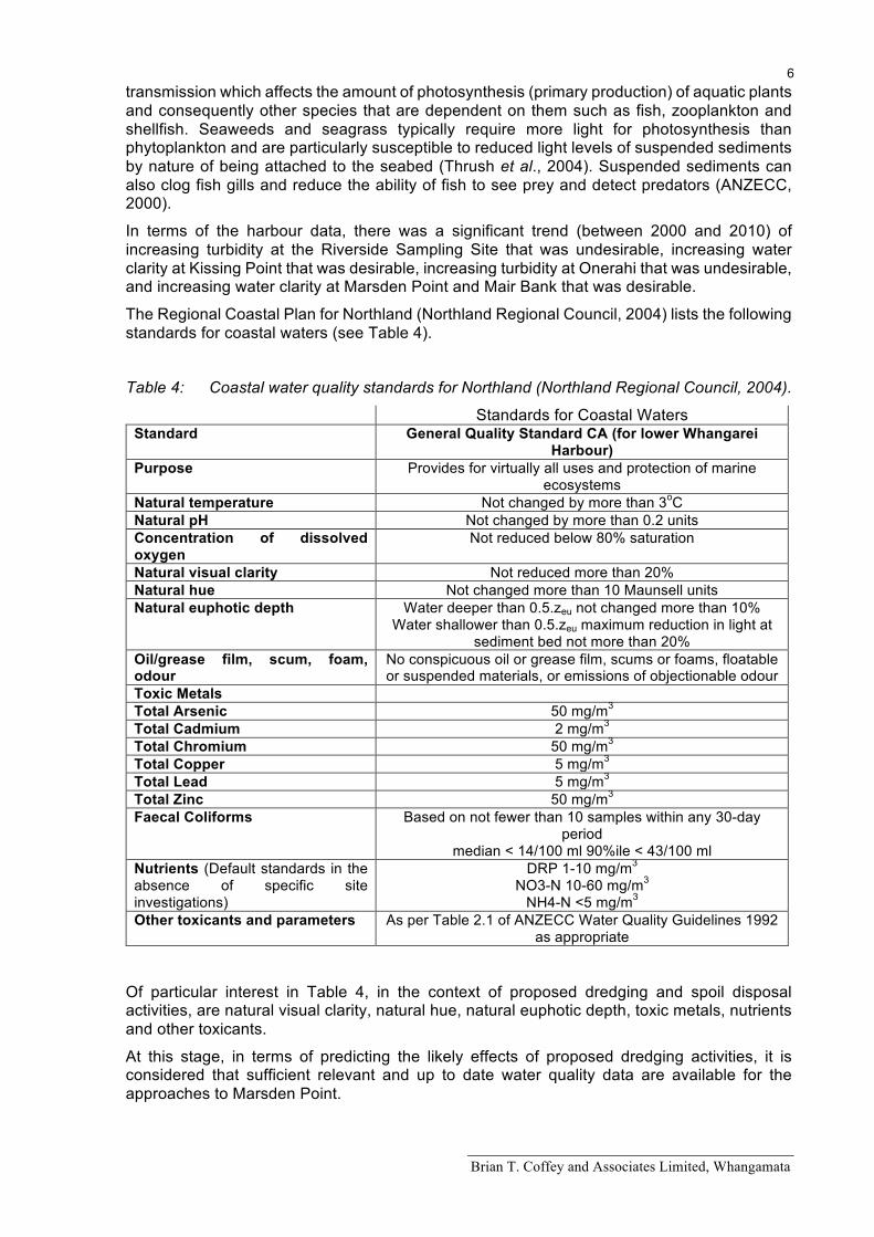
The Regional Coastal Plan for Northland (Northland Regional Council, 2004) lists the following standards for coastal waters (see Table 4).
Table 4: Coastal water quality standards for Northland (Northland Regional Council, 2004).
Standards for Coastal Waters Standard General Quality Standard CA (for lower Whangarei
Harbour) Purpose Provides for virtually all uses and protection of marine
ecosystems Natural temperature Not changed by more than 3oC Natural pH Not changed by more than 0.2 units Concentration of dissolved oxygen
Not reduced below 80% saturation
Natural visual clarity Not reduced more than 20% Natural hue Not changed more than 10 Maunsell units Natural euphotic depth Water deeper than 0.5.zeu not changed more than 10%
Water shallower than 0.5.zeu maximum reduction in light at sediment bed not more than 20%
Oil/grease film, scum, foam, odour
No conspicuous oil or grease film, scums or foams, floatable or suspended materials, or emissions of objectionable odour
Toxic Metals Total Arsenic 50 mg/m3 Total Cadmium 2 mg/m3 Total Chromium 50 mg/m3 Total Copper 5 mg/m3 Total Lead 5 mg/m3 Total Zinc 50 mg/m3 Faecal Coliforms Based on not fewer than 10 samples within any 30-day
period median < 14/100 ml 90%ile < 43/100 ml
Nutrients (Default standards in the absence of specific site investigations)
DRP 1-10 mg/m3 NO3-N 10-60 mg/m3
NH4-N <5 mg/m3 Other toxicants and parameters As per Table 2.1 of ANZECC Water Quality Guidelines 1992
as appropriate
Of particular interest in Table 4, in the context of proposed dredging and spoil disposal activities, are natural visual clarity, natural hue, natural euphotic depth, toxic metals, nutrients and other toxicants.
At this stage, in terms of predicting the likely effects of proposed dredging activities, it is considered that sufficient relevant and up to date water quality data are available for the approaches to Marsden Point.
Brian T. Coffey and Associates Limited, Whangamata
7 MWH (2011) also summarised available water quality data for the wider environs of Bream Bay when assessing the effects of the Ruakaka Wastewater Project that discharges treated wastewater to Bream Bay via an ocean outfall diffuser.
These water quality data were sourced from field sampling that was undertaken by Northland Regional Council staff for Whangarei District Council at 9 sites in Bream Bay, Whangarei Harbour entrance and Ruakaka River over the period June 2008 to May 2009 (Sites 1 to 4 are relevant to this particular project). Surface water samples were collected on 7 occasions, including ebb and flood tides, and dry and wet weather.
In addition to the description of surficial sediments within the dredging footprint being prepared by Bioresearches (see page 3), a further series of 20 vibracores are to be obtained for the full dredging profile.
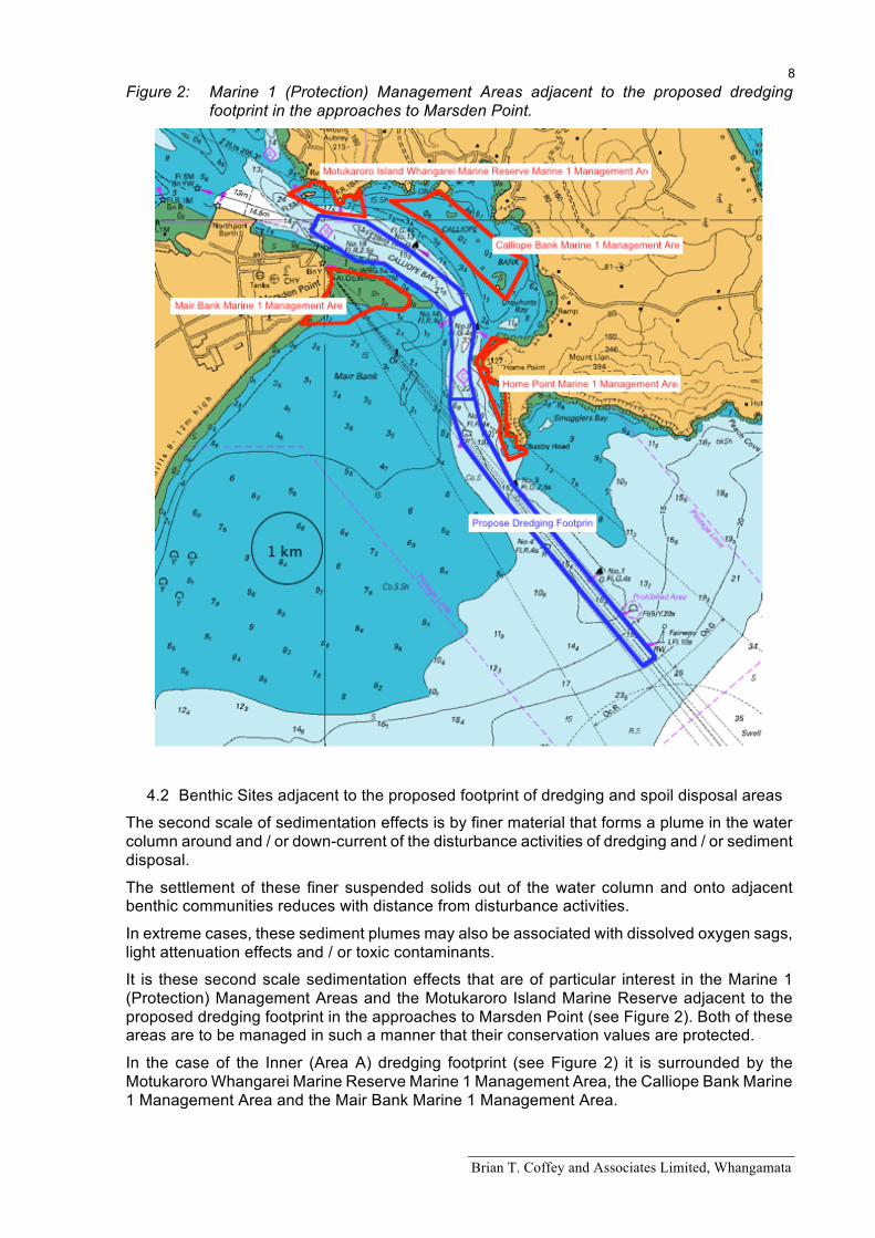
In the unexpected event that these deeper vibracores from the proposed dredging footprint find dredged spoil will include contaminated or muddy sediments, it will be necessary to consider the most appropriate dredging and disposal strategies for these particular materials to avoid adverse environmental effects. Particular attention will need to be given to potential effects on Marine 1 (Protection) Management Areas adjacent to the proposed dredging footprint (see Figure 2).
Assessment protocols for describing and managing potentially contaminated sediments in this context are covered by the New Zealand Guidelines for Sea Disposal of Waste (Maritime Safety Authority of New Zealand, 1999).
4.0 Sensitivity Analysis for Benthic Communities in the vicinity of dredging and spoil disposal activities
Given the volume of open seawater entering and discharging from Whangarei Harbour during two tidal cycles per day, it is most unlikely that proposed dredging or spoil disposal activities will have any measureable effect on plankton communities or communities that rely on plankton quality and quantity as a food source, within or adjacent to the approaches to Marsden Point.
However, this should be confirmed or refuted by MetOcean modelling studies.
There are two scales of potential sedimentation effects on benthic communities that may be associated with this project.
4.1 Spoil Disposal Sites
Within spoil disposal sites, dredged material could be placed at a thickness of up to 10% of water depth and it can be conservatively assumed that all resident biota would be effectively buried by the dredged spoil footprint.
In this regard, the principle of placing “like on like” (in terms of sediment particle size and the contamination status of dredged spoil and surficial sediments at the spoil disposal site) maximises the likelihood of similar pre-impact benthic community types recolonising spoil disposal sites. It is intended to select a number of candidate spoil disposal sites to maximise opportunities for “like on like” spoil disposal (see cover plate).
Moreover, if material is placed in bands (c. 10% of water depth – Maritime Safety Authority of New Zealand, 1999) rather than covering the full footprint of the disposal area, recolonisation of placed sediment from less disturbed intermediate areas within the disposal footprint would be expected to assist the rate of recolonisation of placed spoil material.
On this basis, the recovery of the spoil disposal sites can be predicted and monitored.
Brian T. Coffey and Associates Limited, Whangamata
8 Figure 2: Marine 1 (Protection) Management Areas adjacent to the proposed dredging
footprint in the approaches to Marsden Point.
4.2 Benthic Sites adjacent to the proposed footprint of dredging and spoil disposal areas
The second scale of sedimentation effects is by finer material that forms a plume in the water column around and / or down-current of the disturbance activities of dredging and / or sediment disposal.
The settlement of these finer suspended solids out of the water column and onto adjacent benthic communities reduces with distance from disturbance activities.
In extreme cases, these sediment plumes may also be associated with dissolved oxygen sags, light attenuation effects and / or toxic contaminants.
It is these second scale sedimentation effects that are of particular interest in the Marine 1 (Protection) Management Areas and the Motukaroro Island Marine Reserve adjacent to the proposed dredging footprint in the approaches to Marsden Point (see Figure 2). Both of these areas are to be managed in such a manner that their conservation values are protected.
In the case of the Inner (Area A) dredging footprint (see Figure 2) it is surrounded by the Motukaroro Whangarei Marine Reserve Marine 1 Management Area, the Calliope Bank Marine 1 Management Area and the Mair Bank Marine 1 Management Area.
Brian T. Coffey and Associates Limited, Whangamata
9 In the case of the mid (Area B) dredging footprint (see Figure 2), whilst it is bordered on its eastern side by the Home Point Marine 1 Management Area, there is not a lot of material to be dredged from this area.
In the case of the outer (Area C) dredging footprint (see Figure 2), whilst it involves a large quantity of material to be dredged, it is relatively remote from Marine 1 Management Areas.
West and Don (2015) recommended further ecological survey work is required to support resource consent applications because available information is largely out of date.
However, it was considered that a more cost effective approach would involve a two-phase strategy to firstly review what communities are currently adjacent to the footprint of the proposed dredging and spoil disposal footprints and to then select and describe “indicator communities” in the footprint of the proposed dredging and spoil disposal footprints as Phase II of the investigation.
There have been a range of studies that have assessed the sensitivity of benthic taxa in northern North Island estuaries and harbours to stressors including sedimentation (see Appendix A.
The most recent and extensive investigation into the effects of sedimentation on estuarine and harbour benthic invertebrates has been undertaken in the Waikato Region by Needham et. al. (2014). They have proposed the following Indicator taxa for harbours and estuaries in northern North Island.
A. Intertidal soft shores
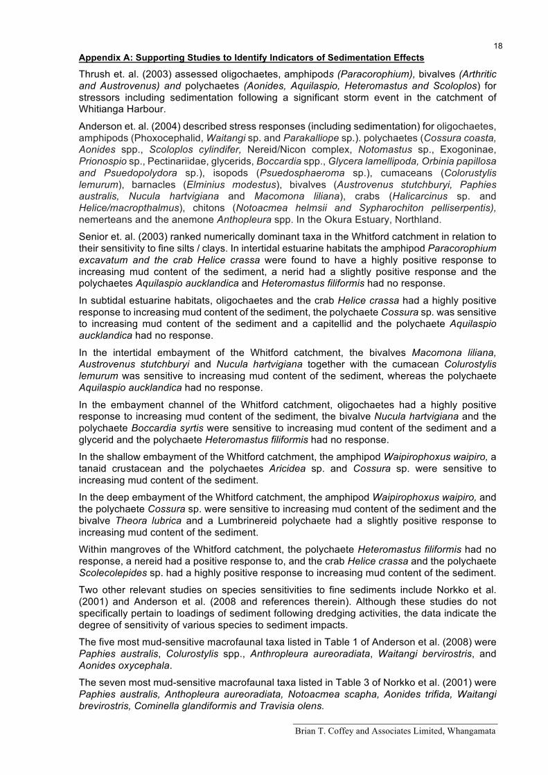
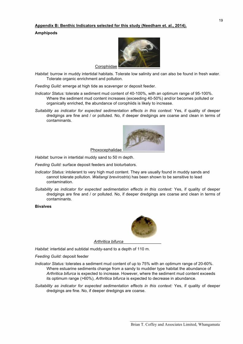
Amphipods (Corophiidae and Phoxocephalidae)
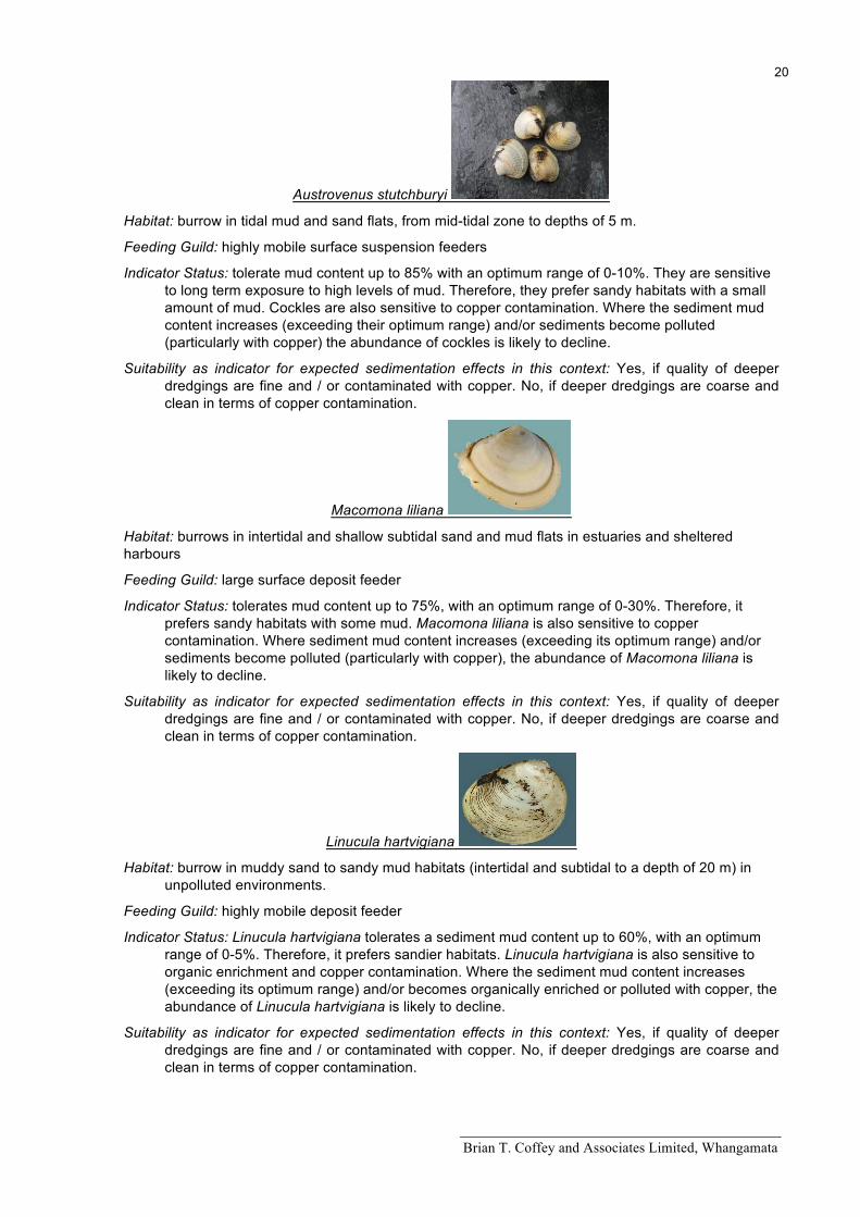
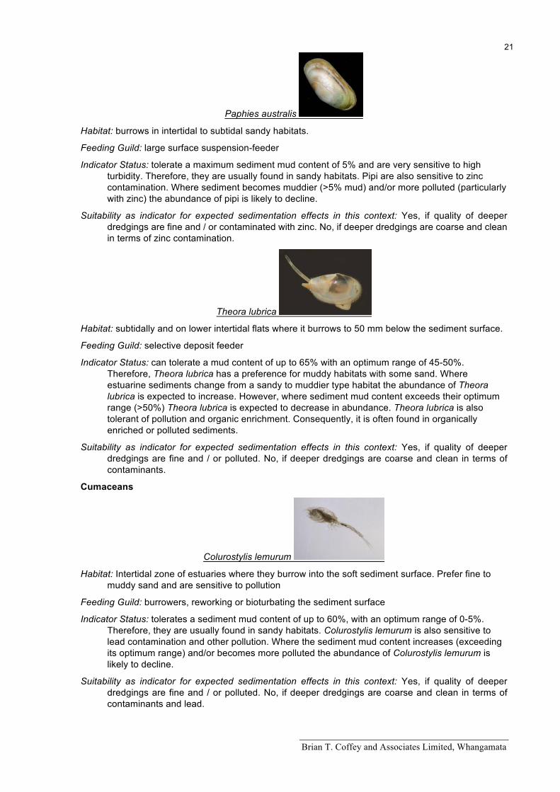
Bivalves (Arthritica bifurca, Austrovenus stutchburyi, Macomona Liliana, Linucula hartvigiana, Paphies australis, Theora lubrica)
Cumaceans (Colurostylis lemurum)
Gastropods (Cominella adspersa)
Chiton (Notoacmea spp.)
Polychaetes (Prionospio aucklandica, Aglaophamus macroura, Aonides trifida, Aricidea spp. Pseudopolydora complex, Cossura consimilis, Euchone spp., Goniada spp., Glycera spp., “Capitellidae”, Magelona cf. dakini, Orbinia papillosa, Paraonidae)
Anthozoan (Anthopleura aureoradiata)
B. Subtidal soft shores
B1 Shallow subtidal soft shores
Amphipods (Phoxocephalidae)
Bivalves (Arthritica bifurca, Linucula hartvigiana, Austrovenus stutchburyi, Macomona liliana, Paphies australis, Theora lubrica
Gastropods (Cominella adspersa)
Polychaetes (Aglaophamus verrilli, Aonides trifida, Aricidea spp., Pseudopolydora complex, Cossura consimilis, Euchone spp. Goniada spp., Glycera spp., “Capitellidae”, Magelona cf. dakini, Orbinia papillosa, Paraonidae)
B2 Deeper subtidal soft shore
Amphipods (Phoxocephalidae)
Bivalves (Arthritica bifurca, Linucula hartvigiana)
Polychaetes (Aonides trifida, Aricidea spp. Cossura consimilis, Euchone spp., Goniada spp., Glycera spp., Magelona cf. dakini, Orbinia papillosa, Paraonidae)
Brian T. Coffey and Associates Limited, Whangamata
10 These taxa and their specific indicator status listed in Appendix B will be used to select sampling sites for Phase II ecological studies / surveys.
Most of these taxa are in common with those identified by Thrush et. al. 2003; Anderson et. al. 2004; Senior et. al. 2003; Norkko et al. 2001 and Anderson et al. 2008 (see Appendix A).
There will also be other special interest communities dominated by taxa such as anemones (e.g. Anthothoe albocincta), horse mussels (Atrina zelandica), a turret shell (Maoricopus rosea) / dog cockle (Glcymeris modesta / Tucetona laticostata) community and subtidal rocky reef sponge garden sites in Marine 1 (Protection) Management Areas adjacent to the proposed dredging footprint that may be described as a time sequence comparison immediately before and after dredging / spoil disposal disturbance activities.
In this regard, MacDiarmid et. al. (2013) have identified the following biogenic (biologically formed) and geological environments as sensitive within New Zealand Exclusive Economic Zone and Continental Shelf to help inform the the Exclusive Economic Zone and Continental Shelf (Environmental Effects) Act 2012.
• Beds of large bivalve molluscs • Brachiopod beds • Bryozoan beds • Calcareous tube worm thickets • Chaetopteridae worm fields • Deep-sea hydrothermal vents • Macro-algal beds • Methane or cold seeps • Rhodolith (maerl) beds • Sea pen fields • Sponge gardens • Stony coral thickets or reefs • Xenophyophores (sessile protozoan) beds
On this basis, the canopy cover and health of mixed weed communities and Ecklonia forest on rocky reefs within the vicinity of the proposed dredging footprint will also be considered for monitoring before and after proposed dredging activities.
Brian T. Coffey and Associates Limited, Whangamata
11 Bibliography
Acosta, H., Taylor, R. B., & Tricklebank, K. A., 2003: A baseline survey for monitoring future effects of the Marsden Point deepwater port development on the subtidal ecology of the Whangarei Harbour. Report to Northland Regional Council, Whangarei. University of Auckland. 40 p.
Anderson, M. J., Ford, R. B., Feary, D. A., & Honeywill, C., 2004: Quantitative measures of sedimentation in an estuarine system and its relationship with intertidal soft-sediment fauna. Marine Ecology Progress Series. 272: 33–48.
Anderson, M. J., 2008: Animal-sediment relationships re-visited: Characterising species' distributions along an environmental gradient using canonical analysis and quantile regression splines. Journal of Experimental Marine Biology and Ecology 366: 16–27.
Andries, C., 2010: Water Resources in the Whangarei District. Sustainable Futures 30\50 Whangarei District.
ANZECC, 2000: Australian and New Zealand Guidelines for Fresh and Marine Water Quality, Volume 1, The Guidelines (Chapters 1-7). Australian and New Zealand Environment and Conservation Council (ANZECC) and Agriculture and Resource Management Council of Australia and New Zealand (ARMCANZ). Paper No. 4 - Volume 1 (Chapters 1-7) October 2000.
Beca Planning, 2002: Whangarei Coastal Management Strategy. District Wide Strategy. Report prepared for Whangarei District Council, September 2002.
Bioresearches Ltd., 1976: Aspects of the Ecology of the area surrounding the Oil Refinery at Marsden Point. For New Zealand Refining Company Ltd. July 1976.
Bioresearches Ltd., 1978: The Monitoring of Marine Habitats in the vicinity of Marsden Point Refinery. Report No.1. For New Zealand Refining Company Ltd.
Bioresearches Ltd., 1979: The Monitoring of Marine Habitats in the vicinity of Marsden Point Refinery. Report No.2. For New Zealand Refining Company Ltd.
Bioresearches Ltd., 1982: The Monitoring of Marine Habitats in the vicinity of Marsden Point Refinery. Report No.3. For New Zealand Refining Company Ltd.
Bioresearches Ltd., 1982b: Metals in Shellfish and Sediments from the Marsden Point Area. June 1982. For New Zealand Refining Company Limited. 13 p.
Bioresearches Ltd., 1982c: Refinery Effects on Metals in Shellfish and Sediments from the Marsden Point Area. October 1982. For New Zealand Refining Company Limited. 32 p.
Bioresearches, 2002: Marsden Cove Ecological Assessment. 118 pp + Appendices & Plates. (For Marsden Cove Ltd)
Bioresearches, 2014: Post-Commissioning Intertidal and Marina Basin Monitoring Survey No.6 2013-14. 56 pp. For Marsden Cove Ltd.
Bioresearches, 2015: Refining New Zealand. Proposed Methodology for Pre-dredging Characterisation of Marsden Point Oil Refinery Channel Option 16.8 m with 1:10 batter. Bioresearches 3 February 2015.
Breen, P. A., 2000: A Bayesian length-based stock assessment model for cockles (Austrovenus stutchburyi) on Snake Bank, Whangarei Harbour. Draft New Zealand Fisheries Assessment Report.
Brook, F.J., 1997: Evidence of Fred Brook. The hearing of submissions on coastal, water and discharge permits and land use applications by Northland Port corporation for resource consents relating to the proposed construction and operation of a deep water bulk cargo port terminal and port related facilities and activities at Marsden Point, Whangarei Harbour. (NRC Application No. 5055 and WEC Application No. 96/316 refer). 17 p.
Brian T. Coffey and Associates Limited, Whangamata
12 Brook, F.J., 2002: Biogeography of near-shore reef fishes in northern New Zealand.
Journal of the Royal Society of New Zealand. 2: 243–274.
Chetham, J., 2014: Patuharakeke Hapu Environmental Management Plan 2014. Published in December 2014 by Patuharakeke Te Iwi Trust Board Inc.
Clement, D. and Elvines, D., 2015: Draft Review of Marine Mammal Populations and Effects of Dredging/Spoil Disposal in Whangarei Harbour. A report prepared for Refining NZ Ltd by the Cawthron Institute, Report N0. XXXX, May 2015.
Coffey, B., 1999: Assessment of Effects of Discharge to Limeburners Creek, Whangarei Harbour, August 1999. Brian T. Coffey and Associates Limited. AEE: Whangarei WWTPD - H/G / WDC, 08.1999. A report prepared for Harrison Grierson Consultants Limited, P.O. Box 5760 Wellesley St, Auck.
Coffey, B., 2004: Ruakaka and One Tree Point Wastewater Treatment Plant Assessment of Ecological Effects. Prepared by Brian T. Coffey and Associates Limited for Whangarei District Council on behalf of Harrison Grierson Consultants Ltd. WDC/HG[2]. 10 2004.
Conwell, C., Clement, D., 2009: Assessment of Effects of Endocrine Disrupting Compounds and Microbiological Pathogens on the Fish and Marine Mammals of Bream Bay. Prepared for Whangarei District Council, by Cawthron Institute.
Cornelisen, C., Jiang, W. and Griffiths, R., 2011: Interpreting Northland’s Coastal Water Quality Monitoring Results under Different Tide Conditions. Prepared for Northland Regional Council. Cawthron Report No. 2026. 36p. plus appendices.
Cryer, M. and Holdsworth J., 1993: Productivity estimates for Snake Bank cockles, August 1992 to August 1993. Unpublished Internal Report, held at NIWA, Auckland.
Cryer, M., 1997: Assessment of cockles on Snake Bank, Whangarei Harbour, for 1996. New Zealand Fisheries Assessment Research Document 97/2. 29 p.
Cryer, M., Smith, M., Parkinson, D., MacKay, G. and Tasker, R., 2003: Biomass surveys of cockles in Whangarei Harbour, 2002. Final Research Report for MFish Project COC2001/01, Objective 3. 6 p.
Cryer, M., Watson, T. G., Smith, M. D.; MacKay, G. and Tasker, R., 2004: Biomass survey and stock assessment of cockles on Snake Bank, Whangarei Harbour, 2003. Final Research Report for Ministry of Fisheries Research Project COC2002/01. Unpublished report held by Ministry of Fisheries, Wellington
Cummings, V. and Hatton, S., 2003: Towards the long term enhancement of shellfish beds in Whangarei Harbour. Part One: Identifying suitable habitat and methodologies for reseeding. NIWA Client Report Ham2003-042, May 2003.
Cummings, V., 2006: Coastal Restoration. Giving our estuaries a helping hand: restoring shellfish beds in Whangarei Harbour. Water & Atmosphere 14(1) 2006.
Dickie, B. N, 1986a: Physical and biological survey of a subtidal Paphies australis population in the lower Whangarei Harbour. Whangarei Water Quality Management Plan. Working Report 4. 45 p. (Unpublished report to the Northland Catchment Commission and Regional Water Board, New Zealand).
Dickie, B. N., 1984a: Soft shore investigations. Whangarei Harbour Study. Northland Harbour Board. Technical report No 4
Dickie, B. N., 1984b: Wading birds: high tide roost surveys (OSNZ) data. Whangarei Harbour study. Northland Harbour Board. Technical Report No. 5. 68p.
Dickie, B. N., 1984c: Rocky shore investigations Part I. Site descriptions: Physical and Biological. Whangarei Harbour study. Northland Harbour Board. Technical Report No. 7. 81 p.
Brian T. Coffey and Associates Limited, Whangamata
13 Dickie, B. N., 1984d: Rocky shore investigations Part II. Raw data – detailed surveys of five shores for
future monitoring. Whangarei Harbour study. Northland Harbour Board. Technical Report No. 7. 100 p.
Dickie, B. N., 1986b: Topographic survey of three intertidal Paphies australis habitats in the lower Whangarei Harbour. Whangarei Water Quality Management Plan. Working Report 2. 45 p. (Unpublished report to the Northland Catchment Commission and Regional Water Board, New Zealand).
Ellis J., Cummings V., Hewitt J., Thrush S., & Norkko A., 2002: Determining effects of suspended sediment on condition of a suspension feeding bivalve (Atrina zelandica): results of a survey, a laboratory experiment and a field transplant experiment. Journal of Experimental Marine Biology and Ecology, 267(2), 147-174.
Environment Foundation (2015): Major Marine Development. http://www.environmentguide.org.nz/issues/marine/major-marine-development/
Environmental Quality Consultants, 1996: Marsden Point Port Development, Turning Basin Maintenance Dredging Options for Disposal and Assessment of Effects. A report prepared for Northland Port Corporation.
Fenwick, G., 2013: Project Next Generation. Offshore benthos baseline survey NIWA Client Report No: CHC2013-091, prepared for Port Otago Ltd., October 2013.
Golder, 2010: Bream Bay Environmental Assessment Bream Bay Outfall Benthic Survey and Assessment. Submitted to: MWH New Zealand Ltd and Whangarei District Council by Golder Associates (NZ) Limited.
Green, R.H. (1979). Sampling design and statistical methods for environmental biologists. Wiley-Interscience, NY. 257pp.
Greenfield, B. L., 2013: Spatial variation in functional group diversity in a sandflat benthic community: implications for ecosystem resilience A thesis submitted in partial fulfilment of the requirements for the degree of MSc in Biological Sciences at The University of Waikato.
Greenway, R., 2014: Refining NZ Crude Freight Project, Recreation and Tourism: Literature review and recommendations for further research and consultation. Prepared for ChanceryGreen on behalf of Refining NZ by Rob Greenaway & Associates. 48 p.
Griffiths, R., 2013: Whāngārei Harbour Estuary Monitoring Programme 2012. Northland Regional Council.
Haddon, M., 1989: Biomass estimate of the pipi Paphies australis on Mair Bank, Whangarei Harbour. 23 p. Unpublished draft report to MAF Fisheries North, Auckland, New Zealand.
Hartill, B. & Williams, J.R., 2014: Characterisation of the Northland scallop fishery (SCA 1) 1989–90 to 2010–11. New Zealand Fisheries Assessment Report 2014/26. For Ministry for Primary Industries. May 2014. http://www.mpi.govt.nz/news-resources/publications.aspx
Hay, B. and Grant, C., 2004: An Introduction to Marine Resources in Tai Tokerau with Examples from the Whangarei Region. A report by AquaBio Consultants Ltd on behalf of The James Henare Mäori Research Centre University of Auckland.
Holdsworth, J. and Cryer, M., 1993: Assessment of the cockle, Chione stutchburyi, resource and its associated fishery in Whangarei Harbour. Unpublished Report held at NIWA, Auckland.
Inglis, G., Gust, N., Fitridge, I., Floerl, O., Woods, C., Hayden, B. and Fenwick G., 2006: Whangarei Harbour (Whangarei Port and Marsden Point) Baseline survey for non-indigenous marine species (Research Project ZBS 2000/04).
Brian T. Coffey and Associates Limited, Whangamata
14 Biosecurity New Zealand Technical Paper No: 2005/16. ISBN No: 0-478-07932-X ISSN No: 1176-838X March 2006.
Kamo High School 1998: Whangarei Harbour Marine Reserve proposals. Te Wahapu O Terenga Paraoa.
Kamo High School 2002: Whangarei Harbour Marine Reserve Application. Te Wahapu O Whangarei Terenga Paraoa. Kamo High School. March 15, 2002. 62 p
Kerr, V and Moretti, J., 2012: Motukaroro Island, Whangarei Marine Reserve. UVC Reef Fish and Crayfish Monitoring 2012 Report prepared for the Department of Conservation, Northland Conservancy, Whangarei April 2012.
Kerr, V. C. and Grace, R. V., 2006: Progress report: Motukaroro Island baseline marine investigations, BUV fish monitoring, subtidal and intertidal habitat mapping. Contract report for the Department of Conservation Northland Conservancy, Whangarei.
Kerr, V. C. and Grace, R. V., 2016: Crude Freight Project Ecology Stage One Pilot Study. Kerr and Associated, January 5th, 2016.
Kerr, V., Near Shore Marine Classification System, 2005:. Northland Conservancy, Department of Conservation. Revised September 6, 2005.
Kingsford, M. and Battershill, C. (1998). Studying temperate marine environments: A handbook for ecologists. Canterbury University press.
Kingett, P., 1983: Concentrations of zinc, cadmium, lead and chromium in pipi, (Paphies australis) from Marsden Point area, Whangarei. Prepared for Northland Harbour Board. 27p
Lundquist, C. and Broekhuizen, N., 2012: Predicting suitable shellfish restoration sites in Whangarei Harbour, larval dispersal modelling and verification. Prepared for Ministry of Science and Innovation Envirolink Fund to Northland Regional Council by NIWA. pp 44.
MacKenzie, L. A., 2009: Risk evaluation of dredging and the potential for harmful algal bloom initiation in Whangarei Harbour. Cawthron Report No. 1584. 8p. prepared for Northland Regional Council.
Maritime Safety Authority of New Zealand, 1999: New Zealand Guidelines for Sea Disposal of Waste. Advisory Circular Part 180: Dumping of Waste or Other Matter, Issue No. 180-1 pp 86.
Mason, R. S. and Ritchie, L. D., 1979: Aspects of the Ecology of Whangarei Harbour. For Northland Harbour Board and Ministry of Agriculture and Fisheries.
MacDiarmid, A., Bowden, D., Cummings, V., Morrison, M., Jones, E., Kelly, M., Neil, H., Nelson, W. and Rowden, A., 2013: Sensitive marine benthic habitats defined. NIWA Client Report No: WLG2013-18 dated April 2013, prepared for the Ministry of the Environment.
McKenzie, J.R., Cryer, M., Breen, P.A. and Kim, S., 2003: A length-based model for cockles on Snake Bank, Whangarei Harbour, 2002. Final Research Report for Ministry of Fisheries Research Project COC2001/01, Objective 2. Unpublished report available from Ministry of Fisheries, Wellington.
Ministry for Primary Industries (2013). Fisheries Assessment Plenary, May 2013: stock assessments and yield estimates. Compiled by the Fisheries Science Group, Ministry for Primary Industries, Wellington, New Zealand. 1357 p.
Morisson, M., 2003: A review of the natural marine features and ecology of Whangarei Harbour. NIWA Client Report, AKL2003-112. Prepared for Auckland Regional Council, National Institute of Water and Atmospheric Research Auckland. 59 p.
Morisson, M., 2005: An information review of the natural marine features and ecology of Northland. NIWA Client Report, AKL2005-30. Prepared for Department of Conservation, May 2005.
Brian T. Coffey and Associates Limited, Whangamata
15 Morrison, M. and Cryer, C., 1999: Stock assessment of cockles on Snake and McDonald Banks,
Whangarei Harbour, 1998. New Zealand Fisheries Assessment Document 99/7.
Morrison, M. and Parkinson, D., 2000: Stock assessment of cockles on Snake Bank and MacDonald Banks, Whangarei Harbour, 2000. Draft Fisheries Assessment Research Document dated ca. September 2000.
Mortimer, G. (2010). Lower Whangarei Harbour Sediment and Shellfish Review. Mortimer Consulting report prepared for Northland Regional Council and NZ Refining Company Ltd. 23 p. (Unpublished report held by Northland Regional Council, Whangarei.)
MWH, 2011: Whangarei District Council. Ruakaka Wastewater Long-Term Consents Project Assessment of Effects on the Environment and Resource Consent Applications – Application Version. MWD Project number: Z1583510, Status: Application Version May 2011.
Needham, H., Singleton, N., Giles, H. and Jones, H., 2014: Regional Estuary Monitoring Programme 10 year trend report: April 2001 to April 2011. Waikato Regional Council Technical Report 2014/41. ISSN 2230-4363 (Online).
Needham, H., Singleton, N., Giles, H. and Jones, H., 2014: Regional Estuary Monitoring Programme 10 year trend report: April 2001 to April 2011. Waikato Regional Council Technical Report 2014/41. ISSN 2230-4363 (Online).
Nicholls, P., Hewitt, J and J. Halliday, J., 2003: Effects of suspended sediment concentrations on suspension and deposit feeding marine macrofauna. NIWA Client Report: ARC03267 August 2003. ARC Technical Publication 211. ISSN 1175 205X, ISBN 1877353159.
NIWA, 2004: Feasibiity study to investigate the replinishment/reinstatement of seagrass beds in Whangarei Harbour – Phase 1. Prepared for Northland Regional Council by NIWA. Client Report: AKL2004-33
NIWA, 2005: An information review of the natural marine features and ecology of Northland. Prepared for Department of Conservation. NIWA Client Report: AKL2005-30
NIWA, 2005: Feasibility study to investigate the replenishment/reinstatement of seagrass beds in Whangarei Harbour – Phase 2. Prepared for Northland Regional Council by NIWA. Client Report: AKL2005
NIWA, 2009: New Zealand seagrass – General Information Guide. NIWA Information Series No. 72.
NIWA, 2010: Whangarei Harbour hydrodynamic and dispersion model. Contaminant dispersion simulations. Volume 1. Prepared for Northland Regional Council by NIWA, Client Report: HAM2010-083
NIWA, 2010: Whangarei Harbour hydrodynamic and dispersion model. Contaminant dispersion simulations. Volume 1. Prepared for Northland Regional Council by NIWA, Client Report: HAM2010-083
Northland Regional Council, 2004: Regional Coastal Plan for Northland. ISBN 0-909006-04-0.
Northland Regional Council and Whangarei District Council, 2012: Whangarei Harbour Water Quality Action Plan Northland Regional Council and Whangarei District Council, November 2012. 101 pp.
Northland Regional Council, 2012: State of the Environment Report 2012. Our Coast. Northland Regional Council, 2012.
Norkko, A., Talman, S., Ellis, J., Nicholls, P. and Thrush, S., 2001: Macrofaunal sensitivity to fine sediments in the Whitford embayment. NIWA Client Report ARC01266/2 prepared for Auckland Regional Council.
Brian T. Coffey and Associates Limited, Whangamata
16 Pawley, M. D., 2014: Population and biomass survey of pipi (Paphies australis) on Mair Bank,
Whangarei Harbour, 2014. Unpublished report held by Northland Regional Council, Whangarei. 15 p.
Pawley, M. D.; Hannaford, O.; Morgan, K., 2013: Biomass survey and stock assessment of pipi (Paphies australis) on Mair and Marsden Bank, Whangarei Harbour, 2010. New Zealand Fisheries Assessment Report 2013/42. 32 p.
Pierce, R. J., Coulter, G.W. and Moodie, H. G., 2002: Biodiversity Values and Opportunities for Restoration at Whangarei Heads. A report prepared for Whangarei Heads Landcare Forum by Wildland Consultants Ltd.
Pine, M. and Styles, J, 2015: Short-term Passive Underwater Acoustic Survey of Whangarei Harbour Entrance and Marsden Point. Styles Group, 4th June, 2015. Reviewed by J. Exeter, MASNZ.
Poynter, M.; Keesing, V., 2002: Marsden Point deepwater port. Marine intertidal benthos sampling 1997-2002. Summary baseline report. Report prepared by: Poynter and Associates Environmental Ltd and Boffa Miskell Ltd. December 2002. 15 p + Annexures and Appendices.
Resources for Marine Planning & Conservation. Northland Marine Library Te Whanau a Tangaroa
Rowden, A. A., Berkenbusch, K., Brewin, P. E., Dalen, J., Neill, K. F., Nelson, W. A., Oliver, M.D., Probert, P .K., Schwarz, A.-M., Sui, P. H. and Sutherland, D., 2012: A Review of the Marine Soft-Sediment Assemblages of New Zealand New Zealand Aquatic Environment and Biodiversity Report No 96. Ministry for Primary Industries, New Zealand Government. June 2012. ISSN 1179-6480 (online) ISBN 978-0-478-38878-7 (online).
Schwarz, A. M., Reed, J. and Morrison, M., 2005: Decision making document. A report prepared for the Sustainable Management Fund Northland Regional Council. NIWA Client Report: AKL2005-015 February 2005NIWA Project: NRC05101.
Senior, A., Oldman, J., Green, M. O., Norkko, A., Hewitt, J., Collins, R. P., Stroud, M. J., Cooper, A. B. and Thrush, S., 2003: Risks to Estuarine Biota under Proposed Development in the Whitford Catchment. NIWA Client Report: HAM2003-016 August 2003. Auckland Regional Council Technical Publication No. 205, 2003. ISSN 1175-205X, ISBN -1-87735306X.
Stewart, B. G., 2013: Investigations into the Effects of Commercial Harvest of Clams (Austrovenus stutchburyi) on Infauna and Substrate in Otago Harbour (COC3), Otago. Report on Phase II Harvesting. Report prepared for Southern Clams Ltd by Ryder Consulting Ltd.
Stewart B. G., 2015: Repeat Monitoring of Seagrass Beds for Project Next Generation: Spring 2015. Report Prepared for Port Otago Ltd. by Ryder Consulting. 33pp.
Swales, A., Gibb, M., Pritchard, M., Budd, R., Olsen, G., Ovenden, R., Costley, K., Hermanspahn, N. and Griffith, R., 2013: Whangarei Harbour sedimentation Sediment accumulation rates and present-day sediment sources NIWA report prepared for Northland Regional Council June 2013. NIWA Client Report No: HAM2013-143 Report date: June 2013 NIWA Project: NRC12204
Thrush, S. F., Hewitt, J. E., Cummings, V. J., Ellis, J. I., Hatton, C., Lohrer, A., & Norkko, A., 2004: Muddy waters: elevating sediment input to coastal and estuarine habitats. Frontiers in Ecology and the Environment. 2: 299–306.
Thrush, S. F., Hewitt, J. E., Cummings, V. J., Ellis, J. I., Hatton, C., Lohrer, A., & Norkko, A., 2004: Muddy waters: elevating sediment input to coastal and estuarine habitats. Frontiers in Ecology and the Environment. 2: 299–306.
Thrush, S. F., Hewitt, J. E., Norkko, A., Cummings, V. J., & Funnell, G. A., 2003a: Macrobenthic recovery processes following catastrophic sedimentation on estuarine sandflats. Ecological Applications. 13: 1433–1455.
Brian T. Coffey and Associates Limited, Whangamata
17 Thrush, S. F., Hewitt, J. E., Norkko, A., Nicholls, P. E., Funnell, G. A., & Ellis, J. I., 2003b: Habitat
change in estuaries: predicting broad-scale responses of intertidal macrofauna to sediment mud content. Mar. Ecol. Prog. Ser. 263: 101–112.
Tricklebank, K., 2003: Identification of contaminants and assessment of levels in the marine environment, adjacent to the Marsden Point Deepwater Port Development, Whangarei Harbour. Auckland Uniservices Ltd report prepared for Northland Regional Council. 41 p. (Unpublished report held by Northland Regional Council, Whangarei.)
Tweddle, S., Eyre, R., Griffiths, R. and McRae, A., 2011: State of the Environment Water Quality in the Whāngārei Harbour 2000 -2010. Northland Regional Council.
Venus, G. C., 1984: Paphies australis (pipis) in Whangarei Harbour. Whangarei Harbour Study Technical Report No. 6. 60 p. (Unpublished technical report coordinated by the Northland Harbour Board).
Venus, G. C., 1984: Physical Oceanography. Whangarei Harbour Study. Northland Harbour Board Technical Report. No. 1.
West, S. A. and Don, G. L., 2015: Draft Refining New Zealand. A Review of Literature On The Natural Environment of Whangarei Heads, Bream Bay and Its Adjacent Coastline. BIORESEARCHES, May 2015.
West, S. A., Bell, J. E. and Don, G. L., 2015: Preliminary Environmental Assessment of Potential Dredge Spoil Disposal Areas Bream Bay, November 2015. A report prepared for Chancery Green by Bioresearches.
Wildland Consultants Ltd., 2007: Ecological evaluation of current and proposed marine management zones in Whangarei Harbour Report prepared for Prepared for Northland Regional Council, June 2007.
Williams, J. R. and Hume T. M. 2014: Investigation into the decline of pipi at Mair Bank, Whangarei Harbour. NIWA Client Report No: AKL2014-022 prepared for Northland Regional Council June 2014.
Williams, J. R., Cryer, M., McKenzie, J. R., Smith, M. D.; Watson, T. G.; MacKay, G. and Tasker, R., 2006a: Biomass survey and stock assessment of cockles (Austrovenus stutchburyi) on Snake Bank, Whangarei Harbour, 2005 New Zealand Fisheries Assessment Report 2006/21. 21 p.
Williams, J. R.; Cryer, M.; Hooker, S. H.; McKenzie, J. R.; Smith, M. D.; Watson, T. G.; Mackay, G.; Tasker, R., 2007: Biomass survey and stock assessment of pipi (Paphies australis) on Mair Bank, Whangarei Harbour, 2005. New Zealand Fisheries Assessment Report 2007/3. 29 p.
Williams, J. R.; Sim-Smith, C.; Paterson, C., 2013: Review of factors affecting the abundance of toheroa (Paphies ventricosa). N.Z. Aquatic Environment and Biodiversity Report 114: 54 p plus appended client report.
Williams, J. R.; Smith, M. D.; MacKay, G., 2006: Biomass survey and stock assessment of cockles (Austrovenus stutchburyi) on Snake Bank, Whangarei Harbour, 2006. New Zealand Fisheries Assessment Report 2006/38. 21 p.
Williams, J. R.; Smith, M. D.; MacKay, G., 2008a: Biomass survey and stock assessment of cockles (Austrovenus stutchburyi) on Snake Bank, Whangarei Harbour, 2007. New Zealand Fisheries Assessment Report 2008/3. 22 p.
Williams, J. R.; Smith, M. D.; MacKay, G., 2008b: Biomass survey and stock assessment of cockles (Austrovenus stutchburyi) on Snake Bank, Whangarei Harbour, 2008. New Zealand Fisheries Assessment Report 2008/43. 22 p.
Williams, J. R.; Williams, C. L.; Mackay, G., 2012: Pipi survey at Marsden Bank, Whangarei Heads, Presentation to Patuharakeke Mana Moana Committee, 5 November 2012, Takahiwai, Whangarei. 16 p. (Unpublished presentation held by NIWA, Auckland).
Brian T. Coffey and Associates Limited, Whangamata
18 Appendix A: Supporting Studies to Identify Indicators of Sedimentation Effects
Thrush et. al. (2003) assessed oligochaetes, amphipods (Paracorophium), bivalves (Arthritic and Austrovenus) and polychaetes (Aonides, Aquilaspio, Heteromastus and Scoloplos) for stressors including sedimentation following a significant storm event in the catchment of Whitianga Harbour.
Anderson et. al. (2004) described stress responses (including sedimentation) for oligochaetes, amphipods (Phoxocephalid, Waitangi sp. and Parakalliope sp.). polychaetes (Cossura coasta, Aonides spp., Scoloplos cylindifer, Nereid/Nicon complex, Notomastus sp., Exogoninae, Prionospio sp., Pectinariidae, glycerids, Boccardia spp., Glycera lamellipoda, Orbinia papillosa and Psuedopolydora sp.), isopods (Psuedosphaeroma sp.), cumaceans (Colorustylis lemurum), barnacles (Elminius modestus), bivalves (Austrovenus stutchburyi, Paphies australis, Nucula hartvigiana and Macomona liliana), crabs (Halicarcinus sp. and Helice/macropthalmus), chitons (Notoacmea helmsii and Sypharochiton pelliserpentis), nemerteans and the anemone Anthopleura spp. In the Okura Estuary, Northland.
Senior et. al. (2003) ranked numerically dominant taxa in the Whitford catchment in relation to their sensitivity to fine silts / clays. In intertidal estuarine habitats the amphipod Paracorophium excavatum and the crab Helice crassa were found to have a highly positive response to increasing mud content of the sediment, a nerid had a slightly positive response and the polychaetes Aquilaspio aucklandica and Heteromastus filiformis had no response.
In subtidal estuarine habitats, oligochaetes and the crab Helice crassa had a highly positive response to increasing mud content of the sediment, the polychaete Cossura sp. was sensitive to increasing mud content of the sediment and a capitellid and the polychaete Aquilaspio aucklandica had no response.
In the intertidal embayment of the Whitford catchment, the bivalves Macomona liliana, Austrovenus stutchburyi and Nucula hartvigiana together with the cumacean Colurostylis lemurum was sensitive to increasing mud content of the sediment, whereas the polychaete Aquilaspio aucklandica had no response.
In the embayment channel of the Whitford catchment, oligochaetes had a highly positive response to increasing mud content of the sediment, the bivalve Nucula hartvigiana and the polychaete Boccardia syrtis were sensitive to increasing mud content of the sediment and a glycerid and the polychaete Heteromastus filiformis had no response.
In the shallow embayment of the Whitford catchment, the amphipod Waipirophoxus waipiro, a tanaid crustacean and the polychaetes Aricidea sp. and Cossura sp. were sensitive to increasing mud content of the sediment.
In the deep embayment of the Whitford catchment, the amphipod Waipirophoxus waipiro, and the polychaete Cossura sp. were sensitive to increasing mud content of the sediment and the bivalve Theora lubrica and a Lumbrinereid polychaete had a slightly positive response to increasing mud content of the sediment.
Within mangroves of the Whitford catchment, the polychaete Heteromastus filiformis had no response, a nereid had a positive response to, and the crab Helice crassa and the polychaete Scolecolepides sp. had a highly positive response to increasing mud content of the sediment.
Two other relevant studies on species sensitivities to fine sediments include Norkko et al. (2001) and Anderson et al. (2008 and references therein). Although these studies do not specifically pertain to loadings of sediment following dredging activities, the data indicate the degree of sensitivity of various species to sediment impacts.
The five most mud-sensitive macrofaunal taxa listed in Table 1 of Anderson et al. (2008) were Paphies australis, Colurostylis spp., Anthropleura aureoradiata, Waitangi bervirostris, and Aonides oxycephala.
The seven most mud-sensitive macrofaunal taxa listed in Table 3 of Norkko et al. (2001) were Paphies australis, Anthopleura aureoradiata, Notoacmea scapha, Aonides trifida, Waitangi brevirostris, Cominella glandiformis and Travisia olens.
Brian T. Coffey and Associates Limited, Whangamata
19 Appendix B: Benthic Indicators selected for this study (Needham et. al., 2014).
Amphipods
Corophiidae
Habitat: burrow in muddy intertidal habitats. Tolerate low salinity and can also be found in fresh water. Tolerate organic enrichment and pollution.
Feeding Guild: emerge at high tide as scavenger or deposit feeder.
Indicator Status: tolerate a sediment mud content of 40-100%, with an optimum range of 95-100%. Where the sediment mud content increases (exceeding 40-50%) and/or becomes polluted or organically enriched, the abundance of corophiids is likely to increase.
Suitability as indicator for expected sedimentation effects in this context: Yes, if quality of deeper dredgings are fine and / or polluted. No, if deeper dredgings are coarse and clean in terms of contaminants.
Phoxocephalidae
Habitat: burrow in intertidal muddy sand to 50 m depth.
Feeding Guild: surface deposit feeders and bioturbators.
Indicator Status: intolerant to very high mud content. They are usually found in muddy sands and cannot tolerate pollution. Waitangi brevirostris) has been shown to be sensitive to lead contamination.
Suitability as indicator for expected sedimentation effects in this context: Yes, if quality of deeper dredgings are fine and / or polluted. No, if deeper dredgings are coarse and clean in terms of contaminants.
Bivalves
Arthritica bifurca
Habitat: intertidal and subtidal muddy-sand to a depth of 110 m.
Feeding Guild: deposit feeder
Indicator Status: tolerates a sediment mud content of up to 75% with an optimum range of 20-60%. Where estuarine sediments change from a sandy to muddier type habitat the abundance of Arthritica bifurca is expected to increase. However, where the sediment mud content exceeds its optimum range (>60%), Arthritica bifurca is expected to decrease in abundance.
Suitability as indicator for expected sedimentation effects in this context: Yes, if quality of deeper dredgings are fine. No, if deeper dredgings are coarse.
Brian T. Coffey and Associates Limited, Whangamata
20
Austrovenus stutchburyi
Habitat: burrow in tidal mud and sand flats, from mid-tidal zone to depths of 5 m.
Feeding Guild: highly mobile surface suspension feeders
Indicator Status: tolerate mud content up to 85% with an optimum range of 0-10%. They are sensitive to long term exposure to high levels of mud. Therefore, they prefer sandy habitats with a small amount of mud. Cockles are also sensitive to copper contamination. Where the sediment mud content increases (exceeding their optimum range) and/or sediments become polluted (particularly with copper) the abundance of cockles is likely to decline.
Suitability as indicator for expected sedimentation effects in this context: Yes, if quality of deeper dredgings are fine and / or contaminated with copper. No, if deeper dredgings are coarse and clean in terms of copper contamination.
Macomona liliana
Habitat: burrows in intertidal and shallow subtidal sand and mud flats in estuaries and sheltered harbours
Feeding Guild: large surface deposit feeder
Indicator Status: tolerates mud content up to 75%, with an optimum range of 0-30%. Therefore, it prefers sandy habitats with some mud. Macomona liliana is also sensitive to copper contamination. Where sediment mud content increases (exceeding its optimum range) and/or sediments become polluted (particularly with copper), the abundance of Macomona liliana is likely to decline.
Suitability as indicator for expected sedimentation effects in this context: Yes, if quality of deeper dredgings are fine and / or contaminated with copper. No, if deeper dredgings are coarse and clean in terms of copper contamination.
Linucula hartvigiana
Habitat: burrow in muddy sand to sandy mud habitats (intertidal and subtidal to a depth of 20 m) in unpolluted environments.
Feeding Guild: highly mobile deposit feeder
Indicator Status: Linucula hartvigiana tolerates a sediment mud content up to 60%, with an optimum range of 0-5%. Therefore, it prefers sandier habitats. Linucula hartvigiana is also sensitive to organic enrichment and copper contamination. Where the sediment mud content increases (exceeding its optimum range) and/or becomes organically enriched or polluted with copper, the abundance of Linucula hartvigiana is likely to decline.
Suitability as indicator for expected sedimentation effects in this context: Yes, if quality of deeper dredgings are fine and / or contaminated with copper. No, if deeper dredgings are coarse and clean in terms of copper contamination.
Brian T. Coffey and Associates Limited, Whangamata
21
Paphies australis
Habitat: burrows in intertidal to subtidal sandy habitats.
Feeding Guild: large surface suspension-feeder
Indicator Status: tolerate a maximum sediment mud content of 5% and are very sensitive to high turbidity. Therefore, they are usually found in sandy habitats. Pipi are also sensitive to zinc contamination. Where sediment becomes muddier (>5% mud) and/or more polluted (particularly with zinc) the abundance of pipi is likely to decline.
Suitability as indicator for expected sedimentation effects in this context: Yes, if quality of deeper dredgings are fine and / or contaminated with zinc. No, if deeper dredgings are coarse and clean in terms of zinc contamination.
Theora lubrica
Habitat: subtidally and on lower intertidal flats where it burrows to 50 mm below the sediment surface.
Feeding Guild: selective deposit feeder
Indicator Status: can tolerate a mud content of up to 65% with an optimum range of 45-50%. Therefore, Theora lubrica has a preference for muddy habitats with some sand. Where estuarine sediments change from a sandy to muddier type habitat the abundance of Theora lubrica is expected to increase. However, where sediment mud content exceeds their optimum range (>50%) Theora lubrica is expected to decrease in abundance. Theora lubrica is also tolerant of pollution and organic enrichment. Consequently, it is often found in organically enriched or polluted sediments.
Suitability as indicator for expected sedimentation effects in this context: Yes, if quality of deeper dredgings are fine and / or polluted. No, if deeper dredgings are coarse and clean in terms of contaminants.
Cumaceans
Colurostylis lemurum
Habitat: Intertidal zone of estuaries where they burrow into the soft sediment surface. Prefer fine to muddy sand and are sensitive to pollution
Feeding Guild: burrowers, reworking or bioturbating the sediment surface
Indicator Status: tolerates a sediment mud content of up to 60%, with an optimum range of 0-5%. Therefore, they are usually found in sandy habitats. Colurostylis lemurum is also sensitive to lead contamination and other pollution. Where the sediment mud content increases (exceeding its optimum range) and/or becomes more polluted the abundance of Colurostylis lemurum is likely to decline.
Suitability as indicator for expected sedimentation effects in this context: Yes, if quality of deeper dredgings are fine and / or polluted. No, if deeper dredgings are coarse and clean in terms of contaminants and lead.
Brian T. Coffey and Associates Limited, Whangamata
22 Gastropods
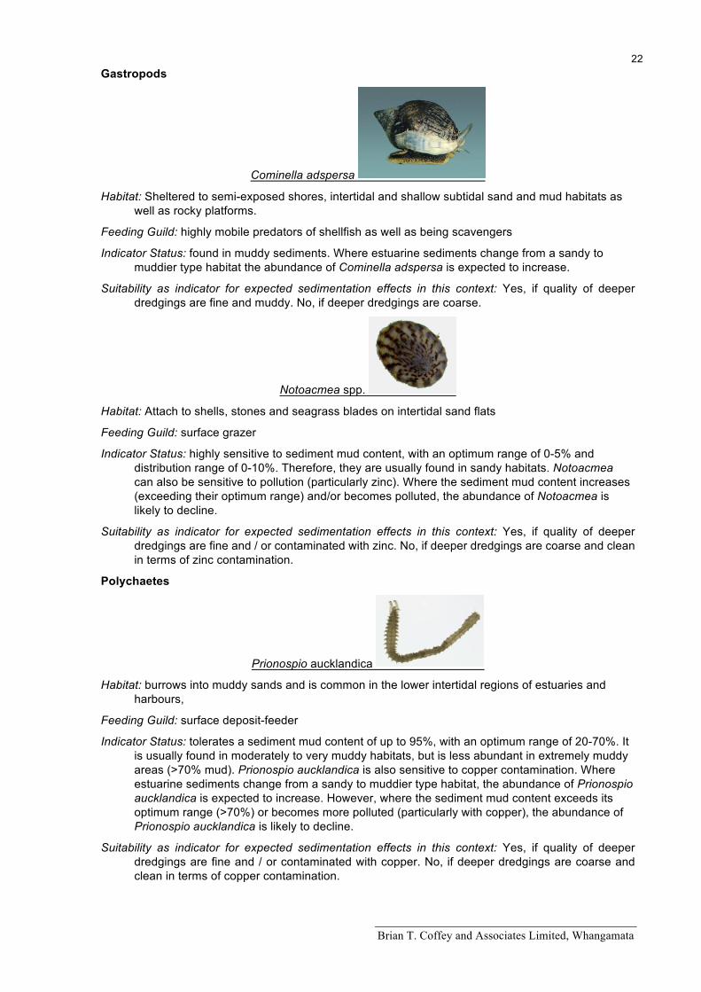
Cominella adspersa
Habitat: Sheltered to semi-exposed shores, intertidal and shallow subtidal sand and mud habitats as well as rocky platforms.
Feeding Guild: highly mobile predators of shellfish as well as being scavengers
Indicator Status: found in muddy sediments. Where estuarine sediments change from a sandy to muddier type habitat the abundance of Cominella adspersa is expected to increase.
Suitability as indicator for expected sedimentation effects in this context: Yes, if quality of deeper dredgings are fine and muddy. No, if deeper dredgings are coarse.
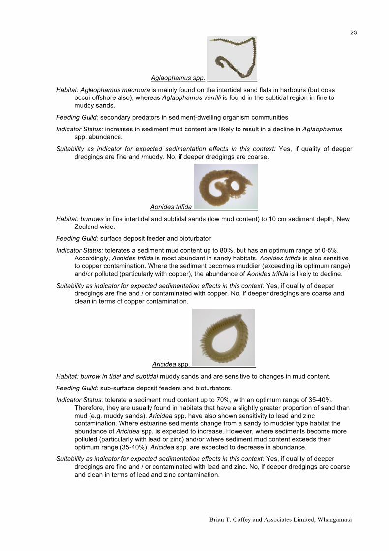
Notoacmea spp.
Habitat: Attach to shells, stones and seagrass blades on intertidal sand flats
Feeding Guild: surface grazer
Indicator Status: highly sensitive to sediment mud content, with an optimum range of 0-5% and distribution range of 0-10%. Therefore, they are usually found in sandy habitats. Notoacmea can also be sensitive to pollution (particularly zinc). Where the sediment mud content increases (exceeding their optimum range) and/or becomes polluted, the abundance of Notoacmea is likely to decline.
Suitability as indicator for expected sedimentation effects in this context: Yes, if quality of deeper dredgings are fine and / or contaminated with zinc. No, if deeper dredgings are coarse and clean in terms of zinc contamination.
Polychaetes
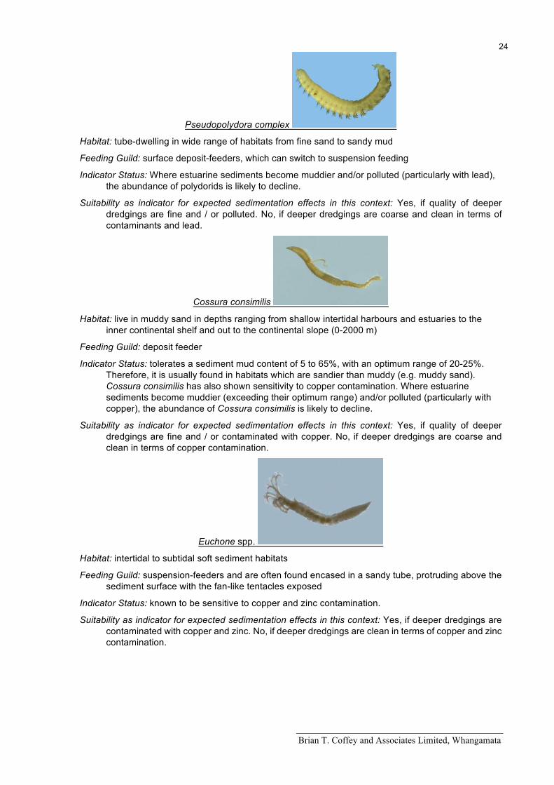
Prionospio aucklandica
Habitat: burrows into muddy sands and is common in the lower intertidal regions of estuaries and harbours,
Feeding Guild: surface deposit-feeder
Indicator Status: tolerates a sediment mud content of up to 95%, with an optimum range of 20-70%. It is usually found in moderately to very muddy habitats, but is less abundant in extremely muddy areas (>70% mud). Prionospio aucklandica is also sensitive to copper contamination. Where estuarine sediments change from a sandy to muddier type habitat, the abundance of Prionospio aucklandica is expected to increase. However, where the sediment mud content exceeds its optimum range (>70%) or becomes more polluted (particularly with copper), the abundance of Prionospio aucklandica is likely to decline.
Suitability as indicator for expected sedimentation effects in this context: Yes, if quality of deeper dredgings are fine and / or contaminated with copper. No, if deeper dredgings are coarse and clean in terms of copper contamination.
Brian T. Coffey and Associates Limited, Whangamata
23
Aglaophamus spp.
Habitat: Aglaophamus macroura is mainly found on the intertidal sand flats in harbours (but does occur offshore also), whereas Aglaophamus verrilli is found in the subtidal region in fine to muddy sands.
Feeding Guild: secondary predators in sediment-dwelling organism communities
Indicator Status: increases in sediment mud content are likely to result in a decline in Aglaophamus spp. abundance.
Suitability as indicator for expected sedimentation effects in this context: Yes, if quality of deeper dredgings are fine and /muddy. No, if deeper dredgings are coarse.
Aonides trifida
Habitat: burrows in fine intertidal and subtidal sands (low mud content) to 10 cm sediment depth, New Zealand wide.
Feeding Guild: surface deposit feeder and bioturbator
Indicator Status: tolerates a sediment mud content up to 80%, but has an optimum range of 0-5%. Accordingly, Aonides trifida is most abundant in sandy habitats. Aonides trifida is also sensitive to copper contamination. Where the sediment becomes muddier (exceeding its optimum range) and/or polluted (particularly with copper), the abundance of Aonides trifida is likely to decline.
Suitability as indicator for expected sedimentation effects in this context: Yes, if quality of deeper dredgings are fine and / or contaminated with copper. No, if deeper dredgings are coarse and clean in terms of copper contamination.
Aricidea spp.
Habitat: burrow in tidal and subtidal muddy sands and are sensitive to changes in mud content.
Feeding Guild: sub-surface deposit feeders and bioturbators.
Indicator Status: tolerate a sediment mud content up to 70%, with an optimum range of 35-40%. Therefore, they are usually found in habitats that have a slightly greater proportion of sand than mud (e.g. muddy sands). Aricidea spp. have also shown sensitivity to lead and zinc contamination. Where estuarine sediments change from a sandy to muddier type habitat the abundance of Aricidea spp. is expected to increase. However, where sediments become more polluted (particularly with lead or zinc) and/or where sediment mud content exceeds their optimum range (35-40%), Aricidea spp. are expected to decrease in abundance.
Suitability as indicator for expected sedimentation effects in this context: Yes, if quality of deeper dredgings are fine and / or contaminated with lead and zinc. No, if deeper dredgings are coarse and clean in terms of lead and zinc contamination.
Brian T. Coffey and Associates Limited, Whangamata
24
Pseudopolydora complex
Habitat: tube-dwelling in wide range of habitats from fine sand to sandy mud
Feeding Guild: surface deposit-feeders, which can switch to suspension feeding
Indicator Status: Where estuarine sediments become muddier and/or polluted (particularly with lead), the abundance of polydorids is likely to decline.
Suitability as indicator for expected sedimentation effects in this context: Yes, if quality of deeper dredgings are fine and / or polluted. No, if deeper dredgings are coarse and clean in terms of contaminants and lead.
Cossura consimilis
Habitat: live in muddy sand in depths ranging from shallow intertidal harbours and estuaries to the inner continental shelf and out to the continental slope (0-2000 m)
Feeding Guild: deposit feeder
Indicator Status: tolerates a sediment mud content of 5 to 65%, with an optimum range of 20-25%. Therefore, it is usually found in habitats which are sandier than muddy (e.g. muddy sand). Cossura consimilis has also shown sensitivity to copper contamination. Where estuarine sediments become muddier (exceeding their optimum range) and/or polluted (particularly with copper), the abundance of Cossura consimilis is likely to decline.
Suitability as indicator for expected sedimentation effects in this context: Yes, if quality of deeper dredgings are fine and / or contaminated with copper. No, if deeper dredgings are coarse and clean in terms of copper contamination.
Euchone spp.
Habitat: intertidal to subtidal soft sediment habitats
Feeding Guild: suspension-feeders and are often found encased in a sandy tube, protruding above the sediment surface with the fan-like tentacles exposed
Indicator Status: known to be sensitive to copper and zinc contamination.
Suitability as indicator for expected sedimentation effects in this context: Yes, if deeper dredgings are contaminated with copper and zinc. No, if deeper dredgings are clean in terms of copper and zinc contamination.
Brian T. Coffey and Associates Limited, Whangamata
25
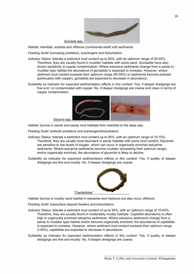
Goniada spp.
Habitat: intertidal, subtidal and offshore (continental shelf) soft sediments
Feeding Guild: burrowing predators, scavengers and bioturbators
Indicator Status: tolerate a sediment mud content up to 60%, with an optimum range of 50-55%. Therefore, they are usually found in muddier habitats with some sand. Goniadids have also shown sensitivity to copper contamination. Where estuarine sediments change from a sandy to muddier type habitat the abundance of goniadids is expected to increase. However, where sediment mud content exceeds their optimum range (50-55%) or sediments become polluted (particularly with copper), goniadids are expected to decrease in abundance.
Suitability as indicator for expected sedimentation effects in this context: Yes, if deeper dredgings are fine and / or contaminated with copper. No, if deeper dredgings are coarse and clean in terms of copper contamination.
Glycera spp.
Habitat: burrow in sands and sandy mud habitats from intertidal to the deep sea.
Feeding Guild: ambush predators and scavengers/bioturbators
Indicator Status: tolerate a sediment mud content up to 95%, with an optimum range of 10-15%. Therefore, they are usually most abundant in sandy habitats with some mud content. Glycerids are sensitive to low levels of oxygen, which can occur in organically enriched estuarine sediments. Where estuarine sediments become muddier (exceeding their optimum range) and/or organically enriched, the abundance of glycerids is likely to decline.
Suitability as indicator for expected sedimentation effects in this context: Yes, if quality of deeper dredgings are fine and muddy. No, if deeper dredgings are coarse.
“Capitellidae”
Habitat: burrow in muddy sand habitat in estuaries and harbours but also occur offshore.
Feeding Guild: subsurface deposit feeders and bioturbators
Indicator Status: tolerate a sediment mud content of up to 95%, with an optimum range of 10-40%. Therefore, they are usually found in moderately muddy habitats. Capitellid abundance is often high in organically enriched estuarine sediments. Where estuarine sediments change from a sandy to muddier type habitat and/or become organically enriched, the abundance of capitellids is expected to increase. However, where sediment mud content exceeds their optimum range (>40%), capitellids are expected to decrease in abundance.
Suitability as indicator for expected sedimentation effects in this context: Yes, if quality of deeper dredgings are fine and muddy. No, if deeper dredgings are coarse.
Brian T. Coffey and Associates Limited, Whangamata
26
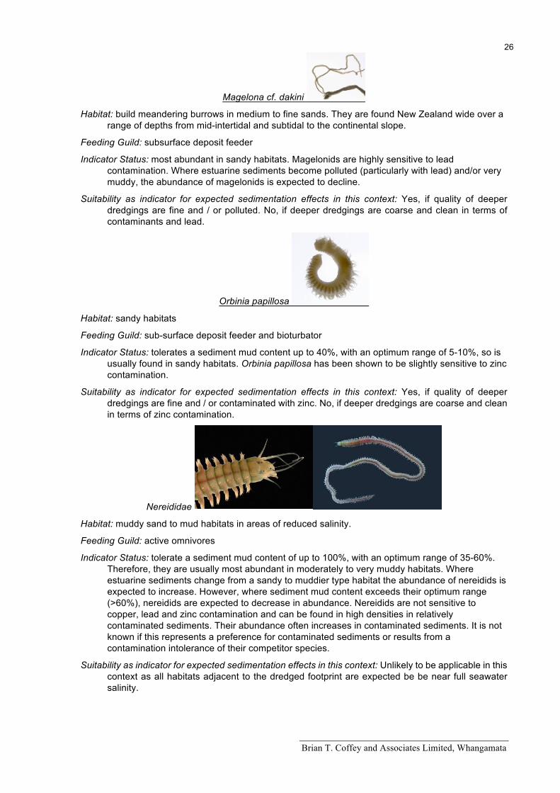
Magelona cf. dakini
Habitat: build meandering burrows in medium to fine sands. They are found New Zealand wide over a range of depths from mid-intertidal and subtidal to the continental slope.
Feeding Guild: subsurface deposit feeder
Indicator Status: most abundant in sandy habitats. Magelonids are highly sensitive to lead contamination. Where estuarine sediments become polluted (particularly with lead) and/or very muddy, the abundance of magelonids is expected to decline.
Suitability as indicator for expected sedimentation effects in this context: Yes, if quality of deeper dredgings are fine and / or polluted. No, if deeper dredgings are coarse and clean in terms of contaminants and lead.
Orbinia papillosa
Habitat: sandy habitats
Feeding Guild: sub-surface deposit feeder and bioturbator
Indicator Status: tolerates a sediment mud content up to 40%, with an optimum range of 5-10%, so is usually found in sandy habitats. Orbinia papillosa has been shown to be slightly sensitive to zinc contamination.
Suitability as indicator for expected sedimentation effects in this context: Yes, if quality of deeper dredgings are fine and / or contaminated with zinc. No, if deeper dredgings are coarse and clean in terms of zinc contamination.
Nereididae
Habitat: muddy sand to mud habitats in areas of reduced salinity.
Feeding Guild: active omnivores
Indicator Status: tolerate a sediment mud content of up to 100%, with an optimum range of 35-60%. Therefore, they are usually most abundant in moderately to very muddy habitats. Where estuarine sediments change from a sandy to muddier type habitat the abundance of nereidids is expected to increase. However, where sediment mud content exceeds their optimum range (>60%), nereidids are expected to decrease in abundance. Nereidids are not sensitive to copper, lead and zinc contamination and can be found in high densities in relatively contaminated sediments. Their abundance often increases in contaminated sediments. It is not known if this represents a preference for contaminated sediments or results from a contamination intolerance of their competitor species.
Suitability as indicator for expected sedimentation effects in this context: Unlikely to be applicable in this context as all habitats adjacent to the dredged footprint are expected be be near full seawater salinity.
Brian T. Coffey and Associates Limited, Whangamata
27
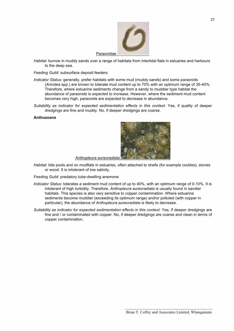
Paraonidae
Habitat: burrow in muddy sands over a range of habitats from intertidal flats in estuaries and harbours to the deep sea.
Feeding Guild: subsurface deposit feeders
Indicator Status: generally, prefer habitats with some mud (muddy sands) and some paraonids (Aricidea spp.) are known to tolerate mud content up to 70% with an optimum range of 35-40%. Therefore, where estuarine sediments change from a sandy to muddier type habitat the abundance of paraonids is expected to increase. However, where the sediment mud content becomes very high, paraonids are expected to decrease in abundance.
Suitability as indicator for expected sedimentation effects in this context: Yes, if quality of deeper dredgings are fine and muddy. No, if deeper dredgings are coarse.
Anthozoans
Anthopleura aureoradiata
Habitat: tide pools and on mudflats in estuaries, often attached to shells (for example cockles), stones or wood. It is intolerant of low salinity.
Feeding Guild: predatory tube-dwelling anemone
Indicator Status: tolerates a sediment mud content of up to 40%, with an optimum range of 0-10%. It is intolerant of high turbidity. Therefore, Anthopleura aureoradiata is usually found in sandier habitats. This species is also very sensitive to copper contamination. Where estuarine sediments become muddier (exceeding its optimum range) and/or polluted (with copper in particular), the abundance of Anthopleura aureoradiata is likely to decrease.
Suitability as indicator for expected sedimentation effects in this context: Yes, if deeper dredgings are fine and / or contaminated with copper. No, if deeper dredgings are coarse and clean in terms of copper contamination.