Water Quality Assessment Report Santa Ana River Trail ...
39
Water Quality Assessment Report Santa Ana River Trail Phase IV, Reaches B and C Project County of San Bernardino City of Redlands Caltrans District 8 Federal Project Number: ATPL-5954(146) September 2018
Transcript of Water Quality Assessment Report Santa Ana River Trail ...

Water Quality Assessment Report
Santa Ana River Trail Phase IV, Reaches B and C Project
County of San Bernardino
City of Redlands
Caltrans District 8
Federal Project Number: ATPL-5954(146)
September 2018
Water Quality Assessment Report
Santa Ana River Trail Phase IV, Reaches B and C Project
County of San Bernardino
City of Redlands
Caltrans District 8
08-SBd-0
Federal Project Number: ATPL-5954(146)
September 2018
STATE OF CALIFORNIA Department of Transportation
Prepared By: Ceazar Aguilar, P.E. Date: ____________
President
Office: (951) 300-1431 Fax: (951) 300-1435
Aguilar Consulting, Inc.
2155 Chicago Avenue, Suite 304, Riverside, CA 92508
___________________________________
Approved By: ___________________________________ Date: ____________
District Environmental Branch Chief
Phone Number
Office Name
District/Region
Pending Review and Approval by Caltrans
H5521
Draft

Executive Summary
i Santa Ana River Trail Phase IV, Reaches B and C Project
Executive Summary The County of San Bernardino Regional Parks Department (Regional Parks) with the assistance of the County of San Bernardino Department of Public Works (Department of Public Works) proposes to construct an approximately 3.3-mile-long section of the Santa Ana River Trail (SART) on the southern bank of the Santa Ana River and local streets within the City of Redlands. The SART is a regional recreational trail; segments of the trail within San Bernardino County have been constructed in various sections (phases) with projects named sequentially. The proposed section of the SART is SART Phase IV, Reaches B & C; the trail would begin on the west side of Orange Street in the City of Redlands and terminate at Opal Avenue near the Redlands city limits. East of Orange Street the conceptual trail alignment overlaps a local trail known as the “Bluffs trail.” At River Bend Drive, the alignment takes off from the river bluff and transitions on to the local city streets. The trail then travels south on River Bend Drive, east on Pioneer Avenue, south on Dearborn Street, and east on San Bernardino Avenue until the trail reaches Opal Avenue. The trail segments on the river bluffs would consist of a 10-foot wide asphalt/concrete trail and 4-foot decomposed granite/or 2-foot graded shoulder on each side of the asphalt/concrete trail. On the public right-of-way, the existing road surface would be widened were possible to accommodate a Class-II dedicated bicycle lane and/or Class-II standard bicycle lane where stripping would be used to mark the alignment on the existing road surfaces. Under the existing condition, portions of Pioneer Avenue and San Bernardino Avenue do not have a curb and gutter. Where possible, ultimate curb and gutter or asphalt dike would be constructed as part of this project. In general, construction activities associated with development of the trail would include: earthwork including excavation and grading; construction of embankments and/or retaining walls; construction of drainage structures, and slope protection; construction of asphalt concrete dike, curb and gutter; installation of fencing, railing, access gates, trail delineators, and signage; painting of pavement striping and pavement markings; and, construction of appurtenant features. The subject segment of the SART includes one bridge over Orange Street in the City of Redlands. Equipment staging and borrow/disposal during project construction may potentially occur at: (1) various locations within the disturbed vacant lands on the north side of Riverview Drive; (2) on disturbed road shoulders and/or street right-of-way on the south side of Pioneer Avenue; (3) at the Redlands Sports Park paved parking long; (4) on disturbed road shoulders and/or street right-of-way on the south side of San Bernardino Avenue; and, (5) on paved road shoulders and/or street right-of-way on the east side of Wabash Avenue. Additionally, portions of the proposed trail alignment overlap or are located in close proximity to USFWS designated critical habitat. SART Phase IV is included in the Upper Santa Ana Wash Land Management and Habitat Conservation Plan (Wash Plan). However, the Implementation Plan for the Wash Plan is currently being developed and final approvals from the regulatory agencies have not yet been secured; the status for implementation of the Wash Plan is not

Executive Summary
ii Santa Ana River Trail Phase IV, Reaches B and C Project
definitively known. Therefore, consultation with and USFWS is required to fulfill ESA requirements under Caltrans NEPA. The construction, use, operation, and maintenance of the proposed project have the potential to contribute pollutants to stormwater runoff from the Project. Because stormwater runoff from the Project may enter the Santa Ana River by direct discharge or by indirect discharge through the municipal separate storm drain system (MS4), measures to control, reduce, or eliminate the discharge of pollutants to the Project’s stormwater runoff are required. These pollutant control measures are known as Best Management Practices (BMPs) and are implemented in two distinct phases of the Project; (1) Construction Phase, and (2) Post-Construction Phase. The federal Clean Water Act and the California Porter-Cologne Water Quality Act implement the National Pollutant Discharge Elimination System (NPDES) program in California. The NPDES program controls water pollution by regulating sources that discharge pollutants to waters of the United States. The state program is administered by the California State Water Resources Control Board (SWRCB) and the California Regional Water Quality Control Boards (RWQCB). The SWRCB and RWQCB programs require the control of pollutants during construction and throughout the life of the Project. Locally, the City of Redlands holds an NPDES permit for discharges from its MS4 system. On January 29, 2010 the Santa Ana Regional Water Quality Control Board issued a fourth-term area wide National Pollutant Discharge Elimination System (NPDES) Municipal Separate Storm Sewer System Permit (MS4 Permit) to the San Bernardino Flood Control District (the Principal Permittee), the County of San Bernardino and the City of Redlands. The Santa Ana MS4 Permit is for the portion of the Santa Ana River watershed located within San Bernardino County (Order No. R8-2010-0036, NPDES Permit No. CAS618036). The Permittees’ storm water programs are designed to ensure compliance with this permit. Designated Critical Habitat (CH) for the San Bernardino kangaroo rat (Dipodomys merriami parvus) occurs north of the DA near the intersection of Sessums Avenue and Dearborn Street. CH for the Santa Ana sucker (Catostomus santaanae) occurs farther north from the DA in the Santa Ana River floodplain. No direct, adverse modification of critical habitat associated with the construction or operation of SART is anticipated. Potential effects on critical habitat and endangered species will be documented more thoroughly in a Natural Environment Study. A Biological Assessment will be prepared for formal consultation with the USFWS in accordance with Section 7 of the Endangered Species Act to document potential effects due to SART on threatened and endangered species and critical habitat. It has been determined that there are six (6) features within or directly adjacent to the project area that fall outside of the jurisdiction of the USACE and SWRCB pursuant to Section 404 and 401 of the Clean Water Act, respectively. These features consist of portions with the Santa Ana River, along with its floodplain, plus five unnamed features that connect with the river and are manmade, artificial stormwater conveyances. No USACE wetlands were found within the project area. Even though the CDFW has broader criteria for what constitutes a jurisdictional feature, the features mentioned above are considered to be outside of CDFW jurisdiction because of their limited habitat values and artificial nature.

Executive Summary
iii Santa Ana River Trail Phase IV, Reaches B and C Project
According to the impact map provided by the County, there would be no impacts to jurisdictional features associated with the SART Project. There will be no need for regulatory permitting for the SART Project as all impacts to jurisdictional features are avoided. Coordination with the USACE and other agencies is recommended to confirm these findings. The City of Redlands requires the Project to develop and implement two plans to control water pollution. The Storm Water Pollution Prevention Plan (SWPPP) will identify the potential pollutants associated with construction of the Project and the BMPs that will be implemented during construction to control, reduce, or eliminate these pollutants in discharges of stormwater runoff from the Project. The second plan is the Water Quality Management Plan (WQMP) that will identify the potential pollutants associated with the use, operation, and maintenance of the completed Project and the BMPs that will be incorporate into the Project to control, reduce, or eliminate these pollutants in discharges of stormwater runoff throughout the operational life of the Project. To efficiently and effectively comply with the City of Redlands requirements for water quality control, two documents are being prepared for this Project:
Storm Water Pollution Prevention Plan (SWPPP) – The SWPPP will include treatment BMPs to control the discharge of pollutants in stormwater runoff associated with the construction of the Project. The SWPPP will include a description of the construction phase BMPs identified for the Project. Some of the construction phase BMPs for the Project include:
o Scheduling o Streambank Stabilization o Wind Erosion Controls o Storm Drain Inlet Protection o Gravel Bag Berm o Gravel Bag Check Dams o Sediment Sweeping and Vacuuming o Material and Waste Handling and Storage
Water Quality Management Plan (WQMP) – The WQMP is a post-construction plan
for managing the quality and quantity of stormwater runoff that flows from the Project after construction is completed and the Project is operational. The WQMP will describe the site design, source control and treatment control Best Management Practices (BMPs) that will be implemented and maintained throughout the life of Project to prevent and minimize water pollution that can be caused by stormwater runoff. The WQMP includes the following three major categories of BMPs:
o Site Design BMPs (also known as Low Impact Development strategies) – are Project features that are designed or incorporated into a project to minimize the
Executive Summary
iv Santa Ana River Trail Phase IV, Reaches B and C Project
increase in stormwater runoff from the developed project site. Examples of Site Design BMPs include the use of porous pavement or pavers, minimizing the use of impervious pavement areas, directing roof drains to landscaped areas, disconnecting impervious areas, and conserving natural areas, etc., to allow water to percolate into the ground.
o Source Control BMPs – Activities or structures aimed at eliminating or minimizing contact between pollutant sources and stormwater/urban runoff. Examples of Source Control BMPs include education, contractor training, storm drain markings, sweeping, litter collection, canopies over fueling islands, and awnings or tarps to cover materials stored outdoors. These BMPs help keep water from carrying pollutants to storm drain systems and then to Santa Ana River.
o Treatment Control BMPs – Engineered devices or systems incorporated into the project’s drainage system to remove pollutants from stormwater runoff before the runoff leaves the project site. Examples of Treatment Control BMPs include vegetated swales, infiltration trenches, detention/retention basins, catch basin filters, and vortex separators. These devices help remove potential pollutants from stormwater runoff prior to leaving site and entering storm drain systems and then to Santa Ana River.
The Post-Construction BMPs for the Project may include: o Education for Property Owners o Drainage Facility Inspection and Maintenance o Street Sweeping o MS4 Stenciling and Signage o Channel and Slope Protection
Collectively, the BMPs described in the SWPPP and/or the WQMP are expected to mitigate the discharge of pollutants associated with the construction, use, operation, and maintenance of the Project to levels that are less than significant.

Table of Contents
v Santa Ana River Trail Phase IV, Reaches B and C Project
Table of Contents
EXECUTIVE SUMMARY ............................................................................................... i Table of Contents ............................................................................................................. vi List of Figures ................................................................................................................. viii List of Tables .................................................................................................................. viii List of Appendices .......................................................................................................... viii 1. INTRODUCTION........................................................................................................1
1.1 Approach to Water Quality Assessment ..............................................................1 1.2 Project Description ................................................................................................1
1.2.1 No Project Alternative ......................................................................................2 1.2.2 Alternative 1.......................................................................................................2
2. REGULATORY SETTING ........................................................................................7
2.1 Federal Laws and Requirements ..........................................................................7 2.2 State Laws and Requirements ..............................................................................8 2.3 Regional and Local Requirements .....................................................................10
3. AFFECTED ENVIRONMENT ................................................................................11
3.1 General Environmental Setting ..........................................................................11 3.1.1 Population and Land Use .................................................................................11 3.1.2 Topography ......................................................................................................11 3.1.3 Hydrology ........................................................................................................11
3.1.3.1 Regional Hydrology ......................................................................................11 3.1.3.2 Local Hydrology ...........................................................................................12
3.1.3.2.1 Precipitation and Climate .....................................................................12 3.1.3.2.2. Surface Streams ...................................................................................12 3.1.3.2.3 Floodplains ...........................................................................................13 3.1.3.2.4 Municipal Supply .................................................................................14
3.1.3.3 Groundwater Hydrology ............................................................................14 3.1.4 Geology/Soils ...................................................................................................14 3.1.5 Biological Communities ..................................................................................15
3.1.5.1 Aquatic Habitat ..........................................................................................15 4. ENVIRONMENTAL CONSEQUENCES ...............................................................16
4.1 Introduction ..........................................................................................................16 4.2 Potential Impacts to Water Quality ...................................................................16
4.2.1 Anticipated Changes to the Physical/Chemical Characteristics of the Aquatic Environment .....................................................................................................16
4.2.1.1 Substrate .....................................................................................................16 4.2.1.2 Currents, Circulation or Drainage Patterns ................................................16 4.2.1.3 Suspended Particulates (Turbidity) ............................................................16 4.2.1.4 Oil, Grease and Chemical Pollutants .........................................................16
Table of Contents
vi Santa Ana River Trail Phase IV, Reaches B and C Project
4.2.1.5 Temperature, Oxygen Depletion and Other Parameters ............................16 4.2.1.6 Flood Control Functions ............................................................................16 4.2.1.7 Storm, Wave and Erosion Buffers .............................................................16 4.2.1.8 Erosion and Accretion Patterns ..................................................................16 4.2.1.9 Aquifer Recharge/Groundwater .................................................................16 4.2.1.10 Baseflow ....................................................................................................16
4.2.2 Anticipated Changes to the Biological Characteristics of the Aquatic Environment .....................................................................................................17 4.2.3 Anticipated Changes to the Human Use Characteristics of the Aquatic Environment .....................................................................................................17
4.2.3.1 Existing and Potential Water Supplies; Water Conservation ....................17 4.2.3.2 Recreational or Commercial Fisheries .......................................................17 4.2.3.3 Other Water Related Recreation ................................................................17 4.2.3.4 Aesthetics of the Aquatic Ecosystem .........................................................17 4.2.3.5 Parks, National and Historical Monuments, National Seashores, Wild and Scenic Rivers, Wilderness Areas, etc. .......................................................17 4.2.3.6 Traffic/Transportation Patterns ..................................................................17 4.2.3.7 Energy Consumption or Generation ..........................................................17 4.2.3.8 Navigation ..................................................................................................18 4.2.3.9 Safety .........................................................................................................18
4.2.4 Temporary Impacts to Water Quality ..............................................................18 4.2.4.1 No Build Alternative ..................................................................................18 4.2.4.2 Build Alternative(s) ...................................................................................18
4.2.5 Long-Term Impacts During Operation and Maintenance ................................18 4.2.5.1 No Build Alternative ..................................................................................18 4.2.5.2 Build Alternative(s) ...................................................................................18
4.3 Impact Assessment Methodology .......................................................................19 4.4 Cumulative Impacts .............................................................................................19
5. AVOIDANCE AND MINIMIZATION MEASURES ............................................20 6. REFERENCES ...........................................................................................................21
6.1 Works Cited ..........................................................................................................22 6.2 Preparer(s) Qualifications ...................................................................................22
List of Figures
Figure 1 Project Location ..................................................................................................1
List of Appendices
Appendix A: Risk Assessment
List of Exhibits
Exhibit A: Regional Location Map

Table of Contents
vii Santa Ana River Trail Phase IV, Reaches B and C Project
Exhibit B: Project Vicinity Map Exhibit C: Project Location Map Exhibit D: County of San Bernardino Department of Public Works – Transportation Plans
for Construction on Santa Ana River Trail (SART) Phase IV, Reaches B and C
1. Introduction
Santa Ana River Trail Phase IV, Reaches B and C Project
1. INTRODUCTION
1.1 Approach to Water Quality Assessment
The purpose of the Water Quality Assessment Report (WQAR) is to fulfill the requirements of the National Environmental Policy Act (NEPA) and the California Environmental Quality Act (CEQA), and to provide information for National Pollutant Discharge Elimination System (NPDES) permitting. The document includes a discussion of the proposed project, the general environmental setting of the project area, and the regulatory framework with respect to water quality; it also provides data on surface water and groundwater resources within the project area and the water quality of these waters, describes water quality impairments and beneficial uses, and identifies potential water quality impacts/benefits associated with the proposed project, and recommends avoidance and/or minimization measures for potentially adverse impacts. 1.2 Project Description
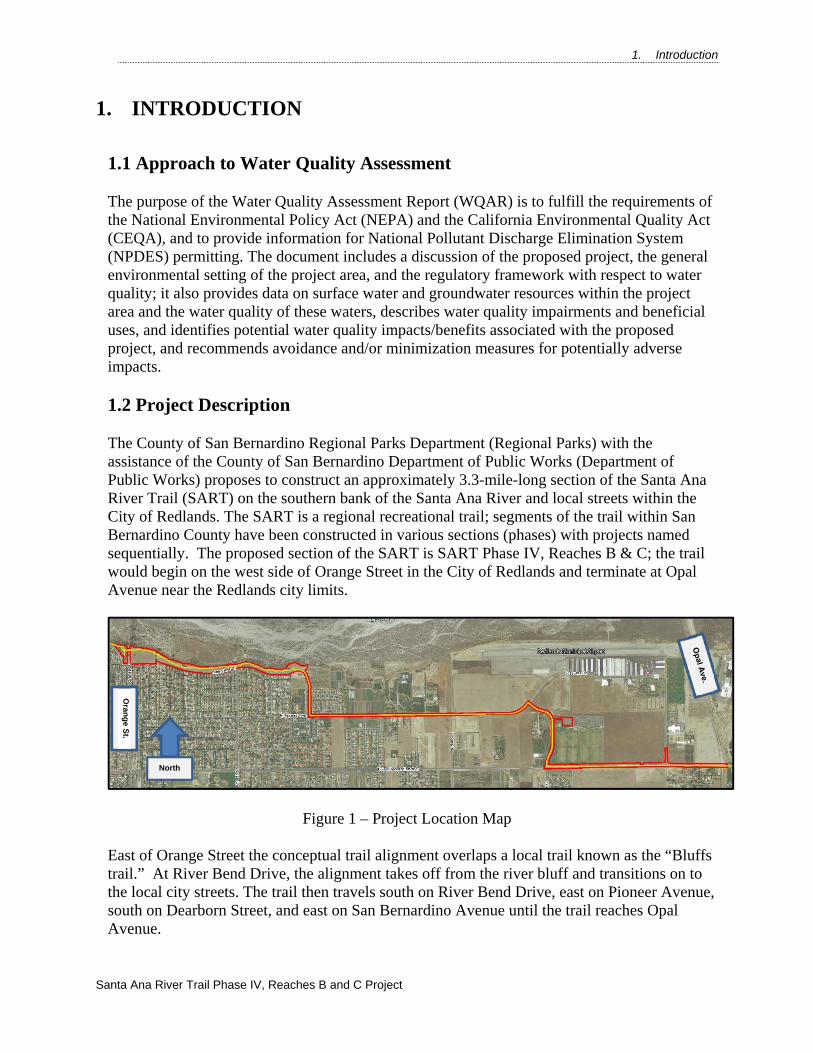
The County of San Bernardino Regional Parks Department (Regional Parks) with the assistance of the County of San Bernardino Department of Public Works (Department of Public Works) proposes to construct an approximately 3.3-mile-long section of the Santa Ana River Trail (SART) on the southern bank of the Santa Ana River and local streets within the City of Redlands. The SART is a regional recreational trail; segments of the trail within San Bernardino County have been constructed in various sections (phases) with projects named sequentially. The proposed section of the SART is SART Phase IV, Reaches B & C; the trail would begin on the west side of Orange Street in the City of Redlands and terminate at Opal Avenue near the Redlands city limits.
Figure 1 – Project Location Map East of Orange Street the conceptual trail alignment overlaps a local trail known as the “Bluffs trail.” At River Bend Drive, the alignment takes off from the river bluff and transitions on to the local city streets. The trail then travels south on River Bend Drive, east on Pioneer Avenue, south on Dearborn Street, and east on San Bernardino Avenue until the trail reaches Opal Avenue.
North
Oran
ge S
t.

1. Introduction
Santa Ana River Trail Phase IV, Reaches B and C Project
The trail segments on the river bluffs would consist of a 10-foot wide asphalt/concrete trail and 4-foot decomposed granite/or 2-foot graded shoulder on each side of the asphalt/concrete trail. On the public right-of-way, the existing road surface would be widened were possible to accommodate a Class-II dedicated bicycle lane and/or Class-II standard bicycle lane where stripping would be used to mark the alignment on the existing road surfaces. Under the existing condition, portions of Pioneer Avenue and San Bernardino Avenue do not have a curb and gutter. Where possible, ultimate curb and gutter or asphalt dike would be constructed as part of this project. In general, construction activities associated with development of the trail would include: earthwork including excavation and grading; construction of embankments and/or retaining walls; construction of drainage structures, and slope protection; construction of asphalt concrete dike, curb and gutter; installation of fencing, railing, access gates, trail delineators, and signage; painting of pavement striping and pavement markings; and, construction of appurtenant features. The subject segment of the SART includes one bridge over Orange Street in the City of Redlands. Equipment staging and borrow/disposal during project construction may potentially occur at: (1) various locations within the disturbed vacant lands on the north side of Riverview Drive; (2) on disturbed road shoulders and/or street right-of-way on the south side of Pioneer Avenue; (3) at the Redlands Sports Park paved parking long; (4) on disturbed road shoulders and/or street right-of-way on the south side of San Bernardino Avenue; and, (5) on paved road shoulders and/or street right-of-way on the east side of Wabash Avenue.
A Risk Level Assessment was performed. From its findings, the Project has a low sediment risk, low receiving waters risk, leading to the combined risk of the Project to be a Level 1.
1.2.1 No Project Alternative
Under this alternative, the existing mixture of developed and undeveloped lands within the project limits with no trails or associated improvements will remain.
1.2.2 Alternative 1
Alternative 1 (SART Phase IV, Reaches B & C) would construct the project starting just west of Orange Street to the east through the City of Redlands, for a distance of approximately 3.3 miles..

2. Regulatory Setting
Santa Ana River Trail Phase IV, Reaches B and C Project
2. Regulatory Setting
2.1 Federal Laws and Requirements
Clean Water Act
In 1972 Congress amended the Federal Water Pollution Control Act, making the addition of pollutants to the waters of the United States (U.S.) from any point source unlawful unless the discharge is in compliance with a NPDES permit. Known today as the Clean Water Act (CWA), Congress has amended it several times. In the 1987 amendments, Congress directed dischargers of stormwater from municipal and industrial/construction point sources to comply with the NPDES permit program. Important CWA sections are:
Sections 303 and 304 require states to promulgate water quality standards, criteria, and guidelines.
Section 401 requires an applicant for a federal license or permit to conduct any activity, which may result in a discharge to waters of the U.S., to obtain certification from the State that the discharge will comply with other provisions of the act. (Most frequently required in tandem with a Section 404 permit request. See below).
Section 402 establishes the NPDES, a permitting system for the discharges (except for dredge or fill material) of any pollutant into waters of the U.S. The Federal Environmental Protection Agency delegated to the California State Water Resources Control Board (SWRCB) the implementation and administration of the NPDES program in California. The SWRCB established nine Regional Water Quality Control Boards (RWQCBs). The SWRCB enacts and enforces the Federal NPDES program and all water quality programs and regulations that cross Regional boundaries. The nine RWQCBs enact, administer and enforce all programs, including NPDES permitting, within their jurisdictional boundaries. Section 402(p) requires permits for discharges of stormwater from industrial, construction, and Municipal Separate Storm Sewer Systems (MS4s).
Section 404 establishes a permit program for the discharge of dredge or fill material into waters of the U.S, including wetlands. This permit program is administered by the U.S. Army Corps of Engineers (USACE).
The objective of the CWA is “to restore and maintain the chemical, physical, and biological integrity of the Nation’s waters.”
The USACE issues two types of 404 permits: General and Individual. There are two types of General permits: Regional and Nationwide permits. Regional permits are issued for a general category of activities when they are similar in nature and cause minimal environmental effect. Nationwide permits are issued to authorize a variety of minor project activities with no more than minimal effects.
There are also two types of Individual permits: Standard Individual permit and Letter of Permission. Ordinarily, projects that do not meet the criteria for a Nationwide Permit may be permitted under one of USACE’s Individual permits. For Standard Individual permit, the
2. Regulatory Setting
Santa Ana River Trail Phase IV, Reaches B and C Project
USACE decision to approve is based on compliance with U.S. Environmental Protection Agency’s (EPA) Section 404 (b)(1) Guidelines (U.S. EPA CFR 40 Part 230), and whether permit approval is in the public interest. The 404(b)(1) Guidelines were developed by the U.S. EPA in conjunction with USACE, and allow the discharge of dredged or fill material into the aquatic system (waters of the U.S.) only if there is no practicable alternative which would have less adverse effects. The Guidelines state that USACE may not issue a permit if there is a least environmentally damaging practicable alternative (LEDPA), to the proposed discharge that would have less effects on waters of the U.S., and not have any other significant adverse environmental consequences. Per Guidelines, documentation is needed that a sequence of avoidance, minimization, and compensation measures have been followed, in that order. The Guidelines also restrict permitting activities that violate water quality or toxic effluent standards, jeopardize the continued existence of listed species, violate marine sanctuary protections, or cause “significant degradation” to waters of the U.S. In addition, every permit from the USACE, even if not subject to the 404(b)(1) Guidelines, must meet general requirements. See 33 CFR 320.4.
2.2 State Laws and Requirements
Porter-Cologne Water Quality Control Act
California’s Porter-Cologne Act, enacted in 1969, provides the legal basis for water quality regulation within California. This Act requires a “Report of Waste Discharge” for any discharge of waste (liquid, solid, or gaseous) to land or surface waters that may impair beneficial uses for surface and/or groundwater of the State. It predates the CWA and regulates discharges to waters of the State. Waters of the State include more than just waters of the U.S., like groundwater and surface waters not considered waters of the U.S. Additionally, it prohibits discharges of “waste” as defined and this definition is broader than the CWA definition of “pollutant”. Discharges under the Porter-Cologne Act are permitted by Waste Discharge Requirements (WDRs) and may be required even when the discharge is already permitted or exempt under the CWA.
The State Water Resources Control Board (SWRCB) and RWQCBs are responsible for establishing the water quality standards as required by the CWA, and regulating discharges to protect beneficial uses of water bodies. Details regarding water quality standards in a project area are contained in the applicable RWQCB Basin Plan. In California, Regional Boards designate beneficial uses for all water body segments in their jurisdictions, and then set standards necessary to protect these uses. Consequently, the water quality standards developed for particular water body segments are based on the designated use and vary depending on such use. Water body segments that fail to meet standards for specific pollutants are included in a Statewide List in accordance with CWA Section 303(d). If a Regional Board determines that waters are impaired for one or more constituents and the standards cannot be met through point source or non-source point controls (NPDES permits or Waste Discharge Requirements), the CWA requires the establishment of Total Maximum Daily Loads (TMDLs). TMDLs specify allowable pollutant loads from all sources (point, non-point, and natural) for a given watershed. The SWRCB implemented the requirements of CWA Section 303(d) through Attachment III of the County of San Bernardino Statewide MS4, as it includes specific TMDLs for which San Bernardino County and the City of Redlands are the named stakeholders.

2. Regulatory Setting
Santa Ana River Trail Phase IV, Reaches B and C Project
State Water Resources Control Board and Regional Water Quality Control Boards The SWRCB adjudicates water rights, sets water pollution control policy, and issues water board orders on matters of statewide application, and oversees water quality functions throughout the state by approving Basin Plans, TMDLs, and NPDES permits. RWCQBs are responsible for protecting beneficial uses of water resources within their regional jurisdiction using planning, permitting, and enforcement authorities to meet this responsibility.
National Pollutant Discharge Elimination System (NPDES) Program
Municipal Separate Storm Sewer Systems (MS4) Section 402(p) of the CWA requires the issuance of NPDES permits for five categories of stormwater dischargers, including MS4s. The U.S. EPA defines an MS4 as “any conveyance or system of conveyances (roads with drainage systems, municipal streets, catch basins, curbs, gutters, ditches, human-made channels, and storm drains) owned or operated by a state, city, town, county, or other public body having jurisdiction over storm water, that are designed or used for collecting or conveying stormwater.” The SWRCB has identified County of San Bernardino and the City of Redlands as the owner/operators of the MS4 pursuant to federal regulations. The County of San Bernardino’s and City of Redlands MS4 permit covers all County of San Bernardino and City of Redlands rights-of-way, properties, facilities, and activities in the state. The SWRCB or the RWQCB issues NPDES permits for five years, and permit requirements remain active until a new permit has been adopted.
Construction General Permit Construction General Permit (NPDES No. CAS000002, SWRCB Order No. 2009-0009-DWQ, adopted on November 16, 2010) became effective on February 14, 2011 and was amended by Order No. 2010-0014-DWQ and Order No. 2012-0006-DWQ. The permit regulates stormwater discharges from construction sites which result in a Disturbed Soil Area (DSA) of one acre or greater, and/or are smaller sites that are part of a larger common plan of development.
For all projects subject to the CGP, the applicant is required to hire a Qualified Storm Water Pollution Prevention Plan (SWPPP) Developer (QSD) to develop and implement an effective SWPPP. All Project Registration Documents, including the SWPPP, are required to be uploaded into the SWRCB’s on-line Stormwater Multiple Application and Report Tracking System (SMARTS), at least 30 days prior to construction.
Waivers from CGP coverage.
Projects that disturb over 1.0 acre but less than 5 acres of soil, may qualify for waiver of CGP coverage. This occurs whenever the R factor of the Watershed Erosion Estimate (=RxKxLS) in tons/acre is less than 5. Within this CGP formula, there is a factor related to when and where the construction will take place. This factor, the ‘R’ factor, may be low, medium or high. When the R factor is below the numeric value of 5, projects can be waived from coverage under the CGP, and are instead covered by the Caltrans Statewide MS4.
In accordance with SWMP, a Water Pollution Control Plan (WPCP) is necessary for construction of a Caltrans project not covered by the CGP.
2. Regulatory Setting
Santa Ana River Trail Phase IV, Reaches B and C Project
Construction activity that results in soil disturbances of less than one acre is subject to this CGP if there is potential for significant water quality impairment resulting from the activity as determined by the RWQCB. Operators of regulated construction sites are required to develop a SWPPP, to implement soil erosion and pollution prevention control measures, and to obtain coverage under the CGP.
The CGP contains a risk-based permitting approach by establishing three levels of risk possible for a construction site. Risk levels are determined during the planning, design, and construction phases, and are based on project risk of generating sediments and receiving water risk of becoming impaired. Requirements apply according to the Risk Level determined. For example, a Risk Level 3 (highest risk) project would require compulsory stormwater runoff pH and turbidity monitoring, and pre- and post-construction aquatic biological assessments during specified seasonal windows. Section 401 Permitting Under Section 401 of the CWA, any project requiring a federal license or permit that may result in a discharge to a water of the United States must obtain a 401 Certification, which certifies that the project will be in compliance with State water quality standards. The most common federal permit triggering 401 Certification is a CWA Section 404 permit, issued by USACE. The 401 permit certifications are obtained from the appropriate RWQCB, dependent on the project location, and are required before USACE issues a 404 permit. In some cases the RWQCB may have specific concerns with discharges associated with a project. As a result, the RWQCB may prescribe a set of requirements known as Waste Discharge Requirements (WDRs) under the State Water Code (Porter-Cologne Act). WDRs may specify the inclusion of additional project features, effluent limitations, monitoring, and plan submittals that are to be implemented for protecting or benefiting water quality. WDRs can be issued to address both permanent and temporary discharges of a project.
2.3 Regional and Local Requirements Locally, the City of Redlands holds an NPDES permit for discharges from its MS4 system. On January 29, 2010 the Santa Ana Regional Water Quality Control Board issued a fourth-term area wide National Pollutant Discharge Elimination System (NPDES) Municipal Separate Storm Sewer System Permit (MS4 Permit) to the San Bernardino Flood Control District (the Principal Permittee), the County of San Bernardino and the City of Redlands. The Santa Ana MS4 Permit is for the portion of the Santa Ana River watershed located within San Bernardino County (Order No. R8-2010-0036, NPDES Permit No. CAS618036). The Permittees’ storm water programs are designed to ensure compliance with this permit. See Section 2.2 for relevant requirements of the Construction General Permit and the City of Redlands NPDES/MS4 Program.

3. Affected Environment
Santa Ana River Trail Phase IV, Reaches B and C Project
3. AFFECTED ENVIRONMENT 3.1 General Environmental Setting
3.1.1 Population and Land Use The land uses within the project are predominantly composed of undeveloped bluffs adjacent to the Santa Ana River floodplain, but there are smaller components of urban and other developed uses, with specific uses being primarily residential properties. The Redlands Municipal Airport is located south of the project area in the eastern portion. As recently as 50 years ago, most of the project area was a mixture of undeveloped areas and orchards. Flood control channels for the residential areas were constructed in the intervening time. Adjacent land uses in the vicinity of the SART Project include undeveloped lands within the Santa Ana River, the Redlands Municipal Airport, residential uses, a school, and a gravel extraction facility east of Opal Avenue.
3.1.2 Topography The Project area is located within the Santa Ana River Watershed and on the bluffs adjacent to the south side of the river. The watershed is approximately 3,000 square miles and all drainage features within the project area drain to the Santa Ana River. Topography is generally flat to gently rolling. Just to the north of the project area, the bluffs drop down into the floodplain proper. The elevations range from approximately 1,322 feet above mean sea level (msl) in the west to 1,561 feet above msl in the east. 3.1.3 Hydrology
3.1.3.1 Regional Hydrology The project site is located in the Santa Ana River Watershed. The Santa Ana River watershed is located in southern California, south and east of the city of Los Angeles. The watershed includes much of Orange County, the northwestern corner of Riverside County, the southwestern corner of San Bernardino County, and a small portion of Los Angeles County. The watershed is generally bounded on the south by the Santa Margarita watershed, on the east by the Salton Sea and Southern Mojave watersheds, and on the north/west by the Mojave and San Gabriel watersheds. The watershed is approximately 2,650 square miles in area. The headwaters of the Santa Ana River are in the San Bernardino Mountains with two of its major tributaries Bear Creek and Mill Creek. Other tributaries include Lytle Creek originating in the San Gabriel Mountains and the San Jacinto River originating in the San Jacinto Mountains. These major tributaries confluence to form the Santa Ana River in the San Bernardino Valley located at the southern base of the Transverse Ranges of the San Bernardino Mountains. The Santa Ana River traverses through the San Bernardino Valley

3. Affected Environment
Santa Ana River Trail Phase IV, Reaches B and C Project
before cutting through the Santa Ana Mountains and flowing to the Orange Coastal Plain. Eventually the river discharges to the ocean in the City of Huntington Beach.
3.1.3.2 Local Hydrology
3.1.3.2.1 Precipitation and Climate The City of Redlands gets approximately 12 inches of rain per year. The US average is 39. Snowfall is 0 inches. The average US city gets 26 inches of snow per year. The number of days with any measurable precipitation is 22. On average, there are 279 sunny days per year in the City of Redlands, California. The July high is 94 degrees. The January low is 42 degrees. Comfort index, which is based on humidity during the hot months, is 86 out of 100, where higher is more comfortable. The US average on the comfort index is 54.
3.1.3.2.2 Surface Waters A beneficial use is one of the various ways that water can be used for the benefit of people and/or wildlife. Examples include drinking, swimming, industrial and agricultural water supply, and the support of fresh and saline aquatic habitats.
Section 303(d) of the federal Clean Water Act (33 U.S.C. § 1313) defines water quality standards as consisting of the uses of the surface (navigable) waters involved, the water quality criteria which are applied to protect those uses and an anti-degradation policy. Under the Porter-Cologne Water Quality Control Act (California Water Code, Division 7, Chapter 2 § 13050) the uses of waters and water quality criteria are separately considered as beneficial uses and water quality objectives. Beneficial uses and water quality objectives are to be established for all waters of the state, both surface and subsurface (groundwater). The Project discharges to Santa Ana River. According to the Santa Ana Region Basin Plan, Santa Ana River have the following beneficial uses: Santa Ana River Reach 3 – Prado Dam to Mission Blvd in Riverside MUN (Municipal and Domestic Supply) AGR (Agricultural Supply) GWR (Groundwater Recharge) REC1 (Water Contact Recreation) REC2 (Noncontact Water Recreation) WARM (Warm Freshwater Habitat) WILD (Wildlife Habitat) RARE (Rare, Threatened, or Endangered Species) SPWN (Spawning, Reproduction, and Development)
3. Affected Environment
Santa Ana River Trail Phase IV, Reaches B and C Project
Santa Ana River Reach 4 – Mission Blvd in Riverside to San Jacinto Fault in San Bernardino MUN (Municipal and Domestic Supply) GWR (Groundwater Recharge) REC1 (Water Contact Recreation) REC2 (Noncontact Water Recreation) WARM (Warm Freshwater Habitat) WILD (Wildlife Habitat) RARE (Rare, Threatened, or Endangered Species) Santa Ana River Reach 5 – San Jacinto Fault in San Bernardino to Seven Oaks Dam MUN (Municipal and Domestic Supply) AGR (Agricultural Supply) GWR (Groundwater Recharge) REC1 (Water Contact Recreation) REC2 (Noncontact Water Recreation) WARM (Warm Freshwater Habitat) WILD (Wildlife Habitat) RARE (Rare, Threatened, or Endangered Species)
3.1.3.2.3 Floodplains Review of the Federal Emergency Management Agency (FEMA) Flood Insurance Rate Maps (FIRM) No. 06071C8708H, dated August 28, 2008 and No. 06071C8709J, dated September 2, 2016 indicates that the alignment of the Project is located outside of the 100-year floodplain.
3.1.3.2.4 Municipal Supply San Bernardino Valley Municipal Water District (SBMWD) is the main water purveyor for the City of Redlands. SBMWD’s water supply is a blend of local groundwater, surface water, and recycled water. In 2015, the average the annual water production was about 347,371 acre-feet.
3.1.3.3 Groundwater Hydrology
The EDR Well Search Report reported groundwater levels ranging from approximately 170 feet below ground surface to 230 feet below ground surface. However, groundwater near the Santa Ana River Wash is anticipated to be shallower due to groundwater recharge from the river. The project is located within the Bunker Hill-Subbasin, which is a part of the Upper Santa Ana Valley Basin. Bunker Hill Subbasin is the largest subbasin in the Upper Santa Ana River watershed. The basin is bordered on the northwest by the San Gabriel Mountains and Cucamonga fault zone; on the northeast by the San Bernardino Mountains and San Andreas

3. Affected Environment
Santa Ana River Trail Phase IV, Reaches B and C Project
Fault zone; on the east by the Banning fault and Crafton Hills; and on the south by a low, east-facing escarpment of the San Jacinto fault and the San Timoteo Badlands. The Bunk Hill Sub Basin has a groundwater storage capacity of 5,976 acre-feet.
3.1.4 Geology/Soils
The Site is located in the San Bernardino Valley, bounded by the San Bernardino Mountains to the north, the San Gabriel Mountains to the northwest, and the hills of the Peninsular Ranges to the south and east. The Site sits on unconsolidated Holocene and Pleistocene age alluvial deposits of sand, gravel, silt, and clay that fill the Bunker Hill Subbasin. The southern boundary of the Bunker Hill Subbasin is the Banning fault, the eastern boundary is the Redlands fault, the northern boundary is the San Andreas Fault, the Glen Helen fault borders to the northwest, and the San Jacinto fault borders to the southwest. The Santa Ana River, Mill Creek, and Lytle Creek are the main tributary streams in the subbasin. Course sand and gravel alluvium is exposed in the Santa Ana River channels which flows west to southwest in the area of the Site. These alluvial deposits consist of unconsolidated sands and silty sands derived primarily from crystalline source rock in the San Bernardino Mountains. The sands and silty sands contain variable quantities of gravels, cobbles, and boulders. The water-bearing material has been divided into upper and lower aquifers. In the central part of the subbasin, a poorly permeable clay layer separates the aquifers, creating confined conditions in the lower aquifer under portions of the San Bernardino Valley. Maximum thickness of the upper aquifer is approximately 350 feet, and maximum thickness of the lower aquifer is approximately 650 feet. Groundwater generally converges toward the Santa Ana River in the southwestern part of the subbasin and discharges over the San Jacinto fault at the Colton Narrows.
3.1.5 Biological Communities
3.1.5.1 Aquatic Habitat Not applicable; there are no aquatic habitats within the project limits.

4. Environmental Consequences
Santa Ana River Trail Phase IV, Reaches B and C Project
4. ENVIRONMENTAL CONSEQUENCES
4.1 Introduction
Due to the nature of the project being for pedestrians and non-motorized transportation, the project will have minimal adverse effect on stormwater quality associated with the construction of the new pedestrian bridge and trails. As such, both during-construction and post-construction, BMPs will be installed and maintained to ensure local and regional stormwater quality is controlled and improved.
4.2 Potential Impacts to Water Quality
4.2.1 Anticipated changes to the Physical/Chemical Characteristics of the Aquatic
Environment
4.2.1.1 Substrate Not applicable. 4.2.1.2 Currents, Circulation or Drainage Patterns
The proposed project will not affect current drainage patterns.
4.2.1.3 Suspended Particulates (Turbidity) Not applicable. 4.2.1.4 Oil, Grease and Chemical Pollutants
Oil, grease, and chemical pollutants are generally considered to be common on project sites that accommodate pedestrian and non-vehicular traffic.
4.2.1.5 Temperature, Oxygen, Depletion and Other Parameters
Not applicable. However, trash is always present at any time of project type, regardless of the land use.
4.2.1.6 Flood Control Functions Not applicable. 4.2.1.7 Storm, Wave and Erosion Buffers
Not applicable.

4. Environmental Consequences
Santa Ana River Trail Phase IV, Reaches B and C Project
4.2.1.8 Erosion and Accretion Patterns The surrounding area of the Project site is relatively flat and is pervious. Potential for erosion and accretion due to the construction of the Project is unlikely and negligible.
4.2.1.9 Aquifer Recharge/Groundwater The Project will not affect the existing conditions of the groundwater table nor have any adverse effect on aquifer recharge. 4.2.1.10 Baseflow Baseflow will not be altered due to construction of the Project.
4.2.2 Anticipated Changes to the Biological Characteristics of the Aquatic Environment
Not applicable; there are no aquatic habitats within the project limits.
4.2.3 Anticipated Changes to the Human Use Characteristics of the Aquatic Environment
4.2.3.1 Existing and Potential Water Supplies; Water Conservation There are no impacts to the existing and potential water supplies.
4.2.3.2 Recreational or Commercial Fisheries Not applicable. 4.2.3.3 Other Water Related Recreation Not applicable. 4.2.3.4 Aesthetics of the Aquatic Ecosystem Not applicable. 4.2.3.5 Parks, National and Historic Monuments, National Seashores, Wild and Scenic
Rivers, Wilderness Areas, etc. Not applicable. 4.2.3.6 Traffic/Transportation Patterns Not applicable.

4. Environmental Consequences
Santa Ana River Trail Phase IV, Reaches B and C Project
4.2.3.7 Energy Consumption of Generation Not applicable. 4.2.3.8 Navigation Not applicable. 4.2.3.9 Safety With the construction of the proposed trail and the pedestrian bridge over Orange Street, pedestrians and bikers will have a safe way to cross and travel along the Santa Ana River Trail without having to share the road with motorized vehicles.
4.2.4 Temporary Impacts to Water Quality
4.2.4.1 No Build Alternative Under this alternative, no improvements would be made and thus would not affect existing water quality conditions.
4.2.4.2 Build Alternative(s) Runoff generated by the project will be treated by implementing Best Management Practices to ensure local and regional stormwater quality is not impacted, per the project WQMP.
4.2.5 Long-term Impacts During Operation and Maintenance
4.2.5.1 No Build Alternative Under this alternative, no improvements would be made and thus there would not be any long-term impacts to water quality.
4.2.5.2 Build Alternative(s) Due to the nature of the project being geared towards non-motorized transportation, there are no long-term impacts to water quality. However, Post Construction Best Management Practices such as a vegetated drainage swale along the length of the path will be installed and maintained to ensure local and regional stormwater quality is not impacted.
4.3 Impact Assessment Methodology The proposed project will pose the same potential pollutants in the during-construction phase, as well as the post-construction phase, as mentioned in the aforementioned sections.

4. Environmental Consequences
Santa Ana River Trail Phase IV, Reaches B and C Project
4.4 Cumulative Impacts There will be minimal addition of impervious area to the overall watershed. The area of the proposed improvements is miniscule in comparison to the total area that is tributary to the watershed. Other cumulative impacts such as temperature, nutrients, litter, and invasive species, are not applicable to the Project

5. Avoidance and Minimization Measures
Santa Ana River Trail Phase IV, Reaches B and C Project
5. AVOIDANCE AND MINIMIZATION MEASURES
WQ-1: Education for Property Owners, Operators, Tenants, Occupants, or Employees San Bernardino County Public Works will provide affected city personnel with general WQMP education materials from the Santa Ana River Region Stormwater Management Plan and/or California Regional Water Quality Control Board, Santa Ana River Basin Region, California Stormwater Quality Association BMP Handbook, or other appropriate sources. Signage with educational material along the trail has also been proposed for users of the trail. These educational materials shall include general housekeeping practices that prevent pollutant loading on-site stormwater runoff and other BMPs that eliminate or reduce pollutant loading during subsequent Project improvements. WQ-2: Activity Restrictions The types of activities allowed within the Project will be limited to and in accordance with the City of Redlands codes, regulations, and zoning ordinances. Activities such as staging or stockpiling construction and landscaping materials or wastes in areas where they can be discharged to storm drains will be prohibited. Activities associated with street and landscape maintenance, which can discharge pollutants (oil/grease, sediments, solvents, pesticides, herbicides, etc.) into Santa Ana River, will be prohibited. Additionally, vehicle maintenance and washing will be prohibited since it is not a feature of the Project or associated Project activities. WQ-3: Common Area Litter Control There is no common area proposed for the Project. Windblown trash and littering are the primary anticipated source of litter. The trail will be inspected monthly and prior to the storm season (October 1st), and any accumulation of trash or debris will be removed. WQ-4: Drainage Swale A proposed vegetated drainage swale along the length of the path will be installed and maintained to ensure stormwater quality is not impacted. The swale will be inspected and maintained monthly and prior to the storm season (October 1st), and any accumulation of sediment, trash, or debris will be removed to ensure the drainage swale is functioning properly. Upon completion of the Project and for operation of the trail, San Bernardino County Public Works will conduct training sessions for staff and associated contractors covering the requirements of the Source Control BMPs including, but not limited to the requirements of the Santa Ana River Region Stormwater Management Plan and the Stormwater Discharge General Permit. San Bernardino County Public Works will ensure that updated training materials are provided to city staff and service contractors annually. The City of Redlands will be responsible for providing BMP training and education programs to all affected new employees, including service contractors. A record of city staff and service contractors who were trained shall be maintained along with their respective training dates.

Santa Ana River Trail Phase IV, Reaches B and C Project
6. REFERENCES Caltrans Division of Design Stormwater homepage for guidance and tools (Project Risk Level, Estimating for CGP, Erosion Prediction software, etc.): http://www.dot.ca.gov/design/hsd/index.html Caltrans Division of Environmental Analysis Stormwater Homepage: http://www.dot.ca.gov/hq/env/stormwater/ Caltrans Standard Environmental Reference (SER) Volume I For wetlands, hydromorphic method and water assessment information, see Chapter 15 -
Waters of the U.S. and the State: http://www.dot.ca.gov/ser/vol1/sec3/natural/ch15wetland/ch15wetland.htm
For hydraulic studies and floodplain encroachment information, see Chapter 17 -
Floodplains: http://www.dot.ca.gov/ser/vol1/sec3/special/ch17flood/chap17.htm Caltrans Stormwater Quality Handbook Project Planning and Design Guide (PPDG): http://www.dot.ca.gov/design/hsd/ppdg/PPDG-Final_2017-07.pdf Caltrans Stormwater Quality Practice Guidelines: http://www.dot.ca.gov/hq/env/stormwater/special/newsetup/_pdfs/management_ar_rwp/CTSW-RT-02-009.pdf Caltrans Water Quality Planning Tool: http://www.water-programs.com/wqpt.htm Regional Water Quality Control Board website and Basin Plans: http://www.swrcb.ca.gov/plans_policies/ State Water Resources Control Board Storm Water Program, 2009-0009-DWQ Construction General Permit: http://www.waterboards.ca.gov/water_issues/programs/stormwater/constpermits.shtml State Water Resources Control Board Watershed Management: http://www.swrcb.ca.gov/water_issues/programs/watershed/ United States (U.S.) Environmental Protection Agency Section 404(b)(1) guidelines: http://www.epa.gov/owow/wetlands/pdf/40cfrPart230.pdf Appendix A: Transportation Project BMP Guidance: San Bernardino County Municipal Stormwater Management Program http://cms.sbcounty.gov/dpw/Land/WQMPTemplatesandForms.aspx U.S. Department of Agriculture, Natural Resources Conservation Service, Web Soil Survey: http://websoilsurvey.nrcs.usda.gov/app/HomePage.htm
Santa Ana River Trail Phase IV, Reaches B and C Project
6.1 Works Cited
ECORP Consulting. Inc. (September 2018); “Jurisdictional Delineation – Santa Ana River Trail Phase IV, Reaches B and C Project” County of San Bernardino Department of Public Works (September 2018); “Transportation Plans for Construction on S.A.R.T. Phase IV B& C” 6.2 Preparer(s) Qualifications
Prepared By: Ceazar Aguilar, P.E. President Aguilar Consulting, Inc. 2155 Chicago Avenue, Suite 301 Riverside, CA 92507 Office: (951) 300-1431 Fax: (951) 300-1435 Mr. Aguilar has more than 30 years of civil engineering experience, most notably in the design of flood control structures, floodplain analysis, and stormwater quality assessment and mitigation techniques.

Santa Ana River Trail Phase IV, Reaches B and C Project
Appendix A: Risk Assessment


Low Medium High
Low Level 1
High Level 3
Project Sediment Risk: Low 1
Project RW Risk: Low 1
Project Combined Risk: Level 1
Combined Risk Level Matrix
Sediment Risk
Rec
eivi
ng W
ater
R
isk
Level 2
Level 2

Santa Ana River Trail Phase IV, Reaches B and C Project
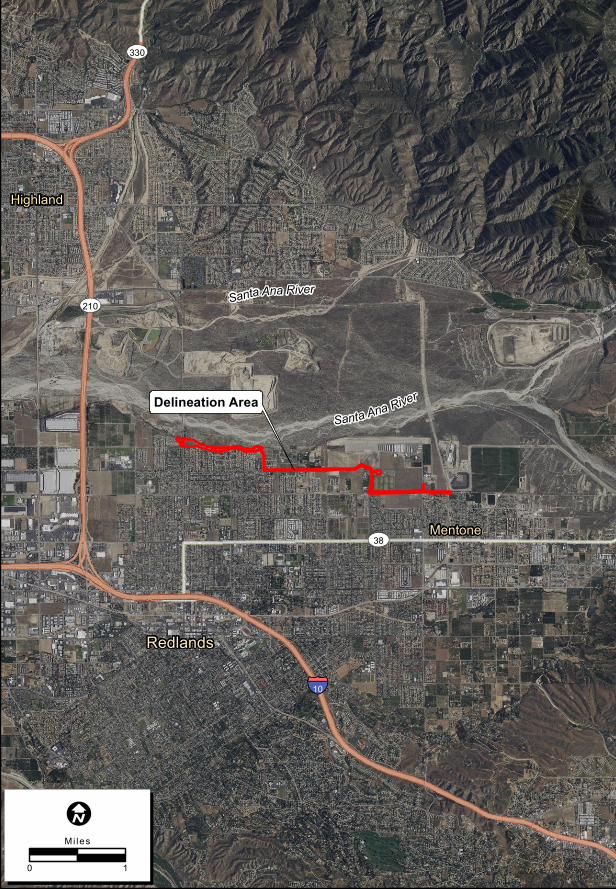
Exhibit A: Regional Location Map

Santa Ana River
Exhibit 2. Local Vicinity
Loca
tion:
N:\20
18\20
18-11
4 San
ta An
a Rive
r Trai
l Pha
se IV
\MAP
S\Loc
ation
_Vicin
ity\SA
RT_L
ocalV
icinity
_USG
Sbas
e_V2
.mxd
(LMK
)-lking
8/31
/2018
Map Date: 8/31/2018
Size of printing extent and margins differs with printer settings, please adjust margins if necessary.NOTE: This map is set up in NAD 1983 StatePlane California V FIPS 0405 Feet.
Please Change to Define Your Local State Plane or UTM Coordinate System.
Delineation Area
Service Layer Credits: Copyright:© 2013 National Geographic Society, i-cubed
2018-114 Santa Ana River Trail Phase IV
I
0 1
Mi les
chaguilar
Text Box
Exhibit "A" - Regional Location Map
Santa Ana River Trail Phase IV, Reaches B and C Project
Exhibit B: Project Vicinity Map
Redlands
Mentone
Highland
Delineation Area
ST210
ST330
ST38
§̈¦10
Santa Ana River
Santa Ana River
Exhibit 3. Local Vicinity Map
Loca
tion:
N:\20
18\20
18-11
4 San
ta An
a Rive
r Trai
l Pha
se IV
\MAP
S\Loc
ation
_Vicin
ity\SA
RT_L
ocalV
icinity
_Aeri
alBas
e_V2
.mxd
(LMK
/JDS)-
JSwag
er 9/1
3/201
8
Map Date: 9/13/2018
Size of printing extent and margins differs with printer settings, please adjust margins if necessary.NOTE: This map is set up in NAD 1983 StatePlane California V FIPS 0405 Feet.
Please Change to Define Your Local State Plane or UTM Coordinate System.
Service Layer Credits: Esri, USDA Farm Service Agency
2018-114 Santa Ana River Trail Phase IV
I
0 1
Mi les
chaguilar
Text Box
Exhibit "B" - Project Vicinity Map
Santa Ana River Trail Phase IV, Reaches B and C Project
Exhibit C: Project Location Map
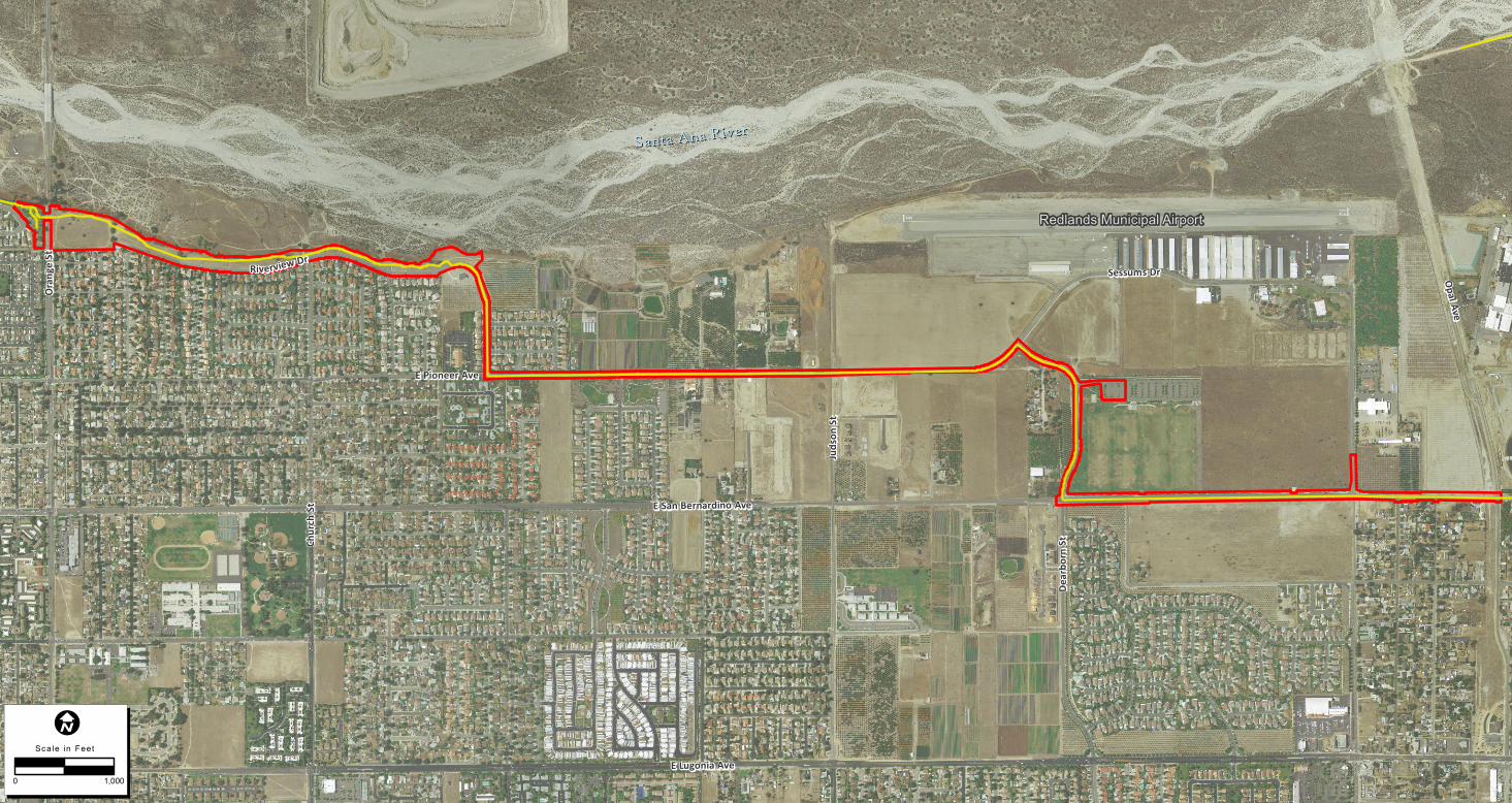
SSaannttaa AAnnaa RRiivveerr
Redlands Municipal Airport
RRiivvee rrvv iieeww DDrr
Orange
StOra
nge St
E Pioneer AveE Pioneer Ave
Opal AveOpal Ave
Dearb
orn St
Dearb
orn St
Sessums DrSessums Dr
Churc
h St
Churc
h St
Judson
StJud
son St
E San Bernardino AveE San Bernardino Ave
E Lugonia AveE Lugonia Ave
2018-114 Santa Ana River Trail Phase IV
Map Date: 9/12/2018Photo Source: 2014, USGS Exhibit 4. Project Features Map
Loca
tion:
N:\20
18\20
18-11
4 San
ta An
a Rive
r Trai
l Pha
se IV
\MAP
S\Loc
ation
_Vicin
ity\SA
RT_P
rojec
t_Fea
tures
_V2.m
xd (M
AG/JD
S)-JSw
ager
9/12/2
018
I
0 1,000
Scale in Feet
Map FeaturesDelineation AreaProposed Trail Alignment
chaguilar
Text Box
Exhibit "C" - Project Location Map
Santa Ana River Trail Phase IV, Reaches B and C Project
Exhibit D: County of San Bernardino Department of Public Works – Transportation Plans for Construction on Santa Ana River Trail (SART) Phase IV, Reaches B and C