Water level variations within the Lower Mekong River ... · Water level variations within the Lower...
23
Water level variations within the Lower Mekong River network derived by satellite altimetry Eva Boergens, Denise Dettmering, Franziska Göttl, Christian Schwatke, Florian Seitz Deutsches Geodätisches Forschungsinstitut der Technischen Universität München (DGFI-TUM) email: [email protected]
Transcript of Water level variations within the Lower Mekong River ... · Water level variations within the Lower...

Water level variations within the Lower Mekong River
network derived by satellite altimetry
Eva Boergens, Denise Dettmering, Franziska Göttl, Christian Schwatke, Florian Seitz
Deutsches Geodätisches Forschungsinstitut der
Technischen Universität München (DGFI-TUM)
email: [email protected]

Eart
h O
bserv
ation f
or
Wate
r C
ycle
Scie
ne 2
015
Motivation
2
• For monitoring and modelling the water cycle it is necessary to have knowledge of water levels of inland waters
• However, the number of available in-situ gauges is decreasing
=> Satellite altimetry can be used to close this gap of data

Eart
h O
bserv
ation f
or
Wate
r C
ycle
Scie
ne 2
015
Introduction
3
• We are using satellite altimetry data for observing inland water bodies
• Case study for the lower Mekong River in South East Asia
Eart
h O
bserv
ation f
or
Wate
r C
ycle
Scie
ne 2
015
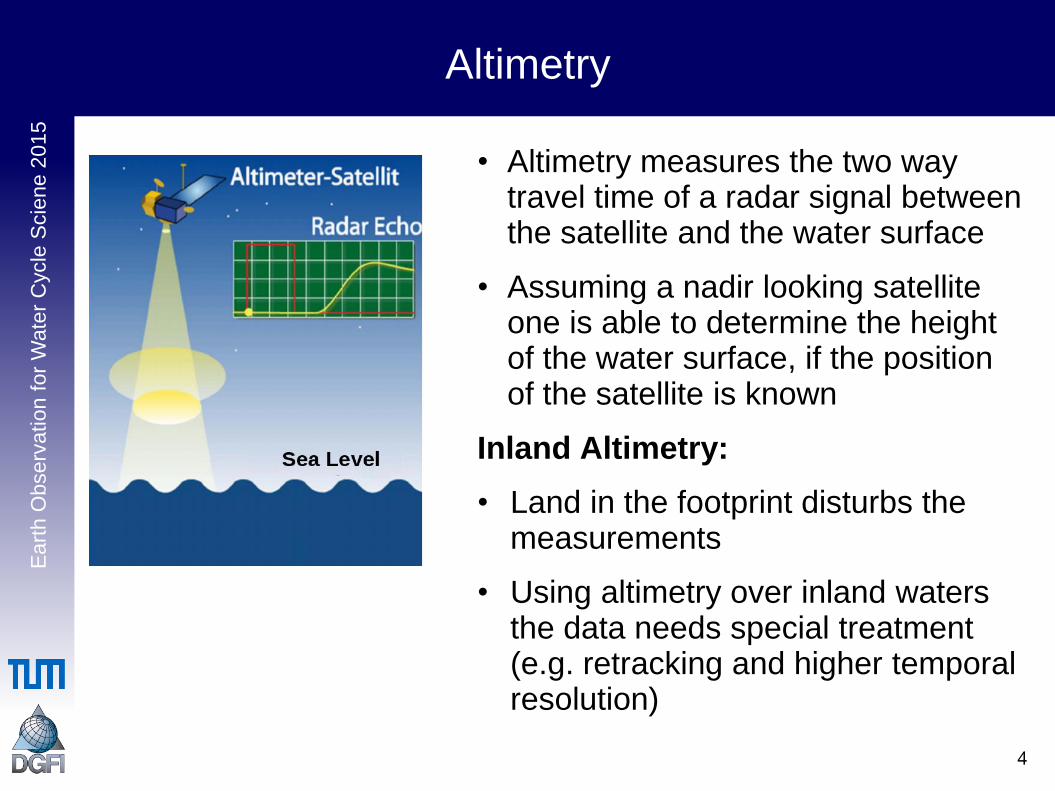
Altimetry
4
• Altimetry measures the two way travel time of a radar signal between the satellite and the water surface
• Assuming a nadir looking satellite one is able to determine the height of the water surface, if the position of the satellite is known
Inland Altimetry:
• Land in the footprint disturbs the measurements
• Using altimetry over inland waters the data needs special treatment (e.g. retracking and higher temporal resolution)

Eart
h O
bserv
ation f
or
Wate
r C
ycle
Scie
ne 2
015
Data
5
We are using 5 satellite altimetry missions:
• Envisat (2002 – 2010)
• Envisat EM (2010 – 2011)
• Saral/AltiKa (2013 – today)
• Jason-2 (2008 – today)
• Cyrosat-2 (2010 – today)
Missions with repeat orbit
Missions with long-repeat orbit

Eart
h O
bse
rvatio
n f
or
Wate
r C
ycle
Scie
ne 2
015
Repeat and non-repeat missions
6
Repeat orbit:
• Returning measurements at the same point (35 days Envisat, 10 days Jason-2)
• Data can be composed to time series
Long-repeat orbit:
• Very long repeating time (369 days for Cryosat-2)
• Denser spatial distribution
• No time series extraction possible

Eart
h O
bserv
ation f
or
Wate
r C
ycle
Scie
ne 2
015
From altimetry data to water level time series
7
• For each crossing point of a altimeter track with the river we get one time series
• All measured height over the river at one pass are taken to calculate one water level for this epoch
• Mean water level is reduced for better comparision

Eart
h O
bserv
ation f
or
Wate
r C
ycle
Scie
ne 2
015
From altimetry data to water level time series
8
• For each crossing point of a altimeter track with the river we get one time series
• All measured height over the river at one pass are taken to calculate one water level for this epoch
• Mean water level is reduced for better comparision

Eart
h O
bserv
ation f
or
Wate
r C
ycle
Scie
ne 2
015
9
Altimetry for hydrology

Eart
h O
bserv
ation f
or
Wate
r C
ycle
Scie
ne 2
015
Hydrological discontinuity
10
Hydrological discontinuity occurs between Vientiane and Nakhom Phanom:
• Upstream the river flood is governed by the precipitation on the Tibetan plateau
• Downstream by the precipitation of the monsoon
• This leads to different flood and drought behavior up and downstream
• Visible in altimetry data

Eart
h O
bserv
ation f
or
Wate
r C
ycle
Scie
ne 2
015
Hydrological discontinuity
11
Two altimetry time series, one above and one below the hydrological discontinuity

Eart
h O
bserv
ation f
or
Wate
r C
ycle
Scie
ne 2
015
Hydrological discontinuity
12
Two altimetry time series, one above and one below the hydrological discontinuity 2003: above a drought,
below normal
2008: above a flood, below a drought/normal

Eart
h O
bserv
ation f
or
Wate
r C
ycle
Scie
ne 2
015
Mekong Falls
13
• Series of rapids and falls over 10 km
• Highest step falls 21 m
https://commons.wikimedia.org/wiki/File:Khone_Phapheng_Falls_-_2.jpg

Eart
h O
bserv
ation f
or
Wate
r C
ycle
Scie
ne 2
015
Mekong Falls
14
• Cryosat pass directly over waterfall
• Stretches of water and drop are clearly visible in altimeter measurements

Eart
h O
bserv
ation f
or
Wate
r C
ycle
Scie
ne 2
015
Height profile of Mekong
15
Mekong Falls
Begin of the mountains

Eart
h O
bserv
ation f
or
Wate
r C
ycle
Scie
ne 2
015
Topography Influence - Example Luang Prabang
16
1
2

Eart
h O
bserv
ation f
or
Wate
r C
ycle
Scie
ne 2
015
Topography Influence - Example Luang Prabang
17
1
2

Eart
h O
bserv
ation f
or
Wate
r C
ycle
Scie
ne 2
015
Topography Influence - Amplitude Differences
18
At Luang Prabang 2 and the gauging station the river can expand more than at Luang Prabang 1. This leads to the differences of amplitude.
La
nd
sa
t 7

Eart
h O
bserv
ation f
or
Wate
r C
ycle
Scie
ne 2
015
Altimetry time series in the Mekong region
19

Eart
h O
bserv
ation f
or
Wate
r C
ycle
Scie
ne 2
015
Altimetry time series in the Mekong region
20
• Data gap between 2010 and 2013 (between the Envisat and Saral missions)
• Cryosat 2 data might close this gap
• Long-repeat mission
• -> no time series from which we can reduce mean level
• Mean level has to be estimated with the topography

Eart
h O
bserv
ation f
or
Wate
r C
ycle
Scie
ne 2
015
Altimetry time series in the Mekong region
21

Eart
h O
bserv
ation f
or
Wate
r C
ycle
Scie
ne 2
015
Conclusion
22
• Inland altimetry proves to be a valuable tool for hydrology in the Mekong region
• Altimetry is globally available, even for remote locations
• By now at least 15 years of time series are available (can be expanded further back with less accuracy)
• The use of data from long-repeat missions is still challenging but can close the data gap between Envisat and Saral
Eart
h O
bserv
ation f
or
Wate
r C
ycle
Scie
ne 2
015
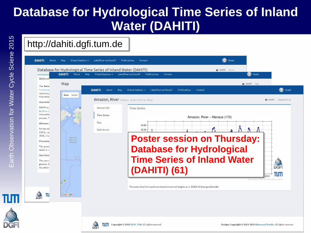
Database for Hydrological Time Series of Inland
Water (DAHITI)
23
http://dahiti.dgfi.tum.de
Poster session on Thursday: Database for Hydrological Time Series of Inland Water (DAHITI) (61)