Water criticality in the Colli Albani (Rome, Italy)
11
Giornale di Geologia Applicata 1 (2005) 261 –271, doi: 10.1474/GGA.2005-01.0-26.0026 Water criticality in the Colli Albani (Rome, Italy) 1 Giuseppe Capelli & Roberto Mazza Dipartimento di Scienze Geologiche, Università degli Studi “Roma Tre” L.go S. Leonardo Murialdo, 1 – 00146 Roma Italy. e-mail: [email protected] ABSTRACT. The Colli Albani Hydrogeological Unity has a good regional water resource. The geological setting of the area has been defined reconstructing the morphology of roof of prevolcanic substratum and the geometry of the aquifers by the realization of cartographies made of several profiles to different scales. The project of hydrogeological surveying of wells, springs and discharge’s streams have been led to define the state of conservation of water resources. The results of this research have underlined a distributed and relevant drawdown of ground water table and of river capacity network. Specific studies, supported by cartographies elaborated by GIS, have been led to define all the parameters concerning the hydrogeological balance: precipitation, evapotranspiration, runoff, effective infiltration, withdrawals. The analysis of the hydrogeological balance, have led to a definition of specific rules for the management of water resources in order to recover the situations of over-exploitation. Key terms: Aquifer, Aquifer drawdown, Hydrogeological balance, Latium Italy, Alban Hills 1 Studio effettuato con il finanziamento dell’INGV – “Pericolosità associata alla risalita di fluidi endogeni nei Colli Albani” – Responsabile Prof. Renato Funiciello. Introduction The Colli Albani volcano has been the most important water resource of the city of Rome since Roman times. The volcanic succession, which overlies a clayey aquiclude of Pliocene age, can be considered as an individual aquifer, although the permeability associated with interbedded lavas and pyroclastic rocks is highly variable, both laterally and vertically. The area was rapidly urbanized during the second half of the 20 th century, with the consequent proliferation of urban and industrial settlements, as well as intensive farming activities. FIG. 1:Volcanic and sedimentary structures and their relations (Modified after DE RITA et alii, 1988). LEGEND: 1) Product of the Albano activity; 2) Product of the Faete activity; 3) Product of the Tuscolano-Artemisio activity; 4) Marine and/or continental clay and sand deposits Pliocene-Quaternary; 5) Clayey arenaceous Miocene flysch; 6) Carbonate succession Mesozoic-Cenozoic; 7) Intrusive magmatic body; 8) Thermometamorphic facies.
Transcript of Water criticality in the Colli Albani (Rome, Italy)

Giornale di Geologia Applicata 1 (2005) 261 –271, doi: 10.1474/GGA.2005-01.0-26.0026
Water criticality in the Colli Albani (Rome, Italy)1
Giuseppe Capelli & Roberto MazzaDipartimento di Scienze Geologiche, Università degli Studi “Roma Tre” L.go S. Leonardo Murialdo, 1 – 00146 Roma Italy. e-mail:
ABSTRACT. The Colli Albani Hydrogeological Unity has a good regional water resource. The geological setting of the areahas been defined reconstructing the morphology of roof of prevolcanic substratum and the geometry of the aquifers by therealization of cartographies made of several profiles to different scales. The project of hydrogeological surveying of wells,springs and discharge’s streams have been led to define the state of conservation of water resources. The results of thisresearch have underlined a distributed and relevant drawdown of ground water table and of river capacity network. Specificstudies, supported by cartographies elaborated by GIS, have been led to define all the parameters concerning thehydrogeological balance: precipitation, evapotranspiration, runoff, effective infiltration, withdrawals. The analysis of thehydrogeological balance, have led to a definition of specific rules for the management of water resources in order to recoverthe situations of over-exploitation.
Key terms: Aquifer, Aquifer drawdown, Hydrogeological balance, Latium Italy, Alban Hills
1 Studio effettuato con il finanziamento dell’INGV – “Pericolosità associata alla risalita di fluidi endogeni nei Colli Albani”– Responsabile Prof. Renato Funiciello.
IntroductionThe Colli Albani volcano has been the most importantwater resource of the city of Rome since Roman times. Thevolcanic succession, which overlies a clayey aquiclude ofPliocene age, can be considered as an individual aquifer,although the permeability associated with interbedded lavas
and pyroclastic rocks is highly variable, both laterally andvertically.
The area was rapidly urbanized during the second halfof the 20th century, with the consequent proliferation ofurban and industrial settlements, as well as intensivefarming activities.
FIG. 1:Volcanic and sedimentary structures and their relations (Modified after DE RITA et alii, 1988). LEGEND: 1) Product of the Albanoactivity; 2) Product of the Faete activity; 3) Product of the Tuscolano-Artemisio activity; 4) Marine and/or continental clay and sanddeposits Pliocene-Quaternary; 5) Clayey arenaceous Miocene flysch; 6) Carbonate succession Mesozoic-Cenozoic; 7) Intrusive magmaticbody; 8) Thermometamorphic facies.

Capelli G., Mazza R., / Giornale di Geologia Applicata 1 (2005) 261 – 271 262
At present, water pumping in the area is intense andlargely uncontrolled, leading to over-exploitation of theaquifer so that the groundwater table is lowered by severaltens of meters and locally by up to 100 m. This finding
suggests that water pumping is such as to deplete the localstrategic reservoir, making it necessary to implementcorrect water management policies and practices.
FIG. 2: Geological sketch map of the Colli Albani volcanic complex (DE RITA et alii, 1995). LEGEND: 1) Travertine; 2) Plio-Pleistocenesedimentary units; 3) Colli Albani final hydromagmatic phase products; 4) Colli Albani Faete phase products; 5) Colli Albani Tuscolano-Artemisio phase products; 6) Lava flows; 7) Sabatinian hydromagmatic units; 8) Sabatinian air-fall deposits; 9) Sabatinian ignimbrites;10) Tortonian flysch (pelitic.sandy facies); 11) Meso-Cenozoic pelagic carbonate units (Sabina facies); 12) Meso-Cenozoic carbonateplatform units (Latium-Abruzzi facies); 13) Caldera rims; 14) Crater rims: a) Ariccia, b) Nemi, c) Albano, d) Giuturna, e) Valle Marciana,f) Pantano Secco, g) Prata Porci, h) Castiglione; 15) Hydrogeological cross-section (see FIG. 3).

Capelli G., Mazza R., / Giornale di Geologia Applicata 1 (2005) 261 – 271 263
Geological settingThe Colli Albani volcanic succession rests on a post-orogenic Pliocene-Quaternary bedrock, which is made upof marine to continental deposits, mainly characterized byclayey and sandy sediments. These sediments cover aMesozoic-Cenozoic carbonate and terrigenous successionorogenized in Miocene times (FUNICIELLO & PAROTTO,1978) (FIG. 1).
Extensional tectonics, related to the opening of theTyrrhenian Basin, faulted the sedimentary bedrock,resulting in a NW- and NE-trending horst and grabenstructure.
The study area includes not only the Colli Albanivolcanites, but also peripheral areas. The referencegeological setting (FIG. 2) derives from studies conductedas part of the CARG Project.
The geology and structure of this volcano (inferredfrom a 1:10,000 scale geological survey and fromstratigraphic analyses of over 600 drill-holes) are outlinedbelow.
The Quaternary volcanic succession records theoccurrence of three epochs of activity (DE RITA et alii,1988).
Tuscolano-Artemisio Epoch (600-300 ka) – During thisperiod, over 283 km3 of products were emplaced (DE RITAet alii, 1995), building the Tuscolano-Artemisio centraledifice. Several, dominantly explosive eruptions emplacedlarge volume, low aspect ratio, tephritic to K-foiditicignimbrites. These ignimbrites cover an area of more than1500 km2 around the volcano center. Large volumes ofphono-tephritic lava flows were also emplaced, fillingtectonically controlled, NW- and NE-trending paleovalleys,which reflect the tectonic trends of the pre-volcanicbedrock. A 10 x 10 km-wide, composite caldera wasformed in the central area of the volcano as a consequenceof large-volume eruptions. In the investigated area, NW-trending caldera faults were identified, which downthrowthe volcanic succession by several hundred meters towardsNE (FIG. 3). The volcanic succession overlies a Pliocene-Middle Pleistocene sedimentary succession, with dominantclayey and sandstone lithologies. The morphology of thetop of the sedimentary bedrock (inferred from drill-holesand geoelectric data) shows valleys and ridges at anelevation of, respectively, -70 m below and 50 m abovesea level.
FIG. 3: Geological and hydrogeological cross-section. (LEGEND: – 1): Products of the Albano activity a) Conduit breccia; 2): Productsof the Faete activity; 3): Ignimbrites of the Tuscolano-Artemisio activity; 4): Lava; 5): Pre-volcanic bedrock; 6): Well; 7): Fault; 8): 1999isopiezometric level; 9): 1972 isopiezometric level) (Modified after GIORDANO et alii, 2000).
Faete Epoch (300-100 ka) - After the last calderacollapse in the Tuscolano-Artemisio period (338 ka; DERITA et alii, 1995), the volcanic activity concentratedwithin the collapsed area, where the 6 km3 Faete volcanicedifice filled the caldera with lavas and strombolian tosubplinian pyroclastic products. Some of the lavas
overflowed the caldera wall (e.g. Capo di Bove lava, 285ka), reaching the area presently occupied by Rome.
Albano Epoch (100-<20 ka) – The latest period ofvolcanic activity was dominantly characterized byphreatomagmatic eruptions from eccentric, monogenic andcoalescing maars, tuff rings and tuff cones, some of which

Capelli G., Mazza R., / Giornale di Geologia Applicata 1 (2005) 261 – 271 264
are presently filled by lakes (e.g. Lake Albano). In theinvestigated area, the phreatomagmatic centers are alignedalong the NW-trending caldera faults and more recent N-trending lineaments. In this epoch, a further reduction inthe volume of erupted magma is likely to have favored theefficiency of magma-water interaction.
At present, the Colli Albani volcano is commonlyregarded as non-active, because its most recent productswere dated between 19,000 and 36,000 years B.P.(FORNASERI, 1985; VOLTAGGIO et alii, 1994). However,the Colli Albani area is characterized by frequent episodesof seismic activity, local uplift, hydrothermal circulation
and gas emissions, pointing to the presence of a coolingmagma body lying beneath the volcano, at a depth ofapproximately 6 to 18 km (AMATO & CHIARABBA, 1995).
Hydrogeological settingThe Colli Albano volcano is a Hydrogeological Unit(CAHU) bounded by the Aniene River to the north, theTiber River to the northwest, the Tyrrhenian Sea to thesouthwest, the Acque Alte Floodway to the southeast, andthe Sacco River to the east (FIG. 4).
FIG. 4: Location map showing the Albano Volcano and its surrounding area (Modified after BONI et alii, 1995).
The volcanic succession and its aquifers (hereinaftercollectively referred to as "the volcanic aquifer") lie over athick, marine, clayey succession of Pliocene-Pleistoceneage, several hundred meters thick. This successionrepresents the lower aquiclude, which also bounds a deepergeothermal aquifer, hosted in the underlying Mesozoic-Cenozoic carbonate succession. The geometry of the top of
the clayey aquiclude has been reconstructed viageophysical analyses and deep-well data (ENEL, 1990; DERITA et alii, 1992), indicating that several extensional faultsystems (NW-, NE- and N-trending systems) cut it into ahorst and graben structure. The aquiclude is alsodownthrown in the vicinity of the central caldera of thevolcano (FIG. 3). Preferential groundwater flowpaths have

Capelli G., Mazza R., / Giornale di Geologia Applicata 1 (2005) 261 – 271 265
been recognized within the aquiclude lows (i.e. graben).The faults favor the rise of deep-seated fluids (gas andthermal water), which locally contaminate the volcanicaquifer (e.g. specific conductivity of 14000 µS/cm in oneof the Solforata wells, 1200 µS/cm in the Solforata andCava de’ Selci areas, 2100 µS/cm in the Ardea area).
The overall hydrogeology of the CAHU may beoutlined as follows (CAPELLI et alii, 1998):- the intra-caldera sector is the upper portion of the volcanoand hence the recharge area of the aquifer, which crops outin Lake Albano.
- the extra-caldera sector is characterized by flowpathswhich are radial and centrifugal with respect to the volcanocenter. The three-dimensional lithological variability of thevolcanic bodies gives rise to locally perched aquifers, aswell as confined aquifers.
Assessment of water resource conservationIn the Lake Albano area, a regional aquifer and ashallower, perched aquifer were identified (REGIONELAZIO, 1999). s well as confined aquifers. The regionalpiezometric level (FIG. 5) is presently located at approx.200 m above sea level and its drainage has a SW direction.
FIG. 5: Hydrogeological map of the Colli Albani volcanic complex. LEGEND: 1) Well; 2) Stream gauging station; 3) Regional piezometriclevel; 4) Ground water basin boundary with a reference number.

Capelli G., Mazza R., / Giornale di Geologia Applicata 1 (2005) 261 – 271 266
The piezometric level of the perched aquifer crops outin the lakes of Nemi and Albano. As Lake Albano is 175 mdeep (about 120 m above sea level), it intercepts both waterflows. Since 1848, the level of the lake has been measuredwith respect to the elevation of the inlet of a drainagegallery excavated during the Roman age (DRAGONI, 1998).Data from 1951 to 1990 indicate that the level of the lakefluctuated with rainfall (FIG. 6). By contrast, the trend ofprecipitation from 1990 to 1997 (latest officialmeasurement) does not justify the steep decrease of LakeAlbano’s water level, which presently lies at least 3 mbelow the inlet.
The river network of the CAHU has a radialconfiguration, forming 26 drainage basins, the surface areaof which ranges from 282 km2 to 4 km2. Seventeen of themare perennial and drain the regional aquifer at elevationscomprised between 70 and 50 m above sea level. Thecomparison of the low-water discharge rates measuredfrom 1978 to 1979 (BONI et alii, 1981; BONO et alii, 1983),from 1997 to 1999 (REGIONE LAZIO, 1999) and in 2002 bythe local basin authorities (AUTORITÀ DEI BACINI
REGIONALI DEL LAZIO & AUTORITÀ DI BACINO DEL FIUMETEVERE, 2003) shows: i) a substantial decrease, whichstarted in the 1990s; and ii) an apparent stability in the lasttwo water-level monitoring programs, which was due,among other things, to intense rainfall in the summer of2002. Cumulated discharges, in the above-mentionedperiods, are equal to 5,620 l/s, 3,050 l/s and 3,830 l/s,respectively (FIG. 7).
To assess changes in the regional piezometric level ofthe CAHU, a comparison was made of hydrogeologicaldata collected in the past four decades. This comparisonevidences a significant drawdown of the water table,reflecting locally over-exploited areas (FIG. 8).
For example, the drawdown recorded in the Pavonaarea in the past decade reached 100 m (FIGS 3 and 8). Theplains surrounding the volcano display a generalizeddrawdown of the water table (10-20 m).
Locally, where the shallowing of the clayey aquicludereduced the thickness of the aquifer to values comparablewith the drawdown (for example Pomezia), the waterresource is completely depleted.
FIG. 6: Water level fluctuations in Lake Albano vs. yearly average rainfall recorded in the gauging stations of Agenzia ProtezioneAmbiente e Territorio of the Alban area. LEGEND: 1) Annual precipitation; 2) Polynomial precipitation curve; 3) Mean annual level ofthe Albano Lake; 4) Polynomial lake-level curve.
In the early 2000s, along the coast, groundwater levelslower than sea level were recorded for the first time. Theonly areas where the groundwater level rose were formerfarmland areas where water pumping had ceased.
Areas with significant drawdown of the water table aredefined as critical. In such areas, under present conditionsof recharge, “withdrawal is such as to disturb groundwater
circulation and lower the level of the water table to a muchgreater extent than in surrounding areas, thus jeopardizingwater supply to anthropic settlements and causing anunsustainable decrease of the natural discharge of theaquifer in the subsoil and towards the surface” (REGIONELAZIO, 2004).

Capelli G., Mazza R., / Giornale di Geologia Applicata 1 (2005) 261 – 271 267
FIG. 7: Comparison between 2002, 1997-19/99 and 1978-19/79 discharge values of the hydrographic basins that drain the Colli Albanivolcano area.
The criticality of the local aquifer was assessed byreferring to its physical characteristics, evidence ofdepletion, water-withdrawing entities and water uses. Onthe basis of the findings from hydrogeological studiesconducted in the Colli Albani area, the following criticalfactors were investigated:- groundwater level anomalies – differences between the
regional trend of the present groundwater level(reconstructed from the analysis of the regional trenddefined as the mean value of the groundwater levelwithin a radius of 3 km) and the groundwater levelcalculated on the basis of experimental measurements;
- thickness of the aquifer – difference between thegroundwater level and the level of the top of the pre-volcanic substratum;
- density of known wells - obtained from the locations ofall the wells stored in data bases (measured by theAuthors, quoted in scientific papers and retrieved in thearchives of the relevant authorities);
- location of water intakes (var. points of withdrawal ofwater) for drinking uses;
- areas of withdrawal for industrial uses;- areas of withdrawal for farming uses;
- extensive over-exploitation of the water body (ratio ofnatural recharge to withdrawals).
The critical areas are identified via a GeographicInformation System (using a grid with a 250-m side mesh)in an objective way, i.e. via a software program whichindexes the above critical factors according to anassessment matrix. The higher the index, the heavier theweight of the critical factor on the criticality of the area.For each portion of the investigated aquifer, the totalcriticality is given by the summation of the various indices.The weight of the various critical factors was selected onthe basis of strictly hydrogeological factors, assigning themaximum weight to the anomalies observed ingroundwater level and to the presence and extent ofwithdrawals for aqueducts, i.e. the priority use of theresource. From a technical viewpoint, further insight intothe issue might lead to a more accurate identification of thelevels of risk and of the geometry of the critical areas.
This procedure thus represents a tool for investigatingaquifer vulnerability, but also for formulating sustainablewater resource management policies. The procedure alsodefined “attention” areas, whose criticality is mainlydependent on groundwater level anomalies, but where thecalculated withdrawal is not particularly high.

Capelli G., Mazza R., / Giornale di Geologia Applicata 1 (2005) 261 – 271 268
FIG. 8: Balance, critical areas and attention areas in the CAHU. LEGEND: 1) Ground water basin boundary; 2) Critical area; 3) Attentionarea; 4) Reference number.
Analysis of HydrogeologicalThe study involved detailed computations of thehydrogeological balance, requiring highly accurate dataconcerning the distribution of recharge and withdrawals intime and space. To analyze the relationships betweenrecharge and withdrawals, the hydrogeological balance isbuilt is such a way as to highlight a deficit, i.e. thedifference between inflows and total outflows.
To estimate the terms of the balance in the CAHU,resort was made to a specific methodology taking intoaccount: i) physical factors affecting aquifer recharge; ii)anthropogenic disturbances due to withdrawals anddiversions of surface and underground water bodies; iii)variation (in time and space) of non-structural limits of
hydrogeological basins (recharge areas), which changewith inflows and intensity of withdrawals.
The hydrogeological balance methodology used in thisstudy has the following features:- it analyses the variability (in time and space) of rainfall
and climate on a monthly basis, dividing theinvestigated area into 250 m-side cells;
- it takes into account the impact of morphology,lithology, pedology, vegetation and land use on runoffand evapotranspiration, with a high level of spatialdetail;
- it permits us to compare the distribution and extent ofwithdrawal with the distribution of net recharge;

Capelli G., Mazza R., / Giornale di Geologia Applicata 1 (2005) 261 – 271 269
- it allows data to be updated with respect to thereference period and aggregate them by individualhydrogeological basin.The analysis of Table 1 suggests the following major
considerations.The comparison of precipitation in the period from
1997 to 2001 with precipitation in the period from 1981 to1985 indicates a decrease of about 180 mm/yr and a
corresponding decline in net recharge from 351 mm/yr to242 mm/yr.
This situation is compounded by the fact that totalwithdrawal (for drinking, irrigation and industrial uses) hasan impact on net recharge. In effect, throughout the CAHU,groundwater withdrawal accounts for 74% of the rechargevolume.
TABLE. 1: Hydrogeological balances of the CAHU
.
TABLE 2: Hydrogeological balance of groundwater basin 1 – Cisterna-Velletri.
Capelli G., Mazza R., / Giornale di Geologia Applicata 1 (2005) 261 – 271 270
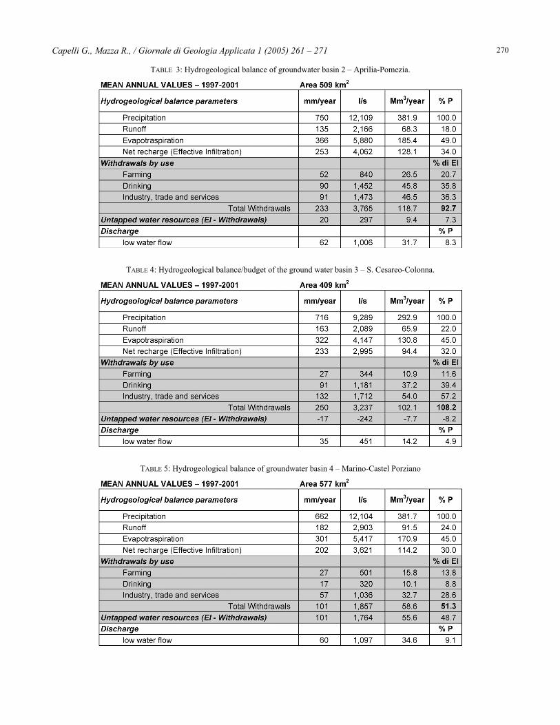
TABLE 3: Hydrogeological balance of groundwater basin 2 – Aprilia-Pomezia.
TABLE 4: Hydrogeological balance/budget of the ground water basin 3 – S. Cesareo-Colonna.
TABLE 5: Hydrogeological balance of groundwater basin 4 – Marino-Castel Porziano
Capelli G., Mazza R., / Giornale di Geologia Applicata 1 (2005) 261 – 271 271
Balance computations infer that withdrawal in theAprilia – Pomezia (TABLE 3) and S. Cesareo – Colonna(TABLE 4) basins vs. withdrawal in the four investigatedhydrogeological basins (TABLES 2, 3, 4 and 5), exceeds thevolume of recharge and is around 110%.
In the remaining Cisterna – Velletri (TABLE 2) andMarino – Castel Porziano (TABLE 5) basins, withdrawalaccounts for about half of recharge.
ConclusionsThe Colli Albani volcano is a complex hydrogeological
unit, which hosts an important regional aquifer, as well asperched aquifers. The regional aquifer is sustained by aclayey aquiclude. This is cut by extensional faults, whichfavor the upwelling of deep-seated fluids, giving rise to gasemission points and to mineralized, thermal and cold watersprings. The regional aquifer feeds the radially configuredriver network of the CAHU, as well as point springs.
In the past two decades, the equilibrium of the regionalwater resources in the CAHU area broke down, resulting inthe following evidence:- 3-m drawdown of the water level at the top of the
volcano (Lake Albano);- heavy decrease in river discharge (about 50%);- generalized drawdown of groundwater level in wells
(locally up to 100 m);- drawdown of groundwater level below sea level near the
coast.Water withdrawal proved to decrease the calculated
value of net recharge by 74% throughout the CAHU.Taking into account the extent of withdrawal and the
hydrogeological aspects, the study identified areas wherethe equilibrium between recharge and exploitation hasbecome unsustainable (critical areas). This situation israpidly depleting the regional aquifers and, with decreasingprecipitation, is triggering an irreversible process.
ReferencesAMATO A. & CHIARABBA C. (1995) –Earthquake occurrence and crustal structure. In:TRIGILA R. (1995 Ed.) – The volcano of theAlban Hills, SGS Press, Roma.AUTORITÀ DEI BACINI REGIONALI DEL LAZIO &AUTORITÀ DI BACINO DEL FIUME TEVERE (2003)– Studi Idrogeologici per la definizione deglistrumenti necessari alla redazione dei pianistralcio relativi agli acquiferi vulcanici delterritorio della Regione Lazio. (Unpublishedreport), Roma.BONI C., BONO P., CAPELLI G., ROSSI F.M. &SHOLL C. (1981) – Tentativo di bilancioidrogeologico dell’area albana nel periodoottobre 1978-settembre 1979. Atti II seminarioinformativo PFE-EG, CNR, 93-113.BONI C., BONO P., LOMBARDI S., MASTROLILLOL. & PERCOPO C. (1995) – The Volcano of theAlban Hills: Hydrogeology, Fluid Geochemistryand Thermalism. In: TRIGILA R. (1995 Ed.) –The volcano of the Alban Hills, SGS Press,Roma.BONO P., CHIARINI W., RABOTTINO S. & ROSSIF.M. (1983) – Idrologia dell’area vulcanicaalbana: campagna di rilevamento aprile 1981-aprile 1982. (Unpublished report). Enel-UNG.CAPELLI G., MAZZA R. & GAZZETTI C. (Eds.)(In press) – Strumenyi e strategie per la tutela el’uso compatibile della risorsa idrica del Lazio.Gli acquiferi vulcanici. Quaderni di Tecniche diProtezione Ambientale n. 78, pp. 208, 4 tavv. F.t., CD-ROM allegato, Pitagora, Bologna.CAPELLI G., CECILI A., DE RITA D., GIORDANOG. & MAZZA R. (1998) - La conoscenza
idrogeologica del territorio quale presuppostoalla gestione delle risorse idriche: il caso deiColli Albani. - In: contributi tecnico scientificialla giornata di studio: "Uso e Tutela delleacque sotterranee", April 3rd, 1998 Viterbo - 52pp, 31 figg. - Ordine dei Geologi del Lazio -Associazione Nazionale di Idrogeologia e Pozziper Acqua -Regione Lazio, Assessorato Opere eServizi di Reti e mobilità.CAPELLI G., MAZZA R., GIORDANO G., CECILIA., DE RITA D. & SALVATI R. (2000) – The ColliAlbani volcano (Rome, Italy): equilibriumbreakdown of a hydrogeological unit as a resultof unplanned and uncontrolled over-exploitation.Hydrogéologie, 4, 63-70.DE RITA D., FACCENNA C., FUNICIELLO R. &ROSA C. (1995) – Stratigraphy and volcano-tectonics. In: TRIGILA R. (1995 Ed.) – Thevolcano of the Alban Hills, SGS Press, Roma.DE RITA D., FUNICIELLO R. & PAROTTO M.(1988) – Geological map of the Colli AlbaniVolcanic Complex (“Vulcano Laziale”). CNR.Roma.DE RITA D., FUNICIELLO R. & ROSA C. (1992) –Volcanic activity and drainage network evolutionof the Alban Hills area (Rome, Italy). ActaVolcanologica, 2, 185-198.DRAGONI W. (1998) – Some considerations onclimatic changes, water resources and waterneeds in the Italian region south of the 43°N. In:BROWN N.& ISSAR A.S. (1996 Eds) Water,Environment and Society in Times of ClimaticChange. Kluwier Academic Publ. Netherlands,241-271.
ENEL (1990) – L’esplorazione geotermica nelp.r. Colli Albani. (Unpublished report).FORNASERI M. (1985) - Geochronology ofvolcanic rocks from Latium (Italy). Rend. Soc. It.Min. Petr., 40, 73-106.FUNICIELLO R. & PAROTTO M. (1978) – Ilsubstrato sedimentario nell’area dei ColliAlbani: considerazioni geodinamiche epaleogeografiche sul margine tirrenicodell’Appennino Centrale. Geol. Rom., 17, 233-287.GIORDANO G., MAZZA R., CECILI A., CAPELLIG., DE RITA D. BIGI G. &, RODANI. S. (2000) -Cities on volcanoes: groundwater resources andmanagement in a highly populated volcanicregion. A GIS in the Colli Albani region, Rome,Italy. Journal of the Nepal Geological Society,22, 315-326, Kathmandu, Nepal.REGIONE LAZIO (1999) – Studio idrogeologicodel complesso vulcanico dei Castelli Romani esistema gestionale per la tutela della risorsaidrica – ST 10. (Unpublished report). RegioneLazio - Ass. Opere e Reti di Servizi e Mobilità.REGIONE LAZIO (2004) – Misure di salvaguardiadegli acquiferi vulcanici dei Colli Albani e deiMonti Sabatini. Bollettino Ufficiale dellaRegione Lazio suppl. ordinario n. 4 al“Bollettino Ufficiale” n. 2 del 20 gennaio 2004.VOLTAGGIO M., ANDRETTA D. & TADDEUCCI A.(1994) - 230Th-238U data in conflict with40Ar/39Ar leucite ages for quaternary volcanicrocks of the Alban Hills, Italy. Eur. J. Mineral., 6,209-216.