Washington Geology, v, 19, no. 1, March 1991€¦ · Washington Department of Natural Resources,...
52
WASHINGTON GEOLOGY formerly WASHINGTON GEOLOGIC NEWSLETTER Washington Department of Natural Resources, Division of Geology and Earth Resources Vol. 19, No. 1, March 1991 Lake Sutherland (foreground) and Lake Crescent, on the Olympic Peninsula; view to the west. Note landslide headscarps and the relati ve roughness of the surface of the landslide on the north side of the valley (right) beneath these scarps. (See article, p. 38 .) In This Issue: Washington's mineral industry- 1990 ........................ 3 Rainstorm damage in King County, Jan . 1990 ... ........ 28 Origin of Lakes Crescent and Sutherland .................... 38
Transcript of Washington Geology, v, 19, no. 1, March 1991€¦ · Washington Department of Natural Resources,...

WASHINGTON
GEOLOGY
formerly
WASHINGTON GEOLOGIC NEWSLETTER
Washington Department of Natural Resources, Division of Geology and Earth Resources Vol. 19, No. 1, March 1991
Lake Sutherland (foreground) and Lake Crescent, on the Olympic Peninsula; view to the west. Note landslide headscarps and the relative roughness of the surface of the landslide on the north side of the valley (right) beneath these scarps. (See article, p . 38.)
In This Issue: Washington's mineral industry- 1990 ..... ................ ... 3 Rainstorm damage in King County, Jan. 1990 ... ........ 28 Origin of Lakes Crescent and Sutherland ........... .... ... .. 38

WASHINGTON
GEOLOGY
Washington Geology (formerly the Washington Geologic Newsletter) is published four times a year by the Washington Division of Geology and Earth Resources, Department of Natural Resources. This publication is free upon request. The Division also publishes bulletins, information circulars, reports of investigations, geologic maps, and open-file reports. A list of these publications will be sent upon request.
DEPARTMENT OF NATURAL RESOURCES
Brian J. Boyle Commissioner of Public Lands
Art Stearns Supervisor
DMSION OF GEOLOGY AND EARTH RESOURCES
Geologists Matthew J . Brunengo (Olympia) Robert E. Derkey
(Spokane) Librarian
Joe D. Dragovich William S. Lingley, Jr Robert L. (Josh) Logan David K. Norman
Library Technician Research Technician Editor
Raymond Lasmanis State Geologist
J . Eric Schuster Assistant State Geologist
Stephen P. Palmer Patrick T. Pringle
Weldon W. Rau Katherine M. Reed Henry W. Schasse Timothy J. Walsh
(vacant)
Connie J . Manson
Rebecca Christie
Rex J. Hapala
Katherine M. Reed
Cartographers Nancy A. Eberle Carl F.T. Harris David P. Clark (Nat. Res. Aide) Keith G. Ikerd
Editorial Assistant Administrative Assistant Clerical Staff Naomi Hall
Mary Ann Shawver
Regulatory Clerical Staff
(vacant)
Barbara A. Preston
Shelley Reisher J. Renee Snider
(vacant)
Main Office Department of Natural Resources Division of Geology and Earth Resources Mail Stop PY-12 Olympia, WA 98504 Phone: (206) 459-6372 FAX: (206) 459-6380
(See map inside back cover for office location.)
Field Office Department of Natural Resources Division of Geology and Earth Resources Spokane County Agricultural Center N. 222 Havana Spokane, WA 99202 Phone: (509) 456-3255
Publications available from the Olympia address only.
Washington Geology, oo/. 19, no. 1 2
Crisis in Geoscience Education by Raymond Lasmanis
During the last decade there have been dramatic decreases in college enrollment in all areas of earth science and related fields. For example, graduates in mining engineering at 19 of our prominent universities have dropped from 793 in 1981 to 237 in 1991 (Fig. 1) . Similar declines are noted in geology, geological engineering, and metallurgy. According to the National Science Foundation (NSF), there will be a shortfall of more than 400,000 scientists and engineers by the year 2000.
A number of national governmental and professional organizations have instituted programs to rejuvenate science and mathematics teaching at public schools, with the objective of stimulating students to enter the sciences. One identified shortcoming is the lack of educational aids to sciences teachers in grades K through 12.
The Washington State school system has approximately 810,000 students and 35,000 teachers. While educators recognize the importance of science and mathematics in the curriculum, only 3 to 5 percent of the approximately 19,000 elementary school teachers have a major or minor in science or mathematics. Statistics such as these demonstrate that, in this state, most science and mathematics classes below the college level are taught by teachers that have little if any formal training in these fields. Therefore, the need for teaching modules in geological and related sciences,
(Continued on p. 51)
Actual 700 Projected
600 rn Cl) -al :::, 500 -0 as ..
C!> - 400 0 .. Cl)
300 MS .Q
E
I. Ph.D -~-~---•
:::,
z 200
100 ~-·-·-·-~ .,,,,,, .. _ ..... _.._._
80/81 82/83 84/85 86/87 88/89 90/91
Academic Year
Figure 1. The decline in mining engineering graduates during recent academic years and projected through the present year, based on surveys of 19 colleges and universities. Modified from the Northwest Mining Association 1990 Directory, p. 115.

Washington's Mineral Industry - 1990 by
Nancy L. Joseph
INTRODUCTION In 1990 five metal mines were in operation in
Washington, and one precious-metal mine was in the permitting stage. Seventeen companies mined and produced industrial minerals, which include limestone, dolomite, silica, olivine, clay, and diatomite. Two companies produced portland cement, and nine plants produced lime, calcium chloride, precipitated calcium carbonate, or ground limestone.
According to preliminary figures gathered by the U.S. Bureau of Mines (USBM) and the Division of Geology and Earth Resources (OGER), the value of the mineral industry in Washington in 1990 is estimated at $500 million. This represents an approximately 5 percent increase over the USBM total value of $480. 9 million for 1989. The combined value of sand and gravel and crushed stone production accounts for nearly 40 percent of the 1990 value. The value of precious metals produced in the state increased to $121 million from $88 million as a result of the startup of two new mines in Ferry County and continued high levels of production at two other gold mines . Magnesium metal production, the value of which was down slightly from 1989, accounts for approximately a fifth of the total value of state's mineral industry . The value and tonnage of portland cement continued to decrease because of the closure of one plant in Pend Oreille County .
The mining industry (excluding coal) in Washington employed an average of approximately 2,152 workers in 1989, the last year for which figures have been compiled . Three-quarters of these employees are engaged in the production of sand and gravel and industrial minerals . The economic importance of mining to the local and state economy is particularly obvious in resource-based counties of northeastern Washington. For example, the Washington Department of Employment Security has data for Ferry County that show tt}at employment in mining has increased from nearly 100 workers in 1980 to more than 300 in 1990. Wages paid to workers in the mining industry throughout the state generally are higher than those in other job categories, thus improving the economic base of these areas. Salaries paid to miners in underwound metal mines in the state average more than $38,000 per year, while workers in the open pit sand and gravel operations average more than $26,000 per year. Earnings of workers in these high-risk jobs are well above the state's average 1989 salary of $21,500 for all job c~tegories. Expenditures and wages related to mining and exploration are Important to local economies. For example, according to the Washington Department of Revenue, taxable retail sales in Ferry County rose 41.6 percent from the first quarter of 1989 to the first quarter of 1990. This change represents the second largest gain in the state for that period and coincides with the
3
beginning of production at the Kettle River project, accelerated development at the Republic Unit, and increased mineral exploration in the county .
Total revenue from mining, prospecting, and quarrying on state land was $827,989 million for the fiscal year ending June 30, 1990. This figure represents a 20-percent increase over that reported in 1989 and includes a 26-percent increase in payments from sand and gravel operations. Additional revenues of $238,835 were received from mineral activity on Washington's aquatic lands.
Information in this report is summarized from voluntary replies to a questionnaire sent by the OGER to companies and individuals active in mineral exploration and development in the state, as well as from published information . The questionnaire is of limited scope, and, therefore, details of the activities on individual properties are not always available . Not all questionnaires were returned. Some of the information requested, particularly regarding expenditures and production, is deemed confidential by many of those questioned and is not reported . Therefore, while this summary is a reliable indication of mineral industry activity in Washington, it is incomplete and general in nature .
The locations of properties mentioned in this article are shown in Figures la and lb, which cover western and eastern Washington respectively. Explanatory material is given in Table 1.
METALS Development
Gold and silver, with a combined value of more than $121 million were the primary commodities produced from metal mines in Washington in 1990 (Table 2). The estimated 320,000 ounces of gold were produced from four mines in Chelan and Ferry County (Fig . 2). The approximately 42 percent increase in gold production is the result of the start of production at the Overlook and Kettle mines in Ferry County and continued high levels of production at the Cannon mine and the Republic Unit . While no base metals were produced in the state in 1990, pre-production stripping began late in the year at the Van Stone mine, a former zinc and lead producer in Stevens County .
Chelan County The Cannon mine, a joint venture between As
amera Minerals (U.S.) Inc., as the operator, and Breakwater Resources Ltd., is the largest gold mine in the state and the second largest underground gold mine in the nation. An estimated 148,000 ounces of gold were produced in 1990 from ore with an average grade of 0 .29 oz/ton . This total represents a slight decrease from 1989 production . Mining was active in all areas of the mine.
Washington Geology, vol. 19, no. 1

PROSPECT
0
·-..
12
CL'AL'LAM
J E FFERSON
GRAYS
HARBOR
... ,,..
0
PACIFIC
PRODUCING
•
MILES
METAUIC MINERALS
INDUSTRIAL MINERALS
40
~ .. , •• ,l',1 r . t'
i··'1•· ·
- ··- ·-- -- -. --- ··-··- --- .. - --- -- - ··-··-·-··---- .. -. . , 123
LEW IS
COWLITZ
A 85
SKAG I T
S N O H ,0 r,,i 1-s H ' · ""ae
0 88
S K A tCi>l, N I A
figure la. Location of sites of mineral exploration and development in western Washington in 1990. See Table 1 for further information about these locations.
Washington Geology, vol. 19, no. 1 4

C11
1(1)E LA N
KITTITAS
YAKIMA
BENTON
KLICKITAT
>)
LINCOLN
ADAMS
• 113
97
PEND
O i OREl @.O\... E;
I
i :
1/J ! !
I ,, !
• 90
i
SPOKANE
WHITMAN
4 \ ... J .•
ASOT IN
--··--6--·------··----··-- -·-------1,1,1,,
PROSPECT
0
A
PRODUCING
• METALLIC MINERALS
INDUSTRIAL MINERALS
Figure 1 b. Location of sites of mineral exploration and development in eastern Washington in 1990. See Table 1 for further information about these locations.
5 Washington Geology, uol. 1.9, no. 1

Table 1. Mineral exploration and development in Washington, 1990. Locations given where available. See Figures la and lb for property locations.
Loe. no. County Company Property Location Commodity Remarks
Chelan AB2C Mining Co. Gold Basin sec. 5, T22N, R17E Au Exploration
2 Chelan Asamera Minerals (U .S.) Spring claims secs. 6, 30, T23N, Au,Ag Drilling Inc. R20E
3 Chelan Asamera Minerals (U.S.) secs. 1-2, 11 , T21N, Au,Ag Exploration Inc. R20E
4 Chelan Asamera Minerals (U .S.) secs. 2, 11 -12, T23N, Au.Ag Exploration Inc. R19E
5 Chelan Asamera Minerals (U.S.) Wenatchee Gold secs. 8, 35, T22N, Au.Ag Drilling, lnc./Breakwater R20E geophysical Resources Ltd. and
geological exploration
6 Chelan Asamera Minerals (U.S.) Cannon mine sec. 16, T22N, R20E Au .Ag Mining; lnc./Breakwater surface and Resources Ltd. underground
drilling
7 Chelan Asamera Minerals Inc. Radio claims secs. 33-34, T24N, Au.Ag Exploration R19E
8 Chelan Gold Ring Mine, Inc. secs. 15, 22, T29N, Au Exploration R17E
9 Chelan Wilbur Hallauer Sec. 36 sec. 36, T22N , R20E Au.Ag Geophysics
10 Chelan Montana d'Oro, Inc. Blewett secs. 1-3, T22N, R17E Au Exploration
11 Chelan Raven Hill Mining Co. Raven group sec. 21 , T27N, R18E Au.Ag Exploration
12 Clallam Holnam Ideal, Inc. Twin River quarry secs. 22-23, T31 N, clay Mining R10W
13 Ferry Atlas Mine and Mill Kelly Camp sec. 9, T38N, R32E Au Exploration Supply, Inc.
14 Ferry Crown Resources Corp./ Mount Elizabeth T38N, R33E Au.Ag Drilling ; Cambior USA, Inc. exploration
15 Ferry Crown Resources Corp./ South Penn secs. 27-28, T37N, Au.Ag Exploration Sutton Resources Inc. R32E
16 Ferry Crown Resources Corp./ Seattle mine/Flag Hill secs. 33-34, T37N, Au.Ag Exploration Sutton Resources Inc. R32E
17 Ferry Cyprus Minerals Co. Lone Ranch Creek/ secs. 11 -12, 18-19, 30, Au ,Ag Exploration LOH claims T40N, R35E
18 Ferry Echo Bay Exploration Lamefoot secs. 4, 8, T37N, Au Drilling, R33E exploration
19 Ferry Echo Bay Exploration Lakes sec. 31 , T37N, R34E Au.Ag Drilling
20 Ferry Echo Bay Exploration Middlefork sec. 32, T38N, R34E Au .Ag Drilling
21 Ferry Echo Bay Exploration Oz secs. 25, 36, T37N, Au .Ag Drilling R33E
Washington Geology, vol. 19, no. 1 6

Table 1. Mineral exploration and development in Washington, 1990 (continued)
Loe. no. County Company Property Location Commodity Remarks
22 Ferry Echo Bay Minerals Kettle mine sec. 15, T39N, R33E Au,Ag Mining Co./Crown Resources Corp.
23 Ferry Echo Bay Minerals Overlook mine sec. 18, T37N, R34E Au.Ag Mining Co./Crown Resources Corp.
24 Ferry Equinox Resources ltd. T37-39N, R33E Au.Ag Acquired property
25 Ferry Gold Express Corp./ Gold Mountain secs. 7-8, T40N, Au,Ag Permitting N. A. Degerstrom Inc. R34E
26 Ferry Gold Fields Mining Corp. sec. 1, T35N, R32E; Au,Ag Drilling sec. 36, T36N, R32E
27 Ferry Hecla Mining Co. Republic Unit sec. 35, T37N, R32E Au.Ag Mining; develop-ment of decline
28 Ferry Hecla Mining Co. Golden Eagle sec. 27, T37N, R32E Au,Ag Drilling
29 Ferry Inland Gold and Silver Leland T36-38N, R33-34E Au.Ag Drilling, Corp.IN.A. Degerstrom exploration lnc./Pegasus Gold Corp.
30 Ferry Johnson Explosives Irish sec. 15, T40N, R34E Au Geological and geochemical exploration
31 Ferry Kennecott Corp./ Lone Star sec. 2, T40N, R33E Au,Cu Drilling Wilbur Hallauer
32 Ferry Kettle River Resources Empire Creek sec. 6, T38N, R33E Au Negotiating joint Ltd. venture
33 Ferry Morse Brothers sec. 16, T40N, R34E Au.Ag Drilling, trenching
34 Ferry Newmont Exploration California secs. 20, 29, T36N, Au,Ag Drill ing ltd. R34E
35 Ferry Pacific Houston T39N, R34E; T40N, Au.Ag Stream-sediment Resources R33E sampling
36 Ferry Silver Hill Mines, Inc. Talisman sec. 4, T40N, R36E Au,Ag,Cu,W Exploration
37 Ferry Westmont Mining Inc. Manhattan Mountain secs. 7, 18, T38N, Au ,Ag,Cu Drilling R32E
Ferry Stewart Jackson Republic district Au,Ag,Zn Leased properties
38 Grant Basic Resources Corp. Rock Top #Two sec. 20, T22N, R26E clay Sampling and testing
39 Grant Witco Corp. Sec. 7 pit sec. 7, T17N, R24E diatomite Mining
40 Grant Witco Corp. Sec. 8 pit sec. 8, T17N, R24E diatomite Mining
41 Grant Witco Corp. Sec. 3/10 pit secs. 3, 10, T17N, diatomite Mining R23E
42 King Ash Grove Cement Superior quarry sec. 1, T19N, R7E silica Shipped from West, Inc. stockpile
7 Washington Geology, uol. 19, no. 1

Table 1. Mineral exploration and development in Washington, 1990 (continued)
Loe. no. County Company Property Location Commodity Remarks
43 King CSS Management Apex sec. 34, T26N, A10E Au.Ag.Cu Exploration Corp.
44 King Robert Jackson Spruce secs. 29, 30, T24N, quartz Mining R11E
45 King L-Bar Products, Inc. Ravensdale pit sec. 1, T21 N, AGE silica Mining
46 King Mine Evaluation, Inc. Dutch Miller sec. 20, T24N, A13E Cu.Au.Ag Exploration
47 King Mutual Materials Co. Elk pit sec. 34, T22N, R7E clay Mining
48 King Mutual Materials Co. Sec. 31 sec. 31, T24N, AGE clay Mining
49 King Joel Ray Lennox group secs. 7, 17-18, T25N, Au.Ag.Cu Mine A10E development
50 King Weyerhaeuser Co. secs. 7, 12, 19, T20N, Au.Ag Exploration R7E
51 Kittitas Battle Mountain Gold Liberty secs. 3-5, T20N, R17E Au,Ag Geological and Corp. geochemical
exploration
52 Kittitas Crown Resources Liberty secs. 1-2, T20N, R17E Au.Ag Drilling Corp.
53 Kittitas Althouse Placers Inc. TM secs. 21, 28-29, 32-33, Au.Ag Geophysical T21N, A18E exploration
54 Kittitas American Copper and Liberty T21N, R17-18E Au Drilling Nickel Company, Inc.
55 Kittitas MMC Resources Corp. Liberty secs. 10-11, T20N, Au Exploring for A17E placer gold
56 Okanogan Battle Mountain Gold T30N, R23E Au.Ag Geological, Corp. geophysical
exploration
57 Okanogan L. F. Baum, Assocs. Turtle Lake secs. 9-10, T36N, Au .Ag.Cu Exploration R26E
58 Okanogan Columbia River Wauconda quarry sec. 13, T38N, A30E limestone Mining and Carbonates crushing
59 Okanogan Crown Resources Strawberry Lake sec. 18, T40N, A30E Au.Ag Drilling Corp.
60 Okanogan Crown Resources Molson Gold T40N, A29E Au.Ag Exploration ; Corp. drilling
61 Okanogan Crown Resources Buckhorn/Crown Jewel T40N, A30E Au.Ag Extensive drill Corp./Battle Mountain program Gold Corp.
62 Okanogan Crown Resources Ida sec. 21, T39N, A31E Au.Ag Exploration; Corp./Cambior USA, drilling Inc.
63 Okanogan ECM Inc. Alder area secs. 23-26, 35-36, Au.Ag.Cu Exploration T33N, A21E
64 Okanogan Echo Bay Exploration Strawberry Lake T40N, A30E Au Drilling
65 Okanogan FMC Gold Co. Poland China sec. 11, T40N, A29E Au.Ag Exploration
Washington Geology, vol. 19, no. 1 8

Table 1. Mineral exploration and development in Washington, 1990 (continued)
Loe. no. County Company Property Location Commodity Remarks
66 Okanogan Wilbur Hallauer Kelsey secs. 5-8, T40N, R27E Cu,Mo,Au Drilling
67 Okanogan Wilbur Hallauer Starr Molybdenum secs. 8, 16, T37N, Mo,Cu Exploration R26E
68 Okanogan Wilbur Hallauer Cecile Creek sec. 15, T38N, R25E Au.Ag Drilling
69 Okanogan Kennecott Corp. Toroda sec. 12, T38N, R31E Au.Ag Drilling
70 Okanogan Keystone Gold Inc./ Crystal Butte sec. 35, T40N, R30E Au ,Ag,Cu Drilled by Battle Orvana Resources Mountain Corp.
71 Okanogan Northwest Minerals Smith Canyon sec. 1, T32N, R21 E Au.Ag Exploration Inc.
72 Okanogan Northwest Minerals Red Shirt sec. 18, T33N, R23E Au.Ag Exploration Inc.
73 Okanogan Northwest Minerals Okanogan Highgrade sec. 23, T38N, R26E Au.Hg Exploration Inc.
74 Okanogan Pacific Calcium, Inc. Brown quarry secs. 24-25, T35N, dolomite Mining R26E
75 Okanogan Pacific Calcium, Inc. Tonasket Limestone sec. 25, T38N, R26E limestone Mining and quarry milling
76 Okanogan Quintana Minerals Mazama secs. 17, 19-20, T36N, Au ,Cu,Ag Exploration Corp. R20E
77 Okanogan Sunshine Valley Billy Goat sec. 15, T40N, R25E Au ,Ag,Cu Exploration Minerals, Inc.
37 Okanogan Westmont Mining Inc. Manhattan Mountain secs. 7, 18, T38N, Au,Ag Drilling R32E
Okanogan Sunshine Valley Hoffman Aeneas Valley silica Exploration Minerals, Inc.
78 Pend Lafarge Corp. Champane Placer sec. 27, T39N, R43E limestone Mining; closed Oreille cement plant
79 Pend Raven Hill Mining Co. Glass Mountain mine sec. 2, T31N, R45E Au,Ag,Pb Mine Oreille development
80 Pend Raven Hill Mining Co. Cooks Copper sec. 19, T34N, R45E Ag.Cu Exploration Oreille
81 Pend Resource Finance Inc. Pend Oreille mine secs. 10-11 , 14-15, Zn Purchased mine: Oreille T39N, R43E drilling
82 Pend Southern Talc Co./ Totem Talc sec. 23, T39N, R44E talc Exploration Oreille First Miss Gold Inc.
83 Pierce Mutual Materials Co. Clay City pit sec. 25, T17N, R4E clay Mining
84 Pierce Wagner/Nerco Carbon River sec. 29, T18N, ASE Au ,Ag,Cu Drilled by Nerco Minerals Co.
85 Skagit Applied Industrial Aimcor Olivine sec. 17, T36N, R7E olivine Producing Materials Corp. olivine products
86 Skamania Plexus Resources Silver Star secs. 3-5, 8-9, T3N, Cu,Ag,Mo Drilling ; geo-Corp. R5E logical and
geophysical exploration
9 Washington Geology, vol. 19, no. 1

Table 1. Mineral exploration and development in Washington, 1990 (continued)
Loe. no. County Company Property Location Commodity Remarks
87 Skamania Wind River Mining Co. Wind River sec. 9, TSN, R7E Au,Ag Project on hold
88 Snohomish Island-Arc Resources Lockwood secs. 30-32, 25, T29N, Au,Cu,Zn Drilling; Corp./Formosa R9E geophysics Resources Corp.
89 Snohomish Mine Evaluation, Inc. 45 mine secs. 29-30, T30N, Au,Ag,Cu Exploration R10E
90 Spokane Mutual Materials Co. Mica mine sec. 14, T24N, R44E clay Mining
91 Stevens A. Ambrose Ambrose Mining sec. 16, T40N, R39E Au Dredging at placer deposit
92 Stevens Battle Mountain Gold Elbow Lake sec. 21, T40N, R38E Au,Ag Drilling Corp.
93 Stevens Bitteroot Resources Advance, HC sec. 18, T39N, R41E Zn,Pb Exploration Ltd.
94 Stevens Bitteroot Resources Deep Creek secs. 23-24, T39N, Zn,Pb,Ag Exploration Ltd. R40E
95 Stevens Bitteroot Resources Scandia sec. 23, T39N, R40E Zn.Pb Exploration Ltd.
96 Stevens Bitteroot Resources Calhoun sec. 2, T39N, R41 E Zn.Pb Exploration Ltd.
97 Stevens Bitteroot Resources Iroquois secs. 1, 19-20, 29-30, Zn.Pb Exploration Ltd. T40N, R42E
98 Stevens Boise Cascade Corp./ McNally secs. 28, 33-34, T40N, Au ,Ag,Cu Drilling Pathfinder Gold Corp. R37E
99 Stevens Boise Cascade Corp./ Gold Hill secs. 18-19, T36N, Au.Ag Exploration Pathfinder Gold Corp. R38E
100 Stevens Boise Cascade Corp./ Toulou Mountain sec. 31, T39N, R37E Au,Ag,Cu Exploration Pathfinder Gold Corp.
101 Stevens Boise Cascade Corp./ Easter Sunday sec. 22, T40N, R37E Au.Cu Exploration Pathfinder Gold Corp.
102 Stevens Boise Cascade Corp./ Big Iron sec. 24, T40N, R37E Au,Fe,W,Ag Exploration, Pathfinder Gold Corp. staked claims
103 Stevens Boise Cascade Corp./ Fifteen Mile Creek T39N, R38E Au.Fe Exploration Pathfinder Gold Corp.
104 Stevens Chewelah Eagle Chewelah Eagle group sec. 5, T32N, R41 E dolomite Mining Mining Co.
105 Stevens Eagle Lake Kelly Hill T37N, R37E Au,Ag,Pb Exploration Exploration Ltd.
106 Stevens Echo Bay Exploration Pierre Creek sec. 5, T39N, R37E Au Drilling
107 Stevens Echo Bay Exploration Fifteen Mile Creek sec. 19, T39N, R38E Au Drilling
108 Stevens Equinox Resources Van Stone sec. 33, T38N, R40E Zn,Pb Purchased Ltd. property, pre-
production development
109 Stevens Janni, Peter and Sons Janni limestone quarry sec. 13, T39N, R39E limestone Leased to Pluess-Staufer
Washington Geology, vol. 19, no. 1 10

Table 1. Mineral exploration and development in Washington, 1990 (continued)
Loe. no. County Company Property Location Commodity Remarks
110 Stevens Kennecott Corp. Napoleon T37N, R37E Au Negotiated agreement
111 Stevens Lane Mountain Silica Lane Mountain Silica secs. 22, 34, T31N, silica Mining Co. (subsidiary of R39E Hemphill Brothers, Inc.)
112 Stevens Leadpoint Leadpoint secs. 12-13, T39N, Ag,Pb,Zn Surface Consolidated Mines Consolidated R41E; secs., 7-8, 17- sampling Co. properties 18, T39N, R42E
113 Stevens Nanome Aggregates, Several quarries dolomite Purchased by Inc. Meridian
Minerals
114 Stevens Northport Limestone Sherve quarry sec. 8, T39N, R39E limestone Mining Co. (subsidiary of Hemphill Brothers, Inc.)
115 Stevens Northport Minerals Ltd. Calhoun mill T40N, R41E Purchased mill ; joint venture with Bitteroot
116 Stevens Northwest Alloys, Inc. Addy Dolomite quarry secs. 13-14, T33N, dolomite Mining; R39E production of
magnesium metal
117 Stevens Orient Mining Co. First Thought mine secs. 7, 18, T39N, Au .Ag Drilling (Boise Cascade Corp./ R37E Pathfinder Gold Corp.)
118 Stevens Placer Dome US Inc. secs. 23-24, T40N, Au .Ag Staked claims R37E
119 Stevens Silver Hill Mines, Inc. Young America secs. 28, 33, T38N, Pb.Zn.Ag Acquired R38E property
120 Whatcom Olivine Corp. Swen Larsen quarry sec. 34, T38N, R6E olivine Mining
121 Whatcom Seattle-St. Louis Minnesota sec. 2, T37N, R16E Au ,Ag Exploration Mining Co.
122 Whatcom Steelhead Gold Inc. Excelsior secs. 5-6, T39N, R8E Au ,Ag Dropped property
123 Whatcom Tilbury Cement Co. Kendall quarry secs. 14-16, 22-23, limestone Mined small T40N, R5E quantity of stone
124 Whatcom Western Gold Mining, New Light sec. 27, T38N, R17E Au ,Ag,Cu Surface Inc. sampling
125 Yakima Ardic Exploration and Morse Creek sec. 31 , T17N, R11E Au.Ag Geological and Development, Ltd. geochemical
exploration
(see following page for statewide activities)
11 Washington Geology, vol. 19, no. 1
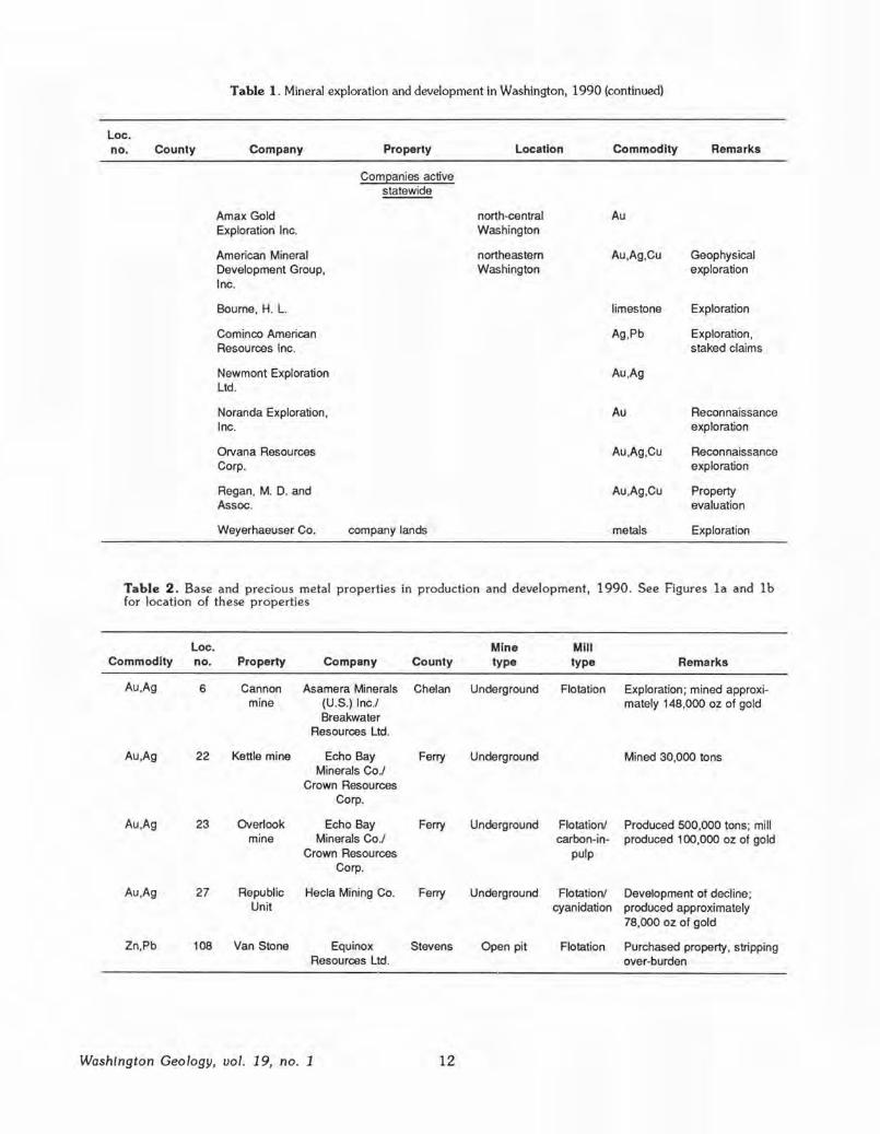
Table 1. Mineral exploration and development in Washington, 1990 (continued)
Loe. no. County Company Property Location Commodity Remarks
Comeanies active statewide
Amax Gold north-central Au Exploration Inc. Washington
American Mineral northeastern Au,Ag,Cu Geophysical Development Group, Washington exploration Inc.
Bourne, H. L. limestone Exploration
Cominco American Ag,Pb Exploration, Resources Inc. staked claims
Newmont Exploration Au ,Ag Ltd.
Noranda Exploration, Au Reconnaissance Inc. exploration
Orvana Resources Au,Ag,Cu Reconnaissance Corp. exploration
Regan, M. D. and Au ,Ag,Cu Property Assoc. evaluation
Weyerhaeuser Co. company lands metals Exploration
Table 2. Base and precious metal properties in production and development, 1990. See Figures la and lb for location of these properties
Loe. Mine Mill Commodity no. Property Company County type type Remarks
Au.Ag 6 Cannon Asamera Minerals Chelan Underground Flotation Exploration; mined approxi-mine (U.S.) Inc./ mately 148,000 oz of gold
Breakwater Resources Ltd.
Au ,Ag 22 Kettle mine Echo Bay Ferry Underground Mined 30,000 tons Minerals Co./
Crown Resources Corp.
Au .Ag 23 Overlook Echo Bay Ferry Underground Flotation/ Produced 500,000 tons; mill mine Minerals Co./ carbon-in- produced 100,000 oz of gold
Crown Resources pulp Corp.
Au.Ag 27 Republic Hecla Mining Co. Ferry Underground Flotation/ Development of decline; Unit cyanidation produced approximately
78,000 oz of gold
Zn,Pb 108 Van Stone Equinox Stevens Open pit Flotation Purchased property, stripping Resources Ltd. over-burden
Washington Geology, vol. 19, no. 1 12
en w (.) z ::> 0 C z < en ::> 0 :c I-
1980 1982 1984 1988 1988 350
300
250
200
150
100
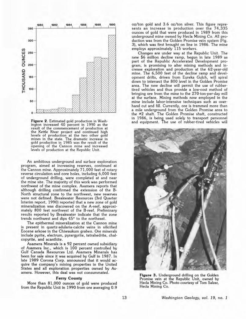
Figure 2 . Estimated gold production in Washington increased 40 percent in 1990 as the result of the commencement of production at the Kettle River project and continued high levels of production at the two other gold mines in the state. The dramatic increase in gold production in 1985 was the result of the opening of the Cannon mine and increased levels of production at the Republic Unit.
1990
An ambitious underground and surface exploration program, aimed at increasing reserves, continued at the Cannon mine. Approximately 71 ,000 feet of rotary reverse circulation and core holes, including 6,000 feet of underground drilling , were completed at and near the mine site . The majority of this work was performed northwest of the mine complex. Asamera reports that although drilling confirmed the extension of the BNorth structural zone to the northwest, new reserves were not defined. Breakwater Resources (3rd Quarter Interim report, 1990) reported that a new zone of gold mineralization was discovered on the A-reef, approximately 800 feet northwest of the B-reef . Preliminary results reported by Breakwater indicate that the zone trends northwest and dips 45° to the northeast.
The epithermal mineralization at the Cannon mine is present in quartz-adularia-calcite veins in silicified Eocene arkose in the Chiwaukum graben . Ore minerals include pyrite, electrum, pyrargyrite, tetrahedrite, chalcopyrite, and acanthite .
Asamera Minerals is a 92 percent owned subsidiary of Asamera Inc., which is 100 percent controlled by Gulf Canada Resources Ltd . Asamera Minerals has been for sale since it was acquired by Gulf in 1987 . In late 1989 Corona Corp. announced that it would acquire the company's mining properties in the United States and all exploration properties owned by Asamera. However, this deal was not consummated .
Ferry County More than 81,000 ounces of gold were produced
from the Republic Unit in 1990 from ore averaging O. 9
13
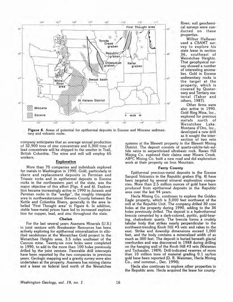
oz/ton gold and 3 .6 oz/ton silver. This figure represents an increase in production over the 74,335 ounces of gold that were produced In 1989 from this underground mine owned by Hecla Mining Co . All production was from the Golden Promise vein system (Fig . 3), which was first brought on line in 1986. The mine employs approximately 115 workers .
Changes are under way at the Republic Unit. The new $6 million decline ramp, begun in late 1989 as part of the Republic Accelerated Development program, is promising to alter mining methods and increase exploration and production at the 62-year-old mine . The 6 ,500 feet of the decline ramp and development drifts, driven from Eureka Gulch, will spiral down to intersect the 800 level in the Golden Promise area. The new decline will permit the use of rubbertired vehicles and thus provide a low-cost method of bringing ore from the mine to the 270-ton-per-day mill at the surface. Mining methods now employed in the mine include labor-intensive techniques such as overhand cut and fill. Currently, ore is trammed more than a mile underground from the Golden Promise area to the #2 shaft. The Golden Promise shaft, constructed in 1986, is being used solely to transport personnel and equipment. The use of rubber-tired vehicles will
Figure 3. Underground drilling on the Golden Promise vein at the Republic Unit, owned by Hecla Mining Co. Photo courtesy of Tom Salzar, Hecla Mining Co.
Washington Geology, uol. 19, no. 1

120° 30' 49° 00'-+------·-------,.--,-,-.,....;.,.,_,
LS COvs 117° oo'
OpC
Ks
Q Ope
LJ Eocene volcanic and sedimentary rocks
~ Jurassic-Permian volcanic and sedimentary rocks ·17° U/_.__,__ ________ _
0 SO mil~s
EXPLANATION
Mv Miocene volcanic rocks OpC Ordovician to pre-Cambrian passive Evs Eocene volcanic and sedimentary rocks margin rocks
Ks Cretaceous sedimentary rocks Ei Eocene intrusive rocks
JPvs Jurassic to Permian metasedimentary TKi Paleocene to Mesozoic intrusive and metavolcanic rocks rocks
COvs Carboniferous to Ordovician metasedi- mm High-grade metamorphic rocks mentary and metavolcanic rocks
Figure 4 . Selected metal properties plotted on a generalized geologic map of the northeastern quadrant of Washington. Letter symbols correspond to the following properties:
A, Alder Bl, Big Iron C, California CJ, Crown Jewel CM, Cannon DC, Deep Creek EC, Empire Creek EL, Elbow Lake FM, Fifteenmile FT, First Thought
GE, Golden Eagle GF, Goldfields I, Ida K, Kelsey KC, Kelly Camp KM, Kettle LF, Lamefoot LR, Lone Ranch LS, Lone Star M, Mazama
Washington Geology, uol. 19, no. 1
ME, Mount Elizabeth MG, Molson Gold MM, Manhattan Mountain MN, McNally N, Napoleon OH, Okanogan Highland OL, Overlook P, Pierre Creek PC, Poland China PO, Pend Oreille
14
RU, Republic Unit SC, Smith Canyon SL, Strawberry Lake SM, Starr Molybdenum T, Toroda TA, Talisman TM, Toulou Mountain VS, Van Stone WH, Wenatchee Heights YA, Young America 36, Sec. 36

allow increased exploration in the mine because exploration can be conducted away from the present shafts and transportation system and because muck resulting from exploration and development will not interfere with production. The Quilp shaft was also completed in 1990. The shaft provides a new ventilation system to maintain air quality in the mine . This was made necessary because diesel-powered vehicles are in use in the new decline .
The Golden Promise system consists of northeasttrending epithermal, banded chalcedony bonanza veins of Eocene age in the upper part of the Sanpoil Volcanics. Gold is present as native gold and electrum; naummanite is a major silver mineral.
Commercial production began in February 1990 at the $60 million Kettle River project, a joint venture between
Figure 5 . Mill and office complex at the Overlook mine. The mill complex was completed in 1989. Photo courtesy of Echo Bay Mining Co.
Echo Bay Minerals Co ., as the operator, and Crown Resources Corp. The precious-metal project comprises the Overlook mine, which contains the majority of the reserves, and the Kettle mine. The project produced approximately 100,000 ounces of gold during its first 10 months of operation.
The Overlook deposit, located 11 miles northeast of Republic, consists of a zone of massive magnetite, pyrite, and gold overlain by a sheeted, iron sulfide- and quartz-bearing, low-angle stockwork deposit . The gold mineralization is present in carbonate and volcaniclastic rocks of probable Permian age. Gold in the massive ore averages 0 .3 oz/ton; it averages 0 .12 oz/ton in the veined deposit in the elastic rocks (Rasmussen and Hunt, 1990).
A 7 ,800-foot decline ramp system that accommodates rubber-tired vehicles intersects several parts of the Overlook deposit. A modified room-and-pillar and room-and-rib mining system is employed at the mine . Approximately 500,000 tons of rock were mined in 1990.
The Kettle mine is located approximately a mile west of Curlew and is in an epithermal vein and breccia system in the Eocene Sanpoil Volcanics. The underground mine Is accessed by a decline ramp system. In 1990, 30,000 tons of ore were removed by shrink stope mining.
The 1,500-ton-per-day Key mill (Fig . 5) serves both the Kettle and Overlook mines and is located near the Overlook mine. Approximately 90 percent gold recovery is expected at the automated flotation mill, which uses a carbon-in-pulp vat leach system.
As of 1989, published reserves for the two mines were 3. 9 million tons of ore grading O .185 oz/ton gold. It is anticipated that 110,000 ounces of gold will be produced during the first 2 years with 85,000
15
ounces of gold being produced annually thereafter for the 7-year life of the mines . The Kettle River project employs 190 workers , making it the largest private employer in the county.
Stevens County Significant deposits of lead and zinc have not been
mined in Washington in 13 years, but that will change in 1991. Equinox Resources Ltd . purchased the Van Stone mine from Callahan Mining Company, United States Borax & Chemical Corp., and Consolidated Brinco Ltd. in April 1990. Stripping of overburden and waste rock has begun in preparation for the scheduled start-up of open-pit mining in February of 1991. The top of the bowed, cigar-shaped deposit will be mined by open-pit methods for the first 2 years; deeper parts of the deposit will then be mined for at least 6 years thereafter as a trackless underground mine accessed by two portals.
The existing infrastructure, including the l, 100-ton-per-day mill, power, water, and roads, has facilitated the rapid start-up of the mine, which was last worked in 1971 by ASARCO Inc . All necessary permitting and the construction of a new tailings dam have been completed. The $6.5 million needed for the commencement of the project has been provided by a conventional loan and by investment by a syndicate of European investors.
Yellowhead-type mineralization at the Van Stone mine is hosted by dolomite in the middle part of the Cambrian-Ordovician Metaline Formation within the contact metamorphic halo of the Cretaceous Spirit pluton. The ore body to be mined by Equinox was discovered by the former joint venture partners and lies below the orebody that was mined by ASARCO. Minable reserves of 2.5 million tons grading 5. 7 percent zinc and 1.1 percent lead have been reported by Equinox. The
Washington Geology, vol. 19, no. 1
49°
48°
47°
46°
124°
Miocene
Eocene
122°
123° 122°
121·
121°
120°
%- ,'/'/ Toroda ,., Creek
graben
120°
11a· 117°
First Thought area
Keller graben
0 MILES 40
118° 117'"
49'
47'
46°
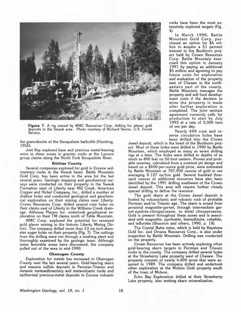
River; soil geochemical surveys were conducted on these properties.
Wilbur Hallauer used a CSAMT survey to explore his state lease in section 36 , southeast of Wenatchee Heights. That geophysical survey showed a number of interesting anomalies. Gold in Eocene sedimentary rocks is the target at the property, which Is covered by Quaternary and Tertiary material (Tabor and others, 1987).
Other firms were also active in 1990.
Figure 6 . Areas of potential for epithermal deposits in Eocene and Miocene sedimentary and volcanic rocks.
Gold Ring Mine, Inc ., explored for precious metals north of Wenatchee Lake . Montana d'Oro, Inc., developed a new drift as it sought the intersection of two vein
company anticipates that an average annual production of 32,900 tons of zinc concentrate and 5 ,300 tons of lead concentrate will be shipped to the smelter in Trail, British Columbia. The mine and mill will employ 65 workers .
Exploration
More than 70 companies and individuals explored for metals in Washington in 1990. Gold, particularly in skarn and replacement deposits in Permian and Triassic rocks and in epithermal deposits in Eocene rocks in the northeastern part of the state, was the major objective of this effort (Rgs. 4 and 6). Exploration became increasingly active in 1990 in Jurassic and Permian rocks in the "wedge", the roughly triangular area in northwesternmost Stevens County between the Kettle and Columbia Rivers, generally in the area labelled "First Thought area" in Figure 6 . In addition, stable base-metal prices have led to increased exploration for copper, lead, and zinc throughout the state .
Chelan For the last several years Asamera Minerals (U .S.)
in joint venture with Breakwater Resources has been actively exploring for epithermal mineralization in silicified sandstones at the Wenatchee Gold project in the Wenatchee Heights area , 3 .5 miles southeast of the Cannon mine. Twenty-six core holes were completed in 1990, to add to the more than 100 holes previously drilled by the joint venture . Favorable drill intercepts have been reported by the two companies in previous years. Geologic mapping and a gravity survey were also undertaken at the property. Asamera has mining claims and a lease on federal land north of the Wenatchee
Washington Geology, vol. 19, no. 1 16
systems at the Blewett property in the Blewett Mining District . The deposit consists of quartz-calcite-talc-sulfide veins in serpentinized ultrabasic rock. Raven Hill Mining Co . explored their claims near Miners Creek. AB2C Mining Co. built a new road and did exploration work at their property on Iron Mountain.
Ferry County Epithermal precious-metal deposits in the Eocene
Sanpoil Volcanics in the Republic graben (Fig . 4) have been targeted by several mineral exploration companies . More than 2 .5 million ounces of gold have been produced from epithermal deposits in the Republic area over the last 94 years .
Hecla Mining Co. continues to explore the Golden Eagle property, which is 3 ,000 feet northwest of the mill at the Republic Unit. The company drilled 30 core holes at the property during 1990, adding to the 34 holes previously drilled. The deposit is a hydrothermal breccia cemented by a dark-colored, pyritic, gold-bearing , chalcedonic quartz. The breccla forms a crudely tabular body that strikes nearly perpendicular to the northwest-trending Knob Hill #3 vein and rakes to the east. Strike and downdip dimensions exceed 1,000 feet, and the body contains a mineralized width of as much as 300 feet. The deposit is buried beneath glacial overburden and was discovered in 1988 during drilling on the hanging wall of the Knob Hill #3 vein (Waisman and Tschauder, 1989). Drill-indicated reserves of more than 10 million tons of material grading 0.1 oz/ton gold have been reported (D. R. Waisman, Hecla Mining Co., oral commun., Dec. 1990).
Hecla also continues to explore other properties in the Republic area. Hecla acquired the lease for county-

owned mineral rights under the town of Republic in 1988 .
Rotary and core drilling was done at the South Penn deposit, which is owned by a joint venture between Crown Resources Corp. and Sutton Resources Inc. Minor core drilling was also continued by these partners at the Seattle mine. Both properties contain epithermal, precious metal-bearing deposits in Eocene volcanic rocks.
Cambior USA, Inc. , as the operator, in joint venture with Crown Resources Corp. conducted reverse circulation drilling and other exploration at the 4,400-acre Mount Elizabeth property. The companies are exploring for epithermal vein mineralization in the Sanpoil Volcanics; the overlying Klondike Mountain Formation crops out on the property. The property lies between the Republic Mining District and the Kettle mine . The joint venture partners also explored for gold mineralization elsewhere in the Republic graben.
Gold Fields Mining Corp ., a new player in the Republic area , explored newly acquired ground for precious metals in Eocene volcanic rocks south of Republic . The company drilled several holes and conducted geological, geochemical, and geophysical exploration on their property north of Scatter Creek.
Echo Bay Exploration continues to explore for gold in magnetite-bearing replacement deposits in Permian metasedimentary rocks east of Republic . At the Lamefoot property, east of Curlew Lake, the company drilled 86 reverse circulation and core drill holes with encouraging results. Magnetic surveys and geologic mapping were also performed at this near-surface, massive magnetite-pyrrhotite-pyrite-bearing deposit. A second phase of drilling is scheduled for 1991. Echo Bay Minerals Co. drilled at the Lake, Oz, and Middlefork properties , also seeking gold mineralization in magnetite replacement deposits .
Inland Gold and Silver Corp. in joint venture with N. A. Degerstrom, Inc ., and Pegasus Gold Corp. continue to explore the 5,000-acre Leland property, which is located west and north of the Overlook mine . Inland Gold and Silver reported identifying three target areas on the property on the basis of geologic structur:e, alteration, and soil and rock gold geochemistry. Surface outcrop samples containing as much as O .10 oz/ton gold have been reported by Inland. Airborne and ground geophysics, as well as approximately 14,000 feet of reverse circulation drilling, have been used in their search for gold-bearing mineralization in Permian metasedimentary rocks.
Newmont Exploration Ltd. drilled targets on patented and unpatented mining claims near the California mine . The northeast-striking vein at that mine produced gold and silver intermittently prior to 1939 (Huntting, 1956). The prospect is in metasedimentary and metavolcanic rocks of Permian age (Muessig, 1967).
Kettle River Resources Ltd . assessed data previously acquired at the Empire Creek property. The company held negotiations with Cambior concerning a possible joint venture agreement on the skarn deposit along a low-angle fault zone.
Atlas Mine & Mill Supply, Inc., explored for gold in the tungsten~opper-magnetite-bearing skarn in the Kelly Camp area. Additional mining claims were
17
staked, and soil and rock samples were collected at the property.
Gold Express Inc . sought permits to renew mining and mineral processing at the Gold Mountain mine, formerly known as the Gold Dike mine. The mine, which was purchased by the company in 1988, will be operated by the 50 percent joint venture partner N. A. Degerstrom, Inc . Plans include enlarging the open-pit mine (formerly operated by Vulcan Mining Inc .) and developing an additional heap leach pad to accommodate the increased production . The deposit is a stockwork deposit in alkalic intrusive rocks of Jurassic or Eocene age; gold is associated with pyrite. Reserves at the property are reported by the company to be 500,000 tons grading 0 .065 oz/ton gold; approximately 25,000 to 30,000 ounces of gold will be recovered from the deposit over the 2-year life of the project.
Johnson Explosives used surface geologic mapping and geochemical sampling in the search for gold at the Irish claims . The property is in a nearly west-trending alkalic intrusive body, similar to that which hosts the Gold Mountain deposit.
Silver Hill Mines, Inc., explored the Talisman property through geologic investigations. The Talisman is a shallow-dipping copper-, zinc-, silver-, lead-, and tungsten-bearing skarn in gneisses of the Kettle metamorphic core complex . Base and precious metals were intermittently produced from the deposit from 1915 to 1950 (Huntting, 1956).
Kennecott Corp . drilled at the Lone Star mine . Kennecott has a lease option agreement with Wilbur Hallauer for that massive sulfide deposit, which straddles the international border.
Cyprus Minerals Co. continues to explore mining claims held by the company in the Lone Ranch Creek area . Geological, geochemical, and geophysical exploration was carried out to locate exhalative gold deposits in high-grade metamorphic rocks . South of Lone Ranch Creek, Morse Brothers examined their property through core drilling and backhoe trenching.
Other exploration activity was also recorded in Ferry County in 1990. Equinox Resources Ltd . acquired property in the Republic graben area. Pacific Houston Resources has acquired 6,500 acres of state mineral leases and staked mining claims in the county. The company explored these lands through stream-sediment sampling, using a 1 lt2-inch-diameter backpack dredge. Stewart Jackson holds claims and state mineral leases in Ferry County, several of which are leased to other companies exploring in the county.
King County CSS Management Corp. explored the Apex mine.
The deposit includes veins and breccia pipes in granodiorite of Cretaceous age. The mine is in a remote area and has had limited production in the past . CSS is a partner in Artech Recovery Systems, Inc., which was formed to finance research in the Cashman Process developed by CSS to treat ores and concentrates that have high arsenic contents in an environmentally sound manner.
Mine Evaluation, Inc., explored the Dutch Miller property near the head of the Middle Fork Snoqualmie River. The property consists of three parallel veins in
Washington Geology, vol. 19, no. 1
rocks have been the most extensively explored targets (Fig. 4).
In March 1990, Battle Mountain Gold Corp. purchased an option for $5 million to acquire a 51 percent interest in the Buckhorn project held by Crown Resources Corp. Battle Mountain exercised this option in January 1991 by paying an additional $5 million and agreeing to pay future costs for exploration and evaluation of the property east of Chesaw in the northeastern part of the county. Battle Mountain manages the property and will fund development costs if the decision to mine the property is made after further exploration is completed . The joint venture agreement currently calls for production to start by July 1993 at a rate of 3,000 tons of ore per day. Figure 7 . A rig owned by MMC Resources Corp. drilling for placer gold
deposits in the Swauk area. Photo courtesy of Richard Sterns, U.S. Forest Service . Nearly 400 core and re
verse circulation holes have been drilled into the Crown
Jewel deposit, which is the heart of the Buckhorn project. Most of these holes were drilled in 1990 by Battle Mountain, which employed as many as seven drilling rigs at a time . The holes were drilled to depths of as much as 800 feet on SO-foot centers. Proven and probable reserves , calculated from a nominal pit design and based on a $400-per-ounce gold price, were estimated by Battle Mountain at 707,000 ounces of gold in ore averaging 0 .127 oz/ton gold . Several hundred thousand ounces of additional resources have also been identified by the 1991 drilling southwest of the Crown Jewel deposit. This area will require further closely spaced drilling to define the resource.
the granodiorite of the Snoqualmie batholith (Huntting 1956). '
Joel Ray explored base and precious metal-bearing veins in shear zones in granitic rocks at the Lennox group claims along the North Fork Snoqualmie River.
Kittitas County Several companies explored for gold in Eocene sed
imentary rocks in the Swauk basin. Battle Mountain Gold Corp. has been active in the area for the last several years . Geologic mapping and geochemical surveys were conducted on their property in the Swauk Formation west of Liberty near Mill Creek. American Copper and Nickel Company, Inc ., drilled a number of shallow holes and conducted geological and geochemical exploration on their mining claims near Liberty. Crown Resources Corp. drilled several core holes on their claims east of Liberty in the Williams Creek drainage . Althouse Placers Inc . undertook geophysical exploration on their TM claims north of Table Mountain.
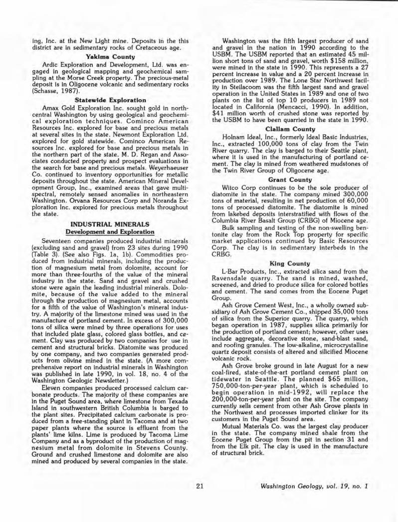
MMC Corp. explored the potential for renewed gold placer mining in the historic Liberty Mining District . The company drilled more than 53 six-inch-diameter auger holes on their property (Fig. 7) . The cuttings from the drilling were run through a washing plant and thoroughly examined by the geologic team. Although some favorable areas were discovered, the company pulled out of the area in mid-1990.
Okanogan County Exploration for metals has increased in Okanogan
County over the last several years . Gold-bearing skarn and massive sulfide deposits in Permian-Triassic and Jurassic metasedimentary and metavolcanic rocks and epithermal precious-metal deposits in Eocene volcanic
Washington Geology, uol. 19, no. 1 18
The gold skarn at the Crown Jewel deposit is hosted by volcaniclastic and volcanic rock of probable Permian and/or Triassic age. The skarn is zoned from proximal magnetite-garnet, through intermediate garnet-epidote-clinopyroxene, to distal clinopyroxene . Gold is present throughout these zones and is associated with magnetite, pyrrhotite, bismuthinite, cobaltite, and tellurides (Shannon and others, 1990, p. 18).
The Crystal Butte mine, which is held by Keystone Gold Inc . and Orvana Resources Corp., is also under inspection by Battle Mountain . Drilling was conducted on the property.
Crown Resources has been actively exploring other gold-bearing skarn targets in Permian and Triassic rocks in the county. The company drilled several holes at the Strawberry Lake property west of Chesaw. The property consists of nearly 4,000 acres that were acquired in 1989. The company drilled and undertook other exploration at the Molson Gold property south of the town of Molson.
Echo Bay Exploration drilled at their Strawberry Lake property, also seeking skarn mineralization.

FMC Gold Co. used geological and geochemical surveys to select drill targets at the Poland China mine. The mine yielded gold and silver from 1914 to 1939 from veins in the Spectacle Formation of Permian age .
Several companies explored for precious metals in Eocene volcanic rocks in the Toroda Creek graben. Cambior USA, Inc., as the operator, in joint venture with Crown Resources Corp. undertook reverse circulation drilling and geological, geophysical, and geochemical exploration at the Ida property. The epithermal, gold and silver prospect is hosted by the Sanpoil Volcanics. The joint venture partners also explored other properties in the Toroda Creek graben .
Other epithermal targets being explored in the Toroda Creek graben are in rocks that have been mapped as the Klondike Mountain Formation (Stoffel, 1990a). Approximately 6,000 feet of reverse circulation drilling was completed by Westmont Mining Inc. at the Manhattan Mountain property in Okanogan and Ferry Counties. The company is seeking epithermal, precious-metal mineralization in silicified and altered volcanic rocks. Kennecott Corp. drilled at their Toroda project, which is also near Manhattan Mountain.
Porphyry deposits in the county were investigated by several companies. Vanderbilt Go.Id Corp. in joint venture with Brenda Inc . entered into a lease option agreement with Quintana Minerals Corp. in 1989 to explore 334 unpatented mining claims near Mazama. However, the joint venture partners did not exercise their option, and Quintana is now seeking other interested parties to explore and develop the property. Eighty-two drill holes have been drilled at this lowgrade porphyry copper deposit in the Cretaceous Fawn Peak stock. Drill-indicated reserves of 149 million tons grading 0.36 percent copper and 0 .01 percent molybdenum have been reported by Quintana.
Wilbur Hallauer continues to explore the Starr Molybdenum porphyry deposit on Aeneas Mountain, 10 miles west of Tonasket. He also drilled one core hole at the Kelsey property, which is a low-grade porphyry copper and molybdenum deposit and has associated skarn mineralization (Roper, 1973).
One hole was drilled with a Winkie Drill by Wilbur Hallauer at the Cecile Creek property on the north flank of Douglas Mountain . The prospect is in the Triassic or Jurassic Loomis pluton (Stoffel, 1990b).
Base and precious metals were the target of exploration by Sunshine Valley Minerals, Inc., at the Billy Goat property. The company drilled test holes and removed overburden from prospective tunnel sites to further explore stockwork mineralization in altered volcanic rocks of Cretaceous age (Stoffel and McGroder, 1990).
ECM Inc. continued to seek partners to explore and develop mining claims near the Alder mine . The massive sulfide prospect is in the Jurassic-Cretaceous Newby Group.
Northwest Minerals Corp. explored several precious-metal targets in the county. Disseminated sulfides and precious metals in a shear zone associated with the Smith Canyon fault were the target of exploration west of Twisp at their Smith Canyon property. Geologic mapping and geochemical sampling were undertaken at that prospect. Gold-bearing fault-controlled veins in
19
metasedimentary rocks of the Permian Anarchist Group were explored by Northwest at the Okanogan Highgrade property near Tonasket. Underground and surface sampling and geologic mapping were undertaken to determine the extent of disseminated mineralization and mercury veins on the property. At the Red Shirt prospect, geological mapping and rock geochemistry were used to examine veins in a shear zone in altered Cretaceous-Jurassic gabbros along the Red Shirt thrust . The Red Shirt mine has been idle since 1938 (Huntting, 1956).
Geological mapping and geochemical sampling were conducted at the Turtle Lake property held by L. F. Baum Associates. The property is a stockwork and strata-bound volcanic-rock-hosted deposit.
The Geology Department of the Colville Confederated Tribes (written commun ., 1990) reported that they have identified elevated gold values in a zone 80 feet wide that extends 400 feet along strike near the headwaters of Parmenter Creek on the Colville Indian Reservation. Samples collected by the Geology Department contained gold values as high as 0.44 oz/ton. A heavy-mineral stream-sediment survey conducted by a mineral permittee in 1989 on the reservation in the Republic and Keller grabens indicated anomalous gold values at several locations.
Pend Oreille County Resource finance Inc . (RFI), which is 44 percent
owned by Kerr Addison Mines Ltd ., purchased the Pend Oreille mine for $1.25 million in mid-1990 from Pintlar Corp., a wholly owned subsidiary of Gulf Resources Corp. The former lead-zinc producer was last active in 1977. A major drilling program is under way at the mine to evaluate the strata-bound ores in the Yellowhead zone in the dolomite unit of the CambrianOrdovician Metaline Formation . Fifty-four underground holes were drilled in 1990 to enhance reserve information . Published drill-indicated reserves are 3.7 million tons grading 8.8 percent zinc and 1.6 percent lead over a thickness of 17 feet.
In the future Kerr Addison will be playing a more active role in exploration and development at the mine . Financial and management assistance from Kerr Addison will enable RFI to retain its 100 percent interest in the property and raise the $3 million to $5 million needed for further exploration.
Raven Hill Mining Co. has explored two properties in the county. Surface exploration continued at the Cooks Copper property where silver and copper mineralization was the target. Development at the Glass mine included laying track, building ramps, and continuing dewatering. The base- and precious-metal property Is the Precambrian Prichard Formation.
Pierce County Nerco Exploration Co. drilled nine reverse circula
tion holes totaling more than 2 ,800 feet at the Carbon River property and then returned the property to the owner, Mark Wagner. The deposit is on the periphery of a gold-copper-tourmaline-bearing breccia pipe at the contact of the Miocene Carbon River stock and andesite of Miocene age . Drilling, which had some encouraging results, was performed between two mineralized outcrops that are approximately 3 ,000 feet apart.
Washington Geology, vol. 19, no. 1

Skamania County Core drilling was undertaken by Plexus Resources
Corp. at the Silver Star property to better define the mineralization in the Blackjack breccia pipe. The company reports reserves at the porphyry deposit are 2. 9 million tons grading 1.62 percent copper, 0 .035 percent molybdenum, and 0.35 oz/ton silver.
Operations at the Wind River mine in the St. Helens District near Carson were on hold for most of the year.
Snohomish County Island-Arc Resources Corp ., as the operator, in
joint venture with Formosa Resources Corp. drilled nine shallow vertical and inclined core holes at the Lockwood property in the Sultan basin. Kennecott offered to perform an electromagnetic survey on the property to acquire a right to negotiate a 51 percent interest in the near surface polymetallic volcanogenic banded massive sulfide deposit.
The 45 mine was explored by Mine Evaluation, Inc. This deposit in Paleocene to Cretaceous metasedimentary and metavolcanic rocks is a past producer of gold and silver (Derkey and others, 1990).
Stevens County The area of the most increased exploration activity
in the state is the "wedge" in the northwestern part of the county. Exploration has been concentrated on precious-metal deposits In Eocene volcanic rocks and polymetallic deposits in Permian, Triassic, and Jurassic metasedimentary and metavolcanic rocks.
Boise Cascade Corp. in joint venture with Pathfinder Gold Corp. has been active in the wedge area for several years and increased their exploration activity in 1990. The joint venture partners explored for epithermal gold and silver in Eocene volcanic rocks at the First Thought mine . Four surface core holes were drilled at the property in the Sanpoil Volcanics.
In addition, ten reverse circulation holes and a core hole were drilled by these joint venture partners at the McNally property. The skarn deposit is in limestone of probable Permian or Triassic age that is approximately 100 feet thick and more than 1,000 feet in length .
The joint venture partners have also staked claims and leased property that covers 10 square miles from Limestone Creek to Flat Creek. This area includes the Easter Sunday and the Big Iron mines . The Big Iron was a producer of magnetite ore from 1924 to 1937; the ore was reported to carry $3 to $4 in gold per ton (Broughton, 1945). Reconnaissance exploration for gold-bearing replacement deposits in Permian metasedimentary rocks was also implemented by the joint venture partners .
Placer Dome US Inc. staked numerous claims in the vicinity of the Big Iron mine.
Exploration was continued by Boise Cascade and Pathfinder Gold on the massive gold-iron veins at the Fifteen Mile Creek property. Geological mapping and geochemical sampling were also undertaken at the Gold Hill property north of Kettle Falls, where veins and stockwork cut a Tertiary dike that intrudes Permian metasedimentary rocks. Massive iron-gold mineralization in metasedimentary rocks of probable Permian age
Washington Geology, vol. 19, no. 1 20
was the target of geochemical sampling by these companies at the Toulou Mountain property.
Echo Bay Exploration joined those exploring for precious metals in the "wedge" area. The company drilled in the Fifteen Mile area seeking massive goldiron-bearing veins in the Jurassic Rossland Formation . At the Pierre Creek property Echo Bay drilled at least four holes seeking gold mineralization in Permian metasedimentary rocks. The property includes the Copper Penny claims .
Three reverse circulation drill holes were completed by Battle Mountain Gold Corp. at the Elbow Lake property . Geologic mapping and geochemical sampling were also impl<?mented in the search for gold mineralization in pyrite-bearing Permian metasedimentary rocks at this property.
Kennecott Corp. signed an option agreement to acquire the Napoleon mine . The gold-bearing contact metamorphic deposit is in Permian to Triassic metasedimentary rocks . The mine last produced in 1955, and the ore was reported to contain 0 .05 to 0.1 ounce of gold per ton (Huntting, 1956).
Eagle Lake Exploration Ltd . completed a geochemical and induced polarization survey over areas of known skarn mineralization at the Kelly Hill property to define drill targets .
Silver Hill Mines, Inc ., purchased the Young America mine in August. The former base- and preciousmetal producer is in limestone of Permian age (Stoffel, 1990a).
A. Ambrose continued placer mining in Sheep Creek.
Lead and zinc mineralization in the Metaline Formation is the focus of exploration by Bitteroot Resources Ltd . The company, which is 52 percent owned by Equinox Resources, controls the Advance , Calhoun, Deep Creek, HC, Iroquois, Scandia, and Sherlock properties. (These properties were formerly held by Mines Management, Inc.) In addition, 8,000 acres were acquired from Washington Resources Partnership and Grandview Mining Co.; the company has also acquired the option to purchase the Grandview mine . Bitteroot has entered into an agreement with Northport Minerals Ltd. whereby Northport can option as much as a 60 percent interest in the company's holdings in the Northport area. Northport Minerals owns the 1,500-ton-per-day Calhoun mill, which is located near the properties held by Bitteroot.
Leadpoint Consolidated Mines Co. did surface trenching to facilitate geological exploration at their property in the Northport Mining District. Lead, zinc, and silver mineralization was the focus of this exploration.
Whatcom County The Excelsior mine, which has been explored by
Steelhead Gold Inc. since 1984, has been returned to the owner, who is now seeking new parties to proceed with the project. The gold deposit, which was last mined in 1916, Is contained In a series of sedimentary and volcanic rocks of the Jurassic Wells Formation.
Several companies were active in the Slate Creek Mining District. Seattle-St. Louis Mining Co. continued exploration of the vein system at the Minnesota mine. Surface sampling was continued by Western Gold Min-
ing, Inc. at the New Light mine. Deposits in the this district are in sedimentary rocks of Cretaceous age .
Yakima County Ardic Exploration and Development, Ltd. was en
gaged in geological mapping and geochemical sampling at the Morse Creek property. The precious-metal deposit is in Oligocene volcanic and sedimentary rocks (Schasse, 1987).
Statewide Exploration Amax Gold Exploration Inc. sought gold in north
central Washington by using geological and geochemical exploration techniques . Cominco American Resources Inc. explored for base and precious metals at several sites in the state . Newmont Exploration Ltd. explored for gold statewide. Cominco American Resources Inc. explored for base and precious metals in the northern part of the state. M. D. Regan and Associates conducted property and prospect evaluations in the search for base and precious metals. Weyerhaeuser Co. continued to inventory opportunities for metallic deposits throughout the state . American Mineral Development Group, Inc., examined areas that gave multispectral, remotely sensed anomalies in northeastern Washington. Orvana Resources Corp and Noranda Exploration Inc. explored for precious metals throughout the state.
INDUSTRIAL MINERALS Development and Exploration
Seventeen companies produced industrial minerals (excluding sand and gravel) from 23 sites during 1990 (Table 3). (See also Figs . la , lb) . Commodities produced from industrial minerals, including the production of magnesium metal from dolomite, account for more than three-fourths of the value of the mineral industry in the state. Sand and gravel and crushed stone were again the leading industrial minerals. Dolomite, because of the value added to the mineral through the production of magnesium metal, accounts for a fifth of the value of Washington's mineral industry. A majority of the limestone mined was used in the manufacture of portland cement. In excess of 300,000 tons of silica were mined by three operations for uses that included plate glass, colored glass bottles, and cement. Clay was produced by two companies for use in cement and structural bricks. Diatomite was produced by one company, and two companies generated products from olivine mined in the state. (A more comprehensive report on industrial minerals in Washington was published in late 1990, in vol. 18, no. 4 of the Washington Geologic Newsletter.)
Eleven companies produced processed calcium carbonate products. The majority of these companies are in the Puget Sound area, where limestone from Texada Island in southwestern British Columbia is barged to the plant sites. Precipitated calcium carbonate is produced from a free-standing plant in Tacoma and at two paper plants where the source is effluent from the plants' lime kilns . Lime is produced by Tacoma Lime Company and as a byproduct of the production of magnesium metal from dolomite in Stevens County. Ground and crushed limestone and dolomite are also mined and produced by several companies in the state.
21
Washington was the fifth largest producer of sand and gravel in the nation in 1990 according to the USBM. The USBM reported that an estimated 45 million short tons of sand and gravel, worth $158 million, were mined in the state in 1990. This represents a 27 percent increase in value and a 20 percent increase in production over 1989. The Lone Star Northwest facility in Steilacoom was the fifth largest sand and gravel operation in the United States in 1989 and one of two plants on the list of top 10 producers in 1989 not located in California (Mencacci, 1990). In addition, $41 million worth of crushed stone was reported by the USBM to have been quarried in the state in 1990.
Clallam County Holnam Ideal, Inc., formerly Ideal Basic Industries,
Inc., extracted 100,000 tons of clay from the Twin River quarry. The clay is barged to their Seattle plant, where it is used in the manufacturing of portland cement. The clay is mined from weathered mudstones of the Twin River Group of Oligocene age.
Grant County Witco Corp continues to be the sole producer of
diatomite in the state . The company mined 300,000 tons of material, resulting in net production of 60,000 tons of processed diatomite . The diatomite is mined from lakebed deposits interstratified with flows of the Columbia River Basalt Group (CRBG) of Miocene age .
Bulk sampling and testing of the non-swelling bentonite clay from the Rock Top property for specific market applications continued by Basic Resources Corp . The clay is in sedimentary interbeds in the CRBG.
King County L-Bar Products, Inc ., extracted silica sand from the
Ravensdale quarry . The sand is mined, washed , screened, and dried to produce silica for colored bottles and cement. The sand comes from the Eocene Puget Group.
Ash Grove Cement West, Inc., a wholly owned subsidiary of Ash Grove Cement Co., shipped 35,000 tons of silica from the Superior quarry . The quarry, which began operation in 1987, supplies silica primarily for the production of portland cement; however, other uses include aggregate, decorative stone, sand-blast sand, and roofing granules . The low-alkaline, microcrystalline quartz deposit consists of altered and silicified Miocene volcanic rock.
Ash Grove broke ground in late August for a new coal-fired, state-of-the-art portland cement plant on tidewater in Seattle. The planned $65 million, 750,000-ton-per-year plant, which is scheduled to begin operation in mid-1992, will replace the 200,000-ton-per-year plant on the site. The company currently sells cement from other Ash Grove plants in the Northwest and processes imported clinker for its customers in the Puget Sound area.
Mutual Materials Co. was the largest clay producer in the state . The company mined shale from the Eocene Puget Group from the pit in section 31 and from the Elk pit . The clay is used in the manufacture of structural brick.
Washington Geology, uol. 19, no. 1
Table 3. Properties properties)
producing industrial minerals in 1990 (See Figures la and lb for location of these
Loe. Commodity no. Property Company County Remarks
clay 12 Twin River Holnam Ideal, Inc. Clallam Mining quarry
clay 83 Clay City pit Mutual Materials Co. Pierce Mining
clay 47 Elk pit Mutual Materials Co. King Mining
clay 90 Mica mine Mutual Materials Co. Spokane Mined 136,000 tons
clay 48 Sec. 31 Mutual Materials Co. King Mining
diatomite 41 Sec. 3/10 pit Witco Corp. Grant Mining
diatomite 39 Sec. 7 pit Witco Corp. Grant Mining
diatomite 40 Sec. 8 pit Witco Corp. Grant Mining
dolomite 104 Chewelah Chewelah Eagle Mining Co. Stevens Mining Eagle group
dolomite 113 Several Nanome Aggregates, Inc. Stevens Purchased by quarries Meridian Minerals
dolomite 116 Addy Northwest Alloys, Inc. Stevens Mined 500,000 tons Dolomite quarry
dolomite 74 Brown quarry Pacific Calcium, Inc. Okanogan Mining
limestone 58 Wauconda Columbia River Carbonates Okanogan Mining and crushing quarry
limestone 78 Champane Lafarge Corp. Pend Mining; closed cement Placer Oreille plant
limestone 114 Sherve Northport Limestone Co. Stevens Mined 25,000 tons quarry (subsidiary of Hemphill
Brothers, Inc.)
limestone 75 Tonasket Pacific Calcium, Inc. Okanogan Mining and milling Limestone quarry
limestone 123 Kendall Tilbury Cement Co. Whatcom Mined 16,000 tons quarry
olivine 85 AIMCOR Applied Industrial Materials Skagit Producing olivine Olivine Corp. products
olivine 120 Swen Larsen Olivine Corp. Whatcom Mining quarry
quartz xis 44 Spruce claim Robert Jackson King Mining
silica 42 Superior Ash Grove Cement West, Inc. King Shipped 35,000 tons quarry from stockpile
silica 111 Lane Lane Mountain Silica Co. Stevens Mined 300,000 tons Mountain (subsidiary of Hemphill Silica Brothers, Inc.)
silica 45 Ravensdale L-Bar Products, Inc. King Mining pit
Washington Geology, vol. 19, no. 1 22

Quartz crystals and quartz crystals with pyrite were extracted from the Spruce claim by Robert Jackson. Many of these crystals are of museum quality.
Okanogan County Columbia River Carbonates, a limited partnership
of Bleek Management, Inc. and Genstar Carbonates, Inc., mined and crushed white, high-brightness, highcalcium carbonate marble at their Wauconda quarry. The marble is sent by rail to the Columbia River Carbonates plant at Woodland, near Vancouver, where it is ground to produce several grades of fine and ultrafine powder and slurry.
Pacific Calcium, Inc., continues to mine high-calcium limestone from the Tonasket Limestone quarry and dolomite from the Brown quarry near Riverside. The carbonates are crushed in Tonasket and sold as poultry feed, soil amendment, and a lawn-care product.
Sunshine Valley Minerals, Inc., explored for silica at the Hoffman property in the Aeneas Valley.
Pend Oreille County In August of 1989, Lafarge Corp. purchased the
portland cement plant in Metaline Falls and three distribution terminals from Lehigh Portland Cement Co. for nearly $7 .5 million. Lafarge, the second largest cement manufacturer in the country in 1989, then closed the plant in June 1990, citing higher-than-expected capital costs to modernize the SO-year-old facility. The operation employed approximately 60 workers and was a major employer in the northern part of the county.
Southern Talc Co., as the operator, in joint venture with Arst Miss Gold Inc. continued exploration at their Totem Talc property. The deposit is in a shear zone in the Precambrian Z Monk Formation. Non-asbestosbearing talc in the county has also been the target of several companies.
Pierce County Mutual Materials Co. mined clay from altered
Eocene volcanic rocks at the Clay City pit. The clay is used to make structural brick.
Skagit County Applied Industrial Materials Corp . (AIMCOR)
crushed and screened olivine purchased from Olivine Corp. The company produces olivine flour for use as foundry and blast sands.
Spokane County Structural bricks have been produced at a mine near
Mica since 1893. Mutual Materials Co. purchased the mine and plant from Interpace Industries Inc. of Kirkland in mid-1990. The company expanded a section of the north pit, resulting in development of white clay reserves, and mined a 2-year, 136,000-ton supply of clay. The company employs 80 people and processes 15 to 20 tons of clay per day. Nearly 50 million offwhite and colored structural and decorative bricks are manufactured by this company each year.
Steven• County Northwest Alloys, Inc., a wholly owned subsidiary
of Aluminum Co. of America, mined approximately 500,000 tons of material from the Addy Dolomite quarry; this represents a decrease from the tonnage
23
mined in 1989. Northwest Alloys' mine and plant at Addy is the mineral operation having the highest value in the state because of the value added to the dolomite by the production of magnesium metal. The company is one of only three producers of magnesium metal in the United States. The plant, which operated at less than full capacity in 1990, is the largest private employer in Stevens County.
White and colored dolomite was mined and processed by several companies. Nanome Aggregates, Inc., selectively mines dolomite from several quarries in the county to produce white and various colors of architectural aggregate . The company was purchased by Meridian Minerals Co. in mid-1990. Meridian plans to improve the quality of the raw materials and upgrade the plant facility. Chewelah Eagle Mining Co. improved the access road to their quarry near Eagle Mountain; the company extracted dolomite to fulfill a contract to Nanome.
The Jann! Limestone quarry, owned by Peter Janni and Sons, is leased to Pluess-Staufer Industries, Inc.
Hemphill Brothers, Inc. continues to operate two industrial mineral properties in the county. Lane Mountain Silica Co., the largest silica producer in the state, produced 300,000 tons of high-grade silica from a friable area of Addy Quartzite.
Northport Limestone Co. mined, crushed, and screened 25,000 tons of metallurgical-grade limestone at the Sherve quarry south of Northport. The limestone is sold for flux to the Cominco Ltd. smelter in Trail, British Columbia.
Whatcom County Olivine Corp. continues to mine fresh, unaltered
olivine from the Swen Larsen quarry in the Twin Sisters dunite. The rock is sold to AIMCOR and is used by Olivine Corp. in the fabrication of modular olivine refractory slabs for waste incinerators which were pioneered by the company.
Tilbury Cement Co. of Delta, British Columbia, mined a minor amount of limestone and shale from the Kendall quarry. The company purchased the quarry and cement plant in Bellingham from Columbia Northwest Cement Corp. in 1987 and then drastically curtailed operations.
REFERENCES CITED Broughton, W. A., 1945, Some magrietite deposits of Ste
vens and Okanogan Counties, Washington: Washington Division of Geology Report of Investigations 14, 24 p., 5 pl.
Derkey, R. E.; Joseph, N. L; Lasmanis, Raymond, 1990, Metal Mines of Washington-Preliminary report: Washington Division of Geology and Earth Resources Open File Report 90-18, 577 p.
Huntting, M. T., 1956, Inventory of Washington minerals-Part II, Metallic minerals: Washington Division of Mines and Geology Bulletin 37, v. 1, 428 p.; v. 2, 67 p .
Mencacci, M. C., 1990, Top U.S. sand and gravel plants: Rock Products, v. 93, no. 6, p. 28-33.
Muessig, Siefgried, 1967, Geology of the Republic quadrangle and a part of the Aeneas quadrangle, Ferry County, Washington: U.S. Geological Survey Bulletin 1216, 135 p., 1 pl.
Washington Geology, vol. 19, no. 1

Rasmussen, Mike; Hunt, Walt, 1990, Geology and origin of the Overlook gold deposit, northeastern Washington [abstract] : Northwest Mining Association, 96th Annual Convention Abstract Booklet, p. 18.
Roper, M. W., 197 3, Geology of the Kelsey copper-molybdenum property, Okanogan County, Washington: Montana State University Master of Science thesis, 97 p., 5 pl.
Schasse, H. W., compiler, 1987, Geologic map of the Mount Rainier quadrangle, Washington: Washington Division of Geology and Earth Resources Open File Report 87-16, 43 p., 1 pl., scale 1:100,000.
Shannon, J. R.; Drinkard, M. J.; Miller, R. E.; Christensen, T.; Stiles, C. A., 1990, Geology of the Crown Jewel deposit, Buckhorn Mountain, Okanogan County, Washington [abstract]: Northwest Mining Association, 96th Annual Convention Abstract Booklet, p. 18.
Stoffel, K. L., compiler, 1990a, Geologic map of the Republic 1: 100,000 quadrangle, Washington: Washington Division of Geology and Earth Resources Open File Report 90-10, 62 p., 1 pl.
Stoffel, K. L., compiler, 1990b, Geologic map of the Oroville 1: 100,000 quadrangle, Washington: Washington Division of Geology and Earth Resources Open File Report 90-11, 58 p., 1 pl.
Stoffel, K. L.; McGroder, M., F., compilers, 1990, Geologic map of the Robinson Mtn. 1:100,000 quadrangle, Washington : Washington Division of Geology and Earth Resources Open File Report 90-5, 39 p., 1 pl.
Tabor, R. W.; Frizzell, V. A., Jr.; Whetten, J. T.; Waitt, R. B.; Swanson, 0. A.; Byerly, G. R.; Booth, D. B.; Hetherington, M. J .; Zartman, R. E., 1987, Geologic map of the Chelan 30-minute by 60 minute quadrangle, Washington: U.S. Geological Survey Miscellaneous Investigations Series Map 1-1661, 1 sheet, scale 1:100,000, with 29-p. text.
Waisman, D. R.; Tschauder, R. J ., 1990, The Golden Eagle deposit, Republic, Washington [abstract]: Northwest Mining Association, 96th Annual Convention Abstract Booklet, p. 18.
Staff Notes Bill Phllllps left OGER at the end of December to
begin studies for a Ph . D. Bill was Section Head in our Geology and Resources Section and had responsibility for coordinating the geologic aspects of the northeast quadrant of the new 1 : 250, 000-scale state map . He also compiled the geology and prepared text for several 1 : 100, 000-scale quadrangles in northwest and southwest quadrants . Bill wrote a number of articles about volcanic and sedimentary rocks and coal in southwestern Washington and regional gravity surveys of the Cascade Range.
Beginning in March, Keith Stoffel (facing page) will be working for the Department of Ecology as a hydrogeologist in the solid and hazardous waste program in the department's Eastern Region office in Spokane . Keith joined OGER in June 197 8 as a Geologist 2. Recently, he l\as been the driving force in preparation of the geologic map of the northeast quadrant of Washington . He compiled the 100,000-scale maps for
Washington Geology, vol. 19, no. 1 24
the Oroville, Robinson Mtn. (with M. F. McGroder) and Republic quadrangles and has had major responsibility for completion of the 1:250,000-scale product, to be released in 1991 in our Geologic Map series.
Bill Phillips

Josh Logan (left) and Keith Stoffel
Josh Logan (above) has been promoted to Geologist 4, Section Head for the Division's Geology and Resources Section. Josh's responsibilities will now include overseeing preparation of the 1: 100, 000- and 1: 250, 000-scale geologic maps of the state's northwest quadrant for the state geologic map project. He will continue to investigate landslide-dammed lakes in Washington, but will be relinquishing his work with the Timber, Fish, and Wildlife program.
Nancy Joseph (right) has left our staff for a position as a Geologist 4, Economic Geology Specialist, with the Division of Lands and Minerals, where she will manage the mineral leasing program. Nancy started work with DGER in mid-1985 as a Geologist 2 with a specialty in economic geology. Recently she has been involved with compilation of the northeast quadrant of the new state geologic map, for which she compiled the geology of the Colville, Nespelem, and Spokane quadrangles. She has also prepared annual summaries and other articles about the mineral industry in Washington.
25
Carolyn Michal left us in February; she has decided to return to school. She joined us as a temporary clerk In August 1990 and was a mainstay in maintaining our supply of open-file reports.
Jo Roller has taken a position as Administrative Assistant 4 with the Department of Fisheries. Jo came to us last August and served our Division as Office Manager.
In mid-February, Barbara Preston accepted the position of Administrative Assistant 2 (Developmental) to replace Jo Roller.
Shelley Reisher has come to us from the Department of Social and Health Services to be our new Clerk Typist 2. She replaces Carolyn Michal.
Nancy Joseph
Washington Geology, vol. 19, no. 1

Coal Activity in Washington during 1990 by Henry W. Schasse
Activity In the coal industry remains limited to mining at the state's two producing coal mines. Total coal production at those mines was slightly above 5 million tons for 1990. There was no exploration for new coal deposits in Washington in 1990.
Pacific Coast Coal Co ., Inc. (PCCC), operator of the John Henry No . 1 open-pit coal mine in the Green River Coal District east of Black Diamond (Fig. 1), brought its new beneficiation plant on line in November of 1990. After some minor delays while working out problems in fine tuning the 150-tons-per-hour, onsite plant, the company has now achieved the full rate of production .
In 1990, PCCC saw production at the mine increase by 10.4 percent, from 115,416 short tons in 1989 to 127,458 tons in 1990. Eighty-four percent of the 1990 production was exported to Japan and Korea to be used at cement plants and for electrical power generation . Lesser amounts of coal were used by several public institutions in the Puget Sound area to fuel their heating plants (9%) and to test coal blends de-
Glacier Peak•
~ :t· ... t:· ; ; Seattle .•.. { .;!O Green River ~; G .;.,::, / Coal District · ;, , ...;;;;;:,
signed to meet future federal emission standards at the Centralia Steam plant (6%) . A minor amount was sold for residential heating. PCCC hopes to increase its production to the mine's full design capacity of 250,000 tons per year during 1991, now that it has its on-site beneficiation plant operating at full capacity. PCCC mines bituminous coal from coal seams of the Franklin coal series (Franklin Nos. 7, 8, 9, and 10), which are stratigraphically near the base of the Eocene Puget Group in nonmarine deltaic sedimentary rocks (Rg. 2).
PCCC is also considering co-use of the John Henry mine for disposal of construction demolition material. The company will be submitting permit applications to county and federal authorities and will have an environmental impact statement prepared sometime this year.
During 1990, a change in ownership took place at the state's largest coal mine, the Centralia Coal Mine, which is located in the Centralia Coal District near Centralia (Fig. 1). Centralia Mining Co ., a subsidiary of PacificCorp, is the new operator of the mine. Wash-
ington Irrigation and Development Company (WIDCO) had been the mine operator since the start of production in 1971 .
Coal production at the Centralia Coal Mine during 1990 totalled 4,873,801 clean short tons; this was 24,000 tons less than was produced during 1989. The coal mined at Centralia came from eleven beds representing six coal seams and splits of three of the seams. The subbltuminous coal is in the middle of the Skookumchuck Formation, a near-shore and nonmarine unit and an upper member of the Puget Group. The mine is the sole supplier of the Centralia Steam Plant . .-:: 1;) JOHN HENRY
,•·/' t , . .,, NO. 1 MINE .~.'T lack C....,
... . .:.: acoma Diamond ;;.·l
The mine has produced an average of 4.2 million tons annually over the past 20 years of its operation.
47°
t North
46°
~~.~~· A ~· Olyr~;pi~ . ~ENTRALIA J.:.i_:.J
d 1 •Mt. Rainier Q.~ .5'$;';,< COAL {A
Centrella- f(jyf'· a MINr w Chehalls'°''"".°"'"'-\:. ~ .. ~::::I
Coal District ""ti (::;::<
0 25 Miles
Major coal-bearing areas of Washington
124°
\;::;I
123°
0
•Mt. St. Helens
Figure 1 . Active coal-producing areas and districts, western Washington.
Washington Geology, vol. 19, no. 1 26
WIDCO Waste Services (WSS), a sister company to WIDCO, terminated its plans for a 50-million-ton regional municipal solid-waste landfill that would have involved two pits located on 600 acres at the Centralia Coal Mine (Schasse, 1990). Permit delays and questions about the stability of the site prompted WWS to scrap the $47-million project near Bucoda (The Olympian, Dec. 20, 1990).
Reference Cited
Schasse, H. W., 1990, Coal activity in Washington in 1989: Washington Geologic Newsletter, v. 18, no. 1, p . 24-25.
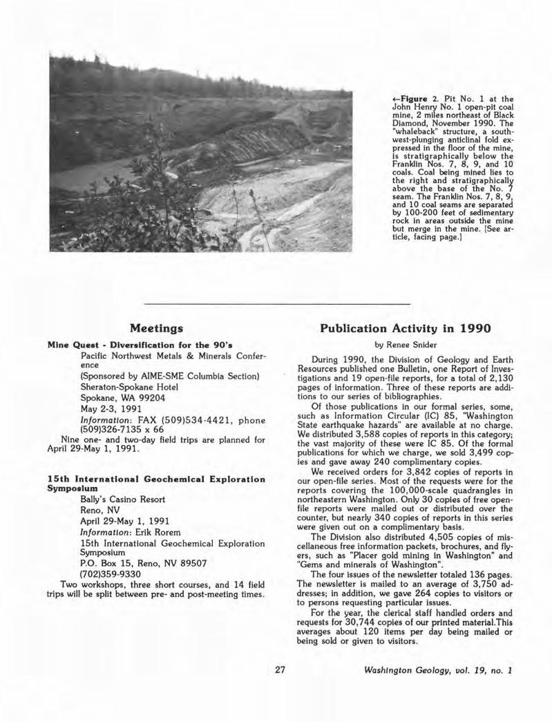
Meetings Mine Quest · Diversification for the 90's
Pacific Northwest Metals & Minerals Conference (Sponsored by AIME-SME Columbia Section) Sheraton-Spokane Hotel Spokane, VJA 99204 May 2-3, 1991 Information : FAX (509)534 -4421, phone (509)326-7135 X 66
Nine one- and two-day field trips are planned for April 29-May 1, 1991.
15th International Geochemical Exploration Symposium
Baily's Casino Resort Reno, NV April 29-May 1, 1991 Information : Erik Rorem 15th International Geochemical Exploration Symposium P.O. Box 15, Reno, NV 89507 (702)359-9330
Two workshops, three short courses, and 14 field trips will be split between pre- and post-meeting times.
27
~Figure 2. Pit No. 1 at the John Henry No. 1 open-pit coal mine, 2 miles northeast of Black Diamond, November 1990. The "whaleback" structure, a southwest-plunging anticlinal fold expressed in the floor of the mine, is stratigraphically below the Franklin Nos. 7, 8, 9, and 10 coals. Coal being mined lies to the right and stratigraphically above the base of the No. 7 seam. The Franklin Nos. 7, 8, 9, and 10 coal seams are separated by 100-200 feet of sedimentary rock in areas outside the mine but merge in the mine. [See article, facing page.)
Publication Activity in 1990 by Renee Snider
During 1990, the Division of Geology and Earth Resources published one Bulletin , one Report of Investigations and 19 open-file reports, for a total of 2,130 pages of information . Three of these reports are additions to our series of bibliographies.
Of those publications in our formal series, some, such as Information Circular (IC) 85, 'Washington State earthquake hazards" are available at no charge . VJe distributed 3,588 copies of reports in this category; the vast majority of these were IC 85. Of the formal publications for which we charge, we sold 3,499 copies and gave away 240 complimentary copies.
VJe received orders for 3,842 copies of reports in our open-file series . Most of the requests were for the reports covering the 100, 000-scale quadrangles in northeastern VJashington . Only 30 copies of free openfile reports were mailed out or distributed over the counter, but nearly 340 copies of reports in this series were given out on a compHmentary basis.
The Division also distributed 4,505 copies of miscellaneous free information packets, brochures, and flyers, such as "Placer gold mining in VJashington" and "Gems and minerals of VJashington".
The four issues of the newsletter totaled 136 pages. The newsletter is mailed to an average of 3,750 addresses; in addition, we gave 264 copies to visitors or to persons requesting particular issues.
For the year, the clerical staff handled orders and requests for 30,744 copies of our printed material. This averages about 120 items per day being mailed or being sold or given to visitors .
Washington Geology, uol. 19, no. 1
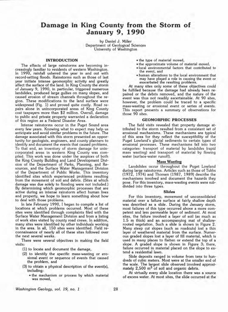
Damage in King County from the Storm of January 9, 1990
by Daniel J . Miller Department of Geological Sciences
University of Washington
INTRODUCTION The effects of large rainstorms are becoming in
creasingly familiar to residents of western Washington . In 1990, rainfall ushered the year in and out with record-setting floods . Rainstorms such as those of last year initiate intense geomorphic activity and greatly affect the surface of the land . In King County the storm of January 9, 1990, in particular, triggered numerous landslides, produced large gullies on many slopes, and caused erosion of stream channels throughout the region . These modifications to the land surface were widespread (Fig. 1) and proved quite costly. Road repairs alone in unincorporated areas of King County cost taxpayers more than $2 million . Overall, damage to public and private property warranted a declaration of this region as a Federal Disaster Area .
Intense rainstorms occur in the Puget Sound area every few years. Knowing what to expect may help us anticipate and avoid similar problems in the future. The damage associated with this storm presented an opportunity for geologists, engineers, and county planners to identify and document the events that caused problems . To that end, an inventory of storm damage for unincorporated areas in western King County was compiled . This work was done under the auspices of both the King County Building and Land Development Division of the Department of Parks, Planning, and Resources, and the Surface Water Management Division of the Department of Public Works . This inventory identified sites which experienced problems resulting from the movement of soil and debris. (Sites at which damage was due solely to flooding were not included.) By determining which geomorphic processes that are active during an intense rainstorm affect human lives and property, we hope to learn something about how to deal with those problems .
In late February 1990, I began to compile a list of locations at which problems occurred. Most of these sites were identified through complaints filed with the Surface Water Management Division and from a listing of work sites visited by county road crews. In addition, many sites were identified by other individuals working in the area . In all, 150 sites were identified. Field reconnaissance of nearly all of these sites followed over the next several weeks .
There were several objectives in making the field visits:
(1) to locate and document the damage, (2) to identify the specific mass-wasting or ero
sional event or sequence of events that caused the problem, and
(3) to obtain a physical description of the event(s), Including: • the mechanism or process by which material
was moved,
Washington Geology, vol. 19, no. 1 28
• the type of material moved, • the approximate volume of material moved, • local environmental factors that contributed to
the event, and • human alterations to the local environment that
may have played a role in causing the event or exacerbated the resulting problems.
At many sites only some of these objectives could be fulfilled because the damage had already been repaired or the debris removed, and the nature of the event was thus not readily ascertainable. At 90 sites, however, the problem could be traced to a specific mass-wasting or erosional event or series of events. This report presents a summary of observations for those 90 sites .
GEOMORPHIC PROCESSES The field visits revealed that property damage at
tributed to the storm resulted from a consistent set of erosional mechanisms. These mechanisms are typical of this area for they reflect the susceptibility of the Puget Lowland's glacial sediments to certain types of erosional processes. These mechanisms fall into two categories : transport of material by landslides (rapid mass wasting) and transport of material by flowing water (surface-water runoff) .
Mass Wasting Landslides occur throughout the Puget Lowland
during large rainstorms. Articles such as those of Tubbs (1972, 1974) and Thorsen (1987, 1989) describe the mechanisms involved and document the hazards they pose. For this inventory, mass-wasting events were subdivided into three types.
Slides For this inventory, movement of unconsolidated
material over a failure surface at fairly shallow depth was described as a slide . During the January storm, most failures of this type occurred above a more competent and less permeable layer of sediment. At most sites, the failure involved a layer of soil (as much as 1.5 m thick) and an accompanying mat of shallowrooted vegetation. Such a slide is shown in Figure 2 . Many steep cut slopes (such as roadcuts) lost a thin layer of weathered material from the surface . Numerous graded slopes lost a layer of fill material, which is used in many places to flatten or extend the top of a slope. A graded slope is shown in Figure 3; there, failure occurred in material placed on the slope to extend a residential lawn.
Slide deposits ranged in volume from tens to hundreds of cubic meters . Most were at the smaller end of the scale. The largest slide observed involved approximately 2,500 m3 of soil and organic debris.
At virtually every slide location there was a source of excess water. At most sites, the slide occurred at the

King County
• ..
• ~\
'') ·-.
\ \
•
• • •• • •
•
·1 ·"\.
'-.,
•
\ '- ·....- ·
·-·-·-·-·-·-·-·- ·- ·-·-·
o Duvall
• •
Scale 5 Miles
O Enumclaw
J-tgure 1. Locations of sites damaged by the january 9, 1990, storm. The study was confined primarily to unincorporated, lowland areas of western King County: therefore, areas of damage within the limits of most towns and cities and to the east where land is used primarily for forest production and recreation do not appear on this map. Note that damage was widespread throughout the county. The incidence of damage does not reflect the strong gradient in rain intensity from north to south during the storm.
29 Washington Geology, uo/. 19, no. 1

contact between surficial colluvium or fill and underlying, glacially consolidated or fine-grained sediments. Ground-water seepage at horizons above these less permeable sediments was evident in the failed zone. At many sites, seepage continued throughout the winter. At other sites, the slide occurred where surface water discharged onto a slope, such as at the outlet of a culvert. (Note the drainage pipe visible in Fig. 3.) At these sites, water continued to flow onto the slope after the slide and cut into the newly exposed surface.
The effect of a slide depends on its location. Damage at the headscarp is minimal in most instances (although homeowners who lose a meter of ground across the width of their backyard may argue that point). The greatest danger lies below. Even a small quantity of sliding material can be devastating to a structure or vehicle at the base of a slope, particularly if the slide brings with it a large tree. The slide shown in Figure 2 deposited about 20 m3 of soil onto the
Washington Geology, vol. 19, no. 1
~Figure 2. A small slid! on a natural slope. This slide removed about 20 m of material from the slope and deposited it near a house below. Slides like this were common and typically resulted in minor damage, but some, like that shown in Figure 3, grew into much large debris flows.
driveway of a house below. Slides also have the potential to grow as they move, incorporating downslope material and, under certain conditions, developing into debris flows. The slide shown in Figure 3 started as a mass of about 100 m3 at the top of the slope, grew into a debris flow on its way down the slope, and deposited about 4,000 m3 of material on a highway and parking lot below.
Slumps Slumps Involve rotational movement of material
over a curved failure surface. The failure surface is typically located deeper than in the case of a slide, and it may cut through fairly competent material. Movement of the slump can be rapid, with consequent disin tegr ati on of the slump block. Alternatively, movement can be gradual and long-term, consisting of small, episodic slips on the failure surface.
Slumps tend to be quite large because the failure surface may extend deep into the hillslope. During the storm of January 9, several large, pre-existing slumps were re-activated. Fortunately, most slumps associated with the storm were minor, involving tens to hundreds of cubic meters of material. Of these , most were along roadcuts.
Slumps typically occurred where the toe of the slope had been undercut, either by construction-related excavation or by stream incision. The slump shown in Figure 4 occurred where a stream had cut into its bank, undermining the toe of the slope. Water also played a role in triggering these events: water seeping into the soil adds weight that must be supported by the slope,
Figure 3. The headscarp of a slide crowning the top of a debris flow track. This scarp cuts the slope a scant 8 m from the foundation of a house. Failure occurred in fill material (and other debris) at the end of the yard. A drainage pipe which discharges onto the slope is visible to the right.
30

Figure 4. A slump that developed adjacent to an eroded stream channel. Here the failure threatens a house (upper left) . Failures such as this can extend meters, even tens of meters, from the channel. This potential hazard should be considered when siting structures adjacent to streams.
and, once the soil column is saturated, pore-water pressure reduces frictional resistance of the soil to failure .
A disintegrating slump block poses the same dangers downslope as a slide . A slump, however, also poses significant hazard at the upslope end. The headscarp may extend meters, even tens of meters, from the crest of the hill. The scarp therefore poses a danger to roads, structures, and utilities at the top of the slope . (Note the house in Fig. 4 .) Indeed, damage to a structure may be the first manifestation of a slump. In a house overlooking a recently incised streambed, doors that stuck in their no-longer-square doorjambs were the first clues that a slump had formed and shifted the foundation. Likewise, at another site, subsidence of a section of hilltop roadway signalled development of a slump.
Debris Flows A debris flow is a mixture of water and failed ma
terial that behaves as a fluid. (For an excellent discussion of debris flows, see Costa, 1984.) Most debris
31
flows start as slides. Where sufficient water is present, the slide may evolve into a flow as it tumbles downslope. A slide into a stream channel may form a debris flow which continues downstream. In the January 9 storm, most flows occurred on hills and traversed the length of the slope, depositing their debris loads at the base. Flows confined to narrow channels, however, traveled remarkably long distances over fairly gentle slopes. Several flows in stream channels traveled hundreds of meters from the point of initiation until they emptied onto the fan at the mouth of the stream. During the storm, debris flows transported surprisingly large objects-trees and boulders-and grew in volume downslope (or downstream) by incorporating material as they went. Evidence of erosion by debris flows was found along the steeper reaches of debris flow tracks over slopes of 15° and greater. Even on shallow slopes, vegetation was removed, leaving the stripped surface vulnerable to subsequent erosion. Debris flows stopped only when they reached slopes of 5° or less.
Debris flow deposits varied considerably in volume, depending primarily on the distance traveled. The volume of channelized debris flow deposits was difficult to estimate because of subsequent fluvial deposition and reworking (and removal of material by persons on whose property it was deposited) . But, on the basis of the size of initiating slides and erosion of the channel, the larger flows must have incorporated many thousands of cubic meters of material. Deposits from unchannelized flows were typically a few hundred cubic meters or less, although several flows grew from initiating failures of approximately 100 m3 to form deposits of about 4,000 m3.
All the debris-flow tracks observed started at the site of a slide or slump. At about half the sites, debris flows developed from slides that occurred at a point of surface-water discharge onto a slope . All channelized flows observed were initiated by slides from the channel banks.
Property damage caused by debris flows was primarily in the area of deposition . Deposits of unchannelized flows typically blocked a road at the base of the slope and, at some places, damaged utility lines along the road. Deposits from channelized flows proved considerably more devastating. Channelized flows typically formed in deeply incised ravines and small tributaries along the walls of the major river valleys. These flows travelled the length of the channel to pour onto sediment fans formed at the mouth of the ravines . These fans have gentle, well-drained slopes, good road access, and overlook picturesque flood plains. Fans are, therefore, popular building sites. Unfortunately, for that reason, many homeowners learned first-hand of the sediment-transporting capacity of debris flows . Trees and boulders carried by debris flows posed a severe hazard to those in the path, and the mud and debris carried in these flows flooded entire city blocks and, because of the fluid nature of the flow, oozed virtually everywhere.
Debris flows coursing through a stream channel also strip the channel banks of vegetation. Figure 5 shows banks denuded by a passing debris flow. With the vegetation gone, the unprotected bed is readily eroded. As the channel is incised, bank failures ensue, and a further large volume of sediment is carried into
Washington Geology, uol. 19, no. 1
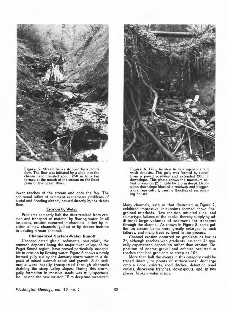
Figure 5. Stream banks stripped by a debris flow. The flow was initiated by a slide into the channel and traveled about 250 m to a fan formed at the mouth of the stream on the flood plain of the Green River.
lower reaches of the stream and onto the fan . The additional influx of sediment exacerbates problems of burial and flooding already caused directly by the debris flow .
Erosion by Water
Problems at nearly half the sites resulted from erosion and transport of material by flowing water. In all instances, erosion occurred in channels-either by incision of new channels (gullies) or by deeper incision in existing stream channels.
Channelized Surface-Water Runoff Unconsolidated glacial sediments, particularly the
outwash deposits lining the major river valleys of the Puget Sound region, have proved particularly susceptible to erosion by flowing water. Figure 6 shows a newly formed gully cut by the January storm water in a deposit of mixed outwash sands and gravels . Such sediments were readily transported through channels draining the steep valley slopes. During this storm, gully formation in massive sands was truly spectacular-at one site new incision 15 m deep was measured .
Washington Geology, vol. 19, no. 1 32
Figure 6. Gully Incision in heterogeneous outwash deposits . This gully was formed by runoff from a paved roadway and extended 200 m downslope. This photo shows the maximum extent of erosion (2 m wide by 1.5 m deep). Deposition downslope blocked a roadway and plugged a drainage culvert, causing flooding of surrounding houses.
Many channels, such as that illustrated in Figure 7 , exhibited impressive knickpoints formed above finegrained lnterbeds . New incision initiated slide- and slump-type failures of the banks, thereby supplying additional large volumes of sediment for transport through the channel. As shown in Figure 8, some gullies on stream banks were greatly enlarged by such failures, and many trees suffered in the process.
Channel erosion occurred on gradients as low as 3°, although reaches with gradients less than 4° typically experienced deposition rather than erosion. Deposition of coarse gravel and cobbles occurred in reaches that had gradients as steep as 10°.
More than half the events in this category could be traced directly to points of surface-water discharge onto a slope : culverts, road ditches, detention pond outlets , dispersion trenches, downspouts, and, in two places, broken water mains.

Figure 7. A knickpoint more than 3 m high at a ledge of silty material. The channel upslope leads to discharge from a road ditch. Runoff during the storm of January 9 contributed to ongoing erosion at this location.
Property damage resulting from erosion by surfacewater runoff was of two types: damage to structures (buildings, roadways, and utility lines) by bank failur'es following channel incision, and burial of property in zones of deposition . Deposition in channel reaches having low gradients, particularly in channels on alluvial fans, caused aggradation of the channel bed and subsequent shifting of the channel course. Parts of small stream channels were completely obliterated by deposition of material. An example is shown in Figure 9. Channel aggradation caused flooding and further deposition in areas previously considered (at least by those living there) safe from such problems.
Dam-Break Floods Another type of storm event warrants its own sub
division : during the storm of January 9 at least two sites experienced dam-break floods. Natural dams are formed by landslides into a channel and by log jams at channel restrictions. When a dam blocking a channel fails, the water impounded upstream flows downstream, essentially as a single mass. A wave of water
33
Figure 8. Surface runoff onto steep stream banks commonly produced vertical-walled, amphitheater-like scallops in the channel walls . These appear to be initiated by gullying, followed by bank failures which progress upslope. Failed material is quickly evacuated by the stream below.
pours down the channel, removing sediment and vegetation as it goes. The flood wave carries a growing mass of sediment and organic debris with it, and may take on the characteristics of a debris flow.
The dam break events noted in King County occurred where roads crossed small streams . Water was impounded at these crossings because the culverts through the road embankments were either plugged or too small to carry the stream flow . When the embankments failed, the flood wave formed by the impounded water traveled downstream, eroding the channel bed and stripping vegetation from the channel floor and banks. These floods picked up huge quantities of sediment and debris, including many large trees (Fig . 10). At one site, flood material was dumped onto the fan (and several houses) at the mouth of the stream, and at the other, the flood was impounded again by a railroad embankment downstream.
Washington Geology, vol. 19, no. 1

• human modifications to the environment favor certain (other) types of erosional processes.
We can begin to decipher this pattern by examining the causes of these events.
CAUSES OF THE EVENTS Many natural factors conspire to
produce spectacular erosional events during a large storm like that of January 9. The types of events cataloged in this study all have natural analogs In pristine environments unaffected by human development . However, only 16 percent of the events cataloged here appeared to be entirely natural. One goal of the inventory was to identify human alterations to the environment that may have triggered the event or increased the resulting damage. These alterations are divided into three categories:
Figure 9. Gravel deposition across a 20-m-wide swath at a site about 200 m downslope of a deeply incised gully has obliterated the former stream channel at this point.
(1) Drainage : typically, concentrated discharge of water draining from an impermeable surface (roadway or rooftop) onto (or in places, into, by
RESULTS Each site included in this inventory was categorized
as one of the above types of events . The number of each type is shown in Figure 11 .
Although I tried to be consistent in describing and cataloging what I saw at each site , it was difficult to unambiguously pigeonhole every occurrence. A single event typically involved a combination of the mechanisms listed above . For example, incision of a stream bed can destabilize the banks and cause slides into the channel. A slide into the channel can turn into a debris flow and travel the length of the stream. The debris flow removes the protective cover of vegetation from the channel, leaving the bed more vulnerable to subsequent incision. Natural processes operate in concert and the occurrence of one event can trigger a whole chain of events. For that reason, the results shown in Figure 11 reveal only a part of the story.
For the purposes of this study, each site was characterized by the process that transported the largest volume of sediment. In Figure 11, mass-wasting events and water-related (runoff plus dam-break) events are nearly equally divided: 57 percent of the sites were categorized as mass wasting, 43 percent as water related. This pattern is a consequence of two factors:
means of subsurface tiles) a slope.
(2) Grading: changes to a slope by either removal or addition of material. For example, many slumps occurred where material had been excavated from the toe of a slope, and many slides involved fill material that had been placed on a slope .
(3) Vegetation; removal or alteration of vegetation on a slope . Removal of vegetation causes the
• the geology and climate of this area favor certain types of erosional processes, and Figure 10. This tree was snapped off at its base by debris carried in
a dam-break flood.
Washington Geology, vol. 19, no. 1 34
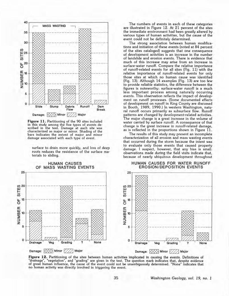
35
30
Cl) W25 I-C/)
en 20 w I-C/)
u. 15 0 a: w Ill 10 :E ::> z
5
5
MASS WASTING
Debris Flow
Damage: ~ Minor E222J Major
Figure 11. Partitioning of the 90 sites included in this study among the five types of events described in the text. Damage at each site was characterized as major or minor. Shading of the bars indicates the extent of major and minor damage associated with each type of event.
surface to drain more quickly, and loss of deep roots reduces the resistance of the surface materials to sliding .
HUMAN CAUSES OF MASS WASTING EVENTS
------------,r<~"7"7~------------
The numbers of events in each of these categories are illustrated in Figure 12. At 21 percent of the sites the immediate environment had been greatly altered by various types of human activities, but the cause of the event could not be definitely determined.
The strong association between human modifications and initiation of these events (noted at 84 percent of the sites cataloged) suggests that one consequence of development activities is an increase in the number of landslide and erosion events. There is evidence that much of this increase may arise from an increase in surface-water runoff. Compare the relative importance of runoff-related events for all sites (Fig. 11) with the relative importance of runoff-related events for only those sites at which no human cause was identified (Flg. 13). Although 14 examples (Fig. 13) are too few to provide reliable statistics, the difference between the figures is noteworthy: surface-water runoff is a much less important process among naturally occurring events. This observation reflects the impact of development on runoff processes. (Some documented effects of development on runoff in King County are discussed in Booth, 1989, 1990.) In western Washington, natural runoff occurs primarily as subsurface flow . Runoff patterns are changed by development-related activities. The major change is a great increase in the volume of water carried by surface runoff . A consequence of that change is the great increase in runoff-related damage, as is reflected in the proportions shown in Figure 11.
The results of this study may present an incomplete characterization of all erosion and mass wasting events that occurred during the storm because the intent was to evaluate only those events that caused property damage. I suspect, however, that any bias is small: observations made during the field visits indicate that, because of nearly ubiquitous development throughout
Cl) 20 w I-C/)
u. 15 0 a: w Ill 10 :E ::> z
5
HUMAN CAUSES FOR WATER RUNOFF EROSION/DEPOSITION EVENTS
-i,/'VV~~---- ----- ---------------
Veg Grading
Damage: ~ Minor E222J Major Damage: ~ r.iinor ~ r.iajor
Figure 12. Partitioning of the sites between human activities implicated In causing the events. Definitions of "drainage", "vegetation", and "grading" are given in the text. The question mark indicates that, despite evidence of great human influence, the cause of the event could not be unambiguously determined. "None" indicates that no human activity was directly involved in triggering the event.
35 Washington Geology, vol. 19, no. 1

7
6
Cl)
W5 I-C/)
LL 4 0
ffi 3 ID ~ => 2 z
DIVISION OF EVENTS WITH NO IDENTIFIED HUMAN CAUSE
Slide Dam Break
Damage: ~ Minor EZ22J Major
Figure 13. Partitioning of the 14 naturally occurring events (those labeled "none" in Figure 12) among the five types of events.
the western part of King County, most events caused some damage .
DAMAGE BY THE EVENTS Damage resulting from the storm can be divided
into two broad categories : that resulting from the removal of material, and that resulting from the deposition of material. Damage due to loss of material occurred to structures or utilities formerly supported by that material. Likewise, loss of ground at the head of a landslide or at the banks of a stream was typically viewed as a "bad" occurrence . Such damages were localized and had an obvious cause . Damage caused by deposition, on the other hand, typically occurred far from the site of erosion. The source of sediment and the cause of the problem were commonly not obvious to those affected. Indeed, many were oblivious to the hazard prior to the event. Likewise, the downstream consequences were typically not obvious to someone at the source . Some homeowners were surprised to discover that the small slide in their backyard produced the deposit which blocked the highway below for a week, or that the 2 feet of gravel inundating their lawn came from a failed detention pond a mile up the road. Naturally , material lost from one site ended up elsewhere, so many events caused both types of damage, though not necessarily at the same site .
As shown in figures 11 , 12, and 13, damage was defined as major or minor. The division was subjective and somewhat arbitrary. I attempted to separate those events corrected by routine maintenance anticipated for any large storm (such as cleaning of the road ditches) from those causing unanticipated damage . To achieve consistency, the following criteria were used.
Washington Geology, vol. 19, no. 1 36
Damage was considered to be major if the event caused one or more of the following :
• damage to a structure, • long-term consequences, such as destabilization
of a slope near a structure, and • effects on a large number of people.
Damage was defined as minor where the event : • required removal of debris only, with no damage
to a structure, • had no long-term consequences, or affected
only a few people. In general , larger volumes of material were involved
at sites of major damage than at places where minor damage was noted.
At 35 percent of the sites, damage was considered to be major. Most of the major damage caused by runoff events, debris flows , and dam-break floods resulted from deposition onto alluvial fans . In most instances, those living on the fans were unaware of the danger posed to them by the location of their homes. Yet, the very presence of a fan demonstrates that such depositional events are recurrent. Debris flows and fluvial processes constitute very real (though intermittent) hazards on fans . (See, for example, Logan, 1989; Kellerhals and Church, 1990.) The events of January 9, 1990, were instrumental in bringing about the inclusion of fans as potential landslide hazard areas in the King County Sensitive Areas Ordinance (King County Department of Parks , Planning and Resources, 1990).
DISCUSSION Many people affected by this storm claimed that ,
during the time they had lived in this area, they had never experienced such devastation from a single event. Yet, this storm was not particularly unusual. Recurrence intervals calculated for the 24 hour rainfall varied from 7 years in the north of the county to 33 years in the south. (This storm was, however, somewhat unusual in that it followed a fairly wet period; 96-hour recurrence intervals varied from 20 years in the north to 71 years in the south.) On the other hand, many people also admitted that the types of events described in this inventory had been occurring more commonly with each storm. The widespread damage of January 9 may be just a symptom of ongoing change.
Change is rapid in western King County. The area's population has increased 18. 7 percent over the past decade-an increase of 240,000 people . All counties in the Puget Sound region are experiencing similar or greater increases in population. All these people must live and work someplace. Demand for space is pushing development throughout the region, often into potentially hazardous areas that are affected by the processes discussed above .
With each new house and road, we unavoidably change the way water flows through the landscape. In effect, we have changed the way the land responds to rainfall. Increased damage from a single storm, such as that of January 9, is only one sign of this change . The damage is cumulative. The consequences of the storm on January 9 did not end when the rain stopped . The exposure of erodible surfaces by mass wasting and runoff provided a ready target for erosion in the next storm; the incision of gullies and streams left unstable slopes waiting to be activated; the great flux of sedi-

ment acted to change the character of our rivers and streams. The same is true of the storms preceding that of January 9, of those that followed (such as that in November 1990), and of those that will follow.
This study shows several ways in which our landscape responds to the climate . To anticipate this response, we must acknowledge both the susceptibility of this landscape to certain geomorphic processes and the effect of our activities upon those processes. Decisions for land use can then be made with an awareness of the potential consequences.
ACKNOWLEDGMENTS Both the Division of Building and Land Develop
ment (BALD) and the Division of Surface Water Management (SWM) provided funding for this project. John Bethel and Steve Bottheim, geologists with the Technical Services Section of BALD, receive much credit for the initiation and planning of this project, and for seeing that it came to a useful completion. Derek Booth, with the Basin Planning Section of SWM, also assisted with these tasks . Copies of the field reports and photo documentation of the sites are available at the Technical Services Section of BALD.
The staff at BALD and SWM provided information leading to many of the sites examined for this report. Other geologists and engineers working in the area were also very helpful in this regard. Jon Koloski and Don Tubbs at GeoEngineers, Inc . were particularly generous of their time and expertise. Lynne Miller assisted greatly with the field work.
REFERENCES CITED Booth, D. 8 ., 1989. Runoff and stream-channel changes fol
lowing urbanization in King County, Washington. In Gals-
ter, R. W., chairman, Engineering geology in Washington: Washington Division of Geology and Earth Resources Bulletin 78, v. II, p. 639-649.
Booth, D. B., 1990, Stream-channel incision following drainage-basin urbanization: Water Resources Bulletin v. 26, no. 3, p . 407-417.
Costa, J . E., 1984, Physical geomorphology of debris flows . In Costa, J. E.; Fleisher, P. J., Developments and applications of geomorphology: Springer-Verlag, p. 268-317.
Kellerhals, R.; Church, M., 1990, Hazard management on fans, with examples from British Columbia. In Rachocki, A. H.; Church, M., editors, Alluvial fans-A field approach: John Wiley and Sons, Ltd., p. 335-354.
King County Parks, Planning, and Resources Department, 1990, Sensitive areas map folio, King County, Washington: King County Parks, Planning and Resources Department, 1 v.
Logan, R. L., 1989, Geologic hazard Investigation near East Wenatchee, Washington: Washington Geologic Newsletter v. 17, no. 3, p. 3-6.
Thorsen, G. W., 1987, Soil bluffs + rain = slide hazards: Washington Geologic Newsletter, v. 15, no. 3, p . 3-11.
Thorsen, G. W. , 1989, Landslide provinces In Washington. In Galster, R. W., chairman, Engineering geology in Washington: Washington Division of Geology and Earth Resources Bulletin 78, v. I, p. 71-86 .
Tubbs, D. W., 1972, Landslides and associated damage during early 1972 in part of west-central King County, Washington, USA: U.S. Geological Survey Miscellaneous Investigations Series Map 1-852-B, 1 sheet, scale 1:48,000.
Tubbs, D. W., 197 4, Landslides In Seattle: Washington Division of Geology and Earth Resources Information Circular 52, 15 p .
Your House Comes out of a Mine Much of the raw material used in the construction of your home was furnished by the mining industry.
• The foundation probably is concrete (limestone, clay, shale, gypsum, and aggregate mining) .
• The exterior walls may be made of brick (clay mining) or stone (dimension stone mining).
• The insulation in the walls may be glass wool (silica, feldspar, and trona mining) or expanded vermiculite (vermiculite mining).
• The interior walls are commonly wallboard (gypsum mining).
• The roof is covered with asphalt shingles. The filler in the shingles is from a variety of colored silicate minerals from mining.
• Your fireplace probably is of brick or stone, lined with a steel box (iron ore mining).
• Your water pipes are of iron or copper (iron and copper ore mining) . Your sewer pipe is made of clay or iron pipe (clay and iron mining).
• Your electrical wiring is of copper or aluminum (copper and bauxite mining) .
• Your sanitary facilities are made of porcelain (clay mining) . Your plumbing fixtures and doorknobs are made of brass (copper and zinc mining) or stainless steel (iron, nickel, and chrome mining).
• Your gutters are of galvanized iron (iron and zinc ore mining).
• The paint on your walls is manufactured with mineral fillers and pigment.
• The glass in your windows is a product of trona, silica sand, and feldspar mining. And finally, your mortgage is written on paper made with wood and cloth fibers filled with clay or coated with
carbonate (quarrying). Modi/led from the January 1976 and February 1976 Issues of GEM Facts, by F. T. Davis, Society of Mining
Engineers regional vice president.
37 Washington Geology, vol. 19, no. 1

Lakes Divided: The Origin of Lake Crescent and Lake Sutherland, Clallam County, Washington
by Robert L. Logan
Division of Geology and Earth Resources
Set in a glacier-carved valley on the north side of the Olympic Peninsula (Fig. 1), Lakes Crescent and Sutherland share a common heritage . For a time during the Holocene they were one large lake, "Ancient Lake Crescent" (Tabor, 1987, p. 98-99), whose basin had been eroded in the northern Olympic Mountains in late Pleistocene time by a lobe of the Cordilleran ice sheet. After the ice receded about 13,000 years ago, this lake drained eastward through the valley now occupied by Indian Creek and into the north-flowing Elwha River to the Strait of Juan de Fuca (Figs . 1 and 2).
Sometime after the ice retreated, a series of large landslides separated ancestral Lake Crescent into today's Lakes Crescent and Sutherland (cover photo),
Vancouver
Island
48° Lake~
Crescent
•
I Forks ~ :,;,
tu i ("\ ... -. --. Study -.
("\
Area a ("\
Cb tu
47° '::)
Robert L. Schuster U.S. Geological Survey Denver, Colorado
altering the regional drainage. Such natural blockages of drainage by landslides are common in mountain environments throughout the world (Costa and Schuster, 1988). As noted by Reagan ( 1909), Quileute Indian legend tells of a large piece of rock falling from Mount Storm King (Fig. 2) and blocking the stream that drained the area to the east. This slide was mapped by Brown and others ( 1960) and its extent expanded by Fiksdal and Brunengo ( 1980) by means of interpretation of aerial photography. Weaver (1937) recognized the dam of Lake Crescent as a landslide, but he stated only that "the conglomerates of the Lyre formation transgress unconformably over the Boundary shales and underlying Crescent formation immediately east of
British Columbia -·--·-·
Lake Crescent." Loney (1951) also recognized the dam as a landslide. Tabor (1987) noted that most of the debris on the landslide surface came from the north, not from Mount Storm King . Our recent investigations reveal that the partition between the lakes is the result of large multiple rock slides and rock avalances. The first of these came from the south and was followed by landslides from the north .
LANDSLIDE BLOCKAGE OF ANCIENT
LAKE CRESCENT
0 20 Olympia
At some time after the glacier ice receded from the area in latest Pleistocene time, a large mass of rock slid from Mount Storm King into ancient Lake Crescent from its southeast shore (Fig. 2). This slide was large enough to divide the ancestral lake into two smaller lakes. Because the western lake (Crescent) then had no outlet, its surface level rose until water spilled over the landslide dam into Lake Sutherland to the east. Drainage across the landslide ended when a series of landslides from the north (Fig. 2) overrode the older slide. The younger slides Impounded Lake Crescent again and raised its level until water flowed over the
MILES
Figure 1. Map of northwestern Washington showing the location of the study area.
Washington Geology, vol. 19, no. 1 38
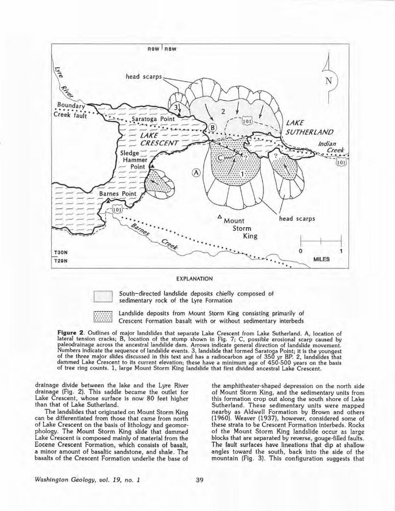
• ~~u.n!'ary-:---1:1!-... ~-.... Creek f;~lt • •
T30N
T29N
R9W RBW
Sledge~ ~~--, ............ , . Hamm~ " ~ Point
... .. <9q' ••••• ,...,,.. ..
-,<.C>.s- •• ... . ..
A
. . .
Mount Storm
King
... .. ...
N
SUTHERLAND
scarps
0 1 MILES . .
EXPLANATION
~ L2_:_j
South-directed landslide deposits chiefly composed of sedimentary rock of the Lyre Formation
Landslide deposits from Mount Storm King consisting primarily of Crescent Formation basalt with or without sedimentary interbeds
Figure 2. Outlines of major landslides that separate Lake Crescent from Lake Sutherland. A, location of lateral tension cracks; B, location of the stump shown in Fig. 7; C, possible erosional scarp caused by paleodrainage across the ancestral landslide dam. Arrows indicate general direction of landslide movement. Numbers indicate the sequence of landslide events. 3, landslide that formed Saratoga Point; it is the youngest of the three major slides discussed in this text and has a radiocarbon age of 350 yr BP. 2, landslides that dammed Lake Crescent to its current elevation; these have a minimum age of 450-500 years on the basis of tree ring counts. 1, large Mount Storm King landslide that first divided ancestral Lake Crescent.
drainage divide between the lake and the Lyre River drainage (Fig. 2). This saddle became the outlet for Lake Crescent, whose surface is now 80 feet higher than that of Lake Sutherland.
The landslides that originated on Mount Storm King can be differentiated from those that came from north of Lake Crescent on the basis of lithology and geomorphology. The Mount Storm King slide that dammed Lake Crescent is composed mainly of material from the Eocene Crescent Formation, which consists of basalt, a minor amount of basaltic sandstone, and shale. The basalts of the Crescent Formation underlie the base of
Washington Geology, uo/. 19, no. 1 39
the amphitheater-shaped depression on the north side of Mount Storm King, and the sedimentary units from this formation crop out along the south shore of Lake Sutherland. These sedimentary units were mapped nearby as Aldwell Formation by Brown and others (1960). Weaver (1937), however, considered some of these strata to be Crescent Formation interbeds . Rocks of the Mount Storm King landslide occur as large blocks that are separated by reverse, gouge-filled faults. The fault surfaces have lineations that dip at shallow angles toward the south, back into the side of the mountain (Fig . 3). This configuration suggests that

Figure 3 . Thrust fault exposed along the south shore of Lake Sutherland. The direction of lineations on the fault surface is indicated by the orientation of the pen.
these blocks were thrust northward during rotational sliding .
Swales aligned parallel to the western edge of the slide scarp (site A, Fig . 2) are covered with old growth timber (Fig. 4). Tree-ring counts indicate these trees are 500-600 years old. We have interpreted the swales as partly filled ancient tension cracks .
Almost the entire surface of the Mount Storm King landslide that dammed Lake Crescent is covered by boulder-sized rubble (Fig . 5) of basalt of the Crescent Formation; no outcrops were observed . The antiquity of the slide is suggested by its relatively smooth topography. The younger slides from the north have much greater surface relief and are composed of conglomerates and coarse sandstones of the Lyre Formation . Large boulders, some several meters in diameter, are common on the surfaces of these slides. The landslide headwall scarps rise prominently above the north side of the landslide dam (Fig . 2) .
The younger slides are also covered by old-growth timber. The stump shown in Figure 6 (at site B, Fig . 2) has 500-550 rings . It is rooted in the landslide that forms the eastern shore of Lake Crescent. Numbers on Figure 2 indicate the estimated relative ages of the landslides that make up the dam mass. These ages were assigned on the basis of morphology and radiocarbon dates.
Subsidiary landslides have occurred along the shores of Lakes Crescent and Sutherland since the lake level reached its present height. One of these slides forms the headland known as Saratoga Point (Fig. 2) in northeastern Lake Crescent. In 1983, National Park Service divers removed the top of a snag that protruded above the lake surface about 250 feet offshore from Saratoga Point . The snag is rooted in the lake bottom at a depth of about 90 feet; the divers cut it off 20 feet below the lake surface (Fig. 7) . A radiocarbon age of 350 yr BP was obtained by Snavely (1987) from the outermost rings of a slab cut from the snag . In 1990, we obtained a radiocarbon age of 280 ± 60 yr BP from another slab taken from the snag . The snag is tilted toward the shoreline as if its base had been rotated during the emplacement of the slide mass. The Saratoga Point slide apparently occurred as an event that was separate from
Michael Butler, a ranger for Olympic National Park who helped us obtain wood for radiocarbon dating, has reported seeing a submerged tree during a dive in Lake Crescent between Barnes Point and Sledge Hammer Point. If this tree is rooted in a submerged but undisturbed slope, then it suggests that the last landslide to dam the lake probably did not occur soon after the continental ice withdrew. A radiocarbon age from the tree should reveal the approximate date of the event that dammed the lake to its current elevation .
Figure 4 . Swale interpreted to be a remnant of a lateral tension crack. Note old-growth trees.
Washington Geology, uol. 19, no. 1 40

EFFECT OF DAMMING ON DEVELOPMENT OF
CUTTHROAT TROUT An interesting consequence of the
partitioning of ancient Lake Crescent is the influence it may have had on a local variety of cutthroat trout. Pierce {1984) described physical differences, particularly color and the number of basibranchial teeth, between the cutthroat trout in Lakes Crescent and Sutherland that may be the result of the two populations having been isolated from one another by the separation of the lakes. He attributed the differences to inbreeding in the separated populations.
Figure 5. Boulders on the surface of the Mount Storm King landslide that are small enough to be nearly obscured by slash from recent logging activity. No bedrock outcrops were found on this surface.
It is possible that the Storm King landslide did not isolate the biological communities of the lakes for long; there is geologic evidence that drainage from Lake Crescent was re-established across the landslide soon after the lake level rose above the dam. This evidence consists of an abrupt scarp near the toe of the Mount Storm King landslide on the south edge of the land-
the earlier larger landslide that raised Lake Crescent to its current level.
CAUSE OF LANDSLIDES Nearly all landslides in western Washington have
been caused by either (1) reduction of shear strength of geologic materials due to saturation resulting from rainfall or snowmelt, or (2) dynamic forces released by earthquakes. In our opinion, a high percentage of
slide dam {site C, Fig. 2; Fig . 8) which probably is the result of erosion of the
surface of the older landslide mass. However, the younger landslide completely blocked
drainage between the two lakes. Thus, if the age of the younger landslide can be established, a minimum date for isolation of the trout populations can be determined and a better understanding of the rate of evolution of these fish may be gained .
major rock slides and rock avalanches in western Washington has resulted from earthquake activity. Thus, we feel that there is a strong probability that the Lake Crescent/Lake Sutherland landslides were earthquake-triggered. Tabor {1987) described aligned faceted spurs and an adjacent zone of crushed rock as geomorphological evidence for a possible active fault in the Barnes Creek drainage (Fig. 2) on the south side of Mount Storm King. The Boundary Creek fault (Brown and others, 1960) passes beneath Lake Sutherland and the eastern end of Lake Crescent. Recent seismic activity in the area may be related to this fault as well (P. D. Snavely, Jr., USGS, oral commun., 1991). Subduction-related earthquakes may be capable of causing large landslides, such as those found at Lake Crescent. Atwater (1987) has described geologic evidence of great earthquakes f Richter magnitude 8.0 or greater) along the Washington coast that have occurred during the Holocene.
Figure 6. A 500- to 550-year-old stump on surface of landslide that dammed Crescent Lake to its present elevation . The slump location is indicated by the letter B on Figure 2.
41 Washington Geology, vol. 19, no. 1

figure 7. A submerged snag in Lake Crescent photographed through a ballyscope. This snag was sawed off at a depth of 20 feet.
CONCLUSIONS Was ancient Lake Crescent divided by a series of
earthquake induced landslides? We think so; however, it is not yet clear when the present configuration of the lakes was established, if seismic events were responsible for this configuration, and how many seismic events there were . Continued research on the geology of the landslides that dammed ancient Lake Crescent should yield a better understanding of the seismic history of the Pacific Northwest, as well as occasionally provide a good fish story.
ACKNOWLEDGMENTS For their assistance during our
field effort we thank: Gordon Green for providing the slab of wood from the Saratoga Point snag and other historical information; the John Halberg family for their help with local access and historical information; Michael Butler and Robert Steffy of the National Park Service for locating the Saratoga Point snag and providing us with boat transport.
REFERENCES CITED Atwater, B. F., 1987, Evidence for great
Holocene earthquakes along the outer coast of Washington State: Science, v. 236, no. 4804, p. 942-944.
Brown, R. D.; Gower, H. D.; Snavely, P. D., Jr., 1960, Geology of the Port Angeles-Lake Crescent area, Clallam County, Washington: U.S. Geological Survey Oil and Gas Investigation Map OM-203, 1 sheet, scale 1:62,500.
Costa, J. E.; Schuster, R. L., 1988, The formation and failure of natural dams: Geological Society of America Bulletin, v. 100, p. 1054-1068.
Fiksdal, A. J .; Brunengo, M. J ., 1980, Forest slope stability project, Phase I: Washington Department of Ecology Technical Report 80-2a, 18 p., 7 pl.
Loney, R. A., 1951, Geology of the Crescent Bay area, Olympic Peninsula, Washington : University of Washington Master of Science thesis, 116 p., 3 plates, scale 1:31,680.
Pierce, B. E., 1984, The trouts of Lake Crescent, Washington: Colorado State University Master of Science thesis, 252 p.
Reagan, A. B., 1909, Some notes on the Olympic Peninsula, Washington: Kansas Academy of Science Transactions 22, p. 132-238.
Snavely, P. D., Jr., 1987, Tertiary geologic framework, neotectonics, and petroleum potential of the OregonWashington continental margin. In Scholl, D. W.; Grantz, A.; Vedder, J . G., editors., Geology and resource potential of the continental margin of western North America and adjacent Ocean Basins--Beaufort Sea to Baja California: Circum-Pacific Council for Energy and Mineral Resources Earth Science Series, v. 6, p. 305-335.
Tabor, R. W., 1987, Geology of Olympic National Park: Pacific Northwest National Parks and Forests Association, [Seattle) , 144 p.
Weaver, C. E., 1937, Tertiary stratigraphy of western Washington and northwestern Oregon: University of Washington Publications in Geology, v. 4, 266 p.
Figure 8 . Erosional scarp, arrow, on the surface of the Mount Storm King landslide. Note the U-shape of the glacier-carved valley in the upper right-hand corner of the figure. View is to the southwest.
Washington Geology, ool. 19, no. 1 42

Geologic Work Grinds to a Halt: Politics and Finances -1891-1893
By J . Eric Schuster
Editor's Note: This is the fourth in a series of articles recounting the history of the early years of Washington's geological survey.
While Eugene Ricksecker, Paul F. Riecker, and H. E. Parrish (assistant geologists) were working in their respective field areas in 1891 (see vol. 18, no . 4 of this newsletter), a crisis was brewing in Olympia . The first manifestations were fiscal, but the problem soon entered the political-legal arena.
By law, the officers of the Mining Bureau were to examine, audit, and allow all bills arising from the performance of the geologists' duties and present such bills to the State Auditor. Apparently, in the first weeks of the mineralogical and geological survey activities of 1891, the State Auditor had caused these bills to be paid out of the smaller appropriations of the Mining Bureau, not out of the $50,000 appropriation for making a mineralogical and geological survey of the state . When these appropriations were nearly exhausted, State Auditor Thomas M. Reed refused to issue any further warrants. Reed claimed that ,
" ... upon examination of the law creating a Mining Bureau, and defining its duties, approved February 25, 1890, I fail to find any provision whereby it is authorized to superintend a geological survey of the state, or is given the power to audit the claims incurred by parties engaged in the performance of such service ... [and thatJ ... the provision in the general appropriation act of March 7, 1891 , making an appropriation for a geological and mineralogical survey of the state, does not designate any officer or commission whose duty it shall be to expend the same; and I am therefore of the opinion that the appropriation herein referred to cannot be drawn until further legislation has been had upon the subject" (Kreider, 1891, p. 492).
The mining Bureau maintained that it could draw on the larger appropriation and chose to submit the matter to the Supreme Court . In a decision dated June 26, 1891, the Supreme Court upheld the interpretation of the State Auditor. With that decision, the attempt to pursue a geological and mineralogical survey of the state was effectively at an end.
While the money matters were being contested by the Mining Bureau and the State Auditor, the field parties were thrown into difficult circumstances because their bills had been left unpaid . Ricksecker wrote to A. A. Lindsley from Conconully on July 7:
"Dear Sir--Yesterday I wired you: 'Instructions received; can't move without an attachment being served on personal and state property.' To-day I wire you: 'Attachment served on me to-day; hearing set for 13th.'
"The sheriff interviewed me this morning at 6 o'clock and seized five horses to cover an indebted .. ness of $66. I intended riding out with the freight team. None of my men have money, nor have I, for that matter. No state property has been seized yet, although threatened. Hardenbergh brought suit in
43
company with Dickson. Am at a loss what policy to pursue here. The horses will be taken by the original owners if I do not appear at the hearing, and I do not see how I can stop them by appearing. This is the most outrageous thing I ever got into, and I sincerely trust that you will be successful in the efforts I hear you are making to cancel our indebtedness without delay" (Laughton and Lindsley, 1892, p . 12-13).
Parrish 's plight apparently was worse; he wrote Lindsley from Carbonado on July 7 (Laughton and Lindsley, 1892, p . 40-41) :
"Dear Sir--Enclosed you will find vouchers up to date . I shall have detailed report and maps ready to forward in a few days. It is absolutely necessary that I should receive money for my men at once, also for the cook. The men cannot go into town, as they have not a cent, and would be arrested for indecent exposure if they did . They are indeed in bad shape and must have assistance.
"Kindly let me hear from you at once, and oblige yours respectfully,
"H. E. Parrish "Assistant Geologist"
C . E. Laughton (Mining Bureau President) and Lindsley (1892, p. 42-43) ordered the field parties to cease work, recalled the assistant geologists to Olympia, and advanced personal funds " . .. to meet the immediate requirements of those employes [sic] most in need of help ... " The unpaid debts were finally settled by a deficiency appropriation of $8,000 made by the 1893 legislature (Price, 1893, p . 277).
The reaction of the Mining Bureau to the denial of access to the $50,000 appropriation and the legal decision that terminated geologic investigations is recorded in their annual report (Laughton and Lindsley, 1892, p . 42), addressed to Governor Ferry, as follows:
"We do not desire in this report to enter into an argument as to the merits of the question involved, and so summarily dismissed by the supreme court; but, for the best interests of those engaged in mining, whose number is being augmented daily, and for the development of an industry which we believe will be the most potent factor in the progress and prosperity of the state, we regret that the so evident intent of the legislature should have been ignored and that the statute was construed according to the strict letter of the law and not the spirit of the law."
G. A. Bethune (1892, p. 9-10), in his second annual report, which was addressed to Governor Ferry and the members of the State Mining Bureau, said of ihe maiier:
"Acting upon the fact that this appropriation had passed both houses, and had been, therefore, recommended to the acting governor for his approval and
Washington Geology, uo/. 19, no. 1
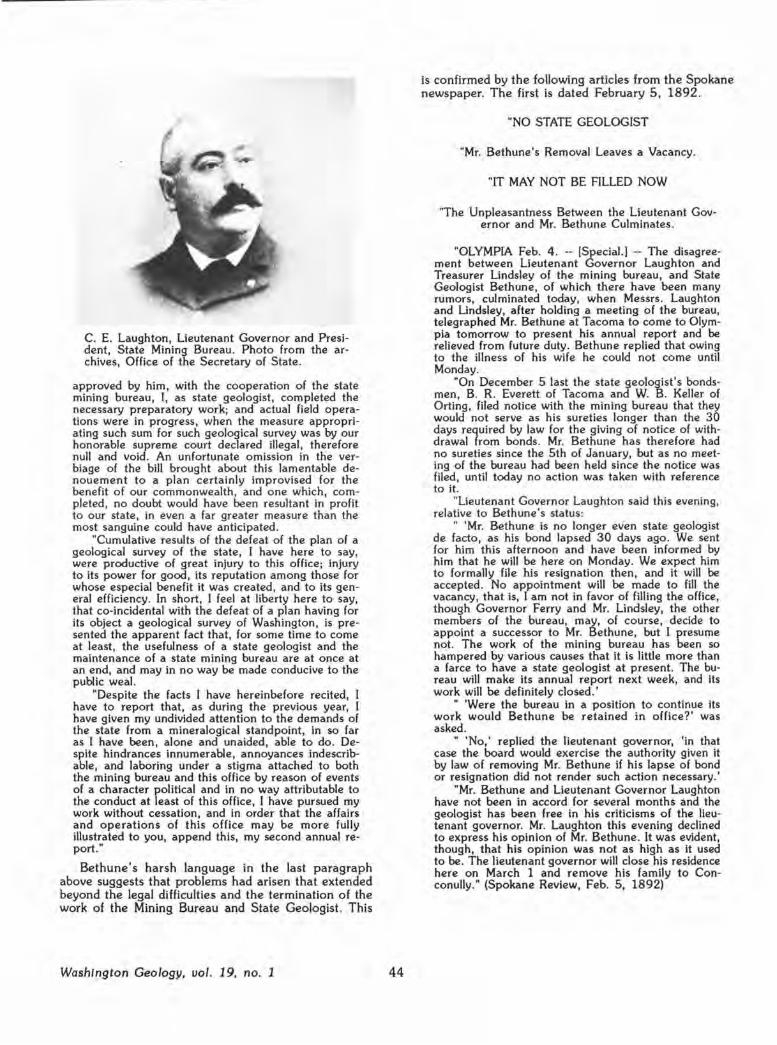
C. E. Laughton, Lieutenant Governor and President, State Mining Bureau. Photo from the archives, Office of the Secretary of State.
approved by him, with the cooperation of the state mining bureau, I, as state geologist, completed the necessary preparatory work; and actual field operations were in progress, when the measure appropriating such sum for such geological survey was by our honorable supreme court declared illegal, therefore null and void . An unfortunate omission in the verbiage of the bill brought about this lamentable denouement to a plan certainly improvised for the benefit of our commonwealth, and one which , completed, no doubt would have been resultant in profit to our state, in even a far greater measure than the most sanguine could have anticipated .
"Cumulative results of the defeat of the plan of a geological survey of the state, I have here to say, were productive of great injury to this office; injury to its power for good, its reputation among those for whose especial benefit it was created, and to its general efficiency. In short, I feel at liberty here to say, that co-incidental with the defeat of a plan having for its object a geological survey of Washington , is presented the apparent fact that, for some time to come at least, the usefulness of a state geologist and the maintenance of a state mining bureau are at once at an end, and may in no way be made conducive to the public weal.
"Despite the facts I have hereinbefore recited, I have to report that, as during the previous year, I have given my undivided attention to the demands of the state from a mineralogical standpoint, in so far as I have been, alone and unaided, able to do . Despite hindrances innumerable, annoyances indescribable, and laboring under a stigma attached to both the mining bureau and this office by reason of events of a character political and in no way attributable to the conduct at least of this office, I have pursued my work without cessation, and in order that the affairs and operations of this office may be more fully illustrated to you, append this, my second annual report. "
Bethune's harsh language in the last paragraph above suggests that problems had arisen that extended beyond the legal difficulties and the termination of the work of the Mining Bureau and State Geologist. This
Washington Geology, vol. 19, no. 1 44
is confirmed by the following articles from the Spokane newspaper. The first is dated February 5, 1892.
"NO STATE GEOLOGIST
"Mr. Bethune's Removal Leaves a Vacancy.
"IT MAY NOT BE FILLED NOW
"The Unpleasantness Between the Lieutenant Governor and Mr. Bethune Culminates.
"OLYMPIA Feb. 4 . -- [Special.) -- The disagreement between Lieutenant Governor Laughton and Treasurer Lindsley of the mining bureau, and State Geologist Bethune, of which there have been many rumors, culminated today, when Messrs . Laughton and Lindsley, after holding a meeting of the bureau, telegraphed Mr. Bethune at Tacoma to come to Olympia tomorrow to present his annual report and be relieved from future duty. Bethune replied that owing to the illness of his wife he could not come until Monday.
"On December 5 last the state geologist's bondsmen, B. R. Everett of Tacoma and W. B. Keller of Orting, filed notice with the mining bureau that they would not serve as his sureties longer than the 30 days required by law for the giving of notice of withdrawal from bonds. Mr. Bethune has therefore had no sureties since the 5th of January, but as no meeting of the bureau had been held since the notice was filed, until today no action was taken with reference to it.
"Lieutenant Governor Laughton said this evening, relative to Bethune 's status:
" 'Mr. Bethune is no longer ev·en state geologist de facto, as his bond lapsed 30 days ago . We sent for him this afternoon and have been informed by him that he will be here on Monday. We expect him to formally file his resignation then , and it will be accepted . No appointment will be made to fill the vacancy , that is, I am not in favor of filling the office, though Governor Ferry and Mr. Lindsley, the other members of the bureau, may, of course , decide to appoint a successor to Mr. Bethune, but I presume not. The work of the mining bureau has been so hampered by various causes that it is little more than a farce to have a state geologist at present. The bureau will make its annual report next week, and its work will be definitely closed. '
" 'Were the bureau in a position to continue its work would Bethune be retained in office?' was asked.
" 'No,' replied the lieutenant governor, 'in that case the board would exercise the authority given it by law of removing Mr. Bethune if his lapse of bond or resignation did not render such action necessary.'
"Mr. Bethune and Lieutenant Governor Laughton have not been in accord for several months and the geologist has been free in his criticisms of the lieutenant governor. Mr. Laughton this evening declined to express his opinion of Mr. Bethune . It was evident, though, that his opinion was not as high as it used to be. The lieutenant governor will close his residence here on March 1 and remove his family to Conconully." (Spokane Review, Feb. 5 , 1892)
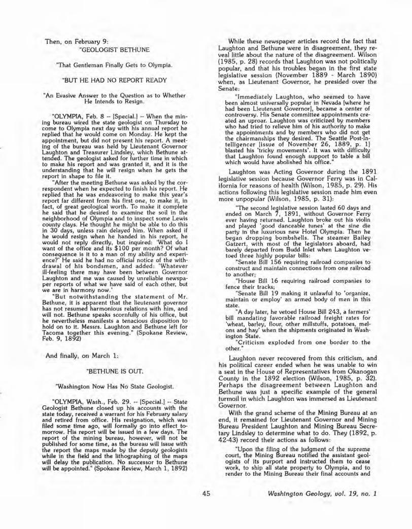
Then, on February 9: "GEOLOGIST BETHUNE
"That Gentleman Finally Gets to Olympia.
"BUT HE HAD NO REPORT READY
"An Evasive Answer to the Question as to Whether He Intends to Resign.
"OLYMPIA, Feb. 8 -- [Special.) -- When the mining bureau wired the state geologist on Thursday to come to Olympia next day with his annual report he replied that he would come on Monday. He kept the appointment, but did not present his report . A meeting of the bureau was held by Lieutenant Governor Laughton and Treasurer Lindsley, which Bethune attended. The geologist asked for further time in which to make his report and was granted it, and it is the understanding that he will resign when he gets the report in shape to file it.
"After the meeting Bethune was asked by the correspondent when he expected to finish his report. He replied that he was endeavoring to make this year's report far different from his first one, to make it, in fact, of great geological worth. To make it complete he said that he desired to examine the soil in the neighborhood of Olympia and to inspect some Lewis county clays. He thought he might be able to do this in 30 days, unless rain delayed him. When asked if he would resign when he handed in his report, he would not reply directly, but inquired: 'What do I want of the office and its $100 per month? Of what consequence is it to a man of my ability and experience?' He said he had no official notice of the withdrawal of his bondsmen, and added: 'Whatever ill-feeling there may have been between Governor Laughton and me was caused by unreliable newspaper reports of what we have said of each other, but we are in harmony now.'
"But notwithstanding the statement of Mr. Bethune, it is apparent that the lieutenant governor has not resumed harmonious relations with him, and will not. Bethune speaks scornfully of his office , but he nevertheless manifests a tenacious disposition to hold on to it. Messrs. Laughton and Bethune left for Tacoma together this evening." (Spokane Review, Feb. 9, 1892)
And finally, on March 1:
"BETHUNE IS OUT.
"Washington Now Has No State Geologist.
"OLYMPIA, Wash., Feb. 29. -- [Special.) -- State Geologist Bethune closed up his accounts with the state today, received a warrant for his February salary and retired from office. His resignation, which was filed some time ago, will formally go into effect tomorrow. His report will be issued in a few days. The report of the mining bureau, however, will not be published for some time, as the bureau will issue with the report the maps made by the deputy geologists while in the field and the lithographing of the maps will delay the publication. No successor to Bethune will be appointed." (Spokane Review, March 1, 1892)
45
While these newspaper articles record the fact that Laughton and Bethune were in disagreement, they reveal little about the nature of the disagreement. Wilson (1985, p . 28) records that Laughton was not politically popular, and that his troubles began in the first state legislative session (November 1889 - March 1890) when, as Lieutenant Governor, he presided over the Senate:
"Immediately Laughton, who seemed to have been almost universally popular in Nevada [where he had been Lieutenant Governor), became a center of controversy. His Senate committee appointments created an uproar. Laughton was criticized by members who had tried to relieve him of his authority to make the appointments and by members who did not get the chairmanships they desired . The Seattle Post-Intelligencer [issue of November 26, 1889, p . 1) blasted his 'tricky movements'. It was with difficulty that Laughton found enough support to table a bill which would have abolished his office."
Laughton was Acting Governor during the 1891 legislative session because Governor Ferry was in California for reasons of health (Wilson , 1985, p. 29). His actions following this legislative session made him even more unpopular (Wilson, 1985, p . 31):
"The second legislative session lasted 60 days and ended on March 7, 1891, without Governor Ferry ever having returned. Laughton broke out his violin and played 'good danceable tunes' at the sine die party in the luxurious new Hotel Olympia. Then he began dropping bombshells. The steamer Bailey Gatzert, with most of the legislators aboard, had barely departed from Budd Inlet when Laughton vetoed three highly popular bills:
"Senate Bill 156 requiring railroad companies to construct and maintain connections from one railroad to another;
"House Bill 16 requiring railroad companies to fence their tracks;
"Senate Bill 19 making it unlawful to 'organize, maintain or employ' an armed body of men in this state.
"A day later, he vetoed House Bill 243, a farmers' bill mandating favorable railroad freight rates for 'wheat, barley, flour, other millstuffs, potatoes, melons and hay' when the shipments originated in Washington State.
"Criticism exploded from one border to the other."
Laughton never recovered from this criticism, and his political career ended when he was unable to win a seat in the House of Representatives from Okanogan County in the 1892 election (Wilson, 1985, p. 32). Perhaps the disagreement between Laughton and Bethune was Just a specific example of the general turmoil in which Laughton was immersed as Lieutenant Governor.
With the grand scheme of the Mining Bureau at an end, it remained for Lieutenant Governor and Mining Bureau President Laughton and Mining Bureau Secretary Lindsley to determine what to do. They (1892, p . 42-43) record their actions as follows:
"Upon the filing of the judgment of the supreme court, the Mining Bureau notified the assistant geologists of its purport and Instructed them to cease work, to ship all state property to Olympia, and to render to the Mining Bureau their final accounts and
Washington Geology, vol. 19, no. 1

reports. These instructions were complied with, and Messrs. Ricksecker, Riecker and Parrish reported to the Mining Bureau in Olympia. At this juncture the Mining Bureau found itself in a most embarrassing position . The men in the field had been without money for nearly two months; creditors who had furnished supplies and subsistence were importunate, and in some cases the men employed were entirely destitute, without money, clothing or food; they were far removed from lines of railway travel and populous centers; they could neither obtain employment nor reach places where employment might be found. The integrity of the state and of the individuals composing the Mining Bureau was assailed and criticized. The president and secretary of the Mining Bureau person-
ally advanced a sufficient sum of money to meet the immediate requirements of those employes (sic] most in need of help, and the question of liquidation of the indebtedness incurred demanded immediate consideration .
" ... We have used nearly all of the balance of the appropriation for Incidental expenses in part payment of claims incurred by reason of the survey. Certificates have been Issued by the Mining Bureau to individual creditors for the obligations incurred by our order, amounting in the aggregate to $6,142.22 . For this indebtedness there is no relief except by legislation authorizing its payment. We therefore respectfully request you (Governor Ferry) to call the attention of the legislature, when next in session , to this mat·
The perspective drawing above is taken from one of the plates in the first annual report of the Mining Bureau of the State of Washington, by C. E. Laughton and A. A. Lindsley. [See references, this article.] Dominion Hill, northeast of Colville
Washington Geology, uol. 19, no. 1 46

ter, to the end that immediate and favorable action may be taken and the credit of the state and its officers, while honestly engaged in duties prescribed by law, be maintained. "
The 1893 legislature did provide financial relief in the form of a deficiency appropriation, as noted above . It also, in the same bill, provided a small deficiency appropriation for the State Geologist:
"For deficiency in appropriation for rent of office for state geologist for fiscal term ending March 31, 1893, to be paid to B. and C. S. Barlow, two hundred and twenty-five dollars ($225.00)" (Price, 1893, p . 278).
The same legislature appropriated funds for the Mining Bureau and State Geologist for the fiscal term beginning April 1, 1893, and ending March 31, 1895, as follows : $4 ,800 for salary of State Geologist at $2,400 per year (double the previous salary), $500 for chemicals at $250 per year, $2,000 for contingent and traveling expenses of State Geologist and Mining Bureau at $1,000 per year, and $600 for rent of office at $300 per year, for a total of $7,900 (Price , 1893, p . 454). However, Governor McGraw vetoed this appropriation, along with a number of others, noting that to do otherwise would involve incurring a deficit so
in Stevens County, is now known as Old Dominon Mountain ; the view is to the east from Colville Mountain. The buildings in the center foreground are Fort Colville, and the area around the fort is Garrison Flat. The artist was Will iam Bull .
47 Washington Geology, vol. 19, no. 1

large as to be unconstitutional, while admitting that all of the items vetoed
"may be worthy and proper subjects for legislative appropriation whenever the income of the state and the provisions of the constitution may warrant their approval" (Price, 1893, p . 460-461).
Their frustration at the demise of the enterprise, as well as their hopes for the future, are probably best summed up by Laughton and Lindsley' s conclusion to their first annual report (1892, p . 45-46) :
"We are living in an age of progressive thought and of practical scientific research . Blind groping in darkness without the guiding light of intelligent information will accomplish but little in the development of the manifold resources with which our state is abundantly endowed . The arguments in favor of the continuation of the work of the Mining Bureau are legion. Investors and settlers--particularly foreign capitalists, prior to investment, desire a knowledge of the constituent elements of the soil and its geological formation, for upon this knowledge they base opinions as to the existence of the precious and other metals as well as the cultivation of fruits, vegetables, cereals and all other agricultural commodities. The direct object sought to be attained by the Mining Bureau is to place the mining interests upon a scientific basis which will enable prospectors to form intelligent opinions as to the existence of and where to search for the precious metals ; to so guide the intending settler, by careful analysis of soils, that our immense unoccupied areas of arable land may be dotted with happy homes; and it emphatically and above all should be the advertising bureau of the magnificently rich natural resources of Washington . These purposes fully attained would invite an unprecedented Immigration of a most desirable class of citizens, and our almost exhaustless deposits of coal , iron, lead, silver and gold would attract the investment of such amounts of capital that the return to the state by reason of the increase of taxable values would equal the amounts appropriated, and to be appropriated by the legislature.
"The investigation of the Mining Bureau, hampered as It has been by adverse and senseless criticism, and by a lack of co-operation upon the part of some who should have given its workings their attentive interest, has, notwithstanding, developed the existence within our state of an empire of mineral wealth , with which the world was little acquainted until by the wisdom of our legislature the Mining Bureau was established.
"The discovery of anthracite coal, asbestos, cement--equal in value to the Portland--fire and potters' clay, marble, both white and variegated, as well as
Washington Geology, vol. 19, no. 1 48
immense deposits of clay containing a large percentage of aluminium, are only a part of the results already attained.
"The proper presentation to the public of these riches, which can only be accomplished by scientific examination and investigation, remains an unfinished work of the Mining Bureau. But we have such a profound respect for the intelligence of the people's representatives that we confidently submit the matter to the members of the next legislature, feeling assured that they will so wisely legislate upon this important question that Washington will take rank, as is her place, among the first of the rich sisterhood of states.
"Chas. E. Laughton, President, "A. A. Lindsley, Secretary, "Mining Bureau, State of Washington ."
Washington's first attempt to deal systematically with its geology and mineral resources had ended, not a victim of legislative or executive disapproval or of a lack of appreciation of its potential value, but because it was involved in a legal test that constituted part of the "shakedown" or definition of roles in a newly formed state government.
References Cited
Bethune, G. A., 1891, Mines and minerals of Washington, Annual report of George A. Bethune, Rrst State Geologist: 0 . C. White, State Printer, Olympia, Wash., 123 p.
Bethune, G. A. , 1892, Mines and minerals of Washington, Second annual report of George A. Bethune, State Geologist: 0 . C. White, State Printer, Olympia, Wash., 187 p .
Kreider, E. G., reporter, 1891, Reports of cases determined in the Supreme Court of the State of Washington, containing decisions rendered during the January and May sessions, 1891, and the rules of Supreme Court adopted November 2, 1891: 0 . C . White, State Printer, Olympia, Wash., v. 2, 747 p.
Laughton, C. E.; Lindsley, A. A., 1892, Rrst annual report of the Mining Bureau of the State of Washington from April 1, 1891, to April 1, 1892: 0 . C. White, State Printer, Olympia, Wash., 46 p., 5 plates (packaged separately) . [This report is listed under the authorship of Eugene Ricksecker in Ralph Arnold's 1902 bibliography.]
Price, J. H., compiler, 1893, Session laws of the State of Washington, Session of 1893, by James H. Price, Secretary of State: 0 . C . White, State Printer, Olympia, Wash., 584 p.
Wilson, B. A., 1985, The Honorable Charles E. Laughton, First Lieutenant Governor of Washington State: Okanogan County Heritage, Fall, 1985, v. 23, no. 4, p. 21-32.

Selected Additions to the Library of the Division of Geology and Earth Resources
November 1990 through January 1991
THESES Abbe, Timothy, 1990, Sediment dynamics on the shore slopes
of the Puget Island reach of the Columbia River, Oregon and Washington: Portland State University Master of Science thesis, 313 p.
Beeson, Paul T., 1990, Gravity maps, models and analysis of the greater Portland area, Oregon: Portland State University Master of Science thesis, 79 p .
Buddington, Andrew M., 1990, The Similkameen batholith of north-central Washington and south-central British Columbia-The petrotectonic significance of an alkaline/calc-alkaline magmatic complex: Western Washington University Master of Science thesis, 140 p., 2 plates.
Cheng, Wen-Lon, 1980, Effects of soil properties on liquefaction potential during earthquakes: University of Washington Doctor of Philosophy thesis, 206 p.
deCharon, Annette V., 1989, Structure and tectonics of Cascadia segment, central Blanco transform fault zone: Oregon State University Master of Science thesis, 73 p., 1 plate.
Eberhardt, Ellen, 1988, Dynamics of Intermediate-size stream outlets, northern Oregon coast: Portland State University Master of Science thesis, 166 p.
Farr, L. C., Jr., 1989, Stratigraphy, diagenesis, and depositional environment of the Cowlitz Formation (Eocene), northwest Oregon: Portland State University Master of Science thesis, 166 p., 1 plate.
Gaddah, Ali Had!, 1976, Damping ratio for dry sands: University of Washington Master of Science thesis, 52 p.
Kearnes, James K., 1976, An evaluation of a method of mlcrozonatlon by mlcroseismlc amplification spectra: University of Washington Master of Science thesis, 149 p.
Lira, 0 . B., 1990, Subsurface and geochemical stratigraphy of northwestern Oregon: Portland State University Master of Science thesis, 97 p., 3 plates.
Liu, Tze-Kung, 1980, A spectral density and response spectra analysis of some earthquake records : University of Washington Master of Science thesis, 95 p.
Manfrlda, Jerry Lynn, 1977, Soil amplification studies using explosion Impulse: University of Washington Master of Science thesis, 155 p.
Mumford, D. F., 1988, Geology of the Elsie-lower Nehalem River area, south-central Clatsop and northern Tillamook Counties, northwestern Oregon: Oregon State University Master of Science thesis, 392 p., 2 plates .
Rasmussen, John Roald, 1989, The seismic P-wave velocity structure of the upper mantle beneath Washington and western Oregeon: University of Oregon Master of Science thesis, 66 p.
Shih, Shyuer-Ming, 1990, Hydraulic control of grain size distributions and differential transport rates of bedload gravels In Oak Creek, Oregon: Oregon State University Master of Science thesis, 74 p.
Zhou, H.-W., 1990, Travel time tomographic studies of seismic structures around subducted lithospheric slabs: California Institute of Technology Doctor of Philosophy thesis, 397 p.
U.S. GEOLOGICAL SURVEY REPORTS Published reports
Bedlnger, M. S.; Stevens, P. R., 1990, Safe disposal of radionuclides In low-level radioactive-waste repository sites-
49
Low-level radioactive-waste disposal workshop, U.S. Geological Survey, July 11-16, 1987, Big Bear Lake, Calif., Proceedings: U.S. Geological Survey Circular 1036, 125 p.
Carrara, P. E., 1990, Preliminary surficial geologic map of the Chewelah quadrangle, Stevens County, Washington: U.S. Geological Survey Miscellaneous Field Studies Map MF-2141, 1 sheet, scale 1:24,000.
Elder, J. F., 1990, Applicability of ambient toxicity testing to national or regional water-quality assessment: U.S. Geological Survey Circular 1049, 49 p.
Lockwood, Millington; McGregor, B. A., editors, 1990, Proceedings of the 1989 Exclusive Economic Zone symposium on mapping and research-Federal-state partners in EEZ mapping: U.S. Geological Survey Circular 1052, 146 p.
Shawe, D. R.; Ashley, R. P.; Carter, L. M. H., editors, 1990, Gold-bearing polymetallic veins and replacement deposits-Part II: U.S. Geological Survey Bulletin 1857-F, 49 p . Shawe, D. R.; Ashley, R. P.; Carter, L. M. H., editors, 1990, Gold in porphyry copper systems: U.S. Geological Survey Bulletin 185 7-E, 55 p.
Wiltshire, D. A., editor, 1990, Selected papers In the applied computer sciences 1990: U.S. Geological Survey Bulletin 1908, 1 V.
Working Group on California Earthquake Probabilities, 1990, Probabilities of large earthquakes in the San Francisco Bay region, California: U.S. Geological Survey Circular 1053, 51 p.
Open-file reports and Water-Resources Investigations reports
Bauer, H. H.; Vaccaro, J . J., 1990, Estimates of ground-water recharge to the Columbia Plateau regional aquifer system, Washington, Oregon, and Idaho, for predevelopment and current land-use conditions: U.S. Geological Survey WaterResources Investigations Report 88-4108, 37 p. , 2 plates.
Drost, B. W.; Whiteman, K. J .; Gonthier, J. B., 1990, Geologic framework of the Columbia Plateau aquifer system, Washington, Oregon, and Idaho: U.S. Geological Survey Water-Resources Investigations Report 87-4328, 10 p., 10 plates.
Evarts, R. C.; Ashley, R. P., 1990, Preliminary geologic map of the Cougar quadrangle, Cowlitz and Clark Counties, Washington: U.S. Geological Survey Open-File Report 90-631, 40 p., 1 plate.
Evarts, R. C.; Ashley, R. P. , 1990, Preliminary geologic map of the Goat Mountain quadrangle, Cowlitz County, Washington: U.S . Geological Survey Open-File Report 90-632, 47 p., 1 plate.
lngebritsen, S. E.; and others, 1988, Heat-flow and waterchemistry data from the Cascade Range and adjacent areas In north-central Oregon: U.S. Geological Survey Open-File Report 88-702, 205 p .
Jacobson, M. L., compiler, 1990, National Earthquake Hazards Reduction Program, summaries of technical reports Volume XXXI: U.S. Geological Survey Open-File Report 90-680, 603 p.
Lum, W. E., II; Smoot, J. L.; Ralston, D. L., 1990, GeohydroIog1y and numerical model analysis of ground ... water flow In the Pullman-Moscow area, Washington and Idaho: U.S. Geological Survey Water Resources Investigations Report 89-4103, 73 p.
Washington Geology, vol. 19, no. 1

Seiner, G. I.; Taylor, R. B., 1991, GSMAP system version 7.0---Graphlcs programs and related utility programs for the IBM PC and compatible microcomputers to assist compilation and publication of geologic maps and lllustratlons using geodetic or carteslan coordinates: U.S. Geological Survey Open-File Report 91-1, 151 p., 1 plate.
Sikonla, William G., 1990, Sediment transport In the lower Puyallup, White, and Carbon Rivers of western Washington: U.S. Geological Survey Water-Resources Investigations Report 89-4112, 204 p.
Thompson, J . M., 1990, Chemical data from thermal and nonthermal springs In Mount St. Helens National Monument, Washington: U.S. Geological Survey Open-File 90-690A, 14 p.; U.S. Geological Survey Open-File Report 90-6908, 5.25 2D IBM diskette; USGS OFR 90-690C, 2S/2D mlcrodlsc.
Uhrich, M. A., 1990, Precipitation data for the Mount St. Helens area, Washlngton-1981-86: U.S. Geological Survey Open-File Report 90-117, 171 p., 1 plate.
Vaccaro, J. J.; Bauer, H. H., 1990, Archiving of deep percolation models, data files, and calculated recharge estimates for the Columbia Plateau regional aquifer system, Washington, Oregon, and Idaho: U.S. Geological Survey OpenFile Report 88-186, 13 p .
GEOLOGY AND MINERAL RESOURCES OF WASHINGTON
(and related topics) Bisping, L. E. , 1989, Environmental monitoring master sam
pling schedule, January-December, 1989: Battelle Pacific Northwest Laboratory PNL-6816, 49 p.
Booth, D. B., 1990, Pleistocene deposits and subglacial landforms of the southeastern Puget Lowland: Northwest Geological Society Field Trip Guidebook 1, 41 p.
Brown, E. H., 1990, Geology of the Skagit crystalllne core and northwest Cascades system: Northwest Geological Society Field Trip Guidebook 2, 44 p.
Collins, Brian; Dunne, Thomas, 1990, Fluvial geomorphology and river-gravel mining-A guide for planners, case studies included: California Division of Mines and Geology Special Publication 98, 29 p.
Derkey, R. E.; Joseph, N. L.; Lasmanls, Raymond, 1990, Metal mines of Washington-Preliminary report: Washington Division of Geology and Earth Resources Open File Report 90-18, 577 p.
Joseph, N. L., compiler, 1990, Geologic map of the Spokane 1:100,000 quadrangle, Washington-Idaho: Washington DIvision of Geology and Earth Resources Open File Report 90-17, 29 p., 1 plate.
Klisch, Michael; Melhorn, Monty, 1990, Geology of the Cannon mine, Wenatchee, Washington: Northwest Geological Society Field Trip Guidebook 4, 43 p.
Manson, C. J., complier, 1990, Bibliography of the geology and mineral resources of ... County, Washington: Washington Division of Geology and Earth Resources. NOTE: Counties for which these bibliographies are available: Chelan, Clallam, Clark, Cowlitz, Island, Jefferson, King, Kitsap, Lewis, Mason, Pierce, San Juan, Skagit, Snohomish, Spokane, Thurston, Whatcom, and Yakima.
McGroder, Michael F.; Garver, John I.; Mallory, V. Standish, 1990, Bedrock geologic map, blostratigraphy, and structure sections of the Methow basin, Washington and British Columbia: Washington Division of Geology and Earth Resources Open-File Report 90-19, 32 p ., 3 plates.
National Research Council Marine Board, 1990, Interim report of the Committee on Exclusive Economic Zone lnforma-
Washington Geology, vol. 19, no. 1 50
tlon needs-Coastal states and territories: National Academy Press [Washington, D.C.], 39 p.
Pringle, R. F., 1990, Soll survey of Thurston County, Washington: U.S. Soll Conservation Service, 283 p. , 49 plates.
Ream, L. R., 1990, Gems and minerals of Washington; 3rd rev. ed.: Jackson Mountain Press [Renton, Wash.), 217 p.
Stewart, R. J., 1990, Geology of the Chiwaukum region In central Washington, U.S.A. : Northwest Geological Society Field Trip Guidebook 3, 212 p .
U.S. Army Corps of Engineers, 1984, Mount St. Helens, Cowlitz and Toutle Rivers sedimentation study/1984 update: U.S. Army Corps of Engineers [Portland, Ore.), 1 v.
U.S. Minerals Management Service, 1990, Pacific Outer Continental Shelf Region, environmental studies plan, fiscal years 1991-1992: U.S. Minerals Management Service OCS Report MMS 90-0057, 200 p.
Washington Office of Archaeology and Historic Preservation, 1990, Radiocarbon dates from archaeological sites In Washington: Washington Office of Archaeology and Historic Preservation, 1 v.
Weis, P. L.; Newman, W. L., 1989, The Channeled Scablands of eastern Washington-The geologic story of the Spokane Hood; 2nd ed.: Eastern Washington University Press, 24 p.
Wood, C. A.; Kienle, Juergen, compliers and editors, 1990, Volcanoes of North America-United States and Canada: Cambridge University Press [New York, N.Y.), 354 p.
GEOLOGY OF ADJACENT AREAS Bates, R. L., compiler, 1990, Index to proceedings of the
forum on the geology of Industrial minerals, first (1965) through twenty-fifth (1989): Oregon Department of Geology and Mineral Industries Special Paper 24, 43 p.
MISCELLANEOUS TOPICS Harris, S. L., 1990, Agents of chaos-Earthquakes, volcanoes,
and other natural disasters: Mountain Press Publishing Company [Missoula, Mont.]. 260 p .
Van Wagoner, J . C.; Mitchum, R. M.; Campion, K. M.; Rahmanlan, V. D., 1990, Siliclclastlc sequence stratigraphy In well logs, cores, and outcrops-Concepts for highresolution correlation of time and facles : American Association of Petroleum Geologists Methods In Exploration Serles 7, 55 p.
Boyle, R. W.; Brown, A. C. ; Jefferson, C. W.; Jowett, E. C.; Kirkham, R. V., editors, 1989, Sediment-hosted strati form copper deposits: Geological Association of Canada Special Paper 36, 710 p.
Dengo, Gabriel; Case, J . E., editors, 1990, The Caribbean region: Geological Society of America DNAG Geology of North America, v. H, 528 p., 14 plates [In accompanying slipcase).
Paklser, L. C.; Mooney, W. 0 ., editors, 1989, Geophysical framework of the continental United States: Geological Society of America Memoir 172, 826 p., 3 plates.
Roberts, W. L.; Campbell, T. J .; Rapp, G. R., Jr., 1990, Encyclopedia of minerals; 2nd ed.: Van Nostrand Reinhold Company, 979 p.
RECENTLY ACQUIRED JOURNAL SUBSCRIPTIONS
Geo Info Systems, v. 1, no. 1, Jan . 1991.
GSA Today, v. l, no. 1, Jan. 1991. [Note: Replaces GSA News and Information.I

Crlsl• In Geo•clence Education (cont'd from p. 2)
mathematics, and engineering disciplines is especially critical.
In Washington, two programs already exist to provide training to science teachers In the fields of geology and mineral economics. One is sponsored by the Northwest Mining Association, and the other is housed at Western Washington University. These organizations provide one-week workshops during the summer. Only a limited number of teachers have been able to take advantage of these opportunities.
In response to the needs outlined, the state geologist is participating in a private-sector partnership to improve earth-science education in Washington. Under the auspices of the North Pacific Chapter of the Society for Mining, Metallurgy, and Exploration, an Education Committee has been formed. Its members are:
Leigh A. Readdy, chairman (Geological and Exploration Associates, Kirkland)
Raymond Lasmanis (State Geologist, Div. of Geology and Earth Resources, Dept. of Natural Resources, Olympia)
Grant R. Newport (Manager, Coal and Minerals, Weyerhaeuser Company, Tacoma)
Robert A. Christman, (professor, Geology Department, Western Washington University, Bellingham)
Ann L. Babcock (teacher, Bellingham School District, Bellingham)
Lona L. Pithan (Director of Curriculum, Educational Service District, Mt. Vernon)
Sheryl L. Schaaf (teacher, Forks Middle School, Forks)
Jane Crowder, (teacher, Pine Lake Middle School, Issaquah)
The Education Committee has been in close contact with the Office of the Superintendent of Public Instruction and has the office's support. To assist the committee, an advisory board has been formed. It consists of:
David A. Kennedy (Program Supervisor, Science and Mathematics Curriculum Section, Office of Superintendent of Public Instruction, Olympia)
LOCATION OF DIVISION OFFICE IN OLYMPIA
Martin Wa
Sam Throm (President, Washington Science Teachers Association, Renton)
Carl Haywood (Program Manager, Government, Education, and Mining Program, Society for Mining, Metallurgy, and Exploration, Littleton, CO)
Felix Mutschler (professor, Department of Geology, Eastern Washington University, Cheney).
The intermediate-term goals of the Education Committee are to design a set of integrated teaching materials, including lesson plans, activity books, and mineral-rock-fossil kits. The focus will be on grades 3; 4, 8, and 9 . Following kit design, there would be a period of field testing. A field-trip training course would be developed, for both short, local trips and extended (several day) trips . A field trip for middle school teachers conducted in 1989 by the state geologist will be refined. Short courses, master slide sets, ore-metal-fabricated material sets, and other educational material will be developed.
In the long term, the objective will be to train as many teachers as possible in the geosciences and thus rekindle an interest in the geology of Washington, its resources, and geologic hazards. Both self-directed and guided field trips would be available, and a complete set of integrated teaching materials from grades K through 12 would be provided.
Such an ambitious undertaking will require considerable resources. To that end, the Education Committee has submitted a grant request to a special section of the National Science Foundation (NSF) : the Directorate of Education and Human Resources, Division of Teacher Preparation and Enhancement. Matching contributions, both in-kind services and cash, will be necessary to secure the NSF grant. The Education Committee is approaching corporations and foundations for assistance in this regard.
The time has come to reverse the negative trends in science, engineering, and mathematics education in the United States. As State Geologist, I will be doing all I can for this worthwhile endeavor. I look forward to support from all concerned parties.
"'1:, .......... =-......._-----'3'-'-rd::...:...:Ac.:,;ve:.:·..=S:.:.;.E:.:·--1- Lacey City Hall
Sound
Center
Mall
./ ...... M . .i°IN .O.FFICE ........... ) ..; . • w
,:~Geology and Earth Resources: ~ .f_j 4224-6th Ave. S.E. : ~
~ LJ\ Roweslx, Building One : 8 '* ~ ....................................... : a, 1------=-==-'-:..:..:..::..:..:..:.:.=:..:..:..::.:.:..:.:..:..,.:..:..:..::..:.:.:.:..:..:.:.+--ii5 6th Ave. S.E.
Saint Martin's College
Albertsons
CITY OF LACEY
51
Woodland Square
Washington Geology, uol. 19, no. 1

New Division Releases
Geologic and geophysical mapping of Washington, 1984 through 1990, and, Theses on the geology of Washington, 1986 through 1990, Open File Report 91-1, compiled by Connie J. Manson. 32 p. and 8 plates, which show locations of mapped areas by map scale. This report supersedes Open File Report 90-3, which will no longer be offered for sale. The price of the new report is $2.32 + .18 (tax for Washington residents only) = $2.50.
An updated list of Division publications (January 1991) is now available, free of charge.
We have recently prepared two flyers: Selected references on Washington geology for teachers and students, and Dinosaur bibliography for teachers and students. The materials listed are suitable for elementary and middle schools. The flyers are free, but not available in large quantities; teachers or school librarians may wish to order just a few and make copies for further distribution.
Please add $1 to each order for postage and handling. Our mailing address is given on page 2 of this publication.
We would appreciate having your Zip Code and the four-digit extension for your address with your correspondence.
11, WASHING10N STATI: DEPARTMINT OF
Natural Resources .._. Division of Geology and Earth Resources Mail Stop PY-12 Olympia. WA 98504
BULK RATE U.S. POSTAGE PAID
Washington State Department of Printing