Warrell Creek to Urunga Upgrading the Pacific Highway · recreational and commercial fishing...
23
Warrell Creek to Urunga Upgrading the Pacific Highway ENVIRONMENTAL ASSESSMENT VOLUME 1 ENVIRONMENTAL ASSESSMENT January 2010 ISBN 978-1-921692-63-5 Sinclair Knight Merz ABN 37 001 024 095 100 Christie Street PO Box 164 St Leonards NSW Australia 1590 Tel: +61 2 9928 2100 Fax: +61 2 9928 2500 Web: www.skmconsulting.com COPYRIGHT: The concepts and information contained in this document are the property of the NSW Roads and Traffic Authority (RTA). Use or copying of this document in whole or in part without the written permission of the RTA constitutes an infringement of copyright.
Transcript of Warrell Creek to Urunga Upgrading the Pacific Highway · recreational and commercial fishing...

Warrell Creek to Urunga Upgrading the Pacific Highway
ENVIRONMENTAL ASSESSMENT VOLUME 1 ENVIRONMENTAL ASSESSMENT January 2010
ISBN 978-1-921692-63-5
Sinclair Knight Merz ABN 37 001 024 095 100 Christie Street PO Box 164 St Leonards NSW Australia 1590 Tel: +61 2 9928 2100 Fax: +61 2 9928 2500 Web: www.skmconsulting.com
COPYRIGHT: The concepts and information contained in this document are the property of the NSW Roads and Traffic Authority (RTA). Use or copying of this document in whole or in part without the written permission of the RTA constitutes an infringement of copyright.
ENVIRONMENTAL ASSESSMENT| SINCLAIR KNIGHT MERZ PAGE 257
CHAPTER 12|SOCIAL AND ECONOMIC
12. Social and economic Social and economic issues are identified as key issues in the Director-General’s requirements. A detailed social and economic assessment for the Proposal was undertaken and is presented in this chapter.
Director-General’s requirements Where addressed in the EA
Social and Economic - including but not limited to: regional economic impacts to the agricultural sector
taking into account impacts to regional and State significant farmland as identified in the Mid North Coast Farmland Mapping Project (Department of Planning et al. March 2009).
local community socio-economic impacts associated with access, business exposure, land use, property and amenity related changes;
land use viability, property infrastructure (i.e. sheds, water supplies etc), profitability, productivity, sustainability and natural resource values of businesses (including agricultural producers and Forests NSW).
recreational and commercial fishing operations including oyster priority areas including consideration of the NSW Oyster Industry Sustainable Aquaculture Strategy 2006.
Section 11.3.6 Agriculture Section 11.3.7 Forestry Section 12.3.1 Regional agricultural and
forestry impacts Section 12.3.2 Local community social
and economic impacts Section 12.3.2.7 Impacts on recreational
and commercial fishing operations including oyster priority areas
Land Use and Property Chapter 11 Land use and property Visual Amenity and Design Chapter 13 Visual amenity and design Noise and Vibration Chapter 14 Noise and vibration Traffic and Transport Chapter 17 Traffic and transport
12.1 Assessment approach An analysis of the social and economic impacts and changes likely to occur as a result of the Proposal has been undertaken in accordance with the methodology established by the then NSW Department of Urban Affairs and Planning’s (now the Department of Planning) Environmental Impact Statement Guidelines (Department of Urban Affairs and Planning 1995).
A five step assessment process has been used as described below:
Step 1: Community profiling, including demographic characteristics of the study area and identification of key stakeholders.
Step 2: Scoping of issues and consultations both pre and post receipt of the Director-General’s requirements. This included a structured business survey in the route options development phase.
WARRELL CREEK TO URUNGA|UPGRADING THE PACIFIC HIGHWAY
PAGE 258 ENVIRONMENTAL ASSESSMENT| SINCLAIR KNIGHT MERZ
Step 3: Identifying the likely social and economic impacts of the Proposal and its alternatives.
Step 4: Estimating and evaluating the significance of social and economic impacts according to:
– Extent, significance and timeframe of potential impacts (including uncertainties).
– Stakeholder group(s) affected (e.g. community, property owners, business, agriculture).
– Feasibility of successful mitigation measures.
– Equity implications.
Step 5 – Considering identified social and economic impacts and opportunities to mitigate negative impacts.
12.2 Existing social and economic environment 12.2.1 Regional context The Proposal is located in the Mid North Coast region of NSW, where the majority of the community lives in four major regional centres at Grafton, Coffs Harbour, Port Macquarie and Taree. In addition, there are six major towns, Maclean, Woolgoolga, Bellingen, Macksville, Kempsey and Forster-Tuncurry, and a variety of rural and coastal villages.
This region is expected to experience the most significant growth (through internal migration) of any region in NSW. Its population is set to grow from a current population of 333,400 to 424,400 by 2031, an increase of 27 per cent over 25 years (Department of Planning 2006). The average annual growth rate for the region during this period is estimated to be one per cent (Department of Planning 2006).
12.2.2 Local context The Proposal is located within two local government areas, Nambucca Shire in the south and Bellingen Shire in the north. The townships and villages of Warrell Creek, Macksville, Nambucca Heads, Bellwood, Donnellyville and Valla Beach are located in the Nambucca Shire. The townships of Urunga and Raleigh are located in the Bellingen Shire.
12.2.2.1 Selected demographic characteristics Nambucca Shire has a population of 17,897 according to the 2006 census (Australian Bureau of Statistics). This is an increase of one per cent from the 2001 census (Australian Bureau of Statistics 2006). More than half of the Shire’s population resides in the eastern towns of Nambucca Heads and Macksville.
The median age of persons in Nambucca Shire is 46 and the average household size is 2.3 persons (Australian Bureau of Statistics 2006). The median age of the Nambucca Shire’s population is relatively high compared to other Mid North Coast local government areas, the North Coast and NSW as a whole. This is likely to be due to the area being a popular retirement destination. The percentage of people of Indigenous origin is high compared to the State average (5.7 per cent of Nambucca Shire population compared to 2.1 per cent of NSW population in 2006), and the percentage of people from non-English speaking backgrounds is low compared to the rest of NSW.

ENVIRONMENTAL ASSESSMENT| SINCLAIR KNIGHT MERZ PAGE 259
CHAPTER 12|SOCIAL AND ECONOMIC
Bellingen Shire has a population of 12,416 according to the 2006 census (Australian Bureau of Statistics 2006). This is an increase in the population of two per cent from the 2001 census. The median age of persons in Bellingen local government area is also relatively high at 44 and overall, the population is aging with a 2.8 per cent increase in the 55-64 year age group since 2001 (Australian Bureau of Statistics 2006). The average household size is slightly greater than that at Nambucca at 2.4 persons per household and there is also a relatively high indigenous population compared to the NSW average.
There is a trend for Bellingen Shire residents to move away from the Dorrigo plateau towards the valley (i.e. Bellingen) and the seaboard areas (i.e. Urunga), which has been linked to the deregulation of the milk industry and a decline in the timber industry. Forty per cent of the Bellingen Shire’s population live in rural areas, with the Dorrigo Mountain forming a natural barrier across the Shire (Bellingen Shire Council 2008).
12.2.2.2 Business activity Characteristics of the businesses within the study area include:
Services sector including wholesale / retail trade, finance, business and professional services and health, community and cultural services.
Primary sector comprising agriculture, aquaculture and fishing, forestry and extractive industries.
Industry sectors including building, construction, extractive and manufacturing.
Services sector Nambucca Shire has three major retail centres, Nambucca Heads, Macksville and Bowraville that offer retail space to service the local population and the many tourists that are attracted to the region. Macksville is an important administrative centre that has developed around the historically important primary production sectors of forestry and agriculture/grazing.
In Bellingen Shire, the main commercial areas in proximity to the Proposal are Urunga and Raleigh, including the Raleigh industrial area. Bellingen, to the north-west of the study area, also serves an administrative function for the Bellingen local government area.
The services sector, including retail trade, health and community services, accommodation and food services, and education and training, is the largest employer in the both Bellingen and Nambucca Shires (Bellingen Shire Council 2008 and Nambucca Shire Council 2004). Nambucca Heads and Urunga have expanded from small coastal villages to larger towns, largely as a result of the development of tourism as a significant component of the local economy, and more recently due to domestic migration (such as retirees).
A number of businesses have developed along the existing highway. These businesses comprise mainly accommodation services, motor vehicle services, other recreation services, cafes and restaurants and specialised food retailers.

WARRELL CREEK TO URUNGA|UPGRADING THE PACIFIC HIGHWAY
PAGE 260 ENVIRONMENTAL ASSESSMENT| SINCLAIR KNIGHT MERZ
Primary sector Agricultural production is a significant feature of land use within the Nambucca Shire, even though the proportion of people employed in the agricultural, forestry, fishing and hunting industries has declined over the past decade. Agricultural pursuits focus around beef cattle, dairying, and a variety of horticulture. A more recent primary sector addition to the study area is macadamia farming which has been successfully developed as a commercial food crop (Nambucca Shire Council 2004).
While employment in the primary service sector is also declining in the Bellingen Shire, there is still a relatively high proportion of people employed in this sector, when compared with NSW. The primary industries in the Bellingen Shire include: dairying, forestry, beef cattle, oyster production, potato growing, organic foods and wine production (Bellingen Shire Council 2008).
Regionally significant farmland as identified in the Mid North Coast Farmland Mapping Project (Department of Planning 2009b) is present in the study area (Figure 11-4). This regionally significant farmland is defined as ‘land capable of sustained use for agricultural production with a reasonable level of inputs and which has the potential to contribute substantially to the ongoing productivity and prosperity of a region’. That is, regionally significant farmland representing the best farmland on the Mid North Coast and does not specifically distinguish between ‘regional’ and ‘State’ significant farmland. The majority of regionally significant farmland is found to the south of the Nambucca River in Section 1 of the Proposal. There are smaller areas of regionally significant farmland in the vicinity of Deep Creek in Section 3 and the Kalang River in Section 4 of the Proposal.
The regionally significant farmland has been mapped to assist with the protection of the agricultural land resource for the future. It would better enable the region to balance the demand for residential land use and release with the economic need for land capable of food production. The protection of contiguous, rather than fragmented agricultural resources was the primary reason for the mapping, to support agricultural diversity, resilience, economies of scale and freedom from land use conflicts in rural areas.
Forestry has been a key industry in Bellingen Shire for many years and has been identified as one of the emerging industries in Nambucca Shire including on private land and within the Nambucca State Forest (Nambucca Shire Council 2008).
As stated in Chapter 11 – Land use and property, state forests have been divided into Forest Management Zones. The total area of forest harvesting zones affected by the Proposal in the Nambucca State Forest and the Newry and Little Newry state forests is 62.55 hectares (28.6 per cent) and 56.55 hectares (3.2 per cent) respectively.
The whole of the Bellinger River, Kalang River and Deep Creek were closed to commercial fishing in May 2002 after these river systems were declared Recreational Fishing Havens (NSW Fisheries 2008).
Finfish and crabs account for most of the commercial production of the Nambucca River. There are currently in excess of 80 commercial fishers who potentially fish the Nambucca River. Methods of commercial fishing permitted within Nambucca River are typical of methods used in other estuaries throughout NSW and include:
ENVIRONMENTAL ASSESSMENT| SINCLAIR KNIGHT MERZ PAGE 261
CHAPTER 12|SOCIAL AND ECONOMIC
Hauling (general purpose), fish and crab.
Trapping, mesh netting, hand-lining, dip and scoop net, hand gathering and prawn netting.
Oyster farming of the Sydney Rock oyster (Crassostrea commercialis) occurs within the study area. The main oyster farming activity is centred in the middle and lower reaches of the Nambucca River. The June 2007 records showed there to be 40 leases, the majority of which are located along the main arm of Nambucca River, with priority lease areas clustered to the east of Goat Island, downstream of the Proposal. There are currently 51 oyster leases in the Bellinger and Kalang Rivers (pers comm. Relene Atkinson DPI 25 September 2008).
Industrial sector Industrial zoned land is present around Nambucca Heads, Macksville and Raleigh as noted and illustrated in Chapter 11 – Land use and property. The major industries within the Bellingen and Nambucca Shires are niche manufacturing including vehicle body manufacturing, metal fabrication, lighting equipment manufacture, logistics, warehousing and distribution, food processing and light industry (Bellingen Shire Council 2008 and Nambucca Shire Council 2004). There is also an array of extractive industries and industrial operations located on rural lands that are outside the existing industrial zones including sand/gravel, granite, hard rock, marine pebble and break wall rock.
With the current development of the industrial lands in the south-west of Macksville and the future development of the Boggy Creek industrial area, the Nambucca Shire aims to become a key manufacturing and distribution hub of the Mid North Coast region (Nambucca Shire Council 2008).
12.2.2.3 Tourism The main tourist attractions of the study area include the beaches, headlands, lakes, flora reserves and surrounding rural countryside. The ‘coastal village’ atmosphere of Nambucca Heads and other northern beaches settlements such as Valla Beach, Scotts Head and Urunga, combined with a good range of affordable and family accommodation, are also key attractors. Tourism on the Mid North Coast is a highly seasonal market with peaks during school and summer holidays, which results in tourist facilities being intensively used for short periods followed by prolonged periods of much reduced activity.
Tourism NSW (2008) has produced data for the North Coast tourism region, identifying that in the year ending September 2008, the Mid North Coast region had over 3.1 million domestic overnight visitors and another 162,800 international visitors. Domestic visitors spent almost 12.6 million nights in the region.
Regional data indicates that the majority of visitors to the North Coast region are from Sydney or elsewhere in NSW and by far the dominant mode of transport for visitors to the region is private vehicle (90 per cent), with the Pacific Highway being the primary route. A small but growing number of visitors to the region are using air travel, with rail and coach travel remaining relatively minor. The predominant tourist travel to the study area is via vehicular travel on the Pacific Highway.
WARRELL CREEK TO URUNGA|UPGRADING THE PACIFIC HIGHWAY
PAGE 262 ENVIRONMENTAL ASSESSMENT| SINCLAIR KNIGHT MERZ
Tourism is one of the main economic activities in the region and is considered to be one of the “emerging and developing industry sectors” (2005 Nambucca Economic Development Plan). Data from the 2006 Census showed that 8.6 per cent of total employment in the Bellingen Shire and 9.4 per cent in Nambucca Shire were in accommodation, cafes and restaurants.
12.2.3 Community services and facilities The demographic characteristics of the North Coast indicate there is a relatively high demand for social and community services and facilities, particularly in the Nambucca area. Coffs Harbour, to the north of the investigation area, is one of the largest employment centres on the North Coast, reflecting its rapid growth and tourism focus. In Nambucca and Bellingen Shires, employment is concentrated in tourism, education, health and community services, manufacturing and construction, wholesale and retail trade (SKM 1998). Details of government community services and facilities available within the Nambucca and Bellingen local government areas are provided in council social and community plans. Key features include:
District hospitals at Dorrigo, Bellingen and Macksville.
TAFE / TAFE Annexe at Macksville and Bowraville respectively.
NSW government access centres at Dorrigo and Nambucca Heads.
Centrelink at Nambucca Heads.
Roads and Traffic Authority at Nambucca Heads.
Nambucca and Bellingen Shire Council owned halls, parks, reserves and sporting facilities.
Many more government services and facilities are available at the sub-regional centre of Coffs Harbour to the north. In addition, other community services such as sporting and leisure, educational and religious services are available (RTA 2005d).
12.2.4 Community access and mobility
12.2.4.1 Road access Currently, the highway carries approximately 11,000 vehicles per day, with almost 20 per cent heavy vehicles. The existing Pacific Highway corridor serves a dual purpose of catering for through traffic, including freight, and providing local and regional access to the towns and villages along its length.
Over the past 25 years, traffic has grown at a rate of 2.3 per cent per year (2007 base year). Upgrades of other sections of highway to the north and south have increased the popularity of the Pacific Highway route between Sydney and Brisbane. Growth in traffic in the study area in the future would be derived from a combination of economic activity, population growth and continued growth in Sydney – Brisbane traffic.
Access to the existing Pacific Highway is currently gained from a series of local and regional roads in the area. Concerns were raised by members of the local communities during community consultation initiatives about road safety in accessing and travelling along the existing Pacific Highway. The key issues raised focused on a
ENVIRONMENTAL ASSESSMENT| SINCLAIR KNIGHT MERZ PAGE 263
CHAPTER 12|SOCIAL AND ECONOMIC
perception that a high proportion of heavy vehicle drivers exhibited aggressive driving behaviour that created anxiety about using the highway. These perceptions have led to some drivers avoiding the use of the highway and taking more circuitous routes to reach their destinations.
12.2.4.2 Public transport There are limited bus and rail services operating in the study area. These include:
Three daily Countrylink rail services in each direction between Sydney and Brisbane, stopping at Macksville.
Long distance coach services (Sydney to Brisbane and Brisbane to Sydney) operated by Greyhound/McCafferty’s and Premier Motor Services. In total, there are seven Sydney to Brisbane services run each day via the Pacific Highway (there is also a service via the New England Highway). Each service stops at Macksville (Caltex service station, Pacific Highway), Nambucca Heads tourist information centre (Riverside Drive) and Urunga tourist information centre, Pacific Highway.
One bus company provides regular and school bus services through the study area, in addition to those which provide coach services along the highway. There are five routes servicing Macksville, Nambucca Heads, Urunga and their immediate surrounds.
Lack of adequate public transport remains one of the biggest issues for the Bellingen Shire, as it is for the rural Mid North Coast of NSW (Bellingen Shire Council 2008).
12.2.5 Future development There are a number of proposed industrial and residential development sites within Nambucca and Bellingen Shire Council areas which would provide employment, housing and facilities for the local population.
Projections released by Nambucca Shire Council in their 20-Year Structure Plan estimate up to 4,000 new dwellings would be required in the Shire by 2026 (Nambucca Shire Council 2008) and accompanying this growth is the generation of 6,000-7,000 new jobs. The 20-Year Structure Plan aims to promote Macksville as the main administrative centre in the Shire and to promote Nambucca Heads as the main tourist town in the valley. The Structure Plan has identified the following areas for future residential and commercial development in close proximity to the Proposal:
Macksville and Congarinni future urban area.
Boggy Creek future urban area.
Valla Beach future urban area.
These areas are illustrated in Figure 11–1a to Figure 11-1c.
Within the Bellingen Shire, the Bellingen Shire Council Growth Management Strategy 2006-2026 identifies a 49 hectare area of land approximately two kilometres to the east of the Proposal known as the South Urunga investigation area for possible future development.
WARRELL CREEK TO URUNGA|UPGRADING THE PACIFIC HIGHWAY
PAGE 264 ENVIRONMENTAL ASSESSMENT| SINCLAIR KNIGHT MERZ
A number of the people entering the Nambucca and Bellingen Shire may be looking for a quieter, more affordable, coastal (‘sea change’) or rural (’tree change’) lifestyle. A large portion of these ‘sea’ and ‘tree’ changers would be of retirement age. However, many more making the move are expected to be in their mid thirties to mid forties with families opting out of the cities to create a better quality of life. With the major employment centre on the Mid North Coast being Coffs Harbour, residential land in the study area has started to develop as feeder suburbs to Coffs Harbour employment areas.
According to Nambucca Shire Council in their 20-Year Structure Plan and the Bellingen Shire Council Growth Management Strategy 2006-2026, the decline in the number of productive small agricultural holdings over the last few decades is expected to continue into the future but forestry, tourism, macadamia nut farming and some extractive industries are expected to remain strong. There is also the possibility that aquaculture activities for prawns and estuary pond farms would expand in future.
12.3 Potential social and economic impacts The following impact assessment draws on findings from a range of other studies (presented in Working papers 2 – Visual amenity and design, 3 – Noise and vibration and 6 – Traffic and transport (Volume 2) and Chapter 19 – Other environmental issues) as inputs into the overall assessment of the potential social and economic impacts of the Proposal. Cultural heritage impacts are described in Chapter 15 – Aboriginal heritage. Over six years of feedback obtained through community consultation undertaken by the project team has also been a key input into this social and economic assessment.
12.3.1 Regional agricultural and forestry impacts
12.3.1.1 Agricultural sector Approximately 134 hectares of regionally significant farmland identified in the Mid North Coast Farmland Mapping Project (Department of Planning 2009b) would be directly affected by the Proposal. The regionally significant farmland affected by the Proposal is primarily located within the Nambucca River floodplain (see Figure 11-4).
Although several large agricultural operations and important areas of fertile land and high country would be affected by the Proposal, it is not expected that the viability and operational capacity of agricultural businesses would be detrimentally affected. Approximately 0.06 per cent of regionally significant farmland would be affected by the Proposal.
Details on how the concept design for the Proposal was developed to minimise agricultural impacts is found in Chapter 11 – Land use and property.
12.3.1.2 Forestry sector As stated in Chapter 11 – Land use and property, the key forest resources in the study area are within the Nambucca, Newry and Little Newry State Forests. The Proposal is estimated to result in a reduction of
ENVIRONMENTAL ASSESSMENT| SINCLAIR KNIGHT MERZ PAGE 265
CHAPTER 12|SOCIAL AND ECONOMIC
71.5 hectares (4.1 per cent) of total forest area from Nambucca State Forest and 74 hectares (1.8 per cent) of the total area of Little Newry and Newry State Forests.
Based on consultations with NSW Forests and the small proportion of the forest harvesting zones directly affected by the Proposal, it is not anticipated that there would be any substantial impact on timber production activities or the viability of forestry businesses, nor would there be fragmentation or sterilisation of forestry resources.
12.3.2 Local community socio-economic impacts
12.3.2.1 Access The potential access issues have been addressed in Chapter 11 – Land use and property and Chapter 17 – Traffic and transport and a local access road strategy has been incorporated into the concept design for the Proposal, described in Chapter 6 – Description of the Proposal.
With any linear infrastructure project, there is the potential to create severance and impede the ability of residents to travel through an area, by the creation of a physical and /or psychological barrier. Connectivity and contiguity would be largely maintained throughout the study area through the various local access arrangements described in Chapter 6 – Description of the Proposal. Where access to the existing highway would be altered as a result of the proposed upgrade, new local access roads would provide a connection to the existing highway and then to the Proposal via interchanges.
12.3.2.2 Business exposure Impacts of the Proposal on the viability, profitability, productivity and sustainability of affected non-agricultural businesses would reflect the change in the physical operating environment (accessibility, visibility and operating amenity) and disruption of patronage (be it from through-traffic on the existing highway, local patronage or whether the town or village is a ‘destination’ in its own right). These impacts would vary between the construction and operation stages as described below.
Construction stage As the majority of the Proposal is located away from the existing Pacific Highway and the businesses along it, it is unlikely that construction activities would result in disruption. Access for rural business activities may suffer temporary disruption whilst specific sections are being constructed, particularly in areas of bypass. This may increase travel times to businesses during construction. For these areas, access and passage for farm vehicles and farm animals would be diverted.
A large construction workforce would be required for the duration of the construction period, expected to be around 300 workers and possibly their families which would result in a temporary increase in the population in the area. Accommodation services and goods would be required for these additional numbers which may result in economic benefits for a number of businesses as well as an increased demand on community services.
WARRELL CREEK TO URUNGA|UPGRADING THE PACIFIC HIGHWAY
PAGE 266 ENVIRONMENTAL ASSESSMENT| SINCLAIR KNIGHT MERZ
The material required for the construction of the Proposal would be sourced locally where possible, which would see an increase in demand for local materials. The construction activity would be expected to generate employment opportunities in the local area, especially through subcontractor and material supply.
The Nambucca Valley Quarry, located approximately 150 metres to the east of the existing highway in the Warrell Creek area, is an operating hard rock quarry for unprocessed construction materials, producing some 250,000 tonnes of hard rock per annum for the construction industry. It is the intention of the quarry manager to win material from the western area of the quarry, should the quarry be successful in supplying material for the construction of the Proposal (pers comm. Mid-Coast Quarries 26 November 2008). The intention is for that area to be utilised during the construction period and for blasting operations to then resume to the east of the existing blast area when road operations commence.
Operation stage Economic impact of bypasses The operation of a “bypass” would result in both positive and negative impacts depending on the nature and location of the businesses in the area. Those businesses along the existing highway, reliant on passing trade, would be negatively impacted if they are to be bypassed or where direct access to the businesses from the road is removed. Research into the economic impacts of bypasses similar to the Proposal (Garner and Parolin 1996) indicates that direct economic impact is restricted to businesses that are largely dependent on passing trade such as service stations, eateries and food stores. Indirect impacts are seen on other establishments in the retail rather than the wholesale sector. The businesses most affected are those providing inputs to restaurants, eateries and fast food outlets. The main impacts are reduced turnover and employment.
The Karuah Highway Bypass – Economic and Social Impacts – The 1 year report (Rowe and Phibbs 2005) supported the theory that businesses dependent on through-traffic would experience the greatest impact of the Pacific Highway bypassing a town. It concluded that Karuah was highly vulnerable to the economic impacts of the highway bypass because of its small population, the development of businesses focussed on highway traffic and a dispersed, poorly-defined town centre. The bypass of Karuah saw the closure of a number of highway dependent businesses. However, the economic impacts and employment losses were less than expected. The study also found that despite the economic impacts, the majority of Karuah’s population viewed the bypass in a positive light due to the improved amenity in the town centre. It should be noted that the town profiles in the study area are very different to that of Karuah. They are larger with more diverse businesses and a latent demand from the local and regional population.
Impact to businesses within the study area A survey of businesses in the study area was undertaken during the route development phase of the Proposal. Respondents indicated varying dependencies on through-traffic ranging from minimal to almost total dependency. Using employment as an indicator of economic significance, the number of persons directly dependent for employment on highway through-traffic represented only about three per cent of persons employed in the region. Through-traffic related business, therefore, does not represent a major component of the economic base of the

ENVIRONMENTAL ASSESSMENT| SINCLAIR KNIGHT MERZ PAGE 267
CHAPTER 12|SOCIAL AND ECONOMIC
area. However, individual operations that are dependent on highway traffic are likely to experience potential losses to productivity and profitability.
Businesses which could potentially experience reduced patronage through removal of direct access from the highway or as a result of bypassing would be clustered in:
Warrell Creek/Donnellyville – fruit stall and glass/windscreen repair business in Warrell Creek.
Macksville – Two service stations on the existing highway in the town centre, food outlets and a hotel.
Urunga – motels along the existing highway approaching the Urunga urban area, two service stations and a cafe/tourist attraction.
Bellwood – shopping complex and motels on the existing highway.
Access to these businesses would be available through the existing Pacific Highway which would be retained for local access. The extent of adverse impact due to the change in access would be largely a function of the reliance on through traffic. However, these businesses may benefit from the improved connectivity with the local residences and villages which has the potential to increase patronage from the local community due to the improved amenity and safety of the existing highway.
The Macksville Chamber of Commerce has expressed concern about the potential loss of business and employment for the Caltex service station in Macksville. While it is considered that the service station is likely to continue to be a stopping point for tourist buses and potentially heavy vehicles, it is possible that some through-traffic may elect not to depart the new highway.
New access arrangements to an operational sawmill in Warrell Creek were developed in consultation with the owners to ensure the dimensions of logging trucks had been considered and incorporated into the concept design of the Proposal. Access for timber mill trucks from the mill to the Proposal would be via the Bald Hill road Interchange for northbound vehicles and the Warrell Creek Interchange for southbound trucks.
Valla in particular has a history of mining, since gold was originally discovered there in1878. The Proposal passes adjacent to a known mineral field for gold, antimony, arsenic, bismuth and other metals. However, the Proposal in this location is on the western side of the existing highway while the mining operations are on the eastern side. The Proposal passes through an existing mining exploration lease (No. 6702) owned by Norvale Pty Ltd. Consultation with that company confirmed that it is not considering utilising the location of the Proposal for any potential mining or extractive industry operations. The company’s area of interest was further west of the Proposal.
The Nambucca Shire 20-Year Structure Plan indicates that the plan is for more people to be living in medium density housing, with shop-top / mixed use housing within all the commercial centres, where medium density residential development would be permitted around the core of each individual ‘walkable neighbourhood’. The retention of the existing Pacific Highway for local access and removal of a large portion of the heavy vehicles from the towns, would assist with development of the walkable neighbourhood which would facilitate the use of these services by the local population rather than passing traffic.
WARRELL CREEK TO URUNGA|UPGRADING THE PACIFIC HIGHWAY
PAGE 268 ENVIRONMENTAL ASSESSMENT| SINCLAIR KNIGHT MERZ
Additional benefits to the local economy can also be expected through the general improvement to the road infrastructure, both within the study area and more broadly, the Pacific Highway Upgrade Program. The Proposal would provide economic growth for the area benefiting both the local and the regional areas through increased freight efficiency, travel times and Level of Service. These would provide flow-on benefits resulting in the reduction in transportation times and costs, providing better access for goods and services to markets as well as opening/strengthening access to inter-regional markets. The expected improvements in traffic flow would improve the fuel efficiency of vehicles and serve to reduce the overall vehicle derived greenhouse gas emissions.
The separation of through and local traffic would also provide greater opportunities for local businesses to adapt to a different environment along the existing highway that would not be dominated by the current levels of light and heavy vehicle traffic. The safer and quieter environment could provide opportunities for businesses that would not have been viable under the current conditions.
12.3.2.3 Community cohesion
Construction stage It is expected that any adverse effects on community cohesion during construction would likely occur where construction of the Proposal is in close proximity to existing road infrastructure. For example the section of the Proposal between the Nambucca Heads and Ballards Road interchange. This impact would be temporary and transient as the focal point of impact would move as construction progresses along the corridor. It is not anticipated that there would be any long term community cohesion issues arising from the construction phase.
Operation stage The existing Pacific Highway already forms a physical barrier between some of the community precincts within the study area. The presence of the existing highway, along with other physical and environmental factors, has fundamentally influenced the form and separation of the many urban and rural settlements within the study area. The Proposal would improve community cohesion and amenity in the towns of Macksville and Urunga as the existing highway in these areas would become a local access road and carry predominantly low speed local traffic with a reduced number of heavy vehicles.
Negative community cohesion impacts are closely linked to severance of properties by the Proposal. In these instances, access to neighbouring properties on the other side of the road would be less direct and it may become necessary to drive a greater distance, using the local access network.
Due to the size of some of the properties in the study area, there are a number of agricultural properties that would be severed as a result of the Proposal. The potential for impact on these properties has been considered during the concept design phase and through discussions with individual landowners. Where possible, the Proposal has been designed to traverse as close as possible to existing property boundaries to minimise property severance.
The separate local access road network would also enhance community cohesion in many localities due to the ability of residents to travel by road between these communities without having to engage with the high volume,
ENVIRONMENTAL ASSESSMENT| SINCLAIR KNIGHT MERZ PAGE 269
CHAPTER 12|SOCIAL AND ECONOMIC
faster moving highway traffic. This would be of particular benefit in Urunga, Nambucca Heads and Macksville. Aside from the accessibility benefits of the proposed local access roads, all of the local communities in the study area would have the opportunity for access to the Proposal via the planned interchanges. Grade-separated interchanges are proposed at the following five locations: south of Warrell Creek, at Bald Hill Road south Macksville, at Boggy Creek north of Nambucca Heads, at Ballards Road (south of Urunga) and modifications to the existing Waterfall Way in Raleigh.
The Proposal has been designed in accordance with the Upgrading the Pacific Highway, Upgrading Program beyond 2006: Design Guidelines (RTA 2006), which aim to maintain connectivity. The existing Pacific Highway would thus be maintained for local access, which would include facilities for pedestrians, where necessary, and for use by cyclists. The proposed overbridges as part of the Proposal have also been designed with facilities for cyclists. Connectivity across and onto the Proposal would be maintained during the operation of the Proposal.
12.3.2.4 Amenity effects
Construction stage Amenity can be regarded as what people hear, see and smell and how that affects their sense of well being. It is measured in terms of visual, noise and air quality impacts and changes in these aspects due to a change in proximity to (in this case) a new road structure and its associated traffic. Amenity effects during the construction stage would include changes to the visual environment, noise, vibration and dust from construction sites, blasting activities, construction compounds and batch plants. These impacts and the measures proposed to manage those impacts are described and addressed in Chapters 6 – Description of the Proposal, Chapter 14 – Noise and vibration and Chapter 19 – Other environmental issues.
Operation stage The landscape design developed for the Proposal is consistent with the RTA’s urban design vision for the Pacific Highway, as discussed in Chapter 13 – Visual amenity and design. However, the Proposal would result in permanent changes to the physical landscape and altered views for some residents. Of particular significance are the district views across the floodplains of the Kalang and Nambucca Rivers and significant forested views such as those around Raleigh. The concept design for the bridges in these areas and the interchanges has taken into consideration the potential for visual impacts and the disruption to existing rural or forestry views. Landscaping and planting would be used to minimise the impact of these views and cut batters and embankments would be revegetated to visually integrate the landscape colours and textures.
The predicted traffic noise impacts, including the proposed management measures, are discussed in Chapter 14 – Noise and vibration. In areas where the Proposal runs adjacent to the existing highway, the noise effects would not be appreciably different. Depending on the location, there may be a slight reduction in noise levels however, some properties would experience either no change or a slight increase. The Proposal incorporates a range of noise management measures such as low noise pavement and in some locations noise walls or property treatments to meet the appropriate noise level criteria.

WARRELL CREEK TO URUNGA|UPGRADING THE PACIFIC HIGHWAY
PAGE 270 ENVIRONMENTAL ASSESSMENT| SINCLAIR KNIGHT MERZ
The general amenity of the residential environments through Warrell Creek, Macksville, Bellwood and Urunga would improve as the Proposal would remove a majority of through-traffic, including heavy vehicles, from the existing highway. The decrease in traffic numbers would result in a reduction in traffic noise, vibration, air emissions and traffic conflicts as the existing highway reverts to a local road function.
There is potential for changes to business type and orientation in these areas as a result of the changes to amenity associated with the removal of much of the through-traffic. Service, retail and restaurant industries have spread away from the existing highway in Macksville as a result of the amenity impacts of the existing highway. Opportunities would arise to reactivate the area south of the existing Macksville Bridge and integrate with the riverside environments available directly east and west of the existing highway.
Accommodation businesses in Bellwood that have experienced noise impacts from the existing highway would have the opportunity to reactivate the river frontage area along the highway. This area has the potential to attract businesses that could take advantage of the riverside setting and views.
Accommodation businesses on the existing highway in Urunga would need to adapt to less business from through-traffic but changes to amenity and reductions in noise are likely to make these facilities more attractive as destination points rather than holiday and business “rest stops”.
12.3.2.5 Land use and property impacts
Construction stage The impacts of the Proposal on land use and property are addressed in Chapter 11 – Land use and property. Access is a significant impact for properties during construction. Whilst there would be changes to the property and road access arrangement during the construction phase of the Proposal, access to these facilities and to private properties would be maintained at all times during construction. The maintenance of land access during construction would be developed as part of the construction traffic management plan.
Operation stage Potential social impacts of the Proposal associated with land use include implications for the operation of agricultural and rural residential properties, forestry impacts and altered access and mobility between private properties and local / regional community facilities.
In general, the Proposal would not result in a change to the predominant agricultural and rural-residential land uses between Warrell Creek and Urunga (refer Chapter 11 – Land use and property). It is expected that potential negative impacts on access to forestry areas for logging would be minimal due to the reinstatement of severed logging tracks.
The alignment of the Proposal was designed with consideration given to existing and planned development, particularly in relation to the Mid North Coast Regional Strategy, Mid North Coast Regional Farmland Mapping Project and the strategic planning documents of the local Councils. The planned developments in close proximity to the road alignment of the Proposal are the proposed future urban area at Boggy Creek and residential land release
ENVIRONMENTAL ASSESSMENT| SINCLAIR KNIGHT MERZ PAGE 271
CHAPTER 12|SOCIAL AND ECONOMIC
area at Valla Beach. Interchanges have been included in these locations to ensure that access is possible to these areas when they are developed in the future.
The Proposal would assist with achievement of the aims of the Mid North Coast Regional Strategy through delivery of a route which has been aligned to avoid high value environments and areas of cultural heritage values. The concept design and mitigation measures proposed have taken into consideration the significance of the surrounding landscapes. Further, the route makes use of existing infrastructure where feasible and has been aligned to minimise impacts and maintain continuity between existing development and the areas which have been identified for potential future urban development.
Consultation has been undertaken by the project team with all directly affected landowners whose land is anticipated to be acquired for the purpose of the Proposal, and landowners living nearby the Proposal. The acquisition negotiation process and determination of compensation is governed by the RTA’s Land Acquisition Policy Statement and the Land Acquisition (Just Terms Compensation) Act 1991 respectively. As a result of these discussions, the project team has developed an understanding of the typical concerns of landowners directly affected by the proposed upgrade in relation to property acquisitions. The socio-economic impacts of property acquisitions expressed by the community are listed as follows with a commentary on the likely impact.
Limited number of properties to choose from in the area Owing to the low density form of residential accommodation, there are limited numbers of properties within the study area. The expected decline in housing stock would affect the ability of some residents to find a suitable (and similar) alternate property in the area.
Loss of local connections and community cohesion Loss of connections and community cohesion would be a particular issue for those who relocate outside of the area. It is presently unknown what proportion of those who would have their dwellings acquired would stay within the locale or relocate elsewhere.
Impacts on health and wellbeing owing to the possible upheaval For many residents within the study area, impacts on health and well-being were associated with the uncertainty of which route would become the preferred option and the potential for it to result in the acquisition of their property. Negative impacts on health and wellbeing could potentially be experienced by those landowners facing property acquisition. The RTA has taken steps to keep land owners informed of the status of the Proposal in order to allay and minimise some of the health and well being impacts of residents fearing property acquisitions and those residents of properties which would actually be acquired. Consultation is further described in Chapter 5 – Community consultation.
WARRELL CREEK TO URUNGA|UPGRADING THE PACIFIC HIGHWAY
PAGE 272 ENVIRONMENTAL ASSESSMENT| SINCLAIR KNIGHT MERZ
12.3.2.6 Tourism impacts
Construction stage No properties associated with tourist operations would be acquired for the Proposal. As such potential effects on tourist activity would be confined to changes in access, reduction in through-traffic patronage, and effects on amenity that may make tourist areas and operations more or less attractive for visitors.
Impacts on tourism during the construction stage could arise due to changed access arrangements to tourist attractions, facilities and services in the study area. Tourist facilities and destinations could also be potentially affected by an increase in dust, construction noise, traffic conflicts and visual impacts associated with construction.
There are significant tracts of natural vegetation and opportunities for bushwalking and ecotourism activities in a number of areas along the Proposal. As such, the disturbance typical of construction activities may disrupt activities such as hiking and bird watching, particularly through vegetated areas within Nambucca, Newry and Little Newry state forests. However, all such construction related impacts would be transient and short term and measures would be implemented as part of the Proposal to avoid or mitigate such effects.
Operation stage The upgrading of the Pacific Highway is an important infrastructure initiative that also benefits the tourism sector. Businesses along the existing Pacific Highway could also benefit from tourism as this road would be retained for local and tourist traffic. The Proposal would further improve highway safety and travel times and make the region (including the coastal villages and hinterland of the study area) more readily accessible. The importance of car transport for tourists visiting the area is vital for access to and within the study area. The Proposal would improve travel times and road safety between urban areas to the north (such as Coffs Harbour) and to the south (such as Kempsey) and to the scenic coastal areas in between. The Proposal would have the potential to enhance the attractiveness of these areas for day trips to and from local urban centres.
Access to businesses with current direct highway access between Nambucca Heads and Ballards Road would be altered as a result of the Proposal. Access to these businesses and tourist destinations would ultimately be from the local access road network and interchanges. However, it is anticipated that only minor increases in travel time to these locations may occur as a result of the expected lower speed environment of the local access roads. While there may not be a heavy reliance on passing trade from the Pacific Highway, there could still be some loss of business to highway-related business such as motels as a result of traffic bypassing the town. However, as a result of the bypass towns like Nambucca Heads, Macksville and Valla Beach may see an increase in tourism (as a tourist destination) associated with approved amenity (less noise and traffic) that may entice tourists to the towns. Signage would be utilised to promote tourist activities through the area by identifying villages to passing traffic as a place for "stoppers" to get fuel, supplies etc. and for "stayers" for short term accommodation and other services. Signage would also be used to identify tourist locations, facilities and services for visitors visiting the area
ENVIRONMENTAL ASSESSMENT| SINCLAIR KNIGHT MERZ PAGE 273
CHAPTER 12|SOCIAL AND ECONOMIC
12.3.2.7 Impacts on recreational and commercial fishing operations including oyster priority areas Impacts of the Proposal on recreational and commercial fisheries, including oyster farming, are discussed in Working paper 1 – Flora and fauna.
Construction stage Water quality degradation as a result of the construction process is the biggest threat from the Proposal to the fisheries in the area, either through sediment disturbance within the waterway during construction of in-stream structures, release of sediment into the water from construction works, stockpiles or compounds, or through accidental spillage. The construction environmental management plan would aim to minimise impacts on water quality during the construction period, through the implementation and maintenance of sedimentation basins that capture sediment laden stormwater from exposed construction areas and prevent it from entering water courses as well as temporary erosion and sediment controls. Construction compounds would also be located a safe distance from waterways and appropriate spill mitigation measures would be implemented to prevent possible accidental spillage from entering groundwater.
Access to the fisheries from existing marinas and launch ramps used for recreational purposes would be maintained and no significant impacts are anticipated to fishing operations during the construction period.
The NSW Oyster Industry Sustainable Aquaculture Strategy (DPI 2006) identifies the ‘healthy growth’ water quality parameters for oysters most likely to be affected by human activity as: suspended solids, pH and toxic elements and substances. Priority oyster aquaculture areas are located in the Nambucca River on and to the east of Goat Island, over one kilometre downstream of the Proposal, and within the Kalang River to the east of the Proposal in the vicinity of Newry Island. The soil and water management sub plan to be implemented during construction would contain specific measures to minimise release of sediment and toxic elements into the water course and to protect the oyster leases particularly during construction of in-stream structures, within the Kalang and Nambucca Rivers. The RTA has worked with the oyster industry on a number of projects. The acid sulphate soil management sub plan would include measures for appropriate management of potential acid sulphate soils to ensure the pH of waters is not adversely affected.
Operation stage The key rivers to be bridged under the Proposal include Warrell Creek, Nambucca River, Deep Creek and the Kalang River. Consultation has been undertaken with Maritime NSW which identified the necessary vertical and horizontal clearances required on the bridges to ensure that passage of commercial and recreational fishing vessels is not impeded. Existing launch facilities would be retained and local road access would be provided to ensure continued access to the fisheries and oyster leases along the Nambucca River and for recreational and commercial fishing within the rivers and creeks.
Oyster aquaculture ideally requires a stable mean water level that varies with each tide cycle. Salinity also affects the growth of oysters and larval distribution. The design of bridges and drainage structures would retain the pre-construction hydrological conditions and spill control equipment incorporated into the design would be regularly
WARRELL CREEK TO URUNGA|UPGRADING THE PACIFIC HIGHWAY
PAGE 274 ENVIRONMENTAL ASSESSMENT| SINCLAIR KNIGHT MERZ
maintained. As a result, the operation of the Proposal would not adversely affect water flow or salinity and subsequent oyster growth.
Spill control equipment would be incorporated into the design of the Proposal. Surface water drainage may be directed to local waterways, however, rainwater would be passed through water pollution ponds to minimise potential contamination from the Proposal from entering the water. The Proposal would be subject to the RTA’s schedule of regular maintenance to reduce the potential for release of contaminated water from the Proposal into the neighbouring watercourses. Under normal operation, no significant impacts on water quality and thus fisheries and oyster priority areas are expected.
12.4 Management of impacts The sections below do not provide the entire list of management measures that would mitigate socio-economic impacts. Measures indicated below should be read in conjunction with measures including noise wall locations, access arrangements during construction and operation phases and the urban design and landscape strategy, as well as Chapter 7 - Construction of the Proposal and Appendix D– Draft Statement of Commitments. These management measures would also assist in mitigating socio-economic impacts.
12.4.1 Construction stage The key measures for the management of potential social and economic impacts of the Proposal during the construction stage are outlined in Table 12-1. This table summarises the relevant social or economic issue, applicable management measures and includes references to other chapters in this environmental assessment which further discuss the measures (where applicable).
Table 12-1 Construction stage management measures Issue Management measures
Local business impacts Retain access to businesses along the existing highway.
See also Chapter 6 – Description of the Proposal.
Agriculture and forestry Incorporation of fencing around construction activities to prevent livestock from adjacent properties entering the construction areas. Retention of access to forestry and agricultural areas.
See also Chapter 11 – Land use and property.
Aquaculture Inclusion of water quality protection measures, particularly during installation of in-stream structures, as part of the soil and water management sub plan to protect priority aquaculture areas downstream in the Nambucca and Kalang Rivers.
See also Chapter 10 – Flora and fauna and Chapter 16 – Water quality and hydrology.
Regional economy No specific measures proposed.
Community cohesion The preparation and implementation of a construction environmental management plan and sub-plans, during the construction phase.
See also Chapter 11 – Land use and property.
ENVIRONMENTAL ASSESSMENT| SINCLAIR KNIGHT MERZ PAGE 275
CHAPTER 12|SOCIAL AND ECONOMIC
Issue Management measures
Amenity Construction batching plants and other ancillary facilities located to minimise impacts on sensitive land uses such as residences and community facilities. Appropriate environmental controls to be implemented to maintain the environmental amenity (e.g. water quality, detention basins, dust mitigation measures, blasting and noise control measures).
See also Chapter 6 – Description of the Proposal.
Minimise noise and dust impacts
Implementation of appropriate noise and dust management measures during construction.
See also Chapter 14 – Noise and vibration and Chapter 19 – Other environmental issues.
Land use and property Selection of construction compounds and batching plants located to minimise impacts on sensitive properties. Maintain access to private properties and implement community involvement plan.
See also Chapter 5 – Community Consultation, Chapter 6 – Description of the Proposal and Chapter 7 – Construction of the Proposal.
Traffic and access Implementation of traffic management procedures to manage access during construction to businesses and private properties.
See also Chapter 17 – Traffic and transport.
Tourism impacts Implementation of a construction environmental management plan and sub plans including a traffic management plan, the latter to address matters such as temporary access changes and impacts on local businesses and tourism.
See also Chapter 17 – Traffic and transport.
12.4.2 Operational phase management measures The impact mitigation and management measures identified in Table 12-2 for the operational phase should be interpreted in conjunction with measures proposed for closely related issues (e.g. land use, traffic, noise / air quality, visual / landscape) as detailed within this environmental assessment. Table 12-2 provides a range of management measures, indicating the issue it would assist in managing as well as (where applicable) relevant chapters in this environmental assessment where additional information on the specific issue is provided.
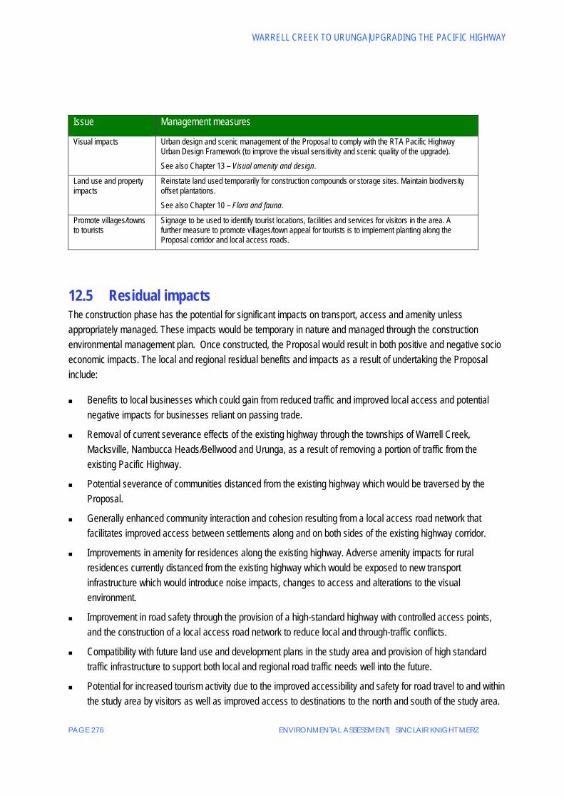
Table 12-2 Operational stage management measures Issue Management measures
Business activity Provide appropriate signage to make users of the new highway aware of services in villages and townships including Warrell Creek, Macksville, Nambucca Heads and Urunga. Inclusion of interchanges as discussed in Chapter 6 – Description of the Proposal.
Aquaculture Undertake periodic maintenance of surface water drainage systems and permanent sediment basins as part of the RTA’s maintenance program. See also Chapter 10 – Flora and fauna and Chapter 16 – Water quality and hydrology.
Community cohesion and property access
Installation of interchanges and overpasses / underpasses for local roads in order to allow property access. Provision of local access routes across the new highway and to maintain connectivity between severed agricultural properties. See also Chapter 6 –Description of the Proposal and Chapter 11 – Land use and property.
Amenity effects, including noise impacts on communities
Provision of appropriate noise mitigation measures during the operational phase and the use of low noise pavement, noise barriers and property treatments as required. See also Chapter 14 – Noise and vibration.
WARRELL CREEK TO URUNGA|UPGRADING THE PACIFIC HIGHWAY
PAGE 276 ENVIRONMENTAL ASSESSMENT| SINCLAIR KNIGHT MERZ
Issue Management measures
Visual impacts Urban design and scenic management of the Proposal to comply with the RTA Pacific Highway Urban Design Framework (to improve the visual sensitivity and scenic quality of the upgrade). See also Chapter 13 – Visual amenity and design.
Land use and property impacts
Reinstate land used temporarily for construction compounds or storage sites. Maintain biodiversity offset plantations. See also Chapter 10 – Flora and fauna.
Promote villages/towns to tourists
Signage to be used to identify tourist locations, facilities and services for visitors in the area. A further measure to promote villages/town appeal for tourists is to implement planting along the Proposal corridor and local access roads.
12.5 Residual impacts The construction phase has the potential for significant impacts on transport, access and amenity unless appropriately managed. These impacts would be temporary in nature and managed through the construction environmental management plan. Once constructed, the Proposal would result in both positive and negative socio economic impacts. The local and regional residual benefits and impacts as a result of undertaking the Proposal include:
Benefits to local businesses which could gain from reduced traffic and improved local access and potential negative impacts for businesses reliant on passing trade.
Removal of current severance effects of the existing highway through the townships of Warrell Creek, Macksville, Nambucca Heads/Bellwood and Urunga, as a result of removing a portion of traffic from the existing Pacific Highway.
Potential severance of communities distanced from the existing highway which would be traversed by the Proposal.
Generally enhanced community interaction and cohesion resulting from a local access road network that facilitates improved access between settlements along and on both sides of the existing highway corridor.
Improvements in amenity for residences along the existing highway. Adverse amenity impacts for rural residences currently distanced from the existing highway which would be exposed to new transport infrastructure which would introduce noise impacts, changes to access and alterations to the visual environment.
Improvement in road safety through the provision of a high-standard highway with controlled access points, and the construction of a local access road network to reduce local and through-traffic conflicts.
Compatibility with future land use and development plans in the study area and provision of high standard traffic infrastructure to support both local and regional road traffic needs well into the future.
Potential for increased tourism activity due to the improved accessibility and safety for road travel to and within the study area by visitors as well as improved access to destinations to the north and south of the study area.
ENVIRONMENTAL ASSESSMENT| SINCLAIR KNIGHT MERZ PAGE 277
CHAPTER 12|SOCIAL AND ECONOMIC
Potential negative impact on tourism activity and tourist related businesses as a result of reduced patronage from through-traffic.
Potential for improved local economic activity due to a combination of the above changes.

WARRELL CREEK TO URUNGA|UPGRADING THE PACIFIC HIGHWAY
PAGE 278 ENVIRONMENTAL ASSESSMENT| SINCLAIR KNIGHT MERZ
This page is intentionally blank