Walton Basin - Clwyd-Powys Archaeological Trust · · 2015-08-04This book may not be reproduced...
41
Walton Basin archaeology and conservation Bill Britnell THE CLWYD-POWYS ARCHAEOLOGICAL TRUST
Transcript of Walton Basin - Clwyd-Powys Archaeological Trust · · 2015-08-04This book may not be reproduced...

Walton Basinarchaeology and conservation
Bil l Bri tnel lTHE CLWYD-POWYS ARCHAEOLOGICAL TRUST

Contents
5 Introduction
9 The setting
11 Prehistoric lithic scatters
13 Neolithic enclosures
38 Middle and Later Neolithic settlement
41 Neolithic and Bronze Age round barrows
47 The Four Stones and other standing stones
49 Ditched enclosures and Iron Age hillforts
55 Roman marching camps and signal station
59 Roman fort and civil settlement
63 Dykes and early settlements
67 Medieval castle, walled town and market
71 Mottes, manors and moats
75 Laterfieldsandfarms
79 Archaeology and conservation
Published with the help of grant aid from Cadw – Welsh Government
Published by The Clwyd-Powys Archaeological Trust, 41 Broad Street, Welshpool, SY21 7RR
Text © Clwyd-Powys Archaeological Trust, 2013Images © See captions
All rights reserved. This book may not be reproduced in whole or in part, in any form without written permission from the publishers.
Design and typesetting: Bill BritnellPrinted by WPG Ltd

4 5
Aerial view of the Walton basinThe Walton Basin viewed from the west in 2006 with New Radnor in the foreground and the hills of Herefordshire in the far distance. To the right is the modern A44 to Kington and to the left the road to Knighton. The curving line between them is a lane which follows the course of the medieval road to the east of New Radnor, corresponding in part to the course of the Roman road which connected central Wales to the Roman Empire. Photograph: © Crown Copyright, RCAHMW, AP-2006-3672.
IntroductionThe Walton basin is a natural amphitheatre surrounded by hills on the borderland of England and Wales, between the towns of New Radnor, Powys, and Kington, Herefordshire. To the casual eye there is little, apart from the stunning scenery, that is remarkable about the landscape. However, the discoveries made here in recent decades have brought to light a story of human history spanning many millennia that is virtually unparalleled in such a relatively small area. The sites that we now know of include a Neolithic causewayed enclosure, cursuses, palisaded enclosures and ring-ditches, Bronze Age burial mounds, a stone circle and standing stones, Iron Age hillforts and camps, Roman marching camps, fort, civil settlement and roads, early medieval church settlements, a stretch of Offa’s Dyke, medieval mottes and the medieval town and stone castle at New Radnor. Many of the sites lie hidden in the ground, which means that much of the history of the Walton basin has had to be pieced together from glimpses of evidence gleanedfromfieldwalking,aerialsurvey,geophysicalsurvey,groundsurveyandtrial excavation.
The inspiration for this booklet emerged from a recent study of the archaeology of the basin by the Clwyd-Powys Archaeological Trust (CPAT), grant-aided by Cadw – Welsh Government, which has focused on issues relating to the conservation of archaeological sites within this living agricultural landscape. The modern landscape is merely the most recent in the basin’s history but hopefully this can be managed in a way which, even with modern machinery, will not erase all memory of the past.
Survey and excavation in the basinTop right: Aerial archaeologist Chris Musson (right) and the late Bob Jones, pilot, who have been active in recording sites in the basin since the 1970s. Middle: archaeologist Richard Hankinson of CPAT carrying out geophysical surveying with a fluxgate gradiometer at the Womaston causewayed enclosure in 2008. Bottom right: archaeologists Ian Grant and Sophie Watson of CPAT at work on the trial excavations at the Hindwell Roman civil settlement in 2012.

6 7
This booklet aims to provide an up-to-date summary of what we know about the archaeology of the Walton basin, focusing on the things that have been learnt since the publication of Alex Gibson’s popular booklet – The Walton Basin, Powys, Wales. Survey at the Hindwell Neolithic Enclosure, published by the Trust in 1999 – which is now long out of print. The present booklet tries to highlight how we can learn about the past, and why we feel that knowing about the past is significant.Inputtingtogetherasummaryofthiskindthereisalwaysthedangerof giving the impression that we now know as much as there is to know about the history of the area. In reality we have still barely scratched the surface, literally and metaphorically. New and exciting discoveries are continuing to emerge from the ground beneath our feet.
A number of themes run through the history of the valley. One is the way in which people returned to the same spot time and again throughout history. Why, for example, are all the Neolithic palisaded enclosures at Hindwell and Walton, directly overlain by Roman forts and marching camps dating to thousands of years later? It is also interesting to speculate about how what we know was happening in the basin at different periods relates to the exploitation of surrounding uplands. Undoubtedly, part of the reason why the basin was so special in antiquity is that it lay on an important routeway into the heart of Wales. Journeys through this corridor began in the stone age with hunter-gather groups pursuing migrating herds of deer and cattle. This raises the question of when the momentous transition from nomadic to sedentary ways of life took place, and whether some of the earliest and most impressive Neolithic monuments were in fact built by large gatherings of people who were only here at certain times of year.
Reference numbers given in the textBold numbers appearing in the text refer to the record numbers of sites listed in Archwilio, the online version of the Clwyd-Powys Historic Environment Record which can be accessed at www.archwilio.org.uk and provides further information and references to the sites mentioned.
Access to sites mentioned in the textNote that most of the sites mentioned in the text lie on private land. Unless there is public access the landowner’s permission is needed before visiting a site.
AcknowledgementsThanks must be given to a number of individuals and organizations who have contributed to the work mentioned here: excavation, fieldwork and ground survey by Nigel Jones of CPAT and Dr Alex Gibson formerly of CPAT and now Senior Lecturer, University of Bradford; geophysical survey by Richard Hankinson (2010–12) of CPAT and Dr Helmut Becker (1998); aerial photography by Dr Alex Gibson and Nigel Jones of CPAT, Chris Musson formerly of CPAT and latterly of the Royal Commission on the Ancient and Historical Monuments of Wales (RCAHMW), Dr Toby Driver of RCAHMW, and the late Dr J. K. St Joseph of Cambridge University; images used in this booklet mostly belong to CPAT, but thanks are also due to a number made available by courtesy of RCAHMW, Radnorshire Museum, and Roger Whitehead, as acknowledged in the captions; help with the preparation of this booklet by Jenny Britnell and Nigel Jones. Funding for recent work has been made available by Cadw – Welsh Government. Grateful thanks must also be given to landowners who have granted access tocarryoutthefieldwork,surveyandexcavationsmentionedbelowandforthesupportandencouragement of local communities and bodies such as the Radnorshire Society.
View in 2008 from the Womaston Neolithic causewayed enclosure on the eastern side of the basin towards the hills of the Radnor Forest whose summit lies about 10 kilometres away to the west. Photograph: CPAT 2627-0032.
Letter from William Wordsworth at Hindwell House to Mary Wordsworth at Grasmere, 19 August 1810
‘It is a Country of many Vales, this in which Hindwell stands, the longest and widest; but the narrowest vales and the narrow parts of the wide ones are the most pleasing portion of the country. Hindwell House stands very pleasantly however, on account of the Pool in front, and the Hill opposite crowned by old Radnor church . . . it stands in part of the Vale more than three miles across and comparatively naked, large fields and poor Hedgerows; but the view from the windows is truly delightful, and shews beautifully the great importance of still water in Landscape. By moonlight and in the evening this Pool of three acres, seen from the window with its reflection is little less interesting than on of our Lakes.’

8 9
Natural and administrative boundaries in the Walton basinIn non-archaeological contexts the basin is better known as the Radnor Valley or the Vale of Radnor. The map shows the extent of the study area in this booklet, the extent of late glacial terraces, and modern political boundaries. Most of the area falls within the communities of Old Radnor and New Radnor in the modern Welsh county of Powys, created during local government reorganization in 1974. It formerly lay in the county of Radnorshire, created from earlier lordships by the Laws in Wales Acts 1535–1542, with New Radnor as its original county town. The national boundary between England and Wales crosses the lower right-hand corner of the study area.
The setting The low-lying Walton basin lies at about 200 metres above sea level and is enclosed by hills which in the case of the Radnor Forest to the west rise steeply to heights of up to 600 metres within a short distance from the valley edge.Thefloorofthevalleygentlyundulatesandhasalowbutdistinctcentral ridge midway between the Summergil Brook and the Knobley Brook, being composed of glacial clays and gravels. There are distinctive terraces several metres high, particularly along the Summergil Book, that were probably created by the action of glacial meltwater. Aerial photographic evidence suggests that early braided watercourses eventually gave way to the present-day drainage pattern of streams during the late glacial period, though it seems from the relationship of streams to archaeological sites that their courses were still subject to dynamic change well into the prehistoric period, perhaps as the clearance of the natural post-glacial woodland led to increased run-off and renewed stream erosion.
a
b
c
d
Streams and springsDuring the summer months the Summergil Brook, the principal stream crossing the valley, often dries up near New Radnor (the end of the stream name being derived from the Old English gelde, meaning ‘barren’). Groundwater wells up again in a series of springs on the far side of the valley near Hindwell Pool (presumably a place once frequented by deer) – the source of the Hindwell Brook, which continues to flow all year. In antiquity these pools must have formed an important water supply on the eastern side of the valley, giving rise to the local folk tale which tells of the stones of the Four Stones stone circle going down to drink from the pool at night. a Summergil Brook in winter, carrying water from the Radnor Forest and the distinctive peak of the Whimble in the far distance. b Dried up bed of the Summergil Brook in summer. c Hindwell Pool fed by a spring at the source of the Hindwell Brook. d The Hindwell Brook, a tributary in turn of the Herefordshire Lugg, Arrow and Wye, seen here looking eastwards towards Herrock Hill.

10 11
Some characteristic lithic types from the Walton basina Late Upper Palaeolithic shouldered point, about 10,000 BC found in New Radnor during excavations in 1991; b Earlier Mesolithic obliquely blunted point, 9600–6000 BC; c Later Mesolithic microlith, 6000–4000 BC; d Early Neolithic leaf-shaped arrowhead, 4000–3000 BC; e Later Neolithic (or Mesolithic) chisel arrowhead, 3000–2300 BC; f Early Bronze Age barbed and tanged arrowhead, 2300–1500 BC. Scale 2:3.
Prehistoric lithic scattersNumerouslithicartefactsandwastematerialhavebeenfoundduringfieldwalkinginthebasinsince the 1950s. None of the raw materials that were used occur naturally in the basin and were clearly brought here, and therefore provide direct evidence of human activity. The distribution ofthefinds,shownopposite,isimportantindefiningareasofactivityinthebasinduringtheearlierprehistoricperiods.Mostofthefindsareofflintbuttherearealsosomemadeofchertandfine-grainedrocks,includingsomereworkedfragmentsofbrokenNeolithicflintandstonepolishedaxes.Mostoftheflintisofgoodqualityandincludessomedistinctivetypesofmaterial whose source can be traced to areas such as the Berkshire Downs, the Chilterns, Kent and Essex area, and Lincolnshire.
Althoughmanyofthefindsarewastematerialdiscardedduringmanufactureandnotcloselydatable, a reasonable proportion belong to recognizable artefact types such as those shown on the right, that can be dated to particular periods. These show a sequence of activity over a period of many millennia from the Late Upper Palaeolithic period in about 10,000 BC up to at least the end of the Early Bronze Age in about 1500 BC.
Theearliestlithicfindsfromthebasinwereleftbynomadicgroupsofhunter-gatherersmovingbetween uplands and lowlands in pursuit of migrating herds of deer and wild cattle. The latest findsweremostprobablyleftbysettledfarmers.Itislikelythatearlierprehistoricsettlementswithin the basin, whether temporary or permanent, involved lightly-built timber structures of a kindthatcanbedifficulttodetectandwhicharelikelytobevulnerabletointensivecultivation(seepages38–40).Thefindsfromtheploughsoilarethereforeimportantinindicatingareasoftheearliesthumanactivityinthebasin.Accuratelyrecordingwherethefindscomefromisvitally important.
Lithic scatters in the Walton basinOver 8,000 lithic finds have been found at more than 200 locations in the basin ranging in quantity from single finds to as many over 1200 pieces. Of the material that can be dated to a particular period, Late Upper Palaeolithic finds are known from one location, Mesolithic material is known from about 20 locations, and Neolithic and Bronze Age material from about 30 locations each. The material from many of the locations is of more than one period, which makes it difficult to plot the density of lithics belonging to any one period, though there seem to be no marked differences in the distribution of material of different periods. The extent to which the distribution of artefacts reflects the extent of modern arable agriculture (see page 74) is uncertain.

12 13
Neolithic enclosures
The earliest and most remarkable element of the palimpsest of archaeological sites in the Walton basin is the cluster of eight or perhaps nine Neolithic enclosures, described in the following sections, that were built between about 3800 BC and 2300 BC. The types of sites that are represented are well known elsewhere in Neolithic Britain and include a causewayed enclosure, two cursus monuments (one of which is amongst the longest such monuments in Britain), a double pit alignment, three or possibly four palisaded enclosures (including the largestenclosureknowninBritain),andfinallyanunusuallylargepenannularring-ditch,approaching the diameter of the earthwork encircling Stonehenge.
None of these remarkable sites remain visible at ground level today, and what we know of them is largely a result of aerial photography and geophysical survey carried out over many years which is gradually allowing us to piece together a picture of what lies hidden in the ground. Some of these monuments are truly enormous. It would take almost an hour, for example, to walk from one end of the Hindwell cursus to the other, and the Hindwell palisaded enclosure whichsupersededitwouldreadilyaccommodatetheequivalentoffiveOlympicstadiums!Acrude measure of the effort involved can be gained by calculating the weight of earth and/or timber that had to be shifted. The Hindwell cursus, for example, is likely to have involved the excavation of over 90,000 tons of gravel. The construction of the Hindwell palisaded enclosure would have required the excavation of over 6,700 tons of gravel for the palisade trench and the felling, dressing, transport and erection of over 3,300 tons of timber.
TheenclosureswerebuiltduringtheperiodthatfarmingwasfirstintroducedintoBritainbut the role they played in the transition from hunter-gathering to more sedentary lifestyles based upon agriculture is uncertain. The purpose of the enclosures is also unclear though none appear to have been directly associated with settlement. The construction of at least the larger monuments is likely to have involved large gatherings of people, probably numbering many thousands. The clustering of monuments on the eastern side of the valley suggests this area was reserved for special activities and resembles a long-lived tribal cult centre. Settlement evidence and lithic scatters (see pages 10–11, 38–39) suggests that the focus of settlement activity during the periods in which the monuments were in use lay slightly to the west, though it is uncertain whether people were permanently settled here or whether, as seems more likely, tribal gatherings only assembled on certain occasions or at certain seasons of the year.
Neolithic enclosures in the Walton basinThe Neolithic enclosures are clustered on the eastern side of the basin. It appears significant that although the two cursuses have different topographical settings they share a similar alignment which may have astronomical significance. The palisaded enclosures appear to have a close relationship with springs and streams. The Hindwell palisaded enclosure, for example, partly encompasses Hindwell Pool, the source of the Hindwell Brook. 1 Womaston causewayed enclosure; 2 Walton Green cursus; 3 Hindwell cursus; 4 Walton palisaded enclosure; 5 Walton double pit alignment; 6 possible Walton double or treble-palisaded enclosure; 7 Hindwell palisaded enclosure; 8 Hindwell double-palisaded enclosure; 9 Walton Court ring-ditch.
Above: Neolithic flaked and polished stone axe found during fieldwalking south of Rough Close. Flint and stone axes of this kind were hafted in a wooden handle and used for felling trees and general carpentry. Similar axes would have been used for the preparation of timber for the Walton and Hindwell palisaded enclosures. Scale: 2:3.

14 15
Although the monuments vary considerably in size and shape the fact that they are clustered together suggests changes in customs or cult practices linked by some as yet elusive common thread. Despite the period of up to about a millennium and a half during which the monuments were built a new piece of ground was evidently chosen each time. The only certain overlap is that between the Hindwell cursus and the Hindwell palisaded enclosure, though the relationship is fairly tangential and even here it appears that the ditches of the cursus might have been deliberatelyinfilledbeforethepalisadedenclosurewasconstructed.Therelationshipbetweenthe undated Walton pit alignment and the Walton palisaded enclosure, assuming they are different monuments, also appears to be tangential. This implies both the earthwork monuments (such as the causewayed enclosure, cursuses and large ring-ditch) and the timber monuments (the palisaded enclosures and pit alignment) remained visible in the landscape for many centuries after they were built and abandoned, despite the inevitable weathering of ditches and the gradual decay of the timber posts, suggesting that the site of each monument continued to be revered as hallowed ground.
There are hints of seasonality in the orientation and location of certain of the monuments. Further research is needed, but the two cursus monuments appear observe the approximate direction of sunrise somewhere between the May Day and Midsummer Day – the Welsh Calan Mai and Gŵyl Ifan – both of which were days upon which celebrations were traditionally held. The principal stream crossing the basin is the Summergil Brook. Despite being fed by permanent streams cascading from the Welsh hills, the stream dries up in all but the wettest summers,disappearingintothegravelfloorofthe western side of the basin before welling up again in a series of springs near Hindwell Pool on the east, around which the palisaded enclosures are clustered. The pool is the source of the never-failing Hindwell Brook. There aremorespecificassociationswithwaterthatalsoappearsignificantbutwhichareasyetunexplained. The Hindwell cursus crosses the Summergil Brook and Knobley Brook whereas the Walton Green cursus seems to be set out
Below: This lane near Hindwell Farm follows the curve of the northern side of the Hindwell Neolithic palisaded enclosure, clearly showing that the site of the enclosure must have remained visible in the landscape for centuries or millennia after its posts had been burnt down or rotted away. In the far distance lie the hills of the Radnor Forest with the distinctive peak of the Whimble to the left.
along the Riddings Brook. The Hindwell palisaded enclosure must have enclosed the spring at Hindwell Pool, though its southern side may be set out in relation to the Summergil Brook. The Hindwell double-palisaded enclosure was either crossed by or followed the edge of the Summergil Brook. And the Walton palisaded enclosure and the possible Walton double or treble-palisaded enclosure were likewise either crossed by or butted up against the Riddings Brook. Further study of this and other aspects of the environment in which theenclosureswerebuiltonthefloorofthebasinisneeded,butthereisgrowingevidencethatthefloorofthevalleyatthistimewas predominantly shrubby grassland, with some evidence of cereal cultivation, which suggests that timber for the palisaded monuments may have been brought in from the slopes around the edge of the basin. The digging of vast earthworks and the felling of large quantities of timber may itself have contributed to increased run-off of surface water and increased stream erosion.
The clustering of monuments on the eastern side of the basin clearly points to a sequence which developed over a period of about 1500 years between the early fourth millennium and the mid third millennium BC. New monuments were built which carefully observed what had gone before. The construction of the monuments, as argued above, most probably involved tribal gatherings, perhaps on a seasonal basis. Despite the radical changes in the form of the enclosures there are implications that these relate to changing customs that were in some way associated. Circumstantial evidence hints that this may have had something to do with the cyclical movement of the sun, the changing seasons, the availability of water, and perhaps the movement of livestock between upland and lowland.
Upland and lowlandAncient trackways, below, on the edge of the Radnor Forest showing up in winter snow. The trackways have resulted from the movement of stock reared on the upland pastures of Wales to English markets and are now practically the only visible trace of the once substantial export trade in animals on the hoof carried out by Welsh drovers into the late 18th and early 19th centuries. Because of the siting of the Walton basin on the margins of upland Wales it is interesting to speculate whether the movement of domesticated animals between the uplands and lowlands began during prehistory and whether this was in some way associated with the construction of the Neolithic enclosures that were constructed here. Photograph: CPAT 92-C-0516.

16 17
Left: Aerial view of the Womaston causewayed enclosure from the north-east. Cropmarks were first recorded here in 1970 but it was only when the site was photographed from the air again in July 2006 that its identification as a Neolithic causewayed enclosure first became clear. The buried ditches show up as darker marks in the cereal crop in the field towards the centre and the left, but are largely invisible in the grassland at the top and bottom. Photograph: © Crown Copyright, RCAHMW, AP-2006-2199.
The Womaston Neolithic causewayed enclosureThe site occupied the knoll in the middle distance which rises about 25 metres above the valley floor and is probably a glacial drumlin. The trial trench being excavated in 2008 can be clearly seen at a distance, emphasizing how visible the ditches and banks of the enclosure may once have been. In the background is the Gore Quarry on Old Radnor Hill. The tower of St Stephen’s Church, Old Radnor, is just visible to the right. Photograph: CPAT 2627-0067.
Womaston causewayed enclosure
The Womaston causewayed enclosure (53996), which lies about midway between Evenjobb and Walton, is one of the earliest Neolithic sites in the Walton basin. It occupies a slight knoll which represents one of the few prominent landmarks in the valley bottom, with panoramic views of almost the entire basin. Similar Neolithic enclosures are known elsewhere in southern Britain and are thought to have been used for seasonal gatherings rather than as permanent settlement sites and often appear to have been sited on the margins of areas where people were living. Only a handful of similar sites are known in Wales. Plant remains recovered from the site included cereal grains which suggests that the people that built the enclosure were engaged in agriculture here or elsewhere. Radiocarbon dates for charcoal found in the ditches suggest that it was built in the period between about 3700 BC and 3300 BC. This shows that it is earlier than the palisaded enclosures described below, but it is uncertain whether it was in existence at the same time as the Walton Green and Hindwell cursus monuments which are described next.
Womaston causewayed enclosureLeft: Partial plan of the Womaston Neolithic causewayed enclosure plotted from aerial photographs and geophysical survey. The enclosure is 180 metres by 130 metres across and covers an area of 1.8 hectares. It had two roughly concentric lines of interrupted ditches between about 5–14 metres apart, and has a possible entrance on the southern side where the inner ditch turns sharply inwards. The ditches would originally have been accompanied by discontinuous banks which have since been levelled by ploughing. The excavations also revealed a pit that had been dug in the interior of the site during the Iron Age.

18 19
Womaston causewayed enclosureView of the trial trench excavated across the inner and outer ditches of the Womanston causewayed enclosure by CPAT in 2008. This showed that the inner and outer ditch segments had U-shaped profiles about 2.5 metres across and up to 1.8 metres deep, with evidence of recutting suggesting a number of periods of activity. The excavations produced sherds of Early Neolithic pottery and a few lithics. A significant number of lithics were also recovered from the surface of ploughed fields in the area in the 1950s which most probably came from the site. Photograph: CPAT 2627-103.
Below: Rim sherd from a Neolithic round-bottomed ceramic bowl found during trial excavations at the Womaston causewayed enclosure. Scale 1:1.
Left: Members of the Radnorshire Society during their visit to the Womaston causewayed enclosure during the trial excavations in August 2008.
Left: Butt-end of one of the inner ditch segments during the course of excavation in 2008. Gravel dug from the ditches was probably used to construct intermittent banks on the uphill side of the ditches that have been subsequently levelled by ploughing. Photograph: CPAT 2627-126.

20 21
Walton Green cursusOverall plan of the monument plotted from aerial photographs. The relationships of the cursus to the three small rectilinear enclosures which lie along its length and to a further enclosure and a round barrow just beyond its western end are unknown but suggest that the cursus was still visible when they were dug. The small enclosures are between about 50–80 metres across.
Below: Reconstruction of how the Walton Green cursus
may have appeared, viewed from the west and looking towards the gap taken by the Hindwell Brook between Burfa Hill and Herrock Hill. Image: Courtesy of Radnorshire Museum.
Walton Green and Hindwell cursuses
These two elongated ditched enclosures belong to a type of Neolithic monument which is familiar from a number of widely scattered sites throughout Britain, though the Hindwell cursus belongs to a select group of exceptionally large monuments and is potentially the second or third longest cursus known in Britain. The purpose of these monuments is obscure, but they are thought to have had a ceremonial function, perhaps as processional ways. Monuments of this kind sometimes have gaps or entrances in the sides or ends and earth dug from the ditches was probably used to make banks on the inner side. The shorter Walton Green cursus has yet to be closely dated, but radiocarbon dates suggest that the Hindwell cursus was built during the period between about 3900–3500 BC, so it is unknown whether they were built or were in use at the same time. The landscape setting of the two sites is quite different. The Walton Green cursus lies parallel to the valley side and seems to be aligned on the eastern entrance to the valley. The Hindwell cursus acts more like a barrier, dividing the valley into two. The two cursuses share is a similar orientation, however, which may have astronomicalsignificance.
Walton Green cursusThe Walton Green cursus (5134) lies on fairly level ground hugging the southern edge of the valleyfloorbetweentheRiddingsBrookandthe base of slopes rising southwards to Stanner Rocks just to the east of Walton village. The cursus is 673 metres long with side ditches up to 58 metres apart and roughly squared terminals. It encloses an area of about 3.6 hectares and has the appearance of being orientated on the eastern entrance to the valley. Trial trenches excavated by CPAT at the east end in 1998 showed that the ditches were between up to 3 metres wide and about 0.8 metres deep with evidence of an entrance causeway at the east end. The only datingevidencewasaNeolithicflintscraperfromtheupperditchfill.
Left: Aerial photograph taken in 1996 of a middle section of the cursus where it coincides with one of the small ditched enclosures of unknown date. The first indication that the monument existed was from cropmarks recorded by aerial photography in 1979. Due to crop rotation not all of the cursus is visible in any one year and its plan has therefore had to be gradually pieced together from aerial photographs taken in successive seasons. Photograph: CPAT 96-c-0026.

22 23
Hindwell cursus The combined evidence obtained from aerial photography, geophysical survey and trial excavations suggests that the Hindwell cursus (33109) forms a single monument running for a distance of 4,660 metres across the full width of the Walton basin, from just to the south of Harpton Court at the south-western end to Evenjobb Hill to the north-east, crossing the course of the Knobley Brook and Summergil Brook on its way. The apparent length of the cursus places it in a small group of extremely long British cursuses.
The plan of the monument is still far from complete, however, and only about a quarter of bothditcheshavesofarbeenpositivelyidentified.Incommonwithothercursusmonuments,there is some variation in the distance between the ditches, which are 63 metres apart at the north-east terminal, and between 54 metres and 74 metres apart elsewhere, enclosing an area of perhaps 27 hectares. Sections excavated across the two ditches indicate that they are up to 3.9metreswideand1.8metresdeep,withsteeplyslopingsidesandaflatbase.Thepatternofsilting in fully excavated ditch sections suggests that the accompanying banks were more likely to have been on the inside.
Radiocarbon dates for charcoal from the excavated sections of the cursus ditch suggests a date of construction in the period after about 3900–3500 BC. Trial excavations at the intersection of the northern ditch of the cursusandtheHindwellpalisadedenclosurein2011confirmedthatthecursus was the earlier of the two, with suggestions that the cursus ditches hadbecomecompletelyinfilledwithrelativelycleangravel,deliberatelyor otherwise, by the time the palisade was constructed. Two round barrows fall within the line of the cursus, the Hindwell Farm barrow II (309) and the Hindwell Ash round barrow (307), further to the north and partially excavated in 1993. The relationship of the barrows to the cursus is unknown though the barrows are both assumed to be later in date. Charred plant remains from the cursus ditches include grass rhizomes, vetch and cinquefoil, in addition to hazelnuts, apple pips and fragments of acorn shell. This, combined with the general scarcity of wood charcoal and an absence of cereals suggest that it was built in a predominantly shrubby grassland environment and not directly associated with settlement activity.
Below: Trial section across the north ditch of the Hindwell cursus, excavated in 2010, viewed from the south, looking toward the Radnor Forest. The ditches are much larger than is usual for Neolithic cursuses Photograph: CPAT 3191-0039.
Below: Tentative plan of the Hindwell cursus. Like the Walton Green cursus its plan has been gradually pieced together from aerial photographs taken between 1967 and 2011, supplemented with geophysical survey at the possible south-western terminal.
Hindwell cursus crossing the floor of the basinActive erosion scar on the dried-up bed of the Summergil Brook at about the point where it is crossed by the Hindwell cursus. View looking north-eastwards across the valley bottom towards Evenjobb Hill, where the cursus terminates at the foot of the slope. Photograph: CPAT 3608-0073.

24 25
View across the basinThis view across the basin in 2011 is from a position near the assumed south-western end of the cursus towards the site of the north-eastern terminal on the edge of Evenjobb Hill, about 4.6 kilometres away. Photograph: CPAT 3608-0066.
Top left: Aerial photograph of part of the middle section of the Hindwell cursus in 2011, on the near side of Four Stones Farm, visible towards the centre. The two ditches at this point are about 62 metres apart. The Four Stones stone circle (arrowed) lies to the left of the road junction just above the farm. The supposed southern terminal lies about 1.7 kilometres to the left. The northern terminal of the cursus (see below) lies about 2.6 kilometres to the right.
Northern end of the cursusAt its northern end the Hindwell cursus stops on sloping ground, about half-way across this field, just before the point at which the slope of the hill becomes much steeper. The view here, taken in 2011, looks in the direction of Evenjobb, with the lane to Ditchyeld Bridge just to the left. Photograph: CPAT 3608-0001.
Bottom left: Cropmarks showing the northern terminal of the Hindwell cursus in April 2011. The two ditches at this point are about 63 metres apart and there are hints of an entrance gap in the middle of the end. Cutting across the line of the cursus in the middle distance is the lane between Evenjobb and Ditchyeld Bridge. The other cropmark ditches that are visible are undated.
m
Photographs: © Crown copyright: RCAHMW, 2011-1174 and 2011-1189.

26 27
Below: The palisaded enclosures had been built in slightly different ways. The Walton enclosure had more widely-spaced posts set in separate pits with post ramps a. The large Hindwell enclosure was built of less widely-spaced posts set in intercutting pits, again with post-ramps. The Hindwell double-palisaded enclosure was built of close-set posts set in continuous, steep-sided foundation trenches b.
Walton and Hindwell palisaded enclosures
The Walton palisaded enclosure and the two Hindwell palisaded enclosures lie close together on the eastern side of the basin. Similar Neolithic palisaded enclosures are known to have been built at other centres elsewhere in Britain but the Walton basin enclosures form the most impressive known complex. Covering 34 hectares, the Hindwell enclosure is by far the largest Neolithic palisaded enclosure known in Britain.
Traces of the original posts are clearly visible in the ground where they have rotted away or been burnt. Charcoal from burnt or charred posts indicates that the posts were of oak. For the sake of stability posts normally have to be set up to a third of their depth in the ground, which suggests that each of the palisades stood to 4 metres or more above ground level. Radiocarbon dates suggest that the three enclosures were built in the period between about 2800–2400 BC, possibly in sequence.
Only a small proportion of the palisades of the Walton enclosure and the two Hindwell palisaded enclosures have been excavated, and none of their interiors. Their purpose remains unclear. It is uncertain, for example, whether the posts were simply freestanding or whether they supported a continuous barrier, though in the case of the Hindwell enclosure at least one entrance is known, represented by a wider spacing between the posts. Only parts of the plan of each enclosure is known and it is also uncertain whether the palisades were continuous or open ended. There are hints of internal and external structures but the dating of these is unknown.
Also considered here are two unexcavated sites, the Walton double pit alignment, next to the Walton palisaded enclosure, which may also have had standing posts, and a possible double or triple-palisaded enclosure to the west of the Walton palisaded enclosure. If this possible palisaded enclosure is real it may suggest a pairing of monuments, with the Hindwell cursus and the two Hindwell palisaded enclosures to the north of the Summergil Brook and the Walton Green cursus and two palisaded enclosures to the south of the brook, despite the fact that the monuments were not all built at the same time.
Walton palisaded enclosureThe Walton palisaded enclosure (4255) enclosure lies on reasonably level groundbetweentheSummergilBrookandtheRiddingsBrookandwasfirstdiscovered from the air in 1975. It lies about 300 metres to the south of the Hindwell palisaded enclosures and about 500 metres to the west of the Walton Green cursus. It consists of a curving arc of pits just over 400 metres long, spaced at intervals of about 6 metres. A double pit alignment on its western side (see page 30) is now thought to be a separate monument. Geophysical survey, undertaken in 1995, 2009 and 2010 hints that the enclosure may extend for at least a further 100 metres or more to the east. At present, the minimum dimensions of the enclosure are about 200 metres by 280 metres across, enclosing an area of more than 5 hectares. The relationship of the enclosure to the course of the Riddings Brook is uncertain, but it might have been open to both the south and east. Single post-pits on the northern side of the enclosure were excavated in 1998 and 2010. The pit excavated in 1998 was 4.3 metres long and 2 metres wide, with a post-ramp on the south-west side for a post 0.4 metres or more in diameter, set up to 1.3 metres into the ground. The adjacent pit excavated in 2010 was 1.1 metres in diameter and up to 2 metres in depth with a post-ramp about 3.6 metres long and up to 1.5 metres deep again on the south-west side, for a post up to 0.7 metres in diameter. Assuming that the plan of the monument was symmetrical, construction would have required at least 200posts,inadditiontothediggingandrefillingofthepostpitsandramps.Theupperfillofthepost-pipehadaweatheringcone,whichsuggeststhattheposthad rotted in situ. Radiocarbon dates for charcoal from the post pits suggest that the monument was built between about 2800 BC and 2300 BC.
Walton possible double or triple-palisaded enclosureA pattern of concentric curving cropmarks (33130) recorded by aerial photography hints at the existence of a double or possibly triple-palisaded enclosure about 180 metres to the west of the Walton palisaded enclosure and bisected by the Riddings Brook (see page 29). The site is unexcavated but the cropmarks might represent continuous foundation trenches for palisades similar to those at the Hindwell double-palisaded enclosure, in this instance set about 20 metres apart. The setting of the site suggests that it may have been up to about 300 metres across and enclosed an area of up to about 5 hectares.
Below: One of the massive post-pits of the Walton palisaded enclosure, excavated in 2010, looking eastwards towards Burfa Bank. The dimensions of the original post placed in the pit could be determined from the pattern of silting which had formed after the post had gradually rotted away. The post-pit is dug into gravel and has a post ramp on the near side which shows that the post was erected from the western side. Photograph: CPAT 3045-0026.

28 29
Walton palisaded enclosure and pit alignment Left: Plot of part of the complex of cropmark sites that have been identified by aerial photography since the 1960s just to the west of Walton, illustrating some of the difficulties of interpretation. So far, the only sites whose dating is known are the Walton Neolithic palisaded enclosure, dating to about 2800–2300 BC, the Walton Court Farm ring-ditch (see page 36), dating to about 2500–2300 BC, and the three Roman marching camps probably dating to the period between AD 55–80 (see page 56).
Possible Walton double or triple-palisaded enclosureRight and above: The possible Walton double or triple-palisaded enclosure (33130) is represented by cropmarks in the field next to Riddings Brook, visible in the aerial photograph to the right taken in 1996. The site is unexcavated but the cropmarks resemble the concentric palisade trenches of the Hindwell double-palisaded enclosure (see plan on page 34). If this interpretation is correct, the enclosure would have straddled Riddings Brook. To the right of the photograph are the cropmarks of the 27 metre diameter double ring-ditch of Walton ring-ditch I (365). Photograph: CPAT 96-c-0018.
Cropmarks of part of the Walton palisaded enclosure seen from the south-west in 1979 with the hamlet of Walton to the right. The postholes of the northern sector of the palisaded enclosure show up in ripening corn, crossed by two of the three Walton Roman marching camps. Photograph: CPAT 79-ck-0006.
Walton palisaded enclosureReconstruction of the Walton palisaded enclosure from the west, looking towards the gap between Herrock Hill and Burfa Hill, with the site of the Walton Green Neolithic cursus just beyond the palisaded enclosure. Image: Courtesy of Radnorshire Museum.

30 31
Walton double pit alignmentA double row of pits (5295) extending beyond the western sideoftheWaltonpalisadedenclosurewasfirstidentifiedfrom the air in 1975 at the same time as the palisaded enclosure and has been thought to be part of the same monument. Reconsideration of the cropmarks now suggests that they are two separate monuments though it is uncertain which might be the earlier. There is no obvious gap in the arc of posts of the palisaded enclosure at this point though the tangential relationship of the two monuments suggests a relationship of some kind between the two. The alignment is slightly bow-sided, orientated approximately east-west and covers an area of abut 550 square metres. It is about 57 metres long, with pits about a metre in diameter at intervals of about 4 metres set in two rows between 9 and 10 metres apart, possibly with 15 pits on each side. The extreme north-eastern pit possibly coincides with a pit in the palisaded enclosure. There are possibly two additional pits set slightly inside and across the western end. It is assumed that the pits represent lines of posts but this has yet to be confirmedbyexcavation.
Hindwell palisaded enclosureThe Hindwell palisaded enclosure (19376) covers an area of about 34 hectares, making it by far thelargestsuchsiteinBritain.Partsoftheenclosurewerefirstrecordedfromtheairin1969butthesizeandsignificancewasnotfullyappreciateduntilitswesternsidewasidentifiedfromthe air in the mid 1990s. Several programmes of geophysical survey have been undertaken, commencing with a number of small areas in 1995 followed by more extensive survey work in 1998.
The enclosure forms an oval at least 750 metres long and up to 540 metres wide with its long axis aligned approximately north-west to south-east, encompassing Hindwell Pool, the spring formingthesourceoftheHindwellBrook.Itliesonflattishground,slopinggentlydownwardsto the east, though on the southern side it drops down several metres over the edge of a probably late glacial terrace, before possibly mirroring the course of the Summergil Brook. Excavations in the mid 1990s have shown that the palisade was constructed of oak posts
Top left: Plan of the pit alignment in relation to the Walton palisaded enclosure. Bottom left: Aerial photograph of the alignment and nearby ring-ditch viewed from the east in 1999. The post-pits of the palisaded enclosure do not show up clearly in this photograph presumably because of soil conditions at the time the photograph was taken. The fact that both sets of posts are not visible at the same time seems to confirm suggestions that they are two separate monuments. Photograph: © Crown copyright, RCAHMW, 99-cs-1856.
Below: Plan of the two Hindwell palisaded enclosures pieced together from aerial photography and geophysical survey.

32 33
between 0.6–1.0 metres in diameter, set in post-pits up to about 2 metres deep with substantial post-ramps, the total width of post-pits and post-ramps being between 5 and 6 metres. Gaps between adjacent posts are generally about 0.8 metres, though geophysical survey suggests an entrancegapabout2metreswideatthewesternend,flankedbytwolargerposts.Geophysicalsurvey also suggests that the north-eastern arc of the enclosure may show two phases (see below right) or perhaps alternatively that the post-ramps were on the inside rather than the outside of the enclosure along this stretch. The outer faces of all the posts in the sections excavated in the mid 1990s had been charred, either deliberately or accidentally, four of which have been dated, combining to suggest a date of construction about 2700 BC. Excavations in 2011 showed that the palisaded enclosure was later in date than the Hindwell cursus (see page 23).
Currently, 1805 metres of the perimeter of the enclosure is known or can be reliably inferred, which indicates that construction would have required at least 1100 posts in addition to the digging of the intercutting post-pits and ramps. The northern side of the enclosure is followed by a lane of unknown antiquity (page 14) whose course is assumed to have followed a curving hollow visible at ground level after the posts had decayed. To the north-east the line of the
palisade trench is lost to view where it is overlain by the Hindwell Roman fort and Roman road running northwards from the fort (page 59). The enclosure is also overlain by the two Romanmarchingcamps(page55).Excavationsin2011confirmedthelineofthepalisadeon the south-east suggested by geophysical survey but its course is then lost on the edge of a prominent and probably pre-existing palaeochannel. The palisade has failed to show up on either air photographs or geophysical survey on the far side of the palaeochannel, 40 to 50 metres further east, which raises the possibility that the enclosure was open on its eastern side.
The relationship with the Hindwell double-palisaded enclosure has not yet been established. The only certain structures of antiquity inside the enclosure are two round barrows whose mounds are still visible. There are also hints from the geophysical survey of pits and a possible timber circle on its north-east side. The location of two small enclosures just outside the western side of the palisade, in the vicinity of a suggested entrance, hints that they may be contemporary with or later than the enclosure.
The western end of the Hindwell palisaded enclosure viewed from the south-east, first discovered as a cropmark in a field of ripening corn in 1994 when this aerial photograph was taken. The apparent doubling of the palisade in the foreground of the photograph is unexplained but also appears in the geophysical survey of the north-east arc of the enclosure shown on the opposite page. Also visible is one of the two small undated enclosures, both about 30 metres across, which lie just outside the palisade. Photograph CPAT 94-c-0292.
Below left: Four post-pits and ramps on the northern side of the Hindwell palisaded enclosure excavated in 1995, showing the charred outer faces of the original posts. Below right: Geophysical survey of the north-eastern arc of the enclosure in 1998 shows a about 20 posts over a length of about 55 metres of the palisade which appear to have been burnt, and b pits and a possible circular structure about 20 metres in diameter.

34 35
Hindwell double-palisaded enclosure The partial plan of the enclosure (114489) is known from geophysical survey, aerial photographyandexcavation.Partsoftheeasternsideoftheenclosurewerefirstrecordedincidentallyfromtheairin1970andfurthertraceswereidentifiedduringgeophysicalsurvey of the Hindwell Roman fort and part of the associated civil settlement in 1998; the plan of the site, its form and dating were unclear though until trial excavations by CPAT in 2011 and 2012. The two palisade trenches, which are between 25–30 metres apart, cover an area of over 6.9 hectares, measuring 300 metres by more than 250 metres across. The double-palisaded enclosure covers only 20 per cent of the area of the Hindwell palisaded enclosure, but it is interesting to note that the combined length of its inner and outer palisades was probably over 80 per cent of that of the larger enclosure. Assuming that the palisades were originally more or less continuous, construction would have required about 4500 posts, in addition to digging the foundation trenches. On the south-west the palisade trenches run along the scarp of what is almost certainly an earlier palaeochannel which slopes down markedly towards the interior of the enclosure, whilst to the north andeasttheyrunalongthecrestofaslopewhichdropsdowntowardstheconfluenceoftheHindwellBrookandasmall,un-namedstreamtothenorth.Itseemssignificantthatthe southern side of the enclosure runs more or less along the line of the Summergil and Hindwell Brooks though its original relationship with them is unclear. Was the enclosure partly open on this side or have the streams moved, to follow the line of the palisades on this side? The relationship of this enclosure to the Hindwell palisaded enclosure to the west is also open to speculation though, as noted above, there are hints that the latter may have been open on the east. Both the inner and outer foundation trenches appear to have been dug as a series of intercutting steep-sided pits which had held close-set posts, some or all of which to judge from the reddening of the soil and stones packed around the posts, appear to have been burnt in situ. Oak charcoal from the posts suggests that the enclosure was built in the period between about 2600 BC and 2400 BC, and therefore perhaps a century or so later than the Hindwell palisaded enclosure on its western side. A plain sherd of Grooved Ware, similar to the abundant material from Upper Ninepence (see pages 38–40) just over a kilometre away to the north-west, was found within the inner palisade trench, suggesting that the palisaded enclosure was contemporary with the Later Neolithic settlement evidence found there.
Left: Section excavated across the inner palisade trench of the Hindwell double-palisaded enclosure in 2012. This showed that the continuous palisade trench, at this point about 2.8 metres wide and 1.7 metres deep from the modern ground surface, had held close-set timbers about 0.35–0.4 metres across. The trenches had been backfilled with gravel once the posts had been put in place to hold them upright. The position of one of the posts, towards the centre of the trench, shows up as a darker ‘pipe’ of soil and had evidently been burnt in situ. Photograph: CPAT 3433-0233.
Left: Plan of the Hindwell double-palisaded enclosure revealed by geophysical survey, aerial photography and excavation. Below: The Hindwell Brook looking eastwards at the point where the palisade trenches meet the stream. Photograph: CPAT 3433-0184.
Below: The 5-metre survey staff shown in the photograph, placed on the bottom of the inner palisade foundation trench of the Hindwell double-palisaded enclosure, gives an impression of the height of the timbers of the original palisade. For the sake of stability the general rule of thumb is to bury the bottom third of a post in the ground. Since the foundation trench here is 1.7 metres deep from the modern surface it might have held a post up to 5 metres or more in length. Photograph: CPAT 3343-0237.

36 37
Walton Court ring-ditch This unusually large cropmark ring-ditch (375) is just under 100 metres in diameter. It encloses an area of just under 0.8 hectares and has a possible entrance causeway about 14 metres wide on the south-east side. The site lies on fairly level ground between the Summergil Brook and the Riddings Brook, about 80 metres to the west of the Walton palisaded enclosure, and is overlain by two of a row of three Roman marching camps. At the time of its discovery from the air in 1967 its proximity to these and to other Roman military sites in the Walton basin had suggested that it was a gyrus – a circular training arena for horses and recruits.
More recently, the form and dimensions of the monument invited comparisons with the circular earthwork about 100 metres in diameter around Stonehenge, dug in about 2900 BC, suggesting that it might fall within a category of henge-like monuments. Trial excavations by CPAT in 2009 proved that it pre-dated at least one of the Roman marching camps and showed that the ring-ditch was about 2m wide and 1.4m deep, with steeply sloping sides and a narrow base. The pattern of silting in the ditch sections provided no conclusive evidence for the existence or position of an original bank. A radiocarbon date for charcoal from near the base of the ditch suggests that it was built in the Later Neolithic to Early Bronze Age period, after a date of between about 2500 BC and 2300 BC. A small number of other large ring-ditches are known elsewhere in Wales, particularly in the borderland area, but only larger-scale excavation of the interior could tell what their purpose was.
Itisprobablysignificantthatthering-ditchfallsapproximatelyin line with the probable or certain earthwork barrows at Knapp Farm mound (359), Harpton Court barrow (358) and the Crossway barrow (1081), stretching away for 1.3 kilometres to the west, to one side or the other of the A44 between New Radnor and Walton. The possible line takes in at least one other probable barrow, the 19-metre diameter Court Farm ring-ditch (373) which lies about 50 metres to the west. The sites are roughly spaced along the southern edge of the valley and lie more or less along the edge of the glacial terrace to the south of the Summergil Brook.
Left: Aerial photograph of the 100-metre diameter Walton Court ring-ditch in 1996 viewed from the south-east showing up in a field of ripening corn. The site lies just to the north of the A44 shown here clipping the southern edge of the ring-ditch. Also to be seen cutting across the ring-ditch are the northern sides of two of the three Walton Roman marching camps. The probable entrance gap is in the foreground, towards the near corner of the field.Photograph: CPAT 96-c-0021.
Left: Plot of part of the complex of cropmarks just to the west of Walton, showing the relationship of the Walton Court ring-ditch to other prehistoric and Roman sites in the immediate vicinity.
Below: Excavations in progress at the Walton Court ring-ditch in 2009, looking northwards. Trial trenches showed that the ditch of the Walton II Roman marching camp (the ditch running across the picture) cut through the Late Neolithic to Early Bronze Age ring-ditch which runs away into the distance. Photograph: CPAT 2942-066.

38 39
Food residues on potsAnimal fats preserved on some of the pots from Upper Ninepence point to dietary changes during the Neolithic. The two Middle Neolithic Peterborough Ware pots (below left) were used for cooking the meat of ruminants (sheep, cattle, deer) whereas the Later Neolithic Grooved Ware pot (below right) was used for cooking pig meat. Scale 1:2.
Microwear analysis of flint tools from Upper NinepenceMicroscopic analysis of flint tools from Upper Ninepence has provided evidence for some of the activities taking place and highlights differences between the Middle Neolithic phase associated with Peterborough Ware and the Later Neolithic phase associated with Grooved Ware. Whilst a broad range of domestic activities is represented in the Middle Neolithic phase, there is a much greater emphasis on the working of animal hides during the Later Neolithic phase. Right: the worked flakes a, b and f are from Middle Neolithic contexts, dating to about 3000 BC and were used for cutting plant fibre, shaving wood and boring hide respectively; side scraper c, blade d, and end scraper e are from Later Neolithic (Grooved Ware) contexts, dated to about 2700 BC, and were used for butchering, meat cutting and hide scraping respectively. Scale 2:3.
Middle and Later Neolithic settlement
In trying to understand the remarkable sequence of Neolithic enclosures in the basin and the role they played in the lives of the people that built them, it is clearly vital to know where people were living at this period. The earthwork monuments, such as the Womaston causewayed enclosure and the Hindwell cursus are potentially the earliest in the sequence, dating to perhaps between 3900 BC and 3000 BC. They are not as yet associated with certain evidence of settlement and may by analogy with similar sites elsewhere have been built at a distance from where people were living. The charred cereal grain found at Womaston may have been grown in the vicinity but may alternatively have been brought to the site from some distance away. Charred plant remains from sections across the Hindwell cursus have so far failed to provide evidence of cultivated crops.
The earliest certain settlement site in the basin has been found by chance below the Bronze Age round barrow at Upper Ninepence and includes traces of Middle Neolithic occupation associated with Peterborough Ware dating to about 3000 BC, and Later Neolithic associated with Grooved Ware, dating to about 2700 BC. The Middle Neolithic phase of settlement at Upper Ninepence appears to come after the construction of the Womaston causewayed enclosure and Hindwell cursus and before the construction of the palisaded enclosures at Hindwell and Walton which appear to have been built, possibly in sequence, in the period between about 2800 BC and 2400 BC. Charred plant remains belonging to the Middle Neolithic phase at Upper Ninepence again indicate an open environment with some cereal cultivation, grassland and hazel scrub. The Later Neolithic phase of settlement at Upper Ninepence must have been
broadly contemporary with the construction of the palisaded enclosures and indeed, as noted above, a sherd of Grooved Ware was found in the inner palisade trench of the Hindwell double-palisaded enclosure. Associated plant remains suggest some increase in woodland and possibly less emphasis on cereal cultivation. Despite the absence of animal bone and pollen evidence, due respectively to acid soil conditions and the lack of suitable waterlogged deposits, further valuable evidence about some of the activities taking place at Upper Ninepence can be gleaned fromthemicroscopictracesofwearontheflinttoolsandfromfoodresiduesinsidesomeofthepots(seeoppositepageandbelow).ItseemssignificantthattheMiddleandLaterNeolithicsettlementatUpperNinepencelieswithinoneofthehigh-densityareasoflithicfindswithinthe basin (see pages 10–11).Ifthedenseflintscattersreflectwherepeoplelived,thenanareaof up to 150 hectares within the centre of the basin may have formed the focus of settlement during the Neolithic period, though how densely occupied this area may have been, or whether structures of the kind represented at Upper Ninepence were seasonally or permanently occupied is uncertain. Large Neolithic settlements are rare in southern Britain, but an interesting parallel can perhaps be drawn with the later Neolithic settlement, possibly seasonally occupied, recently discovered at Durrington Walls, Wiltshire, which it is estimated was composed of up to 300 stake-built structures, possibly housing people who had come together to build such monuments as the Stonehenge sarson stone circle and trilithons and Woodhenge in the period now thought to date to between about 2600 BC and 2500 BC. If the Later Neolithic settlement at Upper Ninepence had been as extensive as suggested by the lithic scatter evidence, there is the exciting prospect that it too may been a seasonal settlement housing the builders of one or more of the palisaded enclosures in the basin.
a
b
c
d
e
f

40 41
Top left: Stakeholes, pits, hearths and other features found below the Upper Ninepence barrow during excavations in 1994. Bottom left: Partial reconstruction of one of the stake-build structures by the digging team.
Neolithic buildings at Upper Ninepence Settlement evidence of Middle and Later Neolithic date was identified from a pattern of stakeholes, pits and hearths sealed below the Upper Ninepence round barrow (305) during trial excavations by CPAT in 1994. The barrow lies on a slight rise towards the eastern end of the ridge subdividing the basin, about midway between Walton and Evenjobb. An earlier phase of settlement, dating to about 3000 BC, was associated with Peterborough Ware; a later phase associated with Grooved Ware dates to about 2700 BC (see page 38). The partial plans of two stake-built structures with central hearths were identified (Structures 1 and 2) which probably represent curvilinear roofed buildings, which were respectively about 6 metres and 8 metres across, and possibly both belonged to the Grooved Ware phase of settlement at the site. A third stake-built structure (Structure 3) was about 15 metres in diameter and may either represent another Later Neolithic domestic structure or alternatively part of the subsequent Early Bronze Age barrow. The slight nature of the building remains found at Upper Ninepence, fortuitously preserved below the later barrow mound, highlights how vulnerable this kind of settlement evidence is to ploughing.
Neolithic and Bronze Age round barrows
The basin contains a notable cluster of later Neolithic and Bronze Age burial monuments, whose distribution is shown on the next page, including a relatively high concentration of exceptionally large sites. Unusually for an intensively farmed lowland area, about 15 monuments survive as round mounds still visible on the ground. A further 20 sites are ring-ditches only visible from the air as cropmarks, which it is generally assumed represent former roundmoundsthathavebeenploughedflat,thoughwhetherinallinstancestheditchesprovidedsoiltoconstructamoundordefinethemonumentislessclear.Theroundmoundsvary between about 15 metres and 40 metres in diameter, and generally survive to a height of less than 1.6 metres. The ring-ditches generally vary in size from between 10 metres and 40 metres in diameter. A number have two concentric ditches as in the case of the Hindwell Farm round barrow II (308) and the Walton ring-ditch I (365) which suggests they were enlarged (see also pages 43 and 44). As well as being vulnerable to ploughing, burial mounds are also subject to damage from burrowing animals (see page 80).
RoundmoundswerefirstadoptedasburialmonumentinthelaterNeolithicperiodandcontinued to be built up to the end of the Early Bronze Age, during the period between about 3100 BC and 1500 BC. Clearly only a small minority of the people that died during this period were afforded this kind of burial and it seems likely that one of the primary functions of these mounds was to establish rights over a particular tract of land. Does the appearance of these monuments in the Later Neolithic and Early Bronze Age periods – after the large communal Neolithic monuments had gone out of use – signify the earliest evidence for the ownership of land within the basin by individual family groups?
Excavations at the Hindwell Ash barrow (307) and the Upper Ninepence barrow (305) have shown that both monuments had been built of turf and soil in different phases, the Upper Ninepence mound being associated with disturbed fragments of probable Bronze Age Collared Urn and Food Vessel Urn, suggesting that
Harpton Court barrowBelow: The Harpton Court round barrow (358) lies next to the south side of the A44 between New Radnor and Walton. The barrow mound is about 26 metres in diameter and survives to a height of 1.5 metres. Photograph: CPAT 3608-0083.

42 43
Neolithic and Bronze Age round barrows and ring-ditches in and around the Walton basinRound barrows and cairns are shown in yellow, ring-ditches in red. Numbered sites are referred to in the text.
1 Walton Green round barrow (369)2 Walton Court ring-ditch (375)3 Walton ring-ditch I (365) 4 Knapp Mound (359)
5 Harpton Court round barrow (358) 6 Crossway round barrow (1081) 7 Hindwell Farm round barrow I (314)
8 Hindwell Farm round barrow II (309) 9 Hindwell Ash round barrow (307) 10 Upper Ninepence round barrow (305)
it had had a sepulchral function. The Upper Ninepence barrow overlay traces of Neolithic settlement discussed above as well as a stake circle which may have formed part of the barrow structure (page 40). Aerial photography and geophysical survey shows that other barrows also have complex internal structures (see page 44).
Somebarrowshavenodoubtbeenploughedflatandnotyetidentifiedbyaerial photography or geophysical survey, but the distribution of known sites in the basin raises some interesting questions about their relationships to earlier monuments, to each other, and to the landscape in general. It is perhapssignificantthattwolargebarrows,HindwellFarmI(314) and II (309), fall inside the Hindwell Neolithic palisaded enclosure, though their relationships with that monument have still to be established. Hindwell Farm II, together with the Hindwell Ash barrow (307), also fall within the Hindwell Neolithic cursus. The Hindwell Ash barrow was partially excavated in 1993, but neither the barrow nor the structural remains which werefoundtounderlieitwerecloselydated.Italsoseemssignificantthatthe large Walton Green barrow (369) lies close to the western terminal of the Walton Green Neolithic cursus.
There is no apparent clustering of burial monuments of the kind which are sometimes known elsewhere. Instead, the barrows and ring-ditches appear to be spaced out at distances typically several hundred metres apart, suggesting a landscape partitioned into the holdings of different family groups. There is an apparent preference for locally prominent positions, along terraces bordering the principal steam valleys and theridgesubdividingthebasin.Itisatthisperiodthatthefirstclearcomparison can be made between what was happening in the basin and what was happening in the surrounding hills. A line of barrows and cairns was sited prominently along the skyline to the west and north which are clearly visible from the basin itself and which in this instance may denote ancestral rights to upland grazing. The absence of intermediate barrowsbetweenthefloorofthebasinandtheuplandedgemayprovidethe earliest evidence for transhumance, whereby families within the basin were laying claim to tracts of upland grazing.
Walton ring-ditch IThis double cropmark ring-ditch (365), viewed here from the west in 1994, lies on a low gravel ridge between the Summergil Brook and Riddings Brook. The two concentric ditches are about 18 metres and 27 metres in diameter, the outer ditch probably representing an enlargement of an earlier barrow. Even slight topographical features such as this gravel ridge were evidently chosen for the siting of monuments on the floor of the valley but this also makes them even more vulnerable to ploughing and here no trace of the original burial mound survives (see also page 29). It is ironic that although we are often dependent upon cropmarks for the discovery of sites, the clearer the cropmarks show up the more at risk they are likely to be to continued ploughing. A boundary ditch also visible as a cropmark runs across the right-hand side of the monument. The ditch is undated but the way in which it seems to narrow as it crosses the ring-ditch suggests that the barrow mound was still visible when it was set out, probably using the barrow as a marker. Photograph: CPAT 94-c-0280.

44 45
Hindwell Farm round barrow IIThis large barrow (309) shows what can be learnt by combining different survey techniques. Top left: Contour survey made in 1995 showing that the barrow mound was about 36 metres in diameter and 1.1 metres high and also draws attention to the gradual erosion caused by ploughing. Bottom left: This aerial photograph taken in 1996 reveals two concentric ditches of about 24 and 30 metres in diameter below the mound. Photograph: CPAT 96-c-0057. Bottom right: Geophysical survey in 1998 shows that inside the two ditches is a central pit 2 metres across, probably a primary grave, set inside an oval segmented ditch about 13 metres by 15 metres across, outside which is an irregular pattern of 12 or 13 radial anomalies up to between 3 metres and 4 metres in length which may represent burnt pits or posts set in or below the mound. The dating of the monument is uncertain.
Knapp Farm moundThe Knapp Farm mound (359) is thought to be either a prehistoric burial mound or a medieval motte. The contour survey at the top left was made by CPAT in 1992 and the photograph at the bottom left shows the mound from the west in 2011. The flat-topped mound, which lies just to the north of the A44 between New Radnor and Walton, is about 25 metres in diameter at the base and about 5 metres high. Unlike the other medieval mottes in the basin (see pages 70–73) there is no trace of an encircling ditch. Nor are there signs of an accompanying bailey. There is also no record of an early manorial centre here which might be expected if it had been an early earthwork castle. As a funerary monument its siting would place it in line with other probable Late Neolithic to Early Bronze Age barrows and ring-ditches prominently sited along the terrace that runs along the southern edge of the basin. These include the Harpton Court (358) and Crossway (1081) round barrows, respectively 380 metres and 760 metres to the west, and the Walton Court ring-ditch (375) about 650 metres to the east. Photograph: CPAT 3608-0086.

46 47
The Four Stones and other standing stonesThe Four Stones (1072) lies towards the middle of the basin about 180 metres to the north-west oftheHindwellcursus(seealsoaerialphotographonpage24).Thestones,firstmentionedinthe mid 17th century, form an irregular rectangle between 3 metres and 4 metres across made of weathered glacial erratics standing to heights of between 0.9 metres and 1.8 metres. Six other single standing stones are recorded in the basin of which one is now missing and one has probably been moved. These are again glacially rounded boulders, between 0.9 metres and 1.3 high, which where still standing have been placed upright. Little is known about the Four Stones but it is thought to belong to a ‘four-poster’ type of stone circle dating to possibly the Later Neolithic or Bronze Age of which few other examples are known in Wales. The other standing stones are perhaps Bronze Age or later in date. The unusual, possibly 8th-century font in Old Radnor church (16929) is thought to have been carved from an erratic boulder which was no doubt obtained locally. The purpose of the Four Stones and the other standing stones is uncertain, though both types of monument are associated elsewhere with complexes of ritual monuments and may have had astronomical or funerary functions.
The Four Stones and other standing stones in the Walton basinThe Four Stones and all the standing stones in the basin appear to have originally been rounded and weathered glacial boulders. Of the standing stones shown here, Kinnerton standing stone I (1070) stands about 0.9 metres high, Kinnerton standing stone II (1069) is about 0.9 metres long but has possibly been moved, Court Farm standing stone (299) is about 0.8 metres high, Hindwell standing stone (1073) is about 1.1 metres high, Knobley standing stone (306) is about 1.3 metres high, and Burfa standing stone (4226) appears no longer to exist. The early medieval font in St Stephen’s Church, Old Radnor, is carved from a large glacial boulder which according to a local folk tale was taken from the Four Stones stone circle.
Four Stones stone circleA local folk tale tells of the stones going down to drink at the Hindwell Pool at night.Below left: The Four Stones viewed from the south-east, looking towards the snow-covered hills of the Radnor Forest. Photograph CPAT 2790-0017. Below right: Contour survey of the site by CPAT in 1992 to provide a record of how the site might be affected by ploughing.

48 49
Hillforts and enclosed settlements in the Walton basinThe two Iron Age hillforts at Burfa Camp (297) and Castle Ring (312) overlook the basin from the east. About 25 smaller enclosed settlements have been identified from cropmarks within the basin itself. The shapes and sizes of the enclosures vary considerably and include both curvilinear and straight-sided forms. Although some have been shown to be of Bronze Age and Iron Age, others may possibly be of Neolithic, Roman or early medieval date. The sites are numbered as on page 50. Site 16 is a hearth of Iron Age date found by chance inside the Womaston Neolithic causewayed enclosure (53996), which emphasizes that Iron Age activity was more widespread than appears.
Ditched enclosures and Iron Age hillforts
The date at which permanent settlement began in the basin remains uncertain. At least a proportionofthe25orsoditchedenclosuresthatareknownonthevalleyfloorarelikelytorepresent enclosed farmsteads occupied by smaller family groups, though some may have had a more specialized function. As a group these sites have been overshadowed by the remarkable concentrations of Neolithic enclosures and Roman military sites in the basin but they are nonetheless important in being our principal source of evidence for settlement in the basin during the period of over two millennia between about 1800 BC and AD 400.
Theditchedenclosureshaveallbeenidentifiedascropmarksandareassumedtohavehad internal banks and gateways which have been levelled by later ploughing. Other sites undoubtedly still await discovery. Many of the enclosures are likely to have had timber buildings and other structures inside them. Possible roundhouse drainage ditches up to about 8 metres in diameter may be visible as cropmarks inside several of the sites (4222, 19358) and even gate posts appear to be visible in one instance (7963). The enclosures vary considerably in shape and size, as shown by the selection of plans plotted from aerial photographs shown on page 50. The smallest enclosure, the Walton enclosure (33131) is curvilinear, up to about 30 metres across and encloses an area of about 700 square metres. The largest (3664), with the exception of the possible Rough Close enclosure noted below, is rectilinear, up to about 75 metres by 60 metres across, and encloses an area of about 0.5 hectares.
The smaller irregular enclosures are as yet undated but appear to have a particular relationship with other types of monument. Two enclosures (114421 and 19358) are placed just outside the western perimeter of the Hindwell Neolithic enclosure in a way which suggests that they were either contemporary with the palisaded enclosure or that the enclosure was still visible as a landscape feature (see also page 31 and 33). The fact that two other small enclosures of this form (33129, 33131) lie just outside the possible Walton double or triple-palisaded enclosure (33130, see plan on page 29) hints that some of the enclosures of this form may be of Later Neolithic date and of a kind found enclosing houses in the Late Neolithic settlement recently discovered at Durrington Walls, Wiltshire.
Secure dating evidence is available for only a handful of the sites, however. The large curvilinear enclosure at Rough Close (50187), assuming its circuit was complete, would have
Below: Decorated fragments of Middle Bronze Age pottery dating to about 1000 BC found in excavations by CPAT at The Porth, New Radnor, in 1991, scale 1:2. The sherds, together with a number of flint flakes, came from a group of pits within the medieval town and represent one of only a small handful of Bronze Age occupation sites that have so far been found within the basin. In this instance it is unknown whether it was an enclosed or open settlement.
50 51
Ditched enclosuresA selection of the ditched enclosures recorded by aerial photography in the basin (see distribution on page 48). The only sites which have been dated so far are 5 Rough Close (or Upper Ninepence) enclosure, which is Bronze Age in date, and 9 Hindwell I enclosure which is Iron Age in date. The sites whose plans are shown here are:
1 Hindwell (11421)
2 Hindwell (19358)
3 Walton enclosure (33129)
4 Walton enclosure (33131)
5 Rough Close (50187)
6 Walton Green IV (19428)
7 Walton enclosure (33127)
8 Garden House (4225)
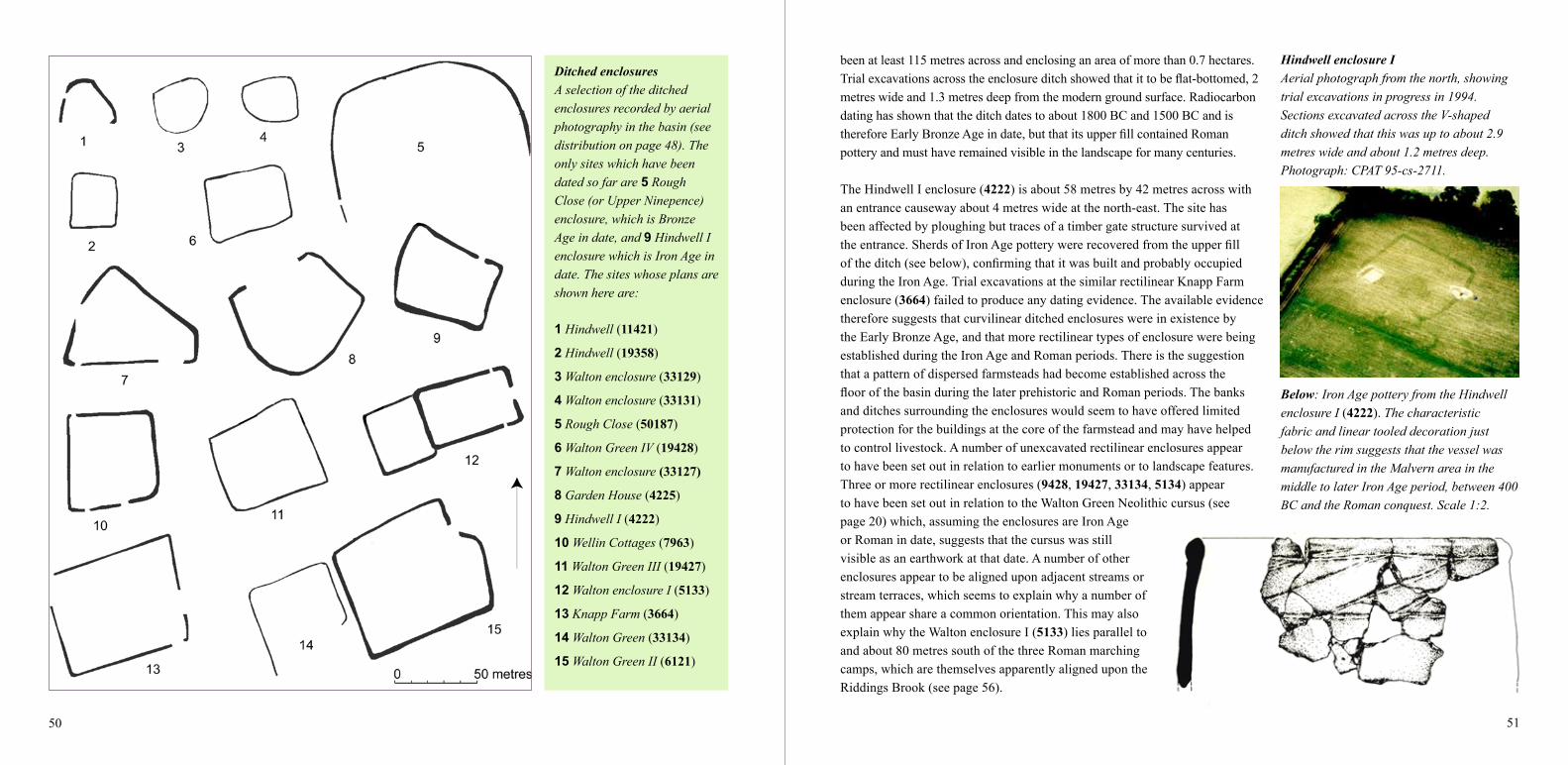
9 Hindwell I (4222)
10 Wellin Cottages (7963)
11 Walton Green III (19427)
12 Walton enclosure I (5133)
13 Knapp Farm (3664)
14 Walton Green (33134)
15 Walton Green II (6121)
been at least 115 metres across and enclosing an area of more than 0.7 hectares. Trialexcavationsacrosstheenclosureditchshowedthatittobeflat-bottomed,2metres wide and 1.3 metres deep from the modern ground surface. Radiocarbon dating has shown that the ditch dates to about 1800 BC and 1500 BC and is thereforeEarlyBronzeAgeindate,butthatitsupperfillcontainedRomanpottery and must have remained visible in the landscape for many centuries.
The Hindwell I enclosure (4222) is about 58 metres by 42 metres across with an entrance causeway about 4 metres wide at the north-east. The site has been affected by ploughing but traces of a timber gate structure survived at theentrance.SherdsofIronAgepotterywererecoveredfromtheupperfilloftheditch(seebelow),confirmingthatitwasbuiltandprobablyoccupiedduring the Iron Age. Trial excavations at the similar rectilinear Knapp Farm enclosure (3664) failed to produce any dating evidence. The available evidence therefore suggests that curvilinear ditched enclosures were in existence by the Early Bronze Age, and that more rectilinear types of enclosure were being established during the Iron Age and Roman periods. There is the suggestion that a pattern of dispersed farmsteads had become established across the floorofthebasinduringthelaterprehistoricandRomanperiods.Thebanksand ditches surrounding the enclosures would seem to have offered limited protection for the buildings at the core of the farmstead and may have helped to control livestock. A number of unexcavated rectilinear enclosures appear to have been set out in relation to earlier monuments or to landscape features. Three or more rectilinear enclosures (9428, 19427, 33134, 5134) appear to have been set out in relation to the Walton Green Neolithic cursus (see page 20) which, assuming the enclosures are Iron Age or Roman in date, suggests that the cursus was still visible as an earthwork at that date. A number of other enclosures appear to be aligned upon adjacent streams or stream terraces, which seems to explain why a number of them appear share a common orientation. This may also explain why the Walton enclosure I (5133) lies parallel to and about 80 metres south of the three Roman marching camps, which are themselves apparently aligned upon the Riddings Brook (see page 56).
Below: Iron Age pottery from the Hindwell enclosure I (4222). The characteristic fabric and linear tooled decoration just below the rim suggests that the vessel was manufactured in the Malvern area in the middle to later Iron Age period, between 400 BC and the Roman conquest. Scale 1:2.
Hindwell enclosure IAerial photograph from the north, showing trial excavations in progress in 1994. Sections excavated across the V-shaped ditch showed that this was up to about 2.9 metres wide and about 1.2 metres deep. Photograph: CPAT 95-cs-2711.

52 53
Burfa Bank hillfortBurfa Bank Iron Age hillfort, viewed here from the east in 1999, crowns one of the prominent pair of hills on the eastern side of the valley and has the appearance of controlling the entrance to the Walton basin through which the Hindwell Brook runs. The hill rises abruptly by over 200 metres from the floor of the valley and its summit is enclosed by one and in places two ramparts up to 3.5 metres high which, together with an outer ditch about a metre deep, encircle the hilltop. The entrance towards the north-west and an outwork at the west end are protected by additional banks and ditches, and were probably approached by a track running from the valley via the direction of Burfa Farm. The defences cover an area up to about 690 metres by 240 metres across and enclose an area of just under 6 hectares. The hillfort is unexcavated but the interior is likely to preserve the remains of Iron Age stone and timber houses and other structures. The hillfort is surrounded by a conifer plantation and although the interior was once planted with trees this is now, for the sake of archaeological conservation, preserved as an open space by the Forestry Commission. Without due care, tree planting and tree felling operations can cause serious damage to archaeological sites. Photograph: © Crown copyright, RCAHMW, 99-cs-0979.
Castle Ring hillfortCastle Ring hillfort (297), viewed here from the south-east in 1999, is sited on the a slight spur on the eastern side of the basin about a kilometre to the north of Evenjobb. The outer limits of the defences, marked by a single bank and ditch, are up to about 170 metres by 140 metres across and enclose an area of just under a hectare, with entrances on the north-west and south-east. The interior of the hillfort was once planted as part of Castlering Wood but is now maintained as pasture. Photograph: © Crown copyright, RCAHMW, 99-cs-1675.
Little is yet known about the nature of the farming economy within the Walton basin during the Iron Age though it is probable that the ditched enclosures became the focus of individual farms engaged in both arable cultivation and animal husbandry. Trial excavations at the Hindwell I (4222) enclosure produced charred plant remains from the ditches which included grass rhizomes and stems, brambles, and blackthorn, alder, gorse and willow or poplar and birch, with no evidence of cereal cultivation. An Iron Age pit found by chance inside the Womaston causewayed enclosure (53996), dating to the period between the 8th to 4th century BC, did produce cereal grains, however, together with weed seeds.
The relationship of the lowland enclosures to the two hillforts on the eastern side of the basin is uncertain. The hillforts, Burfa Bank hillfort (312) and Castle Ring hillfort (297) are of Iron Age date, between about 700 BC and the Roman conquest in the mid AD 50s, but may have also have been the scene of activity at earlier and later dates. Both hillforts occupy prominent hilltop positions on eastern side of the basin and may have acted as tribal centres. Burfa Bank hillfort encloses an area of about 6 hectares and Castle Ring hillfort and area of just under a hectare. The Walton basin lay on the periphery of three historically-attested Iron Age tribes, the Ordovices of mid Wales, the Dobunni of the south-west Midlands, and the Silures of south Wales, though whose territory the basin fell within is unknown.
Is it likely that lowland enclosures of the kind represented at Hindwell I continued in occupation and became the focus of estates during the Roman period. A Roman ditch probably forming part of a settlement site, with pottery of the late 3rd to 4th century AD and a quern fragment, was found during the excavation of trial trenches across the line of the northern ditch of the Neolithic Hindwell cursus near Four Stones in 2010 (see page 58). Charred plant remains from the ditch included cereal grains and waste material suggesting that crops of barley, rye and wheat were processed in the vicinity. Charred plant remains from a Roman hearth (or possibly the base of a corn-drying kiln?) dug into the Upper Ninepence round barrow (305) excavated in 1994 (pages 38 and 58) indicate that wheat, barley and oats were probably being cultivated in the basin in the period between about the 3rd and 5th centuries AD.
Above: Simplified plans of the banks and ditches of the two hillforts overlooking the eastern side of the basin. Both sites probably represent tribal centres built and occupied at some period during the Iron Age, though whether they were occupied simultaneously, permanently and still in use at the time of the Roman conquest is uncertain.

54 55
Roman military sites in the Walton basinHindwell I seems to be orientated towards the spring at Hindwell Pool about 400 metres to the east. The Walton camps are aligned upon the Riddings Brook about 150 metres to the south rather than the seasonal Summergil Brook. Both of these factors tend to suggest that the camps were built during the drier summer months when the Summergil Brook, the principal stream through the valley, often dries up. The Harpton signal station or fortlet lies just over 2 kilometres west of the Hindwell fort but does not occupy an obviously strategic position. Campaign forts were normally within a days march of each other, which suggests a launch-pad for these military operations in the area of Mortimers Cross, Herefordshire, about 14 miles to the east.
Hindwell camps I and IILeft: The plans of Hindwell marching camps I and II are plotted from aerial photographs and geophysical survey. Hindwell I (313) is up to about 480 by 370 metres across. In places there are traces of a fainter inner line, about 4 metres inside the outer ditch, which may indicate the position of a palisade. The camp encloses an area of about 17.6 hectares and would have been capable of holding a fighting force of up to as many as 10,000 men including their equipment. Only part of the plan of Hindwell II (122794) is known but it was evidently much smaller. It was more than 280 metres by 200 metres across but on topographical grounds is unlikely to have covered more than 3–5 hectares. It is more closely aligned on the Hindwell fort and may conceivably have been a construction camp. Hindwell I is assumed to be overlain by the course of the Roman road running westwards from the Hindwell Roman fort.
Roman marching camps and signal stationThe Roman military sites in the basin represent a brief but spectacular episode during the conquest of Wales, between the mid AD 50s and the late AD 70s, involving tens of thousands of soldiers. The complex of Roman marching camps at Hindwell and Walton is unique in Wales, which emphasizes the strategic importance of the valley as a routeway into central Walesinantiquity.AtleastfiveRomanmarchingcampsandasmallfortletorsignalstationare known from a combination of aerial photograph and geophysical survey. The camps were used for temporary, overnight accommodation by units of the Roman army during the early conquest period. The outer ditches have a distinctive rectangular plan with rounded corners. They would have had an internal palisade made of stakes and normally gates towards the middle of each side. Since the Roman army lived off the land when on manoeuvres, the siting ofcampsinthebasinprobablyalsoreflectsthesizeofthenativepopulationwhichfarmedthisfertile valley during the conquest period. The size of the camps was in proportion to the units they accommodated, which probably ranged from 1,000 to as many as 10,000 troops, though they are unlikely all to have been occupied at the same time.

56 57
Walton Roman camps I–IIIWalton I is about 171 metres by 145 metres across and encloses about 2.5 hectares. Walton II is about 192 metres by 163 metres across and encloses about 3 hectares. Walton III is about 168 metres by 168 metres across and encloses about 2 hectares and has a possible annex to the south, recently identified from aerial photography. Each of the camps would each have been capable of housing between about 1000 and 2000 troops on campaign. It has been suggested that the marching camps were probably built in succession, in one or more seasons, rather than being occupied simultaneously.
The Hindwell and Walton Roman marching camps all overlie earlier Neolithic monuments. Hindwell camp I overlies the Hindwell Neolithic cursus and both Hindwell camps I and II overlie the Hindwell palisaded enclosure. Walton camps II and III overlie the Walton Neolithic palisaded enclosure and camps I and II overlie the Walton Court Farm Neolithic ring-ditch. Similar relationships between Neolithic palisaded enclosures and Roman forts or marching camps has been noted elsewhere. It is intriguing to speculate what the common factors were that made these places equally attractive to Neolithic tribesmen and Roman agrimensores (military surveyors) so many thousands of years apart. In the case of the Roman camps at least, it is known from the writings of Roman military strategists such as Hyginus and Vegetius that an ideal siting would be one set on level ground, on land not liable tofloodingoroverlookedbyhigherground,withgoodlinesofsightallaround,withariverorspringtoonesideforwater,andinplaceswherethereweresufficientsuppliesoffuelandfodder for animals. Were there similar considerations during the Neolithic period?
Harpton signal stationThis intriguing site (34055) lies about mid-way between New Radnor and Walton and was first discovered from the air in 1996 when this photograph was taken by CPAT. The form of the site, which has two close-set ditches enclosing an area about 10 metres across, resembles a number of other small Roman military signal stations or fortlets in Wales. Photograph: CPAT 96-c-0015.
Walton marching campsTwo of the Walton Roman marching camps are visible in this aerial view taken in 1986. In the foreground, half of camp III is visible where it is overlain by the road to Evenjobb, just to the right of the Crown Inn. Camp II is also visible, overlain by the road to New Radnor beyond, showing as a dark cropmark to the right of the road and as a pale cropmark in the corn field to the left of the road. Photograph: CPAT 86-c-0107.

58 59
Roman fort, roads and findsThe course of the Roman roads entering the Hindwell fort are known from aerial and geophysical survey, which show that the roads were up to about 8 metres wide with flanking ditches. Further afield, the roads to the east and west are likely to be followed for much of the way by modern lanes and roads. The line of the Roman roads to the north and south are less certain. Roman activity is also indicated by chance finds such as pottery and coins (shown as yellow dots), some of which are likely to post-date the abandonment of the fort, as in the case of Roman farming activity found during excavations near 1 Four Stones and at 2 Upper Ninepence (305) (see page 53). A hearth of late Iron Age or Roman date is known at 3 Hindwell Ash (307).
Roman fort and civil settlementHindwell Roman fortHindwell Roman fort (315)wasfirstdiscoveredfromtheairin1973,immediatelytotheeast of Hindwell Farm, though fragments of pottery found here in the 1950s and 1960s had already indicated Roman activity. The fort forms part of a complex of Roman military sites in the basin, including the marching camps considered in the previous section. As noted above, the fort partly overlies the two Hindwell Neolithic palisaded enclosures. The defences of the Roman fort are represented by low earthworks to the north, east and south, enclosing an area about 150 metres across and 2.3 hectares in extent. A fort of this size is likely to have been built to accommodate an infantry or cavalry unit of up to 500 soldiers. Unlike the Roman marching camps considered in the previous section, the Hindwell Roman fort remained in occupation for some period of time. Little excavation has been undertaken inside the fort but associated potteryandcoinssuggestthatitwasfirstoccupiedduringinitialRomancampaignsinWalesduring the mid AD 50s and remained in occupation until at least the AD 80s, though the date whenitwasfinallydecommissionedisuncertain.
Hindwell Roman fortSchematic plan of the fort and annexes derived from aerial and geophysical survey, shown in relationship to the Hindwell Neolithic palisaded enclosures, streams and palaeochannels. Some details of the internal layout of the fort was revealed by geophysical survey of part of the interior in 1998. This revealed traces of internal timber buildings including the principia, the military headquarters, a building about 40 metres across with a central courtyard which, as usual, was sited towards the middle of the fort. The fort was defended by a turf rampart with timber gatehouses, surrounded by three defensive ditches up to 5 metres wide and 2.6 metres deep. The possible bath-house to the south of the fort is suggested by finds of Roman brick and hypocaust tiles and more recent geophysical survey. The extent of the vicus or civil settlement in the east annex is defined by geophysical survey and trial excavation.

60 61
Finds from excavations at the Hindwell Roman fort Head of a Roman iron bolt which would have been attached to a wooden shaft and fired from a type of catapult known as a ballista (scale 1:3), with fragments of Samian bowl decorated with hares and bushes dating to the mid AD 50s (scale 1:2 ). The bowl is stamped with the name of the potter Passienus whose workshop is known to have been near the modern town of Millau in southern France.
The fort lies towards the eastern side of the basin just over 2 kilometres due west of the Burfa Camp Iron Age hillfort and was strategically sited to control the eastern entrance to the valley, as well as to secure the vital water supply provided by Hindwell Pool which lies immediately to the south-east of the fort.Suchwasthesignificanceofthewatersupplythatitislikely that the south annex enclosed the spring as well as the military bath-house fed by water from the pool, the line of the annex ditch perhaps giving an indication of the size of the natural pool before it was dammed. An east annex enclosed a civilian settlement or vicus (see page 61). The course of the HindwellBrookhasbeencanalized,butwhetherthiswasfirstcarried out in the Roman period or subsequently is uncertain.
The fort lay at the hub of a Roman road network whose side ditches or road metalling has been traced from aerial photography and geophysical survey for up to about a kilometre to the west and for shorter distances to the north, south and east. The angled alignment of the eastern road as it approaches the fort suggests that it may have been a branch road from the main road which passed to the north of the fort, though alternatively the course chosen for the road may have
Above: Hindwell Farm and Hindwell Pool viewed from the east in 1996. The Roman fort lay in the field just to the near side of the farm. Photograph: CPAT 96-c-0097.
Above: Trial excavations in 2012 across the innermost of the three ditches enclosing the Roman civil settlement on the eastern side of the Hindwell Roman fort. Photograph: CPAT 3343-0048.
been designed to avoid more boggy ground further east. Lines of communication to the north are less certain, but the fort lay within a day’s march of forts in other directions, normally reckoned to have been between 12 and 15 Roman miles (a distance of about 20 kilometres). Itliesabout19kilometresasthecrowfliesfromthefortat Leintwardine, Herefordshire, to the north-east, about 18 kilometres from the fort at Clyro (430) to the south, and respectively about 17 kilometres and 20 kilometres from the forts at Colwyn Castle (50273) and Castell Collen (1159) to the west.
Roman civil settlement at HindwellEvidence for a civil settlement or military vicus (80117) attached to the Hindwell Roman fort is known from aerial photography, from geophysical surveys carried out by CPAT in 1998 and 2011, and from trial excavations in 2012. The vicus, enclosed by three or more defensive banks and ditches attached to the east side of the fort, had rows of perhaps up to 30 to 50 timber buildings lining the road leading out of the east gate of the fort. Trial excavations across the innermost defensive ditch in 2012 showed that this was about 2.7 metres across and over a metre deep. This appears to be the only military vicus in Wales that is known to have been provided with defences, even though it only occupied part of the annex, which seems to emphasize its frontline status. The settlement would have housed civilian merchants, shopkeepers and craftsmen such as bakers, blacksmiths and leather-workers drawn from all parts of the Roman Empire, who supplied goods and services to the garrison housed inside thefort.Thesettlementoccupiedawelldefinedzoneupto about 50 metres across extending up to 150 metres from the fort gate and would no doubt have been under the control and supervision of the military.
Right: Roman pottery from the fill of the ditch included large fragments of a Gallo-Belgic butt-beaker that had been made either in eastern Britain or on the Continent. The distinctive form of the drinking mug confirms other evidence suggesting that the fort and civilian settlement were established during early campaigns for the conquest of Wales, in the mid AD 50s.

62 63
Offa’s Dyke and Fron Hill DykeIn the early medieval period the basin has the appearance of a no-man’s-land bounded by two massive dykes. To the west lay early Welsh kingdoms which for centuries rebutted the predatory Anglo-Saxon kingdom of Mercia whose western boundary in the 790s was defined by Offa’s Dyke (10000). The bank of the dyke, up to 10 metres across and 2.5 metres high and its ditch to the west, skirts around the hills on the eastern side of the basin, crossing the floor of the Hindwell valley just to the east of Ditchyeld Bridge. The Fron Hill Dyke (2145), which is of similar dimensions, cuts across the valley of the Summergil Brook just to the west of New Radnor. It is less clear which way it faces, thought it may have been built to define Welsh-held territory.
Dykes and early settlements
Well-preserved stretches of Offa’s Dyke survive on the low hills on the north-east side of the basin between Evenjobb, Burfa Bank and Herrock Hill in Herefordshire. The dyke was built bycommandoftheAnglo-SaxonkingOffainthe790sasameansofdefiningtheboundarybetween his kingdom of Mercia and the neighbouring early Welsh district of Rhwng Gwy a Hafren (‘Land between the Wye and Severn’).
As in other parts of the borderland, English settlement eventually spread to the west of the dyke. The earliest post-Roman settlement known in the basin is Old Radnor (16185), whose church may have been in existence from the 8th or 9th century and which may have been a clas or mother church for the region. It’s original name was Raddrenove which is of early English origin,meaning‘redridgeorbank’(theprefix‘Old’beingaddedinperhapsthe12thor13thcentury to distinguish it from New Radnor). Old Radnor, Harpton and Lower Harpton and possibly Barland are all mentioned in the Domesday Book compiled in 1086, though it appears that prior to the Norman conquest much of the land in the basin was described as ‘waste’, due to constant warring between the Welsh and English kingdoms. Other early English place-names in the basin which might pre-date or post-date the Norman conquest are Kinnerton, Womaston, Walton and Downton, each of which have theOldEnglishsuffixtun signifying a farm orsettlement.Evenjobb,firstrecordedatthebeginning of the 14th century as Emynghop, is derived from the personal name Emma and the Old English hop which can mean ‘enclosed valley’.
Many of the places with early place-names have survived as farms and it is likely that small villages at Old Radnor, Evenjobb and Kinnerton, whose archaeology is considered on the following pages, only began to emerge around early manorial centres at the intersection of important routeways in the later Middle Ages.
Below: Offa’s Dyke to the east of Evenjobb, looking towards Burfa Farm and Herrock Hill, the prominent hill towards the left. The dyke heads southwards and crosses the lower ground to either side of the Hindwell Brook where it has been levelled by ploughing and now shows up as a cropmark. Like other earthwork monuments in the basin, parts of the dyke are suffering from burrowing animals such as badgers. Photograph: CPAT 1133-14.

64 65
Old RadnorAerial view of Old Radnor from the south in 2004 with the medieval church (20111) dedicated to St Stephen in the large curvilinear churchyard (16297) towards the centre. The font inside the church, carved from an erratic boulder, is taken to confirm documentary evidence suggesting that the church was founded in the early medieval period. The Domesday Book of 1086 states that there was land here for 30 ploughs, held by William, the Norman king, and that before the conquest it had been held by Harold Godwinson, the last Anglo-Saxon king of England, Photograph: CPAT 04-c-0177. Bottom left: Part of a plan of earthworks (5296) on the eastern side of Old Radnor surveyed by CPAT in 1992. The earthworks, which represent medieval house platforms, relict field boundaries and trackways, lie in the field to the top right of the aerial photograph above.
KinnertonThe village of Kinnerton viewed from the north-west in 2004 with the Kinnerton Court motte (1071) visible towards the centre (see also page 71). The place-name is first recorded in 1304 as Kynardton meaning ‘Cyneheards’ farm or settlement’. The modern village has grown up around the medieval manorial centre focused on the motte. Traces of medieval open field systems survive to the north and south of the village centre and include some surviving traces of ridge and furrow cultivation. Photograph: CPAT 04-c-0197.
EvenjobbThe village viewed from the north in 2004. One of the two medieval mottes in the village lies close to the road junction near the centre of the picture (see also page 71). The long strip fields to the left-hand side probably represent enclosed medieval open fields. The place-name is first recorded in 1304. The earliest surviving buildings are in origin 16th-century timber-framed structures such as Court Cottages (20643), Court Farm (16064), possibly on the site of a previously unrecognized moated site, and Lower House (20646). Photograph: CPAT 04-c-0194.

66 67
Plan of the medieval town of New Radnor The plan shows the extent of the medieval town in relation to traces of ridge and furrow cultivation and modern housing, surveyed by CPAT in 1991. At one time the castle had a stone keep and a stone curtain wall. The town was about 500 metres by 250 metres across and covered an area of about 10.5 hectares. Its defences consisted of a ditch and bank perhaps originally with a timber palisade, with four gates. The defences have become eroded but in places the ditch is visible as a hollow up to a metre deep and the bank still stands to a height of just under 3 metres. By the early 14th century the town held weekly markets and judging from the number of recorded burgesses would have had a population of between about 650–850. Corn-drying kilns are known at A and B.
New Radnor viewed from the south in 1988. The town is one of the finest surviving Welsh medieval towns. The medieval castle and outer bailey (1075) are visible in the background. In the middle distance the town defences (50634) can be seen to enclosure the present-day settlement whose layout reflects the medieval street pattern. The church, on the site of its medieval predecessor (20112) lies to the left of the castle. The modern road in the foreground cuts across the Summergil Brook. Photograph: © Crown Copyright, RCAHMW, 88-cs-127.
Medieval castle, walled town and market
The medieval town of New Radnor (16181) lies on the western side of the basin on the north side of the Summergil Brook. The castle is sited on a natural spur projecting into the valley fromthesouthernslopesofRadnorForestoverlookingthetownwhichislaidoutonflattergroundonthefloorofthevalley.Liketheothersmallernucleatedmedievalsettlementsinthebasin the town was sited to take advantage of a regular water supply. It lies at the point where inmostsummerstheSummergildisappearsintothegravelofthefloorofthebasinbeforere-emerging as the Hindwell Brook at Hindwell Pool towards the eastern side of the basin, about 4 kilometres to the east.
The earliest castle was probably established by the Marcher lord, Philip de Breos (Braose), in about the last decade of the 11th century to control the routeway into central Wales via
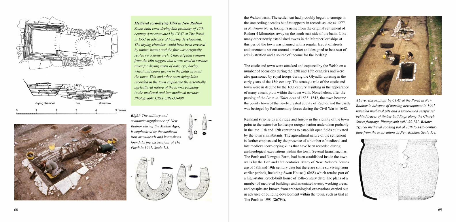
68 69
Medieval corn-drying kilns in New RadnorStone-built corn-drying kiln probably of 15th-century date excavated by CPAT at The Porth in 1991 in advance of housing development. The drying chamber would have been covered by timber beams and the flue was originally sealed by a stone arch. Charred plant remains from the kiln suggest that it was used at various times for drying crops of oats, rye, barley, wheat and beans grown in the fields around the town. This and other corn-dying kilns recorded in the town emphasize the essentially agricultural nature of the town’s economy in the medieval and late medieval periods. Photograph: CPAT cs91-33-489.
Right: The military and economic significance of New Radnor during the Middle Ages, is emphasized by the medieval iron arrowheads and horseshoes found during excavations at The Porth in 1991. Scale 1:3.
the Walton basin. The settlement had probably begun to emerge in thesucceedingdecadesbutfirstappearsinrecordsaslateas1277as Radenore Nova, taking its name from the original settlement of Radnor 4 kilometres away on the south-east side of the basin. Like many other newly established towns in the Marcher lordships at this period the town was planned with a regular layout of streets and tenements set out around a market and designed to be a seat of administration and a source of income for the lordship.
The castle and town were attacked and captured by the Welsh on a number of occasions during the 12th and 13th centuries and were alsogarrisonedbyroyaltroopsduringtheGlyndŵruprisingintheearly years of the 15th century. The strategic role of the castle and town were in decline by the 16th century resulting in the appearance of many vacant plots within the town walls. Nonetheless, after the passing of the Laws in Wales Acts of 1535–1542, the town became the county town of the newly created county of Radnor and the castle was besieged by Parliamentary forces during the Civil War in 1642.
Remnantstripfieldsandridgeandfurrowinthevicinityofthetownpoint to the extensive landscape reorganization undertaken probably inthelate11thand12thcenturiestoestablishopenfieldscultivatedby the town’s inhabitants. The agricultural nature of the settlement is further emphasized by the presence of a number of medieval and late medieval corn-drying kilns that have been recorded during archaeological excavations within the town. Several farms, such as The Porth and Newgate Farm, had been established inside the town walls by the 17th and 18th centuries. Many of New Radnor’s houses are of 18th and 19th-century date but there are some surviving from earlier periods, including Swan House (16068) which retains part of a high-status, cruck-built house of 15th-century date. The plans of a number of medieval buildings and associated ovens, working areas, and cesspits are known from archaeological excavations carried out in advance of building development within the town, such as that at The Porth in 1991 (26794).
Above: Excavations by CPAT at the Porth in New Radnor in advance of housing development in 1991 revealed medieval pits and a stone-lined cesspit set behind traces of timber buildings along the Church Street frontage. Photograph cs91-33-131. Below: Typical medieval cooking pot of 13th to 14th-century date from the excavations in New Radnor. Scale 1:4.

70 71
Mottes, manors and moats in the basinThe known and possible earthwork castles in the basin (red dots) together with the castle and walled medieval town at New Radnor and moated sites and possible moated sites at Old Radnor and Evenjobb (yellow dots). As noted above (page 45) it seems likely that the mound at Knapp Farm is a large Late Neolithic or Bronze Age round barrow rather then a motte. The mottes are shown here in relation to blocks of fields whose shapes suggest that they are former medieval open fields or furlongs belonging to either the town of New Radnor or to the early manorial centres denoted by the mottes. Some of these blocks of fields are associated with traces of ridge and furrow cultivation that may be of medieval date.
Mottes, manors and moats
Up to nine medieval earthwork castles are known around the periphery of the basin, represented by isolated mottes (castle mounds) or motte and bailey castles. Each of the castles was associated with a manorial centre within the Radnor lordship, the concentration of mottes within the basin having the appearance of a castellaria – a defended territory attached to the lordship castle at New Radnor. The castles were built between the 11th to late 13th centuries, after which thiskindoffortificationgenerallyceasedtobeconstructed.
Many of the mottes are associated with farming settlements that have continued in existence to the present day. Those at Kinnerton, Evejobb and possibly Old Radnor lie in small villages, whilst those at Barland and Womaston are associated with single farms, and there is evidence to suggest that the motte at Burfa, which though now isolated, may still have remained the focus ofhabitationintoperhapsthepost-medievalperiod.Thesteep-sidedandflat-toppedmotteswere originally surrounded by a ditch from which the mounds were built. Next to the motte, at least in some instances, was one or more defended enclosures or baileys. Timber or possibly stone towers were built on the top of the mottes, and domestic buildings were erected in the bailey. Most of the earthwork castles in the basin are reasonably well preserved, though further fieldworkatsomeofthesitesisneededtoclarifytheiroriginalformandextent.
The village of Evenjobb has two mottes. On the eastern edge of the village is the small Dunn’s Lane motte (301) which has no certain bailey. This is 2.8 metres high and 20 metres in diameter at the base with a top 10 metres in diameter, encircled by a ditch 3 to 4 metres across. A second motte near the centre of the village (302) is of similar size but has been partly quarried away on one side. Its bailey may have lain to the north in an area now below a bungalow and its garden. It has been suggested there may have been a shell keep around the motte. Evancoyd has a small motte (298) which is about 20 metres in diameter, surviving to a height of 2.2 metres. The small, flat-toppedandgrass-coveredKinnertonCourtmotte(1071) is only just over 2 metres high and about 12 metres in diameter, with a ditch around the west and south but again there are no traces of a bailey. The setting of the motte is unusual since it lies in a waterlogged location overlooked by higher ground to the north-west, though it dominates lower ground to the south. The tree-covered motte in the grounds of Womaston House (317) is much larger than those at Evenjobb and Kinnerton, being about 4.5 metres high and 15 metres in diameter at the summit and is surroundedbyawater-filledmoat.Aseriesofoutworksthatarelikelytobecontemporarywith
Below: Sketch of field boundaries at Kinnerton which appear to derive from medieval open fields, with recorded traces of ridge and furrow cultivation shaded, shown in relation to Kinnerton Court motte.

72 73
Burfa Bog motteBurfa Bog medieval motte (311) in the nature reserve on the eastern side of the basin is owned and managed by the Radnorshire Wildlife Trust. The motte is one of the most readily accessible of the many well-preserved earthwork castles that survive within the basin. Photograph: CPAT 3608-0012.
Left: Earthwork survey of the Burfa Bog medi-eval motte undertaken by CPAT in 1992. The building (1788) whose foundations lie next to the road on the right was still inhabited at the time of the Tithe survey in the 1840s.
Below: Earthwork survey of Castle Nimble (360) just to the north-west of Old Radnor made by CPAT in 1992.
the castle mound and may represent one or more baileys, but like a number of other mottes in theWaltonbasinitsinterpretationwouldbenefitfromdetailedgroundsurvey.BoththeBarlandmotte (304) and the motte in the Burfa Bog nature reserve (311) are equally impressive. The Barland motte overlooks a steep-sided valley to the south-east and is about 5 metres high, with a bailey to the north enclosed by a bank about 1.5 metres high. The Burfa motte is up to about 4 metres high, 40 metres across at the base and with a D-shaped summit 20 metres by 15 metres across, with indications of an encircling ditch. Visible to the north and east are the footings of two former rectangular buildings which as noted above may indicate continued occupation of the site in the late medieval and post-medieval periods, following the abandonment of the motte. The earthworks at Castle Nimble (360)lieonthefloorofthevalleyjusttothenorth-westofthe village of Old Radnor. Questions have been raised about what the site represents though superficiallythereisevidencefor a low motte, about 1.5 metres high and 25 metres in diameter to the west, with a small bailey to the east surrounded by a bank and ditch. Like a number of the other sites in the basin, its true nature can probably only be resolved by further study.
Traces of a moated medieval parsonage, possibly of 13th to 14th century date, with ditches over 2 metres deep, are visible just to the south of the church at Old Radnor (374). A second moated site has recently been tentatively identifiedfromtheangularpond associated with the late medieval timber-framed farmhouse at Court Farm at Evenjobb (16064).

74 75
Fields, farms and land use given in the Tithe surveyThe earliest consistent picture of agriculture in the basin is provided by the Tithe surveys of the parishes of New Radnor and Old Radnor in the 1840s. These show that most farms had a mixed economy, based on arable cultivation and dairying and cattle and sheep husbandry. At this period almost half of the floor of the basin was under pasture and about a third was cultivated, probably largely for grain but with some root crops for animal fodder. The farms were about 60 hectares in extent on average. They were spaced about a kilometre apart and were mostly tenanted, belonging to a number of the larger Radnorshire and Hereforshire estates that had emerged during the 17th and 18th centuries. The farms shown here are 1 Knowle Farm, 2 Bache Farm, 3 Badland Farm, 4 Kinnerton Farm, 5 Bestbrook Farm, 6 Lea Farm, 7 Downton Farm, 8 Harpton Court, 9 Harpton, 10 Knapp Farm, 11 Four Stones, 12 Hymns Farm, 13 Rough Close, 14 Evenjobb Farm, 15 Barland Farm, 16 Burfa Farm, 17 Womaston, 18 Hindwell, 19 Walton Farm, 20 Lower Harpton. Recorded ridge and furrow and water meadows are also shown.
Later fields and farms
As noted in an earlier section, a number of feudal manors associated with mottes are likely to have been in existence by the 11th to 13th century around the margins of the basin, in addition to medieval farms within the town of New Radnor, most of which were associated with blocks offieldswhoseshapessuggestthattheyareformermedievalopenfields(seepage70).Manorsare also known to have existed at the time of the Norman conquest at Harpton and Lower Harpton where no earthwork castles are known. Other farms, such as Downton Farm (32047), were in existence by the 13th century (see page 76), and at both Burfa Farm (32098) and Lower House, Walton (16067) there are surviving fragments of cruck-built timber halls which show that these were in existence by the 15th-century. The surrounding mountain land probably remained largely unenclosed until the 18th and 19th centuries. It seems likely that land towards the middle of the basin and along the principal streams had survived as unenclosed lowland commons until perhaps the 16th and 17th centuries, when farms such as Hindwell Farm (32135) were created as part of the enclosure movement – earlier lowland commons being suggested by place-names such as Walton Green. The 16th and 17th centuries were probably also the periodwhenmedievalopenfieldswerebeingenclosedandwhichalsosawtheemergenceofthe larger landed estates. Traces of ridge and furrow cultivation have been recorded near New Radnor, Old Radnor, Kinnerton, Evenjobb and Downton (see opposite), some but probably not allofwhichrepresentformermedievalopenfieldcultivation.Agriculturalimprovementswereintroduced by landowners and tenants in the basin during the 18th and 19th centuries, including the introduction of root crops like turnips into the rotation system. Soil fertility was also being improved by the application of lime from stone quarries and limekilns at Dolyhir (125681, 125682) just a kilometre or so to the south of Old Radnor. Water meadows were built at Kinnerton (19349), Rough Close (122808) and Hindwell (123537) to help maintain grassland prone to summer drought. A number of prominent local landowners, such as Edward Lewis of Downton and Thomas Lewis of Harpton were instrumental in establishing the Radnorshire turnpike trusts in the late 18th and 19th centuries, which greatly improved road transport and enhanced opportunities for marketing agricultural produce.
Below: Aerial view of the basin in 2004, looking westwards towards New Radnor and the steep-sided valley of the Summergil Brook to the west of New Radnor in the distance. Photograph: CPAT 04-c-0195.

76 77
A medieval miracle at DowntonAt about 9 o’clock on the morning of 18 September 1305, Thomas, aged 14, was crossing the Summergill Brook to gather wild apples when he noticed a bundle of red clothes in the water. At first he thought that they had been left there by a washerwoman but soon realized that he had found the body of William de Lorimer, aged two-and-a-half, from Downton Farm, which lay ‘the distance of an arrow's flight’ from the stream. He took the boy out of the water and shouted for help. The occupants of the farm came running out, and were soon praying to Thomas Cantilupe, the bishop of Hereford who had died 22 years earlier, and in whose diocese the farm lay. William’s apparently lifeless body was taken into the farmhouse where, during the afternoon he miraculously recovered, though he is said to have remained ‘a strange colour’ for some time. The story is documented in the Vatican archives in support of the canonization of Saint Thomas of Hereford in 1320.
DowntonDownton, viewed here here from the north-west in 2004, lies about 1.5 kilometres to the east of New Radnor. It is one of the farms that originated as a manorial centre within the basin by the Middle Ages, but in this instance without any sign that it had a defensive motte. The surviving farmhouse (32047) towards the top possibly dates from the 17th century, replacing an earlier house. The outbuildings, of timber, stone and brick, date from the 17th to 19th centuries and include a cowhouse, threshing barn, stables and open-fronted cow-sheds (40294) as well as modern farm buildings. Downton House (32045), the large house to the right, dates from the 18th and mid 19th centuries. Towards the centre of the photograph are fishponds (55224), presumably of medieval or post-medieval date, fed by the Summergil Brook whose meandering course lies to the left of the farm. Photograph: CPAT 04-c-0186.
Harpton CourtHarpton, viewed from the north in 2004, was the former seat of the Lewis family from the 16th century, one of whose sons in the 19th century was Sir George Cornewall Lewis, Chancellor of the Exchequer under Palmerston. The surviving late 19th-century north-west wing and stable yard are visible towards the centre and directly overlie the projected line of the Neolithic Hindwell cursus, which runs diagonally from the top right corner to bottom left of the picture. To the right of the house is the 19th-century walled garden. Photograph: CPAT 04-c-182.
Hindwell FarmThis is one of the modern productive farms on the floor of the basin, seen here from the east, with the peak of the Whimble, on the eastern edge of Radnor Forest in the background. The farm, which overlies part of Hindwell Neolithic palisaded enclosure and Hindwell Roman fort, dates from at least the 16th century. The present farmhouse (32135) dates to the late 17th and early 18th centuries and has associations with the poet William Wordsworth and his sister Dorothy who visited relatives here between 1810 and 1812.

78 79
Modern farming in the basinToday, about 58% of the productive land close to the floor of the basin is pasture, about 35% arable and 7% woodland. Mixed arable and livestock farming remains the norm but compared with the mid 19th century there has been an increasing focus on the cultivation of the central part of the basin for cereals, root crops and potatoes, together with the introduction of larger steel-framed agricultural buildings and some intensive poultry units.
Traditional ploughing gradually erodes upstanding monuments while potential increases in the depth of cultivation can plane off buried features and deposits. The deeper cultivation and ridging needed for the cultivation of root crops can also have the same effect. Conservation tillage techniques (such as minimum, non-inversion tillage and direct drilling) have been introduced by some of the farms in the basin in recent years in order to reduce fuel consumption and soil erosion. These can reduce the impact upon buried archaeological deposits in the short term but may require periodic deeper ploughing or subsoiling to prevent soil compaction, which can be damaging. Top left and middle: Typical agricultural scenes in the basin in 2011 and 2008. Photographs: CPAT 3608-0090, 2627-0068. Bottom left: modern land use in 2009 plotted from aerial photography. This gives a generalized picture of land use but makes no distinction between native woodland and conifer plantations, between arable and fallow, or between permanent pasture and pasture within a rotation.
Archaeology and conservation
The Walton basin has a remarkable archaeological sequence that touches upon Late Upper Palaeolithic and Mesolithic early hunter-gatherers, Neolithic and Bronze Age tribesmen, Iron Age farmers and chieftains, Roman generals and merchants, early Anglo-Saxon settlers, and Norman marcher lords. The emergence of modern farms and settlements is simply the most recent episode in the basin’s history. Archaeologists have only just begun to scratch the surface and there is so much more to discover about the history of the basin. As earlier pages have shown, the evidence which still lies hidden in the ground is important not just to the immediate area but to the history of Wales and the borderlands as a whole.
One of the elements of the current study has been to look at the conservation aspects of this nationally-important complex of archaeological sites. One of the particular issues in the Walton basinisthesheersizeofmanyofthearchaeologicalsitesthatareknown.Muchofthefloorof the basin has been ploughed at least periodically over the course of many centuries and although on the surface little may appear to have changed, there is little doubt that increasing mechanization can lead to the erosion of archaeological deposits even in the case of land that is only occasionally ploughed as part of a rotation. Recent studies elsewhere in Britain have shown that the archaeological sites most at risk are those where earthworks such as banks and barrow mounds are still preserved, sites where the soil is frequently ridged up for crops such as potatoes, and sites on slopes subject to soil erosion. Other, non-agricultural threats to archaeological sites include the activities of burrowing animals, building development, and forestry. These can be equally detrimental but are often easier to control than the gradual effects of plough erosion. Potential agricultural threats to archaeological sites in the Walton basin have been touched on in earlier pages and include plough erosion of barrow mounds and buried land surfaces beneath them, plough erosion of lithic scatter sites and early settlement evidence they represent, the lowering of land surfaces around monuments, plough erosion of the interiors of ditched enclosures and plough erosion of cropmark sites on slopes or on ridges.
Below: Vintage tractors at the All-Wales Championship Ploughing Match and European Vintage Ploughing Championships held at Hindwell and Walton Court farms in September 2008, on the fiftieth anniversary of the first All Wales Ploughing Match which took place here in October 1958. The tractors in the foreground are Fergusson TE20s (‘Little Grey Fergies’) manufactured between 1946 and 1956. The Radnor Forest and the Whimble are visible on the skyline. Photograph: © Roger Whitehead.

80
Some archaeological conservation case studiesArchaeological sites in the countryside are threatened by various agencies, as illustrated by these examples. Photographs: CPAT 3335-0021, 3608-0089, 3608-21, 3608-18, all taken in 2011.
a Hindwell cursus and Hindwell palisaded enclosureThe trial trench excavated at the intersection of the Hindwell Neolithic cursus (33109) and the Hindwell Neolithic palisaded enclosure (19376) in 2011 showed that the cursus was the earlier monument. It also revealed that the topsoil here was in places less than 0.2 metres deep. This illustrates how vulnerable archaeological deposits can be to deep ploughing or ridging up for root and potato crops. Sites on slopes or on natural ridges are equally vulnerable as the subsoil surface is lowered by each successive ploughing and topsoil is carried downhill. In the photograph the postholes and ramps of the palisaded enclosure can be seen running diagonally across the trench with post-positions to the left.
b Four stones stone circleThe stones of the Four Stones stone circle (1072) are preserved, but constant ploughing around them over the centuries has the inevitable effect of leaving them on a raised ‘island’ of unploughed soil. Little is known about this kind of monument, which is rare in Wales, and it is uncertain whether there were other less visible elements of the monument and how far these may have extended beyond the stones.
c and d Knobley Brook round barrowThe Knobley Brook Bronze Age round barrow (310) illustrates two of the causes of damage to earthwork sites. The western edge of the monument (to the right of the hedge in the middle picture) lies in field that is regularly ploughed and has been considerably lowered. The eastern side, though safe from ploughing in the Burfa Bog nature reserve, is nonetheless vulnerable to burrowing animals, as shown in the bottom picture.
a
b
c
d