Walks Around Aoraki Village
2
Further information Aoraki/Moun t Cook Visitor Ce ntre Aoraki/Moun t Cook Phone: (03) 435 1186 Email: [email protected] www.doc.govt.nz Walks around Aoraki/Mount Cook village AORAKI/MOUNT COOK NATION AL PARK Published by Department of Conservation Canterbury Conservancy Private Bag 4715 Christchurch, New Zealand 2009 www.doc.govt.nz Tasman valley walks T asman Valley Road is a scenic 8-kilometre drive on an unsealed road to the Blue Lakes car park and shelter . Blue Lakes and Tasman Glacier view Time: 40 minutes return Start from the Blue Lakes shelter and meander up past the lakes to a viewpoint on the moraine wall. There are good views of the lower Tasman Glacier , icebergs and the mountains at the head of the valley. The lakes offer good swimming in summer and can be reached by making a side trip off the main track. The Blue Lakes, originally named because of their intense blue colour, could now be more accurately described as green ponds. Tasman Lake Time: 50 minutes – 1 hour return This trip branches off the T asman Glacier View Track just past the Blue Lakes shelter and leads to a viewpoint of the glacier terminal lake and the source of the Tasman River . Icebergs can be seen floating in the lake in summer, and in winter the lake freezes over. Ball Shelter Hut Route Time: 3–4 hours one way From the Blue Lakes car park, follow the line of the old Ball Hut road alongside T asman Glacier. Ball Shelter is close to the historic Ball Hut site and offers superb views of the glacier and surrounding peaks. Take care, as the moraine wall in this area and along the road is very unstable. Sign your intentions at the Visitor Centre if you wish to stay at the hut, and pay your fees before depar ting. Shelte r Hut T oilets Car park Camping area Short walk—well-formed, easy walking for up to an hour Walking track—well-formed easy walks from a few minutes to a day Tramping track—mostly unformed but has track directional markers, poles or cairns Route—unformed, suitable only for people with high-level backcountry skills and experience 4WD track Suggestions for corrections or improvements should be emailed to: [email protected] S e a l y T a r n s T r a c k P h o t o : M R o s e n Map background: Geographx
-
Upload
bobcalleydaya -
Category
Documents
-
view
222 -
download
0
Transcript of Walks Around Aoraki Village

8/17/2019 Walks Around Aoraki Village
http://slidepdf.com/reader/full/walks-around-aoraki-village 1/2
Further information
Aoraki/Mount Cook Visitor Centre
Aoraki/Mount Cook
Phone: (03) 435 1186Email: [email protected]
www.doc.govt.nz
Walks aroundAoraki/MountCook village AORAKI/MOUNT COOK NATIONAL PARK
Published by
Department of Conservation
Canterbury Conservancy
Private Bag 4715
Christchurch, New Zealand
2009
www.doc.govt.nz
Tasman valley walks
Tasman Valley Road is a scenic 8-kilometre drive on an
unsealed road to the Blue Lakes car park and shelter.
Blue Lakes and Tasman Glacier view
Time: 40 minutes return
Start from the Blue Lakes shelter and meander up past
the lakes to a viewpoint on the moraine wall. There aregood views of the lower Tasman Glacier, icebergs and the
mountains at the head of the valley. The lakes offer good
swimming in summer and can be reached by making a
side trip off the main track. The Blue Lakes, originally
named because of their intense blue colour, could now be
more accurately described as green ponds.
Tasman Lake
Time: 50 minutes – 1 hour return
This trip branches off the Tasman Glacier View Track just
past the Blue Lakes shelter and leads to a viewpoint of the
glacier terminal lake and the source of the Tasman River.
Icebergs can be seen floating in the lake in summer, and in
winter the lake freezes over.
Ball Shelter Hut Route
Time: 3–4 hours one way
From the Blue Lakes car park, follow the line of the old Ball
Hut road alongside Tasman Glacier. Ball Shelter is close
to the historic Ball Hut site and offers superb views of the
glacier and surrounding peaks. Take care, as the moraine
wall in this area and along the road is very unstable.
Sign your intentions at the Visitor Centre if you wish to stay
at the hut, and pay your fees before departing.
Shelte r Hut Toilets
Car park Camping area
Short walk—well-formed, easy walking for up to an
hour
Walking track—well-formed easy walks from a few
minutes to a day
Tramping track—mostly unformed but has track
directional markers, poles or cairns
Route—unformed, suitable only for people with
high-level backcountry skills and experience
4WD track
Suggestions for corrections orimprovements should be emailed to:[email protected]
S e a l y T a r n s T r a c k
P h o t o :
M R
o s e n
Map background: Geographx
8/17/2019 Walks Around Aoraki Village
http://slidepdf.com/reader/full/walks-around-aoraki-village 2/2
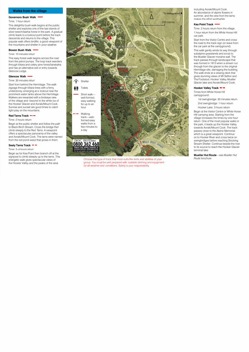
Walks from the village
Governors Bush Walk
Time: 1 hour return
This delightful bush walk begins at the public
shelter and explores one of the last stands of
silver beech/tawhai forest in the park. A gradual
climb leads to a lookout point before the track
descends and returns to the village. This
popular walk offers birdlife, a good viewpoint of
the mountains and shelter in poor weather.
Bowen Bush Walk
Time: 10 minutes return
This easy forest walk begins across the road
from the petrol pumps. The loop track wanders
through tötara and celery pine forest/tanekaha
and has an alternative exit or entry towards
Glencoe Lodge.
Glencoe Walk
Time: 30 minutes return
Start from behind the Hermitage. The walk
zigzags through tötara trees with a ferny
understorey, emerging at a lookout near the
prominent water tanks above the Hermitage.
Walkers are rewarded with a birdseye view
of the village and beyond to the white ice of
the Hooker Glacier and Aoraki/Mount Cook.
Sunrise and sunset are good times to catch
light-play on the mountains.
Red Tarns Track
Time: 2 hours return
Begin at the public shelter and follow the path
to Black Birch Stream. Cross the bridge then
climb steeply to the Red Tarns. A viewpointoffers a spectacular panorama of the valley
and Aoraki/Mount Cook. The tarns were named
from the red pond weed that grows in them.
Sealy Tarns Track
Time: 3–4 hours return
Begin as for Kea Point then branch off at the
signpost to climb steeply up to the tarns. This
energetic walk gives spectacular views of
the Hooker Valley and the peaks of the area
including Aoraki/Mount Cook.
An abundance of alpine flowers in
summer, and the view from the tarns
makes the effort worthwhile.
Kea Point Track
Time: 2 hours return from the village,
1 hour return from the White Horse Hill
car park
Start from the Visitor Centre and cross
the road to the track sign (or leave fromthe car park at the campground).
This walk gently winds its way through
subalpine grasslands and scrub to
the Mueller Glacier moraine wall. The
track passes through landscape that
was formed in 1913 when a stream cut
through from the glacier to the original
Hermitage site, damaging the building.
The walk ends at a viewing deck that
gives stunning views of Mt Sefton and
The Footstool, Hooker Valley, Mueller
Glacier lake and Aoraki/Mount Cook.
Hooker Valley Track
Times from White Horse Hill
campground:
1st swingbridge: 30 minutes return
2nd swingbridge: 1 hour return
Hooker Lake: 3 hours return
Begin at the Visitor Centre or White Horse
Hill camping area. Starting from the
village increases the times by one hour
return. One of the most popular walks in
the park, it leads up the Hooker Valley
towards Aoraki/Mount Cook. The track
passes close to the Alpine Memorial,which is a great viewpoint. Continue
on to Hooker River and cross twice on
swingbridges before reaching Stocking
Stream Shelter. Continue beside the river
to its source to reach the Hooker Glacier
terminal lake.
Mueller Hut Route—see Mueller Hut
Route brochure
Shelter
Toilets
Short walk—
well-formed,
easy walking
for up to an
hour
Walking
track—well-
formed easy
walks from a
few minutes to
a day
Choose the type of track that most suits the skills and abilities of your
group. You must be well prepared with suitable clothing and equipment
for all weather and conditions. Safety is your responsibility.
0 200 metres
N


![walk4life.info · Web viewLYONSHALL MEDIEVAL WALKS Walk No. 1. [Lyonshall Village Hall - circuitous route taking approximately one hour]. Start point: The Village “Memorial” Hall](https://static.fdocuments.in/doc/165x107/5e6525335a9331133070ecd5/web-view-lyonshall-medieval-walks-walk-no-1-lyonshall-village-hall-circuitous.jpg)