WA-271-P Exploration Drilling Program Environment Plan … · WA-271-P Exploration Drilling Program...
37
WA-271-P Exploration Drilling Program Environment Plan Summary Exploration Revision 1 March, 2015
Transcript of WA-271-P Exploration Drilling Program Environment Plan … · WA-271-P Exploration Drilling Program...

WA-271-P Exploration Drilling Program Environment Plan Summary
Exploration Revision 1
March, 2015

THIS PAGE HAS BEEN INTENTIONALLY LEFT BLANK

WA-271-P Exploration Drilling Program Environment Plan Summary
This document is protected by copyright. No part of this document may be reproduced, adapted, transmitted, or stored in any form by any process (electronic or otherwise) without the specific written consent of Woodside. All rights are reserved.
Controlled Ref No: Revision: 1 Native file DRIMS No: 10046826 Page iii of 37
Uncontrolled when printed. Refer to electronic version for most up to date information.
TABLE OF CONTENTS
1. INTRODUCTION..................................................................................................... 4
2. LOCATION OF THE ACTIVITY .............................................................................. 4
3. DESCRIPTION OF THE ACTIVITY ........................................................................ 5
3.1 Timing of the Activities ...................................................................................................... 5
4. DESCRIPTION OF THE RECEIVING ENVIRONMENT ......................................... 6
4.1 Physical............................................................................................................................. 6
4.2 Biological ........................................................................................................................... 6
4.3 Socio-Economic and Cultural .......................................................................................... 12
5. ENVIRONMENTAL IMPACTS AND RISKS ......................................................... 13
5.1 Risk Identification and Evaluation .................................................................................... 13
5.2 Planned (Routine and Non-routine) Activities .................................................................. 15
5.3 Unplanned (Accidents/Incidents) Activities ...................................................................... 16
6. ONGOING MONITORING OF ENVIRONMENTAL PERFORMANCE ................. 16
6.1 Environment Plan Revisions............................................................................................ 17
7. CONSULTATION .................................................................................................. 18
7.1 Engagement Activities ..................................................................................................... 18
7.2 Ongoing consultation....................................................................................................... 19
8. TITLEHOLDER NOMINATED LIAISON PERSON ............................................... 20
APPENDIX A: ENVIRONMENTAL IMPACTS AND RISKS .............................................. 21
APPENDIX B: SUMMARY OF RESPONSE ARRANGEMENTS FROM OIL POLLUTION EMERGENCY PLAN ............................................................................................ 27
APPENDIX C: SUMMARY OF STAKEHOLDER FEEDBACK AND WOODSIDE’S RESPONSE .......................................................................................................... 32
List of Tables
Table 2-1: Preliminary coordinates and water depth for the Petroleum Activities Program – Phase 1 within WA-271-P ............................................................................................................................. 5 Table 4-1: Summary of Established and Proposed Marine Protected Areas (MPAs) and other Sensitive Locations ......................................................................................................................... 7 Table 7.7-1: Stakeholders consulted through WA-271-P Exploration Drilling Program EP ............ 18 Table 7-2: Stakeholders notified through ongoing consultation. .................................................... 19
List of Figures
Figure 2-1: Location of Petroleum Activities Program ...................................................................... 4 Figure 4-1: Established and Proposed Commonwealth and State Marine Protected Areas in relation to the Petroleum Activities Program .................................................................................. 10 Figure 5-1: Key steps in Woodside’s Risk Management Framework ............................................. 13

WA-271-P Exploration Drilling Program Environment Plan Summary
This document is protected by copyright. No part of this document may be reproduced, adapted, transmitted, or stored in any form by any process (electronic or otherwise) without the specific written consent of Woodside. All rights are reserved.
Controlled Ref No: Revision: 1 Native file DRIMS No: 10046826 Page 4 of 37
Uncontrolled when printed. Refer to electronic version for most up to date information.
1. INTRODUCTION
Woodside Energy Ltd (Woodside), as nominated Titleholder (on behalf of a Joint Venture comprising Mitsui Exploration and Production Pty Ltd), under the Offshore Petroleum and Greenhouse Gas Storage (Environment) Regulations 2009 (referred to as the Environment Regulations), proposes to undertake drilling of up to three wells to explore for potentially commercial hydrocarbon resources within permit area WA-271-P, for the project known as the WA-271-P Exploration Drilling Program, and hereafter referred to as the Petroleum Activities Program.
The Petroleum Activities Program will be undertaken in two phases, Phase 1 will consist of the drilling of one exploration well within WA-271-P and Phase 2 may potentially involve the drilling of up to two additional exploration wells. The scope of this Environmental Plan (EP) is Phase 1 activities only. Prior to the commencement of Phase 2 activities, a revised EP will be submitted under Regulation 17(5) of the Environment Regulations and activities will not commence until the plan has been accepted under Regulation 21 of the Environment Regulations.
This EP Summary has been prepared to meet the requirements of Regulation 11(3) and 11(4) under the Environment Regulations, as administered by the National Offshore Petroleum Safety and Environmental Management Authority (NOPSEMA). This document summarises the WA-271-P Exploration Drilling Program Environment Plan, accepted by NOPSEMA under Regulation 10A of the Environment Regulations.
2. LOCATION OF THE ACTIVITY
The proposed Petroleum Activities Program (Phase 1) area is located in permit area WA-271-P, Exmouth Sub-basin, Western Australia, offshore in Commonwealth waters, approximately 65 km north-west of Exmouth (Figure 2-1). The coordinates of the proposed well, Malaguti-H, and approximate water depth are shown in Table 2-1.
Figure 2-1: Location of Petroleum Activities Program

WA-271-P Exploration Drilling Program Environment Plan Summary
This document is protected by copyright. No part of this document may be reproduced, adapted, transmitted, or stored in any form by any process (electronic or otherwise) without the specific written consent of Woodside. All rights are reserved.
Controlled Ref No: Revision: 1 Native file DRIMS No: 10046826 Page 5 of 37
Uncontrolled when printed. Refer to electronic version for most up to date information.
Table 2-1: Preliminary coordinates and water depth for the Petroleum Activities Program – Phase 1 within WA-271-P
Well Name Water Depth (~m) Latitude Longitude
GDA 94 MGA Zone 50
Malaguti-H 590 -21°39’52.546"S 113° 51’47.859" E
An Operational Area will be implemented around the well location. The Operational Area defines the spatial boundary of the Petroleum Activities Program that will be managed under the EP. For a dynamically positioned (DP) drill rig/drillship, the Operational Area encompasses a radius of 500 m from the well centre. If a moored drill rig/drillship undertakes the drilling program, the Operational Area comprises a radius of 2500 m from the well centre, to allow for the installation of moorings.
Transit to and from the Operational Area by support vessels and drill rig/drillship; and port activities associated with the support vessels, is not within the scope of the EP.
3. DESCRIPTION OF THE ACTIVITY
The exploration well will be drilled by either a semi-submersible drill rig/drillship that is moored or operates under DP, or a DP drillship, with associated support vessels.
Key activities are as follows:
Drilling of the top-hole sections using seawater with high viscosity sweeps
Installation and cementing of steel casing in the hole
Installation of the blow out preventer (BOP) on the wellhead and testing
Connection of marine riser between the BOP and the drill rig/drillship to provide a closed loop system for the recirculation of drilling fluids and drill cuttings from the well to the drill rig/drillship.
Drilling of bottom hole sections to the planned depth
Formation evaluation, may include cores, wireline logging and vertical seismic profiling (VSP) as required.
On completion plugging and abandonment of the well
Drill cuttings generated during drilling of the top hole sections will be discharged at the seabed. For the bottom hole sections, once the marine riser has been installed, drill cuttings will be returned to the drill rig and discharged at the sea surface below the water line.
The drilling fluid for the Petroleum Activities Program will be a Water Based Mud (WBM) drilling fluid system.
3.1 Timing of the Activities
The proposed Petroleum Activities Program is scheduled to commence in Q2 2015 with the Malaguti well taking approximately 60 days. The schedule and timeframe may be subject to change due to operational requirements and external influences such as drill rig/drillship availability, weather conditions and oceanic conditions. The EP has risk assessed the drilling of the oil well throughout the year (all seasons) to provide operational flexibility for the drill rig/drillship schedule changes and availability.

WA-271-P Exploration Drilling Program Environment Plan Summary
This document is protected by copyright. No part of this document may be reproduced, adapted, transmitted, or stored in any form by any process (electronic or otherwise) without the specific written consent of Woodside. All rights are reserved.
Controlled Ref No: Revision: 1 Native file DRIMS No: 10046826 Page 6 of 37
Uncontrolled when printed. Refer to electronic version for most up to date information.
4. DESCRIPTION OF THE RECEIVING ENVIRONMENT
4.1 Physical
The permit area is located within the Commonwealth waters of the North West Province (NWP) defined under the Integrated Marine and Coastal Regionalisation of Australia (IMCRA v4.0) and lies within the wider in the North West Marine Region (NWMR), approximately 65 km from Exmouth (at its closest point) and in water depths ranging from approximately 200 to 2000 m. The climate within the NWP region is dry tropical, exhibiting a hot summer season from October to April and a milder winter season between May and September.
Water circulation in the NWP and permit area is dominated by the recirculation (via the South Equatorial Current) of the Indonesian Throughflow. Surface waters moving southward consolidate along the shelf break to form the Leeuwin Current which is strongest in winter. The Leeuwin Current runs southward along the edge of the continental shelf and is primarily a surface flow (up to 150 m deep). Tides are strongly semi-diurnal and generate tidal currents along an east north-east – west south-west axis at 0.1–0.3 m/s.
The bathymetry of the NWMR is characterised by four distinct zones: the inner continental shelf (0 – 30 m), the middle continental shelf (30 – 120 m), the outer shelf/continental slope (occurs at approximately 120 m) and the abyssal plain (occurs beyond the shelf break). The Petroleum Activities Program is located within water depths of approximately 590 m on the outer shelf. At approximately 120 m, a terrace of gradients between 5 and 20 degrees at the start of the outer shelf represents a paleo-shoreline and marks an important divide between shelfal carbonate sands and cemented carbonates and the finer, less cemented slope materials offshore. Sediments of the area are consistent with the broader slope and are characterised by carbonate mud and silt. Key features include a series of offshore, deep water canyons linking the Cuvier Abyssal Plain and Cape Range Peninsulaand are listed as one of the Key Ecological Features1 (KEFs) of the NWP. The canyons are associated with upwelling as they channel deep water from the Cuvier Abyssal Plain up on the continental slope.
4.2 Biological
The offshore environment of the region contains environmental assets/receptors of high value or sensitivity, including habitats and species that are vulnerable or that provide valuable ecological services such as KEFs. Other high value environmental receptors include coastal waters and habitats such as the Ningaloo Coast and the associated resident, temporary or migratory marine fauna, including EPBC Act species such as marine mammals, turtles and birds. The marine environment of these offshore locations is pristine and many sensitive receptor locations are protected as part of Commonwealth and State managed areas including the 2012 proclaimed network of North West Marine Bioregion Commonwealth Marine Reserves (CMR).
The permit area is located within the Gascoyne Commonwealth Marine Reserve (CMR), while the Ninagloo CMR and Ningaloo Marine Park, which are both part of the Ningaloo Coast World Heritage Area (WHA), are located adjacent to the permit area (Figure 4-1). Additionally three KEFs: the Canyons linking the Cuvier Abyssal Plain and the Cape Range Peninsula, Commonwealth waters adjacent to Ningaloo Reef and Continental Slope Demersal Fish Communities, were identified in the permit area. However the location of the proposed well site does not overlap with any of these KEFs. Values and sensitivities of the established and proposed marine protected areas and other sensitive areas in the wider regional setting (potentially affected by the loss of oil) are listed in Table 4-1. No Ramsar sites were identified that would be affected by the Petroleum Activities Program (planned and unplanned).
1 Key Ecological Features are defined as components of the Commonwealth marine environment that, based on current scientific
understanding, are considered to be of regional importance from a biodiversity and/or ecosystem function and integrity value.

WA-271-P Exploration Drilling Program Environment Plan Summary
This document is protected by copyright. No part of this document may be reproduced, adapted, transmitted, or stored in any form by any process (electronic or otherwise) without the specific written consent of Woodside. All rights are reserved.
Controlled Ref No: Revision: 1 Native file DRIMS No: 10046826 Page 7 of 37
Uncontrolled when printed. Refer to electronic version for most up to date information.
Table 4-1: Summary of Established and Proposed Marine Protected Areas (MPAs) and other Sensitive Locations
Closest Point from
Permit area over
water (km)
Distance from closest well
location (Malaguti-H)
over water (km)
IUCN Protected Area Category
Commonwealth Marine Reserves (CMR)
Gascoyne CMR within within
II – Marine National Park Zone
IV – Habitat Protection Zone
VI – Multiple use Zone
Ningaloo CMR adjacent 9 IV – Recreation Zone
Montebello CMR 154 171 VI – Multiple Use Zone
Carnarvon Canyon CMR 233 313 IV – Habitat Protection
Zone
Shark Bay CMR 265 302
II – Marine National Park Zone
VI – Multiple use Zone
Dampier CMR 327 344
II – Marine National Park Zone
IV – Habitat Protection Zone
Abrolhos CMR 381 460
II – Marine National Park Zone
IV – Habitat Protection Zone
VI – Multiple use Zone
VI – Special Purpose Zone
Argo-Rowley Terrace CMR 493 508
II – Marine National Park Zone
VI – Multiple use Zone
Jurien CMR 944 984
II – Marine National Park Zone
VI – Multiple use Zone
Two Rocks CMR 1100 1140
II – Marine National Park Zone
VI – Multiple use Zone

WA-271-P Exploration Drilling Program Environment Plan Summary
This document is protected by copyright. No part of this document may be reproduced, adapted, transmitted, or stored in any form by any process (electronic or otherwise) without the specific written consent of Woodside. All rights are reserved.
Controlled Ref No: Revision: 1 Native file DRIMS No: 10046826 Page 8 of 37
Uncontrolled when printed. Refer to electronic version for most up to date information.
Closest Point from
Permit area over
water (km)
Distance from closest well
location (Malaguti-H)
over water (km)
IUCN Protected Area Category
Perth Canyon CMR 1100 1134
II – Marine National Park Zone
IV – Habitat Protection Zone
VI – Multiple use Zone
South West Corner CMR 1284 1325
II – Marine National Park Zone
IV – Habitat Protection Zone
VI – Multiple use Zone
VI – Special Purpose Zone
State Marine Parks,Nature Reserves and Marine Management Areas
Eastablished
Ningaloo Marine Park* Adjacent 9
Ia – Sanctuary Zone (No take sanctuaries)
II – Marine National Park Zone
Muiron Islands Marine Management Area*
25 39
Ia – Sanctuary Zone (islands)
II – Marine National Park Zone
Pilbara Islands - Southern Island Group (Serrurier, Thevenard & Bessieres Islands Nature Reserves)
43 58 Ia – Sanctuary Zone
Pilbara Islands – Northern Island Group 199 216 Ia – Sanctuary Zone
Barrow Island Nature Reserve 149 166 Ia – Sanctuary Zone
Lowendal Islands Nature Reserve 190 207 Ia – Sanctuary Zone
Montebello Islands Marine Park / Barrow Island Marine Management Area (jointly managed)
193 210 Ia – Sanctuary Zone
Abrolhos Islands Nature Reserve 600 620
II – Marine National Park Zone
IV – Habitat Protection Zone
Shark Bay Marine Park and Hamelin Pool Marine Reserve
383 371 II – Marine National Park Zone
Dampier Archipelago Island Reserves 273 289 N/A

WA-271-P Exploration Drilling Program Environment Plan Summary
This document is protected by copyright. No part of this document may be reproduced, adapted, transmitted, or stored in any form by any process (electronic or otherwise) without the specific written consent of Woodside. All rights are reserved.
Controlled Ref No: Revision: 1 Native file DRIMS No: 10046826 Page 9 of 37
Uncontrolled when printed. Refer to electronic version for most up to date information.
Closest Point from
Permit area over
water (km)
Distance from closest well
location (Malaguti-H)
over water (km)
IUCN Protected Area Category
Jurien Bay Marine Park 944 984
II – Marine National Park
Zone
VI – Special Purpose Zone
Marmion Marine Park 1141 1141
II – Marine National Park
Zone
VI – Special Purpose Zone
Shoalwater Islands Marine Park 1197 1197 VI – Special Purpose Zone
Rottnest Island Marine Reserve 1306 1306 Ia – Sanctuary Zone
Ngari Capes Marine Park 1162 1162 VI - Special Purpose Zone
VI - Multiple Use Zone
World Heritage Areas
The Ningaloo Coast Adjacent 9
N/A
Shark Bay 312 345 N/A
Other
Garden Island Commonwealth Heritage Site
1185 1226 N/A
Exmouth Gulf 35 48 N/A
Rankin Bank 261 277 N/A
* Muiron Islands (Marine Management Area) is managed under the same management plan as the State Reserve of Ningaloo (MPRA 2005)

WA-271-P Exploration Drilling Program Environment Plan Summary
This document is protected by copyright. No part of this document may be reproduced, adapted, transmitted, or stored in any form by any process (electronic or otherwise) without the specific written consent of Woodside. All rights are reserved.
Controlled Ref No: Revision: 1 Native file DRIMS No: 10046826 Page 10 of 37
Uncontrolled when printed. Refer to electronic version for most up to date information.
Figure 4-1: Established and Proposed Commonwealth and State Marine Protected Areas in relation to the Petroleum Activities Program

WA-271-P Exploration Drilling Program Environment Plan Summary
This document is protected by copyright. No part of this document may be reproduced, adapted, transmitted, or stored in any form by any process (electronic or otherwise) without the specific written consent of Woodside. All rights are reserved.
Controlled Ref No: Revision: 1 Native file DRIMS No: 10046826 Page 11 of 37
Uncontrolled when printed. Refer to electronic version for most up to date information.
No Critical Habitats or Threatened Ecological Communities, as listed under the EPBC Act, are known to occur within the permit area
Habitats
Benthic Habitats in the Permit Area
Sea floor communities in deeper shelf waters receive insufficient light to sustain ecologically sensitive primary producers such as seagrasses, macroalgae or zooxanthellate scleractinian (reef building) corals. Given the depth of water of the permit area (ranging from approximately 200 to 2000 m), these benthic primary producer groups are unlikely to occur. Filter feeders within the region are generally located in areas that have strong currents and hard substratum, and are an integral part of the marine community, providing structural habitat for other marine organisms as well as aiding in nutrient cycling and purification. Filter feeders may be present in association with the canyon features of the permit area.
Benthic surveys that have been carried out for the permit area WA-271-P, in water depths ranging from 200 m to 900 m, identified four main invertebrate groups representing deep water epibenthos: crustaceans, sponges, echinoderms and cnidarians and these four phyla contributed approximately two thirds of the species found. Many of the species collected are either regionally or internationally distributed.
Habitats in the Wider Region
The wider region, including the Ningaloo Coast and Muiron Islands, comprise important benthic primary producer habitats such as coral reefs, seagrass beds and macroalgae communities. The Ningaloo Marine Park reef and lagoonal systems comprise a variety of shallow subtidal and intertidal communities that comprise shallow outer reef slope (spur and groove habitat), reef crest (emergent at low tide), reef flat (coralline algae and high cover tabular Acropora coral communities), back reef lagoon (coral, soft sediment and macro-algal communities), sublittoral limestone platform (turf algae/molluscs/echinoderm community), and intertidal mangrove, mud flat and salt marsh communities.
Deeper waters may comprise benthic habitats dominated by filter feeders (e.g. sponges, ascidians, soft corals, sea stars, sea urchins, gorgonians etc.) which are an integral part of the marine community providing structural habitat and aiding in nutrient cycling and purification. Commonwealth waters of Ningaloo Marine Park include areas of potentially high and unique sponge biodiversity.
Resident/Demersal fish populations
Fish communities in the NMWR comprise small and large pelagic fish as well as demersal species. Large pelagic fish in the NWMR include commercially targeted species such as mackerel, wahoo, tuna and swordfish. Demersal fish include commercially important species such as groper, cod and snapper. Fish species richness has been shown to correlate with habitat complexity, with more complex habitat supporting greater species richness and abundance than bare areas. The Continental Slope Demersal Fish Communities KEF transects the permit area and is identified as one of the most diverse slope assemblages in Australian waters
Species
A total of 63 EPBC Act listed marine species were identified as potentially occurring within the permit area. Of those identified, 14 are considered threatened marine species and 24 migratory species under the EPBC.
Permit Area
In the permit area, pygmy blue whales (Balaenoptera musculus) are likely to occur during their migration north and south. Additionally transitory humpback whales (Megaptera novaeangliae) may traverse the permit area between May and November, as the area is located on the outer edge of the northern and southern humpback migration corridor. The permit area may be visited by other cetacean species, but it is likely to be infrequentand of a transitory nature.
There are five species of marine turtle listed as endangered or vulnerable and migratory, however, the permit area is not considered important habitat for turtles due to the distance offshore; the deep water location and the absence of potential turtle nesting or foraging sites (i.e. no emergent islands, reef

WA-271-P Exploration Drilling Program Environment Plan Summary
This document is protected by copyright. No part of this document may be reproduced, adapted, transmitted, or stored in any form by any process (electronic or otherwise) without the specific written consent of Woodside. All rights are reserved.
Controlled Ref No: Revision: 1 Native file DRIMS No: 10046826 Page 12 of 37
Uncontrolled when printed. Refer to electronic version for most up to date information.
habitat of shallow shoals). A critically endangered short-nosed seasnake (Aipysurus apraefrontalis) may occur within the permit area.
Six shark/ray species (three listed as vulnerable and/or migratory) are identified as potentially occurring within the permit area. These are the whale shark (Rhincodon typus), grey nurse shark (Carcharias taurus), great white shark (Carcharodon carcharias), shortfin mako (Isurus oxyrinchus), longfin mako (Isurus paucus) and giant manta ray (Manta birostris).
The permit area may be occasionally visited by migratory and oceanic birds, but does not contain critical habitats (roosting, nesting or feeding) for any species.
Wider Region
Pygmy blue whale aggregation areas have been identified for the North West Cape/Ningaloo Reef and Exmouth Gulf is a known resting area for mother/calf humpback whale pairs on their southern migration. Dugong populations have been identified in Ningaloo Marine Park and Exmouth Gulf.
Green, loggerhead, flatback and hawksbill turtles have significant nesting beaches along the mainland coast and islands in the region including the North West Cape, Ningaloo Reef, Muiron Islands, Montebello Islands and Barrow Island.
Whale sharks are known to aggregate annually (from March to July) in areas off Ningaloo and North West Cape and these areas are also important for manta rays in autumn and winter.
There are a number of bird roosting, nesting or feeding locations, such as the Ningaloo Marine Park and the Muiron Islands, within the region.
4.3 Socio-Economic and Cultural
There are no known sites of Indigenous or European cultural or heritage significance, or historic shipwrecks, within the vicinity of the permit area.
A search of the Department of Aboriginal Affairs (DAA) Heritage Inquiry System (http://maps.dia.wa.gov.au/AHIS2/) indicated that there are numerous registered sites, including middens, burial, ceremonial, mythological and engraving sites recorded along the coastal area, between Exmouth and Shark Bay.
A number of Commonwealth and State fisheries are located within, adjacent to, or in the region of the permit area. None of these fisheries have significant catches within or in the deeper water adjacent to the permit area.
Commonwealth fisheries operating within and adjacent to the permit area include the Western Deepwater Trawl Fishery, Western Tuna and Billfish Fishery, Southern Bluefin Tuna Fishery and the Western Skipjack Tuna Fishery. The majority of fishing effort for these fisheries occurs outside of the permit area. The North West Slope Trawl Fishery operates adjacent to the permit area and targets scampi and prawns using demersal trawl gear.
The West Australian Mackerel Fishery is the only State fishery operating within and adjacent to the permit area. The permit area occurs in an area in which there has been the greatest reduction in effort and catch in recent years. The North Coast Demersal Scalefish Fisheries (comprised of the Pilbara Trawl, Trap and Line Fisheries) occurs adjacent to the permit area and targets a number of small, low-value fish and large, high-value fish. There are no aquaculture activities within or adjacent to the permit area.
There are no designated traditional, or customary, fisheries recorded within or adjacent to the permit area as these are typically restricted to shallow coastal waters and/or areas with structure such as reef. However, it is recognised that Ningaloo Reef and the adjacent foreshore have a long history of occupancy by Indigenous communities. Areas that are covered by registered native title claims are likely to practice indigenous fishing techniques at various sections of the Western Australian coast line.
No known tourism activities take place specifically within or adjacent to the permit area, however, the wider regional context includes recreational beaches and tourist spots. Many areas along the coast are popular and support recreational activities such as boating, diving, sightseeing, swimming, fishing and wildlife viewing. Tourism is one of the major industries of the North West Cape area and contributes significantly to the local economy, in terms of both income and employment. The Ningaloo

WA-271-P Exploration Drilling Program Environment Plan Summary
This document is protected by copyright. No part of this document may be reproduced, adapted, transmitted, or stored in any form by any process (electronic or otherwise) without the specific written consent of Woodside. All rights are reserved.
Controlled Ref No: Revision: 1 Native file DRIMS No: 10046826 Page 13 of 37
Uncontrolled when printed. Refer to electronic version for most up to date information.
WHA represents the focus of much of the tourism activity in this region. Visitors to the WHAs are drawn to these areas for their outstanding universal value, as inscribed on the World Heritage List, which includes areas of exceptional natural beauty and aesthetic importance and contain significant habitats for the conservation of biological habitat. The Ningaloo Coast WHA is recognised as being of outstanding conservation value, supporting a rich array of habitats and diverse and abundant marine life. The dominant feature of the Ningaloo Coast WHA is Ningaloo Reef, the largest fringing reef in Australia. Ningaloo Reef supports both tropical and temperate species of marine fauna and flora and more than 300 species of coral.
The region supports significant commercial shipping activity, the majority of which is associated with the oil and gas industry. Major shipping routes in the area are associated with entry to the ports of Dampier and Barrow Island, Fremantle and beyond. The permit area is located near one of the Australian Marine Safety Authority (AMSA) shipping fairways (as declared in August 2012) and consultation with AMSA has taken place.
5. ENVIRONMENTAL IMPACTS AND RISKS
5.1 Risk Identification and Evaluation
Woodside undertook an environmental risk assessment to identify the potential environmental impacts and risks associated with the Petroleum Activities Program and identification of the control measures to manage the identified environmental impacts and risks to as low as reasonably practicable (ALARP) and an acceptable level. This risk assessment and evaluation was undertaken using Woodside’s Risk Management Framework.
The key steps of Woodside’s Risk Management Framework are shown in Figure 5-1. A summary of each step, and how it is applied to the Petroleum Activities Program is provided below.
Establish the Context• Internal and external context
• Risk management context
• Define risk criteria
• Determine risk assessment method
Establish the Context• Internal and external context
• Risk management context
• Define risk criteria
• Determine risk assessment method
Risk Identification• What can happen, When and where, How and why
Risk Identification• What can happen, When and where, How and why
Risk Analysis• Identify existing controls
• Analyse risk level
Risk Analysis• Identify existing controls
• Analyse risk level
Risk Evaluation• Compare against risk criteria
• Accept or treat risk
Risk Evaluation• Compare against risk criteria
• Accept or treat risk
Mo
nit
or
an
d R
evie
wM
on
ito
r an
d R
evie
w
Co
mm
un
icate
an
d R
ep
ort
Co
mm
un
icate
an
d R
ep
ort
Risk Control Improvement• Prepare and implement control improvement plan
Risk Control Improvement• Prepare and implement control improvement plan
Treat
risks?
Risk Assessment
Establish the Context• Internal and external context
• Risk management context
• Define risk criteria
• Determine risk assessment method
Establish the Context• Internal and external context
• Risk management context
• Define risk criteria
• Determine risk assessment method
Risk Identification• What can happen, When and where, How and why
Risk Identification• What can happen, When and where, How and why
Risk Analysis• Identify existing controls
• Analyse risk level
Risk Analysis• Identify existing controls
• Analyse risk level
Risk Evaluation• Compare against risk criteria
• Accept or treat risk
Risk Evaluation• Compare against risk criteria
• Accept or treat risk
Mo
nit
or
an
d R
evie
wM
on
ito
r an
d R
evie
w
Co
mm
un
icate
an
d R
ep
ort
Co
mm
un
icate
an
d R
ep
ort
Risk Control Improvement• Prepare and implement control improvement plan
Risk Control Improvement• Prepare and implement control improvement plan
Treat
risks?
Risk Assessment
Figure 5-1: Key steps in Woodside’s Risk Management Framework
1. Establish the Context
The objective of a risk assessment is to identify risks and associated impacts of an activity, so that they can be assessed and appropriate control measures applied (see Step 3) to eliminate, control or mitigate the risk to ALARP and to determine if the risk is acceptable.

WA-271-P Exploration Drilling Program Environment Plan Summary
This document is protected by copyright. No part of this document may be reproduced, adapted, transmitted, or stored in any form by any process (electronic or otherwise) without the specific written consent of Woodside. All rights are reserved.
Controlled Ref No: Revision: 1 Native file DRIMS No: 10046826 Page 14 of 37
Uncontrolled when printed. Refer to electronic version for most up to date information.
Environmental Hazard identification (ENVID) workshops aligned with NOPSEMA’s Hazard Identification Guidance Note (N-04300-GN0107) were undertaken by multidisciplinary teams made up of relevant personnel with sufficient breadth of knowledge, training and experience to reasonably assure that risks and associated impacts were identified and assessed.
2. Risk Identification
The purpose of an ENVID workshop for the Petroleum Activities Program is to understand the level of risk exposure a given activity presents to the environment. The ENIVD was used to identify risks with the potential to harm the environment. Risks were identified for both planned (routine and non-routine) and unplanned (accidents/incidents) activities. Potential environmental impacts are then determined based on the stressor type.
3. Risk Analysis (Decision Support Framework)
Risk analysis further develops the understanding of a risk. Risk analysis for the Petroleum Activities Program considered previous risk assessments for the facility, review of relevant studies, review of past performance, external stakeholder consultation feedback and review of the existing environment.
To support the risk assessment process, Woodside applied the UKOOA (1999) Industry Guidelines on a Framework for Risk Related Decision Support (HS006) during the ENVID workshops to determine the level of supporting evidence that may be required to draw sound conclusions regarding risk level and whether the risk is acceptable and ALARP.
This is to confirm:
Activities do not pose an unacceptable environmental risk
Appropriate focus is placed on activities where the risk is anticipated to be tolerable and demonstrated to be ALARP
Appropriate effort is applied to the management of risks based on the uncertainty of the risk, the complexity and risk rating.
Identification of Control Measures
Woodside applies a hierarchy of control measures when considering Good Practice and Professional Judgement. The hierarchy of control is applied in order of importance as follows; elimination, substitution, engineering control measures, administrative control measures and mitigation of consequences/impacts.
Risk Rating Process
The risk rating process is undertaken to assign a level of risk to each impact measured in terms of consequence and likelihood. The assigned risk level is the residual risk (i.e. risk with controls in place) and is therefore, determined following the identification of the decision type and appropriate control measures.
The Consequence Level is selected by determining the worst case credible outcomes associated with the selected event assuming some controls (prevention and mitigation) have failed. Where more than one impact applies (e.g. environmental and legal/compliance), the consequence level for the highest severity impact is selected. The Likelihood Level is selected by determining the description that best fits the chance of the selected consequence actually occurring, assuming reasonable effectiveness of the prevention and mitigation controls.
The ENVID for the Petroleum Activities Program identified 20 sources of environmental risk. These risks are divided into two broad categories: planned (routine and non-routine); and unplanned (accidents/incidents) activities. The 20 sources of environmental risk comprised 12 planned and eight unplanned sources of risk.
Generally, the sources of risk from planned activities present a lower environmental impact compared to the potential impact from unplanned accident or incident events. The risk analysis and evaluation for the Petroleum Activities Program indicate that all of the residual environmental risks and impacts associated with the activity are reduced to ALARP and are of an acceptable level. A summary of the key environmental risks and control measures have been presented in Appendix A.

WA-271-P Exploration Drilling Program Environment Plan Summary
This document is protected by copyright. No part of this document may be reproduced, adapted, transmitted, or stored in any form by any process (electronic or otherwise) without the specific written consent of Woodside. All rights are reserved.
Controlled Ref No: Revision: 1 Native file DRIMS No: 10046826 Page 15 of 37
Uncontrolled when printed. Refer to electronic version for most up to date information.
4. Risk Evaluation
Environmental risks, as opposed to safety risks, cover a wider range of issues, differing species, persistence, reversibility, resilience, cumulative effects and variability in severity. The degree of environmental risk and the corresponding threshold for whether a risk/impact has been reduced to ALARP and is acceptable has been adapted to include principles of ecological sustainability (given as an objective in the Environment Regulations and defined in the EPBC Act), the Precautionary Principle and the corresponding environmental risk threshold decision-making principles are used to determine acceptability.
Demonstration of ALARP
In accordance with Regulation 10A(b) of the Environment Regulations, Woodside demonstrates risks are reduced to ALARP where:
The residual risk is low:
good industry practice or comparable standards have been applied to control the risk, because any further effort towards risk reduction is not reasonably practicable without sacrifices grossly disproportionate to the benefit gained.
The residual risk is medium or high:
good industry practice is applied for the situation/risk
alternatives have been identified and the control measures selected reduce the risks and impacts to ALARP. This may require assessment of Woodside and industry benchmarking, review of local and international codes and standards, consultation with stakeholders etc.
Demonstration of Acceptability
In accordance with Regulation 10A(c) of the Environmental Regulations, Woodside applies the following process to demonstrate acceptability:
Low residual risks are 'Broadly Acceptable', if they meet legislative requirements, industry codes and standards, regulator expectations, Woodside Standards and industry guidelines
Medium and High residual risks are ‘Acceptable’ if ALARP can be demonstrated using good industry practice and risk based analysis, if legislative requirements are met and societal concerns are accounted for and the alternative control measures are grossly disproportionate to the benefit gained.
In undertaking this process for medium and high residual risks, Woodside evaluates the following criteria:
Principles of Ecological Sustainable Development (ESD) as defined under the EPBC Act
Internal context - the proposed controls and residual risk level are consistent with Woodside policies, procedures and standards.
External context – consideration of the environment consequence and stakeholder expectations.
Other requirements – the proposed controls and residual risk level are consistent with national and international standards, laws and policies.
Severe residual risks are ‘Intolerable’ and therefore unacceptable. These risks require further investigation and mitigation to reduce the risk to a lower and more acceptable level. If after further investigation the risk remains in the severe category, the risk requires appropriate business sign-off to accept the risk.
5.2 Planned (Routine and Non-routine) Activities
The sources of risk identified for planned activities (either undertaken on a routine or non-routine basis) include:
Proximity of drill rig/drillship and support vessels to third party vessels (commercial shipping and fishing)
WA-271-P Exploration Drilling Program Environment Plan Summary
This document is protected by copyright. No part of this document may be reproduced, adapted, transmitted, or stored in any form by any process (electronic or otherwise) without the specific written consent of Woodside. All rights are reserved.
Controlled Ref No: Revision: 1 Native file DRIMS No: 10046826 Page 16 of 37
Uncontrolled when printed. Refer to electronic version for most up to date information.
Proximity of drill rig/drillship and support vessels to Matters of National Environmental Significance (MNES) (listed threatened species or listed migratory species).
Drill rig/drillship anchoring, Dynamic Positioned (DP) station holding (transponders), ROV use near the seabed
Generation of noise from drill rig/drillship, vessels and Remote Operating Vehicle (ROV) during normal operations (excluding Vertical Seismic Profiling (VSP))
Generation of acoustic signals from VSP
Internal combustion engines on drill rig/drillship and support vessels
Discharge of sewage, grey water and putrescible wastes to the marine environment
Discharge of deck and bilge water to marine environment
Routine discharge of cooling water or brine to the marine environment
Non-routine discharge of wash water from mud pits
Routine discharge of drilling fluids (WBM), cement, cementing fluids and sub-sea control fluids to the seabed and the marine environment
Routine discharge of drill cuttings to the seabed and the marine environment.
5.3 Unplanned (Accidents/Incidents) Activities
During the risk assessment process a number of potential environmental impacts which may occur from unplanned activities were also identified. These sources of risk range from small scale chemical spills with a low environmental consequence to large scale hydrocarbon (oil) spill events with high environmental consequence. These sources of risk include:
Loss of hydrocarbons to marine environment due to loss of well control
Loss of hydrocarbons to marine environment due to a vessel collision (e.g. support vessels or other marine users)
Loss of hydrocarbons to marine environment during bunkering activities
Accidental discharge of other hydrocarbons / chemicals from drill rig/drillship or support vessel deck activities and equipment (e.g. cranes) including ROV hydraulic leaks
Unplanned venting of gas during drilling (well kick)
Accidental loss of hazardous or non-hazardous wastes to the marine environment (excludes sewage, grey water, putrescible waste and bilge water)
Accidental collision between support vessels and threatened, migratory whale species
Dropped objects overboard.
6. ONGOING MONITORING OF ENVIRONMENTAL PERFORMANCE
The Petroleum Activities Program will be managed in compliance with the WA-271-P Exploration Drilling Program EP, accepted by NOPSEMA under the Environment Regulations, other relevant environmental legislation and Woodside’s Management System (e.g. Woodside Health Safety and Environment Policy).
The objective of the EP is to identify, mitigate and manage potentially adverse environmental impacts associated with the Petroleum Activities Program, during both planned and unplanned operations, to ALARP and an acceptable level.
For each environmental aspect (risk), and associated environmental impacts (identified and assessed in the Environmental Risk Assessment of the EP) a specific environmental performance outcome, environmental performance standards and measurement criteria have been developed. The performance standards are control measures (available in Appendix A) that will be implemented (consistent with the performance standards) to achieve the environmental performance outcomes. The
WA-271-P Exploration Drilling Program Environment Plan Summary
This document is protected by copyright. No part of this document may be reproduced, adapted, transmitted, or stored in any form by any process (electronic or otherwise) without the specific written consent of Woodside. All rights are reserved.
Controlled Ref No: Revision: 1 Native file DRIMS No: 10046826 Page 17 of 37
Uncontrolled when printed. Refer to electronic version for most up to date information.
specific measurement criteria provide the evidence base to demonstrate that the performance standards (control measures) and outcomes are achieved.
The implementation strategy detailed in the WA-271-P Exploration Drilling Program EP identifies the roles/responsibilities and training/competency requirements for all personnel (Woodside and its contractors) in relation to implementing controls, managing non-conformance, emergency response and meeting monitoring, auditing, and reporting requirements during the activity.
Woodside and its contractors undertake a program of periodic monitoring during the Petroleum Activities Program, starting at mobilisation of each activity and continuing through the duration of each activity until activity completion. This information is collected using appropriate tools and systems, developed based on the environmental performance outcomes, performance standards and measurement criteria in the EP. The tools and systems collect, as a minimum, the data (evidence) referred to in the measurement criteria. The collection of this data (and assessment against the measurement criteria) forms part of the permanent record of compliance maintained by Woodside and the basis for demonstrating that the environmental performance outcomes and standards are met, which is then summarised in a series of routine reporting documents.
Monitoring of environmental performance is undertaken as part of the following:
Annual Environmental Compliance and Performance Reports which are submitted to NOPSEMA to assess and confirm compliance with the accepted environmental performance objectives, standards and measurement criteria outlined in the EP
Activity based inspections undertaken by Woodside’s environment function to review compliance against the WA-271-P Exploration Drilling Program EP, verify effectiveness of the EP implementation strategy and to review environmental performance
Environmental performance is also monitored daily via daily progress reports during the proposed Program
Senior management regularly monitors and reviews environmental performance via a monthly report which detail environmental performance and compliance with Woodside standards.
Woodside employees and contractors are required to report all environmental incidents and non-conformance with the EP environmental performance outcomes and standards. Incidents will be reported using an Incident and Hazard Report Form, which includes details of the event, immediate action taken to control the situation, and corrective actions to prevent reoccurrence. An internal computerised database is used for the recording and reporting of these incidents. Incident corrective actions are monitored to ensure they are closed out in a timely manner.
The EP is supported by an assessment of the environmental impacts and risks associated with potential oil spill scenarios and oil spill preparedness and response measures in relation to the risk assessment and the identified oil spill scenarios. A summary of Woodside’s response arrangements in the oil pollution emergency plan is provided in Appendix B.
6.1 Environment Plan Revisions
If required, revision of the WA-271-P Exploration Drilling Program EP will be undertaken in accordance with the requirements outlined in Regulations 17, Regulation 18 and Regulation 19 of the Environment Regulations. Woodside will submit a proposed revision of the WA-271-P Exploration Drilling Program EP to NOPSEMA, as a result of the following:
When any significant modification or new stage of the activity that is not provided for in the EP is proposed
Before, or as soon as practicable after, the occurrence or identification of any significant new or significant increase in environmental risk(s) or impact(s) not provided for in the original documents
At least 14 days before the end of each period of five years commencing on the day in which the original and subsequent revisions of the EP is accepted under Regulation 11 of the Environment Regulations
Change in titleholder
As requested by NOPSEMA.

WA-271-P Exploration Drilling Program Environment Plan Summary
This document is protected by copyright. No part of this document may be reproduced, adapted, transmitted, or stored in any form by any process (electronic or otherwise) without the specific written consent of Woodside. All rights are reserved.
Controlled Ref No: Revision: 1 Native file DRIMS No: 10046826 Page 18 of 37
Uncontrolled when printed. Refer to electronic version for most up to date information.
7. CONSULTATION
7.1 Engagement Activities
Woodside has long recognised the high levels of stakeholder interest from government, industry and community for its activities offshore North West Cape, given the proximity of Woodside’s operations and planned activities to the Ningaloo Coast World Heritage Area.
Woodside has for more than a decade undertaken a stakeholder consultation program in support of the development and operation of its production facilities at Enfield and Vincent, as well as numerous seismic and drilling exploration activities.
A feature of this program has been the operation since 2002 of an Exmouth Community Reference Group, comprising representatives from government, industry and community groups, which has since that time provided feedback to inform Woodside’s business planning and decision making for activities in the region.
7.2 Engagement Activities
For the purposes of the WA-271-P Exploration Drilling Program EP and consistent with Section 11A of the Environment Regulations, Woodside consulted stakeholders that it considered relevant to the proposed activity, as well engaging those stakeholders who have previously expressed an interest in Woodside’s activities in the region.
All identified stakeholders were emailed an activity update, with the exception of State fishing licence holders who received the activity update by post, as per advice from the Department of Fisheries.
A list of all identified stakeholders engaged is included in the Table 7.1.
Table 7.1: Stakeholders consulted through WA-271-P Exploration Drilling Program EP
Stakeholder
Department of Industry
Department of Mines and Petroleum
Australian Maritime Safety Authority (maritime safety)
Australian Hydrographic Service
Department of Fisheries (Western Australia)
Commonwealth fisheries
Western Tuna and Billfish Fishery
Western Skipjack Fishery
Southern Bluefin Tuna
Western Australian Fisheries
Mackerel
Exmouth Charter Boat Operators
Department of Defence – Defence Property Services Group
Exmouth Community Reference Group
Department of Transport (marine pollution)
Department of Parks and Wildlife
Australian Customs Service – Border Protection Command
Commonwealth Fisheries Association
Western Australian Fishing Industry Council
Pearl Producers Association
WA-271-P Exploration Drilling Program Environment Plan Summary
This document is protected by copyright. No part of this document may be reproduced, adapted, transmitted, or stored in any form by any process (electronic or otherwise) without the specific written consent of Woodside. All rights are reserved.
Controlled Ref No: Revision: 1 Native file DRIMS No: 10046826 Page 19 of 37
Uncontrolled when printed. Refer to electronic version for most up to date information.
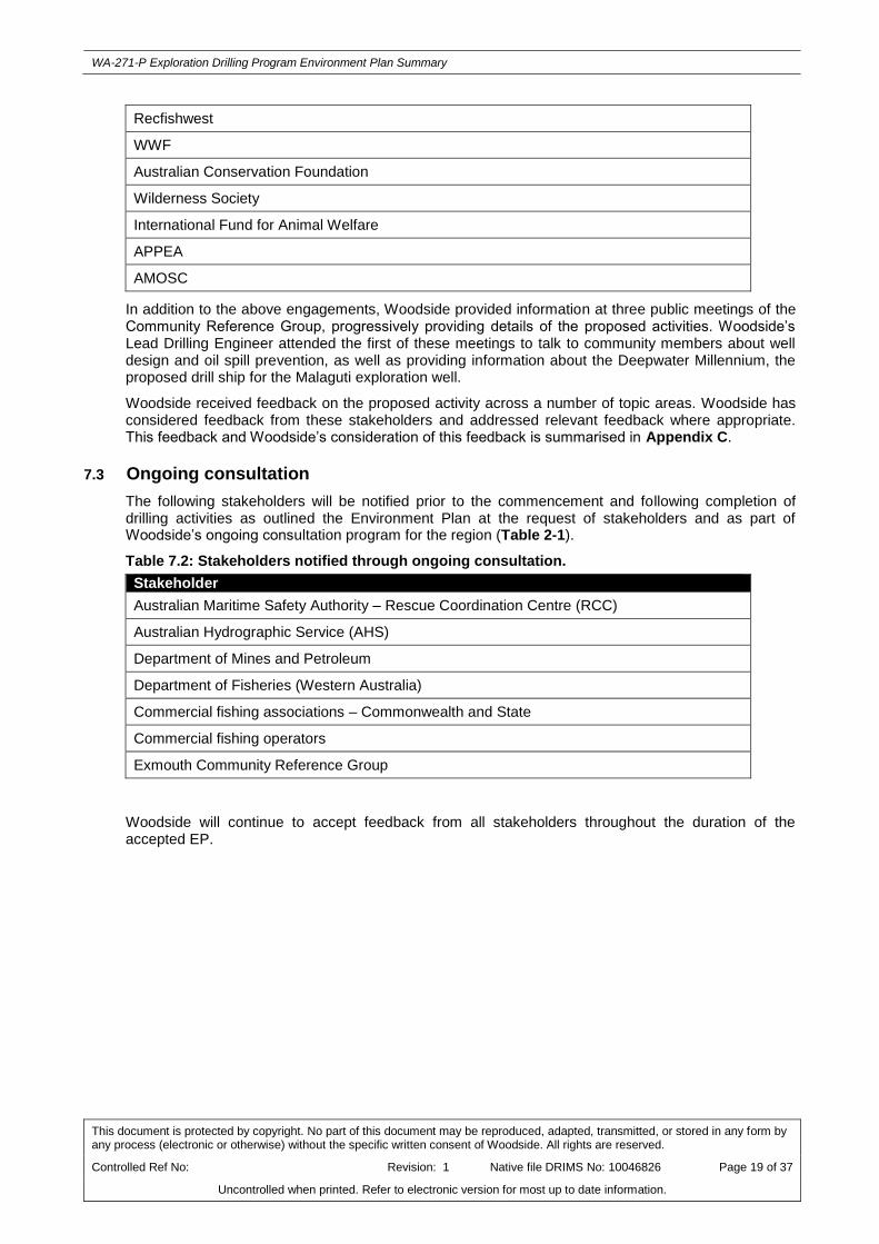
Recfishwest
WWF
Australian Conservation Foundation
Wilderness Society
International Fund for Animal Welfare
APPEA
AMOSC
In addition to the above engagements, Woodside provided information at three public meetings of the Community Reference Group, progressively providing details of the proposed activities. Woodside’s Lead Drilling Engineer attended the first of these meetings to talk to community members about well design and oil spill prevention, as well as providing information about the Deepwater Millennium, the proposed drill ship for the Malaguti exploration well.
Woodside received feedback on the proposed activity across a number of topic areas. Woodside has considered feedback from these stakeholders and addressed relevant feedback where appropriate. This feedback and Woodside’s consideration of this feedback is summarised in Appendix C.
7.3 Ongoing consultation
The following stakeholders will be notified prior to the commencement and following completion of drilling activities as outlined the Environment Plan at the request of stakeholders and as part of Woodside’s ongoing consultation program for the region (Table 2-1).
Table 7.2: Stakeholders notified through ongoing consultation.
Stakeholder
Australian Maritime Safety Authority – Rescue Coordination Centre (RCC)
Australian Hydrographic Service (AHS)
Department of Mines and Petroleum
Department of Fisheries (Western Australia)
Commercial fishing associations – Commonwealth and State
Commercial fishing operators
Exmouth Community Reference Group
Woodside will continue to accept feedback from all stakeholders throughout the duration of the accepted EP.

WA-271-P Exploration Drilling Program Environment Plan Summary
This document is protected by copyright. No part of this document may be reproduced, adapted, transmitted, or stored in any form by any process (electronic or otherwise) without the specific written consent of Woodside. All rights are reserved.
Controlled Ref No: Revision: 1 Native file DRIMS No: 10046826 Page 20 of 37
Uncontrolled when printed. Refer to electronic version for most up to date information.
8. TITLEHOLDER NOMINATED LIAISON PERSON
Under Regulation 15, the Nominated Liaison Person for this activity is:
Gary Jones
Well Delivery Manager
Woodside Energy Ltd
Woodside Plaza, 240 St Georges Terrace, Perth WA 6000
For further information about this activity, please contact:
Tony Johnson
Manager Corporate Affairs, Operations
Woodside Energy Ltd
Woodside Plaza, 240 St Georges Terrace,
Perth WA 6000
T: +61 8 9348 4000
Please direct email enquiries to our website:
http://www.woodside.com.au/Pages/Contact-Us.aspx
Toll free: 1800 442 977

WA-271-P Exploration Drilling Program Environment Plan Summary
This document is protected by copyright. No part of this document may be reproduced, adapted, transmitted, or stored in any form by any process (electronic or otherwise) without the specific written consent of Woodside. All rights are reserved.
Controlled Ref No: Revision: 1 Native file DRIMS No: 10046826 Page 21 of 37
Uncontrolled when printed. Refer to electronic version for most up to date information.
APPENDIX A: ENVIRONMENTAL IMPACTS AND RISKS

WA-271-P Exploration Drilling Program Environment Plan Summary
This document is protected by copyright. No part of this document may be reproduced, adapted, transmitted, or stored in any form by any process (electronic or otherwise) without the specific written consent of Woodside. All rights are reserved.
Controlled Ref No: Revision: 1 Native file DRIMS No: 10046826 Page 22 of 37
Uncontrolled when printed. Refer to electronic version for most up to date information.
Source of Risk (Hazard) Potential Environmental Impact
Residual Risk
Control Mitigation Measures
Planned (routine and non-routine) Activities
Proximity of drill rig and support vessels to third party vessels (commercial shipping and fishing)
Short-term, localised interference with or displacement of other sea users (e.g. fishing and shipping).
Low Compliance with Marine Orders 30 (prevention of Collisions)
Compliance with Marine Orders 21 (Safety of Navigational and Emergency Procedures)
Notify Australian Hydrographic Service (AHS) of activities and movements and consultation fact sheets
Notify AMSA Rescue Coordination Centre (RCC) of activity prior to commencement and on completion of activity.
Notify AHS to generate Maritime Safety Information Notifications and Notice to Mariners
Send consultation Factsheet to State and Commonwealth fisheries
Maintain (actively enforce) 500m safety/exclusion zone around drill rig/drillship
Drill rig anchoring, DP station holding (transponders), ROV use near the seabed
Temporary and localised disturbance of soft seabed sediments from anchoring, location of transponders and ROV activities.
Low Woodside Well Location and Site Appraisal Data Sheet (WLSADS) completed for well locations to summarise the likelihood of potential well specific hazards and drilling constraints
Mooring Analysis Design Report completed and implemented during anchor deployment as per Woodside Anchor Handling and Marine Operations Standard and Woodside Engineering Standard – Rig Equipment and Woodside Engineering Standard Mobile Offshore Drilling Unit Mooring Design
Consultation with AHO, in the event that the wellhead assembly cannot be removed, to establish any charting requirements
Generation of noise from drill rig/drillship, vessels and ROV during normal operations (excluding VSP)
Temporary and minor behavioural disturbance (e.g. avoidance or attraction) to fauna, including protected marine mammal species.
Low Compliance with EPBC Regulations 2000 – Part 8 Division 8.1 Interacting with cetaceans
Generation of acoustic signals from VSP
Temporary and minor behavioural disturbance (e.g. avoidance of local area 500 m from source) to fauna, including protected marine mammal species.
Low Compliance with Woodside approved procedure, which aligns with the EPBC Act policy Statement 2.1, to manage Potential interactions between VSP and threatened and migratory cetacean species listed under the EPBC Act.
Crew undertake specific training for cetacean observation
Internal combustion engines on drill rig/drillship and support vessels
Reduced local air quality from atmospheric emissions.
Low Compliance with Marine Order 97 (marine pollution prevention – air pollution)

WA-271-P Exploration Drilling Program Environment Plan Summary
This document is protected by copyright. No part of this document may be reproduced, adapted, transmitted, or stored in any form by any process (electronic or otherwise) without the specific written consent of Woodside. All rights are reserved.
Controlled Ref No: Revision: 1 Native file DRIMS No: 10046826 Page 23 of 37
Uncontrolled when printed. Refer to electronic version for most up to date information.
Source of Risk (Hazard) Potential Environmental Impact
Residual Risk
Control Mitigation Measures
Routine and non-routine discharges: drill rig/drillship and vessels
Localised and temporary eutrophication of the water column and localised and temporary adverse effect to marine biota.
Localised and temporary effects to water quality and marine biota.
Low Compliance with Marine Orders 95 (pollution prevention – Garbage).
Compliance with Marine Orders 96 (pollution prevention – Sewage).
Vessel sewerage system capacity suitable for full crew as per Woodside’s Engineering Standard – Rig Equipment
Management of bilge water – if bilge is contaminated with hydrocarbons it must be contained and disposed of onshore unless oil content is less than 15 ppm (without dilution) or an approved oil/water separator is used for treatment.
Routine discharge of drill cuttings to the seabed and the marine environment.
Localised burial of benthic habitats and associated biota. Benthic biota of this seabed area is identified of a general low sensitivity and representative of the wider region. Localised and temporary minor effects to water quality (e.g. turbidity increase) and marine biota in offshore waters.
The fate of drill cuttings and fluids was investigated using a numerical dispersion model resulting in:
localised burial of benthic habitats and associated biota, within ~150m of the well site;
rapid dilution of Total Suspended Sediments (TSS; e.g. turbidity) concentrations resulting in localised and temporary minor effects to water quality and marine biota in offshore waters; and
no sedimentation deposition or TSS concentration inputs to the Ningaloo WHA.
Low Use of solids control equipment (SCE): Shale shakers and centrifuges prior to discharge
Discharge cuttings below the water line (to reduce carriage by surface currents to keep impacts localised) as per Woodside Engineering Standard – Rig Equipment
WBM used as per Woodside Environmental Performance Standards – Operating Standard and Woodside Drilling and Completions Operations Manual: Drilling and Completions Fluids Procedure
Implement slim well design to reduce volume of cuttings generated

WA-271-P Exploration Drilling Program Environment Plan Summary
This document is protected by copyright. No part of this document may be reproduced, adapted, transmitted, or stored in any form by any process (electronic or otherwise) without the specific written consent of Woodside. All rights are reserved.
Controlled Ref No: Revision: 1 Native file DRIMS No: 10046826 Page 24 of 37
Uncontrolled when printed. Refer to electronic version for most up to date information.
Source of Risk (Hazard) Potential Environmental Impact
Residual Risk
Control Mitigation Measures
Routine discharge of drilling fluids (WBM), cement, cementing fluids and sub-sea control fluids to the seabed and the marine environment.
Localised and temporary effects to water quality and marine biota.
Low Selection and approval of chemicals is as per Woodside’s Environment Procedure - Drilling and Completions Chemical Approval, Review and Improvement using the assessment principles set out in Woodside’s Environment Procedure Offshore Chemical Assessment .
Bulk operational discharges conducted under drill rig/drillships Permit to Work (PTW) system (to operate discharge valves/pumps) or risk assessed using the drill rig/drillship contractors risk assessment prompt cards.
Opportunities for reuse of drilling fluids at the end of Petroleum Activities Program reviewed across other Woodside drilling activities
Unplanned (accidents or incidents) Activities
Loss of hydrocarbons to the marine environment due to loss of well control
Contamination of water leading to toxic effects to marine biota, particularly sessile benthos in the shallow sub-tidal and intertidal zone of the coral reefs.
Oiling of marine mammals, reptiles and seabirds.
Potential medium-term interference with or displacement of other sea users (e.g. fishing and shipping).
Potential interference with activities of other regional petroleum Operators.
High Accepted Well Operations Management Plan (WOMP) and application to drill as per Offshore Petroleum and Greenhouse Gas Storage (Resource Management and Administration) Regulations 2011
Prevention: Control as per Woodside’s Engineering Standards: Well Barriers, Well Control Manual, Well Cementation and international standards Subsea BOP specification and function/pressure testing in accordance with internal Woodside Standards and international requirements
Mitigation: Subsea first response toolkit and capping stack via global service provider
Mitigation: Relief well via Mutual Aid MoU
Well Blowout Contingency Plan as per Well Blowout Contingency Planning
Prevention: Control as per Well Acceptance Criteria Procedure
Oil spill response arrangements are outlined in Appendix B of this EP Summary.

WA-271-P Exploration Drilling Program Environment Plan Summary
This document is protected by copyright. No part of this document may be reproduced, adapted, transmitted, or stored in any form by any process (electronic or otherwise) without the specific written consent of Woodside. All rights are reserved.
Controlled Ref No: Revision: 1 Native file DRIMS No: 10046826 Page 25 of 37
Uncontrolled when printed. Refer to electronic version for most up to date information.
Source of Risk (Hazard) Potential Environmental Impact
Residual Risk
Control Mitigation Measures
Loss of hydrocarbons to marine environment due to a vessel collision (e.g. support vessels or other marine users).
Minor and temporary disruption to protected species such as oiling of marine mammals, reptiles and seabirds.
Minor and temporary contamination of water which may lead to toxic effects on marine biota.
Low Compliance with Marine Order 30 (Prevention of Collisions) and Marine Order 21(Safety of navigation and emergency procedures)
Notify AHS of activities and movements and consultation fact sheets
Notify AMSA RCC of activities and movements
Maintain (actively enforce) 500 m safety/exclusion zone around drill rig/drillship
Implement Woodside Marine – Charters Instructions which define the role of support vessels
Oil spill response arrangements are outlined in Appendix B of this EP Summary.
Loss of hydrocarbons to marine environment during bunkering activities.
Minor and temporary disruption to protected species such as oiling of marine mammals, reptiles and seabirds.
Localised minor and/or temporary contamination of water which may lead to toxic effects to marine biota in offshore waters.
Medium Compliance with Marine Order 91 (Marine pollution prevention – oil) 2006
Implement Woodside Engineering Standard – Rig Equipment for bunkering hoses, spill kits, etc.
Implement Woodside’s Engineering Operating Standard – Standard – Rig Equipment for bunkering procedures
Oil spill response arrangements are outlined in Appendix B of this EP Summary.
Accidental discharge of other hydrocarbons / chemicals from drill rig/drillship or support vessel deck activities and equipment (e.g. cranes)
Localised and minor temporary effects to water quality and marine biota in offshore waters.
Medium Compliance with Marine Order 91 (Marine pollution prevention – oil) 2006
Compliance with Woodside Environment Procedure - Drilling and Completions Chemical Approval, Review and Improvement using the assessment principles set out in Woodside Environment Procedure Offshore Chemical Assessment
Implement Woodside’s Environmental Performance Operating Standard: Storage
Implement engineered barriers as per Woodside’s Engineering Standard – Rig Equipment
Deck bunding and spill response kits maintained and stocked
WA-271-P Exploration Drilling Program Environment Plan Summary
This document is protected by copyright. No part of this document may be reproduced, adapted, transmitted, or stored in any form by any process (electronic or otherwise) without the specific written consent of Woodside. All rights are reserved.
Controlled Ref No: Revision: 1 Native file DRIMS No: 10046826 Page 26 of 37
Uncontrolled when printed. Refer to electronic version for most up to date information.
Source of Risk (Hazard) Potential Environmental Impact
Residual Risk
Control Mitigation Measures
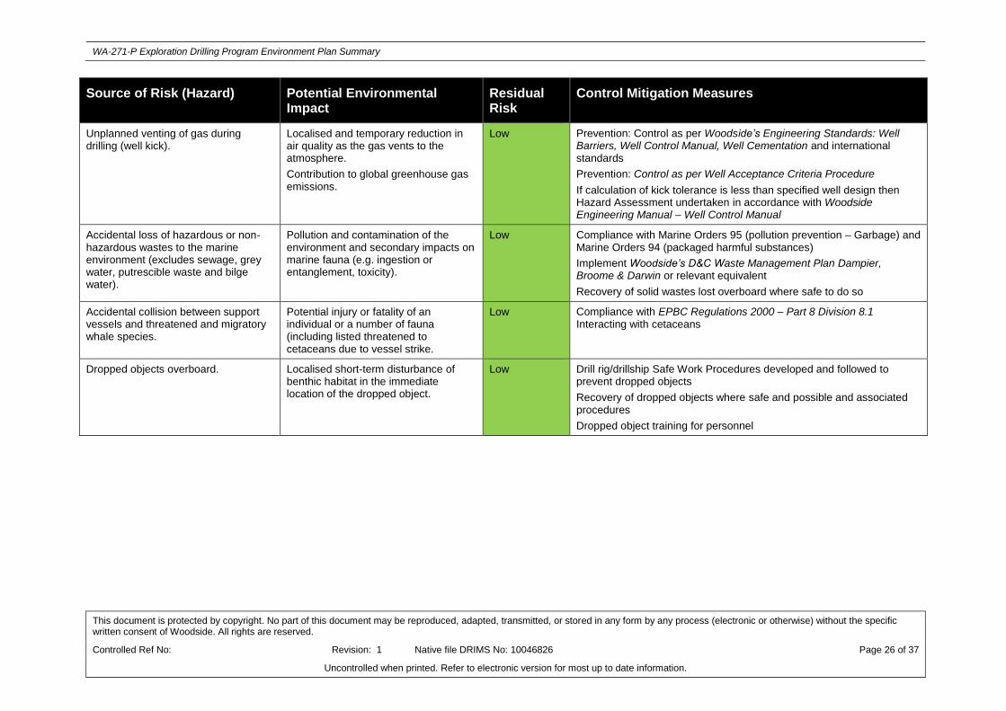
Unplanned venting of gas during drilling (well kick).
Localised and temporary reduction in air quality as the gas vents to the atmosphere.
Contribution to global greenhouse gas emissions.
Low Prevention: Control as per Woodside’s Engineering Standards: Well Barriers, Well Control Manual, Well Cementation and international standards
Prevention: Control as per Well Acceptance Criteria Procedure
If calculation of kick tolerance is less than specified well design then Hazard Assessment undertaken in accordance with Woodside Engineering Manual – Well Control Manual
Accidental loss of hazardous or non-hazardous wastes to the marine environment (excludes sewage, grey water, putrescible waste and bilge water).
Pollution and contamination of the environment and secondary impacts on marine fauna (e.g. ingestion or entanglement, toxicity).
Low Compliance with Marine Orders 95 (pollution prevention – Garbage) and Marine Orders 94 (packaged harmful substances)
Implement Woodside’s D&C Waste Management Plan Dampier, Broome & Darwin or relevant equivalent
Recovery of solid wastes lost overboard where safe to do so
Accidental collision between support vessels and threatened and migratory whale species.
Potential injury or fatality of an individual or a number of fauna (including listed threatened to cetaceans due to vessel strike.
Low Compliance with EPBC Regulations 2000 – Part 8 Division 8.1 Interacting with cetaceans
Dropped objects overboard. Localised short-term disturbance of benthic habitat in the immediate location of the dropped object.
Low Drill rig/drillship Safe Work Procedures developed and followed to prevent dropped objects
Recovery of dropped objects where safe and possible and associated procedures
Dropped object training for personnel

WA-271-P Exploration Drilling Program Environment Plan Summary
This document is protected by copyright. No part of this document may be reproduced, adapted, transmitted, or stored in any form by any process (electronic or otherwise) without the specific written consent of Woodside. All rights are reserved.
Controlled Ref No: Revision: 1 Native file DRIMS No:10046826 Page 27 of 37
Uncontrolled when printed. Refer to electronic version for most up to date information.
APPENDIX B: SUMMARY OF RESPONSE ARRANGEMENTS FROM OIL POLLUTION EMERGENCY PLAN

WA-271-P Exploration Drilling Program Environment Plan Summary
This document is protected by copyright. No part of this document may be reproduced, adapted, transmitted, or stored in any form by any process (electronic or otherwise) without the specific written consent of Woodside. All rights are reserved.
Controlled Ref No: Revision: 1 Native file DRIMS No:10046826 Page 28 of 37
Uncontrolled when printed. Refer to electronic version for most up to date information.
Woodside’s Oil Spill Planning Arrangements
Woodside’s Oil Pollution Emergency Plan (OPEP) for the proposed Petroleum Activities Program consists of the following documents:
Woodside Oil Pollution Emergency Arrangements (Australia)
This document outlines the emergency and crisis management incident command structure (ICS) and Woodside’s response arrangements to competently respond to and escalate an oil spill event. The document interfaces externally with Commonwealth, State and industry response plans and internally with Woodside’s ICS.
Woodside’s Oil Pollution Emergency Arrangements (Australia) describes Woodside’s role as a Control Agency and details the following support arrangements:
Master services agreement with Australian Marine Oil Spill Centre (AMOSC) for the supply of experienced personnel and equipment, including a subsea first response toolkit and national dispersant stockpiles
Access to Wild Well Control’s capping stack, SFRT equipment and experienced personnel for the rapid deployment and installation of a capping stack, where feasible
Participating membership (including supplementary agreement for Global Dispersant Stockpile (GDS)) with Oil Spill Resources Limited (OSRL), which allows access to OSRL’s international holding of response equipment and response capabilities, including GDS, incident management expertise and specialist personnel;
The Woodside and Australian Maritime Safety Authority (AMSA) Memorandum of Understanding (MoU) whereby AMSA, as managers of the National Plan for Maritime Environmental Emergencies, will provide support to Woodside such as response equipment from national stockpiles. The equipment stockpiles are located around Australia in strategic locations such as the ports of Dampier, Darwin and Fremantle
Other support services such as 24/7 oil spill trajectory modelling and satellite monitoring services as well as ‘on-call’ aerial, marine, logistics and waste management support
Mutual Aid Agreements with other oil and gas operators in the region for the provision of assistance in an oil spill response.
Oil Pollution First Strike Plan – WA-271-P Exploration Drilling Program
The Oil Pollution First Strike Plan – WA-271-P Exploration Drilling Program is an activity specific document providing details on the tasks required to mobilise a first strike response for the first 24 hours of a hydrocarbon (oil) spill event. These tasks include key response actions and regulatory notifications. The intent of the document is to provide immediate oil spill response guidance to the Incident Management Team until a full Incident Action Plan specific to the oil spill event is developed.
Woodside’s oil spill arrangements are tested on the drill rig within 2 weeks of commencement of drilling each well. Woodside’s broader ICS is tested at least every year, whilst exercises involving the various statutory authorities are conducted at least every five years.
Oil Spill Preparedness and Response Mitigation for WA-271-P Exploration Drilling Program
Woodside has developed an oil spill preparedness and response position in order to demonstrate that risks and impacts associated with the potential loss of hydrocarbons from the proposed Petroleum Activities Program would be mitigated and managed to as low as reasonably practicable (ALARP) and would be of an acceptable level.
The following oil spill response strategies were evaluated and subsequently pre-selected for a significant oil spill event (level 2 or 3 under the National Plan) from the proposed Petroleum Activities Program. The potential environmental risks and impacts of these strategies include:
Air emissions causing a temporary reduction in air quality
Physical presence of vessels and equipment causing disturbance to fauna from light, noise emissions or equipment blocking movement of fauna

WA-271-P Exploration Drilling Program Environment Plan Summary
This document is protected by copyright. No part of this document may be reproduced, adapted, transmitted, or stored in any form by any process (electronic or otherwise) without the specific written consent of Woodside. All rights are reserved.
Controlled Ref No: Revision: 1 Native file DRIMS No:10046826 Page 29 of 37
Uncontrolled when printed. Refer to electronic version for most up to date information.
Toxic effects of chemical dispersants on the receiving environment
Seabed disturbance impacting any benthic habitats or species when equipment, such as the capping stack, is deployed
Physical damage and loss of shoreline habitats from clean-up operations
Pollution of the marine environment from waste generated during a spill response
Physical injury and stress to wildlife if captured for treatment
The environmental risks and impacts of these strategies are identified and assessed during a pre-operational Net Environmental Benefit Analysis (NEBA) and considered as part of the ALARP and acceptability assessment. Appropriate response strategies are determined where the environmental benefit of implementing the response outweighs the potential risks and impacts of not undertaking the response. Implementation of these response strategies would be re-assessed during a spill event, on an ongoing basis, with continued used of the NEBA process and consideration of the size of spill, weather conditions and other constraints:
1. Monitor and Evaluate - To gain an understanding of the spill event, its movement and to direct mitigation activities to the optimal locations, the following operational monitoring programs are available for implementation:
Predictive modelling of hydrocarbons to assess resources at risk
Surveillance and reconnaissance to detect hydrocarbons and resources at risk
Monitoring of hydrocarbon presence, properties, behaviour and weathering in water
Pre-emptive assessment of sensitive receptors at risk; and
Monitoring of contaminated resources and the effectiveness of response and clean-up operations.
2. Well Control and Intervention – Woodside’s strategy is to minimise the volume of hydrocarbons released from an oil spill event. Woodside plans to deploy the following controls specific to well loss of containment scenarios, if required for the proposed Petroleum Activities Program:
Subsea dispersant injection (SSDI) at the subsea release
Subsea first response toolkit (SFRT) deployment to clear debris, assess the well at the sea bed and, if practicable, attempt to close the BoP
Subsea source control (deployment of a Capping Stack); and
Well intervention (relief well drilling).
3. Surface Dispersant Application – Surface dispersant application may reduce surface oil and therefore prevent, or reduce the scale of, shoreline contact. Priority would be placed on treating surface oil which could contact receptor areas in the shortest timeframe. The following objectives for surface dispersant application have been identified:
Commence marine dispersant application to the advancing front of the spill, unless clearly determined that no net environmental benefit would be gained
Mobilise sufficient marine and airborne resources to:
- maintain control of the advancing front
- match treatment to the rate of a continuous well release as soon as practicable (and thus minimise the initial peak of untreated surface oil); and
- limit the age of surface accumulations of untreated hydrocarbons from well releases to maintain dispersant efficacy.
4. Dispersant Supply Chain – The strategies for application of surface and subsea dispersant require that stockpiles and supply chains are established which would support the maximum demand created by the selected dispersant delivery options and resources. The objectives for dispersant supply chain include:

WA-271-P Exploration Drilling Program Environment Plan Summary
This document is protected by copyright. No part of this document may be reproduced, adapted, transmitted, or stored in any form by any process (electronic or otherwise) without the specific written consent of Woodside. All rights are reserved.
Controlled Ref No: Revision: 1 Native file DRIMS No:10046826 Page 30 of 37
Uncontrolled when printed. Refer to electronic version for most up to date information.
Provide stocks on the vessels to be used for first response and in the Exmouth and Dampier supply bases, with appropriate in-field marine logistics, to support the first response
Establish a supply chain to meet the build-up of dispersant demand to plateau
Maintain the supply chain to sustain operations at the potential peak application capacity.
5. Containment and Recovery – Involves the physical containment and mechanical removal of hydrocarbons from the marine environment. Suitable vessels would be drawn from Woodside’s integrated fleet, other operators in the region and from the charter market. Open water containment and recovery equipment (e.g. booms and skimmers) would be sourced from Woodside’s own equipment, AMSA, AMOSC and OSRL stockpiles.
6. Shoreline Protection – Shoreline protection equipment would be deployed either from a vessel or from the shore, depending on the prevailing conditions, shoreline type and access. Additional resources would be mobilised depending on the scale of the event to increase the number of shorelines being protected.
7. Shoreline Cleanup – Woodside has access to equipment stockpiles to support initial response requirements at priority receptors and would supplement resources, depending on the type of cleanup required, through contractors. Some equipment maybe procured locally on the day with additional equipment being sourced within Western Australia, interstate and internationally, commensurate with the scale and progressive nature of shoreline impact.
8. Oiled Wildlife Response – Staging sites will be established for shoreline or vessel based oiled wildlife response teams. Once recovered to a staging site, wildlife will be transported to the designated oiled wildlife facility for stabilisation and treatment.
9. Waste Management – The objectives of Woodside’s waste management response are:
To mobilise waste storage and transport resources on day one of a potential oil spill event to support containment and recovery and shoreline protection responses; and
Arrange for sufficient waste storage, handling, transport and disposal capability to support continuous response operations.
To achieve these objectives, Woodside has access to waste storage in Exmouth and Karratha as well as waste storage equipment from AMOSC, AMSA and OSRL.
Scientific Monitoring
In addition to the above response strategies, a scientific monitoring program (SMP) will be activated following a significant oil spill (defined as a level 2 or 3 spill). The nature and scale of the spill event would dictate the implementation and operational timing of the SMP. Ten targeted scientific monitoring programs may be implemented to address a range of physical-chemical (water and sediment) and biological receptors (species and habitats) including EPBC Act listed species, environmental values associated with Protected Areas and socio-economic values such as fisheries. The SMPs to be activated are as follows:
Desk-based review and assessment of hydrocarbons in marine waters;
Assessment of the presence, quantity and character of hydrocarbons in marine sediments;
Assessment of impacts and recovery of subtidal and intertidal benthos;
Assessment of impacts and recovery of mangroves / saltmarsh;
Assessment of impacts and recovery of seabird and shorebird populations;
Assessment of impacts and recovery of nesting marine turtle populations;
Assessment of impacts to pinniped (seal and sea lion) colonies including haul-out site populations;
Desk-based assessment of impacts to other non-avian marine megafauna;
Assessment of impacts and recovery of marine fish associated with various habitats; and
WA-271-P Exploration Drilling Program Environment Plan Summary
This document is protected by copyright. No part of this document may be reproduced, adapted, transmitted, or stored in any form by any process (electronic or otherwise) without the specific written consent of Woodside. All rights are reserved.
Controlled Ref No: Revision: 1 Native file DRIMS No:10046826 Page 31 of 37
Uncontrolled when printed. Refer to electronic version for most up to date information.
Assessment of physiological impacts to commercially important fish and shellfish species (fish health and seafood quality/safety) and recovery.
WA-271-P Exploration Drilling Program Environment Plan Summary
This document is protected by copyright. No part of this document may be reproduced, adapted, transmitted, or stored in any form by any process (electronic or otherwise) without the specific written consent of Woodside. All rights are reserved.
Controlled Ref No: Revision: 1 Native file DRIMS No:10046826 Page 32 of 37
Uncontrolled when printed. Refer to electronic version for most up to date information.
APPENDIX C: SUMMARY OF STAKEHOLDER FEEDBACK AND WOODSIDE’S RESPONSE

WA-271-P Exploration Drilling Program Environment Plan Summary
This document is protected by copyright. No part of this document may be reproduced, adapted, transmitted, or stored in any form by any process (electronic or otherwise) without the specific written consent of Woodside. All rights are reserved.
Controlled Ref No: Revision: 1 Native file DRIMS No: 10046826 Page 33 of 37
Uncontrolled when printed. Refer to electronic version for most up to date information.
Topic Summary of Stakeholder Feedback Woodside assessment of feedback
Woodside Response
Maritime safety Stakeholder requested that:
Additional caution should be exercised with respect to marine traffic in the vicinity of the proposed Malaguti well location.
At all times vessels will need to be active in maintaining communications with any and all commercial shipping in the area. It also noted that any related avoiding action by commercial shipping, should it be necessary, should not increase and/or compound the navigational risk to other shipping in the vicinity.
AMSA’s Rescue Coordination Centre (RCC) is contacted prior to, and at the end of drilling for promulgation of Auscoast warning
AHS is contacted no less than two weeks prior to drilling to support Notice to Mariners, and
AMSA is informed after the activity of any commercial shipping activity
Woodside acknowledges the requests, which are consistent with requirements for other activities for vessel movements to be reported to the RCC, AHS and AMSA.
The details the risk assessment for the physical presence of the drill rig/drillship and support vessels and interactions with other users in the area including shipping is detailed in the EP and the associated controls mitigation measures are provided in Appendix A of this EP Summary.
Woodside to report activity start and end dates and vessel movements to the RCC, AHS and AMSA as per the requests.
Woodside to provide feedback following drilling
Commercial fishing Stakeholder advised Woodside that its advice was valid for 6 months from 17 September 2014 and was valid for the duration of the EP subject to the activity commencing within six months and provision of regular updates.
Stakeholder provided advice on State fisheries in or close proximity to the proposed activities. It also noted that
Woodside acknowledges the advice provided by the Stakeholder.
Woodside provided advice on State fisheries in or close proximity to the proposed activities. It also noted that customary, recreational and charter fishing may occur within
Woodside acknowledges the response and have included the Stakeholder on the Stakeholder distribution list for ongoing advice prior to the start and upon completion of the activity.
Woodside will reengage if this activity occurs outside of the 6 month advice window.
WA-271-P Exploration Drilling Program Environment Plan Summary
This document is protected by copyright. No part of this document may be reproduced, adapted, transmitted, or stored in any form by any process (electronic or otherwise) without the specific written consent of Woodside. All rights are reserved.
Controlled Ref No: Revision: 1 Native file DRIMS No: 10046826 Page 34 of 37
Uncontrolled when printed. Refer to electronic version for most up to date information.
Topic Summary of Stakeholder Feedback Woodside assessment of feedback
Woodside Response
customary, recreational and charter fishing may occur within the proposed area of activities
Stakeholder recommended that Woodside maintain contact with WAFIC, Recfishwest and directly with fishers about proposed activities.
Stakeholder provided contacts for notification in the event of an oil spill or pollutant discharge and requested that should such an event occur that contact is made with 24 hours.
In the event of a spill the stakeholder requested collection of baseline marine data to compare against any post-spill monitoring to determine the extent of impact in the event of an oil spill.
Stakeholder requested that strategies be included in the EP to mitigate the impact of oil spill on fish spawning grounds and nursery areas, and provided a list of species.
Stakeholder also noted that all vessels undertaking activities in Western Australian waters to undertake measures to minimise the risk of translocating aquatic pests and diseases. Stakeholder also requests vessel owners and operators to immediately report known or suspected introduced aquatic pests or diseases detected in Western Australian waters.
Stakeholder requested that all potential
the proposed area of activities
Appendix A of this EP Summary outlines the risk and impact assessment of the activity, including impacts on commercial fishing, and the controls that will be applied to mitigate and manage impacts. The aspects that have been raised by the Stakeholder in relation to oil spills have been assessed and appropriate controls put in place.
Woodside notes the Stakeholder’s interest in being advised and will be included as part of stakeholder identification, prioritisation and engagement in accordance with overall incident response in the event of an oil spill or pollutant discharge.
Based on the advice provided by the Stakeholder Woodside identified and provided updated advice to the fishing operators and agencies within or in close proximity to the Operational Area prior to the commencement of activities, and will continue ongoing consultation
Woodside notes the Fish Resources Management Regulations 1995, and assesses and manages invasive marine species risk for all vessels (including drill rig/drillship) through the Woodside Invasive Marine Species Management Plan.
Appropriate spill response plans are in place.
Known baseline information related to fish species (including spawning and nursery seasons) and relevant nature and scale of the activities is described in the EP.

WA-271-P Exploration Drilling Program Environment Plan Summary
This document is protected by copyright. No part of this document may be reproduced, adapted, transmitted, or stored in any form by any process (electronic or otherwise) without the specific written consent of Woodside. All rights are reserved.
Controlled Ref No: Revision: 1 Native file DRIMS No: 10046826 Page 35 of 37
Uncontrolled when printed. Refer to electronic version for most up to date information.
Topic Summary of Stakeholder Feedback Woodside assessment of feedback
Woodside Response
impacts to fisheries, fish and fish habitat are acknowledged in the EP and strategies for minimisation and mitigation defined.
Stakeholder indicated that the response is only valid for six months and requested that Woodside re-consult with the Stakeholder, Recfishwest and individual fisheries three months prior to the commencement of the activity, with any objections or claims resolved prior to the commencement of the activity.
Incident Response Stakeholder acknowledged it had received advice about Woodside’s proposed petroleum activities and that they would be assessed by NOPSEMA under the OPGGS Regulations.
Stakeholder requested incident response arrangements, including an overview of oil spill trajectory modelling and potential impact to State waters.
Woodside acknowledges this response and concurs with the Stakeholder’s view.
Woodside has long-standing practice of not releasing oil spill modelling data or management plans to stakeholders unless for assessment or response plan development. Woodside acknowledges the Department of Transport as the relevant jurisdictional authority for consultation on oil spill preparedness in Western Australian waters.
Woodside emailed a response to the Stakeholder providing an overview of oil spill preparedness, including corporate and regional preparedness.
Activity location and potential impacts and management measures
Stakeholder noted the proximity of the proposed well location to the Commonwealth Marine Park Boundary and recommended Woodside to halt plans for the proposed activity.
Woodside acknowledges the Stakeholder’s response.
Woodside recognises the environmental and social importance of the region
Woodside emailed a response to the stakeholder providing an overview of proposed activities, environmental management measures relating to marine fauna protection and routine discharges and oil spill preparedness,

WA-271-P Exploration Drilling Program Environment Plan Summary
This document is protected by copyright. No part of this document may be reproduced, adapted, transmitted, or stored in any form by any process (electronic or otherwise) without the specific written consent of Woodside. All rights are reserved.
Controlled Ref No: Revision: 1 Native file DRIMS No: 10046826 Page 36 of 37
Uncontrolled when printed. Refer to electronic version for most up to date information.
Topic Summary of Stakeholder Feedback Woodside assessment of feedback
Woodside Response
Stakeholder sought details of measures to protect marine fauna and ecosystems from vessel activities and to prevent vessel collisions and groundings.
Stakeholder sought details of routine discharges and legal requirements; and other waste products.
Stakeholder sought a copy of Woodside’s oil spill response plan, including details on equipment, materials and response timeliness.
Stakeholder sought additional well plan details.
believes it has the capabilities and experience to safely and responsibly manage the drilling program.
Woodside has evaluated planned and non-planned environmental risks listed in section 5.3 and 5.4 and believes it has the appropriate prevention and mitigation controls in place for the activity.
Loss of well integrity has been evaluated as having a high level of residual risk. As described in Section 5.1, Woodside considers high residual risks as acceptable if ALARP is demonstrated using good industry practice and risk based analysis, if legislative requirements are met and societal concerns are accounted for, and the alternative control measures are grossly disproportionate to the benefit gained.
Woodside looks after the communities and environments in which it operates. Risks are inherent in drilling activities; however through sound management, systematic application of policies, standards, procedures and processes, Woodside considers
including corporate and regional preparedness.

WA-271-P Exploration Drilling Program Environment Plan Summary
This document is protected by copyright. No part of this document may be reproduced, adapted, transmitted, or stored in any form by any process (electronic or otherwise) without the specific written consent of Woodside. All rights are reserved.
Controlled Ref No: Revision: 1 Native file DRIMS No: 10046826 Page 37 of 37
Uncontrolled when printed. Refer to electronic version for most up to date information.
Topic Summary of Stakeholder Feedback Woodside assessment of feedback
Woodside Response
that despite this risk, the extremely low likelihood of loss of well control is acceptable.
By providing additional measures to prevent loss of well control in addition to oil spill response measures that are commensurate with the residual risk, location and sensitivity of the receiving environment (including social and aesthetic values), Woodside believes that this addresses societal concerns to an acceptable level.