vro.agriculture.vic.gov.auvro.agriculture.vic.gov.au/.../$FILE/tech55_word.docxvro.agriculture.vic.gov.au...
79
LAND SUITABILITY FOR SELECTED HORTICULTURAL CROPS IN VICTORIA January 1999 Technical Report No. 55 M.R. Bluml, J.R. Williamson, C.N. Feuerherdt & D.R. Morey CENTRE FOR LAND PROTECTION RESEARCH and INSTITUTE FOR HORTICULTURAL DEVELOPMENT Cost Competitive Horticulture (Project No. 06380) A Victorian Government Agriculture Food Initiative
Transcript of vro.agriculture.vic.gov.auvro.agriculture.vic.gov.au/.../$FILE/tech55_word.docxvro.agriculture.vic.gov.au...

LAND SUITABILITY FOR SELECTED HORTICULTURAL CROPS IN VICTORIA
January 1999
Technical Report No. 55
M.R. Bluml, J.R. Williamson, C.N. Feuerherdt & D.R. Morey
CENTRE FOR LAND PROTECTION RESEARCH and
INSTITUTE FOR HORTICULTURAL DEVELOPMENT
Cost Competitive Horticulture (Project No. 06380)A Victorian Government Agriculture Food Initiative

ISBN 07311 4278 0
ISSN 1038-216X
Contributions:
Martin Bluml – TextJohn Williamson - TextCraig Feuerherdt – GIS mappingDavid Morey – Project Coordination
User NoteThe map information provided in this report (scale 1:3 250 000) and the associated map set (scale 1:1 000 000) is suitable for broadscale (statewide) planning purposes rather than regional or paddock level applications. While the land suitability classes indicate the likely performance of land under horticulture, there are likely to be non representative land types present given the data limitations and scale of the mapping undertaken. Therefore, the authors strongly advise that detailed site investigation be undertaken before proceeding with development.
The associated map set can be viewed at the Centre for Land Protection Research, Bendigo, and Institute for Horticultural Development, Knoxfield, Victoria.
Bluml, Martin
Land suitability for selected horticultural crops in Victoria
Bibliography
Includes index
ISBN 0 7311 4278 0
1. Land capability for agriculture – Victoria. 2. Crops and soils - Victoria. 3. Crops and water - Victoria 4. Sustainable agriculture – Victoria. 5. Land use, Rural – Victoria. I. Bluml, Martin. II Centre for Land Protection Research (Vic) III Institute for Horticultural Development (Vic.). IV. Title. (Series : Technical report (Centre for Land Protection Research (Vic.)) ; no. 55).
631.47945
Copyright Department of Natural Resources & Environment 1999
This publication may be of assistance to you but the State of Victoria and its employees do not guarantee that the publication is without flaw of any kind or is wholly appropriate for your particular purposes and therefore disclaims all liability for any error, loss or other consequence which may arise from you relying on any information in this publication
FRONT COVER PHOTO: A potato crop growing in Thorpdale, Victoria
Centre for Land Protection Research

FOREWORD
Victorian horticultural exports have been growing by 14% annually, and have the potential to increase to 17% through improved competitiveness along the production and marketing chain, in conjunction with improved consistency of quality and supply. Improving our export competitiveness is vital if Victoria is to take advantage of the "westernisation" of Asia that is driving international trade in horticultural products.
The Cost Competitive Horticulture (CCH) project is a Victorian government Agriculture and Food Initiative. CCH focuses on increasing the competitiveness of the production supply chain through to export customers not addressed in the ExpHORT 2000 projects. This project provides an innovative and comprehensive approach to developing export opportunities and investment in the potato and vegetable industries.
This report and the accompanying maps have been developed through a synergy approach between the Centre for Land Protection Research (CLPR, Bendigo) and the Institute for Horticultural Development (IHD, Knoxfield) which both fall under the Victorian State Government Department of Natural Resources and Environment (DNRE). The report and maps provide a sound foundation for the delivery of two of the key strategies identified as being crucial for the success of the CCH project:
1. To develop and drive adoption of "best practice systems" to achieve a scale of operation to take advantage of export opportunities.
2. To package and facilitate investment to realise these export opportunities.
The background work needed to deliver a unique package of information and maps would not be possible without the input of many people in the DNRE organisation. In particular, the staff at the Centre for Land Protection Research who have been able to help the CCH project team meet its objectives through the completion of this report and accompanying maps.
David Morey
Industry Development Officer- Horticulture
Institute for Horticultural Development, Knoxfield
Centre for Land Protection Research i

EXECUTIVE SUMMARY
Further opportunities for the development of horticultural enterprises are available in Victoria. This report investigates opportunities where horticultural development can potentially occur by identifying areas of land that would support sustainable crop production by meeting plant production requirements, in conjunction with the protection of the natural resource base.
The consideration of the following components (climate, landscape, soil, groundwater, surface water, and the presence of public land) has led to the generation of an individual land suitability map for each of the following crops;
potatoes (summer and winter crop),
carrots (summer and winter crop),
cauliflower/broccoli (summer and winter crop),
lettuce (summer and winter crop),
asparagus (summer crop only),
sweet corn (summer crop only), and
fresh market tomatoes (summer crop only).
Analysis of climate, landscape and soil factors have allowed the identification of areas of land which have been classed as either highly suitable, moderately suitable, or not suitable for each crop in question. Each land suitability class has been determined by the most limiting component or sub-component. Where no limiting component or sub-component is present, the land has a high probability of being suitable for horticulture.
Overlay maps have been generated which show;
Access to potential supplementary water supplies (both surface and ground waters) which could be used for irrigation.
Catchment Management Authority boundaries, and
Public land.
All maps have been produced at a scale of 1:3 250 000, and are suitable for broad scale planning purposes only. Further site analysis will be required prior to investment.

Based on analysis of the statewide crop suitability maps the following table represents areas of land within Victoria which are suitable, moderately suitable or not suitable to the production of the crops as given.
Crop Highly suitable (ha)
Moderately suitable (ha)
Not suitable(ha)
Potatoes - summer 1 021 525 4 272 350 9 630 125Potatoes - winter 83 475 864 025 13 976 500
Carrots - summer 826 150 4 467 725 9 630 125Carrots - winter Nil 947 500 13 976 500Cauliflower/broccoli -summer
723 575 5 099 075 9 101 350
Cauliflower/broccoli - winter
Nil 947 500 13 976 500
Lettuce - summer 612 000 3 279 450 11 032 550Lettuce - winter 875 731 550 14 191 575Asparagus - summer 828 100 3 456 175 10 639 725Sweet corn - summer 424 900 11 868 300 2 630 825Fresh market tomatoes - summer
414 850 11 878 075 2 631 100

CONTENTSForeword........................................................................................................................ i
Executive Summary....................................................................................................... ii
1 Introduction.........................................................................................................1
2 Land Suitability Framework.................................................................................2
3 Land Suitability Assessment Methodology..........................................................4
3.1 Biophysical factors.................................................................................4
3.2 Infrastructure factors..............................................................................5
3.3 Institutional factors.................................................................................5
4 Land Suitability Assessment for Selected Horticultural Crops.............................6
4.1 Potatoes (summer crop).........................................................................7
4.2 Potatoes (winter crop)..........................................................................11
4.3 Carrots (summer crop).........................................................................15
4.4 Carrots (winter crop).............................................................................19
4.5 Broccoli and Cauliflower (summer crop)...............................................23
4.6 Broccoli and Cauliflower (winter crop)..................................................27
4.7 Lettuce (summer crop).........................................................................35
4.8 Lettuce (winter crop).............................................................................39
4.9 Asparagus (summer crop)....................................................................43
4.10 Sweet Corn (summer crop)..................................................................47
4.11 Fresh Market Tomatoes (summer crop)...............................................51
5 Data Sources....................................................................................................55
6 Data Limitations................................................................................................55
7 References........................................................................................................55
8 Acknowledgements...........................................................................................56
Appendix 1.................................................................................................................. 57
List of Tables2.1 Land suitability framework for investment decision making..............................2
3.1 Land suitability definitions for horticulture.........................................................5
4.1 Components, sub-components and sub-component critical values for determining land suitability for potatoes (summer crop)...................................7
4.2 Components, sub-components and sub-component critical values for determining land suitability for potatoes (winter crop).....................................11
4.3 Components, sub-components and sub-component critical values for determining land suitability for carrots (summer crop)....................................15
4.4 Components, sub-components and sub-component critical values for determining land suitability for carrots (winter crop)........................................19
4.5 Components, sub-components and sub-component critical values for determining land suitability for broccoli and cauliflower (summer crop)...............................................................................................................23

4.6 Components, sub-components and sub-component critical values for determining land suitability for broccoli and cauliflower (winter crop).............27
4.7 Components, sub-components and sub-component critical values for determining land suitability for lettuce (summer crop).....................................31
4.8 Components, sub-components and sub-component critical values for determining land suitability for lettuce (winter crop)........................................35
4.9 Components, sub-components and sub-component critical values for determining land suitability for asparagus (summer crop)..............................39
4.10 Components, sub-components and sub-component critical values for determining land suitability for sweet corn (summer crop)..............................43
4.11 Components, sub-components and sub-component critical values for determining land suitability for fresh market tomatoes (summer crop)...........47
5.1 Geomorphic Unit Codes.................................................................................51
5.2 Landform Unit Codes......................................................................................52
List of Maps4.1 Statewide crop suitability - potatoes (summer crop).........................................9
4.2 Statewide crop suitability - potatoes (winter crop)...........................................13
4.3 Statewide crop suitability - carrots (summer crop)..........................................17
4.4 Statewide crop suitability - carrots (winter crop).............................................21
4.5 Statewide crop suitability - broccoli and cauliflower (summer crop)................25
4.6 Statewide crop suitability - broccoli and cauliflower (winter crop)...................29
4.7 Statewide crop suitability - lettuce (summer crop)..........................................33
4.8 Statewide crop suitability - lettuce (winter crop)..............................................37
4.9 Statewide crop suitability - asparagus (summer crop)....................................41
4.10 Statewide crop suitability - sweet corn (summer crop)....................................45
4.11 Statewide crop suitability - fresh market tomatoes (summer crop).................49
Rear Map Pocket
Groundwater and surface water resources......................................................................
Catchment Management Authorities...............................................................................

LAND SUITABILITY FOR SELECTED HORTICULTURAL CROPS IN VICTORIAJanuary 1999Centre for Land Protection Research, Department of Natural Resources & Environment, 22 Osborne St., Bendigo. Vic. 3550.1 INTRODUCTION
Annual food production and processing has been growing steadily throughout the 1990’s as national exports of processed food continue to grow. Victoria currently produces 30% of the nation’s processed food and has increased its market share of national exports from 20% to 26% over the past three years. Forecasts suggest that agribusiness organisations will continue to grow to meet new export demands. Consequently there has been significant interest in determining land suitable for horticultural development.
Victoria has a wide range of land types, which support various forms of horticulture. To facilitate the future development of sustainable horticultural enterprises, this study has identified suitable land types for the production of selected horticultural crops within Victoria. This study was funded as part of the Agriculture and Food Initiative - Cost Competitive Horticulture Project (Project No. 06380).
There is considerable potential to further develop horticultural enterprises in regional Victoria, particularly where infrastructure and services can support food processing facilities. Expansion of these horticultural enterprises will also result in increased on-farm income and regional employment opportunities.
This report utilises broad information on the nature of the land, soil, climate, and key crop productivity information, to assess land suitability for selected horticultural crops in Victoria. The Statewide Land Systems (Rowan, 1990) provide much of the core information for the analysis of land suitability, while key crop productivity requirements were provided by Agriculture Victoria industry representatives. The analysis of land suitability considers both the productivity requirements and the potential for land and water degradation posed by the horticultural enterprises.
This report contains a series of maps highlighting the suitability for summer production (October to April) and winter production (May to September) based primarily on climate, landform and soil parameters for the following horticultural crops;
Potatoes (winter and summer production)
Carrots (winter and summer production)
Broccoli/Cauliflower (winter and summer production)
Lettuce (winter and summer production)
Asparagus (summer production only)
Sweet Corn (summer production only)
Fresh Market Tomatoes (summer production only)
In addition, map overlays highlighting ground or surface water resources and Catchment Management Authority boundaries have been included. This will assist with the analysis and dissemination of information to key investment groups and land management authorities. These overlays are contained in a pocket at the back of this report.
2 LAND SUITABILITY FRAMEWORKThe identification of land suitable for the production of horticultural crops can be a complex affair involving decisions relating to environmental, economic and institutional factors. It can be argued that practically all land is suitable for horticultural production,

given sufficient inputs and management. However in reality, certain land types will be capable of higher levels of production with minimal risk of land and water degradation. It is prudent to steer potential investors to these areas.The role of identifying areas with a comparative advantage can be taken by government in an attempt to direct investment to areas with a low economic and environmental risk. This task, when undertaken at the broadscale can be defined as a land suitability analysis. A land suitability analysis can utilise environmental, biophysical (landform, soils, climate), infrastructure, service and regulatory information to determine areas where production and/or processing advantages exist. This information can subsequently be used by investors to target areas for further investigation. Detailed site investigation can then be undertaken by investors (Table 2.1) as part of their risk assessment and decision making process. Forces that will affect their decision making will include the impact of regulatory forces such as planning provisions or codes of practice, and market influenced economic factors.
Table 2.1 Land Suitability Framework for Investment Decision Making.
Role of GovernmentBroadscale Assessment > 1:25 000
Land Suitability AnalysisIssue Factor
ClimateBiophysical Land
Soil Water Road & Rail Power
Infrastructure Gas&Services Telecommunications
Labour Public land
Institutional Proclaimed Catchments Sites of Environmental Significance

Table 2.1 Land Suitability Framework for Investment Decision Making (continued).
Role of ProponentDetailed Site Assessment >1:10 000 Final AssessmentSite Suitability AssessmentIssue Influencing forces
Production & Protection
Biophysical Forces
Planning Provisions
Regulatory Forces
Codes of Practice Management System Design
Market Scenarios Production Scenarios
Setup Costs Economic Analysis Input Costs Output Returns
Market Forces Transport Costs Markets Labour

3 LAND SUITABILITY ASSESSMENT METHODOLOGYThe land suitability approach used in this study identifies biophysical, infrastructure and institutional factors that are critical for horticultural production, and the minimisation of land and water degradation. The suitability for horticultural production is based upon four biophysical components, one infrastructure component, and one institutional component. These components are discussed below.Biophysical: Climate - Is the horticultural crop in question, suited to the temperature and frost
susceptibility of the land? Landscape - Will growing the horticultural crop result in unacceptable land and water
degradation? Will the natural landscape features result in drainage problems, or impede machinery operations?
Soil - Are the inherent soil conditions suitable for growing the crop? Groundwater - Is there a potential groundwater resource of sufficient quality for
irrigated horticulture?Infrastructure: Water supply - Is there an irrigation settlement to service the horticultural
development?Institutional: Public land - Is the land in question, public or freehold land?
3.1 Biophysical FactorsThe Statewide Land Systems (Rowan, 1990) have identified recurring landform patterns and associated soil types across Victoria. These land systems provide a suitable spatial base (scale 1:250 000) for the broadscale analysis and mapping of land suitability. Land suitability classes for selected crops have therefore been determined for each land system in Victoria. Additional climate, groundwater and surface water information has also been incorporated to complete the land suitability analysis.For each particular crop, there are key climate, landscape and soil parameters needed for sustainable crop production or to minimise on-site/off-site land and water degradation. The land suitability assessment tables (refer to section 4) allow a comparison of these key parameters against the existing soil, landform and climatic conditions identified for each land system. Each of these parameters are assessed to determine the point at which they may become limiting. A land suitability class can then be assigned to a land system based upon the most limiting parameter identified. The land suitability class is then represented on land suitability maps at 1:3 000 000 scale in the report, and 1:1 000 000 scale on the associated A1 land suitability maps.These key parameters are referred to as sub-components in the land suitability assessment tables. Each sub-component has a range of critical values that are used to identify the limitations present. Sub-components are rated for their limitation to the growth of horticultural plants or the potential for land and water degradation. This is undertaken using a three class rating system (Table 3.1).

Table 3.1 Land Suitability Definitions for Horticulture.Class Description Definition
1 Highly suitable
High probability of the climate, landform and soil being suitable for commercial horticulture with respect to plant production and protection of the natural resource base.
2 Moderately suitable
Moderate probability of the climate, landform and soil being suitable for commercial horticulture with respect to plant production and protection of the natural resource base.
3 Not suitable Low probability of the climate, landform and soil being suitable for commercial horticulture with respect to plant production and protection of the natural resource base.
The land suitability class is determined by the most limiting component (climate, landform or soil), of which one or more sub-components may be identified as a limiting feature. Where no limiting components/sub-components are present, the land has a high probability of being suitable for horticulture. Where few or many limitations exist, the land suitability has a moderate to low probability of being suitable for horticulture.The rationale for the critical values for each sub-component has been based on a) plant production and b) protection of the natural resource base, with the aim of identifying economically and environmentally sustainable land use and management options. The critical values are based upon the best available information and aim to provide an objective method for classification. Because of the complex interactions between the landform, soil and climate components, objective assessments can sometimes be misleading and for this reason, critical values are used only as a general guide. Thus, a level of subjectivity has been used by the authors to provide logical classifications. Justification for the inclusion of each sub-component is attached to the relevant land suitability assessment table in section 4.In addition, the identification of groundwater resources is necessary to support irrigation where no source of surface water resources are available. This information has been sourced from existing mapping of groundwater reserves by DNRE (refer to 3.2). 3.2 Infrastructure factorsThe infrastructure component is based on the presence of suitable quality surface water for irrigation. This information has been sourced from existing mapping of irrigation districts by DNRE. Together, the groundwater and surface water mapping provide a general assessment of the water resources available for horticultural development in Victoria. This map is presented as a separate map overlay at the rear of this report. The overlay should be used in conjunction with each of the land suitability maps.
3.3 Institutional factorsAs public land is not available for horticultural production, a statewide public land overlay has been prepared. This overlay has been incorporated in each of the land suitability maps to highlight those areas of public land not available for horticultural development.

4 LAND SUITABILITY ASSESSMENT FOR SELECTED HORTICULTURAL CROPSThis section of the report presents the land suitability assessment tables, area statements and land suitability maps for each of the selected horticultural crops. Both summer and winter crop assessments are contained here, however winter crop assessments were not undertaken for asparagus, sweet corn and fresh market tomatoes. Summer crops are assumed to have a growing period from October to April, while winter crops are assumed to have a growing period from May to September. The assessment of climatic components is based upon selected summer and winter months rather than the entire growing period.Justification for the use of climatic, landform and soil sub-components follow the relevant land suitability assessment tables.Please note that although every effort has been made to ensure the accuracy of these land suitability maps, non representative landform and soil types may still be present due to data limitations and the scale of mapping adopted. The map information provided in this report (scale 1:3 250 000) and the associated map set (scale 1:1 000 000) is therefore suitable for broadscale (statewide) planning purposes rather than regional or paddock level applications. While the land suitability classes indicate the likely performance of land under horticulture, the authors strongly advise that detailed site investigation be undertaken before proceeding with development. The data sources used and the limitations of each source have been summarised in sections 5 and 6 of this report. The ground and surface water overlay, and Catchment Management Authority overlay are contained in a pocket at the back of this report.

4.1 Potatoes (summer crop)
Components, sub-components and critical values for determining the suitability for summer grown potatoes are presented in Table 4.1.
Table 4.1 Components, sub-components and sub-component critical values for determining the suitability for potatoes (summer crop 1:250 000).
Components Critical ValuesSub-components Highly suitable
Class 1Generally Suitable
Class 2Not Suitable
Class 3
Climate
Mean January maximum temperature (oC)
<28 28
Mean November Temperature (oC)
>12 12 - 10 <10
Mean March Temperature (oC)
>12 12 – 10 <10
LandscapeGeomorphic unit 1.1, 1.2, 2.1, 2.3,
2.4, 3.2, 3.3, 3.4, 4.1, 4.2, 5.1, 5.2, 6.2, 6.3, 7.1, 8.1, 8.2, 8.3, 8.4, 9.1, 9.2, 9.3
1.3, 2.2, 3.1, 3.5, 7.2, 8.5
Landform F, G, L, P, E, R, W, I S, Y, CSoilSoil type friable clays, sands,
sandy loams, friable earths
earths, loams duplex soils, clays, saline soils, stony soils
Soil depth >1m <1mStructure strong moderate to weakStone content no stone high stone contentpH highly acidSalinity non saline salineInstitutionalPublic land freehold land public land

Mean January Maximum Temperature: Summer potato crops show yield penalties as a result of soil moisture deficits or extended periods of hot weather over 35oC. Mean maximum January temperature is used as a surrogate indicator of the potential for days over 35oC. A mean maximum January temperature below 28oC, infers relatively few days are above 35oC and areas with this climate are considered suitable. Beyond a mean maximum January temperature of 28oC, the risk of a high number of days with temperatures higher than 35oC is great.
Mean November and March Temperatures: Potatoes are a frost sensitive plant which require a minimum of 120 days frost free. The summer growing season in southern Victoria (minimum of 4 months) is assumed to be between November and March. Areas with mean November and March temperatures of greater than 10oC are assumed to have few or no frosts in those months, and in the months between November and March. Areas with greater than 5 months frost free (mean November and March temperatures of >12oC) are suitable for a number of varieties including ‘French Fry’ chip potatoes such as Russett Burbank.
Geomorphic Unit and Landform: Geomorphic units describe areas of similar landscape formation process and potentially similar land degradation process. Landform relates to the recurring landform pattern present. Geomorphic units are used to distinguish areas where elevation and broad landform processes restrict crop production, whereas landform considers restrictions placed upon crop production by slope. Geomorphic and landform units that comprise elevated and dissected steep mountains and hills, coastal dunes, wetland complexes, high siliceous dunefields and stony undulating plains are considered unsuitable for potato production.
Soil Type: Soil type has considerable impact upon crop productivity. Soil properties such as soil texture, nutrient status and permeability have been assessed to determine broad soil types suitable for potato production.
Soil Depth: Deeper soils are more suited to crop production due to greater moisture holding capacity, nutrient holding capacity and drainage potential. Soils less than 1 m deep are considered unsuited for potato production.
Soil Structure: Soil structure is particularly important for plant rooting depth and access to available water and nutrients contained in the soil. The intensive cultivation required for root crop production increases the risk of soil structure damage. Soils with strong structure are better able to resist intensive cultivation. Moderate to weakly structured soils are considered only moderately suitable for crop production.
Stone Content: Stony soils are unsuitable for cropping as they have a lower water and nutrient holding capacity. In addition the cropping of stony soils make cultivation impractical.
pH: Soil pH can limit plant growth, particularly where soil conditions become excessively acidic or alkaline. Highly acid or highly alkaline soils require increased levels of management to maintain potato production. Therefore, soils with a pH problem are considered only moderately suitable for potato production.
Salinity: Soil salinity results in restricted plant growth or death of the plant. All land systems affected by salinity are considered unsuitable for potato production.
Public Land: Crop production is only applicable on private land.
Area Statement: The area statement below indicates the amount of land in hectares for each land suitability class across Victoria. The location of land in each land suitability class can be seen on the following land suitability map.
Area Statement: Highly suitable 1 021 525 haModerately suitable 4 272 350 haNot suitable 9 630 125 haPublic land 7 755 400 ha

Centre for Land Protection Research i

4.2 Potatoes (winter crop)Components, sub-components and critical values for determining the suitability for winter grown potatoes are presented in Table 4.2.
Table 4.2 Components, sub-components and sub-component critical values for determining the suitability for potatoes (winter crop 1:250 000).
Components Critical ValuesSub-components Highly suitable
Class 1Generally Suitable
Class 2Not Suitable
Class 3
Climate
Mean June, July, Aug maximum temperature (oC)
>12 12 - 10 <10
Frost probability (no. of days or %)
< 4 days< 10%
4 - 8 days10 - 30%
> 8days> 30%
LandscapeGeomorphic unit 1.1, 1.2, 2.1, 2.3, 2.4,
3.2, 3.3, 3.4, 4.2, 5.1, 5.2, 6.2, 6.3, 7.1, 8.1, 8.2, 8.3, 8.4, 9.2, 9.3
1.3, 2.2, 3.1, 3.5, 4.1, 7.2, 8.5, 9.1
Landform G, L, P, E, R, W, I F, S, Y, CSoilSoil type sands, sandy loams, friable clays, friable
earths, earths, loams
duplex soils, clays, saline soils, stony soils
Soil depth >1m <1mStructure strong moderate to weakStone content no stone high stone contentpH highly acidSalinity non saline SalineInstitutionalPublic land freehold land public land
Mean June, July and August Maximum Temperature: The critical months for winter potatoes are those months where very low temperatures significantly inhibit plant growth. Mean maximum temperatures are most likely to be below 10 oC during the coldest winter months of June, July and August. Where mean maximum temperatures are below 10 oC the climate is considered unsuitable for winter potatoes.
June, July and August Frost probability: All severe frosts will effect winter potato crops. Potatoes can tolerate less frequent and less severe frosts but generally require a minimum of 120 days of frost free growth. The frost probability is determined from the mean number of days below 0 oC. Where the probability of frost during the month is greater than 30% (>8 days) the land is considered unsuitable for winter potato production.
Geomorphic Unit and Landform: Geomorphic units describe areas of similar landscape formation process and potentially similar land degradation process. Landform relates to the recurring landform pattern present. Geomorphic units are used to distinguish areas where elevation and broad landform processes restrict crop production, whereas landform considers restrictions placed upon crop production by slope. Geomorphic and landform units that comprise elevated and dissected steep mountains and hills, coastal dunes, wetland complexes, high siliceous dunefields and stony undulating plains are considered unsuitable for potato production.
Soil Type: Soil type has considerable impact upon crop productivity. Soil properties such as soil texture, nutrient status and permeability have been assessed to determine broad soil types suitable for potato production.
Soil Depth: Deeper soils are more suited to crop production due to greater moisture holding capacity, nutrient holding capacity and drainage potential. Soils less than 1 m deep are considered unsuited for potato production.
Soil Structure: Soil structure is particularly important for plant rooting depth and access to available water and nutrients contained in the soil. The intensive cultivation required for root crop

production increases the risk of soil structure damage. Soils with strong structure are better able to resist intensive cultivation. Moderate to weakly structured soils are considered only moderately suitable for crop production.
Stone Content: Stony soils are unsuitable for cropping as they have a lower water and nutrient holding capacity. In addition the cropping of stony soils make cultivation impractical.
pH: Soil pH can limit plant growth, particularly where soil conditions become excessively acidic or alkaline. Highly acid or highly alkaline soils require increased levels of management to maintain potato production. Therefore, soils with a pH problem are considered only moderately suitable for potato production.
Salinity: Soil salinity results in restricted plant growth or death of the plant. All land systems affected by salinity are considered unsuitable for potato production.
Public Land: Crop production is only applicable on private land.
Area Statement: The area statement below indicates the amount of land in hectares for each land suitability class across Victoria. The location of land in each land suitability class can be seen on the following land suitability map.
Area Statement: Highly suitable 83 475 haModerately suitable 864 025 haNot suitable 13 976 500 haPublic land 7 755 400 ha


4.3 Carrots (summer crop)Components, sub-components and critical values for determining the suitability for summer grown carrots are presented in Table 4.3.
Table 4.3 Components, sub-components and sub-component critical values for determining the suitability for carrots (summer crop 1:250 000).
Components Critical ValuesSub-components Highly suitable
Class 1Generally Suitable
Class 2Not Suited
Class 3Climate
Mean January maximum temperature (oC) <32 32
Mean November Temperature (oC) >15 15 - 10 <10
Mean March Temperature (oC) >15 15 - 10 <10
Landscape
Geomorphic unit 1.1, 1.2, 2.1, 2.3, 2.4, 3.2, 3.3, 3.4, 4.1, 4.2, 5.1, 5.2, 6.2, 6.3, 7.1, 8.1, 8.2, 8.3, 8.4, 9.1, 9.2, 9.3
1.3, 2.2, 3.1, 3.5, 7.2, 8.5
Landform F, G, L, P, E, R, W, I S, Y, C
Soil
Soil type friable clays, friable earths, sandy loams, sands
earths, loams duplex soils, clays, saline soils, stony soils
Soil depth >1m <1m
Structurestrong moderate to weak
Stone content no stone high stone content
pH highly acid/highly alkaline
Salinity non saline saline
Institutional
Public land freehold public land
Mean January Maximum Temperature: Summer carrot crops can show yield penalties as a result of soil moisture deficits or extended periods of hot weather over 40oC. Mean maximum January temperature is used as a surrogate indicator of the potential for days over 40oC. A mean maximum temperature below 32oC infers relatively few days are above 40oC, and areas with this climate are considered suitable. Beyond a mean maximum January temperature of 32oC, the risk of a high number of days with temperatures higher than 40oC is great.
Mean November and March Temperatures: Carrots require a summer growing season of 140 days. For this study, the growing is assumed to be between November and March. Areas with mean November and March temperatures of greater than 10oC are assumed to have no restrictions on plant growth. In areas, where mean temperature falls below 10oC, plant growth will show yield penalties.
Geomorphic Unit and Landform: Geomorphic units describe areas of similar landscape formation process and potentially similar land degradation process. Landform relates to the

recurring landform pattern present. Geomorphic units are used to distinguish areas where elevation and broad landform processes restrict crop production, whereas landform considers restrictions placed upon crop production by slope. Geomorphic and landform units that comprise elevated and dissected steep mountains and hills, coastal dunes, wetland complexes, high siliceous dunefields and stony undulating plains are considered unsuitable for carrot production.
Soil Type: Soil type has considerable impact upon crop productivity. Soil properties such as soil texture, nutrient status and permeability have been assessed to determine broad soil types suitable for carrot production.
Soil Depth: Deeper soils are more suited to crop production due to greater moisture holding capacity, nutrient holding capacity and drainage potential. Soils less than 1 m deep are considered unsuited for carrot production.
Soil Structure: Soil structure is particularly important for plant rooting depth and access to available water and nutrients contained in the soil. The intensive cultivation required for root crop production increases the risk of soil structure damage. Soils with strong structure are better able to resist intensive cultivation. Moderate to weakly structured soils are considered only moderately suitable for carrot production.
Stone Content: Stony soils are unsuitable for cropping as they have a lower water and nutrient holding capacity. In addition the cropping of stony soils make cultivation impractical.
pH: Soil pH can limit plant growth, particularly where soil conditions become excessively acidic or alkaline. Highly acid or alkaline soils require a higher level of management to maintain production. Soils with high acidity or alkalinity are considered moderately suitable for carrot production.
Salinity: Soil salinity results in restricted plant growth or death of the plant. All land systems affected by salinity are considered unsuitable for carrot production.
Public Land: Crop production is only applicable on private land.
Area Statement: The area statement below indicates the amount of land in hectares for each land suitability class across Victoria. The location of land in each land suitability class can be seen on the following land suitability map.
Area Statement: Highly suitable 826 150 haModerately suitable 4 467 725 haNot suitable 9 630 125 haPublic land 7 775 400 ha


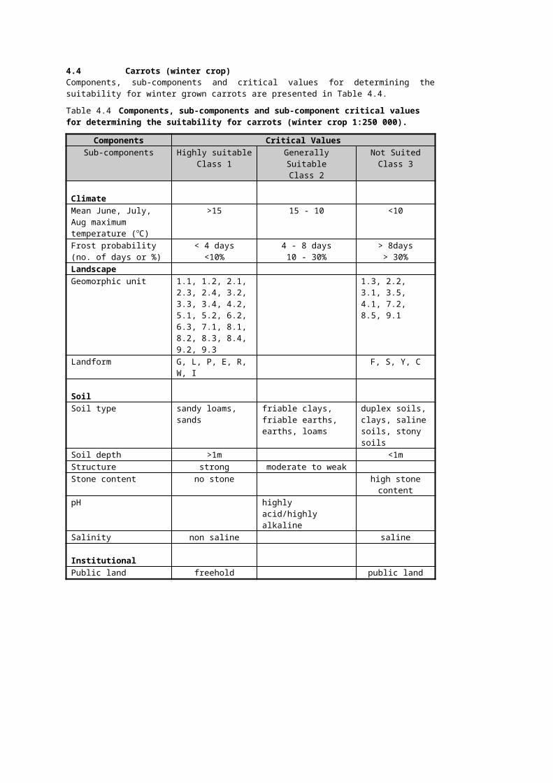
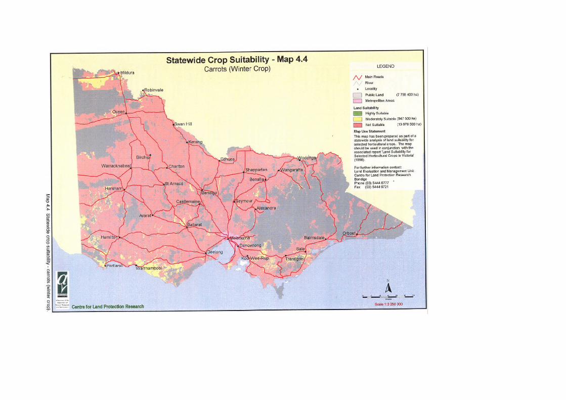
4.4 Carrots (winter crop)Components, sub-components and critical values for determining the suitability for winter grown carrots are presented in Table 4.4.
Table 4.4 Components, sub-components and sub-component critical values for determining the suitability for carrots (winter crop 1:250 000).
Components Critical ValuesSub-components Highly suitable
Class 1Generally Suitable
Class 2Not Suited
Class 3
ClimateMean June, July, Aug maximum temperature (oC)
>15 15 - 10 <10
Frost probability (no. of days or %)
< 4 days<10%
4 - 8 days10 - 30%
> 8days> 30%
LandscapeGeomorphic unit 1.1, 1.2, 2.1, 2.3,
2.4, 3.2, 3.3, 3.4, 4.2, 5.1, 5.2, 6.2, 6.3, 7.1, 8.1, 8.2, 8.3, 8.4, 9.2, 9.3
1.3, 2.2, 3.1, 3.5, 4.1, 7.2, 8.5, 9.1
Landform G, L, P, E, R, W, I F, S, Y, C
SoilSoil type sandy loams, sands friable clays, friable
earths, earths, loamsduplex soils, clays, saline soils, stony soils
Soil depth >1m <1mStructure strong moderate to weakStone content no stone high stone contentpH highly acid/highly
alkalineSalinity non saline saline
InstitutionalPublic land freehold public land

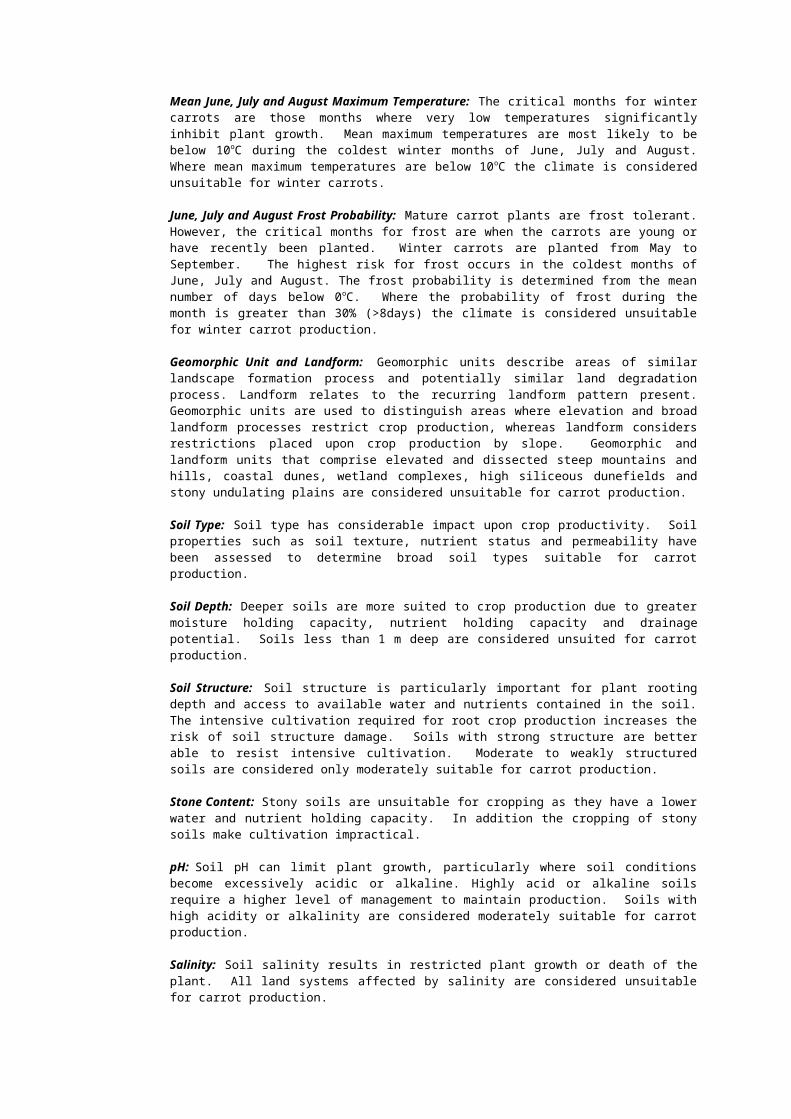
Mean June, July and August Maximum Temperature: The critical months for winter carrots are those months where very low temperatures significantly inhibit plant growth. Mean maximum temperatures are most likely to be below 10oC during the coldest winter months of June, July and August. Where mean maximum temperatures are below 10oC the climate is considered unsuitable for winter carrots.
June, July and August Frost Probability: Mature carrot plants are frost tolerant. However, the critical months for frost are when the carrots are young or have recently been planted. Winter carrots are planted from May to September. The highest risk for frost occurs in the coldest months of June, July and August. The frost probability is determined from the mean number of days below 0oC. Where the probability of frost during the month is greater than 30% (>8days) the climate is considered unsuitable for winter carrot production.
Geomorphic Unit and Landform: Geomorphic units describe areas of similar landscape formation process and potentially similar land degradation process. Landform relates to the recurring landform pattern present. Geomorphic units are used to distinguish areas where elevation and broad landform processes restrict crop production, whereas landform considers restrictions placed upon crop production by slope. Geomorphic and landform units that comprise elevated and dissected steep mountains and hills, coastal dunes, wetland complexes, high siliceous dunefields and stony undulating plains are considered unsuitable for carrot production.
Soil Type: Soil type has considerable impact upon crop productivity. Soil properties such as soil texture, nutrient status and permeability have been assessed to determine broad soil types suitable for carrot production.
Soil Depth: Deeper soils are more suited to crop production due to greater moisture holding capacity, nutrient holding capacity and drainage potential. Soils less than 1 m deep are considered unsuited for carrot production.
Soil Structure: Soil structure is particularly important for plant rooting depth and access to available water and nutrients contained in the soil. The intensive cultivation required for root crop production increases the risk of soil structure damage. Soils with strong structure are better able to resist intensive cultivation. Moderate to weakly structured soils are considered only moderately suitable for carrot production.
Stone Content: Stony soils are unsuitable for cropping as they have a lower water and nutrient holding capacity. In addition the cropping of stony soils make cultivation impractical.
pH: Soil pH can limit plant growth, particularly where soil conditions become excessively acidic or alkaline. Highly acid or alkaline soils require a higher level of management to maintain production. Soils with high acidity or alkalinity are considered moderately suitable for carrot production.
Salinity: Soil salinity results in restricted plant growth or death of the plant. All land systems affected by salinity are considered unsuitable for carrot production.
Public Land: Crop production is only applicable on private land.
Area Statement: The area statement below indicates the amount of land in hectares for each land suitability class across Victoria. The location of land in each land suitability class can be seen on the following land suitability map.
Area Statement: Highly suitable NilModerately suitable 947 500 haNot suitable 13 976 500 haPublic land 7 755 400 ha


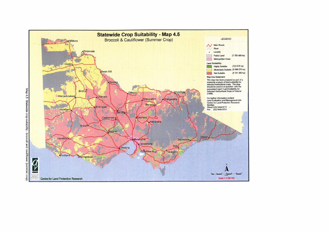
4.5 Broccoli and Cauliflower (summer crop)Components, sub-components and critical values for determining the suitability for summer grown broccoli and cauliflower are presented in Table 4.5.
Table 4.5 Components, sub-components and sub-component critical values for determining the suitability for broccoli and cauliflower (summer crop 1:250 000).
Components Critical ValuesSub-components Highly suitable
Class 1Generally Suitable
Class 2Not Suitable
Class 3
ClimateMean January maximum temperature (oC)
<28 28
LandscapeGeomorphic unit 1.1, 1.2, 2.1, 2.3,
2.4, 3.2, 3.3, 3.4, 4.1, 4.2, 5.1, 5.2, 6.2, 6.3, 7.1, 8.1, 8.2, 8.3, 8.4, 9.1, 9.2, 9.3
1.3, 2.2, 3.1, 3.5, 7.2, 8.5
Landform F, L, P, E, R, W, I G S, Y , C
SoilSoil type friable earths,
friable clays, earths, loams, sandy loams, sands
duplex soils, clays, saline soils, stony soils
Soil depth >1m <1mStructure Strong moderate to weakStone content no stone high stone contentpH highly acid/highly
alkalineSalinity non saline saline
InstitutionalPublic Land freehold land public land

Mean January Maximum Temperature: Broccoli and cauliflower have a summer growing season from 9 to 11 weeks. Both crops show yield penalties as a result of soil moisture deficits resulting from extended periods of hot weather over 35oC. Mean maximum January temperature is used as a surrogate indicator of the potential for days over 35oC. A mean maximum January temperature below 28oC infers relatively few days are above 35oC, and areas with this climate are considered suitable. Beyond a mean maximum January temperature of 28oC, the risk of a high number of days with temperatures higher than 35oC is high.
Geomorphic Unit and Landform: Geomorphic units describe areas of similar landscape formation process and potentially similar land degradation process. Landform relates to the recurring landform pattern present. Geomorphic units are used to distinguish areas where elevation and broad landform processes restrict crop production, whereas landform considers restrictions placed upon crop production by slope. Geomorphic and landform units that comprise elevated and dissected steep mountains and hills, coastal dunes, wetland complexes, high siliceous dunefields and stony undulating plains are considered unsuitable for broccoli and cauliflower production.
Soil Type: Soil type has considerable impact upon crop productivity. Soil properties such as soil texture, nutrient status and permeability have been assessed to determine broad soil types suitable for broccoli and cauliflower production.
Soil Depth: Deeper soils are more suited to crop production due to greater moisture holding capacity, nutrient holding capacity and drainage potential. Soils less than 1 m deep are considered unsuited for broccoli and cauliflower production.
Soil Structure: Soil structure is particularly important for plant rooting depth and access to available water and nutrients contained in the soil. Although the cultivation required for broccoli and cauliflower is less than that required for root crop production, significant soil tillage is required for seed bed establishment. Thus, the risk of soil structure damage under broccoli and cauliflower production is high. Soils with strong structure are better able to resist intensive cultivation. Moderate to weakly structured soils are considered only moderately suitable for broccoli and cauliflower production.
Stone Content: Stony soils are unsuitable for cropping as they have a lower water and nutrient holding capacity. In addition the cropping of stony soils make cultivation impractical.
pH: Soil pH can limit plant growth, particularly where soil conditions become excessively acidic or alkaline. Highly acid or highly alkaline soils require a higher level of management than other soils. Therefore, soils affected by high acidity or alkalinity are considered only moderately suitable for broccoli and cauliflower production.
Salinity: Soil salinity results in restricted plant growth or death of the plant. All land systems affected by salinity are considered unsuitable for broccoli and cauliflower production.
Public Land: Crop production is only applicable on private land.
Area Statement: The area statement below indicates the amount of land in hectares for each land suitability class across Victoria. The location of land in each land suitability class can be seen on the following land suitability map.
Area Statement: Highly suitable 723 575 haModerately suitable 5 099 075 haNot suitable 9 101 350 haPublic land 7 755 400 ha


4.6 Broccoli and cauliflower (winter crop)Components, sub-components and critical values for determining the suitability for winter grown broccoli and cauliflower are presented in Table 4.6.
Table 4.6 Components, sub-components and sub-component critical values for determining the suitability for broccoli and cauliflower (winter crop 1:250 000).
Components Critical ValuesSub-components Suitable
Class 1Generally Suitable
Class 2Not Suitable
Class 3
ClimateMean June, July, Aug maximum temperature (oC)
>15 15 - 10 <10
Frost probability (no. of days or %)
< 4 days<10%
4 - 8 days10 - 30%
> 8days> 30%
LandscapeGeomorphic unit 1.1, 1.2, 2.1, 2.3,
2.4, 3.2, 3.3, 3.4, 4.2, 5.1, 5.2, 6.2, 6.3, 7.1, 8.1, 8.2, 8.3, 8.4, 9.2, 9.3
1.3, 2.2, 3.1, 3.5, 4.1, 7.2, 8.5, 9.1
Landform G, L, P, E, R, W, I F, S, Y, C
SoilSoil type friable earths,
friable clays, earths, loams, sandy loams, sands
duplex soils, clays, saline soils, stony soils
Soil depth >1m <1mStructure Strong moderate to weakStone content no stone high stone contentpH highly acid/highly
alkalineSalinity non saline saline
InstitutionalPublic Land Freehold land public land
Mean June, July and August Maximum Temperature: The critical months for winter broccoli and cauliflower are those months where very low temperatures significantly inhibit plant growth. Mean maximum temperatures are most likely to be below 10oC during the coldest winter months of June, July and August. Where mean maximum temperatures are below 10oC the climate is considered unsuitable for winter broccoli and cauliflower.
June, July and August Frost Probability: Broccoli and cauliflower are susceptible to severe frosts. Less severe frost will damage the end quality of the crop but will not kill the crop. The highest risk for frost occurs in the coldest months of June, July and August. The frost probability is determined from the mean number of days below 0oC. Where the probability of frost during the month is greater than 30% (>8 days) the climate is considered unsuitable for winter crop production.
Geomorphic Unit and Landform: Geomorphic units describe areas of similar landscape formation process and potentially similar land degradation process. Landform relates to the recurring landform pattern present. Geomorphic units are used to distinguish areas where elevation and broad landform processes restrict crop production, whereas landform considers restrictions placed upon crop production by slope. Geomorphic and landform units that comprise elevated and dissected steep mountains and hills, coastal dunes, wetland complexes, high siliceous dunefields and stony undulating plains are considered unsuitable for broccoli and cauliflower production.

Soil Type: Soil type has considerable impact upon crop productivity. Soil properties such as soil texture, nutrient status and permeability have been assessed to determine broad soil types suitable for broccoli and cauliflower production.
Soil Depth: Deeper soils are more suited to crop production due to greater moisture holding capacity, nutrient holding capacity and drainage potential. Soils less than 1 m deep are considered unsuited for broccoli and cauliflower production.
Soil Structure: Soil structure is particularly important for plant rooting depth and access to available water and nutrients contained in the soil. Although the cultivation required for broccoli and cauliflower is less than that required for root crop production, significant soil tillage is required for seed bed establishment. Thus, the risk of soil structure damage under broccoli and cauliflower production is high. Soils with strong structure are better able to resist intensive cultivation. Moderate to weakly structured soils are considered only moderately suitable for broccoli and cauliflower production.
Stone Content: Stony soils are unsuitable for cropping as they have a lower water and nutrient holding capacity. In addition the cropping of stony soils make cultivation impractical.
pH: Soil pH can limit plant growth, particularly where soil conditions become excessively acidic or alkaline. Highly acid or highly alkaline soils require a higher level of management than other soils. Therefore, soils affected by high acidity or alkalinity are considered only moderately suitable for broccoli and cauliflower production.
Salinity: Soil salinity results in restricted plant growth or death of the plant. All land systems affected by salinity are considered unsuitable for broccoli and cauliflower production.
Public Land: Crop production is only applicable on private land.
Area Statement: The area statement below indicates the amount of land in hectares for each land suitability class across Victoria. The location of land in each land suitability class can be seen on the following land suitability map.
Area Statement: Highly suitable NilModerately suitable 947 500 haNot suitable 13 976 500 haPublic land 7 755 400 ha

4.7 LettuceComponents, sub-components and critical values for determining the suitability for summer grown lettuce are presented in Table 4.7.
Table 4.7 Components, sub-components and sub-component critical values for determining the suitability for lettuce (summer crop 1:250 000).
Components Critical ValuesSub-components Highly suitable
Class 1Generally Suitable
Class 2Not Suitable
Class 3Climate
Mean January maximum temperature (oC)
<28 28
Mean November Temperature (oC) >12 12-10 <10
Mean March Temperature (oC) >12 12-10 <10
Landscape
Geomorphic unit 1.1, 1.2, 2.1, 2.3, 2.4, 3.2, 3.3, 3.4, 4.1, 4.2, 5.1, 5.2, 6.2, 6.3, 7.1, 8.1, 8.2, 8.3, 8.4, 9.1, 9.2, 9.3
1.3, 2.2, 3.1, 3.5, 7.2, 8.5
Landform F, L, P, E, R, W, I G S, Y, C
Soil
Soil type friable clays, friable earths, peaty clays, sandy loams, sands
earths duplex soils, clays, stony soils, saline soils
Soil depth >1m <1m
Structure Strong moderate to weak
Stone content no stone high stone content
pH highly acid/highly alkaline
Salinity non saline saline
Public land Freehold land public land
Mean January Maximum Temperature: Lettuce is a summer crop that shows yield penalties as a result of soil moisture deficits or extended periods of hot weather over 35oC. Mean maximum January temperature is used as a surrogate indicator of the potential for days over 35oC. A mean maximum January temperature below 28oC infers relatively few days are above 35oC, and areas with this climate are considered suitable. Beyond a mean maximum January temperature of 28oC, the risk of a high number of days with temperatures higher than 35oC is high.
Mean November and March Temperatures: Lettuce is frost sensitive and requires a minimum growing period of between 45 and 65 days without severe frost. The summer growing season is assumed to be between November and March. Areas with mean November and March temperatures of greater than 10oC are assumed to have few or no severe frosts in those months, and in the months between November and March. Areas with greater than 5 months frost free (mean November and March temperatures of >12oC) are suitable for a number of varieties of lettuce.
Geomorphic Unit and Landform: Geomorphic units describe areas of similar landscape formation process and potentially similar land degradation process. Landform relates to the recurring landform pattern present. Geomorphic units are used to distinguish areas where elevation and broad landform processes restrict crop production, whereas landform considers restrictions placed upon crop production by slope. Geomorphic and landform units that comprise elevated and dissected steep mountains and hills, coastal dunes, wetland complexes, high siliceous dunefields and stony undulating plains are considered unsuitable for lettuce production.
Soil Type: Soil type has considerable impact upon crop productivity. Soil properties such as soil texture, nutrient status and permeability have been assessed to determine broad soil types suitable for lettuce production.
Soil Depth: Deeper soils are more suited to crop production due to greater moisture holding capacity, nutrient holding capacity and drainage potential. Soils less than 1 m deep are considered unsuited for lettuce production.
Soil Structure: Soil structure is particularly important for plant rooting depth and access to available water and nutrients contained in the soil. Although the cultivation required for lettuce is less than that required for root crop production, significant soil tillage is required for seed bed establishment. Thus, the risk of soil structure damage under lettuce production is high. Soils with strong structure are better able to resist intensive cultivation. Moderate to weakly structured soils are considered only moderately suitable for lettuce production.
Stone Content: Stony soils are unsuitable for cropping as they have a lower water and nutrient holding capacity. In addition the cropping of stony soils make cultivation impractical.
pH: Soil pH can limit plant growth, particularly where soil conditions become excessively acidic or alkaline. Highly acid or highly alkaline soils require a higher level of management than other soils. Therefore soils with high or low pH are less suited to lettuce production.
Salinity: Soil salinity results in restricted plant growth or death of the plant. All land systems affected by salinity are considered unsuitable for lettuce production.
Public Land: Crop production is only applicable on private land.
Area Statement: The area statement below indicates the amount of land in hectares for each land suitability class across Victoria. The location of land in each land suitability class can be seen on the following land suitability map.
Area Statement: Highly suitable 612 000 haModerately suitable 3 279 450 haNot suitable 11 032 550 haPublic land 7 755 400 ha


4.8 Lettuce (winter crop)Components, sub-components and critical values for determining the suitability for winter grown lettuce are presented in Table 4.8.
Table 4.8 Components, sub-components and sub-component critical values for determining the suitability for lettuce (winter crop 1:250 000).
Components Critical ValuesSub-components Highly suitable
Class 1Generally Suitable
Class 2Not Suitable
Class 3
ClimateMean June, July, Aug maximum temperature (oC)
>15 15 - 10 <10
Frost probability (no. of days or %)
<1 days<3%
1 - 4 days3 -10%
>4days> 10%
LandscapeGeomorphic unit 1.1, 1.2, 2.1, 2.3, 2.4,
3.2, 3.3, 3.4, 4.2, 5.1, 5.2, 6.2, 6.3, 7.1, 8.1, 8.2, 8.3, 8.4, 9.2, 9.3
1.3, 2.2, 3.1, 3.5, 4.1, 7.2, 8.5, 9.1
Landform G, L, P, E, R, W, I F, S, Y, CSoilSoil type Friable clays, friable
earths, peaty clays, sandy loams, sands
earths duplex soils, clays, stony soils, saline soils
Soil depth >1m <1mStructure strong moderate to weakStone content no stone high stone contentpH highly acid/highly
alkalineSalinity non saline saline
InstitutionalPublic land Freehold land public land
Mean June, July and August Maximum Temperature: The critical months for winter lettuce are those months where very low temperatures significantly inhibit plant growth. Mean maximum temperatures are most likely to be below 10oC during the coldest winter months of June, July and August. Where mean maximum temperatures are below 10oC the climate is considered unsuitable for winter lettuce.
June, July and August Frost Probability: Very severe frost below -3oC will kill a lettuce crop. Less severe frost will damage the end quality of the crop but will not kill the crop. The highest risk for frost occurs in the coldest months of June, July and August. The frost probability is determined from the mean number of days below 0oC . Where the probability of frost during the month is greater than 30% (>4 days) the climate is considered unsuitable for winter crop production.
Geomorphic Unit and Landform: Geomorphic units describe areas of similar landscape formation process and potentially similar land degradation process. Landform relates to the recurring landform pattern present. Geomorphic units are used to distinguish areas where elevation and broad landform processes restrict crop production, whereas landform considers restrictions placed upon crop production by slope. Geomorphic and landform units that comprise elevated and dissected steep mountains and hills, coastal dunes, wetland complexes, high siliceous dunefields and stony undulating plains are considered unsuitable for lettuce production.
Soil Type: Soil type has considerable impact upon crop productivity. Soil properties such as soil texture, nutrient status and permeability have been assessed to determine broad soil types suitable for lettuce production.
Soil Depth: Deeper soils are more suited to crop production due to greater moisture holding capacity, nutrient holding capacity and drainage potential. Soils less than 1 m deep are considered unsuited for lettuce production.
Soil Structure: Soil structure is particularly important for plant rooting depth and access to available water and nutrients contained in the soil. Although the cultivation required for lettuce is less than that required for root crop production, significant soil tillage is required for seed bed establishment. Thus, the risk of soil structure damage under lettuce production is high. Soils with strong structure are better able to resist intensive cultivation. Moderate to weakly structured soils are considered only moderately suitable for lettuce production.
Stone Content: Stony soils are unsuitable for cropping as they have a lower water and nutrient holding capacity. In addition the cropping of stony soils make cultivation impractical.
pH: Soil pH can limit plant growth, particularly where soil conditions become excessively acidic or alkaline. Highly acid or highly alkaline soils require a higher level of management than other soils. Therefore soils with high or low pH are less suited to lettuce production.
Salinity: Soil salinity results in restricted plant growth or death of the plant. All land systems affected by salinity are considered unsuitable for lettuce production.
Public Land: Crop production is only applicable on private land.
Area Statement: The area statement below indicates the amount of land in hectares for each land suitability class across Victoria. The location of land in each land suitability class can be seen on the following land suitability map.
Area Statement: Highly suitable 875 haModerately suitable 731 550 haNot suitable 14 191 575 haPublic land 7 755 400 ha


4.9 Asparagus (summer crop)Components, sub-components and critical values for determining the suitability for summer grown asparagus are presented in Table 4.9.
Table 4.9 Components, sub-components and sub-component critical values for determining the suitability for asparagus (summer crop 1:250 000).
Components Critical Values
Sub-components Highly suitableClass 1
Generally SuitableClass 2
Not SuitableClass 3
Climate
Mean January maximum temperature (oC)
<32 32
Mean November Temperature (oC)
>15 15-13 <13
Mean March Temperature (oC)
>15 15-13 <13
Landscape
Geomorphic unit 1.1, 1.2, 2.1, 2.3, 2.4, 3.2, 3.3, 3.4, 4.1, 4.2, 5.1, 5.2, 6.2, 6.3, 7.1, 8.1, 8.2, 8.3, 8.4, 9.1, 9.2, 9.3
1.3, 2.2, 3.1, 3.5, 7.2, 8.5
Landform F, G, L, P, E, R, W, I G S, Y, C
Soil
Soil type Friable clays, friable earths, peaty clays, sandy loams, sands
earths, loams duplex soils, clays, stony soils, saline soils
Soil depth >1m <1m
Structure strong moderate to weak
Stone content no stone high stone content
pH highly acid/highly alkaline
Salinity non saline saline
Institutional
Public land Freehold land public land

Mean January Maximum Temperature: Summer asparagus crops show yield penalties as a result of soil moisture deficits resulting from extended periods of hot weather over 40oC. Mean maximum January temperature is used as a surrogate indicator of the potential for days over 40oC. A mean maximum January temperature below 32oC infers relatively few days are above 40oC, and areas with this climate are considered suitable. Beyond a mean maximum January temperature of 32oC, the risk of a high number of days with temperatures higher than 40oC is high.
Mean November and March Temperatures: Asparagus is sensitive to cool temperatures and susceptible to frost damage. The summer growing season is assumed to be between November and March. Areas with mean November and March temperatures of less than 13oC are assumed to have restrictions on plant growth. In areas, where mean temperatures are greater than 13oC, plant growth will show no yield penalties.
Geomorphic Unit and Landform: Geomorphic units describe areas of similar landscape formation process and potentially similar land degradation process. Landform relates to the recurring landform pattern present. Geomorphic units are used to distinguish areas where, elevation and broad landform processes restrict crop production, whereas landform considers restrictions placed upon crop production by slope. Geomorphic and landform units that comprise elevated and dissected steep mountains and hills, coastal dunes, wetland complexes, high siliceous dunefields and stony undulating plains are considered unsuitable for asparagus production.
Soil Type: Soil type has considerable impact upon crop productivity. Soil properties such as soil texture, nutrient status and permeability have been assessed to determine broad soil types suitable for asparagus production.
Soil Depth: Deeper soils are more suited to crop production due to greater moisture holding capacity, nutrient holding capacity and drainage potential. Soils less than 1 m deep are considered unsuited for asparagus production.
Soil Structure: Soil structure is particularly important for plant rooting depth and access to available water and nutrients contained in the soil. The intensive cultivation required for root crop production increases the risk of soil structure damage. Soils with strong structure are better able to resist intensive cultivation. Moderate to weakly structured soils are considered only moderately suitable for asparagus production.
Stone Content: Stony soils are unsuitable for cropping as they have a lower water and nutrient holding capacity. In addition the cropping of stony soils make cultivation impractical.
pH: Soil pH can limit plant growth, particularly where soil conditions become excessively acidic or alkaline. Highly acid or highly alkaline soils require a higher level of management than other soils. Therefore, these soils are less suited to asparagus production.
Salinity: Soil salinity results in restricted plant growth or death of the plant. All land systems affected by salinity are considered unsuitable for asparagus production.
Public Land: Crop production is only applicable on private land.
Area Statement: The area statement below indicates the amount of land in hectares for each land suitability class across Victoria. The location of land in each land suitability class can be seen on the following land suitability map.
Area Statement: Highly suitable 828,100 haModerately suitable 3 456 175 haNot suitable 10 639 725 haPublic land 7 755 400 ha


4.10 Sweet Corn (summer crop)Components, sub-components and critical values for determining the suitability for summer grown sweet corn are presented in Table 4.10.
Table 4.10 Components, sub-components and sub-component critical values for determining the suitability for sweet corn (summer crop 1:250 000).
Components Critical ValuesSub-components Highly suitable
Class 1Generally Suitable
Class 2Not Suitable
Class 3
ClimateMean January maximum temperature (oC)
<35 35
Mean November Temperature (oC)
>15 15 - 10 <10
Mean March Temperature (oC)
>15 15 – 14 <14
LandscapeGeomorphic unit 1.1, 1.2, 2.1, 2.3,
2.4, 3.2, 3.3, 3.4, 4.1, 4.2, 6.2, 6.3, 7.1, 8.1, 8.2, 8.3, 8.4, 9.1, 9.2, 9.3
5.1, 5.2 1.3, 2.2, 3.1, 3.5, 7.2, 8.5
Landform F, L, P, E, R, W, I G S, Y, C
SoilSoil type Friable earths,
friable clays, loams, sandy loams
duplex soils, clays, earths, sands, calcareous soils
saline soils, stony soils
Soil depth >1m <1mSalinity non saline saline
InstitutionalPublic land freehold land public land

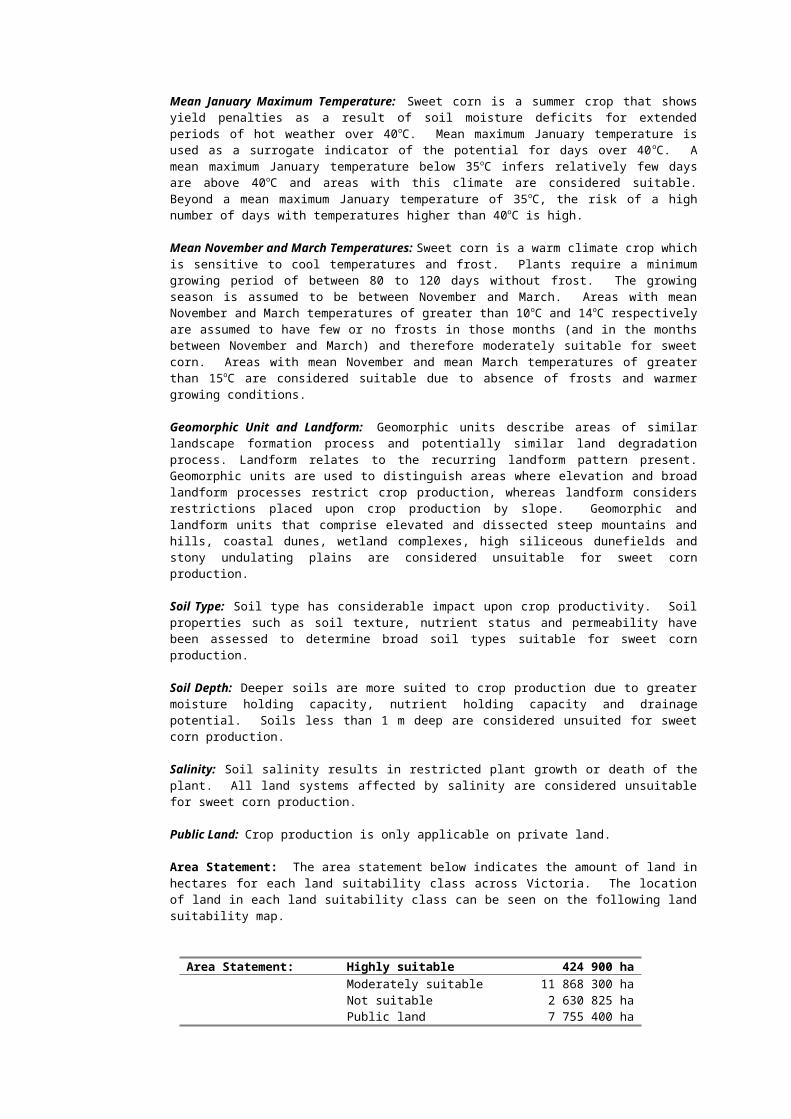
Mean January Maximum Temperature: Sweet corn is a summer crop that shows yield penalties as a result of soil moisture deficits for extended periods of hot weather over 40 oC. Mean maximum January temperature is used as a surrogate indicator of the potential for days over 40oC. A mean maximum January temperature below 35oC infers relatively few days are above 40oC and areas with this climate are considered suitable. Beyond a mean maximum January temperature of 35oC, the risk of a high number of days with temperatures higher than 40oC is high.
Mean November and March Temperatures: Sweet corn is a warm climate crop which is sensitive to cool temperatures and frost. Plants require a minimum growing period of between 80 to 120 days without frost. The growing season is assumed to be between November and March. Areas with mean November and March temperatures of greater than 10oC and 14oC respectively are assumed to have few or no frosts in those months (and in the months between November and March) and therefore moderately suitable for sweet corn. Areas with mean November and mean March temperatures of greater than 15oC are considered suitable due to absence of frosts and warmer growing conditions.
Geomorphic Unit and Landform: Geomorphic units describe areas of similar landscape formation process and potentially similar land degradation process. Landform relates to the recurring landform pattern present. Geomorphic units are used to distinguish areas where elevation and broad landform processes restrict crop production, whereas landform considers restrictions placed upon crop production by slope. Geomorphic and landform units that comprise elevated and dissected steep mountains and hills, coastal dunes, wetland complexes, high siliceous dunefields and stony undulating plains are considered unsuitable for sweet corn production.
Soil Type: Soil type has considerable impact upon crop productivity. Soil properties such as soil texture, nutrient status and permeability have been assessed to determine broad soil types suitable for sweet corn production.
Soil Depth: Deeper soils are more suited to crop production due to greater moisture holding capacity, nutrient holding capacity and drainage potential. Soils less than 1 m deep are considered unsuited for sweet corn production.
Salinity: Soil salinity results in restricted plant growth or death of the plant. All land systems affected by salinity are considered unsuitable for sweet corn production.
Public Land: Crop production is only applicable on private land.
Area Statement: The area statement below indicates the amount of land in hectares for each land suitability class across Victoria. The location of land in each land suitability class can be seen on the following land suitability map.
Area Statement: Highly suitable 424 900 haModerately suitable 11 868 300 haNot suitable 2 630 825 haPublic land 7 755 400 ha


4.11 Fresh Market Tomatoes (summer crop)Components, sub-components and critical values for determining the suitability for summer grown fresh market tomatoes are presented in Table 4.11.
Table 4.11 Components, sub-components and sub-component critical values for determining the suitability for fresh market tomatoes (summer crop 1:250 000).
Components Critical ValuesSub-components Highly suitable
Class 1Generally Suitable
Class 2Not Suitable
Class 3
ClimateMean January Temperature (oC)
<35 35 -
Mean November Temperature (oC)
>15 15 - 10 <10
Mean March Temperature (oC)
>15 15 - 10 <10
LandscapeGeomorphic unit 1.1, 1.2, 2.1, 2.3, 2.4,
3.2, 3.3, 3.4, 4.1, 4.2, 6.2, 6.3, 7.1, 8.1, 8.2, 8.3, 8.4, 9.1, 9.2, 9.3
5.1, 5.2 1.3, 2.2, 3.1, 3.5, 7.2, 8.5
Landform F, G, L, P, E, R, W, I S, Y, C
SoilSoil type friable earths, earths,
friable clays, loams, sandy loams
sands, earths, clays, calcareous soils, duplex soils
saline soils, stony soils
Soil depth >1m <1mStone content no stone high stone contentSalinity non saline saline
InstitutionalPublic land freehold land public land

Mean January, November and March Temperatures: Tomatoes are a warm climate crop. Temperature is the main factor in determining plant growth and development. Where mean maximum January temperatures exceed 40oC growth rates decline rapidly. The optimal mean maximum January temperature range is below 35 oC.
Mean November and March Temperatures: Tomatoes are a summer crop which is sensitive to cool temperatures and frost. Plants require a minimum growing period of 130 days without frost. The growing season is assumed to be between November and March. Areas with mean November and March temperatures of greater than 10oC are assumed to have few or no frosts in those months, (and in the months between November and March), and are moderately suitable for tomato production. Areas with mean November and mean March temperatures of greater than 15oC are considered suitable due to absence of frosts and warmer growing conditions.
Geomorphic Unit and Landform: Geomorphic units describe areas of similar landscape formation process and potentially similar land degradation process. Landform relates to the recurring landform pattern present. Geomorphic units are used to distinguish areas where, elevation and broad landform processes restrict crop production, whereas landform considers restrictions placed upon crop production by slope. Geomorphic and landform units that comprise elevated and dissected steep mountains and hills, coastal dunes, wetland complexes, high siliceous dunefields and stony undulating plains are considered unsuitable for tomato production.
Soil Type: Soil type has considerable impact upon crop productivity. Soil properties such as soil texture, nutrient status and permeability have been assessed to determine broad soil types suitable for tomato production.
Soil Depth: Deeper soils are more suited to crop production due to greater moisture holding capacity, nutrient holding capacity and drainage potential. Soils less than 1 m deep are considered unsuited for tomato production.
Stone Content: Stony soils are unsuitable for cropping as they have a lower water and nutrient holding capacity. In addition the cropping of stony soils make cultivation impractical.
Salinity: Soil salinity results in restricted plant growth or death of the plant. All land systems affected by salinity are considered unsuitable for tomato production.
Public Land: Crop production is only applicable on private land.
Area Statement: The area statement below indicates the amount of land in hectares for each land suitability class across Victoria. The location of land in each land suitability class can be seen on the following land suitability map.
Area Statement: Highly suitable 414 850 haModerately suitable 11 878 075 haNot suitable 2 631 100 haPublic land 7 755 400 ha


5 DATA SOURCESMean Monthly TemperatureMean monthly temperature was calculated from the average of mean monthly minimum and maximum temperatures. Mean monthly minimum and maximum temperatures were estimated using a 500 m grid cell from a 1:250 000 digital elevation model and the ESOCLIM software.
Geomorphic UnitDerived from the Statewide Land Systems (1:250 000) (Rowan, 1990) data set. Codes and descriptions for landforms are presented in Table 5.1.
Table 5.1 Geomorphic Unit CodesGeomorphic Region Geomorphic Zone Geomorphic
Unit CodeGeomorphic Unit
1.1 Dissected UplandsEast Victorian Uplands 1.2 Dissected Plateaux (Wellington
Uplands)1.3 High plains (Dargo, Bogong, etc.)
CENTRAL VICTORIAN UPLANDS
2.1 Dissected Uplands (Midlands, etc.)
2.2 Prominent Ridges (Grampians)West Victorian Uplands 2.3 Dissected Tablelands (Dundas
Tableland)2.4 Dissected Tablelands (Merino
Tableland)3.1 Dissected Fault Blocks (Otway
Range)3.2 Moderately Dissected Block
(Barrabool Hills)SOUTH VICTORIAN UPLANDS
3.3 Moderately Dissected Ridge (Mornington Peninsula)
3.4 Dissected Fault Block (South Gippsland Ranges)
3.5 Dissected Outlier (Wilson's Promontory)
Riverine Plain 4.1 Present Floodplain (Murray Valley)4.2 Older Alluvial Plain (Shepparton)
Mallee Dune field 5.1 Low Calcareous Dunes (Ouyen)MURRAY BASIN PLAINS
5.2 High Siliceous Dunes (Big Desert/Sunset)
6.1 Clay Plains (Nhill)Wimmera Plains 6.2 Ridges and Flats (Goroke)
6.3 Low Siliceous Dunes (Little Desert)WEST VICTORIAN VOLCANIC PLAINS
7.1 Undulating Plains (Western District)
7.2 Stony Undulating Plains (Western District)
8.1 Ridges and Flats (Follet)8.2 Dissected Plains (Port Campbell)
SOUTH VICTORIAN COASTAL PLAINS
8.3 Sand and Clay Plains (Moorabbin)
8.4 Fans and Terraces (Western Port)8.5 Barrier complexes (Discovery
Bay/Gippsland Lakes)9.1 Present floodplains (Gippsland)
SOUTH VICTORIAN RIVERINE PLAINS
9.2 Intermediate floodplains (Gippsland)
9.3 High terraces and fans (Gippsland)

LandformDerived from the Statewide Land Systems (1:250 000) (Rowan, 1990) data set. Codes and descriptions for landform are presented in Table 5.2.Table 5.2 Landform codes and descriptions (Rowan, 1990)
Code DescriptionC Coastal duneE East-west duneF Present floodplainG Gentle to moderate hillI Irregular duneL LunetteP Plain above sea-levelR Stranded beach ridge, usually trending NNW-SSES Steep mountain and hillW Weakly elongated duneY Gypseous dune
Soil TypeSoil types are taken from the Statewide Land Systems (1:250 000) (Rowan, 1990) data set. A full list of the 77 soil types is presented in Appendix 1. To simplify the analysis, key soil types were identified and used to rate the soils according to the three suitability classes. The key soil types are as follows;
friable earths
friable clays
earths
loams
sandy loams
sands
duplex soils
clays
saline soils
stony soils

Where the key soil type matched with part of the soil type description, a match would be made i.e. key soil type ‘clays’ matches with soil type ‘yellow clays’. In order to identify the most limiting soil types for each crop, the matching of key soil types with soil types commenced with those considered Not Suitable followed by Generally Suitable and finally Suitable.
Where a number of soil types were recorded within one land system, the soil type would be classed as Highly Suitable only when all recorded soil types matched those listed in the Highly Suitable column of the respective rating table. If there was not a match, the lowest rating class (Generally Suitable or Not Suitable) matching a recorded soil type would be used.
Soil Depth
Derived from the Statewide Land Systems (1:250 000) (Rowan, 1990) data set. Two classes were used, soils greater than 1 m depth and soils shallower than 1 m depth.
Structure
The structure of the soil was inferred from the soil type. Two classes were used; strong, and moderate to weak (Appendix 1). Strong soil structures are normally suited to more intensive agricultural pursuits that require significant cultivation. Moderate to weak soil structures are more likely to have, or be susceptible to, soil structure decline.
Stone Content
Soil stone content was inferred from the soil type and classed as to whether there would be a significant limitation to cultivation or root growth. Two classes were used, no stone and high stone content (Appendix 1).
pH
Soil pH was inferred from the soil type and classed as to whether there would be a significant limitation to plant growth due to the pH being too high (alkaline) or too low (acid). Two classes were used, highly acid and highly alkaline (Appendix 1).
SalinitySalinity was inferred from the soil type and classed as to whether there would be a significant limitation to plant growth. Two classes were used, saline and non-saline (Appendix 1).
FrostThe frost surface layers have been derived from Bureau of Meteorology data – days less than 0oC. This point site data has been used with a 250m resolution digital elevation model (dem) to interpolate the number of days less than 0oC across Victoria using the anusplin program. Anusplin software has been developed by the Australian National University.
Public LandPublic land was taken from the Department of Natural Resources and Environment’s corporate spatial data library LANDMMT100 land management layer.
WaterGroundwater quality was sourced from the Victorian Groundwater Beneficial Use Map Series (DCNR, 1995). Three classes of water quality are presented, less than 1000 mg/L TDS (high quality water), 1000 – 3500 mg/L TDS (medium quality water) and greater than 3500 mg/L TDS (poor quality water).The potential availability of surface water is based on the location of current irrigation systems.

6 DATA LIMITATIONSThe mapping provided is based on 1:250 000 scale land systems information that is suitable for broadscale planning purposes rather than at the paddock level investigation. Prior to investment in the horticulture industry, the authors strongly advise that further detailed analysis is carried out by an organisation with proven, relevant skills, at the paddock level to further identify limitations and provide detailed management options.Data used from the Statewide Land Systems has certain limitations that need to be borne in mind if spurious or erroneous results are to be avoided. The major constraints are:
precision of boundaries,
scale,
quality and evenness of the base data, and
detail of land system descriptions.
This means that the sub-components, particularly soil information, can provide only a general guide to the condition of the land within a land system.Qualitative assessments have been made with respect to a number of soil parameters (stone content, salinity, pH and structure) based on expert knowledge.
7 REFERENCESDCNR (1995) Victorian Groundwater Beneficial Use Map Series, North Western Victoria
Water Table Aquifers, South Western Victoria Water table Aquifers, Eastern Victoria Water Table Aquifers. Department of Natural Resources and Environment, Melbourne.
McDonald, R.C., Isbell, R.F., Speight, J.G., Walker, J. and Hopkins, M.S. (1990) Australian soil and land survey - field handbook. Inkata Press, Adelaide.
Rowan, J. (1990) Land Systems of Victoria. Land Conservation Council and Land Protection Division, Department of Conservation and Environment.

8 ACKNOWLEDGEMENTSThe authors would like to acknowledge the assistance of the following Agriculture Victoria Staff, in particular David Morey, for their assistance in the development and review of the land suitability assessment tables and associated land suitability maps.
Russell Sully (Agriculture Victoria, Knoxfield)
Wendy Morgan (Agriculture Victoria, Knoxfield)
Kan Moorthy (Agriculture Victoria, Knoxfield)
Andrew Henderson (Agriculture Victoria, Knoxfield)
David Eagling (Agriculture Victoria, Knoxfield)
David O'Donnell (Agriculture Victoria, Knoxfield)
Steven Moore (DNRE, Geelong)
Rob Dimsey (DNRE, Bairnsdale)
Bill Ashcroft (Agriculture Victoria, Tatura)

APPENDIX 1.Soil types and inferred limitations for structure, stone, high pH, low pH and salinity. No classification indicates that no limitation exists.
Soil Type (Rowan 1990) Structure1 Stone2 pH (low)3 pH (high)4 Salinity5
Black friable clays
Black sands low
Brown calcareous clays high
Brown calcareous earths moderate to weak
high
Brown clays moderate to weak
Brown coarse sands
Brown duplex soils moderate to weak
Brown earths low
Brown friable earths
Brown loams
Calcareous clays moderate to weak
high
Calcareous earths high
Calcareous sands high
Clays moderate to weak
Coarse sands moderate to weak
high low
Dark clays moderate to weak
Dark earths moderate to weak
Duplex soils moderate to weak
Earths moderate to weak
Friable earths
Friable red earths
Appendix 1 continued next page

APPENDIX 1 (continued).Soil types and inferred limitations for structure, stone, high pH, low pH and salinity. No classification indicates that no limitation exists.
Gravels moderate to weak
high
Grey clays moderate to weak
Grey earths moderate to weak
Grey gypseous clays moderate to weak
high
Grey loams moderate to weak
Grey sands low
Loams
Mottled duplex soils moderate to weak
Mottled earths moderate to weak
Organic loams
Pale calcareous sands high
Pale sands low
Peats
Peaty clays
Peaty sands
Red brown clays moderate to weak
Red calcareous earths moderate to weak
high
Red clays moderate to weak
Red duplex soils moderate to weak
Red earths moderate to weak
low
Red friable clays moderate to weak
Appendix 1 continued next page

APPENDIX 1 (continued).Soil types and inferred limitations for structure, stone, high pH, low pH and salinity. No classification indicates that no limitation exists.
Soil Type (Rowan 1990) Structure1 Stone2 pH (low)3 pH (high)4 Salinity5
Red friable earths
Red loams moderate to weak
Red sands low high
Red shallow earths moderate to weak
Reddish brown earths moderate to weak
Reddish yellow earths moderate to weak
Reddish yellow sands low
Saline clays moderate to weak
high Saline
Saline loams high Saline
Saline soils high Saline
Sands low
Sandy earths moderate to weak
Sandy loams
Sandy mottled duplex soils
moderate to weak
Sandy red duplex soils moderate to weak
Sandy yellow duplex soils moderate to weak
low
Shallow loams moderate to weak
low
Shallow sands moderate to weak
Shallow stony clays moderate to weak
high low
Shallow stony earths moderate to weak
high low
Appendix 1 continued next page
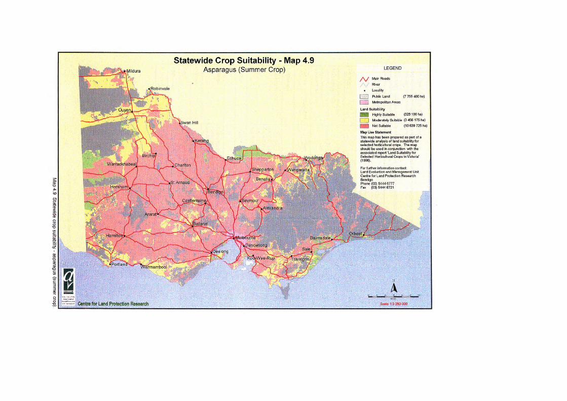
APPENDIX 1 (continued).Soil types and inferred limitations for structure, stone, high pH, low pH and salinity. No classification indicates that no limitation exists.Shallow stony loams highShallow stony sands highStony earths moderate to
weakhigh
Stony friable earths moderate to weak
high low
Stony loams highStony mottled duplex soils
moderate to weak
high
Stony red duplex soils moderate to weak
high
Stony red earths moderate to weak
high low
Stony yellow earths moderate to weak
high
Yellow clays moderate to weak
Yellow duplex soils moderate to weak
Yellow earths moderate to weak
low
Yellow sands lowYellowish brown earths moderate to
weakYellowish duplex soils moderate to
weak
1 No listing indicates strong structure2 No listing indicates no significant stone3 No listing indicates no significant acid soil problem4 No listing indicates no significant alkaline soil problem5 No listing indicates no significant salinity problem