vOLUME2-fULL
254
Volume: II Comprehensive CAT Plan of Satluj River Basin REPORT ON COMPREHENSIVE CATCHMENT AREA TREATMENT PLAN FOR SATLUJ RIVER BASIN IN HIMACHAL PRADESH Volume II : Landslides-Descriptions and Mitigation with Estimates Section Chapter Content Page No 1 Introduction 1-6 2 Endangering landslides 7-74 3 Landslides-Descriptions and Mitigation with costing 75-175 4 Landslides estimates 176-212 5 1 Nala With Heavy Debris Flow 213-251 2 Costing 252-253
-
Upload
shilpa-gupta -
Category
Documents
-
view
224 -
download
2
description
vOLUME2-fULL
Transcript of vOLUME2-fULL

Volume: II
Comprehensive CAT Plan of Satluj River Basin
REPORT ON COMPREHENSIVE CATCHMENT AREA TREATMENT PLAN FOR SATLUJ RIVER
BASIN IN HIMACHAL PRADESH
Volume II : Landslides-Descriptions and Mitigation with Estimates
Section Chapter Content Page No
1 Introduction 1-6
2 Endangering landslides 7-74
3 Landslides-Descriptions and Mitigation with costing 75-175
4 Landslides estimates 176-212
5 1 Nala With Heavy Debris Flow 213-251
2 Costing 252-253

Volume: II Section: 1 Page No: 1
Comprehensive CAT Plan of Satluj River Basin
Section 1:
Introduction
Disasters in Context of Himachal Pradesh*1:
Geologically the Himalayas are considered to be the youngest mountain chain in the
world and are still in the building phase. Himalayas were formed about 45 million years
ago, when the Indian Plate collided with Eurasian Plate at the rate of 15cm per year. The
Indian Plate is still moving northwards today into the Eurasian Plate at the rate of about
2cm per year. As a result of this the Himalayas are rising at the rate of about 5mm per
year. This means that the Himalayas are still geologically active. When two plates move
sideways against each other (at transform plate boundary), there is tremendous friction,
which makes the movement jerky. The plates slip, then stick, as the friction and
pressure build up to incredible levels. When the pressure is released suddenly, and the
plates jerk apart, the result is an occurrence of an earthquake. For this reason,
earthquakes are frequent in the entire Himalayan region.
The state of Himachal Pradesh is in the Northwestern Himalayas. It is environmentally
fragile and ecologically vulnerable. Natural hazards are a matter of immediate concern to
the state of Himachal Pradesh as every year the state experiences the fury of nature in
various forms-like earthquakes, cloudburst, flash floods, landslides, snow avalanches
droughts etc. The fragile ecology of the mountain state coupled with large variations in
physio-climatic conditions has rendered it vulnerable to the vagaries of nature. The
incidence of cloudbursts in the last few years is indicative of greater impending disasters
ito come in future. landslides and snow avalanches continue to inflict widespread harm
and damage to human life as well as property. The roads that are the state’s lifeline are
repeatedly damaged, blocked or washed away by one or other acts of nature.
The state as a whole is vulnerable to different kinds of disasters, natural as well as man-
made in nature. The major natural disasters or hazards which the state has experienced
over the years are as follows:
Earthquakes Landslides
Flash floods Cloud bursts
Avalanches Hailstorms/Droughts
EARTHQUAKES
Himachal Pradesh is in very sensitive seismic zones. It falls in zone V and IV as per the
Seismic Zoning Map of India. ( Ref : IS: 1893-1984 Fourth Revision. Earlier there were
five seismic zones which have been further narrowed to four zones now. According to the
Foreword to the seismic code IS: 1983-1984, the general basis of zoning is as follows:
Zone V: Covers the areas liable to seismic intensity IX and above on Modified Mercalli
Intensity Scale. This is the most severe seismic zone and is referred to as the
Very
High Damage Risk Zone.
Zone IV: Gives the area liable to MM VIII. This zone is second in severity to zone V. This is
referred to as the High Damage Risk Zone.
Zone III: The associated intensity is MM VII. This is termed the Moderate Damage Risk
Zone.
Zone II: The probable intensity is MM VI. This zone is referred to as the Low Damage Risk
Zone.
1 Natural Disasters and Climate Change - Himachal SoE

Volume: II Section: 1 Page No: 2
Comprehensive CAT Plan of Satluj River Basin
From the perusal of seismic zoning map of Himachal Pradesh (Fig.II) it is seen that 32 %
of the total geographical area is prone to the severest seismic risks as it falls into the
Very High Damage Risk Zone V. It was subjected in 1905 to one of the most giant
earthquakes of the recorded seismic history of India having a magnitude of 8.0 on the
openended Richter Scale in which 20,000 people lost their lives, the towns of Kangra and
Dharamshala were razed to the ground and no government functionary was left alive to
report the happening to the higher authorities. It shook an area of more than 416000
km2 in and around the present Himachal Pradesh. A maximum Intensity X on Rossiforel
Scale was observed in the epicentral area which, when interpreted on the new current
Modified Mercalli Scale, would be between X and XI. There have been 250 earthquakes
of magnitude 4.0 and more including more than sixty earthquakes with magnitude 5.0 or
more, which rocked the state of H.P. and adjoining areas of J&K and Uttranchal Pradesh
in the last 90 years. The Kinnaur earthquake of January 19, 1975 (M=6.7) and the
Dharamshala earthquake of April 26,1986 (M=5.7) are well recorded in respect of
damages caused and loses incurred. A list of earthquakes of M=4.0 or more is given in
Table II which had their epicenters either within or close to the state boundary.
Earthquakes having magnitude 4 or more on the Richter Scale in Himachal Pradesh
during the last 200 years.
S.No Year Month Day Magnitude Coordinates Tentative location
1 1809 - 5.5 30042’00” Near Labrang
780 30’00” (Distt.Kinnaur)
2 1827 9 5.5 32030’00” Near Dalhousie
76000’00” (Distt. Chamba)
3 1856 4 7 5 31000’00” Near Ranhog
77000’00” (Distt.Solan)
4 1858 8 11 5 3107’12” Shimla
77010’12” (Distt.Shimla)
5 1865 4 11 — Shimla region
6 1905 4 4 8 32018’00” Karari Dal
76015’00” (Distt.Kangra)
7 1906 2 28 7 32000’00” Near Karshing
770 00’00” (Distt.Kullu)
8 1930 5 11 5.5 31042’00” Shila Kiepr
77000’00” (Distt. Mandi)
9 1940 4 7 — 31 05 Near kali Hatti
77 00 Distt. Shimla
10 1945 6 22 6.5 32036’00” Minu
75054’00” (Distt. Chamba)
11 1947 7 10 6.2 32036’00” Minu
75054’00” (Distt. Chamba )
12 1950 8 12 5.5 32036’00” Minu
75054’00” (Distt. Chamba)
13 1951 9 22 6.4 32 36 East of Dhan Kanda
76 30 (Distt. Chamba)
14 1962 9 15 5.5 31054’00” Near Dehra Gopipur
76012’00” (Distt.Kangra)
15 1965 2 21 4.5 32 14 Near Bara Banghal,
76 54 (Distt. kangra)
16 1967 9 20 — 32 36 Near Rajpura,
76 06 (Distt. Chamba)
17 1968 5 11 4.9 32 22 Near Atrori,
76 22 (Distt. Chamba)
18 1969 1 23 4 32 14 Near Trilokpur,
76 03 (Distt. Kangra)
19 1970 3 5 4.9 32 24 Near Sani,
76 29 (Distt. Chamba)

Volume: II Section: 1 Page No: 3
Comprehensive CAT Plan of Satluj River Basin
20 1972 1 29 4.7 32 51
75 54
21 1973 12 16 4.9 32 17 Near Mordhu,
76 01 (Distt. Chamba)
22 1974 11 16 4.8 32 50 Tissa,
76 08 (Distt. Chamba)
23 1975 10 30 5.2 32 54 Near Bhujara,
76 00 (Distt. Chamba)
24 1975 12 11 5.1 32 50 Near Jankar,
76 58
(Sumdo, Lahaul &
Spiti)
25 1975 12 10 5 32 49 Near Chhajaut,
76 11 (Distt. Chamba)
26 1975 1 19 6.7 31056’24” Distt. Kinnaur
78031’48”
27 1975 2 2 5.1 32033’36” Indo China Border
78053’00”
28 1975 7 19 5.1 31057’00” Near Chnago
78035’24” (Distt. Kinnaur)
29 1975 7 29 5.5 32034’12” Near Kanum
78029’24” (Distt. Kinnaur)
30 1975 2 10 5.3 32057’00” Near Janu Pass
76006’ 00” (Distt. Chamba)
31 1975 2 11 5 33000’00” Near Sathrundi
76010’12” (Distt. Chamba)
32 1976 1 7 5.3 32058’12” Dunchili Gad
7607’12” (Distt. Chamba)
33 1976 1 9 4.7 32 59 Along J&K Border
76 01
34 1976 2 5 5 31014’24” Near Chebri
77001’48” (Distt. Shimla)
35 1976 4 10 4.5 32 43 Near Balthal Got,
76 30 (Distt. Chamba)
36 1976 4 16 4 32 52 Near makkan,
76 00 (Distt. Chamba)
37 1976 7 6 5.1 32026’24” Near Raksham
78021’00” (Distt. Kinnaur)
38 1976 9 8 5.3 32014’08” Near Baspa origin
78045’36” (Distt. Kinnaur)
39 1977 2 19 5.4 31048’00” Near Rangbar
78025’48” Thachang
(Distt. Kinnaur)
40 1977 3 27 5.1 32040’12” Lenchichi
78039’36” (Distt. Kinnaur)
41 1978 6 14 5 32014’24” Near SinghauPass,
76036’36” along Kangra Border
(Distt. Chamba)
42 1979 1 19 4.1 32 22 Near Chandota Pass,
76 28 (Distt. Chamba)
43 1980 5 29 4.2 31 33
76 33
44 1980 9 4 4 32 00 Near Pajaund,
76 54 (Distt. Mandi)
45 1980 11 26 4 32 29 Near Khaddar,
76 24 (Distt. Chamba)
46 1981 2 14 4 32 35 Near Bara Kanda,
76 37 (Distt. Chamba)
47 1981 6 19 4.5 32 43 Near Lohari,

Volume: II Section: 1 Page No: 4
Comprehensive CAT Plan of Satluj River Basin
76 00 (Distt. Chamba)
48 1981 6 13 5 31049’12” Nalpaya Thach
78027’36” (Distt. Kinnaur)
49 1981 5 28 5.2 31049’48” Barling
78025’48” (Distt. Kinnaur)
50 1982 5 18 4 32 25 Near Chagrauta,
76 24 (Distt. Chamba)
51 1983 2 27 5.3 32036’00” Khadi Thach
78034’12” (Distt. Kinnaur)
52 1983 4 13 4 32 46 Near Tikkri Khas,
76 14 (Distt. Chamba)
53 1985 3 11 4.8 31 15 Near Malaun,
77 00 (Distt. Shimla)
54 1985 12 29 4.9 32 37 Near Theru,
76 06 (Distt. Chamba)
55 1986 4 26 5.5 32019’00” Near Nag Dal
76024’00”
(Boundary of
Distt.Chamba &
Kangra)
56 1987 6 10 4.7 31 55 Near Daton,
76 26 (Distt. Chamba)
57 1987 12 26 4.3 32 07 Near Dewal Khas,
76 41 (Distt. Kangra)
58 1991 6 23 4.6 32 18 Near Gataunda,
76 42 (Distt. Shimla)
59 1992 1 26 4.5 32 16 Near Bhagsu Nath,
76 24 (Distt. Kangra)
60 1992 2 13 4.5 32 37 East of Dhan Kanda,
76 30 (Distt. Chamba)
61 1992 9 6 4.6 32 25 Near Darkund,
76 20 (Distt. Chamba)
62 1996 5 9 4 32 50 Near Kuntka Matha,
76 19 (Distt. Chamba)
63 1996 5 23 4.2 32 42 Near East of Kagal
76 29 Dhar(Distt. Chamba)
64 1996 7 14 4.1 32 37 Near East of Dhan
76 31 Kanda(Dist.Chamba)
65 1996 9 14 4.6 32 49 Near Kala Ka
76 22 Bhandar,
(Distt. Chamba)
66 1997 7 29 4.7 31 33 Near Baldwara,
76 48 (Distt. Mandi)
67 1997 8 13 4.2 31 12 Near Jajjar,
76 41 (Distt. Solan)
68 1998 10 17 4.5 32 12 Near Kandha,
76 32 (Distt. Kangra)
69 1999 5 30 4.9 31 48 36 Near Miyang Lung,
78 54 36 (Distt. Kinnaur)
70 1999 1 8 4.2 31 26 24 Near Mehog,
77 18 00 (Distt. Mandi)
71 1999 5 30 4.9 31 48 36 Near Miyang Lung,
78 54 36 (Distt. Kinnaur)
72 1999 1 8 4.1 31 22 48 Near Karsog,
77 17 24 (Distt. Mandi)
72 2000 4 28 4.1 31 30 36 Near mehbar,
78 15 00 (Distt. kinnaur)
73 2000 8 28 4.5 32 01 48
78 18 00

Volume: II Section: 1 Page No: 5
Comprehensive CAT Plan of Satluj River Basin
74 2000 9 26 4 30 55 12
75 39 00
75 2000 6 17 4.3 31 48 00 Near Nalpaya,
78 27 00 (Distt. Kinnaur)
76 2001 6 17 4.2 32 42 36
78 26 24
77 2001 1 22 4 31 04 12 Along Uttranchal
77 55 48 Border
78 2001 2 23 4 30 55 48 Along Uttranchal
78 00 00 Border
79 2001 9 18 5.1 33 13 12
75 36 36
80 2001 14 4.7 32 31 12 Near Pundla,
76 06 00 (Distt. Chamba)
81 2001 23 4.6 33 07 12
75 40 12
82 2002 1 27 5.1 33 06 36
75 49 48
83 2002 3 17 4.1 32 46 48
75 55 48
84 2002 2 17 4.1 33 06 00
75 40 48
It is also seen that according to the seismic zoning map of the state, five districts,
namely Chamba, (53.2%) Hamirpur(90.9%),Kangra (98.6%),Kullu (53.1%) and Mandi
(97.4%) have 53 to 98.6 percent of their area liable to the severest designed Intensity
of MSK IX or more, the remaining area of these districts being liable to the next severe
Intensity VIII. Two districts, Bilaspur (25.3%) and Una (37.0%) also have a substantial
area in MSK IX and the rest in MSK VIII. The remaining districts Shimla, Lahaul & Spiti,
Sirmour,Kinnaur and Solan are liable to Intensity VIII. As a whole nearly 31.94 % of the
total geographical area of the state falls in the high seismic risk zone.*
The Satluj flows from the high-elevation arid parts of the eastern Himalayan ranges. This
is the region of the mountain desert. This orographic rainfall barrier at about 3000 m
changes abruptly into very humid sectors further downstream with mean annual
precipitation of 3 m. This significant increase in precipitation is also reflected by
amplification in sediment flux, hill slope processes, and vegetation cover. The climatic
transition zone, bounded to the east by the orographic rainfall threshold barrier, is
characterized by pronounced geomorphic changes, such as a decrease in river sinuosity,
steepening channel gradients and hill slopes over a short distance of a few kilometers.
Landslides are a frequent occurrence in Satluj River Basin due to high slope instability,
weak geology, seismic activity, deforestation, faulty land use and unplanned
construction. The mass of earth, which roles down or slips down the slopes becomes
loose and is fast eroded by the rain. During field survey, at several locations it was also
noted that irrigated orchards on terraced uplands having rocky sub-stratum generally
have saturated soil profile. The sub-surface flow moves down the slope and saturates the
soil mass located on steep slopes below the orchards. This saturation not only increases
the weight of the soil mass but also reduces soil strength upon wetting. This
phenomenon becomes the cause of landslides.
Numerous landslide deposits dammed the Sutlej River and its tributaries in the past and
acted as sediment traps storing large quantities of sediment. 2 Thus the Himachal
Pradesh faces a gigantic problem of soil erosion and loss of water. The hydro electric
projects mentioned above may suffer serious damages by the huge amount of silt
2 Bookhagen, B.; Thiede, R. C.; Strecker, M. R. , 3. Mass Movements, Erosion Patterns and Sediment
Transport along the Sutlej River (NW-Himalaya)

Volume: II Section: 1 Page No: 6
Comprehensive CAT Plan of Satluj River Basin
coming into their turbines and forcing closure for long periods during the peak
generating hours. The silt though directly affects the hydel projects but indirectly causes
many uncountable damages to electricity generation, financial loss, losses to electricity
user and so on. Apart from these, silt load harms the farming lands during monsoon
damages agriculture to the extent that people shift their occupation due to huge losses.
The anthropogenic aspects, geology, soil type, rains and snow are main reasons for
landslides in this region. They cause severe landslides resulting in endangering human
life, loss to biodiversity as well as to infrastructure such as roads and such other
development. These issues can only be handled if we have clear knowledge of the
catchments of the river Satluj and catchments of its tributaries.
NERIL’s Approach NERIL has conducted field survey in all
the MWs and Sub-Catchments for
primary data collection. Each and
every landslip/ landslide in all the MWs
and Sub-Catchments has been visited
and details like dimensions, soil type,
degree of slope, damage done, reason
for occurrence, suggested measures,
GPS location, photograph etc. are
recorded in Table 9 of checklist. In
addition to it all the major landslides
were further visited by experts and
civil engineers for verification. The
treatment measures include bio-
engineering and civil engineering for
mitigation. Since bio-engineering treats only surface erosion therefore civil engineering
structures have been suggested to retain that surface. In the last few years engineering
technologies have evolved to provide solutions for debris flow, landslides, land slips and
so on.
Section 2 of this volume provides a compilation of all the endangering landslides which
need urgent engineering intervention. These details are repeated in the respective sub-
catchment volumes also. Section 3 of this volume contains landslide/ landslip description
and mitigation with costing and section 4 contains estimates of landslide/ landslip.

Volume: II Section: 1I Page No: 7
Comprehensive CAT Plan of Satluj River Basin
Section 2:
Introduction
Site Details
Location Bajir bawadi
Stretch Details
General Information:
Type of surface Rockfall , Soil slope with erosion, and road subsidence Average inclination of rock slope w.r.t. Horizontal
[°] Above the road Below the road
60 45°
Total Length of the stretch (L)
[m] 100 m
Total Sloping Height (H)
[m] Above the road Below the road
100 75
Vegetation (if any) Yes(Little) Debris type(soil/ boulders)
Soil and small sized rocks

Volume: II Section: 1I Page No: 8
Comprehensive CAT Plan of Satluj River Basin
Approach to top portion of Slope
Yes / No Yes
Distance required at the top of slope (for Top anchoring)
[m] 4
Type of strata at Top of Cutting slope
Soil/ Rock/Rock with Soil cover
Rock with soil cover
Distance between slope bottom and infrastructure
[m] <1.0 m
Whether any erosion control measures to be provided on the face:
Yes
No
Whether Toe protection measures are to be provided
Yes
No
Problem The slope in this area is of rock above the road and below the road the slope is made of soil. The rock slope has been eroded at some stretches leading to rockfall. The soil slope is posing a problem of stability and surface erosion. Also some parts of the stretch has the problem of road sudsidence. The toe of the slope is subjected to erosion by the river at the bottom of the slope
Proposed Solution To take account of the stability and erosion of the slopes below the road level, gabions walls and Bio Mat (erosion control mat) along with DT Mesh is proposed to be laid on the slope surface. A toe wall made of gabion can be constructed at the bottom of the slope to prevent any toe erosion or encroachment leading to the failure of the slope, which also helps in stabilizing the slope. For road subsidence, gabion walls are to be constructed below the road to improve the stability of the slope and Bio Mat is proposed to take care of erosion on the slope. U pins of 0.6 m length are used to adhere Bio Mat to the slope which are placed at spacing of 3 m c/c. Bio Mat acts as erosion control mats and which after covering with vegetative soil will aid the local shrubs to establish firm roots.

Volume: II Section: 1I Page No: 9
Comprehensive CAT Plan of Satluj River Basin
Typical Cross-section:
Notes:
Gabion Wall for Mumbai-Pune Express way

Volume: II Section: 1I Page No: 10
Comprehensive CAT Plan of Satluj River Basin
Costing:
Location: Bajir Bawadi Stretch: Rockfall, Soil slope with erosion and Road subsidence Solution: Simple drapery system using Steel Grid MO and Erosion control Mat, Bio Mat on the failed slope and 5m High toe Gabion wall bove the Road level & Series of Gabion walls of height 5m Each for Toe protection and Slope retension ; Assumed Avg. Ht. 100.0m, length 200m; Total No. of Gabion walls : 3 No's
S.No Description Unit Qty Rate Amount (`)
1
Providing and laying of mechanically woven double twisted hexagonal shaped Zn+PVC Coated Gabions of Mesh wire Dia. 2.7mm / 3.7mm and Mesh type 10x12 including lacing, tying and filling of Gabions with stones of required sizes and quality etc, with a thermally bonded geotextile at the rear of Gabions, etc complete.
Cum 6000 2700 16,200,000.00
2 Dressing of the soil-boulder slope to obtain a levelled surface
Sq.m 20000 250 5,000,000.00
3 Cutting of soil slope to required level and inclination as per drawing
Cum 6000 400 1,260,000.00
4 Backfilling at select areas with the excavated material to the required level and inclination as per drawings
Cum 6000 250 1,500,000.00
5
Providing and laying of Bio Mat Turf Reinforcement Mat made of an open three dimensional synthetic mat made of Polypropylene filaments with an additional Hexagonal shaped Double Twisted Wire Mesh of Mesh Type 10 x 12, Zn + PVC Coated 2.70/3.70 mm wire dia. including providing U Pins at every 3-4m c/c, neccessary laps etc
Sq.m 20000 850 17,000,000.00
6 Spreading of vegetative soil over the Erosion Control Blanket and planting of local shrubs etc
Sq.m 20000
-
7
Providing and laying of Simple Drapery System for protection of falling of loose boulder using SteelGrid-MO, Mesh type 10x 12, reinforced with 8.0mm steel cable over the entire slope, including providing anchors at the top and bottom, use of required accessories, complete.
Sq.m 20000 1500 7,500,000.00
8
Other miscellaneous civil works such as providing proper drains, toe collection system of loose rocks, access roads to the top etc.
LS
9,692,000.00
TOTAL
58,152,000.00

Volume: II Section: 1I Page No: 11
Comprehensive CAT Plan of Satluj River Basin
Section 2:
Introduction
Site Details
Location Browni
Stretch Details Stretch-1
General Information
Type of surface Weathered rock mass Average inclination of
rock slope w.r.t.
Horizontal
[°]
85
Total length of the
stretch (L) [m] 250
Total Sloping Height
(H) [m] 20-50
Vegetation (if any) No Debris type(soil/
boulders) Soil mixed with Boulders
Surface of rock
Regular / Undulating / Bumpy / Overhanging
Approach to top portion of
Slope Yes / No Yes
Distance Required at the
top of slope (for Top
anchoring)
[m] 4
Type of strata at Top of
Cutting slope
Soil/ Rock/Rock with Soil cover
Rock with soil cover
Road blocked by

Volume: II Section: 1I Page No: 12
Comprehensive CAT Plan of Satluj River Basin
Typical Cross-section:
Distance between slope
bottom and infrastructure [m] < 1.0
Whether any erosion
control measures to be
provided on the face:
Yes
No
Whether Toe protection
measures are to be
provided
Yes
No
Problem The principal problem in this stretch is of the rocks falling from the slope and blocking the road below. Since, the road is running closely to the foot of the slope, any unprecedented rockfall will lead to the closure of the road until the period of further clearance. On the slope, boulders mixed with soil are present and measures are to be taken to prevent the erosion of soil which finally leads to rockfall.
Proposed Solution To reduce the steepness of the slope, the soil portion at the top of the slope has to be removed and slope of 45° to 60° is to be made. Since large amount of the debris observed is of less than 0.5 -1 m in size, Steelgrid MO is proposed to be laid as simple drapery over the prepared slope. To prevent the debris from reaching on to the road, bottom anchoring may be done at frequent intervals for collecting debris and can be removed periodically.

Volume: II Section: 1I Page No: 13
Comprehensive CAT Plan of Satluj River Basin
Notes:
Site Details
Location Browni; At the Nalla; Problem of Debris Flow which flows in to the river
Stretch Details Stretch-2 General Information:
Type of surface Weathered rock mass with debris
Average inclination of rock slope w.r.t. Horizontal
[°] NA
Total width of the stretch (L)
[m] 10 – 15 m
Total Sloping Height (H)
[m] NA
Vegetation (if any) No Debris type(soil/ boulders)
Big Boulders
Surface of rock
Regular / Undulating / Bumpy / Overhanging
Approach to top portion of Slope
Yes / No NA
Steelgrid MO application
Flow of debris

Volume: II Section: 1I Page No: 14
Comprehensive CAT Plan of Satluj River Basin
Typical Cross-section:
Distance Available at the top of slope (for Top anchoring)
[m] NA
Type of strata at Top of Cutting slope
Rock/soil/Rock with Soil cover
NA
Distance between slope bottom and infrastructure
[m] NA
Whether any erosion control measures to be provided on the face:
Yes
No
Whether Toe protection measures are to be provided
Yes
No
Problem The problem in this particular stretch is of the small sized boulders/debris being carried from the upstream by the flowing water in the nalla and is deposited onto the road causing obstruction to the vehicles moving on the road.
Proposed Solution Debris flow barriers are proposed to be placed at three locations across the nalla. The debris flow barriers intercept the flowing rocks and prevent them from moving further down the nalla thus preventing the debris from blocking the road. The debris flow barrier on the upstream should be of higher energy than that of the barriers provided on the downstream of the nalla.
Debris Flow Barrier

Volume: II Section: 1I Page No: 15
Comprehensive CAT Plan of Satluj River Basin
Notes: Site Details Location Browni Stretch Details Stretch-3 General Information:
Type of surface Soil slope with heavy erosion
Average inclination
of rock slope w.r.t.
Horizontal
[°] Above the road Below the road
60 45°
Total Length of the
stretch (L) [m] 100 m
Total Sloping Height
(H)
[m] Above the road Below the road
30 75
Vegetation (if any)
Yes(Shrubs and trees are present at some places of the stretch)
Debris type(soil/
boulders) Soil and small sized rocks
Debris Flow Barriers

Volume: II Section: 1I Page No: 16
Comprehensive CAT Plan of Satluj River Basin
Notes:
Approach to top
portion of Slope Yes / No Yes
Distance required at
the top of slope (for
Top anchoring)
[m] 3
Type of strata at Top
of Cutting slope
Soil/ Rock/Rock with Soil cover
Soil
Distance between
slope bottom and
infrastructure
[m] <1.0 m
Whether any erosion
control measures to
be provided on the
face:
Yes
No
Whether Toe
protection measures
are to be provided
Yes
No
Problem The stretches in this area are of steep soil slopes which pose the problem of slope instability and also subsidence of the road can be observed at some places. The slopes are also subjected to severe erosion finally leading to the failure of slopes. Further, the cuts made in the slopes for the formation of roads have lead to the instability of the slopes.
Proposed Solution To take account of the excessive erosion of the steep slopes above the road level, Bio Mat (erosion control mat) along with DT Mesh is proposed to be laid on the slope surface. A toe wall made of gabion can be constructed at the bottom of the slope to prevent any toe erosion or encroachment leading to the failure of the slope, which also helps in stabilizing the slope. For the portion of slope below the road level and for road subsidence, series of gabion walls are to be constructed at intermediate places to improve the stability of the slope and Bio Mat is proposed to take care of erosion on the slope. U pins of 0.6 m length are used to adhere Bio Mat to the slope which are placed at spacing of 3 m c/c. Bio Mat acts as erosion control mats and which after covering with vegetative soil will aid the local shrubs to establish firm roots.

Volume: II Section: 1I Page No: 17
Comprehensive CAT Plan of Satluj River Basin
Gabion Wall for Mumbai-Pune Express way
Typical Cross-section:
Costing:
Location: BROWNI Stretch: 1; Steep Slope with small sized boulders less than 0.5m nominal size with soil slope at the Top. Solution: Simple Drapery System at the Vertical Rock Face using Steel Grid MO system along with trimming of the top soil slope; Assumed Avg. Ht. 25.0m, length 200m
S.No Description Unit Qty Rate Amount (`)
1
Providing and laying of Simple Drapery System for protection of falling of loose boulder using SteelGrid-MO, Mesh type 10x 12, reinforced with 8.0mm steel cable over the entire slope, including providing anchors at the top and bottom, use of required accessories, complete.
Sq.m 5000 1500 7,500,000.00
2 Loose rock scaling on the slope Cum 1500 950 1,425,000.00
3 Trimming of the soil slope on the top to a safe angle
Cum 5000 250 1,250,000.00

Volume: II Section: 1I Page No: 18
Comprehensive CAT Plan of Satluj River Basin
4
Other miscellaneous civil works such as providing proper drains, toe collection system of loose rocks, access roads to the top etc.
LS LS
2,543,750.00
TOTAL
12,718,750.00
Location: Browni Stretch: 2; Large flow of Debris (Small to medium sized boulders debris flow with water on the Nalla) Solution: Passive system of Debris Flow protection using Flexible High Energy Debris Flow Barriers at various intervals ; Assumed Avg. width of Stretch: 10.0m, No. of Barriers : 3 No's
S.No Description Unit Qty Rate Amount (INR)
1
Providing and laying of High Energy Debris Flow Barrier System , 6m height comprising of Main Interception Nets and additional Nets , Flexible posts, detachable base plates adequately galvanised, lateral bracing cables & upslope cables with ground anchors as per design and foundation anchors for posts and with all accessories complete.
LM 30 300000 9,000,000.00
2 Removing of Loose Boulders / Debris Cum 30 950 28,500.00
4 Other miscellaneous civil works such as excavation, channelizing, access roads to the top etc.
LS LS
2,257,125.00
TOTAL
11,285,625.00
Location: Browni Stretch: 3, Soil slope with heavy erosion Solution: Simple drapery system using Steel Grid MO and Erosion control Mat, Bio Mat on the failed slope and 5m High toe Gabion wall bove the Road level & Series of Gabion walls of height 5m Each for Toe protection and Slope retension ; Assumed Avg. Ht. 105.0m, length 100m; Total No. of Gabion walls : 6 No's
S.No Description Unit Qty Rate Amount (`)
1
Providing and laying of mechanically woven double twisted hexagonal shaped Zn+PVC Coated Gabions of Mesh wire Dia. 2.7mm / 3.7mm and Mesh type 10x12 including lacing, tying and filling of Gabions with stones of required sizes and quality etc, with a thermally bonded geotextile at the rear of Gabions, etc complete.
Cum 12000 2700 32,400,000.00
2 Dressing of the soil-boulder slope to obtain a levelled surface
Sq.m 10500 250 2,625,000.00
3 Cutting of soil slope to required level and inclination as per drawing
Cum 3150 400 1,260,000.00
4
Backfilling at select areas with the excavated material to the required level and inclination as per drawings
Cum 3150 250 787,500.00

Volume: II Section: 1I Page No: 19
Comprehensive CAT Plan of Satluj River Basin
5
Providing and laying of Bio Mat Turf Reinforcement Mat made of an open three dimensional synthetic mat made of Polypropylene filaments with an additional Hexagonal shaped Double Twisted Wire Mesh of Mesh Type 10 x 12, Zn + PVC Coated 2.70/3.70 mm wire dia. including providing U Pins at every 3-4m c/c, neccessary laps etc
Sq.m 10500 850 8,925,000.00
6 Spreading of vegetative soil over the Erosion Control Blanket and planting of local shrubs etc
Sq.m 10500 -
7
Other miscellaneous civil works such as providing proper drains, toe collection system of loose rocks, access roads to the top etc.
LS 9,199,500.00
TOTAL 55,197,000.00
GRANTD TOTAL: 79,201,375.00

Volume: II Section: 1I Page No: 20
Comprehensive CAT Plan of Satluj River Basin
Section 2:
Introduction
Site Details Location Dubling Bridge Stretch Details Soil Slope stability issues caused due to toe erosion at the bottom
by the River and surficial erosion on the slopes
General Information:
Type of surface Soil slope not protected by vegetation; and Toe erosion.
Average inclination of rock
slope w.r.t. Horizontal [°]
60
Total length of the stretch (L) [m] 200 Total Sloping Height (H) [m] 50 Vegetation (if any) No Debris type(soil/
boulders) Soil with small rocks
Approach to top portion of
Slope Yes / No Yes
Distance Available at the top
of slope (for Top anchoring) [m] <0.5
Type of strata at Top of
Cutting slope
Soil/Rock/Rock with Soil cover
Soil
Distance between slope
bottom and infrastructure [m] NA
Whether any erosion control
measures to be provided on
the face:
Yes
No
Whether Toe protection
measures are to be provided
Yes
No

Volume: II Section: 1I Page No: 21
Comprehensive CAT Plan of Satluj River Basin
Typical Cross-section:
Problem The toe of the slope is being eroded by the flowing river and also the slope is made of soil which poses the problem of soil erosion. Also the flowing river is causing the problem of siltation on one side of the river at the meander.
Proposed Solution A gabion toe wall of height 5 m is proposed along the bottom of the slope to control toe erosion along with gabion mattresses of 4 m length and 0.5 m thick to prevent the scouring at the bottom. Bio Mat is proposed to be laid on the slope to prevent soil erosion along with u-pins at 3m c/c spacing. Local vegetation needs to be planted on the top of Bio Mat to enhance the protection against surficial erosion. Also to control the erosion at the bottom of the slope, groynes of 8-10 m are to be provided at two locations which help in the process of siltation.

Volume: II Section: 1I Page No: 22
Comprehensive CAT Plan of Satluj River Basin
Notes:

Volume: II Section: 1I Page No: 23
Comprehensive CAT Plan of Satluj River Basin
Costing: Location: Dubling Bridge Stretch: Soil slope not protected by vegetation and Toe erosion. Solution: Soil Slope protection with 5m High Gabion retaining wall to retain the road, Erosion control Mat, Bio Mat on the slope and 5m High toe Gabion wall at bottom along with Apron protection using 0.5m thk. And River training measures using Gabion Mattress along with some Groynes. Assumed Avg. Ht. 50.0m, length 200m; Total No. of Gabion walls : 2 No's S.No Description Unit Qty Rate Amount (`)
1
Providing and laying of mechanically woven double twisted hexagonal shaped Zn+PVC Coated Gabions of Mesh wire Dia. 2.7mm / 3.7mm and Mesh type 10x12 including lacing, tying and filling of Gabions with stones of required sizes and quality etc for Gabion walls and Groynes, complete.
Cum 8000 2700 21,600,000.00
2 Dressing of the soil-boulder slope to obtain a levelled surface
Sq.m 10000 250 2,500,000.00
3 Cutting of soil slope to required level and inclination as per drawing
Cum 3000 400 1,200,000.00
4 Backfilling at select areas with the excavated material to the required level and inclination as per drawings
Cum 3000 250 750,000.00
5
Providing and laying of Bio Mat Turf Reinforcement Mat made of an open three dimensional synthetic mat made of Polypropylene filaments with an additional Hexagonal shaped Double Twisted Wire Mesh of Mesh Type 10 x 12, Zn + PVC Coated 2.70/3.70 mm wire dia. including providing U Pins at every 3-4m c/c, neccessary laps etc
Sq.m 10000 850 8,500,000.00
6 Spreading of vegetative soil over the Erosion Control Blanket and planting of local shrubs etc
Sq.m 10000 -
7
Providing and laying of mechanically woven double twisted hexagonal shaped Zn+PVC Coated Gabion mattress of 0.5m thickness and 5m length and of Mesh wire Dia. 2.7mm / 3.7mm and Mesh type 10x12 including lacing, tying and filling of Gabions with stones of required sizes and quality etc for apron protection, complete.
Cum 1000 3200 3,200,000.00
8
Other miscellaneous civil works such as providing proper drains, toe collection system of loose rocks, access roads to the top etc.
LS LS 7,550,000.00
TOTAL 45,300,000.00

Comprehensive CAT Plan of Satluj River Basin
Section 2:
Introduction
Site Details
Location
Stretch Details
General Information:
Type of surface Nallas with lot of debris flow
Average inclination of rock
slope w.r.t. Horizontal [°]
Total width of the stretch
(W) [m]
Total Sloping Height (H) [m]
Vegetation (if any) No
Surface of rock
Approach to top portion of
Slope Yes / No
Distance Available at the
top of slope (for Top
anchoring)
[m]
Type of strata at Top of
Cutting slope
Soil/Rock/
with Soil cover
Distance between slope
bottom and infrastructure [m]
Whether any erosion
control measures to be
provided on the face:
Volume: II Section: 1I Page No:
hensive CAT Plan of Satluj River Basin
Gangarang Nalla
Nallas with lot of debris flow
NA
5-10
NA
Debris type(soil/
boulders) Big Boulders
Regular / Undulating / Bumpy / Overhanging
Yes / No NA
NA
Soil/Rock/Rock
with Soil cover NA
NA
Yes
No
Flow of debris
24
Boulders
/ Overhanging

Typical Cross-section
Whether Toe protection
measures are to be
provided
This stretch is a glacier prone nallas with
large amount of debris flows along with
heavy water flow.
Volume: II Section: 1I Page No:
Comprehensive CAT Plan of Satluj River Basin
section:
Toe protection
measures are to be Yes
No
Problem
glacier prone nallas with
large amount of debris flows along with
Proposed Solution
Debris flow barriers are
placed at three
The debris flow barriers intercept the
flowing rocks and prevent them from
moving further down the nalla thus
preventing the debris
road downstream.
the upstream is of higher energy as
compared to the barriers at other
locations
25
hensive CAT Plan of Satluj River Basin
Proposed Solution
Debris flow barriers are proposed to be
locations across the nalla.
The debris flow barriers intercept the
flowing rocks and prevent them from
moving further down the nalla thus
preventing the debris from damaging the
road downstream. The barrier provided on
the upstream is of higher energy as
compared to the barriers at other

Comprehensive CAT Plan of Satluj River Basin
Notes:
Costing:
Location: Gangarang Nalla
Stretch: Nallas with lot of debris flow
Solution: Passive system of Debris flow protection through the Nallahs using Flexible
High Debris Flow Barriers at various intervals ; Assumed Avg. width of Stretch: 10.0m,
No. of Barriers : 3 No's
S.No Description
1
Providing and laying of High Energy
Debris Flow Barrier System , 6m height
comprising of Main Interception Nets and
additional Nets , Flexible posts,
detachable base plates adequately
galvanised, lateral bracing cables &
upslope cables with ground anchors as
per design and foundation anchors for
posts and with all accessories complete.
2 Removing of Loose Boulders
3
Providing and laying of Spot rock bolting
for a depth of 5-6m, with a 32mm dia
continuous threaded bar including drilling
and grouting
4
Other miscellaneous civil works such as
providing proper drains, toe collection
system of loose rocks, access roads to
the top etc.
TOTAL
Volume: II Section: 1I Page No:
hensive CAT Plan of Satluj River Basin
with lot of debris flow
Solution: Passive system of Debris flow protection through the Nallahs using Flexible
High Debris Flow Barriers at various intervals ; Assumed Avg. width of Stretch: 10.0m,
Unit Qty Rate Amount (INR)
Providing and laying of High Energy
Debris Flow Barrier System , 6m height
comprising of Main Interception Nets and
additional Nets , Flexible posts,
detachable base plates adequately
galvanised, lateral bracing cables &
ground anchors as
per design and foundation anchors for
posts and with all accessories complete.
LM 30 300000
9,000,000.00
Cum 30 950
28,500.00
Providing and laying of Spot rock bolting
6m, with a 32mm dia
continuous threaded bar including drilling Nos 32 28800
921,600.00
Other miscellaneous civil works such as
toe collection
system of loose rocks, access roads to LS LS
2,487,525.00
12,437,625.00
26
Solution: Passive system of Debris flow protection through the Nallahs using Flexible
High Debris Flow Barriers at various intervals ; Assumed Avg. width of Stretch: 10.0m,
Amount (INR)
9,000,000.00
28,500.00
921,600.00
2,487,525.00
12,437,625.00

Section 2:
Introduction
Site Details
Location Stretch Details
General Information
Type of surface
Average inclination of soil slope w.r.t. Horizontal
Total Length of the stretch (L) Total Sloping Height (H)
Vegetation (if any)
Approach to top portion of Slope Distance Required at the top of slope (for Top anchoring)
Volume: II Section: 1I Page No:
Comprehensive CAT Plan of Satluj River Basin
Khadura Dhank
General Information:
Soil slope with heavy erosion
[°]
60 – 70 Degrees
[m] 1500 m
Sloping Height [m]
100 m
Yes Debris type(soil/ boulders)
Yes / No ----
at the top of slope (for [m] 5
27
hensive CAT Plan of Satluj River Basin
70 Degrees
Debris type(soil/ Soil with boulders

Comprehensive CAT Plan of Satluj River Basin
Typical Cross-section:
Type of strata at Top of Cutting slope
Soil/Rock/Rock with Soil cover
Distance between slope bottom and infrastructure
[m]
Whether any erosion control measures to be provided on the face:
Yes
Whether Toe protection measures are to be provided
Yes
Problem The problem at this stretch can be divided as
soil erosion on the slope and the toe erosion
of the slope by the river water. Due to the
erosion of the soil on the slope, boulders
from the slope are falling into the river,
obstructing the water flow. Also the toe
erosion in a period of time may lead to the
global failure of the slope
Volume: II Section: 1I Page No:
hensive CAT Plan of Satluj River Basin
Soil/Rock/Rock with Soil
NA
Yes
No
Yes
No
The problem at this stretch can be divided as
soil erosion on the slope and the toe erosion
of the slope by the river water. Due to the
erosion of the soil on the slope, boulders
river,
obstructing the water flow. Also the toe
erosion in a period of time may lead to the
Proposed Solution A toe wall made from gabions is to be
placed at the toe of the slope to prevent
the erosion at the bottom of the slope
due to the river. The soil slope has to be
cut and trimmed to make an slope of 45°
- 60°. Over the prepared slope,
or Biomac can be laid to promote the
vegetation on the surface which can be
adhered to slope using 0.6 m length U
pins.
28
Proposed Solution
A toe wall made from gabions is to be
o prevent
the erosion at the bottom of the slope
has to be
cut and trimmed to make an slope of 45°
60°. Over the prepared slope, Bio Mat
or Biomac can be laid to promote the
which can be
adhered to slope using 0.6 m length U-

Notes:
Volume: II Section: 1I Page No:
Comprehensive CAT Plan of Satluj River Basin
29
hensive CAT Plan of Satluj River Basin

Comprehensive CAT Plan of Satluj River Basin
Costing:
Location: Khadura Dhank Stretch: Soil slope with heavy erosionSolution: Erosion control Mat, Bio Matbottom along with Apron protection using 0.5m thk. Gabion Mattress Assumed Avg. Ht. 100.0m, length 1500m;
S.No Description
1
Providing and laying of mechanically woven double twisted hexagonal shaped Zn+PVC Coated Gabions of Mesh wire Dia. 2.7mm / 3.7mm and Mesh type 10x12 including lacing, tying and filling of Gabions with stones of required sizes and quality etc for Gabion walls and Groynes, complete.
2 Dressing of the soil-boulder slope to obtain a levelled surface
3 Cutting of soil slope to required level and inclination as per drawing
4 Backfilling at select areas with the excavated material to the required level and inclination as per drawings
5
Providing and laying of Bio MatReinforcement Mat made of an open three dimensional synthetic mat made of Polypropylene filaments with an additional Hexagonal shaped Double Twisted Wire Mesh of Mesh Type 10 x 12, Zn + PVC Coated 2.70/3.70 mm wire dia. including providing U Pins at every 3-4m c/c, neccessary laps etc
6 Spreading of vegetative soil over the Erosion Control Blanket and planting of local shrubs etc
7
Providing and laying of mechanically woven double twisted hexagonal shaped Zn+PVC Coated Gabion mattress of 0.5m thickness and 5m length and of Mesh wire Dia. 2.7mm / 3.7mm and Mesh type 10x12 including lacing, tying and filling of Gabions with stones of required sizes and quality etc for apron protection, complete.
8
Other miscellaneous civil works such as providing proper drains, toe collection system of loose rocks, access roads to the top etc.
TOTAL
Volume: II Section: 1I Page No:
hensive CAT Plan of Satluj River Basin
Stretch: Soil slope with heavy erosion Bio Mat on the slope and 5m High toe Gabion wall at
bottom along with Apron protection using 0.5m thk. Gabion Mattress Assumed Avg. Ht.
Unit Qty Rate Amount (
Providing and laying of mechanically woven double twisted hexagonal shaped Zn+PVC Coated Gabions of Mesh wire Dia. 2.7mm / 3.7mm and Mesh type 10x12 including lacing, tying and filling of Gabions with stones of required sizes and quality etc for
ls and Groynes, complete.
Cum 30000 2700 81,000,000.00
boulder slope to Sq.m 150000 250
37,500,000.00
Cutting of soil slope to required level
Cum 45000 400 18,000,000.00
Backfilling at select areas with the excavated material to the required level and inclination as per drawings
Cum 45000 250 11,250,000.00
Bio Mat Turf Reinforcement Mat made of an open three dimensional synthetic mat made of Polypropylene filaments with an additional Hexagonal shaped Double Twisted Wire Mesh of Mesh Type 10 x 12, Zn + PVC Coated 2.70/3.70 mm wire dia. including providing U Pins at
4m c/c, neccessary laps etc
Sq.m 150000 850 127,500,000.00
Spreading of vegetative soil over the Erosion Control Blanket and planting of Sq.m 150000
-
Providing and laying of mechanically woven double twisted hexagonal shaped Zn+PVC Coated Gabion mattress of 0.5m thickness and 5m length and of Mesh wire Dia. 2.7mm / 3.7mm and Mesh type 10x12 including lacing, tying and filling of Gabions with
equired sizes and quality etc for apron protection, complete.
Cum 3750 2500 9,375,000.00
Other miscellaneous civil works such as providing proper drains, toe collection system of loose rocks, access roads to
LS 56,925,000.00
341,550,000.00
30
on the slope and 5m High toe Gabion wall at bottom along with Apron protection using 0.5m thk. Gabion Mattress Assumed Avg. Ht.
Amount (`)
81,000,000.00
37,500,000.00 18,000,000.00
11,250,000.00
127,500,000.00
9,375,000.00
56,925,000.00
341,550,000.00

Volume: II Section: 1I Page No: 31
Comprehensive CAT Plan of Satluj River Basin
Section 2:
Introduction
Site Details Location Kaneri Stretch Details General Information:
Type of problem Landslide
Average inclination of rock
slope w.r.t. Horizontal 60°
Total Length of the stretch
(L) [m] 300 m
Total Sloping Height (H) [m]
30
Vegetation (if any) Yes Debris type(soil/
boulders) ------

Volume: II Section: 1I Page No: 32
Comprehensive CAT Plan of Satluj River Basin
Approach to top portion of
Slope Yes / No Yes
Distance required at the top
of slope (for Top anchoring) [m] NA
Type of strata at Top of
Cutting slope
Soil/ Rock/Rock with Soil cover
NA
Distance between slope
bottom and infrastructure [m] <1.0 m
Whether any erosion
control measures to be
provided on the face:
Yes
No
Whether Toe protection
measures are to be
provided
Yes
No
Problem The slope in this area is has failed causing lanslides and change in the level of the roads.
Proposed Solution To take account of the stability of the stability of the slope and the landslide, gabion walls as supposed to be placed at suitable locations on the slope.

Volume: II Section: 1I Page No: 33
Comprehensive CAT Plan of Satluj River Basin
Typical Cross-section:
Notes:
Gabion Wall for Mumbai-Pune Express way

Volume: II Section: 1I Page No: 34
Comprehensive CAT Plan of Satluj River Basin
Costing:
Location: Kaneri Stretch: Landslide and slope stability Solution: 5m High toe Gabion walls above the Road level ; Assumed Avg. Ht. 30.0m, length 300m; Total No. of Gabion walls : 2 No's
S.No Description Unit Qty Rate Amount (`)
1
Providing and laying of mechanically woven double twisted hexagonal shaped Zn+PVC Coated Gabions of Mesh wire Dia. 2.7mm / 3.7mm and Mesh type 10x12 including lacing, tying and filling of Gabions with stones of required sizes and quality etc, with a thermally bonded geotextile at the rear of Gabions, etc complete.
Cum 12000 2700 32,400,000.00
2 Dressing of the soil-boulder slope to obtain a levelled surface
Sq.m 9000 250 2,250,000.00
3 Cutting of soil slope to required level and inclination as per drawing
Cum 2700 400 1,260,000.00
4 Backfilling at select areas with the excavated material to the required level and inclination as per drawings
Cum 2700 250 675,000.00
5
Other miscellaneous civil works such as providing proper drains, toe collection system of loose rocks, access roads to the top etc.
LS 7,317,000.00
TOTAL 43,902,000.00

Section 2:
Introduction
Site Details
Location
Stretch Details
General Information
Type of surface
Average inclination
of rock slope w.r.t.
Horizontal
Total width of the
stretch (W)
Total Sloping Height
(H)
Vegetation (if any)
Surface of rock
Approach to top
portion of Slope
Distance Available at
the top of slope (for
Top anchoring)
Type of strata at Top
of Cutting slope
Volume: II Section: II Page No:
Comprehensive CAT Plan of Satluj River Basin
Khoragla Nalla
General Information:
Nallas with debris flow
[°]
NA
[m] 15-20
Sloping Height [m] NA
No Debris type(soil/
boulders)
Regular / Undulating / Bumpy
Yes / No NA
Distance Available at
the top of slope (for [m] NA
of strata at Top Rock with Soil cover NA
Debris Flow
35
hensive CAT Plan of Satluj River Basin
Debris type(soil/ Big Boulders
/ Overhanging
Debris Flow

Comprehensive CAT Plan of Satluj River Basin
Typical Cross-section:
Distance between
slope bottom and
infrastructure
[m]
Whether any erosion
control measures to
be provided on the
face:
Yes
Whether Toe
protection measures
are to be provided
Yes
Problem
This stretch is the glacier prone nallas with
large amount of debris flows along with
heavy water flow.
Volume: II Section: II Page No:
hensive CAT Plan of Satluj River Basin
NA
Yes
No
Yes
No
This stretch is the glacier prone nallas with
large amount of debris flows along with
Proposed Solution
Series of three high energy debris flow
barriers made of ring nets are to be
constructed at the upstream side of the
nalla to prevent the huge rock masses
from moving down the nalla.
36
high energy debris flow
are to be
constructed at the upstream side of the
nalla to prevent the huge rock masses

Notes:
Costing:
Location: Khoragla Nalla
Stretch: Nallas with lot of debris flow
Solution: Passive system of Debris Flow protection using Flexible High Energy Debris
Flow Barriers at various intervals ;
Barriers : 3 No's
S.No Description
1
Providing and laying of High Energy
Debris Flow Barrier System ,
comprising of Main Interception Nets
and additional Nets , Flexible posts,
detachable base plates adequately
galvanised, lateral bracing cables &
upslope cables with ground anchors as
per design and foundation anchors for
posts and with all acc
2 Removing of Loose Boulders
3
Providing and laying of Spot rock
bolting for a depth of 5
32mm dia continuous threaded bar
including drilling and grouting
4
Other miscellaneous civil works such as
providing proper drains, toe collection
system of loose rocks, access roads to
the top etc.
TOTAL
Volume: II Section: II Page No:
Comprehensive CAT Plan of Satluj River Basin
Location: Khoragla Nalla
Stretch: Nallas with lot of debris flow
Solution: Passive system of Debris Flow protection using Flexible High Energy Debris
Flow Barriers at various intervals ; Assumed Avg. width of Stretch: 20.0m, No. of
Unit Qty
Providing and laying of High Energy
Debris Flow Barrier System , 6m height
comprising of Main Interception Nets
and additional Nets , Flexible posts,
detachable base plates adequately
galvanised, lateral bracing cables &
upslope cables with ground anchors as
per design and foundation anchors for
posts and with all accessories complete.
LM 30
Removing of Loose Boulders Cum 30
Providing and laying of Spot rock
bolting for a depth of 5-6m, with a
continuous threaded bar
including drilling and grouting
Nos 32
Other miscellaneous civil works such as
providing proper drains, toe collection
system of loose rocks, access roads to LS LS
37
hensive CAT Plan of Satluj River Basin
Solution: Passive system of Debris Flow protection using Flexible High Energy Debris
Assumed Avg. width of Stretch: 20.0m, No. of
Rate Amount (INR)
300000
9,000,000.00
950
28,500.00
28800
921,600.00
2,487,525.00
12,437,625.00

Comprehensive CAT Plan of Satluj River Basin
Section 2:
Introduction
Site Details
Location Kuppa valley Stretch Details
General Information
Type of surface Soil slope with heavy erosion
Average inclination of rock slope w.r.t. Horizontal
[°] Above the road Below the road
Total Length of the stretch (L)
[m]
Total Sloping Height (H)
[m]
Vegetation (if any) Yes
Approach to top portion of Slope
Yes / No
Distance Required at the top of slope (for Top anchoring)
[m]
Type of strata at Top of Cutting slope
Soil/ Rock/Rock with Soil cover
Volume: II Section: II Page No:
hensive CAT Plan of Satluj River Basin
Soil slope with heavy erosion
Above the road
Below the road
60-70 50-60°
500
200
Debris type(soil/ boulders)
Soil
Yes
5
Rock with Soil
38

Typical Cross
Distance between slope bottom and infrastructure Whether any erosion control measures to be provided on the face: Whether Toe protection measures are to be provided
Problem The main problem at this stretch is of the loose soil mixed with boulders. The steep slopes pose the problem of heavy erosion and slope instability. the base of the slope is causing the problem of erosion of soil at the bottom leadierosion. Since the slope is made of soil, the surface also has the problem of continuous soil erosion.
Volume: II Section: II Page No:
Comprehensive CAT Plan of Satluj River Basin
Typical Cross-section:
[m] <0.5 m
Whether any erosion to Yes
No
protection measures Yes
No
Problem
The main problem at this stretch is of the loose soil mixed with boulders. The steep slopes pose the problem of heavy erosion and slope instability. Baspa river flowing at the base of the slope is causing the problem of erosion of soil at the bottom leading to toe erosion. Since the slope is made of soil, the surface also has the problem of continuous
Proposed Solution The slope has to be trimmed and made to an angle of 45-with Biomac or adhered to the slope with UGabions walls of heifght 5 m are placed at intermediate locations on the slope below the road. A toe wall made of gabion is placed at the bottom of the slope to prevent toe erosion and 0.5 m thick gabion mattress is also placed at the bottom to take prevent scouring.Erosion control Mats to be covered with vegetative soil and planted with local shrubs.
39
hensive CAT Plan of Satluj River Basin
Proposed Solution
The slope has to be trimmed and made to -60° and is to be covered
with Biomac or Bio Mat and DT Mesh adhered to the slope with U-pins. Gabions walls of heifght 5 m are placed at intermediate locations on the slope below the road. A toe wall made of gabion is placed at the bottom of the slope to prevent toe erosion and 0.5 m
mattress is also placed at the bottom to take prevent scouring. Erosion control Mats to be covered with vegetative soil and planted with local

Comprehensive CAT Plan of Satluj River Basin
Volume: II Section: II Page No:
hensive CAT Plan of Satluj River Basin
40

Costing:
Location: Kuppa ValleyStretch: Soil slope with heavy surficial erosion, toe erosion from RiverSolution: Soil Stabilization using Erosion control Mat, High toe Gabion wall bove the Road level & Series of Gabion walls of height 5m Each for Toe protection and Slope retension ; Assumed Avg. Ht. 200.0m, length 500m; Total No. of Gabion walls : 6 No's
S.No Description
1
Providing and laying of mechanically woven double twisted hexagonal shaped Zn+PVCMesh wire Dia. 2.7mm / 3.7mm and Mesh type 10x12 including lacing, tying and filling of Gabions with stones of required sizes and quality etc, complete.
2 Dressing of the soilobtain a levelled surface
3 Cutting of soil slope to required level and inclination as per drawing
4 Backfilling at select areas with the excavated material to the required level and inclination as per drawings
5
Providing and laying of Reinforcement Mat made of an open three dimensional synthetic mat made of Polypropylene filaments with an additional Hexagonal shaped Double Twisted Wire Mesh of Mesh Type 10 x 12, Zn + PVC Coated 2.70/3.70 mm wire dia. including providing U Pins at every 3-4m c/c, neccessary laps etc
6 Spreading of vegetative soil over the Erosion Control Blanket and planting of local shrubs etc
7 Loose rock scaling on the slope
8 Trimming of the soil slope on the top to a safe angle
9
Other miscellaneous civil works such as providing proper system of loose rocks, access roads to the top etc.
TOTAL
Volume: II Section: II Page No:
Comprehensive CAT Plan of Satluj River Basin
Location: Kuppa Valley Stretch: Soil slope with heavy surficial erosion, toe erosion from RiverSolution: Soil Stabilization using Erosion control Mat, Bio Mat on the failed slope and 5m High toe Gabion wall bove the Road level & Series of Gabion walls of height 5m Each for
protection and Slope retension ; Assumed Avg. Ht. 200.0m, length 500m; Total No. of Gabion walls : 6 No's
Unit Qty
Providing and laying of mechanically woven double twisted hexagonal shaped Zn+PVC Coated Gabions of Mesh wire Dia. 2.7mm / 3.7mm and Mesh type 10x12 including lacing, tying and filling of Gabions with stones of required sizes and quality etc,
Cum 40000
Dressing of the soil-boulder slope to obtain a levelled surface
Sq.m 100000
Cutting of soil slope to required level and inclination as per drawing
Cum 30000
at select areas with the excavated material to the required level and inclination as per drawings
Cum 30000
Providing and laying of Bio Mat Turf Reinforcement Mat made of an open three dimensional synthetic mat made of Polypropylene filaments with an additional Hexagonal shaped Double Twisted Wire Mesh of Mesh Type 10 x 12, Zn + PVC Coated 2.70/3.70 mm wire dia. including providing U Pins at
4m c/c, neccessary laps etc
Sq.m 100000
Spreading of vegetative soil over the Erosion Control Blanket and planting of local shrubs etc
Sq.m 100000
Loose rock scaling on the slope Cum 2500
Trimming of the soil slope on the top to
Sq.m 500
Other miscellaneous civil works such as providing proper drains, toe collection system of loose rocks, access roads to
LS
41
hensive CAT Plan of Satluj River Basin
Stretch: Soil slope with heavy surficial erosion, toe erosion from River on the failed slope and 5m
High toe Gabion wall bove the Road level & Series of Gabion walls of height 5m Each for protection and Slope retension ; Assumed Avg. Ht. 200.0m, length 500m; Total No.
Rate Amount (`)
40000 2700 108,000,000.00
100000 250 25,000,000.00
30000 400 12,000,000.00
30000 250 7,500,000.00
100000 850 85,000,000.00
100000 -
950 2,375,000.00
250 125,000.00
48,000,000.00
288,000,000.00

Comprehensive CAT Plan of Satluj River Basin
Section 2:
Introduction
Site Details
Location Lal Dhank Stretch Details
General Information
Type of surface Fragmented Rocks on the erosion
Average inclination of rock slope w.r.t. Horizontal
[°]
Total Length of the stretch (L)
[m]
Total Sloping Height (H)
[m]
Vegetation (if any) Yes
Surface of rock
Regular / Undulating / Bumpy / Overhanging
Volume: II Section: 1I Page No:
hensive CAT Plan of Satluj River Basin
Fragmented Rocks on the slope with soil cover subjected to
[°] 60
500
500
Debris type(soil/ boulders)
Huge Boulders
Regular / Undulating / Bumpy / Overhanging
42
subjected to
Huge Boulders
Regular / Undulating / Bumpy / Overhanging

Typical Cross-section
Approach to top portion of Slope Distance Required the top of slope (for Top anchoring) Type of strata at Top of Cutting slope Distance between slope bottom and infrastructure/ road Whether any erosion control measures to be provided on the face: Whether Toe protection measures are to be provided
Problem The rocks on the slope are fragmented with joints and fissures. There is loose soil cover on the top which also causes the removal of small sized rocks.
Volume: II Section: 1I Page No:
Comprehensive CAT Plan of Satluj River Basin
section:
Yes / No ---
the top of slope (for [m] 10
Type of strata at Top Soil/Rock/Rock with Soil cover
Rock with soil cover
[m] ----
Whether any erosion control measures to Yes
No
protection measures Yes
No
Problem
The rocks on the slope are fragmented with joints and fissures. There is loose soil cover
which also causes the removal of
Proposed Solution HEA panels of 400 x 400/10 mm
double twisted mesh
cortical strengthening are proposed on
the surface after the removal of loosely
held rock masses.
43
hensive CAT Plan of Satluj River Basin
Rock with soil cover
Proposed Solution
of 400 x 400/10 mm and
double twisted mesh 10x12/3 with
cortical strengthening are proposed on
the surface after the removal of loosely
held rock masses.

Comprehensive CAT Plan of Satluj River Basin
Notes:
Costing:
Location: Lal Dhank Stretch: Fragmented Rocks on the slope with soil cover Solution: Simple Drapery System at the Vertical Rock Face using HEA Panel + DT Netting system iand cortical strengthening over the slope; Assumed Avg. Ht. 100.0m, length 500m
S.No Description
1
Providing and laying of Simple Drapery System for protection of falling of loose boulder using HEA Panel, size 400 x 400mm, 10.0mm steel cable with a Mechnanically woven Double Twisted Zn. + PVC Coated Wire Mesh, 2.70/3.70mm dia. over the entire slope, including providing anchors at the top and bottom, use of required accessories like top support etc, complete.
2 Loose rock scaling on the slope
3 Trimming/removal of any existing soil slope on the top to a safe angle
4
Supply and fixing of Steel Anchor bolts of 25mm dia. and depth of 3m with washer plates of size 150mm x150mm x 6mm in rock for cortical strengthening at 3m c/c including drilling of holes, inserting cement capsules inside the holes, other accessories etc.with all contractors materials, scaffolding, tools & plants, all lead & lift, contractors manpower etc, as complete and as shown in drawings.
4
Other miscellaneous civil works such as providing proper drains, toe collection system of loose rocks, access roads to the top etc.
TOTAL
Volume: II Section: 1I Page No:
hensive CAT Plan of Satluj River Basin
Stretch: Fragmented Rocks on the slope with soil cover Solution: Simple Drapery System at the Vertical Rock Face using HEA Panel + DT Netting system iand cortical strengthening over the slope; Assumed Avg. Ht. 100.0m, length
Unit Qty Rate Amount (
Providing and laying of Simple Drapery System for protection of falling of loose boulder using HEA Panel, size 400 x 400mm, 10.0mm steel cable with a
woven Double Twisted Zn. + PVC Coated Wire Mesh, 2.70/3.70mm dia. over the entire slope, including providing anchors at the top and bottom, use of required accessories like top support etc,
Sq.m 50000 4000 200,000,000.00
Loose rock scaling on the slope Cum 10000 950 9,500,000.00
Trimming/removal of any existing soil slope on the top to a safe angle
Sq.m 10000 250 2,500,000.00
Supply and fixing of Steel Anchor bolts of 25mm dia. and depth of 3m with washer plates of size 150mm x150mm
strengthening at 3m c/c including drilling of holes, inserting cement capsules inside the holes, other
ith all contractors materials, scaffolding, tools & plants, all lead & lift, contractors manpower etc, as complete and as shown in
No's 1111 7500 8,332,500.00
Other miscellaneous civil works such as proper drains, toe collection
system of loose rocks, access roads to LS
44,066,500.00
264,399,000.00
44
Solution: Simple Drapery System at the Vertical Rock Face using HEA Panel + DT Netting system iand cortical strengthening over the slope; Assumed Avg. Ht. 100.0m, length
Amount (`)
200,000,000.00
9,500,000.00 2,500,000.00
8,332,500.00
44,066,500.00
264,399,000.00

Section 2:
Introduction
Site Details
Location
Stretch Details
General Information
Type of surface
Average inclination
of rock slope w.r.t.
Horizontal
Total Length of the
stretch (L)
Total Sloping Height
(H)
Vegetation (if any)
Approach to top
portion of Slope
Distance Available at
the top of slope (for
Top anchoring)
Volume: II Section: 1I Page No: 45
Comprehensive CAT Plan of Satluj River Basin
Lippa Valley
Below the road level
General Information:
Soil slope subjected to erosion
[°]
45
[m] 200
Sloping Height [m] 8
Yes Debris type(soil/
boulders)
Yes / No Yes
Distance Available at
the top of slope (for [m] NA
45
hensive CAT Plan of Satluj River Basin
Debris type(soil/ Soil and small
sized rocks

Comprehensive CAT Plan of Satluj River Basin
Typical Cross-section:
Notes:
Type of strata at Top
of Cutting slope
Soil/Rock/Rock with
Soil cover
Distance between
slope bottom and
infrastructure
[m]
Whether any erosion
control measures to
be provided on the
face:
Yes
Whether Toe
protection measures
are to be provided
Yes
Problem
The main problem is of the slope material at
the bottom being carried away by the
flowing water in the river. The slope is made
of soil which also causes erosion over the
surface of the slope.
8 m high Gabion wall on bank of river Godavari, Nasik
Volume: II Section: 1I Page No: 46
hensive CAT Plan of Satluj River Basin
Rock with NA
NA
Yes
No
Yes
No
main problem is of the slope material at
the bottom being carried away by the
flowing water in the river. The slope is made
of soil which also causes erosion over the
Proposed Solution
Over the slope, Bio Mat can be provided
to prevent the erosion of the slope.
high gabion wall and 0.5 m thick gabion
mattress can be constructed along the
bottom of the slope to protect the base of
the slope from the erosion effect of the
river water.
Gabion wall on bank of river Godavari, Nasik
46
Proposed Solution
can be provided
to prevent the erosion of the slope. 3 m
and 0.5 m thick gabion
can be constructed along the
bottom of the slope to protect the base of
effect of the

Section 2:
Introduction
Site Details
Location Stretch Details
General Information
Type of surface
Average inclination of rock slope w.r.t. Horizontal Total length of the stretch (L) Total Sloping Height (H)
Vegetation (if any)
Surface of rock
Approach to top portion of Slope Distance Required at the top of slope (for Top anchoring) Type of strata at Top Cutting slope
Volume: II Section: 1I Page No:
Comprehensive CAT Plan of Satluj River Basin
Lippa Valley Above the road
General Information
Soil Slope with huge boulders
erage inclination of [°]
80
[m] 200
Sloping Height [m] 50
Yes Debris type(soil/ boulders)
Regular / Undulating / Bumpy
Approach to top portion Yes / No Yes
at the top of slope (for [m] 4
Type of strata at Top of Soil/ Rock/Rock with Soil cover
Rock with soil cover
47
Basin
Debris type(soil/ Boulders and soil
Regular / Undulating / Bumpy / Overhanging
Rock with soil cover

Comprehensive CAT Plan of Satluj River
Typical Cross-section:
Distance between slope bottom and infrastructure
[m]
Whether any erosion control measures to be provided on the face:
Yes
Whether Toe protection measures are to be provided
Yes
Problem
Loosely held huge rock boulders on the
slope are to be prevented from falling down
the slope.
Volume: II Section: 1I Page No:
hensive CAT Plan of Satluj River Basin
< 1.0
No
No
Loosely held huge rock boulders on the
slope are to be prevented from falling down
Proposed Solution Scaling should be done to remove the
loose boulders on the surface of the
slope. After scaling, HEA panels 400x
400/10 along with double twisted mesh
10x12 is draped over the slope with top
and bottom anchoring.
48
Scaling should be done to remove the
loose boulders on the surface of the
HEA panels 400x
400/10 along with double twisted mesh
10x12 is draped over the slope with top

Notes:
Costing:
Location: Lippa ValleyStretch: 1, Soil slope subjected to erosionSolution: Erosion control Mat, bottom including 0.5 m thk Gabion mattress as apron protection; Assumed Avg. Ht. 8.0m, length 200m; Total No. of Gabion walls : 1 No
S.No Description
1
Providing and laying ofwoven double twisted hexagonal shaped Zn+PVC Coated Gabions of Mesh wire Dia. 2.7mm / 3.7mm and Mesh type 10x12 including lacing, tying and filling of Gabions with stones of required sizes and quality etc, complete.
2 Dressing of the soilobtain a levelled surface
4 Backfilling at select areas with the excavated material to the required level and inclination as per drawings
5
Providing and laying of Bio Reinforcement Mat made of an open three dimensional synthetic mat made of Polypropylene filaments with an additional Hexagonal Twisted Wire Mesh of Mesh Type 10 x 12, Zn + PVC Coated 2.70/3.70 mm wire dia. including providing U Pins at every 3-4m c/c, neccessary laps etc
6 Spreading of vegetative soil over the Erosion Control Blanket and planting of local shrubs etc
10
Other miscellaneous civil works such as providing proper drains, toe collection system of loose rocks, access roads to the top etc.
TOTAL
Volume: II Section: 1I Page No:
Comprehensive CAT Plan of Satluj River Basin
HEA + DT over the slope
Location: Lippa Valley Stretch: 1, Soil slope subjected to erosion Solution: Erosion control Mat, Bio Mat on the failed slope and 5m High toe Gabion wall at bottom including 0.5 m thk Gabion mattress as apron protection; Assumed Avg. Ht. 8.0m, length 200m; Total No. of Gabion walls : 1 No
Unit Qty
Providing and laying of mechanically woven double twisted hexagonal shaped Zn+PVC Coated Gabions of Mesh wire Dia. 2.7mm / 3.7mm and Mesh type 10x12 including lacing, tying and filling of Gabions with stones of required sizes and quality etc, complete.
Cum 4000
Dressing of the soil-boulder slope to obtain a levelled surface
Sq.m 1600
Backfilling at select areas with the excavated material to the required level
inclination as per drawings Cum 480
Providing and laying of Bio Mat Turf Reinforcement Mat made of an open three dimensional synthetic mat made of Polypropylene filaments with an additional Hexagonal shaped Double Twisted Wire Mesh of Mesh Type 10 x 12, Zn + PVC Coated 2.70/3.70 mm wire dia. including providing U Pins at
4m c/c, neccessary laps etc
Cum 1600
Spreading of vegetative soil over the Erosion Control Blanket and planting of local shrubs etc
Sq.m 1600
Other miscellaneous civil works such as providing proper drains, toe collection system of loose rocks, access roads to
LS LS
49
Basin
on the failed slope and 5m High toe Gabion wall at bottom including 0.5 m thk Gabion mattress as apron protection; Assumed Avg. Ht.
Rate Amount (`)
4000 2700 10,800,000.00
1600 250 400,000.00
400 192,000.00
1600 850 1,360,000.00
1600 -
2,550,400.00
15,302,400.00

Comprehensive CAT Plan of Satluj River
Location: Lippa Valley Stretch: 2; Steep Slope with Moderately jointed rock slope with boulders of big size > 0.5m and < 1.0m. Solution: Simple Drapery System at the Vertical Rock Face using HEA Panel + DT Netting system ; Assumed Avg. Ht. 50.0m, length 200m
S.No Description
1
Providing and laying of Simple Drapery System for protection of falling of loose boulder using HEA Panel, size 400 x 400mm, 10.0mm steel cable with a Mechnanically woven Double Twisted Zn. + PVC Coated Wire Mesh, 2.70/3.70mm dia. over the entire slope, including providing anchors at the top and bottom, use of required accessories like top support etc, complete.
2 Loose rock scaling on the slope
3 Trimming/removal of any existing soil slope on the top to a safe angle
4
Other miscellaneous civil works such as providing proper drains, toe collection system of loose rocks, access roads to the top etc.
TOTAL
Volume: II Section: 1I Page No:
hensive CAT Plan of Satluj River Basin
Stretch: 2; Steep Slope with Moderately jointed rock slope with boulders of big size >
Drapery System at the Vertical Rock Face using HEA Panel + DT Netting system ; Assumed Avg. Ht. 50.0m, length 200m
Unit Qty Rate Amount (
Providing and laying of Simple Drapery System for protection of falling of loose
HEA Panel, size 400 x 400mm, 10.0mm steel cable with a Mechnanically woven Double Twisted Zn. + PVC Coated Wire Mesh, 2.70/3.70mm dia. over the entire slope, including providing anchors at the top and bottom, use of required accessories
tc, complete.
Sq.m 10000 4000 40,000,000.00
Loose rock scaling on the slope Cum 2000 950 1,900,000.00
Trimming/removal of any existing soil slope on the top to a safe angle
Sq.m 2000 250 500,000.00
Other miscellaneous civil works such as providing proper drains, toe collection system of loose rocks, access roads to
LS 8,480,000.00
50,880,000.00
50
Stretch: 2; Steep Slope with Moderately jointed rock slope with boulders of big size >
Drapery System at the Vertical Rock Face using HEA Panel + DT Netting
Amount (`)
40,000,000.00
1,900,000.00 500,000.00
8,480,000.00
50,880,000.00

Section 2:
Introduction
Site Details
Location
Stretch Details
General Information
Type of surface
Average inclination of
rock slope w.r.t.
Horizontal
Total length of the
stretch (L)
Total Sloping Height
Vegetation (if any)
Surface of rock
Approach to top portion
of Slope
Distance Available at
the top of slope (for
Top anchoring)
Volume: II Section: 1I Page No:
Comprehensive CAT Plan of Satluj River Basin
Namgia
General Information
Slope with several outcrops rock of heavy weathered rock
inclination of [°]
30
[m] --
Sloping Height (H) [m] 150
No Debris type(soil/
boulders)
Regular / Undulating / Bumpy
Approach to top portion Yes / No Yes
Distance Available at
the top of slope (for [m] NA
51
hensive CAT Plan of Satluj River Basin
Slope with several outcrops rock of heavy weathered
Debris type(soil/ Boulders
Regular / Undulating / Bumpy / Overhanging

Comprehensive CAT Plan of Satluj River Basin
Typical Cross-section
Type of strata at Top of
Cutting slope
Soil/ Rock/Rock with Soil cover
Distance between slope
bottom and
infrastructure
[m]
Whether any erosion
control measures to be
provided on the face:
Yes
Whether Toe protection
measures are to be
provided
Yes
Problem
The rocks from the slopes are rolling down
the slope and falling onto the infrastructure
at the base of the slope.
Volume: II Section: 1I Page No:
hensive CAT Plan of Satluj River Basin
Soil/ Rock/Rock with Soil cover
Rock
< 1.0
No
No
The rocks from the slopes are rolling down
the slope and falling onto the infrastructure
Proposed Solution A series of weirs with gabions can be
constructed on the slope to retain the
rocks from moving down the slope and
also vegetation can be also promoted on
the gabions.
52
Proposed Solution
A series of weirs with gabions can be
retain the
rocks from moving down the slope and
also vegetation can be also promoted on

Notes:
Costing:
Location: Namgia Stretch: Large slope stabilization with a water ChannelSolution: Series of Gabion weirs each of height 5m; Assumed Avg. Ht. 150.0m, length 200m; Total No. of Gabion walls : 5 No's
S.No Description
1
Providing and laying of mechanically woven double twisted hexagonal shaped Zn+PVC Coated Gabions of Mesh wire Dia. 2.7mm / 3.7mm and Mesh type 10x12 including lacing, tying and filling of Gabions with stones of required sizes and quality etc, complete.
2 Dressing of the soilobtain a levelled surface
3 Cutting of soil slope to required level and inclination as per drawing
4 Backfilling at select areas with the excavated material to the required level and inclination as per drawings
6 Spreading of vegetative soil over the Erosion Control Blanket and planting of local shrubs etc
10
Other miscellaneous civil works such as providing proper drains, toe collection system of loose rocks, access roads to the top etc.
TOTAL
Volume: II Section: 1I Page No:
Comprehensive CAT Plan of Satluj River Basin
Stretch: Large slope stabilization with a water Channel Solution: Series of Gabion weirs each of height 5m; Assumed Avg. Ht. 150.0m, length 200m; Total No. of Gabion walls : 5 No's
Unit Qty
Providing and laying of mechanically woven double twisted hexagonal shaped
Coated Gabions of Mesh wire Dia. 2.7mm / 3.7mm and Mesh type 10x12 including lacing, tying and filling of Gabions with stones of required sizes and quality etc, complete.
Cum 20000
Dressing of the soil-boulder slope to obtain a levelled surface
Sq.m 30000
Cutting of soil slope to required level and inclination as per drawing
Cum 9000
Backfilling at select areas with the excavated material to the required level and inclination as per drawings
Cum 9000
Spreading of vegetative soil over the Erosion Control Blanket and planting of
shrubs etc Sq.m 30000
Other miscellaneous civil works such as providing proper drains, toe collection system of loose rocks, access roads to
LS
53
hensive CAT Plan of Satluj River Basin
Solution: Series of Gabion weirs each of height 5m; Assumed Avg. Ht. 150.0m, length
Rate Amount (`)
20000 2700 54,000,000.00
30000 250 7,500,000.00
400 3,600,000.00
250 2,250,000.00
30000 -
13,470,000.00
80,820,000.00

Comprehensive CAT Plan of Satluj River
Section 2:
Introduction
Site Details
Location Powari Pangi Nalla
Stretch Details Above the road level
General Information
Type of surface Slope with several outcrops rock of heavy weathered rock
Average inclination
of rock slope w.r.t.
Horizontal
[°]
Total Length of the
stretch (L) [m]
Total Sloping Height
(H) [m]
Vegetation (if any) Yes
Surface of rock
Regular / Undulating / Bumpy / Overhanging
Approach to top
portion of Slope Yes / No
Distance Available at
the top of slope (for
Top anchoring)
[m]
Type of strata at Top
of Cutting slope
Soil/Rock/Rock with
Soil cover
Volume: II Section: 1I Page No:
hensive CAT Plan of Satluj River Basin
Powari Pangi Nalla
Above the road level
Slope with several outcrops rock of heavy weathered rock
[°] 60
2000
150 - 200
Debris type(soil/
boulders) Huge Boulders
Regular / Undulating / Bumpy / Overhanging
Yes
---
Rock with Rock
54
Slope with several outcrops rock of heavy weathered rock
Huge Boulders
Regular / Undulating / Bumpy / Overhanging

Typical Cross-section
Distance between
slope bottom and
infrastructure/ road
Whether any erosion
control measures to
be provided on the
face:
Whether Toe
protection measures
are to be provided
Problem
The problem is of the large boulders rolling
down the slopes from high heights causing
damage and blockage of roads
Volume: II Section: 1I Page No:
Comprehensive CAT Plan of Satluj River Basin
section:
[m] <0.5 m
Whether any erosion
measures to Yes
No
protection measures Yes
No
The problem is of the large boulders rolling
down the slopes from high heights causing
damage and blockage of roads.
Proposed Solution
A toe wall made from gabions is to be
placed at the toe of the slope to prevent
the erosion at the bottom of the slope
due to the river. The soil slope has to be
cut and trimmed to make an slope of 60°.
Over the prepared slope, Bio Mat can be
laid to promote the vegetation on the
surface which can be adhered to slope
using 0.6 m length U
55
Basin
Proposed Solution
A toe wall made from gabions is to be
placed at the toe of the slope to prevent
the erosion at the bottom of the slope
due to the river. The soil slope has to be
cut and trimmed to make an slope of 60°.
Over the prepared slope, Bio Mat can be
te the vegetation on the
surface which can be adhered to slope
using 0.6 m length U-pins.

Comprehensive CAT Plan of Satluj River
Notes:
Volume: II Section: 1I Page No:
hensive CAT Plan of Satluj River Basin
56

Costing:
Location: Powari Pangi
Stretch: Slope with several outcrops rock of heavy weathered rock
Solution: Erosion control Mat,
bottom along with Apron protection using 0.5m thk. Gabion Mattress Assumed Avg. Ht.
175.0m, length 2000m;
S.No Description
1
Providing and laying of mechanically
woven double twisted hexagonal
shaped Zn+PVC
Mesh wire Dia. 2.7mm / 3.7mm and
Mesh type 10x12 including lacing,
tying and filling of Gabions with stones
of required sizes and quality etc for
Gabion walls and Groynes, complete.
2 Dressing of the soil
obtain a levelled surface
3 Cutting of soil slope to required level
and inclination as per drawing
4
Backfilling at select areas with the
excavated material to the required
level and inclination as per drawings
5
Providing and laying of Bio Mat Turf
Reinforcement Mat made of an open
three dimensional synthetic mat made
of Polypropylene filaments with an
additional Hexagonal shaped Double
Twisted Wire Mesh of Mesh Type 10 x
12, Zn + PVC Coated 2.70/3.70 mm
wire dia. including providing U Pins at
every 3-4m c/c, neccessary laps etc
6
Spreading of vegetative soil over the
Erosion Control Blanket and planting of
local shrubs etc
7
Providing and laying of mechanically
woven double twisted hexagonal
shaped Zn+PVC
mattress of 0.5m thickness and 5m
length and of Mesh wire Dia. 2.7mm /
3.7mm and Mesh type 10x12 including
lacing, tying and filling of Gabions with
stones of required sizes and quality etc
for apron protection, complete.
8
Other miscellaneous civil works such
as providing proper drains, toe
collection system of loose rocks, access
roads to the top etc.
TOTAL
Volume: II Section: 1I Page No:
Comprehensive CAT Plan of Satluj River Basin
Location: Powari Pangi
Stretch: Slope with several outcrops rock of heavy weathered rock
Solution: Erosion control Mat, Bio Mat on the slope and 5m High toe Gabion wall at
bottom along with Apron protection using 0.5m thk. Gabion Mattress Assumed Avg. Ht.
175.0m, length 2000m;
Unit Qty
Providing and laying of mechanically
woven double twisted hexagonal
shaped Zn+PVC Coated Gabions of
Mesh wire Dia. 2.7mm / 3.7mm and
Mesh type 10x12 including lacing,
tying and filling of Gabions with stones
of required sizes and quality etc for
Gabion walls and Groynes, complete.
Cum 40000
Dressing of the soil-boulder slope to
obtain a levelled surface Sq.m 350000
Cutting of soil slope to required level
and inclination as per drawing Cum 105000
Backfilling at select areas with the
excavated material to the required
level and inclination as per drawings
Cum 105000
Providing and laying of Bio Mat Turf
Reinforcement Mat made of an open
three dimensional synthetic mat made
of Polypropylene filaments with an
additional Hexagonal shaped Double
Twisted Wire Mesh of Mesh Type 10 x
12, Zn + PVC Coated 2.70/3.70 mm
. including providing U Pins at
4m c/c, neccessary laps etc
Sq.m 350000
Spreading of vegetative soil over the
Erosion Control Blanket and planting of
local shrubs etc
Sq.m 350000
Providing and laying of mechanically
woven double twisted hexagonal
shaped Zn+PVC Coated Gabion
mattress of 0.5m thickness and 5m
length and of Mesh wire Dia. 2.7mm /
3.7mm and Mesh type 10x12 including
lacing, tying and filling of Gabions with
stones of required sizes and quality etc
for apron protection, complete.
Cum 5000
Other miscellaneous civil works such
as providing proper drains, toe
collection system of loose rocks, access
roads to the top etc.
LS
57
Basin
Stretch: Slope with several outcrops rock of heavy weathered rock
on the slope and 5m High toe Gabion wall at
bottom along with Apron protection using 0.5m thk. Gabion Mattress Assumed Avg. Ht.
Rate Amount (INR)
2700
108,000,000.00
350000 250
87,500,000.00
105000 400
42,000,000.00
105000 250
26,250,000.00
350000 850
297,500,000.00
350000
-
2500
12,500,000.00
114,750,000.00
688,500,000.00

Comprehensive CAT Plan of Satluj River Basin
Section 2:
Introduction
Site Details
Location Powari Pangi NallaStretch Details Below the road level
General Information:
Type of surface Soil slope with
Average inclination of rock slope w.r.t. Horizontal
[°]
Total Length of the stretch (L)
[m]
Total Sloping Height (H)
[m]
Vegetation (if any) No
Approach to top portion of Slope
Yes / No
Distance Available at the top of slope (for Top anchoring)
[m]
Type of strata at Top of Cutting slope
Soil/Rock/Rock with Soil cover
Volume: II Section: 1I Page No:
hensive CAT Plan of Satluj River Basin
Powari Pangi Nalla the road level
Soil slope with boulders subjected to erosion
[°] 45
2000
15-20
Debris type(soil/ boulders)
Soil and small sized rocks
NA
NA
Rock with NA
58
Soil and small sized rocks

Typical Cross-section
Distance between slope bottom and infrastructure Whether any erosion control measures to be provided on the face: Whether Toe protection measures are to be provided
Problem The portion of the slope below the road level
is facing the problem of toe erosion by the
high velocity waters of river Sutlej. The
velocity of the flowing water is around 4
m/s. Also the face of the slope is also being
subjected to erosion due to presence of
of loose soil.
Volume: II Section: 1I Page No:
Comprehensive CAT Plan of Satluj River Basin
section:
[m]
Whether any erosion control measures to Yes
No
protection measures Yes
No
Problem
portion of the slope below the road level
is facing the problem of toe erosion by the
high velocity waters of river Sutlej. The
velocity of the flowing water is around 4
m/s. Also the face of the slope is also being
subjected to erosion due to presence of lot
Proposed Solution Over the slope to take care of erosion,
Bio Mat is to be laid after the scaling of
the loose boulders and to avoid the
erosion of the slope toe due to river
water gabion wall can be constructed and
gabion mattress can be laid at the toe of
slope to prevent scouring action. The
height of the gabion wall from the river
bed should be more than the HFL of the
flowing river.
59
hensive CAT Plan of Satluj River Basin
Proposed Solution
Over the slope to take care of erosion,
is to be laid after the scaling of
the loose boulders and to avoid the
erosion of the slope toe due to river
wall can be constructed and
gabion mattress can be laid at the toe of
slope to prevent scouring action. The
height of the gabion wall from the river
bed should be more than the HFL of the

Comprehensive CAT Plan of Satluj River Basin
Notes:
8 m highGabion wall on bank of river Godavari, Nasik
Volume: II Section: 1I Page No:
hensive CAT Plan of Satluj River Basin
8 m highGabion wall on bank of river Godavari, Nasik
60

Costing:
Location: Powari PangiStretch: 1, Soil slope with boulders subjected to erosionSolution: Erosion control Mat, bottom including 0.5 m thk Gabion mattress as apron protection; Assumed Avg. Ht. 20.0m, length 2000m; Total No. of Gabion walls : 1 No
S.No Description
1
Providing and laying of mechanically woven double twisted hexagonal shaped Zn+PVC Coated Gabions of Mesh wire Dia. 2.7mm / 3.7mm and Mesh type 10x12 including lacing, tying and filling of Gabions with stones of required sizes and quality etc, complete.
2 Dressing of the soilobtain a levelled surface
4 Backfilling at select areas with the excavated material to the required level and inclination as per drawings
5
Providing and laying of Reinforcement Mat made of an open three dimensional synthetic mat made of Polypropylene filaments with an additional Hexagonal shaped Double Twisted Wire Mesh of Mesh Type 10 x 12, Zn + PVC Coated 2.70/3.70 mm wire dia. including providing U Pins at every 3-4m c/c, neccessary laps etc
6 Spreading of vegetative soil over the Erosion Control Blanket and planting of local shrubs etc
7
Other miscellaneous civil works such as providing proper drains, toe collection system of loose rocks, access roads to the top etc.
TOTAL
Volume: II Section: 1I Page No:
Comprehensive CAT Plan of Satluj River Basin
Location: Powari Pangi Stretch: 1, Soil slope with boulders subjected to erosion Solution: Erosion control Mat, Bio Mat on the failed slope and 5m High toe Gabion wall at bottom including 0.5 m thk Gabion mattress as apron protection; Assumed Avg. Ht. 20.0m, length 2000m; Total No. of Gabion walls : 1 No
Unit Qty
Providing and laying of mechanically woven double twisted hexagonal shaped Zn+PVC Coated Gabions of Mesh wire Dia. 2.7mm / 3.7mm and Mesh type 10x12 including lacing, tying and filling of Gabions with stones of required sizes and quality etc, complete.
Cum 40000
Dressing of the soil-boulder slope to obtain a levelled surface
Sq.m 40000
Backfilling at select areas with the excavated material to the required level
inclination as per drawings Cum 12000
Providing and laying of Bio Mat Turf Reinforcement Mat made of an open three dimensional synthetic mat made of Polypropylene filaments with an additional Hexagonal shaped Double Twisted Wire Mesh of Mesh Type 10 x 12, Zn + PVC Coated 2.70/3.70 mm wire dia. including providing U Pins at
4m c/c, neccessary laps etc
Cum 40000
Spreading of vegetative soil over the Erosion Control Blanket and planting of local shrubs etc
Sq.m 40000
Other miscellaneous civil works such as providing proper drains, toe collection system of loose rocks, access roads to
LS LS
61
hensive CAT Plan of Satluj River Basin
on the failed slope and 5m High toe Gabion wall at bottom including 0.5 m thk Gabion mattress as apron protection; Assumed Avg. Ht.
Rate Amount (`)
40000 2700 108,000,000.00
40000 250 10,000,000.00
12000 400 4,800,000.00
40000 850 34,000,000.00
40000 -
31,360,000.00
188,160,000.00

Comprehensive CAT Plan of Satluj River Basin
Section 2:
Introduction
Site Details
Location Rispa Stretch Details
General Information:
Type of surface Soil slope with
Average inclination
of rock slope w.r.t.
Horizontal
[°]
Total Length of the
stretch (L)
[m]
Total Sloping Height
(H)
[m]
Vegetation (if any) Yes
Approach to top
portion of Slope Yes / No
Distance Available at
the top of slope (for
Top anchoring)
[m]
Type of strata at Top
of Cutting slope
Soil/Rock/Rock with Soil cover
Distance between
slope bottom and
infrastructure
[m]
Volume: II Section: 1I Page No:
hensive CAT Plan of Satluj River Basin
Soil slope with boulders and heavy erosion
70
500 m
40 m
Debris type(soil/
boulders) Soil with boulders
Yes / No Yes
>3m
Soil/Rock/Rock with Soil
NA
62
with boulders

Typical Cross-section
Whether any erosion
control measures to
be provided on the
face:
Whether Toe
protection measures
are to be provided
Problem The major problem is of the instability of the
slopes and erosion of the soil on the slopes.
The slopes have failed making the slope
nearly vertical. Also at the toe of the slope, a
river is flowing which erodes the toe adding
to the instability of the slopes.
Volume: II Section: 1I Page No:
Comprehensive CAT Plan of Satluj River Basin
section:
Whether any erosion
control measures to Yes
protection measures Yes
Problem
The major problem is of the instability of the
slopes and erosion of the soil on the slopes.
The slopes have failed making the slope
nearly vertical. Also at the toe of the slope, a
which erodes the toe adding
to the instability of the slopes.
Proposed Solution Series of gabions
be constructed on the slope with
laid on the surface. At the b
slope gabion wall is to be constructed
along with gabion mattresses to avoid toe
erosion and scouring. Also, groynes are
to be constructed along the flow of river
to prevent erosion and increase siltation
on the banks.
63
hensive CAT Plan of Satluj River Basin
No
No
Proposed Solution
Series of gabions of 4 m are proposed to
be constructed on the slope with Bio Mat
laid on the surface. At the bottom of the
wall is to be constructed
along with gabion mattresses to avoid toe
erosion and scouring. Also, groynes are
to be constructed along the flow of river
to prevent erosion and increase siltation

Comprehensive CAT Plan of Satluj River Basin
Costing:
Location: Rispa Stretch: Soil slope with boulders and heavy erosionSolution: Erosion control Mat, Bio Mat5m Each for Toe protection and Slope retension including 0.5m thkapron protection; Assumed Avg. Ht. 40.0m, length 500m; Total No. of Gabion walls : 3 No's
S.No Description
1
Providing and laying of mechanically woven double twisted hexagonal shaped Zn+PVC Coated Gabions of Mesh wire Dia. 2.7mm / 3.7mm and Mesh type 10x12 including lacing, tying and filling of Gabions with stones of required sizes and quality etc, for Gabion walls & groynes complete.
2 Dressing of the soil-boulder slope to obtain a levelled surface
3 Cutting of soil slope to required level and inclination as per drawing
4 Backfilling at select areas with the excavated material to the required level and inclination as per drawings
5
Providing and laying of Bio MatReinforcement Mat made of an open three dimensional synthetic mat made of Polypropylene filaments with an additional Hexagonal shaped Double Twisted Wire Mesh of Mesh Type 10 x 12, Zn + PVC Coated 2.70/3.70 mm wire dia. including providing U Pins at every 3-4m c/c, neccessary laps etc
6 Spreading of vegetative soil over the Erosion Control Blanket and planting of local shrubs etc
7
Providing and laying of mechanically woven double twisted hexagonal shaped Zn+PVC Coated Gabion mattress of 0.5m thickness and 5m length and of Mesh wire Dia. 2.7mm / 3.7mm and Mesh type 10x12 including lacing, tying and filling of Gabions with stones of required sizes and quality etc for apron protection, complete.
8
Other miscellaneous civil works such as providing proper drains, toe collection system of loose rocks, access roads to the top etc.
TOTAL
Volume: II Section: 1I Page No:
hensive CAT Plan of Satluj River Basin
Stretch: Soil slope with boulders and heavy erosion Bio Mat on the slope and Series of Gabion walls of height
5m Each for Toe protection and Slope retension including 0.5m thk Gabion mattress for apron protection; Assumed Avg. Ht. 40.0m, length 500m; Total No. of Gabion walls : 3
Unit Qty Rate Amount (
Providing and laying of mechanically woven double twisted hexagonal shaped
Coated Gabions of Mesh wire Dia. 2.7mm / 3.7mm and Mesh type 10x12 including lacing, tying and filling of Gabions with stones of required sizes and quality etc, for Gabion walls &
Cum 30000 2700 81,000,000.00
boulder slope to Sq.m 20000 250
5,000,000.00
Cutting of soil slope to required level
Cum 6000 400 2,400,000.00
Backfilling at select areas with the excavated material to the required level and inclination as per drawings
Cum 6000 250 1,500,000.00
Bio Mat Turf Reinforcement Mat made of an open three dimensional synthetic mat made of Polypropylene filaments with an additional Hexagonal shaped Double Twisted Wire Mesh of Mesh Type 10 x 12, Zn + PVC Coated 2.70/3.70 mm wire dia. including providing U Pins at
4m c/c, neccessary laps etc
Sq.m 20000 850 17,000,000.00
Spreading of vegetative soil over the Erosion Control Blanket and planting of Sq.m 20000
Providing and laying of mechanically woven double twisted hexagonal shaped Zn+PVC Coated Gabion mattress of 0.5m thickness and 5m length and of Mesh wire Dia. 2.7mm / 3.7mm and Mesh type 10x12 including lacing, tying and filling of Gabions with stones of equired sizes and quality etc for apron
Cum 1250 3200 4,000,000.00
Other miscellaneous civil works such as providing proper drains, toe collection system of loose rocks, access roads to
LS 22,180,000.00
133,080,000.00
64
on the slope and Series of Gabion walls of height Gabion mattress for
apron protection; Assumed Avg. Ht. 40.0m, length 500m; Total No. of Gabion walls : 3
Amount (`)
81,000,000.00
5,000,000.00 2,400,000.00
1,500,000.00
17,000,000.00
4,000,000.00
22,180,000.00
133,080,000.00

Section 2:
Introduction
Site Details
Location Stretch Details
General Information
Type of surface
Average inclination of rock slope w.r.t. Horizontal Total length of the stretch (L) Total Sloping Height (H)
Vegetation (if any)
Approach to top portion of Slope Distance Available at the top of slope (for Top anchoring) Type of strata at Top of Cutting slope Distance between slope bottom and infrastructure
Volume: II Section: 1I Page No:
Comprehensive CAT Plan of Satluj River Basin
Spillow
General Information:
Soil slope not protected by vegetation; and Toe erosion.
[°] 60
[m] 500
Sloping Height [m] 40
No Debris type(soil/ boulders)
Yes / No Yes
Distance Available at the top of slope (for [m] <0.5
Type of strata at Top Soil/Rock/Rock with Soil cover
Soil
[m] NA
65
hensive CAT Plan of Satluj River Basin
Soil slope not protected by vegetation; and Toe erosion.
Debris type(soil/ Soil with small rocks

Comprehensive CAT Plan of Satluj River Basin
Typical Cross-section:
Whether any erosion control measures to be provided on the face:
Yes
Whether Toe protection measures are to be provided
Yes
Problem The toe of the slope is being eroded by the
flowing river and also the slope is made of
soil which poses the problem of soil erosion
Also the flowing river is causing the problem
of siltation on one side of the river at the
meander.
Volume: II Section: 1I Page No:
hensive CAT Plan of Satluj River Basin
Yes
No
Yes
No
being eroded by the
flowing river and also the slope is made of
soil which poses the problem of soil erosion.
Also the flowing river is causing the problem
of siltation on one side of the river at the
Proposed Solution Series of gabions are constructed along
the sloe at intervals of 10 -15m. A gabion
toe wall of height 5 m is proposed along
the bottom of the slope to control toe
erosion and Bio Mat along with U
can be laid on the slope to prevent
erosion.
66
posed Solution
Series of gabions are constructed along
. A gabion
5 m is proposed along
the bottom of the slope to control toe
along with U-Pins
can be laid on the slope to prevent soil

Notes:
Volume: II Section: 1I Page No:
Comprehensive CAT Plan of Satluj River Basin
67
hensive CAT Plan of Satluj River Basin

Comprehensive CAT Plan of Satluj River Basin
Costing:
Location: Spillow Stretch: Soil slope not protected by vegetation; and Toe erosionSolution: Erosion control Mat, Bio Mat5m Each for Toe protection and Slope retension including 0.5m thk Gabion mattress for apron protection; Assumed Avg. Ht. 30.0m, length 500m; Total No. of Gabion walls : 2 No's
S.No Description
1
Providing and laying of mechanically woven double twisted hexagonal shaped Zn+PVC Coated Gabions of Mesh wire Dia. 2.7mm / 3.7mm and Mesh type 10x12 including lacing, tying and filling of Gabions with stones of required sizes and quality etc, for Gabion walls complete.
2 Dressing of the soil-boulder slope to obtain a levelled surface
3 Cutting of soil slope to required level and inclination as per drawing
4 Backfilling at select areas with the excavated material to the required level and inclination as per drawings
5
Providing and laying of Bio MatReinforcement Mat made of an open three dimensional synthetic mat made of Polypropylene filaments with an additional Hexagonal shaped Double Twisted Wire Mesh of Mesh Type 10 x 12, Zn + PVC Coated 2.70/3.70 mm wire dia. including providing U Pins at every 3-4m c/c, neccessary laps etc
6 Spreading of vegetative soil over the Erosion Control Blanket and planting of local shrubs etc
7
Providing and laying of mechanically woven double twisted hexagonal shaped Zn+PVC Coated Gabion mattress of 0.5m thickness and 5m length and of Mesh wire Dia. 2.7mm / 3.7mm and Mesh type 10x12 including lacing, tying and filling of Gabions with stones of required sizes and quality etc for apron protection, complete.
8
Other miscellaneous civil works such as providing proper drains, toe collection system of loose rocks, access roads to the top etc.
TOTAL
Volume: II Section: 1I Page No:
hensive CAT Plan of Satluj River Basin
Stretch: Soil slope not protected by vegetation; and Toe erosion Bio Mat on the slope and Series of Gabion walls of height
5m Each for Toe protection and Slope retension including 0.5m thk Gabion mattress for apron protection; Assumed Avg. Ht. 30.0m, length 500m; Total No. of Gabion walls : 2
Unit Qty Rate Amount (
Providing and laying of mechanically woven double twisted hexagonal shaped
Coated Gabions of Mesh wire Dia. 2.7mm / 3.7mm and Mesh type 10x12 including lacing, tying and filling of Gabions with stones of required sizes and quality etc, for Gabion walls
Cum 20000 2700 54,000,000.00
boulder slope to Sq.m 50000 250
12,500,000.00
Cutting of soil slope to required level
Cum 15000 400 6,000,000.00
Backfilling at select areas with the excavated material to the required level and inclination as per drawings
Cum 15000 250 3,750,000.00
Bio Mat Turf Reinforcement Mat made of an open three dimensional synthetic mat made of Polypropylene filaments with an additional Hexagonal shaped Double Twisted Wire Mesh of Mesh Type 10 x 12, Zn + PVC Coated 2.70/3.70 mm wire dia. including providing U Pins at
4m c/c, neccessary laps etc
Sq.m 50000 850 42,500,000.00
Spreading of vegetative soil over the Erosion Control Blanket and planting of Sq.m Sq.m
Providing and laying of mechanically woven double twisted hexagonal shaped Zn+PVC Coated Gabion mattress of 0.5m thickness and 5m length and of Mesh wire Dia. 2.7mm / 3.7mm and Mesh type 10x12 including lacing, tying and filling of Gabions with stones of equired sizes and quality etc for apron
Cum 1250 3200 4,000,000.00
Other miscellaneous civil works such as providing proper drains, toe collection system of loose rocks, access roads to
LS 24,550,000.00
147,300,000.00
68
on the slope and Series of Gabion walls of height 5m Each for Toe protection and Slope retension including 0.5m thk Gabion mattress for apron protection; Assumed Avg. Ht. 30.0m, length 500m; Total No. of Gabion walls : 2
Amount (`)
54,000,000.00
12,500,000.00 6,000,000.00
3,750,000.00
42,500,000.00
4,000,000.00
24,550,000.00
147,300,000.00

Section 2:
Introduction
Site Details
Location
Stretch Details
General Information
Type of surface
Average inclination
of rock slope w.r.t.
Horizontal
Total Length of the
stretch (L)
Total Sloping Height
(H)
Vegetation (if any)
Surface of rock
Approach to top portion of
Slope
Volume: II Section: 1I Page No:
Comprehensive CAT Plan of Satluj River Basin
Tikru slip
General Information:
Slope with several outcrops rock of heavy weathered rock
[°]
60
[m] 200
Sloping Height [m]
250
Yes Debris type(soil/
boulders)
Regular / Undulating / Bumpy / Overhanging
Approach to top portion of Yes / No Yes
69
River Basin
Slope with several outcrops rock of heavy weathered rock
Debris type(soil/
boulders) Boulders
Regular / Undulating / Bumpy / Overhanging

Comprehensive CAT Plan of Satluj
Typical Cross-section:
Distance Available at the top of
slope (for Top anchoring) [m]
Type of strata at Top of
Cutting slope
Soil/Rock/Rock
with Soil cover
Distance between slope
bottom and infrastructure [m]
Whether any erosion control
measures to be provided on
the face:
Yes
Whether Toe protection
measures are to be provided
Yes
Problem
The slope in this stretch
contains large amount of
boulders which are loosely held
to the surface. The bottom of
the slope has the problem of
toe erosion by high water
flows.
Rock fall
slope to reduce the energy of the falling rocks and a
rockfall barrier is proposed at intermediate position on
the slope
constructed at the bottom of the slope to
erosion and also to catch the falling boulders
prevent
mattress is also to be constructed at the toe to prevent
scouring due to river water.
Volume: II Section: 1I Page No:
hensive CAT Plan of Satluj River Basin
[m] > 3
Soil/Rock/Rock
with Soil cover Rock with soil cover
[m] NA
No
No
Proposed Solution
Rock fall barrier is proposed at the higher position of
slope to reduce the energy of the falling rocks and a
rockfall barrier is proposed at intermediate position on
the slope .A gabion wall of height 5 m is to be
constructed at the bottom of the slope to prevent toe
erosion and also to catch the falling boulders thus
preventing them from falling into the river. A gabion
mattress is also to be constructed at the toe to prevent
scouring due to river water.
70
barrier is proposed at the higher position of
slope to reduce the energy of the falling rocks and a
rockfall barrier is proposed at intermediate position on
is to be
prevent toe
thus
A gabion
mattress is also to be constructed at the toe to prevent

Notes:
Also a catch pit behind the Gabion Walls
can be removed periodically
Costing:
Location: Tikru Slip
Stretch: Slope with several outcrops rock of heavy weathered rock
Solution: Passive system of Rock fall protection using Flexible High Energy Rockfall
Barriers at various intervals and Gabion wall at toe to catch the boulder in the trench.
Avg. Height of stretch: 150m; Assumed Avg. length of Stretch: 200.0m, No. of Barr
: 2 No's
S.No Description
1
Providing and laying of High Energy
Rock fall Barrier System having a
capacity of 3000 KiloJoules
comprising of Main Interception Nets
and additional Nets , Flexible posts,
detachable base plates adequately
galvanised, lateral bracing cables &
upslope cables in accordance with ETAG
027 with ground anchors as per design
and foundation anchor
with all accessories complete.
2 Removing of Loose Boulders
3
Providing and laying of Spot rock bolting
for a depth of 5
continuous threaded bar including
drilling and grouting
4
Providing and laying of mechanically
woven double twisted hexagonal shaped
Zn+PVC Coated Gabions of Mesh wire
Dia. 2.7mm / 3.7mm and Mesh type
10x12 including lacing, tying and filling
of Gabions with stones of required sizes
and quality etc, for Gabion wa
complete.
5
Other miscellaneous civil works such as
providing proper drains, toe collection
system of loose rocks, access roads to
the top etc.
TOTAL
Volume: II Section: 1I Page No:
Comprehensive CAT Plan of Satluj River Basin
catch pit behind the Gabion Walls can be constructed to collect the rocks which
can be removed periodically
Stretch: Slope with several outcrops rock of heavy weathered rock
Solution: Passive system of Rock fall protection using Flexible High Energy Rockfall
Barriers at various intervals and Gabion wall at toe to catch the boulder in the trench.
Avg. Height of stretch: 150m; Assumed Avg. length of Stretch: 200.0m, No. of Barr
Unit Qty
Providing and laying of High Energy
Rock fall Barrier System having a
capacity of 3000 KiloJoules, 6m height
comprising of Main Interception Nets
and additional Nets , Flexible posts,
detachable base plates adequately
galvanised, lateral bracing cables &
upslope cables in accordance with ETAG
027 with ground anchors as per design
and foundation anchors for posts and
with all accessories complete.
LM 400
Removing of Loose Boulders Cum 30
Providing and laying of Spot rock bolting
for a depth of 5-6m, with a 32mm dia
continuous threaded bar including
drilling and grouting
Nos 16
Providing and laying of mechanically
woven double twisted hexagonal shaped
Zn+PVC Coated Gabions of Mesh wire
Dia. 2.7mm / 3.7mm and Mesh type
10x12 including lacing, tying and filling
of Gabions with stones of required sizes
and quality etc, for Gabion walls
Cum 4000
Other miscellaneous civil works such as
providing proper drains, toe collection
system of loose rocks, access roads to LS
71
River Basin
can be constructed to collect the rocks which
Stretch: Slope with several outcrops rock of heavy weathered rock
Solution: Passive system of Rock fall protection using Flexible High Energy Rockfall
Barriers at various intervals and Gabion wall at toe to catch the boulder in the trench.
Avg. Height of stretch: 150m; Assumed Avg. length of Stretch: 200.0m, No. of Barriers
Rate Amount (INR)
300000
120,000,000.00
950
28,500.00
28800
460,800.00
2700
10,800,000.00
26,257,860.00
157,547,160.00

Comprehensive CAT Plan of Satluj River Basin
Section 2:
Introduction
Site Details
Location Tinku Nalla
Stretch Details
General Information:
Type of surface Nalla with debris
Average inclination of
rock slope w.r.t.
Horizontal
[°]
Total width of the
stretch (W) [m]
Total Sloping Height
(H) [m]
Vegetation (if any) No
Approach to top
portion of Slope Yes / No
Distance Available at
the top of slope (for
Top anchoring)
[m]
Type of strata at Top
of Cutting slope
Soil/Rock/Rock with
Soil cover
Volume: II Section: 1I Page No:
hensive CAT Plan of Satluj River Basin
with debris flow
NA
5-10
NA
Debris type(soil/
boulders) Big Boulders
NA
NA
Rock with NA
72
Boulders

Typical Cross-section
Distance between
slope bottom and
infrastructure
Whether any erosion
control measures to
be provided on the
face:
Whether Toe
protection measures
are to be provided
Problem
The nalla here is of 5
carries rocks along with water and deposits
it onto the road below the nalla.
Volume: II Section: 1I Page No:
Comprehensive CAT Plan of Satluj River Basin
section:
[m] NA
Whether any erosion
control measures to Yes
No
protection measures Yes
No
Problem
The nalla here is of 5 – 10 m width and it
carries rocks along with water and deposits
it onto the road below the nalla.
Proposed Solution
To prevent the rocks from reaching the
road, two debris flow barriers ar
provided on the upstream of the nalla.
Also a culvert should be made at the
bottom of the road to allow for a free
passage of water downstream, thus the
problem of water flowing over the road
can be avoided.
73
hensive CAT Plan of Satluj River Basin
Proposed Solution
To prevent the rocks from reaching the
road, two debris flow barriers are to be
provided on the upstream of the nalla.
Also a culvert should be made at the
bottom of the road to allow for a free
passage of water downstream, thus the
problem of water flowing over the road
can be avoided.
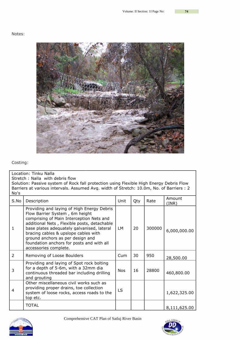
Comprehensive CAT Plan of Satluj River Basin
Notes:
Costing:
Location: Tinku Nalla
Stretch : Nalla with debris flow
Solution: Passive system of Rock fall protection using Flexible High Energy Debris Flow
Barriers at various intervals. Assumed Avg. width of Stretch: 10.0m, No. of Barriers :
No's
S.No Description
1
Providing and laying of High Energy Debris
Flow Barrier System , 6m height
comprising of Main Interception Nets and
additional Nets , Flexible posts, detachable
base plates adequately galvanised,
bracing cables & upslope cables with
ground anchors as per design and
foundation anchors for posts and with all
accessories complete.
2 Removing of Loose Boulders
3
Providing and laying of Spot rock bolting
for a depth of 5-6m, with a 32mm dia
continuous threaded bar including drilling
and grouting
4
Other miscellaneous civil works such as
providing proper drains, toe collection
system of loose rocks, access roads to the
top etc.
TOTAL
Volume: II Section: 1I Page No:
hensive CAT Plan of Satluj River Basin
Solution: Passive system of Rock fall protection using Flexible High Energy Debris Flow
Barriers at various intervals. Assumed Avg. width of Stretch: 10.0m, No. of Barriers :
Unit Qty Rate Amount
(INR)
Providing and laying of High Energy Debris
Flow Barrier System , 6m height
comprising of Main Interception Nets and
additional Nets , Flexible posts, detachable
base plates adequately galvanised, lateral
bracing cables & upslope cables with
ground anchors as per design and
foundation anchors for posts and with all
LM 20 300000
6,000,000.00
Cum 30 950
28,500.00
Providing and laying of Spot rock bolting
6m, with a 32mm dia
continuous threaded bar including drilling Nos 16 28800
460,800.00
Other miscellaneous civil works such as
providing proper drains, toe collection
system of loose rocks, access roads to the LS
1,622,325.00
8,111,625.00
74
Solution: Passive system of Rock fall protection using Flexible High Energy Debris Flow
Barriers at various intervals. Assumed Avg. width of Stretch: 10.0m, No. of Barriers : 2
Amount
(INR)
6,000,000.00
28,500.00
460,800.00
1,622,325.00
8,111,625.00

Comprehensive CAT Plan of Satluj River Basin
Volume: II Section III: Page No: 75
Section 3: Landslides-Descriptions and Mitigation with costing Sg2c
PERFORMA FOR LANDSLIDE NAME OF
AREA/LOCATI
ON
LATITUDE
/LONGIT
UDE
DAMAGE/RISK
TO LIFE &
PROPERTY
MEASU
RES
TAKEN
TYPE OF
SOIL AND
ROCK
DEGREE OF
SLOPES/SEVE
RITY
OCCURREN
CE(Season)
ROAD
CONSTRUC
TION
QUA
RRY
OTHER
CONSTR
UCTIONS
NAT
URAL
NEW
PRESCRIPTION
NEW
QUANTITY
Rate/Unit
(Rs) Cost(Rs)
Chui Jakhri
(100x80m)
31'10'39"
77'01'55" Life & Property NA Clay Very Severe Rainy Yes No No Yes
CheckDams
8x1.5x1.5m
= 18 Nos 10033 1444752 Live Hedge 400 Rms 9.6 3840 Retaining Wall
Gabion
20x3x4m =
10 Nos 29131 5826200

Comprehensive CAT Plan of Satluj River Basin
Volume: II Section III: Page No: 76
Chui Jakhri

Comprehensive CAT Plan of Satluj River Basin
Volume: II Section III: Page No: 77
Sg2d
PERFORMA FOR LANDSLIDE NAME OF
AREA/LOCATI
ON
LATITUDE/L
ONGITUDE
DAMAGE/RIS
K TO LIFE &
PROPERTY
MEASU
RES
TAKEN
TYPE OF
SOIL AND
ROCK
DEGREE OF
SLOPES/SE
VERITY
OCCURREN
CE(Season)
ROAD
CONSTRUCTI
ON
QUAR
RY
OTHER
CONSTRUC
TIONS
NATU
RAL
NEW
PRESCRIPTION
NEW
QUANTITY
Rate/
Unit
(Rs) Cost(Rs)
Thachi (500m
x 50m)
31'12'16"
77'05'22"
Property and
life. Nil
Clay &
Loose
stone Severe Rainy Yes No No Yes
Brushwood 40 Rms 62 2480 Live Hedge 300 Rms 9.6 2880 Retaining Wall
Gabion
20x1.5x1.5m
= 11 Nos 10033 2207260 Retaining Wall
Gabion
15x1.5x1.5m
= 14 Nos 10033 2106930
Thachi

Comprehensive CAT Plan of Satluj River Basin
Volume: II Section III: Page No: 78
Sh2c
PERFORMA FOR LANDSLIDE
NAME OF
AREA/LOCATI
ON
LATITUDE/L
ONGITUDE
DAMAGE/RIS
K TO LIFE &
PROPERTY
MEASURES
TAKEN
TYPE OF
SOIL AND
ROCK
DEGREE OF
SLOPES/SE
VERITY
OCCURRE
NCE(Seas
on)
ROAD
CONSTR
UCTION
QUA
RRY
OTHER
CONSTRU
CTIONS
NAT
URAL
NEW
PRESCRIPTION
NEW
QUANTITY
Rate/Unit
(Rs) Cost(Rs)
Bigan
(50mx500m)
31'28'72"
77'06'44"
Life &
Property
Check dams
dry stone qty
12 exists.
Loose
stone Severe Rainy Yes No No Yes
Brushwood 10 Rms 62 620
CheckDams
10x2.5x3
m=8 Nos 20177 1614160 Live Hedge 300 Rms 9.6 2880
Bigan

Comprehensive CAT Plan of Satluj River Basin
Volume: II Section III: Page No: 79
Si2f
PERFORMA FOR LANDSLIDE
NAME OF
AREA/LOCATI
ON
LATITUDE/L
ONGITUDE
DAMAGE/RI
SK TO LIFE &
PROPERTY
MEASU
RES
TAKEN
TYPE OF
SOIL AND
ROCK
DEGREE OF
SLOPES/SEV
ERITY
OCCURRE
NCE(Seas
on)
ROAD
CONSTRU
CTION
QUA
RRY
OTHER
CONSTRUCTI
ONS
NATU
RAL
NEW
PRESCRIPTION
NEW
QUANTITY
Rate/
Unit
(Rs) Cost(Rs)
Duga Nala
(150m x 50m)
31'39'33"
77'24'50" Property NA Clay Severe Rainy No No No Yes
Brushwood 10 Rms 62 620 Live Hedge 500 Rms 9.6 4800 Retaining Wall
Gabion
15x3x4m
=8 Nos 29131 3495720
Duga Nala

Comprehensive CAT Plan of Satluj River Basin
Volume: II Section III: Page No: 80
Si2h
PERFORMA FOR LANDSLIDE
NAME OF
AREA/LOCATI
ON
LATITUDE/L
ONGITUDE
DAMAGE/RIS
K TO LIFE &
PROPERTY
MEASU
RES
TAKEN
TYPE OF
SOIL AND
ROCK
DEGREE OF
SLOPES/SEV
ERITY
OCCUR
RENCE(
Season)
ROAD
CONSTRUC
TION
QUAR
RY
OTHER
CONSTRUC
TIONS
NATU
RAL
NEW
PRESCRIPTION
NEW
QUANTITY
Rate/
Unit
(Rs) Cost(Rs)
Naswar (50m x
1500m)
31'41'97"
77'23'23"
Life &
Property NA Clay Severe Rainy No No No Yes
Brushwood 40 Rms 62 2480 Live Hedge 600 Rms 9.6 5760 Retaining Wall
Gabion
15x2x2.5m
=22 Nos 17277 5701410 Retaining Wall
Gabion
20x3x4m
=11 Nos 29131 6408820
Naswar

Comprehensive CAT Plan of Satluj River Basin
Volume: II Section III: Page No: 81
Si3f
PERFORMA FOR LANDSLIDE
NAME OF
AREA/LOCATI
ON
LATITUDE/L
ONGITUDE
DAMAGE/RIS
K TO LIFE &
PROPERTY
MEASUR
ES
TAKEN
TYPE OF
SOIL AND
ROCK
DEGREE OF
SLOPES/SEV
ERITY
OCCUR
RENCE(
Season)
ROAD
CONSTRUC
TION
QUA
RRY
OTHER
CONSTRUC
TIONS
NATU
RAL
NEW
PRESCRIPTION
NEW
QUANTITY
Rate/Unit
(Rs) Cost(Rs)
Malani
(100mx100m)
31'38'00"
77'30'02" Property NA CLAY Severe Rainy Yes No No Yes
Brushwood 15 Rms 62 930 Live Hedge 200 Rms 9.6 1920 Retaining Wall
Gabion
15x3x4m
= 05 Nos 29131 2184825
Malani

Comprehensive CAT Plan of Satluj River Basin
Volume: II Section III: Page No: 82
Sj1e
PERFORMA FOR LANDSLIDE
NAME OF
AREA/LOCATI
ON
LATITUDE/L
ONGITUDE
DAMAGE/RI
SK TO LIFE &
PROPERTY
MEASU
RES
TAKEN
TYPE OF
SOIL AND
ROCK
DEGREE OF
SLOPES/SEV
ERITY
OCCUR
RENCE(
Season)
ROAD
CONSTRUC
TION
QUA
RRY
OTHER
CONSTRUC
TIONS
NATU
RAL
NEW
PRESCRI
PTION NEW QUANTITY
Rate/
Unit
(Rs) Cost(Rs)
Jigyarlu
Querry Site
(200mx200m)
31'11'36"
77'12'44" Property NA Loose stone Very severe Rainy No Yes No No
Retainin
g Wall
Gabion
200x2x2.5m = 01
Nos, Stopage of
quarry. 17277 3455400
Jigyarlu Querry Site

Comprehensive CAT Plan of Satluj River Basin
Volume: II Section III: Page No: 83
Sj1h
PERFORMA FOR LANDSLIDE
NAME OF
AREA/LOCATI
ON
LATITUDE/
LONGITUD
E
DAMAGE/RISK
TO LIFE &
PROPERTY
MEASUR
ES
TAKEN
TYPE OF
SOIL AND
ROCK
DEGREE OF
SLOPES/SE
VERITY
OCCURREN
CE(Season)
ROAD
CONSTR
UCTION
QUA
RRY
OTHER
CONSTRU
CTIONS
NAT
URAL
NEW
PRESCRIPTION
NEW
QUANTITY
Rate/
Unit
(Rs) Cost(Rs)
Kadeog
(500mx1000m
)
31'08'46"
77'18'36" Life & Property NA
Loose
stone Severe Rainy Yes No No Yes
CheckDams
20x3x4m = 16
Nos 29131 9321920
CheckDams
15x3x4m = 22
Nos 29131 9613230
CheckDams
12x3x4m = 17
Nos 29131 5942724 Live Hedge 1500 Rms 9.6 14400 Silt Detention
Dams in Gabion
30x3x4m = 03
Nos 29131 2621790
Kiari
(500mx500m)
31'08'20"
77'18'44" Property
Check
dams dry
stone
Loose
stone Severe Rainy Yes NA NA Yes
Live Hedge 250 Rms 9.6 2400 Retaining Wall
Gabion
20x3x4m = 28
Nos 29131 16313360 Retaining Wall
Gabion
12x3x4m = 20
Nos 29131 6991440 Retaining Wall
Gabion
10x3x4m = 14
Nos 29131 4078340

Comprehensive CAT Plan of Satluj River Basin
Volume: II Section III: Page No: 84
Kiari Kadeog

Comprehensive CAT Plan of Satluj River Basin
Volume: II Section III: Page No: 85
Sj1m
PERFORMA FOR LANDSLIDE
NAME OF
AREA/LOCATI
ON
LATITUDE/L
ONGITUDE
DAMAGE/RIS
K TO LIFE &
PROPERTY
MEASU
RES
TAKEN
TYPE OF
SOIL AND
ROCK
DEGREE OF
SLOPES/SE
VERITY
OCCURRE
NCE(Seas
on)
ROAD
CONSTR
UCTION
QU
ARR
Y
OTHER
CONSTR
UCTIONS
NAT
URAL NEW PRESCRIPTION
NEW
QUANTITY
Rate/
Unit
(Rs) Cost(Rs)
Dhanaut
(200m x100m)
31'07'31"
77'21'32" Property NA Clay Very severe
Rainy &
due to
drainage
of Upper
City Yes No No Yes
Live Hedge 1500Rms 9.6 14400 Safe water disposal
structures with cement
concret in two Nalas approx
2 Kms length below Theog
Comittee area to Chikhar
Khad 1500Rms
Dhanaut

Comprehensive CAT Plan of Satluj River Basin
Volume: II Section III: Page No: 86
Sj2a
PERFORMA FOR LANDSLIDE
NAME OF
AREA/LOCATI
ON
LATITUDE/L
ONGITUDE
DAMAGE/RIS
K TO LIFE &
PROPERTY
MEASURE
S TAKEN
TYPE OF
SOIL AND
ROCK
DEGREE OF
SLOPES/SE
VERITY
OCCURRE
NCE(Seas
on)
ROAD
CONSTRUC
TION
QUA
RRY
OTHER
CONSTRU
CTIONS
NAT
URAL
NEW
PRESCRIPTION
NEW
QUANTITY
Rate/
Unit
(Rs) Cost(Rs)
Jashi
(50mx300m)
31'25'23"
77'21'57" Property Nil
Clay &
Loose
stone Severe Rainy Yes No No Yes
Brushwood 100 Rms 62 6200 Retaining Wall
Gabion
15x3x4m=5
Nos 29131 2184825
TABLE 9 PHOTOS Jashi

Comprehensive CAT Plan of Satluj River Basin
Volume: II Section III: Page No: 87
Sj2d
PERFORMA FOR LANDSLIDE
NAME OF
AREA/LOCATI
ON
LATITUDE/L
ONGITUDE
DAMAGE/RI
SK TO LIFE &
PROPERTY
MEAS
URES
TAKEN
TYPE OF
SOIL AND
ROCK
DEGREE OF
SLOPES/SEVE
RITY
OCCURR
ENCE(Se
ason)
ROAD
CONSTRU
CTION
QUAR
RY
OTHER
CONSTRUC
TIONS
NATU
RAL
NEW
PRESCRIPTION
NEW
QUANTITY
Rate/
Unit
(Rs) Cost(Rs)
Drabra (5
Hact)
31'24'19"
77'31'67" Property NA CLAY VERY SEVERE Rainy Yes No No Yes
Brushwood 1200 Rms 62 74400 Retaining Wall
Gabion
12x2x2.5m=
12 Nos 17277 2487888 Retaining Wall
Gabion
15x2x2.5m=
60 Nos 17277 15549300
Drabr

Comprehensive CAT Plan of Satluj River Basin
Volume: II Section III: Page No: 88
Sj2h
PERFORMA FOR LANDSLIDE
NAME OF
AREA/LOCATI
ON
LATITUDE/L
ONGITUDE
DAMAGE/RI
SK TO LIFE &
PROPERTY
MEAS
URES
TAKEN
TYPE OF
SOIL AND
ROCK
DEGREE OF
SLOPES/SEV
ERITY
OCCURR
ENCE(Se
ason)
ROAD
CONSTRU
CTION
QUA
RRY
OTHER
CONSTRUCTI
ONS
NAT
URAL
NEW
PRESCRIPTION NEW QUANTITY
Rate/
Unit
(Rs) Cost(Rs)
Kopri Jubbal
(50mx30m)
31'18'51"
77'21'48" Property NA CLAY Severe Rainy No No No Yes
Brushwood 15 Rms 62 930 Live Hedge 300 Rms 9.6 2880 Retaining Wall
Gabion
6x1.5x1.5m=4
Nos 10033 240792 Retaining Wall
Gabion
10x2x2.5m=3
Nos 17277 518310
Kopri Jubbal

Comprehensive CAT Plan of Satluj River Basin
Volume: II Section III: Page No: 89
Sk1a
PERFORMA FOR LANDSLIDE
NAME OF
AREA/LOCATI
ON
LATITUDE/L
ONGITUDE
DAMAGE/RISK
TO LIFE &
PROPERTY
MEASU
RES
TAKEN
TYPE OF
SOIL AND
ROCK
DEGREE OF
SLOPES/SE
VERITY
OCCURR
ENCE(Se
ason)
ROAD
CONSTRU
CTION
QUA
RRY
OTHER
CONSTR
UCTIONS
NATU
RAL
NEW
PRESCRIPTION
NEW
QUANTITY
Rate/
Unit
(Rs) Cost(Rs)
Tadasha Nala
(100mx60m)
31'38'77"
77'41'57" Property NA Clay
Very
Severe Rainy No No No Yes
Brushwood 50 Rms 62 3100 Live Hedge 150 Rms 9.6 1440 Retaining Wall
Gabion
10x2x2.5m=06
Nos 17277 1036620 Retaining Wall
Gabion
15x2.5x3m=08
Nos 20177 2421240
Tadasha,
(30mx50m)
31'38'74"
77'41'56" Property NA Clay Severe Rainy Yes No No Yes
Brushwood 20 Rms 62 1240 Live Hedge 80 Rms 9.6 768 Retaining Wall
Gabion
10x2x2.5m=03
Nos 17277 518310
TABLE 9 PHOTOS
Tadasha Tadasha Nala

Comprehensive CAT Plan of Satluj River Basin
Volume: II Section III: Page No: 90
Sk1d
PERFORMA FOR LANDSLIDE
NAME OF
AREA/LOCATI
ON
LATITUDE/L
ONGITUDE
DAMAGE/RISK
TO LIFE &
PROPERTY
MEAS
URES
TAKEN
TYPE OF
SOIL AND
ROCK
DEGREE OF
SLOPES/SEV
ERITY
OCCURR
ENCE(Se
ason)
ROAD
CONSTRUC
TION
QUA
RRY
OTHER
CONSTRU
CTIONS
NATU
RAL
NEW
PRESCRIPTION
NEW
QUANTITY
Rate/
Unit
(Rs) Cost(Rs)
Janut
(50mx50m)
31'42'07"
77'34'15" Property NA Clay severe Rainy Yes No No Yes
Brushwood 6 Rms 62 372 Live Hedge 100 Rms 9.6 960 Retaining Wall
Gabion
15x3x4m=3
Nos 29131 1310895
Janut

Comprehensive CAT Plan of Satluj River Basin
Volume: II Section III: Page No: 91
Sk1g
PERFORMA FOR LANDSLIDE
NAME OF
AREA/LOCATI
ON
LATITUDE/L
ONGITUDE
DAMAGE/RI
SK TO LIFE &
PROPERTY
MEASU
RES
TAKEN
TYPE OF
SOIL AND
ROCK
DEGREE OF
SLOPES/SE
VERITY
OCCURRE
NCE(Seas
on)
ROAD
CONSTRU
CTION
QU
ARR
Y
OTHER
CONSTR
UCTIONS
NAT
URAL
NEW
PRESCRIPTION
NEW
QUANTITY Rate/Unit (Rs) Cost(Rs)
Tarala
(100mx50m)
31'42'65"
77'28'99" Life NA CLAY severe Rainy Yes No No Yes
Brushwood 10 Rms 62 620 Live Hedge 200 Rms 9.6 1920 Retaining Wall
Gabion
15x3x4m=4
Nos 29131 1747860 Retaining Wall
Gabion
10x3x4m=2
Nos 29131 582620
Tarala

Comprehensive CAT Plan of Satluj River Basin
Volume: II Section III: Page No: 92
Sk1h
PERFORMA FOR LANDSLIDE
NAME OF
AREA/LOCATI
ON
LATITUDE/L
ONGITUDE
DAMAGE/RISK
TO LIFE &
PROPERTY
MEAS
URES
TAKEN
TYPE OF
SOIL AND
ROCK
DEGREE OF
SLOPES/SE
VERITY
OCCURR
ENCE(Se
ason)
ROAD
CONSTRUC
TION
QUAR
RY
OTHER
CONSTRU
CTIONS
NAT
URAL
NEW
PRESCRIPTION
NEW
QUANTITY
Rate/Unit
(Rs) Cost(Rs)
Bara Nal
(300mx50m)
31'52'16"
77'34'69" Property NA Clay Severe Rainy No No No Yes
Brushwood 15 Rms 62 930 Live Hedge 70 Rms 9.6 672 Retaining Wall
Gabion
15x2x2.5m=
07Nos 17277 1814085 Retaining Wall
Gabion
10x2x2.5m=
02Nos 17277 345540 Retaining Wall
Gabion
8x2x2.5m=0
3Nos 17277 414648
Bara Nal

Comprehensive CAT Plan of Satluj River Basin
Volume: II Section III: Page No: 93
Sk1m
PERFORMA FOR LANDSLIDE
NAME OF
AREA/LOCATI
ON
LATITUDE/L
ONGITUDE
DAMAGE/RISK
TO LIFE &
PROPERTY
MEASU
RES
TAKEN
TYPE OF
SOIL AND
ROCK
DEGREE OF
SLOPES/SEV
ERITY
OCCUR
RENCE(
Season)
ROAD
CONSTRUC
TION
QUA
RRY
OTHER
CONSTRU
CTIONS
NATU
RAL
NEW
PRESCRIPTION
NEW
QUANTITY
Rate/Unit
(Rs) Cost(Rs)
Banigad
(50mx50m)
31'46'52"
77'42'62" Property NA Clay Severe Rainy No No No Yes
Brushwood 15 Rms 62 930 Live Hedge 50 Rms 9.6 480 Retaining Wall
Gabion
15x2x2.5m=5
Nos. 17277 1295775 Retaining Wall
Gabion
40x3x4m=01
No 29131 1165240
Sarali
(3000mx500m
)
31'47'32"
77'43'12" Property NA Clay Severe Rainy No No No Yes
Brushwood 15 Rms 62 930 Live Hedge 150 Rms 9.6 1440 Retaining Wall
Gabion
10x2x2.5m=1
0 Nos 17277 1727700 Retaining Wall
Gabion
15x2x2.5m=1
1Nos 17277 2850705
Banigad Sarali

Comprehensive CAT Plan of Satluj River Basin
Volume: II Section III: Page No: 94
Sk1n
PERFORMA FOR LANDSLIDE
NAME OF
AREA/LOCATI
ON
LATITUDE/
LONGITUD
E
DAMAGE/
RISK TO
LIFE &
PROPERTY
MEASU
RES
TAKEN
TYPE
OF SOIL
AND
ROCK
DEGREE
OF
SLOPES/
SEVERITY
OCCUR
RENCE(
Season)
ROAD
CONSTR
UCTION
QUA
RRY
OTHER
CONST
RUCTI
ONS
NAT
URAL NEW PRESCRIPTION NEW QUANTITY
Rate/U
nit (Rs) Cost(Rs)
Chalidhar
(2Kmsx150m)
31'52'62"
77'37'93" Property NA Clay Severe Rainy No No No Yes
Brushwood 40 Rms 62 2480 CheckDams 3x1.5x1.5m = 40 Nos 10033 1203960 Diversion of water at upstream
with safe drainage of 30 m at
both side. NA Live Hedge 300 Rms 9.6 2880 Retaining Wall Gabion 15x3x4m = 7 Nos 29131 3058755
Jaged Nala
(500mx200m)
31'51'99"
77'41'14"
Property
& Life NA Clay
Very
Severe Rainy No No No Yes
Brushwood 30 Rms 62 1860 Diversion of water at upstream
with safe drainage of 15 m at
both side. NA Live Hedge 300 Rms 9.6 2880 Retaining Wall Gabion 3x1.5x1.5m = 18 Nos 10033 541782
Karsai Gad
(1.5Kmsx500m
)
31'52'66"
77'38'22"
Property
& Life NA Clay Severe Rainy No No No Yes
Brushwood 100 Rms 62 6200 CheckDams 3x1.5x1.5m = 22 Nos 10033 662178 Diversion of water at upstream
with safe drainage of 20 m at
both side. NA Live Hedge 200 Rms 9.6 1920 Retaining Wall Gabion 15x3x4m = 4 Nos 29131 1747860
Khanag Nala
(1.5Kmsx500m
)
31'52'74"
77'40'18" Property NA Clay
Moderat
e Rainy No No No Yes
Brushwood 100 Rms 62 6200 Diversion of water at upstream
with safe drainage of 10 m at
both side. NA Live Hedge 450 Rms 9.6 4320 Retaining Wall Gabion 3x1.5x1.5m = 25 Nos 10033 752475

Comprehensive CAT Plan of Satluj River Basin
Volume: II Section III: Page No: 95
Kot Nala
(1000mx1000
m)
31'51'51"
77'41'76"
Property
& Life NA Clay
Very
Severe Rainy No No No Yes
Brushwood 50 Rms 62 3100 Diversion of water at upstream
with safe drainage of 15 m at
both side. NA Live Hedge 300 Rms 9.6 2880 Retaining Wall Gabion 3x1.5x1.5m = 20 Nos 10033 601980 Retaining Wall Gabion 20x3x4m = 4 Nos 29131 2330480
Jaged Nala Kot Nala Khanag Nala
Karsai Gad Chalidhar

Comprehensive CAT Plan of Satluj River Basin
Volume: II Section III: Page No: 96
Sm1a
PERFORMA FOR LANDSLIDE
NAME OF
AREA/LOCATI
ON
LATITUDE/L
ONGITUDE
DAMAGE/RIS
K TO LIFE &
PROPERTY
MEASU
RES
TAKEN
TYPE OF
SOIL AND
ROCK
DEGREE OF
SLOPES/SEV
ERITY
OCCURR
ENCE(Se
ason)
ROAD
CONSTRU
CTION
QUA
RRY
OTHER
CONSTRU
CTIONS
NATU
RAL
NEW
PRESCRIPTION
NEW
QUANTITY
Rate/
Unit
(Rs) Cost(Rs)
Badanal
(100mx60m)
31'34'45"
77'42'69" Property NA
Loose
stone Moderate Rainy No No No Yes
Brushwood 10 Rms 62 620 Live Hedge 100 Rms 9.6 960 Retaining Wall
Gabion
5x1.5x1.5m =
10 Nos 10033 501650
Karsha,
(100mx100m)
31'36'21"
77'39'79" Property NA
Clay with
loose
stones Severe Rainy No No No Yes
Live Hedge 100 Rms 9.6 960 Retaining Wall
Gabion
15x2.5x3m =
04 Nos 20177 1210620 Retaining Wall
Gabion
70x2.5x3m =
01 No 20177 1412390
Karsha Badanal

Comprehensive CAT Plan of Satluj River Basin
Volume: II Section III: Page No: 97
Sm2b
PERFORMA FOR LANDSLIDE
NAME OF
AREA/LOCATI
ON
LATITUDE/L
ONGITUDE
DAMAGE/RI
SK TO LIFE &
PROPERTY
MEASUR
ES
TAKEN
TYPE OF
SOIL AND
ROCK
DEGREE OF
SLOPES/SE
VERITY
OCCURR
ENCE(Se
ason)
ROAD
CONSTRUC
TION
QUA
RRY
OTHER
CONSTRUC
TIONS NATURAL
NEW
PRESCRIP
TION
NEW
QUANTITY
Rate/
Unit
(Rs) Cost(Rs)
Sabhaur
(250Mx20m)
31'40'82"
77'56'56"
Both Life
and property NA
Clay &
Sand
LESS
SEVERE Rainy NA NA NA
Yes, due to heavy
flow of water in
Kurpan Khad.
Brushwoo
d 50 Rms 62 3100 Yes, due to heavy
flow of water in
Kurpan Khad.
Live
Hedge 100 Rms 9.6 960 Yes, due to heavy
flow of water in
Kurpan Khad.
Retaining
Wall
Gabion
250x2.5x3
m=1 Nos 20177 5044250
Sabhaur

Comprehensive CAT Plan of Satluj River Basin
Volume: II Section III: Page No: 98
Sm2f
PERFORMA FOR LANDSLIDE
NAME OF
AREA/LOCATI
ON
LATITUDE/L
ONGITUDE
DAMAGE/RISK
TO LIFE &
PROPERTY
MEASU
RES
TAKEN
TYPE OF
SOIL AND
ROCK
DEGREE OF
SLOPES/SEV
ERITY
OCCURREN
CE(Season)
ROAD
CONSTRUC
TION
QUA
RRY
OTHER
CONSTRU
CTIONS
NAT
URAL
NEW
PRESCRIPTIO
N
NEW
QUANTITY
Rate/Unit
(Rs) Cost(Rs)
Chenai
(500mx40m)
31'53'88"
77'54'13" Property NA Clay Severe Rainy Yes No No Yes
Brushwood 35 Rms 62 2170 Live Hedge 200 Rms 9.6 1920 Retaining
Wall Gabion
10x1.5x1.5m
=12 Nos 10033 1203960 Retaining
Wall Gabion
20x1.5x1.5m
=7 Nos 10033 1404620 Retaining
Wall Gabion
40x1.5x1.5m
=2 Nos 10033 802640
Deogi
(200mx20m)
31'54'38"
77'52'93" Property NA
Clay &
Loose
stones Severe Rainy Yes No No Yes
Brushwood 15 Rms 62 930
CheckDams
7x1.5x1.5m=
9 Nos 10033 632079
CheckDams
10x1.5x1.5m
=11Nos 10033 1103630 Live Hedge 100 Rms 9.6 960

Comprehensive CAT Plan of Satluj River Basin
Volume: II Section III: Page No: 99
Deogi Chenai

Comprehensive CAT Plan of Satluj River Basin
Volume: II Section III: Page No: 100
Sm2j
PERFORMA FOR LANDSLIDE
NAME OF
AREA/LOCATI
ON
LATITUDE/L
ONGITUDE
DAMAGE/RIS
K TO LIFE &
PROPERTY
MEAS
URES
TAKEN
TYPE OF
SOIL AND
ROCK
DEGREE OF
SLOPES/SE
VERITY
OCCURR
ENCE(Se
ason)
ROAD
CONSTRUC
TION
QUA
RRY
OTHER
CONSTRU
CTIONS
NAT
URAL
NEW
PRESCRIPTION
NEW
QUANTITY
Rate/Unit
(Rs) Cost(Rs)
Sili Girchi
(200mx30m)
31'57'33"
77'58'24" Property NA
Clay &
loose
stones
VERY
SEVERE Rainy No No No Yes
Brushwood 8 Rms 62 496 Live Hedge 100 Rms 9.6 960 Retaining Wall
Gabion
10x2x2.5m=6
Nos 17277 1036620 Retaining Wall
Gabion
30x2x2.5m=1N
os 17277 518310
Sili Girchi

Comprehensive CAT Plan of Satluj River Basin
Volume: II Section III: Page No: 101
Sn1a
PERFORMA FOR LANDSLIDE
NAME OF
AREA/LOCATI
ON
LATITUDE/L
ONGITUDE
DAMAGE/RI
SK TO LIFE &
PROPERTY
MEASU
RES
TAKEN
TYPE OF
SOIL AND
ROCK
DEGREE OF
SLOPES/SE
VERITY
OCCURRE
NCE(Seas
on)
ROAD
CONSTRU
CTION
QU
ARR
Y
OTHER
CONSTRUC
TIONS
NATU
RAL
NEW
PRESCRIPTION
NEW
QUANTITY
Rate/U
nit (Rs) Cost(Rs)
Badu
(300mx50m)
31'21'27"
77'22'14" Property NA Sand Severe Rainy No No No Yes
Brushwood 60 Rms 62 3720 Live Hedge 100 Rms 9.6 960 Retaining Wall
Gabion
30x3x4m=2
Nos 29131 1747860
Malalbai
(200mx50m)
31'21'13"
77'23'30" Property NA SAND Severe Rainy No No No Yes
Brushwood 50 Rms 62 3100 Live Hedge 100 Rms 9.6 960 Retaining Wall
Gabion
200x3x4m=1
Nos. 29131 5826200
Panu Dhar
(300mx50m)
31'20'07"
77'23'27" Property NA CLAY
VERY
SEVERE Rainy No No No Yes
Brushwood 10 Rms 62 620 Live Hedge 60 Rms 9.6 576 Retaining Wall
Gabion
15x3x4m=7N
os. 29131 3058755
Panu Dhar Malalbai Badu

Comprehensive CAT Plan of Satluj River Basin
Volume: II Section III: Page No: 102
Sn1b
PERFORMA FOR LANDSLIDE
NAME OF
AREA/LOCATI
ON
LATITUDE/L
ONGITUDE
DAMAGE/RIS
K TO LIFE &
PROPERTY
MEASU
RES
TAKEN
TYPE OF
SOIL AND
ROCK
DEGREE OF
SLOPES/SE
VERITY
OCCURR
ENCE(Se
ason)
ROAD
CONSTRU
CTION
QUA
RRY
OTHER
CONSTRU
CTIONS
NATU
RAL
NEW
PRESCRIPTION
NEW
QUANTITY
Rate/Unit
(Rs) Cost(Rs)
Sablog Kenchi
(500mx100m)
31'17'28"
77'24'51" Property NA Clay MODERATE Rainy No No No Yes
Brushwood 50 Rms 62 3100 Live Hedge 300 Nos 9.6 2880 Retaining Wall
Gabion
10x1.5x1.5m=
10Nos 10033 1003300 Retaining Wall
Gabion
200x3x4m=7
Nos 29131 40783400
Sablog Kenchi

Comprehensive CAT Plan of Satluj River Basin
Volume: II Section III: Page No: 103
Sn1c
PERFORMA FOR LANDSLIDE
NAME OF
AREA/LOCATI
ON
LATITUDE/L
ONGITUDE
DAMAGE/RI
SK TO LIFE &
PROPERTY
MEASU
RES
TAKEN
TYPE OF
SOIL AND
ROCK
DEGREE OF
SLOPES/SE
VERITY
OCCURRE
NCE(Seas
on)
ROAD
CONSTRUC
TION
QUA
RRY
OTHER
CONSTRUC
TIONS
NAT
URAL
NEW
PRESCRIPTION
NEW
QUANTITY
Rate/Unit
(Rs) Cost(Rs)
Sawari
(200mx200m)
31'17'54"
77'27'50" Property NA Clay
VERY
SEVERE Rainy No No No Yes
Brushwood 10 Rms 62 620 Live Hedge 300 Rms 9.6 2880 Retaining Wall
Gabion
7x2x2.5m=4
Nos 17277 483756 Retaining Wall
Gabion
10x2x2.5m=4
Nos 17277 691080 Retaining Wall
Gabion
15x2x2.5m=2
Nos 17277 518310 Retaining Wall
Gabion
20x3x4m=01N
os 29131 582620
Sawari

Comprehensive CAT Plan of Satluj River Basin
Volume: II Section III: Page No: 104
Sn1d
PERFORMA FOR LANDSLIDE
NAME OF
AREA/LOCATI
ON
LATITUDE/L
ONGITUDE
DAMAGE/RI
SK TO LIFE &
PROPERTY
MEASU
RES
TAKEN
TYPE OF
SOIL AND
ROCK
DEGREE OF
SLOPES/SE
VERITY
OCCURR
ENCE(Se
ason)
ROAD
CONSTRU
CTION
QUA
RRY
OTHER
CONSTR
UCTIONS
NATU
RAL NEW PRESCRIPTION
NEW
QUANTITY
Rate/
Unit
(Rs) Cost(Rs)
Kalimiti
(500mx300m)
31'20'50"
77'30'19"
Property &
Life NA
Clay and
loose
stone
VERY
SEVERE Rainy No No No Yes
Brushwood 25 Rms 62 1550 Diversion of water at
upstream with safe
drainage of 20 m at right
side of slide. NA Live Hedge 100 Rms 9.6 960
Retaining Wall Gabion
15x3x4m=3
Nos 29131 1310895
Kalimiti

Comprehensive CAT Plan of Satluj River Basin
Volume: II Section III: Page No: 105
Sn1f
PERFORMA FOR LANDSLIDE
NAME OF
AREA/LOCATI
ON
LATITUDE/L
ONGITUDE
DAMAGE/RI
SK TO LIFE &
PROPERTY
MEAS
URES
TAKEN
TYPE OF
SOIL AND
ROCK
DEGREE OF
SLOPES/SE
VERITY
OCCURR
ENCE(Se
ason)
ROAD
CONSTRUCTI
ON
QUA
RRY
OTHER
CONSTRUC
TIONS
NATU
RAL
NEW
PRESCRIPTION
NEW
QUANTITY
Rate/
Unit
(Rs) Cost(Rs)
Khari
(150mx25m)
31'17'04"
77'27'11" Property NA
Clay &
Loose
stone Severe Rainy No No No Yes
Brushwood 15 Rms 62 930
CheckDams
7x2.5x3m=9
Nos 20177 1271151 Live Hedge 150 Rms 9.6 1440
Marni-
I(200mx100m)
31'15'39"
77'28'45" Property NA CLAY Severe Rainy No No No Yes
Brushwood 25 Rms 62 1550 Live Hedge 100 Rms 9.6 960 Retaining Wall
Gabion
7x3x4m=12
Nos 29131 2447004
Marni-II
(300mx200m)
31'16'27"
77'29'03" Property NA Clay Severe Rainy No No No Yes
Brushwood 30 Rms 62 1860 Live Hedge 100 Rms 9.6 960 Retaining Wall
Gabion
15x3x4m=6
Nos 29131 2621790
Khari Marni-I Marni-II

Comprehensive CAT Plan of Satluj River Basin
Volume: II Section III: Page No: 106
Sn2a
PERFORMA FOR LANDSLIDE
NAME OF
AREA/LOCATI
ON
LATITUDE/L
ONGITUDE
DAMAGE/RI
SK TO LIFE &
PROPERTY
MEASUR
ES
TAKEN
TYPE OF
SOIL AND
ROCK
DEGREE OF
SLOPES/SEV
ERITY
OCCURR
ENCE(Se
ason)
ROAD
CONSTRUC
TION
QUA
RRY
OTHER
CONSTRUC
TIONS
NAT
URAL
NEW
PRESCRIPTION
NEW
QUANTITY
Rate/Unit
(Rs) Cost(Rs)
Barawag
(400mx300m)
31'19'25"
77'32'07" Property NA CLAY MODERATE Rainy No No No Yes
Brushwood 15 Rms 62 930 Live Hedge 180 Rms 9.6 1728 Retaining Wall
Gabion
15x2x2.5m=
9 Nos 17277 2332395 Retaining Wall
Gabion
10x2x2.5m=
13 Nos 17277 2246010
Chaber
(1000mx500m
)
31'20'05"
77'31'56" Property NA Clay Moderate Rainy Yes No No Yes
Brushwood 30 Rms 62 1860 Live Hedge 160 Rms 9.6 1536 Retaining Wall
Gabion
15x2x2.5m=
7Nos 17277 1814085 Retaining Wall
Gabion
10x2x2.5m=
10 No 17277 1727700
Barawag Chaber

Comprehensive CAT Plan of Satluj River Basin
Volume: II Section III: Page No: 107
Sn2d
PERFORMA FOR LANDSLIDE
NAME OF
AREA/LOCATI
ON
LATITUDE/L
ONGITUDE
DAMAGE/RI
SK TO LIFE &
PROPERTY
MEAS
URES
TAKEN
TYPE OF
SOIL AND
ROCK
DEGREE OF
SLOPES/SEV
ERITY
OCCURRE
NCE(Seas
on)
ROAD
CONSTRU
CTION
QUAR
RY
OTHER
CONSTRUC
TIONS
NAT
URAL
NEW
PRESCRIPTION
NEW
QUANTITY
Rate/
Unit
(Rs) Cost(Rs)
Barkha
(200mx150m)
31'15'51"
77'33'03" Property NA CLAY Severe Rainy No No No Yes
Brushwood 12 Rms 62 744 Live Hedge 180 Rms 9.6 1728 Retaining Wall
Gabion
20x2x2.5m=6
Nos 17277 2073240
Barkha

Comprehensive CAT Plan of Satluj River Basin
Volume: II Section III: Page No: 108
Sn2f
PERFORMA FOR LANDSLIDE
NAME OF
AREA/LOCATI
ON
LATITUDE/L
ONGITUDE
DAMAGE/RIS
K TO LIFE &
PROPERTY
MEASUR
ES
TAKEN
TYPE OF
SOIL AND
ROCK
DEGREE OF
SLOPES/SE
VERITY
OCCUR
RENCE(
Season)
ROAD
CONSTRUC
TION
QUA
RRY
OTHER
CONSTRUC
TIONS
NAT
URAL
NEW
PRESCRIPTION
NEW
QUANTITY
Rate/Unit
(Rs) Cost(Rs)
Arhi Gad,
1500mx20m
31'21'31"
77'35'57"
Risk to life
and property NA
Loose
stone Severe Rainy No No No Yes
Brushwood 80 Rms 62 4960
CheckDams
5x1.5x1.5m=8
Nos 10033 401320
CheckDams
8x1.5x1.5m=1
6 Nos 10033 1284224
CheckDams
10x1.5x1.5m=
25 Nos 10033 2508250 Live Hedge 400 Rms 9.6 3840
Nau Nala,
100mx50m
31'21'53"
77'34'02"
Road and
private land NA CLAY
VERY
SEVERE Rainy No Yes No Yes
Live Hedge 150 Rms 9.6 1440 Retaining Wall
Gabion
100x1.5x1.5m
=1 No 10033 1003300
Nau Nala Arhi Gad

Comprehensive CAT Plan of Satluj River Basin
Volume: II Section III: Page No: 109
Sn2g
PERFORMA FOR LANDSLIDE
NAME OF
AREA/LOCATI
ON
LATITUDE/L
ONGITUDE
DAMAGE/RIS
K TO LIFE &
PROPERTY
MEAS
URES
TAKEN
TYPE OF
SOIL AND
ROCK
DEGREE OF
SLOPES/SEV
ERITY
OCCURR
ENCE(Se
ason)
ROAD
CONSTR
UCTION
QUA
RRY
OTHER
CONSTR
UCTIONS
NATU
RAL
NEW
PRESCRIPTION NEW QUANTITY
Rate/
Unit
(Rs) Cost(Rs)
Neri,
150mx50m
31'21'34"
77'36'25" Property NA Clay MODERATE Rainy Yes No No Yes
Brushwood 10 Rms 62 620 Live Hedge 70 Rms 9.6 672 Retaining Wall
Gabion
10x1.5x1.5m=16
Nos 10033 1605280 Retaining Wall
Gabion
20x1.5x1.5m=8
Nos 10033 1605280
Neri-II,
225mx100m
31'21'33"
77'36'22" Property NA Clay Moderate Rainy Yes No No Yes
Brushwood 20 Rms 62 1240 Retaining Wall
Gabion
15x1.5x1.5m=8
Nos 10033 1203960 Retaining Wall
Gabion
10x1.5x1.5m=10
Nos 10033 1003300 Retaining Wall
Gabion
7x1.5x1.5m=7
Nos 10033 491617
Shaloon,
150mx25m
31'22'16"
77'35'49" Property NA Clay Moderate Rainy Yes No No Yes
Brushwood 10 Rms 62 620 Live Hedge 100 Rms 9.6 960 Retaining Wall
Gabion 10x2x2.5m=6 Nos 17277 1036620

Comprehensive CAT Plan of Satluj River Basin
Volume: II Section III: Page No: 110
Neri Neri-II Shaloon

Comprehensive CAT Plan of Satluj River Basin
Volume: II Section III: Page No: 111
Sn2h
PERFORMA FOR LANDSLIDE
NAME OF
AREA/LOCATI
ON
LATITUDE/L
ONGITUDE
DAMAGE/RIS
K TO LIFE &
PROPERTY
MEASUR
ES
TAKEN
TYPE OF
SOIL AND
ROCK
DEGREE OF
SLOPES/SEV
ERITY
OCCURRE
NCE(Seas
on)
ROAD
CONSTRU
CTION
QUAR
RY
OTHER
CONSTRU
CTIONS
NAT
URAL
NEW
PRESCRIPTION NEW QUANTITY
Rate/
Unit
(Rs) Cost(Rs)
Bashri,
200mx75m
31'20'23"
77'40'51" Property NA Clay Severe Rainy No No No Yes
Brushwood 100 Rms 62 6200 CheckDams 7x1.5x1.5m =3 Nos 10033 210693 CheckDams 15x1.5x1.5m=6Nos 10033 902970
CheckDams
10x1.5x1.5m=4
Nos 10033 401320 Live Hedge 160 Rms 9.6 1536
Dishidhar,
100mx50m
3120'17"
77'40'59" Property NA Clay Severe Rainy No No No Yes
CheckDams
20x1.5x1.5m=4
Nos 10033 802640
CheckDams
15x1.5x1.5m=2
Nos 10033 300990
CheckDams
10x1.5x1.5m=3
Nos 10033 300990 Live Hedge 80 Rms 9.6 768
Shaili,
300mx30m
31'21'14"
77'39'24" NA NA Clay
VERY
SEVERE Rainy Yes No No Yes
Brushwood 10 Rms 62 620 Live Hedge 120 Rms 9.6 1152 Retaining Wall
Gabion
10x1.5x1.5m=15N
os 10033 1504950

Comprehensive CAT Plan of Satluj River Basin
Volume: II Section III: Page No: 112
Shaili Dishidhar Bashri

Comprehensive CAT Plan of Satluj River Basin
Volume: II Section III: Page No: 113
Sn2i
PERFORMA FOR LANDSLIDE
NAME OF
AREA/LOCATI
ON
LATITUDE/L
ONGITUDE
DAMAGE/RIS
K TO LIFE &
PROPERTY
MEASU
RES
TAKEN
TYPE OF
SOIL AND
ROCK
DEGREE OF
SLOPES/SE
VERITY
OCCURRE
NCE(Seas
on)
ROAD
CONSTRUC
TION
QUA
RRY
OTHER
CONSTRU
CTIONS
NAT
URAL
NEW
PRESCRIPTION
NEW
QUANTITY
Rate/
Unit
(Rs) Cost(Rs)
Beunthal,
400mx100m
31'20'57"
77'38'10" Property NA Clay Severe Rainy No No No Yes
Brushwood 115 Rms 62 7130
CheckDams
15x1.5x1.5m=1
8 Nos 10033 2708910
CheckDams
12x1.5x1.5m=3
Nos 10033 361188
CheckDams
20x1.5x1.5m=3
Nos 10033 601980 Live Hedge 100 Rms 9.6 960 Retaining Wall
Gabion
12x1.5x1.5m=3
Nos 10033 361188 Retaining Wall
Gabion
20x1.5x1.5m=4
Nos 10033 802640 Retaining Wall
Gabion
15x1.5x1.5m=3
Nos 10033 451485
Jalashi,
30mx30m
31'21'10"
77'23'25" NA NA Clay Severe Rainy No No No Yes
Brushwood 110 Rms 62 6820
CheckDams
15x1.5x1.5m=3
Nos 10033 451485 Live Hedge 160 Rms 9.6 1536
Jalashi-II,
50mx20m
31'18'45"
77'42'51" NA NA Clay Severe Rainy No No No Yes
CheckDams
15x1.5x1.5m=1
2 Nos 10033 1805940
CheckDams
12x1.5x1.5m=1
3 Nos 10033 1565148 Live Hedge 130 Rms 9.6 1248

Comprehensive CAT Plan of Satluj River Basin
Volume: II Section III: Page No: 114
Jalashi Jalashi-II Beunthal

Comprehensive CAT Plan of Satluj River Basin
Volume: II Section III: Page No: 115
Sn2k
PERFORMA FOR LANDSLIDE
NAME OF
AREA/LOCATI
ON
LATITUDE/L
ONGITUDE
DAMAGE/RISK
TO LIFE &
PROPERTY
MEASU
RES
TAKEN
TYPE OF
SOIL AND
ROCK
DEGREE OF
SLOPES/SE
VERITY
OCCURRE
NCE(Seas
on)
ROAD
CONSTR
UCTION
QU
ARR
Y
OTHER
CONSTR
UCTIONS
NAT
URAL
NEW
PRESCRIPTION
NEW
QUANTITY
Rate/Unit
(Rs) Cost(Rs)
Jaidhar
(500mx30m)
31'19'02"
77'39'14" Property NA Clay Severe Rainy Yes No No Yes
Live Hedge 50 Rms 9.6 480 Retaining Wall
Gabion
5x2x2.5m=04N
os 17277 345540 Retaining Wall
Gabion
10x2x2.5m=05
Nos 17277 863850 Retaining Wall
Gabion
15x2x2.5m=07
Nos 17277 1814085
Jalani
(800mx150m)
31'19'06"
77'38'58" Property NA Clay Severe Rainy Yes No No Yes
Live Hedge 180 Rms 9.6 1728 Retaining Wall
Gabion
12x1.5x1.5m=1
2 Nos 10033 1444752 Retaining Wall
Gabion
150x3x4M = 01
No 29131 4369650 Retaining Wall
Gabion
10x1.5x1.5m=1
4 Nos 10033 1404620
Karalta
(150mx20m)
31'20'37"
77'37'46" Property NA Clay Severe Rainy No No No Yes
Brushwood 40 Rms 62 2480 Live Hedge 60 Rms 9.6 576 Retaining Wall
Gabion
10x1.5x1.5m=0
3Nos 10033 300990 Retaining Wall
Gabion
12x1.5x1.5m=0
2Nos 10033 240792 Retaining Wall
Gabion
7x1.5x1.5m=03
Nos 10033 210693
Shakraida
(500mx400m)
31'19'09"
77'38'00" Property NA Clay Severe Rainy Yes No No Yes
Live Hedge 120 Rms 9.6 1152 Retaining Wall
Gabion
12x1.5x1.5m=0
3Nos 10033 361188 Retaining Wall
Gabion
10x1.5x1.5m=0
7Nos 10033 702310

Comprehensive CAT Plan of Satluj River Basin
Volume: II Section III: Page No: 116
Karalta Shakraida
Jalani Jaidhar

Comprehensive CAT Plan of Satluj River Basin
Volume: II Section III: Page No: 117
Sn2n
PERFORMA FOR LANDSLIDE
NAME OF
AREA/LOCATI
ON
LATITUDE/L
ONGITUDE
DAMAGE/RISK
TO LIFE &
PROPERTY
MEASU
RES
TAKEN
TYPE OF
SOIL AND
ROCK
DEGREE OF
SLOPES/SE
VERITY
OCCURRE
NCE(Seas
on)
ROAD
CONSTR
UCTION
QUA
RRY
OTHER
CONSTRUC
TIONS
NAT
URAL
NEW
PRESCRIPTION
NEW
QUANTITY
Rate/Unit
(Rs) Cost(Rs)
Kungal Balti
(500mx20m)
31'17'24"
77'37'46" Property NA Clay Severe Rainy Yes No No Yes
Live Hedge 50 Rms 9.6 480 Retaining Wall
Gabion
15x2x2.5m
=07Nos 17277 1814085 Retaining Wall
Gabion
5x2x2.5m=
08Nos 17277 691080
Kungal Balti

Comprehensive CAT Plan of Satluj River Basin
Volume: II Section III: Page No: 118
Sp1b
PERFORMA FOR LANDSLIDE
NAME OF
AREA/LOCATI
ON
LATITUDE/L
ONGITUDE
DAMAGE/RIS
K TO LIFE &
PROPERTY
MEASU
RES
TAKEN
TYPE OF
SOIL AND
ROCK
DEGREE OF
SLOPES/SEV
ERITY
OCCURR
ENCE(Se
ason)
ROAD
CONSTRUC
TION
QUA
RRY
OTHER
CONSTR
UCTIONS
NATU
RAL
NEW
PRESCRIPTION
NEW
QUANTITY
Rate/
Unit
(Rs) Cost(Rs)
Dogri (1
Kmsx150M)
31’20’50"
77’35’20"
Life &
Property NA
Clay & Loose
Stones Very Severe Rainy Yes No No Yes
Live Hedge 20 Rms 9.6 192 Plantation of Soil
binders like
Ramban & Rubinia. NA Retaining Wall
Gabion
12x3x4m =
10 Nos 29131 3495720 Retaining Wall
Gabion
12x3x4m =
08 Nos 29131 2796576
Pipti Seri
Lahasa
(200x150m)
31’27’40"
77’35’09"
Life &
Property NA
Loose
Stones Very Severe Rainy Yes No No Yes
Live Hedge 50 Rms 9.6 480 Retaining Wall
Gabion
15x3x4m =
04 Nos 29131 1747860 Retaining Wall
Gabion
20x3x4m =
06 Nos 29131 3495720 Pipti Seri Lahasa Dogri

Comprehensive CAT Plan of Satluj River Basin
Volume: II Section III: Page No: 119
Sp1c
PERFORMA FOR LANDSLIDE
NAME OF
AREA/LOCATI
ON
LATITUDE/L
ONGITUDE
DAMAGE/RIS
K TO LIFE &
PROPERTY
MEASURES
TAKEN
TYPE OF SOIL
AND ROCK
DEGREE OF
SLOPES/SEV
ERITY
OCCUR
RENCE(
Season)
ROAD
CONSTR
UCTION
QU
ARR
Y
OTHER
CONSTRUCTION
S
NAT
URAL
NEW
PRESCRIPTION
NEW
QUANTIT
Y
Rate/
Unit
(Rs) Cost(Rs)
Dwari Vill Slip,
(200x200m)
31’29’50"
77’40’09"
Life &
Property
Retaining Walls
of 5-8m = 12
Nos
Clay & Loose
Stones Very Severe Rainy NA NA
Due to heavy
blasting by
Rampur HEP for
making
underground
tunnel Yes
Live Hedge 20 Rms 9.6 192
Retaining Wall
Gabion
8x2x2.5
m= 06
Nos 17277 829296
Retaining Wall
Gabion
10x2x2.5
m = 04
Nos 17277 691080
Retaining Wall
Gabion
12x2x2.5
m = 03
Nos 17277 621972
Kund-I ,
(100x30m)
31’29’50"
77’40’09"
Life &
Property
Retaining walls
with CW
5x1.25x1.125=
32
Clay & Loose
Stones Very Severe Rainy No No
Due to heavy
blasting by
Rampur HEP for
making
underground
tunnel Yes
Live Hedge 10 Rms 9.6 96 Plantation of
soil binders like
Rambaan. NA
Retaining Wall
Gabion
5x2x2.5
m = 12
Nos 17277 1036620
Kund-II ,
(500x200m)
31’29’30"
77’40’30"
Life &
Property
Retaining Walls
with CW
15x2x2m=50N
os
10x2x2m=46N
os
Clay & Loose
Stones Very Severe Rainy No No No Yes
Live Hedge 50 rms 9.6 480
Retaining Wall
Gabion
12x2x2.5
m = 08
Nos 17277 1658592
Retaining Wall
Gabion
10x2x2.5
m = 06
Nos 17277 1036620

Comprehensive CAT Plan of Satluj River Basin
Volume: II Section III: Page No: 120
Dwari Vill Slip Kund-I Kund-II

Comprehensive CAT Plan of Satluj River Basin
Volume: II Section III: Page No: 121
Sp2a
PERFORMA FOR LANDSLIDE
NAME OF
AREA/LOCATI
ON
LATITUDE/L
ONGITUDE
DAMAGE/RI
SK TO LIFE &
PROPERTY
MEASU
RES
TAKEN
TYPE OF
SOIL AND
ROCK
DEGREE OF
SLOPES/SE
VERITY
OCCURRE
NCE(Seas
on)
ROAD
CONSTRU
CTION
QUAR
RY
OTHER
CONSTR
UCTIONS
NAT
URAL
NEW
PRESCRIPTION
NEW
QUANTITY
Rate/Uni
t (Rs) Cost(Rs)
Dogri Nala Slip
, (2.5Kmx1Km)
31’31’20"
77’41’10"
Life &
property NA
Loose
Stones
Very
Severe Rainy No No No Yes
Live Hedge 500 Rms 9.6 4800 Plantation of
Rubinia, Alinthus
Lucinia, Baan and
Soil binder bushes NA Retaining Wall
Gabion
20x2x2.5 = 16
Nos 17277 5528640 Retaining Wall
Gabion
15x2x2.5 = 12
Nos 17277 3109860 Retaining Wall
Gabion
10x2x2.5 = 08
Nos 17277 1382160
Kushwa Nala,
(2 Kmx 80m)
31’31’01"
77’41’15"
Life &
property NA
Loose
Stones &
Clay Moderate Rainy No No No Yes
Live Hedge 700 Rms 9.6 6720 Retaining Wall
Gabion
8x2x2.5m = 18
Nos 17277 2487888 Retaining Wall
Gabion
10x2x2.5m =
24 Nos 17277 4146480

Comprehensive CAT Plan of Satluj River Basin
Volume: II Section III: Page No: 122
Dogri Nala Slip Kushwa Nala

Comprehensive CAT Plan of Satluj River Basin
Volume: II Section III: Page No: 123
Sp3a
PERFORMA FOR LANDSLIDE
NAME OF
AREA/LOCATI
ON
LATITUDE/L
ONGITUDE
DAMAGE/RIS
K TO LIFE &
PROPERTY
MEAS
URES
TAKEN
TYPE OF
SOIL AND
ROCK
DEGREE OF
SLOPES/SEV
ERITY
OCCURR
ENCE(Se
ason)
ROAD
CONSTRU
CTION
QU
ARR
Y
OTHER
CONSTRUC
TIONS
NATU
RAL
NEW
PRESCRIPTION
NEW
QUANTITY
Rate/
Unit
(Rs) Cost(Rs)
Kuiki Dhar,
(100mx20m)
31'31'54"
77'45'00" Property NA Clay Very Severe Rainly No No No Yes
Live Hedge 400 Rms 9.6 3840 Retaining Wall
Gabion
7x1.5x1.5m=18
Nos 10033 1264158 Retaining Wall
Gabion
5x1.5x1.5m=15
Nos 10033 752475
Peri,
(3000mx500m
)
31'32'14"
77'45'51" Property NA
Loose
Stone Severe Rainly Yes No No Yes
Brushwood 50 Rms 62 3100 Live Hedge 200 Rms 9.6 1920 Retaining Wall
Gabion
5x1.5x1.25m =
11 Nos 10033 551815 Retaining Wall
Gabion
7x1.5x1.25m =
15 Nos 10033 1053465
Kuiki Dhar Peri

Comprehensive CAT Plan of Satluj River Basin
Volume: II Section III: Page No: 124
Sp3b
PERFORMA FOR LANDSLIDE
NAME OF
AREA/LOCATI
ON
LATITUDE/L
ONGITUDE
DAMAGE/RI
SK TO LIFE &
PROPERTY
MEASURES
TAKEN
TYPE OF
SOIL AND
ROCK
DEGREE OF
SLOPES/SE
VERITY
OCCURR
ENCE(Se
ason)
ROAD
CONSTRU
CTION
QU
ARR
Y
OTHER
CONSTR
UCTIONS
NATU
RAL
NEW
PRESCRIPTION
NEW
QUANTITY
Rate/
Unit
(Rs) Cost(Rs)
Chandi
(1000mx800m
)
31'36'15"
77'45'18"
Life &
Property
Check dams
were made
but washed
away.
Loose
Stone Moderate Rainy No No No Yes
Brushwood 100 Rms 62 6200
DeflectingSpur
3x1.5x2m =
20 Nos 16236 974160 Drainage of water
20 mtr left & 20
mtr right side 1000 Rms Live Hedge 1000 Rms 9.6 9600 Plantation of
Willow, Poplar 150 Plants. Retaining Wall
Gabion
15x3x4m =
06 Nos 29131 2621790
Chandi

Comprehensive CAT Plan of Satluj River Basin
Volume: II Section III: Page No: 125
Sp3d
PERFORMA FOR LANDSLIDE
NAME OF
AREA/LOCATI
ON
LATITUDE/L
ONGITUDE
DAMAGE/RIS
K TO LIFE &
PROPERTY
MEASU
RES
TAKEN
TYPE OF
SOIL AND
ROCK
DEGREE OF
SLOPES/SE
VERITY
OCCURRE
NCE(Seas
on)
ROAD
CONSTRU
CTION
QUA
RRY
OTHER
CONSTRU
CTIONS
NAT
URAL
NEW
PRESCRIPTION NEW QUANTITY
Rate/Uni
t (Rs) Cost(Rs)
Kapridhar(50
mx30m)
31'36'40"
77'43'30" Property NA Clay Moderate Rainy No No No Yes
Live Hedge 200 Rms 9.6 1920 Retaining Wall
Gabion
15x1.5x1.5m=15
Nos 10033 2257425 Retaining Wall
Gabion
20x1.5x1.5m=12
Nos 10033 2407920
Kurmi
(40mx15m)
31'37'01"
77'43'20" Property NA Clay
Very
Severe Rainy No No No Yes
Live Hedge 300 Rms 9.6 2880 Retaining Wall
Gabion
12x1.5x1.5m
=04 Nos 10033 481584 Retaining Wall
Gabion
10x1.5x1.5m =
03 Nos 10033 300990
Kurmi Kapridhar

Comprehensive CAT Plan of Satluj River Basin
Volume: II Section III: Page No: 126
Sp3f
PERFORMA FOR LANDSLIDE
NAME OF
AREA/LOCATI
ON
LATITUDE/L
ONGITUDE
DAMAGE/RISK
TO LIFE &
PROPERTY
MEASU
RES
TAKEN
TYPE OF
SOIL AND
ROCK
DEGREE OF
SLOPES/SE
VERITY
OCCURRE
NCE(Seas
on)
ROAD
CONSTRUC
TION
QUA
RRY
OTHER
CONSTRUC
TIONS
NATU
RAL
NEW
PRESCRIPTION
NEW
QUANTITY
Rate/U
nit (Rs) Cost(Rs)
Nanti
(100mx200m)
31'36'52"
77'43'21" Property NA Clay Very severe Rainy No No No Yes
Live Hedge 1800 Rms 9.6 17280 Retaining Wall
Gabion
15x1.5x1.5m
=08Nos 10033 1203960 Retaining Wall
Gabion
12x1.5x1.5m
=04Nos 10033 481584
Nanti

Comprehensive CAT Plan of Satluj River Basin
Volume: II Section III: Page No: 127
Sp4a
PERFORMA FOR LANDSLIDE
NAME OF
AREA/LOCATI
ON
LATITUDE/L
ONGITUDE
DAMAGE/RIS
K TO LIFE &
PROPERTY
MEASU
RES
TAKEN
TYPE OF
SOIL AND
ROCK
DEGREE OF
SLOPES/SEVE
RITY
OCCUR
RENCE(
Season)
ROAD
CONSTRUCTI
ON
QUA
RRY
OTHER
CONSTRU
CTIONS
NATU
RAL
NEW
PRESCRIPTIO
N
NEW
QUANTITY
Rate/U
nit (Rs) Cost(Rs)
Ratu
(150mx100m)
31'33'26"
77'47'50" Property NA
Loose
stone Severe Rainy Yes No No Yes
CheckDams
25x1.5x1.5m =
08 Nos 10033 2006600
CheckDams
15x1.5x1.5m
=16 Nos 10033 2407920
CheckDams
20x1.5x1.5m
=12 Nos 10033 2407920 Live Hedge 1500 Rms 9.6 14400
Ratu

Comprehensive CAT Plan of Satluj River Basin
Volume: II Section III: Page No: 128
Sp4b
PERFORMA FOR LANDSLIDE
NAME OF
AREA/LOCATI
ON
LATITUDE/L
ONGITUDE
DAMAGE/RIS
K TO LIFE &
PROPERTY
MEAS
URES
TAKEN
TYPE OF
SOIL AND
ROCK
DEGREE OF
SLOPES/SE
VERITY
OCCURR
ENCE(Se
ason)
ROAD
CONSTRUCTI
ON
QUA
RRY
OTHER
CONSTRU
CTIONS
NAT
URAL
NEW
PRESCRIPTION
NEW
QUANTITY
Rate/Unit
(Rs) Cost(Rs)
Kutru
(500mx50m)
31'34'12"
77'49'09" Property NA Clay
Very
Severe Rainy No No No Yes
Live Hedge 1000 Rms 9.6 9600 Retaining Wall
Gabion
12x1.5x1.5m
=19 Nos 10033 2287524 Retaining Wall
Gabion
10x1.5x1.5m =
22Nos 10033 2207260
Kutru

Comprehensive CAT Plan of Satluj River Basin
Volume: II Section III: Page No: 129
Sp5b
PERFORMA FOR LANDSLIDE
NAME OF
AREA/LOCATI
ON
LATITUDE/L
ONGITUDE
DAMAGE/RIS
K TO LIFE &
PROPERTY
MEASU
RES
TAKEN
TYPE OF
SOIL AND
ROCK
DEGREE OF
SLOPES/SEV
ERITY
OCCURR
ENCE(Se
ason)
ROAD
CONSTRUC
TION
QUA
RRY
OTHER
CONSTRU
CTIONS
NATUR
AL
NEW
PRESCRIPTION NEW QUANTITY
Rate/U
nit (Rs) Cost(Rs)
Talpa (800m x
50m)
31'38'15"
77'50'57" Property Nil
Loose
stone Very Severe
Rainy
season No No No
Yes due
to
glaciers
Live Hedge 6000 Rms 9.6 57600 Retaining Wall
Gabion
25x2x2.5m = 18
Nos 17277 7774650 Retaining Wall
Gabion
20x2.5x3m = 16
Nos 20177 6456640
Talpa

Comprehensive CAT Plan of Satluj River Basin
Volume: II Section III: Page No: 130
Sp5c
PERFORMA FOR LANDSLIDE
NAME OF
AREA/LOCATI
ON
LATITUDE/L
ONGITUDE
DAMAGE/RIS
K TO LIFE &
PROPERTY
MEAS
URES
TAKEN
TYPE OF
SOIL AND
ROCK
DEGREE OF
SLOPES/SEV
ERITY
OCCURRE
NCE(Seas
on)
ROAD
CONSTRUC
TION
QUA
RRY
OTHER
CONSTRUC
TIONS
NATU
RAL
NEW
PRESCRIPTION
NEW
QUANTITY
Rate/Uni
t (Rs) Cost(Rs)
Kumrang Khad
(2.5Kms)
31'38'44"
77'50'36" Property Nil
Loose
stones Severe
Rainy and
Glacier
seasons No No No Yes
DeflectingSpur
7x2x3m = 24
Nos 24515 4118520 Live Hedge 4000 Rms 9.6 38400 Retaining Wall
Gabion
20x2.5x3m=
17 Nos 20177 6860180 Retaining Wall
Gabion
25x2.5x3m=
14 Nos 20177 7061950
Kumrang Khad

Comprehensive CAT Plan of Satluj River Basin
Volume: II Section III: Page No: 131
Sp5d
PERFORMA FOR LANDSLIDE
NAME OF
AREA/LOCATI
ON
LATITUDE/L
ONGITUDE
DAMAGE/RI
SK TO LIFE &
PROPERTY
MEASUR
ES
TAKEN
TYPE OF
SOIL AND
ROCK
DEGREE OF
SLOPES/SE
VERITY
OCCURRE
NCE(Seas
on)
ROAD
CONSTRU
CTION
QUA
RRY
OTHER
CONSTR
UCTIONS
NAT
URAL
NEW
PRESCRIPTION NEW QUANTITY
Rate/U
nit (Rs) Cost(Rs)
Left Side of
Kamrang Khad
(150m x100m)
31'38'52"
77'50'24" Property Nil
Loose
stone Severe
Rainy
season No No No Yes
Live Hedge 2000 Rms 9.6 19200 Retaining Wall
Gabion
15x2.5x3m = 04
Nos 20177 1210620 Retaining Wall
Gabion
10x1.5x1.5m =
07 Nos 10033 702310 Retaining Wall
Gabion
7x1.5x1.5m = 05
Nos 10033 351155
Left Side of Kamrang Khad

Comprehensive CAT Plan of Satluj River Basin
Volume: II Section III: Page No: 132
Sp6a
PERFORMA FOR LANDSLIDE
NAME OF
AREA/LOCATI
ON
LATITUDE/L
ONGITUDE
DAMAGE/RI
SK TO LIFE &
PROPERTY
MEASU
RES
TAKEN
TYPE OF
SOIL AND
ROCK
DEGREE OF
SLOPES/SE
VERITY
OCCURRE
NCE(Seas
on)
ROAD
CONSTRUC
TION
QUA
RRY
OTHER
CONSTRUC
TIONS
NAT
URAL
NEW
PRESCRIPTION NEW QUANTITY
Rate/U
nit (Rs) Cost(Rs)
Deokhang
(200mx50m)
31'34'27"
77'53'41" Property Nil Clay Severe
Raiy
season Yes No No Yes
Live Hedge 350 Rms 9.6 3360 Retaining Wall
Gabion
4x2x2.5m = 04
Nos 17277 276432 Retaining Wall
Gabion
3x2x2.5m = 03
Nos 17277 155493
Janti
(250mx100m)
31'34'33"
77'53'16" Property Nil
Loose
stone
Very
Severe
Rainy
season Yes No No Yes
Live Hedge 300 Rms 9.6 2880 Retaining Wall
Gabion
10x2.5x3m = 14
Nos 20177 2824780 Retaining Wall
Gabion
8x2.5x3m = 18
Nos 20177 2905488
Janti Deokhang

Comprehensive CAT Plan of Satluj River Basin
Volume: II Section III: Page No: 133
Sq1a
PERFORMA FOR LANDSLIDE
NAME OF
AREA/LOCATI
ON
LATITUDE/L
ONGITUDE
DAMAGE/RIS
K TO LIFE &
PROPERTY
MEASURES
TAKEN
TYPE OF
SOIL AND
ROCK
DEGREE OF
SLOPES/SE
VERITY
OCCUR
RENCE(
Season)
ROAD
CONSTR
UCTION
QUA
RRY
OTHER
CONSTRUC
TIONS
NATU
RAL NEW PRESCRIPTION
NEW
QUANTITY
Rate/
Unit
(Rs) Cost(Rs)
Talai Nursey
(Barapani)
(800x150m)
31’23’14"
77’37’12"
NH 22 150m
sinking into
Satluj
Retaining Walls
20x1x1 = 06
15x1x1 = 15
12x1x1 = 10
150x1x1 = 01
Sand &
Stones
VERY
SEVERE Rainy No No No Yes
Brushwood 280 Rms 62 17360 Live Hedge 370 Rms 9.6 3552 Proper drainage of
water and safe
water disposal NA Retaining Wall
Gabion
35x3x4m
= 08 Nos 29131 8156680
Talai Nursey (Barapani)

Comprehensive CAT Plan of Satluj River Basin
Volume: II Section III: Page No: 134
Sq1b
PERFORMA FOR LANDSLIDE
NAME OF
AREA/LOCATI
ON
LATITUDE/L
ONGITUDE
DAMAGE/RIS
K TO LIFE &
PROPERTY
MEASU
RES
TAKEN
TYPE OF
SOIL AND
ROCK
DEGREE OF
SLOPES/SEV
ERITY
OCCUR
RENCE(
Season)
ROAD
CONSTRUC
TION
QUA
RRY
OTHER
CONSTRUC
TIONS
NATU
RAL
NEW
PRESCRIPTION
NEW
QUANTITY
Rate/U
nit (Rs) Cost(Rs)
Kamlahu Nala
, 25x15m - Qty
3 Nos
31’38’09"
77’66’59"
Life &
Property NA Hard Stones Very Severe Rainy No No No Yes
Live Hedge 120 Rms 9.6 1152 Retaining Wall
Gabion
8x2x2.5m =
6 Nos 17277 829296
Kamlahu Vill ,
100x50m
31’38’58"
77’66’85" Property NA
Sand & Clay
Mixed Severe Rainy Yes No No Yes
Live Hedge 150 Rms 9.6 1440 Retaining Wall
Gabion
20x2x2.5m =
25 Nos 17277 8638500
Kareri Nala ,
800x30m
31’22’59"
77’40’51"
Life &
Property NA
Clay & Loose
Stones Very Severe Rainy No No No Yes
Live Hedge 100 Rms 9.6 960 Retaining Wall
Gabion
12x1.5x1.5m
= 12 Nos 10033 1444752 Retaining Wall
Gabion
8x1.5x1.5m
= 14 Nos 10033 1123696
Nalti Nal ,
50x30m
31’38’45"
77’65’09"
Life &
Property NA Hard Stones Very Severe Rainy No No No Yes
Live Hedge 40 Rms 9.6 384 Retaining Wall
Gabion
10x2x2.5m =
12 Nos 17277 2073240
Nalti Nal Kumsu - Masarna Road Kamlahu Vill Kareri Nala

Comprehensive CAT Plan of Satluj River Basin
Volume: II Section III: Page No: 135
Sq1c
PERFORMA FOR LANDSLIDE
NAME OF
AREA/LOCATI
ON
LATITUDE/L
ONGITUDE
DAMAGE/RI
SK TO LIFE &
PROPERTY
MEASU
RES
TAKEN
TYPE OF
SOIL AND
ROCK
DEGREE OF
SLOPES/SEVE
RITY
OCCURR
ENCE(Se
ason)
ROAD
CONSTRU
CTION
QUA
RRY
OTHER
CONSTRU
CTIONS
NATU
RAL
NEW
PRESCRIPTION
NEW
QUANTITY
Rate/Uni
t (Rs) Cost(Rs)
Darshal,
100x50m
31’39’35"
77’69’77" Property NA
Loose
Stones Very Severe Rainy No No No Yes
Brushwood 25 Rms 62 1550 Live Hedge 150 Rms 9.6 1440 Retaining Wall
Gabion
15x2x2.5m =
06 Nos 17277 1554930 Retaining Wall
Gabion
10x2x2.5m =
08 Nos 17277 1382160
Shog Nala,
150mx50m
31’38’81"
77’67’56" Property NA Clay Very Severe Rainy No No No Yes
Brushwood 20 Rms 62 1240 Live Hedge 200 Rms 9.6 1920 Retaining Wall
Gabion
20x2x2.5m =
06 Nos 17277 2073240 Retaining Wall
Gabion
15x2x2.5m =
04 Nos 17277 1036620 Shog Nala Darshal

Comprehensive CAT Plan of Satluj River Basin
Volume: II Section III: Page No: 136
Sq1d
PERFORMA FOR LANDSLIDE
NAME OF
AREA/LOCATI
ON
LATITUDE/
LONGITUD
E
DAMAGE/RI
SK TO LIFE &
PROPERTY
MEAS
URES
TAKEN
TYPE OF
SOIL AND
ROCK
DEGREE OF
SLOPES/SEV
ERITY
OCCURRE
NCE(Seas
on)
ROAD
CONSTRUC
TION
QUA
RRY
OTHER
CONSTRUC
TIONS
NATU
RAL
NEW
PRESCRIPTION NEW QUANTITY
Rate/U
nit (Rs) Cost(Rs)
Gandra
90x35m
31’26’12"
77’43’44" Property NA
Clay & Loose
Stone Very Severe Rainy No No No Yes
Live Hedge 225 Rms 9.6 2160 Retaining Wall
Gabion
10x1.5x1.5m =
07 Nos 10033 702310 Retaining Wall
Gabion
8x1.5x1.5m = 09
Nos 10033 722376 Retaining Wall
Gabion
5x1.5x1.5m = 17
Nos 10033 852805
Kareri 15x25m
31’24’01"
77’43’32" Property NA
Clay & Loose
Stone Very Severe Rainy No No No Yes
Brushwood 25 Rms 62 1550 Live Hedge 120 Rms 9.6 1152 Retaining Wall
Gabion
5x1.5x1.5m = 03
Nos 10033 150495 Retaining Wall
Gabion
7x1.5x1.5m = 05
Nos 10033 351155
Khol Bai ,
30x8m
31’26’15"
77’42’59" Property NA
Clay & Loose
Stone Moderate Rainy No No No Yes
Brushwood 30 Rms 62 1860 Live Hedge 125 Rms 9.6 1200 Retaining Wall
Gabion
7x2x2.5m = 04
Nos 17277 483756 Retaining Wall
Gabion
3x1.5x1.5m = 06
Nos 10033 180594
Kuhl-l 85x20m
31’26’30"
77’43’52" Property NA
Clay & Loose
Stone Moderate Rainy No No No Yes
Brushwood 60 Rms 62 3720 Live Hedge 250 Rms 9.6 2400 Retaining Wall
Gabion
10x1.5x1.5m =
03 Nos 10033 300990 Retaining Wall
Gabion
8x1.5x1.5m = 03
Nos 10033 240792 Retaining Wall
Gabion
7x1.5x1.5m = 02
Nos 10033 140462

Comprehensive CAT Plan of Satluj River Basin
Volume: II Section III: Page No: 137
Kuhl-lI
90x15m
31’26’32"
77’43’58" Property NA
Clay & Loose
Stone Moderate Rainy No No No Yes
Brushwood 40 Rms 62 2480 Live Hedge 350 Rms 9.6 3360 Retaining Wall
Gabion
8x1.5x1.5m = 07
Nos 10033 561848 Retaining Wall
Gabion
10x1.5x1.5m =
06 Nos 10033 601980
Kundri ,
15x10m
31’26’18"
77’43’18" Property NA
Clay & Loose
Stone Moderate Rainy No No No Yes
Brushwood 20 Rms 62 1240 Live Hedge 220 Rms 9.6 2112 Retaining Wall
Gabion
3x1.5x1.5m = 04
Nos 10033 120396 Retaining Wall
Gabion
5x1.5x1.5m = 03
Nos 10033 150495 Retaining Wall
Gabion
10x1.5x1.5m =
02 Nos 10033 200660
Majhali ,
20mx10m
31’26’03"
77’42’33" Property NA
Clay & Loose
Stone Moderate Rainy No No No Yes
Live Hedge 100 Rms 9.6 960 Retaining Wall
Gabion
12x1.5x1.5m = 1
Nos 10033 120396 Retaining Wall
Gabion
10x1.5x1.5m = 1
Nos 10033 100330 Retaining Wall
Gabion
7x1.5x1.5m = 2
Nos 10033 140462
Sheel
120x10m
31’25’02"
77’43’42" Property NA Loose Stone Very Severe Rainy No No No Yes
Brushwood 30 Rms 62 1860 Live Hedge 65 Rms 9.6 624 Retaining Wall
Gabion
7x1.5x1.5m = 09
Nos 10033 632079 Retaining Wall
Gabion
5x1.5x1.5m = 08
Nos 10033 401320
Urman
30x45m
31’24’42"
77’43’51" Property NA Loose Stone Very Severe Rainy No No No Yes
Live Hedge 48 Rms 9.6 460.8 Retaining Wall
Gabion
15x1.5x1.5m =
03 Nos 10033 451485 Retaining Wall
Gabion
12x1.5x1.5m =
04 Nos 10033 481584

Comprehensive CAT Plan of Satluj River Basin
Volume: II Section III: Page No: 138
Gandra Kareri Sheel Urman
Majhali Khol Bai Kundri Kuhl-l
Kuhl-II

Comprehensive CAT Plan of Satluj River Basin
Volume: II Section III: Page No: 139
Sq1f
PERFORMA FOR LANDSLIDE
NAME OF
AREA/LOCATI
ON
LATITUDE/L
ONGITUDE
DAMAGE/RI
SK TO LIFE &
PROPERTY
MEASU
RES
TAKEN
TYPE OF
SOIL AND
ROCK
DEGREE OF
SLOPES/SEV
ERITY
OCCUR
RENCE(
Season)
ROAD
CONSTRUC
TION
QUAR
RY
OTHER
CONSTR
UCTIONS
NATU
RAL
NEW
PRESCRIPTION
NEW
QUANTITY
Rate/U
nit (Rs) Cost(Rs)
Barshol-I,
70mx15m
31’22’36"
77’44’33" Property NA Clay Very severe Rainy Yes No No Yes
Live Hedge 50 Rms 9.6 480 Retaining Wall
Gabion
10x1.5x1.5m =
03 Nos 10033 300990 Retaining Wall
Gabion
7x1.5x1.5m =
04 Nos 10033 280924
Barshol-II,
80mx20m
31’22’41"
77’44’31" Property NA Clay Very Severy Rainy Yes No No Yes
Live Hedge 50 Rms 9.6 480 Retaining Wall
Gabion
10x1.5x1.5m =
07 Nos 10033 702310 Retaining Wall
Gabion
7x1.5x1.5m =
03 Nos 10033 210693 Retaining Wall
Gabion
5x1.5x1.5m =
05 Nos 10033 250825
Seri Majhali ,
60mx10m
31’22’13"
77’44’34" Property NA Clay Very Severe Rainy Yes No No Yes
Brushwood 30 Rms 62 1860 Live Hedge 50 Rms 9.6 480 Retaining Wall
Gabion
10x2x2.5m =
06 Nos 17277 1036620
Seri Majhali Barshol-I Barshol-II

Comprehensive CAT Plan of Satluj River Basin
Volume: II Section III: Page No: 140
Sq1g
PERFORMA FOR LANDSLIDE
NAME OF
AREA/LOCATI
ON
LATITUDE/L
ONGITUDE
DAMAGE/RI
SK TO LIFE &
PROPERTY
MEAS
URES
TAKEN
TYPE OF
SOIL AND
ROCK
DEGREE OF
SLOPES/SE
VERITY
OCCUR
RENCE(
Season)
ROAD
CONSTRUC
TION
QUA
RRY
OTHER
CONSTRUC
TIONS
NATU
RAL
NEW
PRESCRIPTION
NEW
QUANTITY
Rate/Uni
t (Rs) Cost(Rs)
Jogni-I
30mx20m
31’24’28"
77’45’41" Property NA Clay
Very
Severe Rainy Yes No No Yes
Brushwood 50 Rms 62 3100 Live Hedge 20 Rms 9.6 192 Retaining Wall
Gabion
15x2x2.5m =
01 No 17277 259155 Retaining Wall
Gabion
12x2x2.5m =
01 Nos 17277 207324
Jogni-II
60mx40m
31’24’25"
77’45’29" Property NA Clay
Very
Severe Rainy Yes No No Yes
Live Hedge 130 Rms 9.6 1248 Retaining Wall
Gabion
10x2x2.5m =
02 Nos 17277 345540 Retaining Wall
Gabion
8x2x2.5m =
02 Nos 17277 276432
Jogni-I Jogni-II

Comprehensive CAT Plan of Satluj River Basin
Volume: II Section III: Page No: 141
Sq1h
PERFORMA FOR LANDSLIDE
NAME OF
AREA/LOCATI
ON
LATITUDE/L
ONGITUDE
DAMAGE/RI
SK TO LIFE &
PROPERTY
MEAS
URES
TAKEN
TYPE OF
SOIL AND
ROCK
DEGREE OF
SLOPES/SE
VERITY
OCCURR
ENCE(Se
ason)
ROAD
CONSTR
UCTION
QUAR
RY
OTHER
CONSTRU
CTIONS
NATU
RAL NEW PRESCRIPTION
NEW
QUANTITY
Rate/Unit
(Rs) Cost(Rs)
Agadhar-I
500mx20m
31’23’11"
77’44’13" Property NA Hard Stone Very severe Rainy Yes No No Yes
Brushwood 25 Rms 62 1550 Live Hedge 200 Rms 9.6 1920 Retaining Wall
Gabion
3x1.5x1.5m
= 08 Nos 10033 240792
Agadhar-II
500mx10m
31’23’09"
77’44’11" Property NA Hard Stone
Very
Severe Rainy Yes No No Yes
Brushwood 30 Rms 62 1860 Live Hedge 200 Rms 9.6 1920 Retaining Wall
Gabion
3x1.5x1.5m
= 15 Nos 10033 451485
Agadhar-III
500mx7m
31’23’06"
77’44’07" Property NA Hard Stone
Very
Severe Rainy Yes No No Yes
Brushwood 20 Rms 62 1240 Live Hedge 200 Rms 9.6 1920 Retaining Wall
Gabion
3x1.5x1.5m
= 12 Nos 10033 361188
Agadhar-I Agadhar-II Agadhar-III

Comprehensive CAT Plan of Satluj River Basin
Volume: II Section III: Page No: 142
Sq1k
PERFORMA FOR LANDSLIDE
NAME OF
AREA/LOCATI
ON
LATITUDE/L
ONGITUDE
DAMAGE/RI
SK TO LIFE &
PROPERTY
MEASU
RES
TAKEN
TYPE OF
SOIL AND
ROCK
DEGREE OF
SLOPES/SE
VERITY
OCCURR
ENCE(Se
ason)
ROAD
CONSTR
UCTION
QUA
RRY
OTHER
CONSTRU
CTIONS
NAT
URAL
NEW
PRESCRIPTION NEW QUANTITY
Rate/Unit
(Rs) Cost(Rs)
Nau Khad (2
Kmsx200m)
31’40’44"
77’82’87" Property NA
Clay &
Loose
Stones Moderate Rainy No No No Yes
Live Hedge 250 Rms 9.6 2400 Retaining Wall
Gabion
10x2x2.5m = 28
Nos 17277 4837560 Retaining Wall
Gabion
5x2x2.5m = 30
No 17277 2591550
Near Rest
House
(100x400m)
31’40’33"
77’82’43" Property NA
Loose
Stones Moderate Rainy No No No Yes
Live Hedge 200 Rms 9.6 1920 Retaining Wall
Gabion
5x2x2.5m = 15
Nos 17277 1295775 Retaining Wall
Gabion
50x2.5x3m = 01
No 20177 1008850
Thurki
(100x50m)
31’40’86"
77’83’66" Property NA Clay Moderate Rainy No No No Yes
Live Hedge 150 Rms 9.6 1440 Retaining Wall
Gabion
20x2x2.5m = 18
Nos 17277 6219720 Retaining Wall
Gabion
10x2x2.5m = 21
No 17277 3628170 Near Rest House Nau Khad Thurki

Comprehensive CAT Plan of Satluj River Basin
Volume: II Section III: Page No: 143
Sq2a
PERFORMA FOR LANDSLIDE
NAME OF
AREA/LOCATI
ON
LATITUDE/L
ONGITUDE
DAMAGE/RI
SK TO LIFE &
PROPERTY
MEASU
RES
TAKEN
TYPE OF
SOIL AND
ROCK
DEGREE OF
SLOPES/SE
VERITY
OCCURR
ENCE(Se
ason)
ROAD
CONSTRU
CTION
QUAR
RY
OTHER
CONSTRUC
TIONS
NATU
RAL NEW PRESCRIPTION
NEW
QUANTITY
Rate/U
nit (Rs) Cost(Rs)
Bazir Bawari
Slip ,
200mx100m
31’40’85"
77’62’22" Property NA
Loose
Stone Very severe Rainy No No No Yes
Live Hedge 500 Rms 9.6 4800 Retaining Wall
Gabion
200x2x2.5m
= 01 Nos 17277 3455400
Kalna Nala
near NH ,
50m x 50m
31’40’69"
77’63’01" Property NA Clay Moderate Rainy Yes No No Yes
Live Hedge 180 Rms 9.6 1728 Retaining Wall
Gabion
50x2x2.5m =
01 No 17277 863850 Retaining Wall
Gabion
10x2x2.5m =
02 Nos 17277 345540 Retaining Wall
Gabion
25x2x2.5m =
01 Nos 17277 431925
Lahasa Vill Slip
, 100mx100m
31’44’20"
77’62’80" Property NA
Clay &
Loose
Stone Very severe Rainy No No
Yes due to
sewerage Yes
Live Hedge 300 Rms 9.6 2880 Net with nailing in 3
parts with plantation
of grasses NA Shrubs 100x100m
Kalna Nala near NH Bazir Bawari Slip Lahasa Vill Slip

Comprehensive CAT Plan of Satluj River Basin
Volume: II Section III: Page No: 144
Sq2c
PERFORMA FOR LANDSLIDE
NAME OF
AREA/LOCATI
ON
LATITUDE/L
ONGITUDE
DAMAGE/RIS
K TO LIFE &
PROPERTY
MEASU
RES
TAKEN
TYPE OF
SOIL AND
ROCK
DEGREE OF
SLOPES/SE
VERITY
OCCURR
ENCE(Se
ason)
ROAD
CONSTRUC
TION
QUA
RRY
OTHER
CONSTRUCTIONS
NAT
URAL
NEW
PRESCRIPTION
NEW
QUANTITY
Rate/U
nit (Rs) Cost(Rs)
Gaura Shah
Village,
(75x30m)
31’49’05"
77’71’35"
Life &
Property NA Clay
Very
Severe Rainy No No
Due to heavy
blasting by Jhakri
Project to make
underground
tunnel & Project
Roads Yes
Live Hedge 250 Rms 9.6 2400 Retaining Wall
Gabion
20x2.5x3m =
03 Nos 20177 1210620
Retaining Wall
Gabion
5x2x2.5m =
10 Nos 17277 863850
Gaura Shah Village

Comprehensive CAT Plan of Satluj River Basin
Volume: II Section III: Page No: 145
Sq3a
PERFORMA FOR LANDSLIDE
NAME OF
AREA/LOCATI
ON
LATITUDE/L
ONGITUDE
DAMAGE/RI
SK TO LIFE &
PROPERTY
MEASU
RES
TAKEN
TYPE OF
SOIL AND
ROCK
DEGREE OF
SLOPES/SE
VERITY
OCCURR
ENCE(Se
ason)
ROAD
CONSTRUC
TION
QUAR
RY
OTHER
CONSTRU
CTIONS
NAT
URAL
NEW
PRESCRIPTION NEW QUANTITY
Rate/U
nit (Rs) Cost(Rs)
Damri,
(300mx500m)
31'30'22"
77'46'33" Property NA Clay Moderate Rainy No No No Yes
Brushwood 15 Rms 62 930 Live Hedge 100 Rms 9.6 960 Retaining Wall
Gabion
15x1.5x1.5m=05
Nos 10033 752475 Retaining Wall
Gabion
10x1.5x1.5m=12
Nos 10033 1203960 Retaining Wall
Gabion
7x1.5x1.5m=05
Nos 10033 351155 Retaining Wall
Gabion
5x1.5x1.5m= 08
Nos 10033 401320
Dofda,
(100mx200m)
31'27'44"
77'45'43" Property NA Clay Moderate Rainy Yes No No Yes
Brushwood 09 Rms 62 558 Live Hedge 100 Rms 9.6 960 Retaining Wall
Gabion 7x1.5x1.5 = 04Nos 10033 280924 Retaining Wall
Gabion 5x1.5x1.5 = 05 Nos 10033 250825
Kuni
(400mx25m)
31'29'32"
77'45'20" Property NA
Hard
Stone
Very
Severe Rainy No No No Yes
Brushwood 40 Rms 62 2480 Live Hedge 200 Rms 9.6 1920 Retaining Wall
Gabion
6x1.5x1.5m = 07
Nos 10033 421386
Maghara
(100mx10m)
31'28'17"
77'45'16" Property NA Clay Moderate Rainy Yes No No Yes
Brushwood 07 Rms 62 434 Live Hedge 100 Rms 9.6 960 Retaining Wall
Gabion
10x1.5x1.5m =
04Nos 10033 401320 Retaining Wall
Gabion
7x1.5x1.5m = 03
Nos 10033 210693

Comprehensive CAT Plan of Satluj River Basin
Volume: II Section III: Page No: 146
Dofda Maghara
Kuni Damri

Comprehensive CAT Plan of Satluj River Basin
Volume: II Section III: Page No: 147
Sq3b
PERFORMA FOR LANDSLIDE
NAME OF
AREA/LOCATI
ON
LATITUDE/L
ONGITUDE
DAMAGE/RI
SK TO LIFE &
PROPERTY
MEASU
RES
TAKEN
TYPE OF
SOIL AND
ROCK
DEGREE OF
SLOPES/SEV
ERITY
OCCURR
ENCE(Se
ason)
ROAD
CONSTRU
CTION
QUAR
RY
OTHER
CONSTRUC
TIONS
NATU
RAL NEW PRESCRIPTION
NEW
QUANTITY
Rate/
Unit
(Rs) Cost(Rs)
Bajwa Nala
(1Kmx150m)
31'45'47"
77'80'33" Property NA
Loose
Stones &
Clay Very Severe Rainy No No No Yes
Brushwood 6 Rms 62 372 Live Hedge 100 Rms 9.6 960 Retaining Wall
Gabion
7x2x2.5m =
06 Nos 17277 725634
Bajwa Vill
(500mx150m)
31'44'99"
77'80'23" Property NA
Loose
Stones Very Severe Rainy No No No Yes
Brushwood 16Rms 62 992 Live Hedge 100 Rms 9.6 960 Retaining Wall
Gabion
7x2x2.5m=0
5Nos 17277 604695
Daran,(50mx4
0m)
31'27'16"
77'46'02" Property NA Clay Very Severe Rainy Yes No No Yes
Brushwood 06 Rms 62 372 Live Hedge 200 Rms 9.6 1920 Retaining Wall
Gabion
15x1.5x1.5m
= 02 Nos 10033 300990 Retaining Wall
Gabion
10x1.5x1.5m
=02 Nos 10033 200660
Rama Slip,
(650mx150m)
31'26'58"
77'46'16"
Life &
Property NA Clay Very severe Rainy No No No Yes
Brushwood 100 Rms 62 6200 Live Hedge 200 Rms 9.6 1920 Retaining Wall
Gabion
3x2x2.5m =
10 Nos 17277 518310

Comprehensive CAT Plan of Satluj River Basin
Volume: II Section III: Page No: 148
Rama Slip Bajwa Nala
Bajwa Vill Daran

Comprehensive CAT Plan of Satluj River Basin
Volume: II Section III: Page No: 149
Sq3c
PERFORMA FOR LANDSLIDE
NAME OF
AREA/LOCATI
ON
LATITUDE/L
ONGITUDE
DAMAGE/RIS
K TO LIFE &
PROPERTY
MEASU
RES
TAKEN
TYPE OF
SOIL AND
ROCK
DEGREE OF
SLOPES/SEV
ERITY
OCCURRE
NCE(Seas
on)
ROAD
CONSTR
UCTION
QUA
RRY
OTHER
CONSTRU
CTIONS
NATU
RAL NEW PRESCRIPTION
NEW
QUANTITY
Rate/U
nit (Rs) Cost(Rs)
Ghartheda
(30mx50m)
31'28'09"
77'49'07" Property NA Clay Very Severe Rainy No No No Yes
Live Hedge 100 Rms 9.6 960 Retaining Wall
Gabion
15x1.5x1.5m
=01Nos 10033 150495 Retaining Wall
Gabion
10x1.5x1.5m
=02Nos 10033 200660
Kharaya
(75mx50m)
31'28'05"
77'47'53" Property NA Clay Very Severe Rainy No No No Yes
Live Hedge 200 Rms 9.6 1920 Retaining Wall
Gabion
25x1.5x1.5m
=01No 10033 250825 Retaining Wall
Gabion
20x1.5x1.5m
=01No 10033 200660
Lothhoa
(300mx90m)
31'28'01"
77'48'16" Property NA Clay Very severe Rainy No No No Yes
Live Hedge 200 Rms 9.6 1920 Retaining Wall
Gabion
15x1.5x1.5m
= 02 Nos 10033 300990 Retaining Wall
Gabion
10x1.5x1.5m
= 05 Nos 10033 501650 Retaining Wall
Gabion
7x1.5x1.5m
= 04 Nos 10033 280924 Retaining Wall
Gabion
5x1.5x1.5m
=04 Nos 10033 200660
Theda
(20mx50m)
31'28'34"
77'46'59" Property NA Clay Very Severe Rainy No No No Yes
Live Hedge 100 Rms 9.6 960 Retaining Wall
Gabion
7x1.5x1.5m=
1Nos 10033 70231 Retaining Wall
Gabion
10x1.5x1.5m
=1 Nos 10033 100330

Comprehensive CAT Plan of Satluj River Basin
Volume: II Section III: Page No: 150
Ghartheda Theda
Kharaya Lothhoa

Comprehensive CAT Plan of Satluj River Basin
Volume: II Section III: Page No: 151
Sq3d
PERFORMA FOR LANDSLIDE
NAME OF
AREA/LOCATI
ON
LATITUDE/L
ONGITUDE
DAMAGE/RISK
TO LIFE &
PROPERTY
MEASU
RES
TAKEN
TYPE OF
SOIL AND
ROCK
DEGREE OF
SLOPES/SE
VERITY
OCCURRE
NCE(Seas
on)
ROAD
CONSTR
UCTION
QUA
RRY
OTHER
CONSTR
UCTIONS
NATU
RAL
NEW
PRESCRIPTION
NEW
QUANTITY
Rate/
Unit
(Rs) Cost(Rs)
Dob
(300mx75m)
31'45'54"
77'82'82"
Life and
property NA
Clay &
Loose
stones
Very
Severe Rainy No No No Yes
Brushwood 18 Rms 62 1116 Live Hedge 100 Rms 9.6 960 Retaining Wall
Gabion
8x2x2.5m = 15
Nos 17277 2073240
Sameri
(500mx1Km)
31'45'80"
77'82'90"
Life and
property NA
Clay &
Sand
stones
Very
Severe Rainy No No No Yes
Brushwood 14 Rms 62 868 Live Hedge 200 Rms 9.6 1920 Retaining Wall
Gabion
500x3x4m=01
No, 29131 14565500 Retaining Wall
Gabion
10x2x2.5m=12
Nos 17277 2073240
Sameri Dob

Comprehensive CAT Plan of Satluj River Basin
Volume: II Section III: Page No: 152
Sq3f
PERFORMA FOR LANDSLIDE
NAME OF
AREA/LOCATI
ON
LATITUDE/L
ONGITUDE
DAMAGE/RIS
K TO LIFE &
PROPERTY
MEASU
RES
TAKEN
TYPE OF
SOIL AND
ROCK
DEGREE OF
SLOPES/SEV
ERITY
OCCUR
RENCE(
Season)
ROAD
CONSTR
UCTION
QUA
RRY
OTHER
CONSTRU
CTIONS
NATU
RAL NEW PRESCRIPTION NEW QUANTITY
Rate/U
nit (Rs) Cost(Rs)
Manglad
(50mx300m)
31'28'04"
77'50'21" Property NA
Loose
Stone Very Severe Rainy No No No Yes
Brushwood 15 Rms 62 930 Live Hedge 200 Rms 9.6 1920 Retaining Wall
Gabion
20x2x2.5m = 10
Nos 17277 3455400 Retaining Wall
Gabion
25x2x2.5m = 04
Nos 17277 1727700
Manglad

Comprehensive CAT Plan of Satluj River Basin
Volume: II Section III: Page No: 153
Sq4a
PERFORMA FOR LANDSLIDE
NAME OF
AREA/LOCATI
ON
LATITUDE/L
ONGITUDE
DAMAGE/RISK
TO LIFE &
PROPERTY
MEASU
RES
TAKEN
TYPE OF
SOIL AND
ROCK
DEGREE OF
SLOPES/SEV
ERITY
OCCURRE
NCE(Seas
on)
ROAD
CONSTRUC
TION
QUA
RRY
OTHER
CONSTR
UCTIONS
NAT
URAL
NEW
PRESCRIPTION
NEW
QUANTITY
Rate/U
nit (Rs) Cost(Rs)
Majhgaon
(20mx50m)
31'30'28"
77'46'59" Property NA Clay Moderate Rainy Yes No No Yes
Brushwood 20 Rms 62 1240 Live Hedge 50 Rms 9.6 480 Retaining Wall
Gabion
15x1.5x1.5m =
02 Nos 10033 300990
Majhgaon

Comprehensive CAT Plan of Satluj River Basin
Volume: II Section III: Page No: 154
Sq4b
PERFORMA FOR LANDSLIDE
NAME OF
AREA/LOCATI
ON
LATITUDE/L
ONGITUDE
DAMAGE/RIS
K TO LIFE &
PROPERTY
MEAS
URES
TAKEN
TYPE OF
SOIL AND
ROCK
DEGREE OF
SLOPES/SE
VERITY
OCCURRE
NCE(Seas
on)
ROAD
CONSTRU
CTION
QUA
RRY
OTHER
CONSTRU
CTIONS
NATU
RAL
NEW
PRESCRIPTION
NEW
QUANTITY
Rate/Uni
t (Rs) Cost(Rs)
Badhal
(300mx400m)
31'33'37"
77'48'12" Property NA Clay Moderate Rainy Yes No No Yes
Brushwood 100 Rms 62 6200 Live Hedge 270 Rms 9.6 2592 Retaining Wall
Gabion
200x2x2.5m=0
2Nos 17277 6910800 Retaining Wall
Gabion
10x1.5x1.5m=0
6Nos 10033 601980
Matla
(50mx30m)
31'32'07"
77'48'14" Property NA Clay Moderate Rainy Yes No No Yes
Brushwood 20 Rms 62 1240 Live Hedge 20 Rms 9.6 192 Retaining Wall
Gabion
20x1.5x1.5m=2
Nos 10033 401320 Retaining Wall
Gabion
30x1.5x1.5m=2
Nos 10033 601980
Shakari
(40mx10m)
31'32'09"
77'48'57" Property NA Clay Moderate Rainy Yes No No Yes
Brushwood 20 Rms 62 1240 Live Hedge 40 Rms 9.6 384 Retaining Wall
Gabion
10x1.5x1.5m=4
Nos 10033 401320 Retaining Wall
Gabion
7x1.5x1.5m=3
Nos 10033 210693

Comprehensive CAT Plan of Satluj River Basin
Volume: II Section III: Page No: 155
Matla Shakari
Badhal

Comprehensive CAT Plan of Satluj River Basin
Volume: II Section III: Page No: 156
Sq5b
PERFORMA FOR LANDSLIDE
NAME OF
AREA/LOCATI
ON
LATITUDE
/LONGITU
DE
DAMAGE/RI
SK TO LIFE &
PROPERTY
MEASU
RES
TAKEN
TYPE OF
SOIL AND
ROCK
DEGREE OF
SLOPES/SE
VERITY
OCCUR
RENCE(
Season)
ROAD
CONSTR
UCTION
QU
ARR
Y
OTHER
CONSTR
UCTIONS
NAT
URAL NEW PRESCRIPTION NEW QUANTITY
Rate/
Unit
(Rs) Cost(Rs)
Solding
(50mx200m)
31'53'73"
77'91'46" Property Nil
Sand and
loose
stone
VERY
SEVERE
Rainy
Season No No No Yes
Cement spray at the top NA Live Hedge 1600 Rms 9.6 15360 Retaining Wall Gabion 20x3x4m=6 Nos 29131 3495720 Retaining Wall Gabion 50x3x4m=3 Nos 29131 4369650
Solding-I
(300mx200m)
31'54'17"
77'91'54" Property Nil
Loose
stone Severe
Rainy
season No No No Yes
Cement spray at the top NA Live Hedge 2000 Rms 9.6 19200 Retaining Wall Gabion 20x3x4m=20 No 29131 11652400 Retaining Wall Gabion 200x3x4m=1 Nos 29131 5826200
Solding Solding-I

Comprehensive CAT Plan of Satluj River Basin
Volume: II Section III: Page No: 157
Sq5h
PERFORMA FOR LANDSLIDE
NAME OF
AREA/LOCATI
ON
LATITUDE/L
ONGITUDE
DAMAGE/RIS
K TO LIFE &
PROPERTY
MEAS
URES
TAKEN
TYPE OF
SOIL AND
ROCK
DEGREE OF
SLOPES/SE
VERITY
OCCURRE
NCE(Seas
on)
ROAD
CONSTRU
CTION
QUA
RRY
OTHER
CONSTR
UCTIONS
NATU
RAL NEW PRESCRIPTION
NEW
QUANTITY
Rate/U
nit (Rs) Cost(Rs)
Borcha
(500mx100m)
31'54'02"
78'00'37" Property Nil
Clay
mixed
with sand
and loose
stone
Very
Severe Rainy No No No Yes
Brushwood 75 Rms 62 4650 Cement spray at the
top NA Live Hedge 1000 Rms 9.6 9600 Retaining Wall
Gabion
12x2x2.5m =
08 Nos 17277 1658592 Retaining Wall
Gabion
10x2x2.5m =
07 Nos 17277 1209390 Retaining Wall
Gabion
8x2x2.5m =
10 Nos 17277 1382160 Retaining Wall
Gabion
15x2x2.5m =
06 Nos 17277 1554930 Borcha

Comprehensive CAT Plan of Satluj River Basin
Volume: II Section III: Page No: 158
Subcatchment No 01
PERFORMA FOR LANDSLIDE
NAME OF
AREA/LOCATI
ON
LATITUDE/L
ONGITUDE
DAMAGE/RI
SK TO LIFE &
PROPERTY
MEASU
RES
TAKEN
TYPE OF
SOIL AND
ROCK
DEGREE OF
SLOPES/SE
VERITY
OCCURRE
NCE(Seas
on)
ROAD
CONSTRU
CTION
QUAR
RY
OTHER
CONSTRUC
TIONS
NATU
RAL NEW PRESCRIPTION
NEW
QUANTITY
Rate/
Unit
(Rs) Cost(Rs)
Bargar
(200x200m)
31'31'20"
78'00'46" Property NA Clay
Very
Severe Rainy No No No Yes
Live Hedge 200 Rms 9.6 1920 Plantation of Ramban
in sliding areas,
Cement spray ijn
upper part of sliding
area. NA
Retaining Wall Gabion
25x2x2.5m
=06 Nos 17277 2591550
Retaining Wall Gabion
30x2x2.5m
= 08 Nos 17277 4146480
Furkime
(500x300m)
31'31'30"
78'00'47" Property NA
Clay &
Sand
mixed Very severe Rainy No No No Yes
Live Hedge 320 Rms 9.6 3072
Retaining Wall Gabion
3x1.5x1.5m
= 05 Nos 10033 150495
Retaining Wall Gabion
5x1.5x1.5m
= 06 Nos 10033 300990
Gudmo Nala Panvi Khad

Comprehensive CAT Plan of Satluj River Basin
Volume: II Section III: Page No: 159
Subcatchment No 02
PERFORMA FOR LANDSLIDE
NAME OF
AREA/LOCATI
ON
LATITUDE/L
ONGITUDE
DAMAGE/RIS
K TO LIFE &
PROPERTY
MEASU
RES
TAKEN
TYPE OF
SOIL AND
ROCK
DEGREE OF
SLOPES/SE
VERITY
OCCURR
ENCE(Se
ason)
ROAD
CONSTRU
CTION
QUAR
RY
OTHER
CONSTR
UCTIONS
NAT
URAL NEW PRESCRIPTION NEW QUANTITY
Rate/
Unit
(Rs) Cost(Rs)
Melam
(50x50m)
31'30'11"
78'02'37" Property NA Clay Severe Rany No No No Yes
Live Hedge 120 Rms 9.6 1152 Retaining Wall
Gabion
8x2x2.5m = 03
Nos 17277 414648
Melam

Comprehensive CAT Plan of Satluj River Basin
Volume: II Section III: Page No: 160
Subcatchment No 04
PERFORMA FOR LANDSLIDE
NAME OF
AREA/LOCATI
ON
LATITUDE/L
ONGITUDE
DAMAGE/RI
SK TO LIFE &
PROPERTY
MEASU
RES
TAKEN
TYPE OF
SOIL AND
ROCK
DEGREE OF
SLOPES/SEV
ERITY
OCCURR
ENCE(Se
ason)
ROAD
CONSTRUC
TION
QUA
RRY
OTHER
CONSTRUC
TIONS
NATU
RAL NEW PRESCRIPTION
NEW
QUANTITY
Rate/
Unit
(Rs) Cost(Rs)
Thikru Slip
(1000mx500m
)
31'30'54"
78'07'31" Property NA
Clay &
Loose
stone Very Severe Rainy No No
River base
cutting Yes
Live Hedge 4000 Rms 9.6 38400 Plantation of
Rambaan & Nirgal
in sliding area NA Retaining Wall
Gabion
40x3x4m
= 25 Nos 29131 29131000
Thikru Slip

Comprehensive CAT Plan of Satluj River Basin
Volume: II Section III: Page No: 161
Subcatchment No 07
PERFORMA FOR LANDSLIDE
NAME OF
AREA/LOCATI
ON
LATITUDE/L
ONGITUDE
DAMAGE/RISK
TO LIFE &
PROPERTY
MEASU
RES
TAKEN
TYPE OF
SOIL AND
ROCK
DEGREE OF
SLOPES/SE
VERITY
OCCURR
ENCE(Se
ason)
ROAD
CONSTRUC
TION
QUA
RRY
OTHER
CONSTRU
CTIONS
NAT
URAL NEW PRESCRIPTION
NEW
QUANTITY
Rate/U
nit (Rs) Cost(Rs)
Chamsu
(500x1000m)
31'43'93"
78'22'42" NA NA CLAY
VERY
SEVERE Rainy No No No Yes
Brushwood 40 Rms 62 2480 Cement spray at the
top 60 mtrs Live Hedge 2000 Rms 9.6 19200 Retaining Wall
Gabion
20x2x2.5m=
10 Nos 17277 3455400
Palincha
(500x500m)
31'44'49"
78'21'56" NA NA CLAY
VERY
SEVERE Rainy No No No Yes
Brushwood 30 Rms 62 1860 Live Hedge 1000 Rms 9.6 9600 Retaining Wall
Gabion
5x1.5x1.5m=
15 Nos 10033 752475
Ruti Rang
(500x500m)
31'43'69"
78'23'36" NA NA CLAY
VERY
SEVERE Rainy No No No Yes
Brushwood 30 Rms 62 1860 Live Hedge 800 Rms 9.6 7680 Retaining Wall
Gabion
7x1.5x1.5m=
18 Nos 10033 1264158 Retaining Wall
Gabion
5x1.5x1.5m=
15 Nos 10033 752475
Chamsu Palincha Ruti Rang

Comprehensive CAT Plan of Satluj River Basin
Volume: II Section III: Page No: 162
Subcatchment No 10
PERFORMA FOR LANDSLIDE
NAME OF
AREA/LOCATI
ON
LATITUDE/L
ONGITUDE
DAMAGE/RI
SK TO LIFE &
PROPERTY
MEAS
URES
TAKEN
TYPE OF
SOIL AND
ROCK
DEGREE OF
SLOPES/SE
VERITY
OCCURR
ENCE(Se
ason)
ROAD
CONSTRUC
TION
QUAR
RY
OTHER
CONSTR
UCTIONS
NATU
RAL NEW PRESCRIPTION
NEW
QUANTITY
Rate/U
nit (Rs) Cost(Rs)
Khatgo
(100mx100m)
31'32'15"
78'08'04" Property NA
Loose
stone
Very
Severe Rainy Yes No No Yes
Brushwood 40 Rms 62 2480 Live Hedge 200 Rms 9.6 1920 Plantation of
Rambaan in sliding
area. NA Retaining Wall
Gabion
100x2.5x3m =
01 Nos 20177 2017700
Rangte
(200mx30m)
31'31'52"
78'08'19" Property NA
Loose
stone
Very
Severe Rainy Yes No No Yes
Live Hedge 150 Rms 9.6 1440 Retaining Wall
Gabion
15x1.5x1.5m =
03 Nos 10033 451485 Retaining Wall
Gabion
7x1.5x1.5m =
03 Nos 10033 210693 Retaining Wall
Gabion
12x1.5x1.5m =
02 Nos 10033 240792
Khatgo Rangte

Comprehensive CAT Plan of Satluj River Basin
Volume: II Section III: Page No: 163
Subcatchment No 11
PERFORMA FOR LANDSLIDE
NAME OF
AREA/LOCATI
ON
LATITUDE/L
ONGITUDE
DAMAGE/RI
SK TO LIFE &
PROPERTY
MEASU
RES
TAKEN
TYPE OF
SOIL AND
ROCK
DEGREE OF
SLOPES/SE
VERITY
OCCURRE
NCE(Seas
on)
ROAD
CONSTRU
CTION
QUAR
RY
OTHER
CONSTRU
CTIONS
NAT
URAL
NEW
PRESCRIPTION
NEW
QUANTITY
Rate/Uni
t (Rs) Cost(Rs)
Ghaso Slip
(150x60m)
31'33'37"
78'16'11" Property NA Clay Severe Rainy No No No Yes
Brushwood 75 Rms 62 4650 Live Hedge 150 Rms 9.6 1440 Retaining Wall
Gabion
12x2x2.5m =
07 Nos 17277 1451268 Retaining Wall
Gabion
10x2x2.5m =
10 Nos 17277 1727700
Khawangi
(150x100m)
31'32'58"
7816'42"
Life &
property NA
Clay &
Sandy
Very
Severe Rainy No No No Yes
Live Hedge 300 Rms 9.6 2880 Retaining Wall
Gabion
150x2x2.5m
= 01 No 17277 2591550
Powari (2
Hact)
31'33'09"
78'16'43"
Life &
property NA
Clay &
loose stone
Very
Severe Rainy Yes No No Yes
Live Hedge 2000 Rms 9.6 19200 Retaining Wall
Gabion
50x3x4m =
20 Nos 29131 29131000 Retaining Wall
Gabion
50x2x2.5m =
06 Nos 17277 5183100 Tilangi Dakho
(1000mx200m
)
31'34'03"
78'16'32"
Life &
property NA
Clay &
Sandy
Very
Severe Rainy No No No Yes
Live Hedge 1000Rms 9.6 9600 Retaining Wall
Gabion
50x2x2.5m =
18 Nos 17277 15549300

Comprehensive CAT Plan of Satluj River Basin
Volume: II Section III: Page No: 164
Ghaso Slip Khawangi
Powari Tilangi Dakho

Comprehensive CAT Plan of Satluj River Basin
Volume: II Section III: Page No: 165
Subcatchment No 13
PERFORMA FOR LANDSLIDE
NAME OF
AREA/LOCATI
ON
LATITUDE/L
ONGITUDE
DAMAGE/RI
SK TO LIFE &
PROPERTY
MEASU
RES
TAKEN
TYPE OF
SOIL AND
ROCK
DEGREE OF
SLOPES/SE
VERITY
OCCURR
ENCE(Se
ason)
ROAD
CONSTRU
CTION
QUA
RRY
OTHER
CONSTRU
CTIONS
NATU
RAL NEW PRESCRIPTION
NEW
QUANTITY
Rate/U
nit (Rs) Cost(Rs)
Below old HT
Pangi area
(1Kmx250m)
31'35'41"
78'17'10"
Life &
Property NA
Clay with
Loose
Stone
Very
Severe Rainy Yes No
Due to
heavy
blastings Yes
Live Hedge 3000 Rms 9.6 28800 Retaining Wall
Gabion
8x1.5x1.5m =
21 Nos 10033 1685544 Retaining Wall
Gabion
5x1.5x1.5m =
11 Nos 10033 551815
Boktu
(150mx30m)
31'35'17"
78'16'36" Property NA
Clay &
Sand mixed Severe Rainy No No No Yes
Brushwood 70 Rms 62 4340 Live Hedge 200 Rms 9.6 1920 Retaining Wall
Gabion
7x1.5x1.5m =
43 Nos 10033 3019933
Pangi Kainchi
(200mx200m)
31'34'59"
78'16'10" Property NA
Clay &
Sand mixed Severe Rainy Yes No No Yes
Live Hedge 300 Rms 9.6 2880 Retaining Wall
Gabion
15x2x2.5m 12
Nos 17277 3109860 Retaining Wall
Gabion
50x2x2.5m
=04 Nos 17277 3455400
Pangi Khad
(1.5x1 Kms)
31'35'31"
78'16'59"
Life &
Property NA
Clay with
Loose
Stone
Very
Severe Rainy Yes No
Due to
heavy
blastings Yes
Live Hedge 2000 Rms 9.6 19200 Retaining Wall
Gabion
5x1.5x1.5m =
25 Nos 10033 1254125 Retaining Wall
Gabion
8x1.5x1.5m =
20 Nos 10033 1605280

Comprehensive CAT Plan of Satluj River Basin
Volume: II Section III: Page No: 166
Below old HT Pangi area Boktu
Pangi Kainchi Pangi Khad

Comprehensive CAT Plan of Satluj River Basin
Volume: II Section III: Page No: 167
Subcatchment No 15
PERFORMA FOR LANDSLIDE
NAME OF
AREA/LOCATI
ON
LATITUDE/L
ONGITUDE
DAMAGE/RISK TO
LIFE & PROPERTY
MEASURE
S TAKEN
TYPE OF SOIL
AND ROCK
DEGREE OF
SLOPES/SEVERI
TY
OCCURREN
CE(Season)
ROAD
CONSTRUCT
ION
QUA
RRY
OTHER
CONSTRUCTI
ONS
NAT
URA
L
NEW
PRESCRIPT
ION
NEW
QUANTI
TY
Rate/U
nit (Rs)
Cost
(Rs)
Khadra Dhank
31'34'49"
78'22'48"
Consultant visit
required NA LOSE STONE VERY SEVERE Rainy No No No Yes
Consultant
visit
required NA
Tarakdin Area
to Dunag
31'35'55"
78'22'14"
Consultant visit
required NA LOSE STONE VERY SEVERE Rainy No No No Yes
Consultant
visit
required NA
Khadra Dhank Tarakdin Area to Dunag

Comprehensive CAT Plan of Satluj River Basin
Volume: II Section III: Page No: 168
Subcatchment No 16
PERFORMA FOR LANDSLIDE
NAME OF
AREA/LOCATI
ON
LATITUDE/L
ONGITUDE
DAMAGE/RI
SK TO LIFE &
PROPERTY
MEAS
URES
TAKEN
TYPE OF
SOIL AND
ROCK
DEGREE OF
SLOPES/SE
VERITY
OCCURR
ENCE(Se
ason)
ROAD
CONSTRUC
TION
QUAR
RY
OTHER
CONSTRU
CTIONS
NAT
URAL
NEW
PRESCRIPTION NEW QUANTITY
Rate/Uni
t (Rs) Cost(Rs)
Gandum
Shurpa
(500x500m)
31'39'46"
78'19'41" Property NA CLAY
VERY
SEVERE Rainy Yes No No Yes
Live Hedge 500 Rms 9.6 4800 Retaining Wall
Gabion 7x3x4m=7 Nos 29131 1427419 Retaining Wall
Gabion 5x3x4m=13 Nos 29131 1893515
Jajrang (10
Hacs)
31'39'37"
78'19'52" Property NA CLAY
VERY
SEVERE Rainy Yes No No Yes
Live Hedge 2200 Rms 9.6 21120 Retaining Wall
Gabion
7x2x2.5m=52
Nos 17277 6288828 Retaining Wall
Gabion
10x2x2.5m=36
Nos 17277 6219720
Lippa Bridge
(100x100m)
31'39'20"
78'23'00" Property NA CLAY
VERY
SEVERE Rainy Yes No No Yes
CheckDams
5x2x2.5m=06
Nos 17277 518310
CheckDams
10x2x2.5m=04
Nos 17277 691080
CheckDams
8x2x2.5m=07
Nos 17277 967512 Live Hedge 300 Rms 9.6 2880 Retaining Wall
Gabion
10x2x2.5m=06
Nos 17277 1036620

Comprehensive CAT Plan of Satluj River Basin
Volume: II Section III: Page No: 169
Gandum Shurpa Jajrang
Lippa Bridge

Comprehensive CAT Plan of Satluj River Basin
Volume: II Section III: Page No: 170
Subcatchment No 17
PERFORMA FOR LANDSLIDE
NAME OF
AREA/LOCATI
ON
LATITUDE/L
ONGITUDE
DAMAGE/RIS
K TO LIFE &
PROPERTY
MEASU
RES
TAKEN
TYPE OF
SOIL AND
ROCK
DEGREE OF
SLOPES/SE
VERITY
OCCUR
RENCE(
Season)
ROAD
CONSTR
UCTION
QUA
RRY
OTHER
CONSTRU
CTIONS
NAT
URAL NEW PRESCRIPTION
NEW
QUANTITY
Rate/Uni
t (Rs) Cost(Rs)
Shrimati
Dhang
(500mx300m)
31'39'50"
78'26'43" Property NA Clay
Very
Severe Rainy Yes No No Yes
Live Hedge 200 Rms 9.6 1920 Retaining Wall
Gabion
3x1.5x1.5m =
17 Nos 10033 511683 Retaining Wall
Gabion
4x1.5x1.5m =
11 Nos 10033 441452
Spillo
(500mx100m)
31'39,01"
78'26'31"
Life &
Property NA
Clay &
Sand
mixed
Very
Severe Rainy Yes No
River base
cutting Yes
Live Hedge 150 Rms 9.6 1440 Retaining Wall
Gabion
150x2x2.5m =
01 No, 17277 2591550 Retaining Wall
Gabion
8x2x2.5m = 13
Nos 17277 1796808 Safe drainage of
water to either side
to Kanam Nala NA
Shrimati Dhang Spillo

Comprehensive CAT Plan of Satluj River Basin
Volume: II Section III: Page No: 171
Subcatchment No 18
PERFORMA FOR LANDSLIDE
NAME OF
AREA/LOCATI
ON
LATITUDE/L
ONGITUDE
DAMAGE/RI
SK TO LIFE &
PROPERTY
MEASU
RES
TAKEN
TYPE OF
SOIL AND
ROCK
DEGREE OF
SLOPES/SEV
ERITY
OCCURRE
NCE(Seas
on)
ROAD
CONSTRUC
TION
QUAR
RY
OTHER
CONSTR
UCTIONS
NAT
URAL
NEW
PRESCRIPTI
ON
NEW
QUANTITY
Rate/Unit
(Rs) Cost(Rs)
Ropa Village
(500x500m)
31'79'58"
78'42'21" NA NA LOSE STONE
VERY
SEVERE Rainy No No No Yes
Live Hedge 300 Rms 9.6 2880 Retaining
Wall
Gabion
1x1.5x1.5m
=70 Nos 10033 702310
Ropa Village

Comprehensive CAT Plan of Satluj River Basin
Volume: II Section III: Page No: 172
Subcatchment No 20
PERFORMA FOR LANDSLIDE
NAME OF
AREA/LOCATI
ON
LATITUDE/L
ONGITUDE
DAMAGE/RIS
K TO LIFE &
PROPERTY
MEASURES
TAKEN
TYPE OF
SOIL AND
ROCK
DEGREE OF
SLOPES/SEVE
RITY
OCCUR
RENCE(
Season)
ROAD
CONSTR
UCTION
QUA
RRY
OTHER
CONSTR
UCTIONS
NATU
RAL
NEW
PRESCRIPTION
NEW
QUANTITY
Rate/U
nit (Rs) Cost(Rs)
Namgia Slip
(1000x800m)
31'80'24"
78'65'94"
Life &
Property
Check Walls
Crate
Wire=75 Nos
LOSE
STONE VERY SEVERE Rainy No No No Yes
Live Hedge 400 Rms 9.6 3840 Retaining Wall
Gabion
4x1.5x1.5m
=70 Nos 10033 2809240
Namgia Slip

Comprehensive CAT Plan of Satluj River Basin
Volume: II Section III: Page No: 173
Subcatchment No 22
PERFORMA FOR LANDSLIDE
NAME OF
AREA/LOCATI
ON
LATITUDE/L
ONGITUDE
DAMAGE/RIS
K TO LIFE &
PROPERTY
MEAS
URES
TAKEN
TYPE OF
SOIL AND
ROCK
DEGREE OF
SLOPES/SEV
ERITY
OCCUR
RENCE(
Season)
ROAD
CONSTRUC
TION
QUA
RRY
OTHER
CONSTR
UCTIONS
NAT
URAL
NEW
PRESCRIPTION NEW QUANTITY
Rate/U
nit (Rs) Cost(Rs)
Nangkirang
(200x50 m)
31'56'18"
78'46'77"
Property &
Life NA
LOSE
STONE
VERY
SEVERE Rainy No No No Yes
Live Hedge 450 Rms 9.6 4320 Retaining Wall
Gabion 15x2x2.5m=3 Nos 17277 777465
Nangkirang

Comprehensive CAT Plan of Satluj River Basin
Volume: II Section III: Page No: 174
Subcatchment No 23
PERFORMA FOR LANDSLIDE
NAME OF
AREA/LOCATI
ON
LATITUDE/L
ONGITUDE
DAMAGE/RIS
K TO LIFE &
PROPERTY
MEAS
URES
TAKEN
TYPE OF
SOIL AND
ROCK
DEGREE OF
SLOPES/SE
VERITY
OCCURR
ENCE(Se
ason)
ROAD
CONSTR
UCTION
QUA
RRY
OTHER
CONSTR
UCTIONS
NATU
RAL NEW PRESCRIPTION
NEW
QUANTITY
Rate/Uni
t (Rs) Cost(Rs)
Ribba Slip
(50x60 m)
31'58'27"
78'37'48" Property NA
LOSE
STONE
VERY
SEVERE Rainy No No No Yes
Live Hedge 400 Rms 9.6 3840 Retaining Wall
Gabion
10x3x4m=4
Nos 29131 1165240 Retaining Wall
Gabion 12x3x4m=1 No 29131 349572 Retaining Wall
Gabion
5x2x2.5m=10
Nos 17277 863850
Ribba Slip

Comprehensive CAT Plan of Satluj River Basin
Volume: II Section III: Page No: 175
Subcatchment No 24
PERFORMA FOR LANDSLIDE
NAME OF
AREA/LOCATI
ON
LATITUDE/L
ONGITUDE
DAMAGE/RI
SK TO LIFE &
PROPERTY
MEAS
URES
TAKEN
TYPE OF
SOIL AND
ROCK
DEGREE OF
SLOPES/SEV
ERITY
OCCURREN
CE(Season)
ROAD
CONSTRU
CTION
QUA
RRY
OTHER
CONSTRUC
TIONS
NATU
RAL
NEW
PRESCRIPTION
NEW
QUANTITY
Rate/Uni
t (Rs) Cost(Rs)
Lal Dhank
(500mx500m)
31'51'26"
78'25'06" Property NA
Clay with
loose
stone Very Severe Rainy Yes No No Yes
Brushwood 500 Rms 62 31000 Live Hedge 600 Rms 9.6 5760 Retaining Wall
Gabion
20x3x4m =
25 Nos 29131 14565500
Lal Dhank

Volume: II Section IV Page No: 176
Comprehensive CAT Plan of Satluj River Basin
Section 4:
Estimates & Cost Models
LIVE HEDGE ESTIMATE
Item No Unit Quantity Unit Cost
Preparation of furrows for live hedge fencing Rms 1 0.95
Planting of live hedge plant species in furrows Rms 1 8.65
Total 9.6
BRUSHWOOD ESTIMATE
Item No Unit Quantity Unit Cost
Brushwood Check dams Rms 1 31.8
Add 96.08% increase on above i.e. on Rs 31.8 Rms 1 30.55
Total 62.35
Or Say 62

Volume: II Section IV Page No: 177
Comprehensive CAT Plan of Satluj River Basin
CHECK DAM ESTIMATE
Item No No Length Breadth Depth Quantity Rate Unit Amount Say Per Rm
Check Dam Gabion Providing & laying steel Gabions or equivalent type of required section including boxes made of mechanically woven, double Twisted , hexagonal shaped steel wire mesh Gabions as per En standards mesh type 10 x 12 as per EN 10223 , edges are to be mechanically selvedge made of heavily ( Zn+PVC) coated G.I. wire as per B.S. 443 mesh wire 3 mm die & edge wire dia 3.9mm dia of maccaferri type or equivalent type & filled with 20 to 50 kg weight trap Stones ,including conveying with all leads & lifts and required placing at required places in required line , level, slope, section as directed. etc complete under tidal condition. Gabions of Size – 1.5X1.5M
a) Excavation 1 1 2 0.5 1
1 1 2 0.3 0.6
1.6 198.6 m3 317.76
b) Gabion Structure 1 1 1 1 1
1 1 1.5 0.5 0.75
1 1 2 0.5 1
c) Apron 1 1 2 0.3 0.6
3.35 2900 m3 9715
Total 10032.76 10033

Volume: II Section IV Page No: 178
Comprehensive CAT Plan of Satluj River Basin

Volume: II Section IV Page No: 179
Comprehensive CAT Plan of Satluj River Basin
CHECK DAM ESTIMATE
Item No No Length Breadth Depth Quantity Rate Unit Amount Say Per Rm
Check Dam Gabion Providing & laying steel Gabions or equivalent type of required section including boxes made of mechanically woven, double Twisted , hexagonal shaped steel wire mesh Gabions as per En standards mesh type 10 x 12 as per EN 10223 , edges are to be mechanically selvedge made of heavily ( Zn+PVC) coated G.I. wire as per B.S. 443 mesh wire 3 mm die & edge wire dia 3.9mm dia of maccaferri type or equivalent type & filled with 20 to 50 kg weight trap Stones ,including conveying with all leads & lifts and required placing at required places in required line , level, slope, section as directed. etc complete under tidal condition. Gabions of Size –2X2.5M
a) Excavation 1 1 2.5 0.5 1.25
1 1 3.5 0.3 1.05
2.3 198.6 m3 456.78
b) Gabion Structure 1 1 1 1 1
1 1 1.5 1 1.5
1 1 2 0.5 1
1 1 2.5 0.5 1.25
c) Apron 1 1 3.5 0.3 1.05
5.8 2900 m3 16820
Total 17276.78 17277

Volume: II Section IV Page No: 180
Comprehensive CAT Plan of Satluj River Basin

Volume: II Section IV Page No: 181
Comprehensive CAT Plan of Satluj River Basin
CHECK DAM ESTIMATE
Item No No Length Breadth Depth Quantity Rate Unit Amount Say Per Rm
Check Dam Gabion Providing & laying steel Gabions or equivalent type of required section including boxes made of mechanically woven, double Twisted , hexagonal shaped steel wire mesh Gabions as per En standards mesh type 10 x 12 as per EN 10223 , edges are to be mechanically selvedge made of heavily ( Zn+PVC) coated G.I. wire as per B.S. 443 mesh wire 3 mm die & edge wire dia 3.9mm dia of maccaferri type or equivalent type & filled with 20 to 50 kg weight trap Stones ,including conveying with all leads & lifts and required placing at required places in required line , level, slope, section as directed. etc complete under tidal condition. Gabions of Size – 2.5X3M
a) Excavation 1 1 2.5 0.5 1.25
1 1 3.5 0.3 1.05
2.3 198.6 m3 456.78
b) Gabion Structure 1 1 1 1 1
1 1 1.5 1 1.5
1 1 2 1 2
1 1 2.5 0.5 1.25
c) Apron 1 1 3.5 0.3 1.05
6.8 2900 m3 19720
Total 20176.78 20177

Volume: II Section IV Page No: 182
Comprehensive CAT Plan of Satluj River Basin

Volume: II Section IV Page No: 183
Comprehensive CAT Plan of Satluj River Basin
CHECK DAM ESTIMATE
Item No No Length Breadth Depth Quantity Rate Unit Amount Say Per Rm
Check Dam Gabion Providing & laying steel Gabions or equivalent type of required section including boxes made of mechanically woven, double Twisted , hexagonal shaped steel wire mesh Gabions as per En standards mesh type 10 x 12 as per EN 10223 , edges are to be mechanically selvedge made of heavily ( Zn+PVC) coated G.I. wire as per B.S. 443 mesh wire 3 mm die & edge wire dia 3.9mm dia of maccaferri type or equivalent type & filled with 20 to 50 kg weight trap Stones ,including conveying with all leads & lifts and required placing at required places in required line , level, slope, section as directed. etc complete under tidal condition.Gabions of Size – 3X4M
a) Excavation 1 1 3 0.5 1.5
1 1 4.5 0.3 1.35
2.85 198.6 m3 566.01
b) Gabion Structure 1 1 1 1 1
1 1 1.5 1 1.5
1 2 2 1 2
1 1 2.5 1 2.5
1 1 3 0.5 1.5
c) Apron 1 1 4.5 0.3 1.35
9.85 2900 m3 28565
Total 29131.01 29131

Volume: II Section IV Page No: 184
Comprehensive CAT Plan of Satluj River Basin

Volume: II Section IV Page No: 185
Comprehensive CAT Plan of Satluj River Basin
RETAINING WALL ESTIMATE
Item No No Length Breadth Depth Quantity Rate Unit Amount Say Per Rm
Check Wall/ Retaining Wall in Gabion Providing & laying steel Gabions or equivalent type of required section including boxes made of mechanically woven, double Twisted , hexagonal shaped steel wire mesh Gabions as per En standards mesh type 10 x 12 as per EN 10223 , edges are to be mechanically selvedge made of heavily ( Zn+PVC) coated G.I. wire as per B.S. 443 mesh wire 3 mm die & edge wire dia 3.9mm dia of maccaferri type or equivalent type & filled with 20 to 50 kg weight trap Stones ,including conveying with all leads & lifts and required placing at required places in required line , level, slope, section as directed. etc complete under tidal condition. Gabions of Size – 1.5X1.5M
a) Excavation 1 1 2 0.5 1
1 1 2 0.3 0.6
1.6 198.6 m3 317.76
b) Gabion Structure 1 1 1 1 1
1 1 1.5 0.5 0.75
1 1 2 0.5 1
c) Apron 1 1 2 0.3 0.6
3.35 2900 m3 9715
Total 10032.76 10033

Volume: II Section IV Page No: 186
Comprehensive CAT Plan of Satluj River Basin

Volume: II Section IV Page No: 187
Comprehensive CAT Plan of Satluj River Basin
RETAINING WALL ESTIMATE
Item No No Length Breadth Depth Quantity Rate Unit Amount Say Per Rm
Check Wall/ Retaining Wall in Gabion Providing & laying steel Gabions or equivalent type of required section including boxes made of mechanically woven, double Twisted , hexagonal shaped steel wire mesh Gabions as per En standards mesh type 10 x 12 as per EN 10223 , edges are to be mechanically selvedge made of heavily ( Zn+PVC) coated G.I. wire as per B.S. 443 mesh wire 3 mm die & edge wire dia 3.9mm dia of maccaferri type or equivalent type & filled with 20 to 50 kg weight trap Stones ,including conveying with all leads & lifts and required placing at required places in required line , level, slope, section as directed. etc complete under tidal condition. Gabions of Size –2X2.5M
a) Excavation 1 1 2.5 0.5 1.25
1 1 3.5 0.3 1.05
2.3 198.6 m3 456.78
b) Gabion Structure 1 1 1 1 1
1 1 1.5 1 1.5
1 1 2 0.5 1
1 1 2.5 0.5 1.25
c) Apron 1 1 3.5 0.3 1.05
5.8 2900 m3 16820
Total 17276.78 17277

Volume: II Section IV Page No: 188
Comprehensive CAT Plan of Satluj River Basin

Volume: II Section IV Page No: 189
Comprehensive CAT Plan of Satluj River Basin
RETAINING WALL ESTIMATE
Item No No Length Breadth Depth Quantity Rate Unit Amount Say Per Rm
Check Wall/ Retaining Wall in Gabion Providing & laying steel Gabions or equivalent type of required section including boxes made of mechanically woven, double Twisted , hexagonal shaped steel wire mesh Gabions as per En standards mesh type 10 x 12 as per EN 10223 , edges are to be mechanically selvedge made of heavily ( Zn+PVC) coated G.I. wire as per B.S. 443 mesh wire 3 mm die & edge wire dia 3.9mm dia of maccaferri type or equivalent type & filled with 20 to 50 kg weight trap Stones ,including conveying with all leads & lifts and required placing at required places in required line , level, slope, section as directed. etc complete under tidal condition. Gabions of Size – 2.5X3M
a) Excavation 1 1 2.5 0.5 1.25
1 1 3.5 0.3 1.05
2.3 198.6 m3 456.78
b) Gabion Structure 1 1 1 1 1
1 1 1.5 1 1.5
1 1 2 1 2
1 1 2.5 0.5 1.25
c) Apron 1 1 3.5 0.3 1.05
6.8 2900 m3 19720
Total 20176.78 20177

Volume: II Section IV Page No: 190
Comprehensive CAT Plan of Satluj River Basin

Volume: II Section IV Page No: 191
Comprehensive CAT Plan of Satluj River Basin
RETAINING WALL ESTIMATE
Item No No Length Breadth Depth Quantity Rate Unit Amount Say Per Rm
Check Wall/ Retaining Wall in Gabion Providing & laying steel Gabions or equivalent type of required section including boxes made of mechanically woven, double Twisted , hexagonal shaped steel wire mesh Gabions as per En standards mesh type 10 x 12 as per EN 10223 , edges are to be mechanically selvedge made of heavily ( Zn+PVC) coated G.I. wire as per B.S. 443 mesh wire 3 mm die & edge wire dia 3.9mm dia of maccaferri type or equivalent type & filled with 20 to 50 kg weight trap Stones ,including conveying with all leads & lifts and required placing at required places in required line , level, slope, section as directed. etc complete under tidal condition. Gabions of Size – 3X4M
a) Excavation 1 1 3 0.5 1.5
1 1 4.5 0.3 1.35
2.85 198.6 m3 566.01
b) Gabion Structure 1 1 1 1 1
1 1 1.5 1 1.5
1 1 2 1 2
1 1 2.5 1 2.5
1 1 3 0.5 1.5
c) Apron 1 1 4.5 0.3 1.35
9.85 2900 m3 28565
Total 29131.01 29131

Volume: II Section IV Page No: 192
Comprehensive CAT Plan of Satluj River Basin

Volume: II Section IV Page No: 193
Comprehensive CAT Plan of Satluj River Basin
SPUR ESTIMATE
Item No No Length Breadth Depth Quantity Rate Unit Amount Say Per
Rm
Deflecting Spur Gabions of Size – 1.5X2M
a) Excavation 1 1 2 1 2
1 1 3 0.3 0.9
2.9 198.6 m3 575.94
b) Gabion Structure 1 1 1 1 1
1 1 1.5 1 1.5
1 1 2 1 2
c) Apron 1 1 3 0.3 0.9
5.4 2900 m3 15660
Total 16235.94 16236

Volume: II Section IV Page No: 194
Comprehensive CAT Plan of Satluj River Basin

Volume: II Section IV Page No: 195
Comprehensive CAT Plan of Satluj River Basin
SPUR ESTIMATE
Item No No Length Breadth Depth Quantity Rate Unit Amount Say Per Rm
Gabions of Size – 2X3.5M
a) Excavation 1 1 3 1 3
1 1 4 0.3 1.2
4.2 198.6 m3 834.12
b) Gabion Structure 1 1 1 1 1
1 1 1.5 1 1.5
1 1 2 1 2
1 1 2.5 0.5 1.25
1 1 3 1 3
c) Apron 1 1 4 0.3 1.2
9.95 2900 m3 28855
Total 29689.12 29689

Volume: II Section IV Page No: 196
Comprehensive CAT Plan of Satluj River Basin

Volume: II Section IV Page No: 197
Comprehensive CAT Plan of Satluj River Basin
SPUR ESTIMATE
Item No No Length Breadth Depth Quantity Rate Unit Amount Say Per
Rm
Deflecting Spur Gabions of Size – 2X3M 1 1 2.5 1 2.5
a) Excavation 1 1 4 0.3 1.2
3.7 198.6 m3 734.82
b) Gabion Structure 1 1 1 1 1
1 1 1.5 1 1.5
1 1 2 1 2
1 1 2.5 1 2.5
c) Apron 1 1 4 0.3 1.2
8.2 2900 m3 23780
Total 24514.82 24515

Volume: II Section IV Page No: 198
Comprehensive CAT Plan of Satluj River Basin

Volume: II Section IV Page No: 199
Comprehensive CAT Plan of Satluj River Basin
DROP STRUCTURE ESTIMATE
Item No No Length Breadth Depth Quantity Rate Unit Amount Say Per
Rm
Drop Structure Gabion Gabions of Size – 3X4M
a) Excavation 1 1 3 1 3
1 1 5 0.5 2.5
5.5 198.6 m3 1092.3
b) Gabion Structure 5 1 3 1 15
d) Apron 1 1 5 0.5 2.5
17.5 2900 m3 50750
Total 51842.3 51842

Volume: II Section IV Page No: 200
Comprehensive CAT Plan of Satluj River Basin

Volume: II Section IV Page No: 201
Comprehensive CAT Plan of Satluj River Basin
DROP STRUCTURE ESTIMATE
Item No No Length Breadth Depth Quantity Rate Unit Amount Say Per
Rm
Drop Structure Gabion Gabions of Size – 4X5M
a) Excavation 1 1 3 1 3
1 1 5 0.5 2.5
5.5 198.6 m3 1092.3
b) Gabion Structure 5 1 3 1 15
d) Apron 1 1 5 0.5 2.5
17.5 2900 m3 50750
Total 51842.3 51842

Volume: II Section IV Page No: 202
Comprehensive CAT Plan of Satluj River Basin

Volume: II Section IV Page No: 203
Comprehensive CAT Plan of Satluj River Basin
SILT DETENTION DAMS ESTIMATE
Item No No Length Breadth Depth Quantity Rate Unit Amount Say
Per Rm Silt Detention Dams in Gabion Gabions of Size – 2X3M
a) Excavation 1 1 2.5 0.5 1.25
1 1 3.5 0.3 1.05
2.3 198.6 m3 456.78
b) Gabion Structure 1 1 1 1 1
1 1 1.5 1 1.5
1 1 2 1 2
1 1 2.5 0.5 1.25
c) Apron 1 1 3.5 0.3 1.05
6.8 2900 m3 19720
Total 20176.78 20177

Volume: II Section IV Page No: 204
Comprehensive CAT Plan of Satluj River Basin

Volume: II Section IV Page No: 205
Comprehensive CAT Plan of Satluj River Basin
SILT DETENTION DAMS ESTIMATE
Item No No Length Breadth Depth Quantity Rate Unit Amount Say Per
Rm Silt Detention Dams in Gabion Gabions of Size – 3X4M
a) Excavation 1 1 3 0.5 1.5
1 1 4.5 0.3 1.35
2.85 198.6 m3 566.01
b) Gabion Structure 1 1 1 1 1
1 1 1.5 1 1.5
1 1 2 1 2
1 1 2.5 1 2.5
1 1 3 0.5 1.5
c) Apron 1 1 4.5 0.3 1.35
9.85 2900 m3 28565
Total 29131.01 29131

Volume: II Section IV Page No: 206
Comprehensive CAT Plan of Satluj River Basin

Volume: II Section IV Page No: 207
Comprehensive CAT Plan of Satluj River Basin
DROP STRUCTURE ESTIMATE
Item No No Length Breadth Depth Quantity Rate Unit Amount Say Per
Rm
Drop Structure Gabion Gabions of Size – 3X3M
a) Excavation 1 1 3 1 3
1 1 4 0.5 2
5 198.6 m3 993
b) Gabion Structure 4 1 3 1 12
d) Apron 1 1 4 0.5 2
14 2900 m3 40600
Total 41593 41593

Volume: II Section IV Page No: 208
Comprehensive CAT Plan of Satluj River Basin

Volume: II Section IV Page No: 209
Comprehensive CAT Plan of Satluj River Basin
Spill Way in Gabion ESTIMATE
Item No No Length Breadth Depth Quantity Rate Unit Amount Say Per
Rm
Spill Way in Gabion Gabions of Size – 5X3M
a) Excavation 2 1 2.5 1 5.00
1 1 5 0.5 2.50
7.50 198.6 m3 993
b) Gabion Structure 2 1 1 1 2.00
2 1 1.5 1 3.00
2 1 2 1 4.00
2 1 2.5 1 5.00
d) Apron 1 1 5 0.5 2.50
16.50 2900 m3 47850.00
Total 49339.50 49340

Volume: II Section IV Page No: 210
Comprehensive CAT Plan of Satluj River Basin

Volume: II Section IV Page No: 211
Comprehensive CAT Plan of Satluj River Basin
Toe Wall Gabion ESTIMATE
Item No No Length Breadth Depth Quantity Rate Unit Amount Say Per
Rm
Toe Wall Gabion Gabions of Size – 4X6M
a) Excavation 1 1 4 1 4.00
1 1 5 0.3 1.50
5.50 198.6 m3 993
b) Gabion Structure 1 1 1 1 1.00
1 1 1.5 1 1.50
1 1 2 1 2.00
1 1 2.5 1 2.50
1 1 3 1 3.00
1 1 4 1 4.00
d) Apron 1 1 5 0.3 1.50
15.50 2900 m3 44950.00
Total 46042.30 46042.00

Volume: II Section IV Page No: 212
Comprehensive CAT Plan of Satluj River Basin

Section 5: Chapter : 1 Nalas with heavy
Subcatchment No 7
Name of Nala
Latitude & Longitude
No of Debris Flow Barrier
Volume: II Section 5 Chapter 1 Page No: 213
Comprehensive CAT Plan of Satluj River Basin
Nalas with heavy Debris Flow
Subcatchment No 7
: Bassing Nala
Latitude & Longitude : 31'21'01" 78'25'14"
No of Debris Flow Barrier : 01
213
hensive CAT Plan of Satluj River Basin
31'21'01" 78'25'14"

Comprehensive CAT Plan of Satluj River Basin
Name of Nala :
Latitude & Longitude :
No of Debris Flow Barrier :
Volume: II Section 5 Chapter 1 Page No: 214
hensive CAT Plan of Satluj River Basin
Batseri Nala
31'24'54" 78'17'32"
01
214

Name of Nala
Latitude & Longitude
No of Debris Flow Barrier
Volume: II Section 5 Chapter 1 Page No: 215
Comprehensive CAT Plan of Satluj River Basin
: Chansu Nala
Latitude & Longitude : 31'43'93" 78'22'42"
No of Debris Flow Barrier : 01
215
hensive CAT Plan of Satluj River Basin
31'43'93" 78'22'42"

Comprehensive CAT Plan of Satluj River Basin
Name of Nala :
Latitude & Longitude :
No of Debris Flow Barrier :
Volume: II Section 5 Chapter 1 Page No: 216
hensive CAT Plan of Satluj River Basin
Chispan Nala
31'24'25" 78'19'07"
01
216

Name of Nala
Latitude & Longitude
No of Debris Flow Barrier
Volume: II Section 5 Chapter 1 Page No: 217
Comprehensive CAT Plan of Satluj River Basin
: Chitkul Nala
Latitude & Longitude : 31'21'03" 78'25'26"
No of Debris Flow Barrier : 01
217
hensive CAT Plan of Satluj River Basin
31'21'03" 78'25'26"

Comprehensive CAT Plan of Satluj River Basin
Name of Nala :
Latitude & Longitude :
No of Debris Flow Barrier :
Volume: II Section 5 Chapter 1 Page No: 218
hensive CAT Plan of Satluj River Basin
Hurwa Nala
31'25'09" 78'17'18"
01
218

Name of Nala
Latitude & Longitude
No of Debris Flow Barrier
Volume: II Section 5 Chapter 1 Page No: 219
Comprehensive CAT Plan of Satluj River Basin
: Mastrang Khad
Latitude & Longitude : 31'22'18" 78'22'58"
No of Debris Flow Barrier : 01
219
hensive CAT Plan of Satluj River Basin
31'22'18" 78'22'58"

Comprehensive CAT Plan of Satluj River Basin
Name of Nala :
Latitude & Longitude :
No of Debris Flow Barrier :
Volume: II Section 5 Chapter 1 Page No: 220
hensive CAT Plan of Satluj River Basin
Nardo Khad
31'21'03" 78'25'26"
01
220

Name of Nala
Latitude & Longitude
No of Debris Flow Barrier
Volume: II Section 5 Chapter 1 Page No: 221
Comprehensive CAT Plan of Satluj River Basin
: Rukti Khad
Latitude & Longitude : 31'41'80" 78'26'73"
No of Debris Flow Barrier : 01
221
hensive CAT Plan of Satluj River Basin
31'41'80" 78'26'73"

Comprehensive CAT Plan of Satluj River Basin
Name of Nala :
Latitude & Longitude :
No of Debris Flow Barrier :
Volume: II Section 5 Chapter 1 Page No: 222
hensive CAT Plan of Satluj River Basin
Shane Khad
31'22'18" 78'23'18"
01
222

Name of Nala
Latitude & Longitude
No of Debris Flow Barrier
Volume: II Section 5 Chapter 1 Page No: 223
Comprehensive CAT Plan of Satluj River Basin
: Shushang Khad
Latitude & Longitude : 31'21'48" 78'23'57"
No of Debris Flow Barrier : 01
223
hensive CAT Plan of Satluj River Basin
31'21'48" 78'23'57"

Comprehensive CAT Plan of Satluj River Basin
Name of Nala :
Latitude & Longitude :
No of Debris Flow Barrier :
Volume: II Section 5 Chapter 1 Page No: 224
hensive CAT Plan of Satluj River Basin
Tong Tongche Nala
31'42'82" 78'26'23"
01
224

Subcatchment No
Name of Nala
Latitude & Longitude
No of Debris Flow Barrier
Volume: II Section 5 Chapter 1 Page No: 225
Comprehensive CAT Plan of Satluj River Basin
No 10
: Chagaon Village
Latitude & Longitude : 31'31'50" 78'05'11"
No of Debris Flow Barrier : 01
225
hensive CAT Plan of Satluj River Basin
31'31'50" 78'05'11"

Comprehensive CAT Plan of Satluj River Basin
Name of Nala :
Latitude & Longitude :
No of Debris Flow Barrier :
Volume: II Section 5 Chapter 1 Page No: 226
hensive CAT Plan of Satluj River Basin
Pagal Nala
31'31'57" 78'02'49"
01
.
226

Subcatchment No 14
Name of Nala
Latitude & Longitude
No of Debris Flow Barrier
Volume: II Section 5 Chapter 1 Page No: 227
Comprehensive CAT Plan of Satluj River Basin
No 14
: Darbal Nala
Latitude & Longitude : 31'31'50" 78'05'11"
No of Debris Flow Barrier : 01
227
hensive CAT Plan of Satluj River Basin
31'31'50" 78'05'11"

Comprehensive CAT Plan of Satluj River Basin
Name of Nala :
Latitude & Longitude :
No of Debris Flow Barrier :
Volume: II Section 5 Chapter 1 Page No: 228
hensive CAT Plan of Satluj River Basin
Shiran Nala
31'38'57" 78'16'27"
01
228

Subcatchment No 16
Name of Nala
Latitude & Longitude
No of Debris Flow Barrier
Volume: II Section 5 Chapter 1 Page No: 229
Comprehensive CAT Plan of Satluj River Basin
No 16
: Pejar Khad
Latitude & Longitude : 31'39'21" 78'22'56"
No of Debris Flow Barrier : 01
229
hensive CAT Plan of Satluj River Basin
31'39'21" 78'22'56"

Comprehensive CAT Plan of Satluj River Basin
Name of Nala :
Latitude & Longitude :
No of Debris Flow Barrier :
Volume: II Section 5 Chapter 1 Page No: 230
hensive CAT Plan of Satluj River Basin
Thangring Nala
31'40'09" 78'18'42"
01
230

Subcatchment No 18
Name of Nala
Latitude & Longitude
No of Debris Flow Barrier
Volume: II Section 5 Chapter 1 Page No: 231
Comprehensive CAT Plan of Satluj River Basin
No 18
: Bhagat Nala
Latitude & Longitude : 31'39'21" 78'22'56"
No of Debris Flow Barrier : 01
231
hensive CAT Plan of Satluj River Basin
31'39'21" 78'22'56"

Comprehensive CAT Plan of Satluj River Basin
Name of Nala :
Latitude & Longitude :
No of Debris Flow Barrier :
Volume: II Section 5 Chapter 1 Page No: 232
hensive CAT Plan of Satluj River Basin
Ropa Nala
31'79'49" 78'42'25"
01
232

Subcatchment No 19A
Name of Nala
Latitude & Longitude
No of Debris Flow Barrier
Volume: II Section 5 Chapter 1 Page No: 233
Comprehensive CAT Plan of Satluj River Basin
No 19A
: Lifu Nala/Leo Khad
Latitude & Longitude : 31’53’03” 78’34’52”
No of Debris Flow Barrier : 01
233
hensive CAT Plan of Satluj River Basin
Lifu Nala/Leo Khad
31’53’03” 78’34’52”

Comprehensive CAT Plan of Satluj River Basin
Subcatchment No 19B
Name of Nala :
Latitude & Longitude :
No of Debris Flow Barrier :
Volume: II Section 5 Chapter 1 Page No: 234
hensive CAT Plan of Satluj River Basin
Giew Nala
32’04’20” 78’35’45”
01
234

Subcatchment No 19C
Name of Nala
Latitude & Longitude
No of Debris Flow Barrier
Volume: II Section 5 Chapter 1 Page No: 235
Comprehensive CAT Plan of Satluj River Basin
No 19C
: Lingti Khad
Latitude & Longitude : 32’06’44” 78’10’39’
No of Debris Flow Barrier : 01
235
hensive CAT Plan of Satluj River Basin
32’06’44” 78’10’39’

Comprehensive CAT Plan of Satluj River Basin
Name of Nala :
Latitude & Longitude :
No of Debris Flow Barrier :
Volume: II Section 5 Chapter 1 Page No: 236
hensive CAT Plan of Satluj River Basin
Tabo Nala
32’05’37” 78’22’04”
01
236

Subcatchment No 19
Name of Nala
Latitude & Longitude
No of Debris Flow Barrier
Volume: II Section 5 Chapter 1 Page No: 237
Comprehensive CAT Plan of Satluj River Basin
No 19D
: Shilla Nala
Latitude & Longitude : 32’15’04” 78’03’08”
No of Debris Flow Barrier : 01
237
hensive CAT Plan of Satluj River Basin
32’15’04” 78’03’08”

Comprehensive CAT Plan of Satluj River Basin
Subcatchment No 19E
Name of Nala :
Latitude & Longitude :
No of Debris Flow Barrier :
Volume: II Section 5 Chapter 1 Page No: 238
hensive CAT Plan of Satluj River Basin
Thuna Nala (Hansa)
32’27’04” 77’52’35”
01
238

Subcatchment No 19F
Name of Nala
Latitude & Longitude
No of Debris Flow Barrier
Volume: II Section 5 Chapter 1 Page No: 239
Comprehensive CAT Plan of Satluj River Basin
No 19F
: Losar Nala
Latitude & Longitude : 32’26’02” 77’45’31”
No of Debris Flow Barrier : 01
239
hensive CAT Plan of Satluj River Basin
32’26’02” 77’45’31”

Comprehensive CAT Plan of Satluj River Basin
Name of Nala :
Latitude & Longitude :
No of Debris Flow Barrier :
Volume: II Section 5 Chapter 1 Page No: 240
hensive CAT Plan of Satluj River Basin
Gyundi Nala
33’19’36” 77’55’04”
01
240

Subcatchment No 19G
Name of Nala
Latitude & Longitude
No of Debris Flow Barrier
Volume: II Section 5 Chapter 1 Page No: 241
Comprehensive CAT Plan of Satluj River Basin
No 19G
: Rongtong Khad/Rangrik Khad
Latitude & Longitude : 32’14’19” 7802’15”
No of Debris Flow Barrier : 01
241
hensive CAT Plan of Satluj River Basin
Rongtong Khad/Rangrik Khad
32’14’19” 7802’15”

Comprehensive CAT Plan of Satluj River Basin
Subcatchment No 19H
Name of Nala :
Latitude & Longitude :
No of Debris Flow Barrier :
Volume: II Section 5 Chapter 1 Page No: 242
hensive CAT Plan of Satluj River Basin
Pin River
32’05’38” 78’09’23”
01
242

Subcatchment No 20
Name of Nala
Latitude & Longitude
No of Debris Flow Barrier
Volume: II Section 5 Chapter 1 Page No: 243
Comprehensive CAT Plan of Satluj River Basin
No 20
: Dabling Nala
Latitude & Longitude : 31'74'16" 78'63'19"
No of Debris Flow Barrier : 01
243
hensive CAT Plan of Satluj River Basin
31'74'16" 78'63'19"

Comprehensive CAT Plan of Satluj River Basin
Name of Nala :
Latitude & Longitude :
No of Debris Flow Barrier :
Volume: II Section 5 Chapter 1 Page No: 244
hensive CAT Plan of Satluj River Basin
Khab Nala
31'78'88" 78'64'41"
01
244

Name of Nala
Latitude & Longitude
No of Debris Flow Barrier
Volume: II Section 5 Chapter 1 Page No: 245
Comprehensive CAT Plan of Satluj River Basin
: Namgiya
Latitude & Longitude : 31'80'11" 78'66'25"
No of Debris Flow Barrier : 01
245
hensive CAT Plan of Satluj River Basin
31'80'11" 78'66'25"

Comprehensive CAT Plan of Satluj River Basin
Subcatchment No 21
Name of Nala :
Latitude & Longitude :
No of Debris Flow Barrier :
Volume: II Section 5 Chapter 1 Page No: 2
hensive CAT Plan of Satluj River Basin
Gurik Nala
31'66'05" 78'48'87"
01
246

Name of Nala
Latitude & Longitude
No of Debris Flow Barrier
Volume: II Section 5 Chapter 1 Page No: 247
Comprehensive CAT Plan of Satluj River Basin
: Tumnang Nala
Latitude & Longitude : 31'64'38" 78'51'96"
No of Debris Flow Barrier : 01
247
hensive CAT Plan of Satluj River Basin
31'64'38" 78'51'96"

Comprehensive CAT Plan of Satluj River Basin
Subcatchment No 22
Name of Nala :
Latitude & Longitude :
No of Debris Flow Barrier :
Volume: II Section 5 Chapter 1 Page No: 248
hensive CAT Plan of Satluj River Basin
Khokpa Nala
31'58'95" 78'45'28"
01
248

Name of Nala
Latitude & Longitude
No of Debris Flow Barrier
Volume: II Section 5 Chapter 1 Page No: 249
Comprehensive CAT Plan of Satluj River Basin
: Thangi Nala
Latitude & Longitude : 31'64'38" 78'51'96"
No of Debris Flow Barrier : 01
249
hensive CAT Plan of Satluj River Basin
31'64'38" 78'51'96"

Comprehensive CAT Plan of Satluj River Basin
Subcatchment No 23
Name of Nala :
Latitude & Longitude :
No of Debris Flow Barrier :
Volume: II Section 5 Chapter 1 Page No: 250
hensive CAT Plan of Satluj River Basin
Rialding Khad
31'58'47" 78'37'21"
01
250

Subcatchment No 24
Name of Nala
Latitude & Longitude
No of Debris Flow Barrier
Volume: II Section 5 Chapter 1 Page No: 251
Comprehensive CAT Plan of Satluj River Basin
Subcatchment No 24
: Ralli Nala
Latitude & Longitude : 31'50'36" 78'23'18"
No of Debris Flow Barrier : 01
251
hensive CAT Plan of Satluj River Basin
31'50'36" 78'23'18"

Comprehensive CAT Plan of Satluj River Basin
Chapter : 2
Costing
Ser No
Name of Location
Subcatchment-7
1 Bassing Nala
2 Batseri Nala
3 Chansu Nala
4 Chispan Nala
5 Chitkul Nala
6 Hurwa Nala
7 Mastrang Khad
8 Nardo Khad
9 Rukti Khad
10 Shane Khad
11 Shusang Khad
12 Tong Tongche Nala
Subcatchment-10
13 Chagaon Village
14 Pagal Nala
Subcatchment-14
15 Darbal Nala
16 Shiran Nala
Subcatchment-16
17 Pejar Khad
18 Thangring Nala
Subcatchment-18
19 Bhagat Nala
20 Ropa Nala
Subcatchment-19A
21 Lifu Nala/Leo Khad
Subcatchment-19B
22 Giew Nala
Subcatchment-19C
23 Lingti Khad
24 Tabo Nala
Subcatchment-19D
25 Shilla Nala
Subcatchment-19E
26 Thuna Nala (Hansa)
Subcatchment-19F
27 Losar Nala
28 Gyundi Nala
Subcatchment-19G
29
Rongtong Khad/Rangrik Khad
Volume: II Section 5 Chapter 2 Page No:
hensive CAT Plan of Satluj River Basin
No of
Barriers
Unit Cost Total Cost
1 75,00,000 75,00,000
1 75,00,000 75,00,000
1 75,00,000 75,00,000
1 75,00,000 75,00,000
1 75,00,000 75,00,000
1 75,00,000 75,00,000
1 75,00,000 75,00,000
1 75,00,000 75,00,000
1 75,00,000 75,00,000
1 75,00,000 75,00,000
1 75,00,000 75,00,000
1 75,00,000 75,00,000
1 75,00,000 75,00,000
1 75,00,000 75,00,000
1 75,00,000 75,00,000
1 75,00,000 75,00,000
1 75,00,000 75,00,000
1 75,00,000 75,00,000
1 75,00,000 75,00,000
1 75,00,000 75,00,000
1 75,00,000 75,00,000
1 75,00,000 75,00,000
1 75,00,000 75,00,000
1 75,00,000 75,00,000
1 75,00,000 75,00,000
1 75,00,000 75,00,000
1 75,00,000 75,00,000
1 75,00,000 75,00,000
Rongtong Khad/Rangrik 1 75,00,000
75,00,000
252
Total Cost
75,00,000
75,00,000
75,00,000
75,00,000
75,00,000
75,00,000
75,00,000
75,00,000
75,00,000
75,00,000
75,00,000
75,00,000
75,00,000
75,00,000
75,00,000
75,00,000
75,00,000
75,00,000
75,00,000
75,00,000
75,00,000
75,00,000
75,00,000
75,00,000
75,00,000
75,00,000
75,00,000
75,00,000
75,00,000

Subcatchment
30 Pin River
Subcatchment
31 Dabling Nala
32 Khab Nala
33 Namgiya
Subcatchment
34 Gurik Nala
35 Tumnang Nala
Subcatchment
36 Khokpa Nala
37 Thangi Nala
Subcatchment
38 Rialding Khad
Subcatchment
39 Ralli Nala
Total
Volume: II Section 5 Chapter 2 Page No:
Comprehensive CAT Plan of Satluj River Basin
Subcatchment-19H
Pin River 1 75,00,000
Subcatchment-20
Dabling Nala 1 75,00,000
Khab Nala 1 75,00,000
Namgiya 1 75,00,000
Subcatchment-21
Gurik Nala 1 75,00,000
Tumnang Nala 1 75,00,000
Subcatchment-22
Khokpa Nala 1 75,00,000
Thangi Nala 1 75,00,000
Subcatchment-23
Rialding Khad 1 75,00,000
Subcatchment-24
Ralli Nala 1 75,00,000
253
hensive CAT Plan of Satluj River Basin
75,00,000 75,00,000
75,00,000 75,00,000
75,00,000 75,00,000
75,00,000 75,00,000
75,00,000 75,00,000
75,00,000 75,00,000
75,00,000 75,00,000
75,00,000 75,00,000
75,00,000 75,00,000
75,00,000 75,00,000
29,25,00,000