VOLUME B: AIRPORT AND SURROUNDS - Brisbane Airport
14
B1 VOLUME B: AIRPORT AND SURROUNDS Context and Project Description NEW PARALLEL RUNWAY DRAFT EIS/MDP FOR PUBLIC COMMENT B1-1
Transcript of VOLUME B: AIRPORT AND SURROUNDS - Brisbane Airport

B1VOLUME B: AIRPORT AND SURROUNDS
Context and Project Description
NEW PARALLEL RUNWAY DRAFT EIS/MDP FOR PUBLIC COMMENT B1-1

VOLUME B: AIRPORT AND SURROUNDS
Context and Project DescriptionB1
CONTENTS
1.1 Introduction 3
1.2 Scope of Airport and Surrounds Section 3
1.2.1 Location of the Airport 3
1.2.2 Development Activities Relevant to Airport and Surrounds 4
1.3 Chapter Layout 7
1.4 Dredge Pump-Out and Pipeline Alignment 7
1.4.1 Introduction 7
1.4.2 Logistical Issues 8
1.4.3 Investigations Undertaken for Mooring Locations and Pipeline Alignments 8
1.4.4 Comparison of Options 9
1.4.5 Preferred Option – Luggage Point 10
FIGURES AND TABLES
Figures
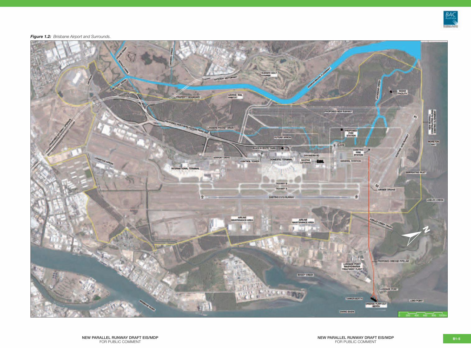
Figure 1.2: Brisbane Airport and Surrounds
Figure 1.4a: Dredge Mooring and Pipeline Options
Figure 1.4b: Location of Boreholes and Seismic Information around the Mouth of the Brisbane River
Figure 1.4c: Stratigraphic Transect for Geotechnical Investigations Undertaken at the Mouth of the Brisbane River
Tables
Table 1.2: Development Activities Associatedwith the New Parallel Runway and Their Purpose
Table 1.4a: Investigations Undertaken in Relation to the Dredge Mooring and Pipeline Alignment
Table 1.4b: Summary of Key Environmental and Social Impact Issues Considered in Selecting the Dredge Pump-out Location and Pipeline Alignment
NEW PARALLEL RUNWAY DRAFT EIS/MDPFOR PUBLIC COMMENTB1-2

1.1 Introduction
This Volume of the Draft EIS/MDP reports on ‘ground level’ aspects of the project, assessing impacts on Airport land, its fringes and surrounding areas, as well as socio-economic impacts. The Volume includes the following Chapters:
B2: Land Use and Planning
B3: Geology, Soils and Groundwater
B4: Coastal Processes and Natural Features
B5: Terrestrial and Marine Ecology
B6: Cultural Heritage
B7: Surface Hydrology
B8: Water Quality
B9: Social Impact Assessment
B10: Surface Transport
B11: Construction and Traffic Noise
B12: Construction and Traffic Air Emissions
B13: Landscape and Visual
The Volume concludes (B14) with a draft Environmental Management Framework (EMF) that summarises the best practice management strategies, measures and monitoring requirements that are proposed to be applied to the project as it relates to the key subject areas.
A final EMF will be prepared at the conclusion of the EIS/MDP process, taking into account public and agency comments on the Draft EIS/MDP.
The final EMF will:
• Be part of BAC’s tender documentation for selecting construction contractors;
• Provide the framework for the preparation of a range of Environmental Management Plans (EMPs) for each stage of construction that will be developed by construction contractors prior to the commencement of the work [EMP (Construction)]; and
• Inform more detailed approval requirements under the Airports Act 1996 and Queensland legislation that will need to be obtained prior to commencement of works.
1.2 Scope of Airport and Surrounds Section
1.2.1 Location of the Airport
Brisbane Airport (Airport) occupies Commonwealth land held under long term lease by the Brisbane Airport Corporation (BAC) and is situated on the coast, north-east of Brisbane City. As well as managing the operations of Brisbane Airport, BAC controls the Airport’s large 2,700 hectare site that includes a range of aviation-related and commercial activities.
The Airport is zoned Special Purpose Centre under the Brisbane City Council Planning Scheme which specifically recognises its past and expected ongoing use.
Figure 1.2 shows the Brisbane Airport site in relation to its surrounds and shows the names of local natural features such as rivers and creeks used throughout this section. The figure also shows existing built features on Airport land including the NPR layout and other major infrastructure projects proposed in the local region such as the Gateway Upgrade Project (GUP).
Within the environs of the Airport, the area immediately to the west comprises open space along Kedron Brook Floodway, the southern extent of the Boondall Wetlands and parts of the suburbs of Nudgee Beach, Banyo and Northgate used for residential purposes (low to medium density), local commercial uses and community facilities, special purposes and some industrial activities (light to medium).
The northern boundary of the Airport site is the foreshore of Bramble Bay which is part of the Moreton Bay Marine Park.
On the northern bank of the Brisbane River, immediately adjacent to and east of the Airport, land use is primarily industrial with some remnant pockets and individual parcels of land used for single unit (dwelling house) residential purposes, principally in the suburb of Pinkenba. Industrial use throughout this part of the City (between the Airport and the River) includes light industries and warehousing, medium to high level manufacturing plants and noxious/hazardous industries such as the BP oil refinery at Bulwer Island.
NEW PARALLEL RUNWAY DRAFT EIS/MDP FOR PUBLIC COMMENT
VOLUME B: AIRPORT AND SURROUNDS
Context and Project DescriptionB1
B1-3

The Brisbane City Council’s Luggage Point Wastewater Treatment Plant is located at the northern edge of the suburb of Pinkenba at Luggage Point, adjacent to a large inter-tidal mangrove and saltmarsh area known as Juno Point.
The southern boundary of the Airport is bounded by the Gateway Motorway, the Trade Coast Central site, and the suburbs of Eagle Farm, Doomben, Hendra, and Toombul, which all contain a mix of residential, commercial and industrial land uses.
1.2.2 Development Activities Relevant to Airport and Surrounds
As described in Chapters A4 and A5 of the Draft EIS/MDP, in addition to the construction of the
permanent works such as the new runway and airfield drainage system there will be a range of temporary development activities occurring within and adjacent to the Airport site, primarily associated with the dredging and reclamation process.
Table 1.2 summarises the development activities proposed as part of the NPR project on the Airport and in the surrounding area. To assist in understanding the different development components, the table indicates the primary purpose of the construction works in the context of the larger project and whether the works are temporary or permanent. A full description of these works, including design drawings, is contained in Chapters A4 and A5 of the Draft EIS/MDP.
Table 1.2: Development Activities Associated with the NPR and Their Purpose.
Development Activity Purpose DurationConstruction of a mooring in the vicinity of the Luggage Point.
Allows the dredge vessel operating at Middle Banks to moor and pump-out the collected sand from Middle Banks to the Airport site where the new runway is to be constructed.
Temporary
Construction of a dredge pipeline and associated maintenance road from the mooring to the Airport site.
The pipeline conveys the sand (in a water-sand slurry) from the dredge vessel to the areas required to be filled for the new runway on Airport.
The maintenance road is required for establishment, monitoring and maintenance of the pipeline whilst in operation.
Temporary
Construction of two tidal discharge channels one into Kedron Brook Floodway and the other into Serpentine Inlet (Bramble Bay).
The drainage channels will convey tailwater (associated with the dredge operation) and stormwater off the Airport site during construction and operational phases of the project.
Permanent
Construction of a seawall along a portion of the northern coastline of the Airport site.
To protect the existing and new runway system from erosion from the sea particularly in storm events.
Permanent
Construction of an approach lighting structure extending into Bramble Bay.
To provide approach lighting to aircraft landing on the new runway when operating over Moreton Bay.
Permanent
Construction of bunds and embankments to prevent run-off from the site during construction.
Removing Casuarina and mangrove vegetation contained within the new runway footprint.
To prepare the site for receiving the dredged sand from Middle Banks, Moreton Bay.
Temporary
Permanent
Filling of land and waterways for the new runway.
To fill the ground area where the new runway and associated facilities are proposed.
A range of ground treatment methods (e.g. surcharge, wick drains) will be implemented to ensure that the site settles uniformly prior to commencing the civil works stage.
Permanent
Construction of the runway, taxiways, associated aviation facilities, access roads and stormwater drainage infrastructure.
This final stage of civil works will facilitate the opening of the runway for air traffic.
Permanent
NEW PARALLEL RUNWAY DRAFT EIS/MDP FOR PUBLIC COMMENTB1-4
NEW PARALLEL RUNWAY DRAFT EIS/MDPFOR PUBLIC COMMENT
NEW PARALLEL RUNWAY DRAFT EIS/MDPFOR PUBLIC COMMENT
B1-5
Figure 1.2: Brisbane Airport and Surrounds.
N
0 200 400 600 800 1000m

Figure 1.4a: Dredge Mooring and Pipeline Options.
N
NEW PARALLEL RUNWAY DRAFT EIS/MDPFOR PUBLIC COMMENT
NEW PARALLEL RUNWAY DRAFT EIS/MDPFOR PUBLIC COMMENT
B1-6

1.3 Chapter Layout
Each Chapter within Volume B Airport and Surrounds will include or address the following matters:
1) An introduction, defining the meaning and scope of the environmental or socio-economic issue (e.g. noise, water quality, etc.) that is the subject of the Chapter;
2) A discussion of the development activities (outlined in Table 1.2) of the project that are relevant to the assessment for that particular issue;
3) The methodology, where relevant, used in describing the baseline (current) condition and impact assessment;
4) Limitations and assumptions, if any, made in relation to the assessment;
5) A description of the baseline conditions relevant to the issue and the project;
6) Any specific or noteworthy consultation undertaken as part of the baseline and impact assessment process prior to release of the Draft EIS/MDP for public comment;
7) The key or relevant laws, policies and guidelines for the issue that were considered as part of the assessment;
8) An assessment of potential impacts of the project for the issue;
9) An assessment of any cumulative impacts and/or interactive effects;
10) Discussion about mitigation measures that could be employed to reduce or ameliorate impacts;
11) Discussion about residual effects following consideration of mitigation measures;
12) An assessment summary matrix that summarises the key findings of the Chapter in terms of potential impacts.
The Chapters of this section of the Draft EIS/MDP should be read together in the context of identifying the key environmental and socio-economic issues relevant to the NPR project on the Airport and in surrounding environs.
1.4 Dredge Pump-out and Pipeline Alignment
1.4.1 Introduction
As discussed in Chapter A4 of the Draft EIS/MDP,several locations in the Brisbane River were investigated as part of the preliminary design for the dredge mooring facility. Associated with the mooring location was a preferred pipeline alignment for the pipeline that would convey the sand (in the form of a sand/water slurry) from the mooring facility onto Airport land and the runway reclamation site.
Both the dredge mooring facility and pipeline are temporary works that would be established for the dredging and reclamation phase of the project and then decommissioned and removed.
The four mooring locations and pipeline alignment options are shown on Figure 1.4a and are described as:
• Boggy Creek;
• Luggage Point;
• Juno Point; and
• Koopa Channel.
As shown in the figure, the Juno Point mooring option has two pipeline alignment sub-options. Juno Point ‘A’ involves a direct pipeline route across the inter-tidal Juno Point area. Juno Point ‘B’ cuts across a smaller area of the inter-tidal Juno Point area and then joins the Luggage Point pipeline alignment near the Luggage Point Wastewater Treatment Plant.
NEW PARALLEL RUNWAY DRAFT EIS/MDP FOR PUBLIC COMMENT B1-7

1.4.2 Logistical Issues
The key logistical constraints for selection of a mooring location to accommodate a medium to large class Trailer Suction Hopper Dredge (TSHD) proposed to be used for the dredging and reclamation phase of the project were identified in Chapter A5 as the following:
• Maximum dredge pumping distance between the mooring and the reclamation site is between 6 kmand 7 km;
• Water depth for independent dredge manoeuvring is to be no less than 13 m to 14 m (below LAT);
• Protection from prevailing weather conditions would be an advantage.
The key logistical constraints for selection of a pipeline alignment and corridor were identified as the following:
• The pipeline should be as straight as possible, without too many bends, dips and rises;
• Delivery height does not exceed +10 mchart datum;
• Efficient pipe diameters are used taking into account pump power, grain size and delivery distances; and
• Alignment of the delivery pipeline is through areas with suitable geotechnical conditions to allow maintenance access.
In the context of the Luggage Point option, an additional logistical constraint was that the mooring
location and pipeline alignment would need to be located and able to be operated in a manner that did not adversely impact on the operation of the Luggage Point Wastewater Treatment Plant to the satisfaction of Brisbane Water.
In the context of the Boggy Creek option, an additional logistical constraint was that the mooring location and pipeline alignment would need to be located and able to be operated in a manner that did not adversely impact on the operation of the BP Crude Oil Wharf and Pipeline Facility.
Using these logistical constraints as a starting point, an investigation of the suitability of the mooring sites was undertaken to identify a preferred location.
1.4.3 Investigations Undertaken for Mooring Locations and Pipeline Alignments
The baseline investigation of the suitability of each of the four mooring locations and pipeline alignments was primarily a ‘desktop’ exercise using existing information and data.
However, additional information was required to confirm the engineering, dredge operations, and environmental issues associated with each of the mooring locations and pipeline routes.
Table 1.4a lists and summarises the additional investigations that were undertaken in 2005 and 2006 as part of this process and how the information has been used in assessing the suitability of the four pump-out mooring locations and pipeline alignments.
Table 1.4a: Investigations Undertaken in Relation to the Dredge Mooring and Pipeline Alignment.
Investigation/Study How Information Has Been Used
Fine scale bathymetric surveys involving:
• 25 m line spacing for the Luggage Point, Juno Point and Koopa Channel pump-out locations;
• 5 m line spacing at the rehandling basin at Boggy Creek.
Confirms the water depth at each area to determine the maximum vessel draught that could be accommodated at the location.
Enables the calculation of the amount of material that would need to be dredged to provide a mooring basin (e.g. dredge slot) for a medium to large class dredge vessel at that proposed mooring location.
Sub-bottom profiling through seismic surveys to determine underlying geologic layers (refer Figure 1.4b).
To target locations for further investigations by marine vibro-coring techniques to ground truth the sub-bottom reflector and determine actual geologic material.
In particular, the survey sought to identify key geological features such as stiff clays associated with older Pleistocene sediments that would be underlying more recently deposited silt and mud layers at the surface.
NEW PARALLEL RUNWAY DRAFT EIS/MDP FOR PUBLIC COMMENTB1-8

Investigation/Study How Information Has Been Used
Nearshore geotechnical sampling using continuous marine vibro-coring.
Nine boreholes were selected based on the seismic data with boreholes at each of the proposed mooring locations.
A conceptual diagram showing the stratigraphic transect obtained from these boreholes is contained in Figure 1.4c.
Identify the physical characteristics (e.g. grain size, silt/mud content) of the in situ material in the context of potential capital dredging and spoil disposal.
Identify the geotechnical characteristics of underlying marine sediment to determine resistance to marine piling (associated with the construction of the mooring jetty).
Obtain sediment samples for laboratory analysis to assess the acid sulfate potential of the in situ material.
Obtain sediment samples for laboratory analysis of sediment quality including the presence of contaminants such as heavy metals and pathogens in the in situ material.
Confirm the levels of geologic reflectors such as the Pleistocene horizon as interpreted from the seismic surveys.
Magnetometer surveys of the old rehandling basin at Boggy Creek to identify the presence of any solid waste material buried in the sediment.
Identification of any solid waste material that would need to be removed from the rehandling basin prior to dredging.
Field assessments along each pipeline alignment. Identify ground conditions along each pipeline route (for placement of the pipeline and maintenance track).
Identify specific engineering and/or aviation constraints that would need to be addressed along the pipeline route (for example, the need for a trestle structure to allow the pipeline to cross over the Luggage Point Wastewater Treatment Plant Outfall).
Baseline flora assessments conducted in habitats along the proposed pipeline alignments.
To verify existing reporting and spatial data and to describe current habitat condition and composition. Data collected included location, environmental and overall vegetation structural information as well as a list of dominant species present.
1.4.4 Comparison of Options
Based on the information obtained from the investigations outlined above, the environmental and social issues that were seen as the key issues in the context of a comparative analysis between mooring and pipeline alignment alternatives were as follows:
1. Impacts on terrestrial ecology (principally the wader bird roosting and feeding sites known to occur at and around Juno Point).
2. Impacts on marine ecology (principally the direct and indirect impact to mangroves and other marine plants located at and around Juno Point).
3. Impacts on water quality (associated with the need to undertake capital dredging of mooring basins and disposal of the resultant dredge spoil).
4. Impacts on conservation areas or zones identified as having importance or significance in marine and coastal plans and strategies.
5. Noise impacts from operation of the vessel at each of the proposed pump-out locations.
6. Social impacts on existing uses in the area that could result from construction and operation of the mooring and pipeline alignment.
7. Visual and landscape impacts from the mooring facility and pipeline alignment.
A summary of the potential impacts for the key issues of each option is contained in Table 1.4b.
For comparative purposes, impacts identified in the table are categorised as Major, Moderate, Minor or Negligible.
NEW PARALLEL RUNWAY DRAFT EIS/MDP FOR PUBLIC COMMENT B1-9

1.4.5 Preferred Option – Luggage Point
As illustrated in Table 1.4b, identification of a preferred option is a balance between the attributes of the mooring location and associated pipeline route.
The analysis in the table shows that Luggage Point is identified as the clear preferred option.
The advantages of this location in the context of the key issues outlined in the table are as follows:
• The pipeline route from this location to the reclamation site avoids ecologically important areas within and adjacent to Juno Point for wader birds.
• No clearing or trimming of mangroves is required except mangroves fringing the Jubilee Creek Drain that will be restored following completion of the dredge pump-out activity.
• No capital dredging would be required to establish a mooring basin which will avoid water quality impacts from dredging and spoil disposal.
• The mooring location and pipeline is not located in the Moreton Bay Ramsar Site or the Moreton Bay Marine Park and avoids areas identified as having conservation significance under the South East Queensland Regional Plan 2005 and South East Queensland Regional Coastal Management Plan 2006.
• No noise impacts are anticipated from operation of the dredge at the Luggage Point mooring location.
• The construction of the mooring facility and pipeline are temporary and not expected to impact on land-based commercial or recreational uses and activities in the area.
• Based on preliminary consultation with peak commercial fishing bodies, all four of the proposed dredge mooring options are situated within an area presently used by beam trawling operators. However, Luggage Point is preferred to the two offshore sites (Koopa Channel and Juno Point) on the basis that the two offshore sites are seen by the fishing groups consulted as more significant for fisheries habitat and these areas are important for the net fishery based on tailor.
• There are negligible visual or landscape impacts from the location and pipeline alignment as it crosses industrial land behind the Luggage Point Wastewater Treatment Plant.
This analysis supports the logistical advantages of the Luggage Point site which are as follows:
• The pipeline route from this location to the reclamation site is the most direct (straightest and shortest) of the options and does not require a booster pumping station.
• The pipeline alignment has suitable ground conditions for the pipeline and maintenance access track.
• The mooring location is a relatively sheltered site.
Accordingly, the Chapters in Volume B Airport and Surrounds of the Draft EIS/MDP have identified Luggage Point as the preferred mooring location and pipeline alignment. Within each Chapter, the discussion of potential impacts from construction and operation of the dredge mooring facility and pipeline alignment is centred on this option.
NEW PARALLEL RUNWAY DRAFT EIS/MDP FOR PUBLIC COMMENTB1-10

514000
514200
514400
514600
514800
515000
515200
515400
515600
515800
516000
516200
516400
516600
516800
517000
517200
517400
517600
Easting
514000
514200
514400
514600
514800
515000
515200
515400
515600
515800
516000
516200
516400
516600
516800
517000
517200
517400
517600
6971200
6971400
6971600
6971800
6972000
6972200
6972400
6972600
6972800
6973000
6973200
6973400
6973600
6973800
6974000
6974200
6974400
6974600
6974800
6975000
6975200
6975400
6975600
6975800
6976000
6976200
6976400
6976600
6971200
6971400
6971600
6971800
6972000
6972200
6972400
6972600
6972800
6973000
6973200
6973400
6973600
6973800
6974000
6974200
6974400
6974600
6974800
6975000
6975200
6975400
6975600
6975800
6976000
6976200
6976400
6976600
Northing
GC17
GC18
GC20
GC22
GC23
GC1
GC2
-4
GC1
Key:
Sea Floor Levels m LAT
Interpreted Reflector Levels m LAT
Vibrocore Location
Possible Gas Charged Sediments
Possible Gas Charged Sediments
Possible Gas Charged Sediments
Possible Gas Charged Sediments
Shipping Channel
Koopa Channel
Koopa Channel
-25m-24m-23m-22m-21m-20m-19m-18m-17m-16m-15m-14m-13m-12m-11m-10m-9m-8m-7m-6m-5m-4m-3m-2m-1m0m1m
Red
uced
Leve
l(m
)LA
T
Luggage Point Boreholes Juno Point Boreholes
Koopa Channel Boreholes
Figure 1.4b: Location of Boreholes and Seismic Information Around the Mouth of the Brisbane River.
NEW PARALLEL RUNWAY DRAFT EIS/MDPFOR PUBLIC COMMENT
NEW PARALLEL RUNWAY DRAFT EIS/MDPFOR PUBLIC COMMENT
B1-11

Figure 1.4c: Stratigraphic Transect for Geotechnical Investigations Undertaken at the Mouth of the Brisbane River.
NEW PARALLEL RUNWAY DRAFT EIS/MDPFOR PUBLIC COMMENT
NEW PARALLEL RUNWAY DRAFT EIS/MDPFOR PUBLIC COMMENT
B1-12
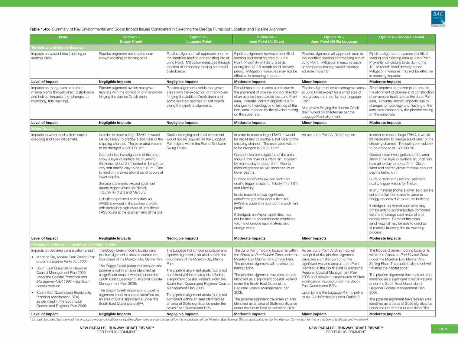
Table 1.4b: Summary of Key Environmental and Social Impact Issues Considered in Selecting the Dredge Pump-out Location and Pipeline Alignment.
Issue Option 1 –Boggy Creek
Option 2 –Luggage Point
Option 3a –Juno Point (A) Direct
Option 3b –Juno Point (B) Via Luggage
Option 4 – Koopa Channel
Terrestrial and Marine Ecology
Impacts on wader birds (roosting or feeding sites).
Pipeline alignment not located near known roosting or feeding sites.
Pipeline alignment will approach near to the identified feeding and roosting site at Juno Point. Mitigation measures through erection of temporary fencing can avoid disturbance.
Pipeline alignment traverses identified feeding and roosting area at Juno Point. Proximity will disturb birds during the 12-18 month sand delivery period. Mitigation measures may not be effective in reducing impacts.
Pipeline alignment will approach near to the identified feeding and roosting site at Juno Point. Mitigation measures such as temporary fencing would minimise adverse impacts.
Pipeline alignment traverses identified feeding and roosting area at Juno Point. Proximity will disturb birds during the 12–18 month sand delivery period. Mitigation measures may not be effective in reducing impacts.
Level of Impact Negligible Impacts Negligible Impacts Moderate Impacts Minor Impacts Moderate Impacts
Impacts on mangroves and other marine plants through direct disturbance and indirect impacts (e.g. changes to hydrology, tidal flushing).
Pipeline alignment avoids mangrove habitats with the exception of mangroves fringing the Jubilee Creek drain.
Pipeline alignment avoids mangrove areas with the exception of mangroves fringing the Jubilee Creek drain and some isolated patches of salt couch along the pipeline alignment.
Direct impacts on marine plants due to the alignment of pipeline and construction of an access track across the Juno Point area. Potential indirect impacts due to changes to hydrology and flushing of the local area imposed by the pipeline resting on the substrate.
Pipeline alignment avoids mangrove areas at Juno Point except for a small area of mangroves and mud flat near Luggage Point.
Mangroves fringing the Jubilee Creek drain would be affected as per the Luggage Point alignment.
Direct impacts on marine plants due to the alignment of pipeline and construction of an access track across the Juno Point area. Potential indirect impacts due to changes to hydrology and flushing of the local area imposed by the pipeline resting on the substrate.
Level of Impact Negligible Impacts Negligible Impacts Moderate Impacts Minor Impacts Moderate Impacts
Water Quality
Impacts to water quality from capital dredging and spoil placement.
In order to moor a large TSHD, it would be necessary to dredge a slot clear of the shipping channel. The estimated volume to be dredged is 250,000 m3.
Geotechnical investigations of the area show a layer of surface silt of varying thickness (about 2 m) underlain by soft to very soft marine clay to about 10 m. Fine to medium grained alluvial sand occurs at lower depths.
Surface sediments exceed sediment quality trigger values for Nickel,Tributyl-Tin (TBT) and Mercury.
Unbuffered potential acid sulfate soil (PASS) is evident in the sediment profile with particularly high levels of unbuffered PASS found at the southern end of the site.
Capital dredging and spoil placement would not be required as the Luggage Point site is within the Port of Brisbane Swing Basin.
In order to moor a large TSHD, it would be necessary to dredge a slot clear of the shipping channel. The estimated volume to be dredged is 220,000 m3.
Geotechnical investigations of the area show a thin layer of surface silt underlain by marine clay to about 8 m. Fine to medium grained alluvial sand occurs at lower depths.
Surface sediments exceed sediment quality trigger values for Tributyl-Tin (TBT) and Mercury.
In situ material shows significant, unbuffered potential acid sulfate soil (PASS) is evident throughout the sediment profile.
If dredged, on-Airport spoil sites may not be able to accommodate combined volume of dredge spoil material and dredge water.
As per Juno Point A (Direct) option. In order to moor a large TSHD, it would be necessary to dredge a slot clear of the shipping channel. The estimated volume to be dredged is 130,000 m3.
Geotechnical investigations of the area show a thin layer of surface silt underlain by marine clay to about 6 m. Clean sand and coarse gravel material occur at depths below 6 m.
Surface sediments exceed sediment quality trigger values for Nickel.
In situ material shows a lower acid sulfate soil potential (compared to Juno or Boggy options) due to natural buffering.
If dredged, on-Airport spoil sites may not be able to accommodate combined volume of dredge spoil material and dredge water. Some of the clean sand material may be able to used as fill material following the de-watering process.
Level of Impact Negligible Impacts Negligible Impacts Moderate Impacts Minor Impacts Moderate Impacts
Planning (marine and coastal conservation areas)
Impacts on declared conservation areas1:
• Moreton Bay Marine Park Zoning Plan under the Marine Parks Act 2004.
• South East Queensland Regional Coastal Management Plan 2006 under the Coastal Protection and Management Act 1995 – significant coastal wetland.
• South East Queensland Biodiversity Planning Assessment (BPA) as identified in the South East Queensland Regional Plan 2005.
The Boggy Creek mooring location and pipeline alignment is situated outside the boundaries of the Moreton Bay Marine Park.
The Boggy Creek pump-out location and pipeline is not in an area identified as a significant coastal wetland under the South East Queensland Regional Coastal Management Plan 2006.
The Boggy Creek mooring and pipeline alignment is not in an area identified as an area of State significance under the South East Queensland BPA.
The Luggage Point mooring location and pipeline alignment is situated outside the boundaries of the Moreton Bay Marine Park.
The pipeline alignment abuts (but is not contained within) an area identified as a significant coastal wetland under the South East Queensland Regional Coastal Management Plan 2006.
The pipeline alignment abuts (but is not contained within) an area identified as an area of State significance under the South East Queensland BPA.
The Juno Point mooring location is within the Airport to Port Habitat Zone under the Moreton Bay Marine Park Zoning Plan. The pipeline alignment will traverse the habitat zone.
The pipeline alignment traverses an area identified as a significant coastal wetland under the South East Queensland Regional Coastal Management Plan 2006.
The pipeline alignment traverses an area identified as an area of State significance under the South East Queensland BPA.
As per Juno Point A (Direct) option except that the pipeline alignment traverses a smaller portion of the significant wetland area at Juno Point identified in the South East Queensland Regional Coastal Management Plan 2006 and likewise a smaller area of State significance mapped under the South East Queensland BPA.
Upon joining the Luggage Point pipeline route, see information under Option 2.
The Koopa channel mooring location is within the Airport to Port Habitat Zoneunder the Moreton Bay Marine Park Zoning Plan. The pipeline alignment will traverse the habitat zone.
The pipeline alignment traverses an area identified as a significant coastal wetland under the South East Queensland Regional Coastal Management Plan 2006.
The pipeline alignment traverses an area identified as an area of State significance under the South East Queensland BPA.
Level of Impact Negligible Impacts Negligible Impacts Moderate Impacts Minor Impacts Moderate Impacts1 It should be noted that none of the proposed mooring locations or pipeline alignments are contained within the boundaries of the Moreton Bay Ramsar Site as designated under the Ramsar Convention for the protection of wetlands and waterfowl.
NEW PARALLEL RUNWAY DRAFT EIS/MDPFOR PUBLIC COMMENT
NEW PARALLEL RUNWAY DRAFT EIS/MDPFOR PUBLIC COMMENT
B1-13

Issue Option 1 –Boggy Creek
Option 2 –Luggage Point
Option 3a –Juno Point (A) Direct
Option 3b –Juno Point (B) Via Luggage
Option 4 – Koopa Channel
Noise
Noise impacts (pump-out operation of the vessel at the mooring facility).
Noise from the operation of the vessel during the pump-out operation would be part of the background noise from the operation of the oil pipeline facility and the Port of Brisbane.
Possible noise impacts (as this is the closest option to residences) would need to be confirmed by further noise modelling.
Noise from the operation of the vessel would be part of the background noise from the operation of the oil pipeline facility, the Luggage Point Wastewater Treatment Plant and the Port of Brisbane.
Based on noise monitoring data as discussed in Chapter B11, noise from the dredge conducting pump-out operations at Luggage Point represents a relatively minor contribution to total noise levels at any residence in the local area and is in compliance with day, evening and night time noise standards.
Noise from the operation of the vessel would be part of the background noise from the operation of the Port of Brisbane.
No noise impacts would be expected given the distance to the nearest residences and background noise levels.
As per Juno Point (Direct) Option. Noise from the operation of the vessel would be part of the background noise from the operation of the Port of Brisbane.
No noise impacts would be expected given the distance to the nearest residences and background noise levels.
Level of Impact Negligible Impacts Negligible Impacts Moderate Impacts Minor Impacts Moderate Impacts
Social impacts
Impacts on other existing uses of the area.
Pre-lodgement consultation with the Queensland Seafood Industry Association (QSIA) and the Moreton Bay Seafood Industry Association (MBSIA) identified concerns regarding loss of access for beam trawlers from the proposed pump-out facility during its operation (12–18 months). All four of the proposed dredge mooring options are situated within an area presently used by beam trawling operators.
Available logbook data from the Department of Primary Industries and Fisheries are not of a sufficiently detailed spatial scale to ascertain exactly where within the endorsed fishery area vessels fish although advice from QSIA and MBSIA indicates that a significant number of operators currently use the area in the vicinity of the proposed pump-out locations. It is understood that this potential loss of access is exacerbated by factors external to the Airport development, namely, a reduction in area of operation due to fisheries management planning (East Coast Trawl Fishery Management Plan 1999), developments on the Brisbane River in general, and recently a requirement for all vessels to stay 50 m away from all port facilities.
In addition to potential impacts with beam trawlers, it was also advised that the Koopa Channel and Juno Point berth options would affect key fisheries habitat as well as a net fishery based on tailor (Pomatomus saltatrix). Refer Chapter B5 for more detail.
Given the industrial use of the surrounding land, the proximity of the oil tanker berth and the proximity of the Port of Brisbane, the area has a low frequency of land-based recreational use.
Boating and/or fishing would not be prohibited in the proximity of the mooring facility or pipeline with consideration of safe passage of vessels and public safety.
As for Option 1.
Investigations show that the mooring can be constructed immediately adjacent to the swing basin without affecting port operations, maritime navigation or the operation of the BP Crude Oil Wharf.
Given the proximity to the Port of Brisbane, the area has a low frequency of land-based recreational use.
Boating and/or fishing would not be prohibited in the proximity of the mooring facility or pipeline with consideration of safe passage of vessels and public safety.
Given the proximity to the Port of Brisbane, the area has a low frequency of land-based recreational use.
Boating and/or fishing would not be prohibited in the proximity of the mooring facility or pipeline with consideration of safe passage of vessels and public safety.
Given the proximity to the Port of Brisbane, the area has a low frequency of land-based recreational use.
Boating and/or fishing would not be prohibited in the proximity of the mooring facility or pipeline with consideration of safe passage of vessels and public safety.
Level of Impact Minor to Moderate Impacts Minor to Moderate Impacts Minor to Moderate Impacts Minor to Moderate Impacts Minor to Moderate Impacts
Visual/Landscape
Visual impacts and impacts on landscape values.
Mooring would be situated in an area with existing industrial development, particularly the existing BP oil pipeline and mooring facility. Views from the few residences that occur in the area are already impacted by the mooring of the oil tanker and oil pipeline.
There would be some visual impact expected from the dredge pipeline where it crosses land prior to entering Airport land.
Pipeline would be situated in an area with existing industrial development, particularly the Luggage Point Wastewater Treatment Plant.
The few residences in the area are buffered from the operations by distance and intervening land uses.
Some minor visual impact from the pipeline crossing the undeveloped areas of Juno Point.
Presence of the dredge vessel would not be significant due to the proximity of port operations and other similar size vessels mooring at Fisherman Islands.
As per Juno Point (Direct) Option. Some minor visual impact from the pipeline crossing the undeveloped areas of Juno Point.
Presence of the dredge vessel would not be significant due to the proximity of port operations and other similar size vessels mooring at Fisherman Islands.
Level of Impact Negligible to Minor Impacts Negligible Impacts Negligible to Minor Impacts Negligible to Minor Impacts Negligible to Minor Impacts
NEW PARALLEL RUNWAY DRAFT EIS/MDPFOR PUBLIC COMMENT
NEW PARALLEL RUNWAY DRAFT EIS/MDPFOR PUBLIC COMMENT
B1-14