Volume 2
6
Volume: II Section: 1 Page No: 1 Comprehensive CAT Plan of Satluj River Basin Section 1: Introduction Disasters in Context of Himachal Pradesh* 1 : Geologically the Himalayas are considered to be the youngest mountain chain in the world and are still in the building phase. Himalayas were formed about 45 million years ago, when the Indian Plate collided with Eurasian Plate at the rate of 15cm per year. The Indian Plate is still moving northwards today into the Eurasian Plate at the rate of about 2cm per year. As a result of this the Himalayas are rising at the rate of about 5mm per year. This means that the Himalayas are still geologically active. When two plates move sideways against each other (at transform plate boundary), there is tremendous friction, which makes the movement jerky. The plates slip, then stick, as the friction and pressure build up to incredible levels. When the pressure is released suddenly, and the plates jerk apart, the result is an occurrence of an earthquake. For this reason, earthquakes are frequent in the entire Himalayan region. The state of Himachal Pradesh is in the Northwestern Himalayas. It is environmentally fragile and ecologically vulnerable. Natural hazards are a matter of immediate concern to the state of Himachal Pradesh as every year the state experiences the fury of nature in various forms-like earthquakes, cloudburst, flash floods, landslides, snow avalanches droughts etc. The fragile ecology of the mountain state coupled with large variations in physio-climatic conditions has rendered it vulnerable to the vagaries of nature. The incidence of cloudbursts in the last few years is indicative of greater impending disasters ito come in future. landslides and snow avalanches continue to inflict widespread harm and damage to human life as well as property. The roads that are the state’s lifeline are repeatedly damaged, blocked or washed away by one or other acts of nature. The state as a whole is vulnerable to different kinds of disasters, natural as well as man- made in nature. The major natural disasters or hazards which the state has experienced over the years are as follows: Earthquakes Landslides Flash floods Cloud bursts Avalanches Hailstorms/Droughts EARTHQUAKES Himachal Pradesh is in very sensitive seismic zones. It falls in zone V and IV as per the Seismic Zoning Map of India. ( Ref : IS: 1893-1984 Fourth Revision. Earlier there were five seismic zones which have been further narrowed to four zones now. According to the Foreword to the seismic code IS: 1983-1984, the general basis of zoning is as follows: Zone V: Covers the areas liable to seismic intensity IX and above on Modified Mercalli Intensity Scale. This is the most severe seismic zone and is referred to as the Very High Damage Risk Zone. Zone IV: Gives the area liable to MM VIII. This zone is second in severity to zone V. This is referred to as the High Damage Risk Zone. Zone III: The associated intensity is MM VII. This is termed the Moderate Damage Risk Zone. Zone II: The probable intensity is MM VI. This zone is referred to as the Low Damage Risk Zone. 1 Natural Disasters and Climate Change - Himachal SoE
-
Upload
shilpa-gupta -
Category
Documents
-
view
213 -
download
0
description
Volume 2-Introduction
Transcript of Volume 2
Volume: II Section: 1 Page No: 1
Comprehensive CAT Plan of Satluj River Basin
Section 1:
Introduction
Disasters in Context of Himachal Pradesh*1:
Geologically the Himalayas are considered to be the youngest mountain chain in the
world and are still in the building phase. Himalayas were formed about 45 million years
ago, when the Indian Plate collided with Eurasian Plate at the rate of 15cm per year. The
Indian Plate is still moving northwards today into the Eurasian Plate at the rate of about
2cm per year. As a result of this the Himalayas are rising at the rate of about 5mm per
year. This means that the Himalayas are still geologically active. When two plates move
sideways against each other (at transform plate boundary), there is tremendous friction,
which makes the movement jerky. The plates slip, then stick, as the friction and
pressure build up to incredible levels. When the pressure is released suddenly, and the
plates jerk apart, the result is an occurrence of an earthquake. For this reason,
earthquakes are frequent in the entire Himalayan region.
The state of Himachal Pradesh is in the Northwestern Himalayas. It is environmentally
fragile and ecologically vulnerable. Natural hazards are a matter of immediate concern to
the state of Himachal Pradesh as every year the state experiences the fury of nature in
various forms-like earthquakes, cloudburst, flash floods, landslides, snow avalanches
droughts etc. The fragile ecology of the mountain state coupled with large variations in
physio-climatic conditions has rendered it vulnerable to the vagaries of nature. The
incidence of cloudbursts in the last few years is indicative of greater impending disasters
ito come in future. landslides and snow avalanches continue to inflict widespread harm
and damage to human life as well as property. The roads that are the state’s lifeline are
repeatedly damaged, blocked or washed away by one or other acts of nature.
The state as a whole is vulnerable to different kinds of disasters, natural as well as man-
made in nature. The major natural disasters or hazards which the state has experienced
over the years are as follows:
Earthquakes Landslides
Flash floods Cloud bursts
Avalanches Hailstorms/Droughts
EARTHQUAKES
Himachal Pradesh is in very sensitive seismic zones. It falls in zone V and IV as per the
Seismic Zoning Map of India. ( Ref : IS: 1893-1984 Fourth Revision. Earlier there were
five seismic zones which have been further narrowed to four zones now. According to the
Foreword to the seismic code IS: 1983-1984, the general basis of zoning is as follows:
Zone V: Covers the areas liable to seismic intensity IX and above on Modified Mercalli
Intensity Scale. This is the most severe seismic zone and is referred to as the
Very
High Damage Risk Zone.
Zone IV: Gives the area liable to MM VIII. This zone is second in severity to zone V. This is
referred to as the High Damage Risk Zone.
Zone III: The associated intensity is MM VII. This is termed the Moderate Damage Risk
Zone.
Zone II: The probable intensity is MM VI. This zone is referred to as the Low Damage Risk
Zone.
1 Natural Disasters and Climate Change - Himachal SoE

Volume: II Section: 1 Page No: 2
Comprehensive CAT Plan of Satluj River Basin
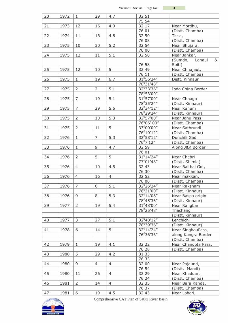
From the perusal of seismic zoning map of Himachal Pradesh (Fig.II) it is seen that 32 %
of the total geographical area is prone to the severest seismic risks as it falls into the
Very High Damage Risk Zone V. It was subjected in 1905 to one of the most giant
earthquakes of the recorded seismic history of India having a magnitude of 8.0 on the
openended Richter Scale in which 20,000 people lost their lives, the towns of Kangra and
Dharamshala were razed to the ground and no government functionary was left alive to
report the happening to the higher authorities. It shook an area of more than 416000
km2 in and around the present Himachal Pradesh. A maximum Intensity X on Rossiforel
Scale was observed in the epicentral area which, when interpreted on the new current
Modified Mercalli Scale, would be between X and XI. There have been 250 earthquakes
of magnitude 4.0 and more including more than sixty earthquakes with magnitude 5.0 or
more, which rocked the state of H.P. and adjoining areas of J&K and Uttranchal Pradesh
in the last 90 years. The Kinnaur earthquake of January 19, 1975 (M=6.7) and the
Dharamshala earthquake of April 26,1986 (M=5.7) are well recorded in respect of
damages caused and loses incurred. A list of earthquakes of M=4.0 or more is given in
Table II which had their epicenters either within or close to the state boundary.
Earthquakes having magnitude 4 or more on the Richter Scale in Himachal Pradesh
during the last 200 years.
S.No Year Month Day Magnitude Coordinates Tentative location
1 1809 - 5.5 30042’00” Near Labrang
780 30’00” (Distt.Kinnaur)
2 1827 9 5.5 32030’00” Near Dalhousie
76000’00” (Distt. Chamba)
3 1856 4 7 5 31000’00” Near Ranhog
77000’00” (Distt.Solan)
4 1858 8 11 5 3107’12” Shimla
77010’12” (Distt.Shimla)
5 1865 4 11 — Shimla region
6 1905 4 4 8 32018’00” Karari Dal
76015’00” (Distt.Kangra)
7 1906 2 28 7 32000’00” Near Karshing
770 00’00” (Distt.Kullu)
8 1930 5 11 5.5 31042’00” Shila Kiepr
77000’00” (Distt. Mandi)
9 1940 4 7 — 31 05 Near kali Hatti
77 00 Distt. Shimla
10 1945 6 22 6.5 32036’00” Minu
75054’00” (Distt. Chamba)
11 1947 7 10 6.2 32036’00” Minu
75054’00” (Distt. Chamba )
12 1950 8 12 5.5 32036’00” Minu
75054’00” (Distt. Chamba)
13 1951 9 22 6.4 32 36 East of Dhan Kanda
76 30 (Distt. Chamba)
14 1962 9 15 5.5 31054’00” Near Dehra Gopipur
76012’00” (Distt.Kangra)
15 1965 2 21 4.5 32 14 Near Bara Banghal,
76 54 (Distt. kangra)
16 1967 9 20 — 32 36 Near Rajpura,
76 06 (Distt. Chamba)
17 1968 5 11 4.9 32 22 Near Atrori,
76 22 (Distt. Chamba)
18 1969 1 23 4 32 14 Near Trilokpur,
76 03 (Distt. Kangra)
19 1970 3 5 4.9 32 24 Near Sani,
76 29 (Distt. Chamba)
Volume: II Section: 1 Page No: 3
Comprehensive CAT Plan of Satluj River Basin
20 1972 1 29 4.7 32 51
75 54
21 1973 12 16 4.9 32 17 Near Mordhu,
76 01 (Distt. Chamba)
22 1974 11 16 4.8 32 50 Tissa,
76 08 (Distt. Chamba)
23 1975 10 30 5.2 32 54 Near Bhujara,
76 00 (Distt. Chamba)
24 1975 12 11 5.1 32 50 Near Jankar,
76 58
(Sumdo, Lahaul &
Spiti)
25 1975 12 10 5 32 49 Near Chhajaut,
76 11 (Distt. Chamba)
26 1975 1 19 6.7 31056’24” Distt. Kinnaur
78031’48”
27 1975 2 2 5.1 32033’36” Indo China Border
78053’00”
28 1975 7 19 5.1 31057’00” Near Chnago
78035’24” (Distt. Kinnaur)
29 1975 7 29 5.5 32034’12” Near Kanum
78029’24” (Distt. Kinnaur)
30 1975 2 10 5.3 32057’00” Near Janu Pass
76006’ 00” (Distt. Chamba)
31 1975 2 11 5 33000’00” Near Sathrundi
76010’12” (Distt. Chamba)
32 1976 1 7 5.3 32058’12” Dunchili Gad
7607’12” (Distt. Chamba)
33 1976 1 9 4.7 32 59 Along J&K Border
76 01
34 1976 2 5 5 31014’24” Near Chebri
77001’48” (Distt. Shimla)
35 1976 4 10 4.5 32 43 Near Balthal Got,
76 30 (Distt. Chamba)
36 1976 4 16 4 32 52 Near makkan,
76 00 (Distt. Chamba)
37 1976 7 6 5.1 32026’24” Near Raksham
78021’00” (Distt. Kinnaur)
38 1976 9 8 5.3 32014’08” Near Baspa origin
78045’36” (Distt. Kinnaur)
39 1977 2 19 5.4 31048’00” Near Rangbar
78025’48” Thachang
(Distt. Kinnaur)
40 1977 3 27 5.1 32040’12” Lenchichi
78039’36” (Distt. Kinnaur)
41 1978 6 14 5 32014’24” Near SinghauPass,
76036’36” along Kangra Border
(Distt. Chamba)
42 1979 1 19 4.1 32 22 Near Chandota Pass,
76 28 (Distt. Chamba)
43 1980 5 29 4.2 31 33
76 33
44 1980 9 4 4 32 00 Near Pajaund,
76 54 (Distt. Mandi)
45 1980 11 26 4 32 29 Near Khaddar,
76 24 (Distt. Chamba)
46 1981 2 14 4 32 35 Near Bara Kanda,
76 37 (Distt. Chamba)
47 1981 6 19 4.5 32 43 Near Lohari,

Volume: II Section: 1 Page No: 4
Comprehensive CAT Plan of Satluj River Basin
76 00 (Distt. Chamba)
48 1981 6 13 5 31049’12” Nalpaya Thach
78027’36” (Distt. Kinnaur)
49 1981 5 28 5.2 31049’48” Barling
78025’48” (Distt. Kinnaur)
50 1982 5 18 4 32 25 Near Chagrauta,
76 24 (Distt. Chamba)
51 1983 2 27 5.3 32036’00” Khadi Thach
78034’12” (Distt. Kinnaur)
52 1983 4 13 4 32 46 Near Tikkri Khas,
76 14 (Distt. Chamba)
53 1985 3 11 4.8 31 15 Near Malaun,
77 00 (Distt. Shimla)
54 1985 12 29 4.9 32 37 Near Theru,
76 06 (Distt. Chamba)
55 1986 4 26 5.5 32019’00” Near Nag Dal
76024’00”
(Boundary of
Distt.Chamba &
Kangra)
56 1987 6 10 4.7 31 55 Near Daton,
76 26 (Distt. Chamba)
57 1987 12 26 4.3 32 07 Near Dewal Khas,
76 41 (Distt. Kangra)
58 1991 6 23 4.6 32 18 Near Gataunda,
76 42 (Distt. Shimla)
59 1992 1 26 4.5 32 16 Near Bhagsu Nath,
76 24 (Distt. Kangra)
60 1992 2 13 4.5 32 37 East of Dhan Kanda,
76 30 (Distt. Chamba)
61 1992 9 6 4.6 32 25 Near Darkund,
76 20 (Distt. Chamba)
62 1996 5 9 4 32 50 Near Kuntka Matha,
76 19 (Distt. Chamba)
63 1996 5 23 4.2 32 42 Near East of Kagal
76 29 Dhar(Distt. Chamba)
64 1996 7 14 4.1 32 37 Near East of Dhan
76 31 Kanda(Dist.Chamba)
65 1996 9 14 4.6 32 49 Near Kala Ka
76 22 Bhandar,
(Distt. Chamba)
66 1997 7 29 4.7 31 33 Near Baldwara,
76 48 (Distt. Mandi)
67 1997 8 13 4.2 31 12 Near Jajjar,
76 41 (Distt. Solan)
68 1998 10 17 4.5 32 12 Near Kandha,
76 32 (Distt. Kangra)
69 1999 5 30 4.9 31 48 36 Near Miyang Lung,
78 54 36 (Distt. Kinnaur)
70 1999 1 8 4.2 31 26 24 Near Mehog,
77 18 00 (Distt. Mandi)
71 1999 5 30 4.9 31 48 36 Near Miyang Lung,
78 54 36 (Distt. Kinnaur)
72 1999 1 8 4.1 31 22 48 Near Karsog,
77 17 24 (Distt. Mandi)
72 2000 4 28 4.1 31 30 36 Near mehbar,
78 15 00 (Distt. kinnaur)
73 2000 8 28 4.5 32 01 48
78 18 00
Volume: II Section: 1 Page No: 5
Comprehensive CAT Plan of Satluj River Basin
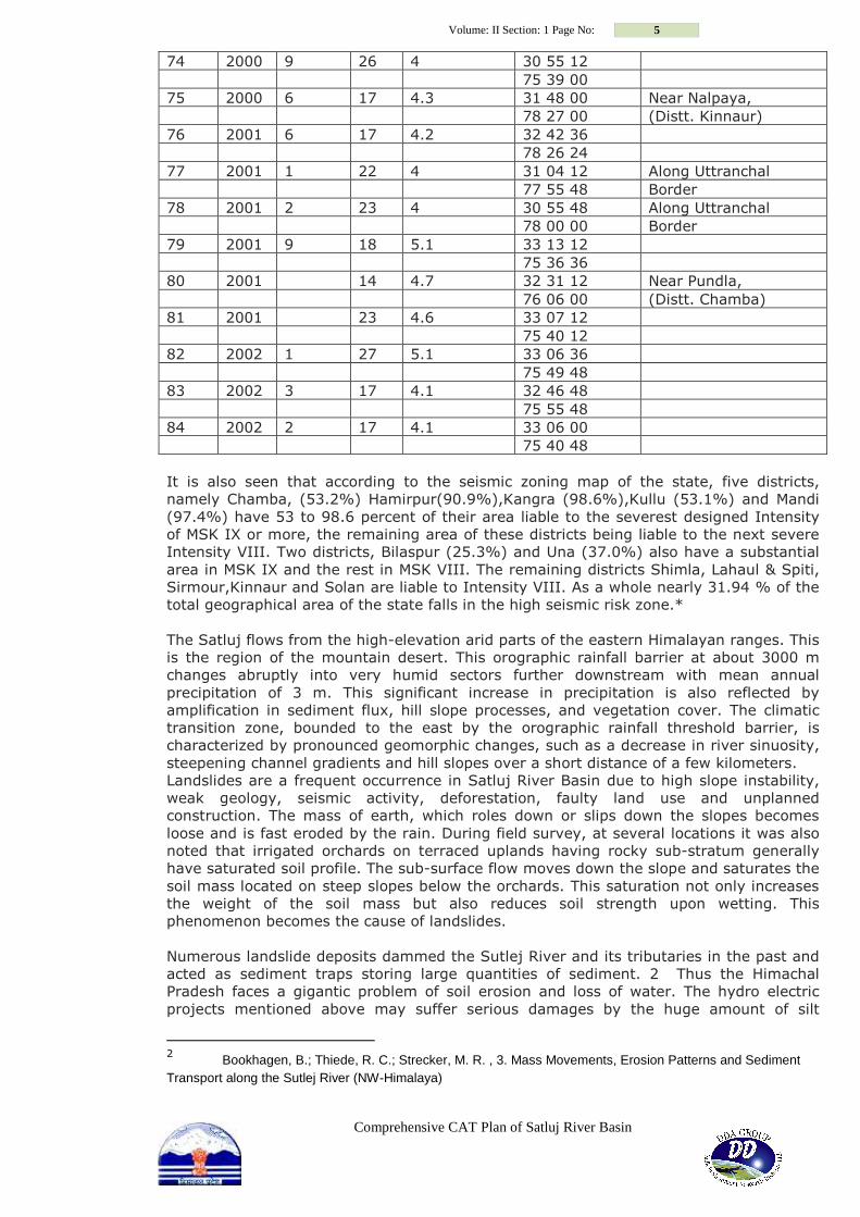
74 2000 9 26 4 30 55 12
75 39 00
75 2000 6 17 4.3 31 48 00 Near Nalpaya,
78 27 00 (Distt. Kinnaur)
76 2001 6 17 4.2 32 42 36
78 26 24
77 2001 1 22 4 31 04 12 Along Uttranchal
77 55 48 Border
78 2001 2 23 4 30 55 48 Along Uttranchal
78 00 00 Border
79 2001 9 18 5.1 33 13 12
75 36 36
80 2001 14 4.7 32 31 12 Near Pundla,
76 06 00 (Distt. Chamba)
81 2001 23 4.6 33 07 12
75 40 12
82 2002 1 27 5.1 33 06 36
75 49 48
83 2002 3 17 4.1 32 46 48
75 55 48
84 2002 2 17 4.1 33 06 00
75 40 48
It is also seen that according to the seismic zoning map of the state, five districts,
namely Chamba, (53.2%) Hamirpur(90.9%),Kangra (98.6%),Kullu (53.1%) and Mandi
(97.4%) have 53 to 98.6 percent of their area liable to the severest designed Intensity
of MSK IX or more, the remaining area of these districts being liable to the next severe
Intensity VIII. Two districts, Bilaspur (25.3%) and Una (37.0%) also have a substantial
area in MSK IX and the rest in MSK VIII. The remaining districts Shimla, Lahaul & Spiti,
Sirmour,Kinnaur and Solan are liable to Intensity VIII. As a whole nearly 31.94 % of the
total geographical area of the state falls in the high seismic risk zone.*
The Satluj flows from the high-elevation arid parts of the eastern Himalayan ranges. This
is the region of the mountain desert. This orographic rainfall barrier at about 3000 m
changes abruptly into very humid sectors further downstream with mean annual
precipitation of 3 m. This significant increase in precipitation is also reflected by
amplification in sediment flux, hill slope processes, and vegetation cover. The climatic
transition zone, bounded to the east by the orographic rainfall threshold barrier, is
characterized by pronounced geomorphic changes, such as a decrease in river sinuosity,
steepening channel gradients and hill slopes over a short distance of a few kilometers.
Landslides are a frequent occurrence in Satluj River Basin due to high slope instability,
weak geology, seismic activity, deforestation, faulty land use and unplanned
construction. The mass of earth, which roles down or slips down the slopes becomes
loose and is fast eroded by the rain. During field survey, at several locations it was also
noted that irrigated orchards on terraced uplands having rocky sub-stratum generally
have saturated soil profile. The sub-surface flow moves down the slope and saturates the
soil mass located on steep slopes below the orchards. This saturation not only increases
the weight of the soil mass but also reduces soil strength upon wetting. This
phenomenon becomes the cause of landslides.
Numerous landslide deposits dammed the Sutlej River and its tributaries in the past and
acted as sediment traps storing large quantities of sediment. 2 Thus the Himachal
Pradesh faces a gigantic problem of soil erosion and loss of water. The hydro electric
projects mentioned above may suffer serious damages by the huge amount of silt
2 Bookhagen, B.; Thiede, R. C.; Strecker, M. R. , 3. Mass Movements, Erosion Patterns and Sediment
Transport along the Sutlej River (NW-Himalaya)
Volume: II Section: 1 Page No: 6
Comprehensive CAT Plan of Satluj River Basin
coming into their turbines and forcing closure for long periods during the peak
generating hours. The silt though directly affects the hydel projects but indirectly causes
many uncountable damages to electricity generation, financial loss, losses to electricity
user and so on. Apart from these, silt load harms the farming lands during monsoon
damages agriculture to the extent that people shift their occupation due to huge losses.
The anthropogenic aspects, geology, soil type, rains and snow are main reasons for
landslides in this region. They cause severe landslides resulting in endangering human
life, loss to biodiversity as well as to infrastructure such as roads and such other
development. These issues can only be handled if we have clear knowledge of the
catchments of the river Satluj and catchments of its tributaries.
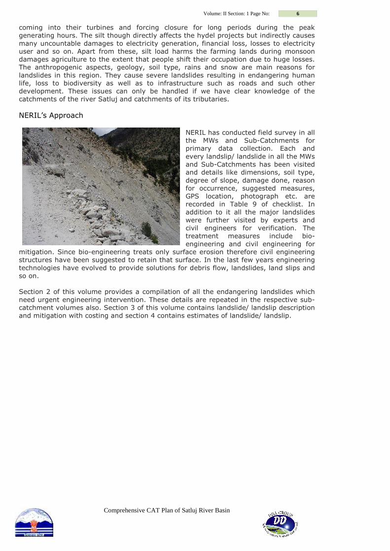
NERIL’s Approach NERIL has conducted field survey in all
the MWs and Sub-Catchments for
primary data collection. Each and
every landslip/ landslide in all the MWs
and Sub-Catchments has been visited
and details like dimensions, soil type,
degree of slope, damage done, reason
for occurrence, suggested measures,
GPS location, photograph etc. are
recorded in Table 9 of checklist. In
addition to it all the major landslides
were further visited by experts and
civil engineers for verification. The
treatment measures include bio-
engineering and civil engineering for
mitigation. Since bio-engineering treats only surface erosion therefore civil engineering
structures have been suggested to retain that surface. In the last few years engineering
technologies have evolved to provide solutions for debris flow, landslides, land slips and
so on.
Section 2 of this volume provides a compilation of all the endangering landslides which
need urgent engineering intervention. These details are repeated in the respective sub-
catchment volumes also. Section 3 of this volume contains landslide/ landslip description
and mitigation with costing and section 4 contains estimates of landslide/ landslip.