Taal volcano NDPTC Volcanic Crises Awareness course, AWR ...
U.S. Department of the InteriorU.S. Geological Survey
USGS Fact Sheet 022–002000
Volcano Hazards of the Lassen Volcanic National ParkArea, California
U.S. GEOLOGICAL SURVEY—REDUCING THE RISK FROM VOLCANO HAZARDS
I
GUS S
n May 1915, Lassen Peak,California, the southern-
most active volcano in the Cas-cade Range, erupted explo-sively. Avalanches, mudflows,and flows of hot ash and gasdevastated nearby areas, andvolcanic ash fell as far away as200 miles to the east. TheLassen area remains volcani-cally active, and the volcanohazards demonstrated in 1915still can threaten not onlynearby areas but also more dis-tant communities. Recent workby scientists with the U.S. Geo-logical Survey (USGS) in coop-eration with the National ParkService is shedding new lighton these hazards.
On the night of May 19, 1915, the few peoplehomesteading outside of Old Station along HatCreek near the foot of Lassen Peak, a volcano innorthern California, went to bed expecting apeaceful night’s sleep. By now they had becomeaccustomed to the sounds of small steam explo-sions coming from the volcano, which had beenintermittently active during the past year. Aroundmidnight, Elmer Sorahan was awakened by hisdog barking furiously and pawing him. Dressingquickly, Elmer went outside, expecting a bear orother animal. Instead, he dimly saw a 12-foot-high wall of muddy water and logs rumblingdown Hat Creek. After running more than amile to warn his downstream neighbors, theHalls, he burst through their front door ex-hausted and shouting “Get out! get out! there’sa flood coming.” Mrs. Hall quickly spread thealarm downstream by telephone, and then thefamily scrambled uphill just before the housewas swept off its foundation.
The next morning residents of the area sawthat a wide swath of the northeast slope ofLassen Peak had been devastated by a huge
avalanche and mudflow triggered by a powerfulexplosion at the volcano’s summit. Fortunately,because of the warnings, no one was killed, butseveral houses along the creek were destroyed.When Lassen Peak erupted again on May 22nd,the area was further devastated by a high-speedflow of hot volcanic ash and gas (called a “pyro-clastic flow”), and the incorporation of snow intothis flow generated new mudflows. Ash from theeruption rose high into the air and wind blew iteastward. Fine ash fell at least as far as 200miles from the volcano. Because of the eruptiveactivity, which continued through 1917, and thearea’s stark volcanic beauty, Lassen Peak andthe area surrounding it were declared a Na-tional Park in 1916.
Volcanic history of the Lassen VolcanicNational Park region
The Lassen region has been volcanicallyactive for about 3 million years. Lassen Peak andnearby volcanic domes are the most recentlyactive parts of the Lassen “volcanic center,”which began to erupt about 600,000 years ago.
From 600,000 to 400,000 years ago, eruptionsbuilt a large conical volcano, often referred to as“Brokeoff Volcano” or “Mount Tehama,” whichwas roughly the size of Mount St. Helens, Wash-ington. Later, this volcano became inactive andwas mostly eroded away, leaving remnants thatinclude Brokeoff Mountain, Mount Conard,Mount Diller, and Diamond Peak.
Subsequent eruptions from the Lassen volca-nic center have formed more than 30 steep-sided, mound-shaped accumulations of volca-nic rock, called “lava domes.” Eruptions about27,000 years ago formed Lassen Peak, one ofthe largest lava domes on Earth. When LassenPeak formed, it looked much like the nearby1,100-year-old Chaos Crags domes, with steepsides covered by angular rock talus. However,from 25,000 to 18,000 years ago, during thelast ice age, Lassen Peak’s shape was signifi-cantly altered by glacial erosion.
Lassen Peak and its neighboring lava domesare not typical, conical “stratovolcanoes” likeMount Shasta or Mount Rainier. Those largevolcanoes were formed by repeated eruptions
The May 22, 1915,explosive eruption ofLassen Peak, Califor-nia, blasted pumiceand rock fragmentshigh into the air. In thisphotograph taken fromthe town of Red Bluff,40 miles west of thevolcano, a huge col-umn of volcanic ashand gas produced bythe eruption rises to aheight of more than30,000 feet. Winds blewvolcanic ash eastwardfrom the column,raining fine ash at leastas far away asWinnemucca, Nevada,200 miles from thevolcano. The ash cloudfrom a similar eruptiontoday would pose aserious hazard to flyingaircraft in the WesternUnited States. (Photoby R.E. Stinson; cour-tesy National ParkService.)
of lava and ash from a central summit vent overtens of thousands of years. The Lassen domefield, in contrast, is an example of a volcanicarea that erupts lava from numerous individualvents, each of which is active for a few years toa few decades and usually does not erupt again.
The composition of the molten rock (magma)that feeds volcanism in the Lassen area rangeswidely in its content of silica (SiO
2). When high-
silica (dacite) magma rises to the Earth’s surface,it can erupt explosively to produce ash cloudsand pyroclastic flows. Dacite magma extrudednonexplosively forms lava domes, because it istoo viscous to flow far away from its source.Low-silica (basalt) magma is more fluid andusually erupts less explosively than dacitemagma. Eruptions of basalt magma typicallyproduce elongate lava flows, as well as buildcinder cones (piles of small frothy lava frag-ments or “cinders”) around volcanic vents.
In the past 50,000 years, at least seven majorepisodes of dacitic volcanism produced lavadomes and pyroclastic deposits in the Lassenarea, and another five episodes produced basalticand andesitic (silica content between basalt anddacite) lava flows. In addition, about 30 smallervolcanoes erupted basaltic lavas in the largerregion surrounding the Lassen volcanic center.
What are the hazardous volcanicprocesses of the Lassen area?
The most common volcanic activity in theLassen Peak region consists of small to moder-ate-sized eruptions that produce basaltic lavaflows and localized ash falls. These eruptionstypically last a few months to a year, but maycontinue for several years. They can covermore than a square mile with lava flows, buildcinder cones as high as 1,000 feet, and blanketmany square miles with ash a few inches toseveral feet deep. Because these eruptions arerelatively nonviolent, they rarely cause humanfatalities.
Basaltic volcanism in the Lassen area occursmainly along chains of vents aligned in a north
or northwest direction, parallel to regionalfaults. Examples include Poison Buttes, Sub-glacial Buttes, Tumble Buttes, the ProspectPeak-Red Cinder area, the east side of the HatCreek Valley and Potato Buttes-Sugarloaf area,and the Red Lake Mountain area. Prolongedbasaltic volcanism at a single site can producea sizeable edifice, like the broad, relatively flat“shield” volcanoes of Prospect Peak andSifford Mountain.
Dacite eruptions in the Lassen area typicallybegin with steam explosions caused by theinteraction of rising magma with ground water.When dacite magma charged with volcanic gasesreaches the surface, it erupts explosively, usuallyas a vertical column of gas and ash that can riseseveral miles into the atmosphere. Heavyfallback of hot ash and rock fragments fromeruption columns may generate highly mobilepyroclastic flows that can rush several milesdown a volcano’s slopes and adjacent valleys.Fallout from the eruption column can blanketareas within a few miles of the vent with a thicklayer of pumice, and high-altitude winds maycarry finer ash tens to hundreds of miles from the
volcano, posing a hazard to flying aircraft, par-ticularly those with jet engines.
After an initial explosive eruption, extrusionof gas-depleted dacite magma commonly formslava domes. Growing lava domes are inherentlyunstable, and collapse of their steep sides oftengenerates pyroclastic flows of lava blocks andash that can travel several miles. Such a se-quence of events is recorded by the depositsrelated to the emplacement of Chaos Cragsdomes between 1,100 and 1,000 years ago.
Interaction of hot pyroclastic flows with snowand ice can generate highly mobile flows of mudand debris (called “lahars”) that may rush downvalleys leading away from a volcano. Because ofthis, active volcanoes that have a significantsnow and ice cover can be particularly danger-ous. The lahars that threatened residents of theLassen area in May 1915 were generated byrelatively small eruptions of Lassen Peak. None-theless, they traveled down creek beds as far as12 miles and released floods that affected valleysfor 30 miles downstream.
What non-eruptive volcano hazards areimportant in the Lassen area?
Additional volcano hazards at Lassen arerockfalls and landslides not directly related toeruptions. Recently erupted volcanic domes areunstable and can collapse, generating small tolarge rockfalls. Approximately 350 years ago,collapse of one of the Chaos Crags domes gener-ated huge rockfalls, creating an area now calledthe Chaos Jumbles. The first and largest of thesetraveled 4 miles downslope and was able toclimb 400 feet up the side of Table Mountain.The trigger for the rockfall is unknown, but itwas most likely a large earthquake. Normalweathering also weakens fractured volcanic rockand contributes to small rockfalls. In the summerof 1994, a rockfall of 13,000 cubic yards (thevolume of about 500 minivans) occurred on thenortheastern flank of Lassen Peak. During peri-ods of extreme rainfall or snow melt, mudflows
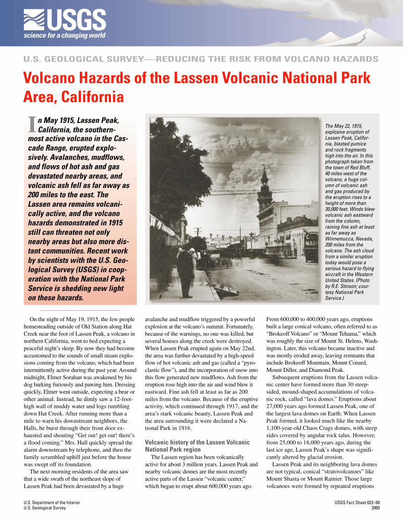
The northeast side of Lassen Peak still shows the scars of its 1914 to 1917 series of eruptions. Thestrongest of these eruptions in May 1915 destroyed a 3-square-mile area, now called the DevastatedArea. Photo at right shows the peak in eruption in October 1915 (photo by Chester Mullen; courtesyNational Park Service).
This twisted stump is all thatremains of a 100-foot-tall red firtree snapped off in Lassen Peak’sMay 1915 eruptions. During theeruptions, high-speed avalanches of hot ash, rock fragments, and gas (pyroclastic flows) and huge mudflowsof volcanic materials and melted snow (lahars) swept down the northeast flank of the volcano, flatteningmany acres of mature forest (see inset photo by Benjamin Loomis; courtesy National Park Service). Someof the lahars traveled more than 12 miles from the volcano, destroying homes along Hat Creek.
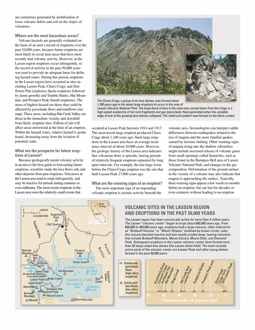
The Lassen region has been volcanically active for more than 3 million years.The Lassen “volcanic center” began to erupt about 600,000 years ago. From600,000 to 400,000 years ago, eruptions built a large volcano, often referred toas “Brokeoff Volcano” or “Mount Tehama” (outlined by brown circle). Later,this volcano became inactive and was mostly eroded away, leaving remnantsthat include Brokeoff Mountain, Mount Conard, Mount Diller, and DiamondPeak. Subsequent eruptions in the Lassen volcanic center have formed morethan 30 steep-sided lava domes (the Lassen dome field). The most recentlyactive parts of the volcanic center are Lassen Peak and other young domesformed in the past 50,000 years.
Cind
er C
one
1915
Lass
en P
eak
Chao
s Cra
gs
Pros
pect
Pea
k are
a
Lass
en P
eak
King
s Cre
ek
Hat M
ount
ain
Sunf
low
er Fl
at
Cres
cent
Cra
ter
Krum
mho
lz Do
me
50 40 30 20 10 0Thousands of years ago
Hat C
reek
flow
Subg
laci
al B
utte
s
Cones and lava flows (low-silica eruptions)
Domes and pyroclastic flows (high-silica eruptions)
Lassen Peak
Red LakeMountain
BrokeoffVolcano
TableMtn
Eagle Peak
Bumpass Hell
Mount Conard
Mount Diller
Diamond PeakBrokeoffMountain
SugarloafPeak
Chaos Crags
Chaos Jumbles
Crescent CraterKrummholz Dome
SunflowerFlat
ProspectPeak
LASSEN VOLCANIC
NATIONAL PARK
Cinder Cone
Red Cinder
Po i s o n
Bu t t e s
Hat Mountain
Sifford Mountain
89
89
44
44
SnagLake
Butte Lake
ManzanitaLake
JuniperLake
Horseshoe Lake
Old Station
to Mineral
Hat C
reek
PotatoButtes
Tumble
Buttes
Kings Creek
SubglacialB
uttes
0
0 4 KILOMETERS
4 MILES
CALIF.
Areaof map
Hat Creekflow
are sometimes generated by mobilization ofloose volcanic debris and soil on the slopes ofvolcanoes.
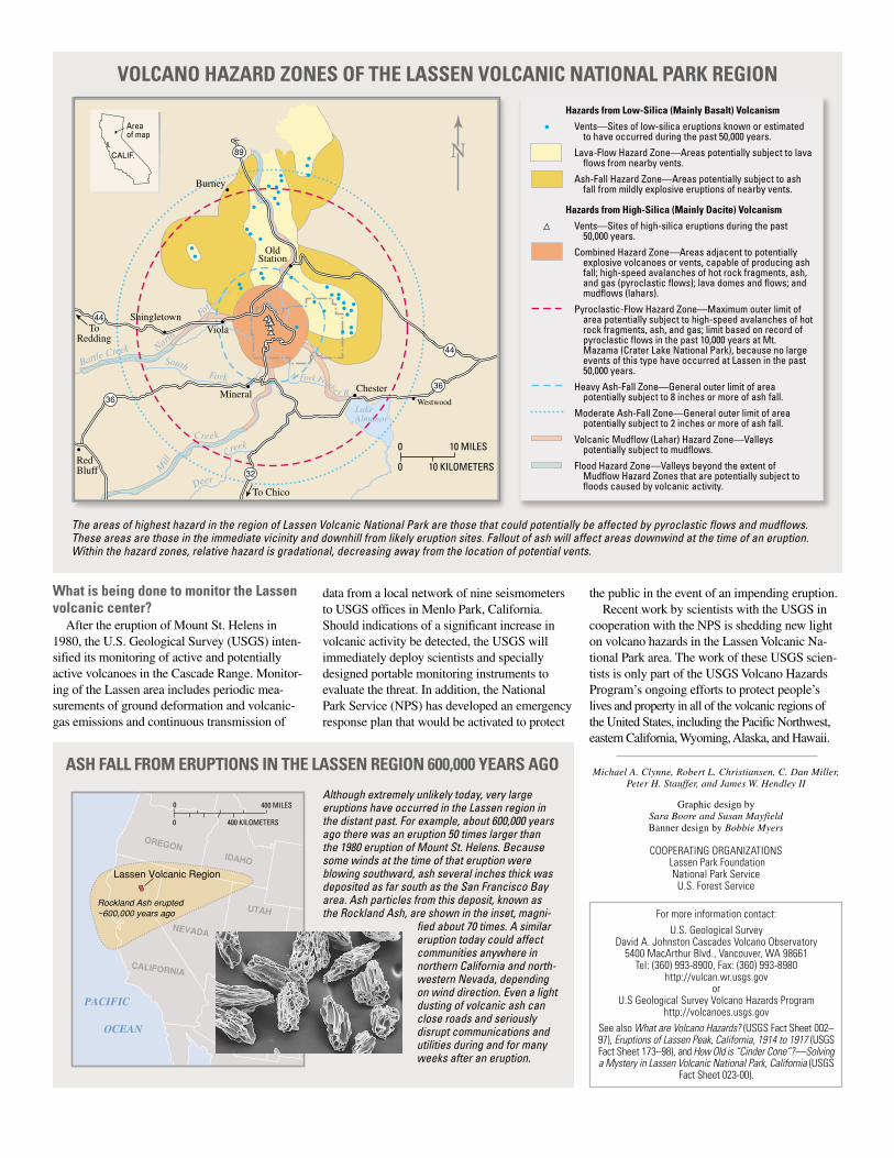
Where are the most hazardous areas?Volcano hazards are generally evaluated on
the basis of an area’s record of eruptions over thepast 10,000 years, because future eruptions aremost likely to occur near areas that have mostrecently had volcanic activity. However, in theLassen region eruptions occur infrequently, sothe record of activity in the past 50,000 yearswas used to provide an adequate basis for defin-ing hazard zones. During this period, eruptionsin the Lassen region have occurred at sites in-cluding Lassen Peak, Chaos Crags, and Sun-flower Flat (explosive dacite eruptions followedby dome growth) and Tumble Buttes, Hat Moun-tain, and Prospect Peak (basalt eruptions). Theareas of highest hazard are those that could beaffected by pyroclastic flows and mudflows (seemap). These areas, including Hat Creek Valley, arethose in the immediate vicinity and downhillfrom likely eruption sites. Fallout of ash willaffect areas downwind at the time of an eruption.Within the hazard zones, relative hazard is grada-tional, decreasing away from the location ofpotential vents.
What are the prospects for future erup-tions at Lassen?
Because geologically recent volcanic activityin an area is the best guide to forecasting futureeruptions, scientists study the lava flows, ash, andother deposits from past eruptions. Volcanoes inthe Lassen area tend to erupt infrequently, andmay be inactive for periods lasting centuries oreven millennia. The most recent eruptions in theLassen area were the relatively small events that
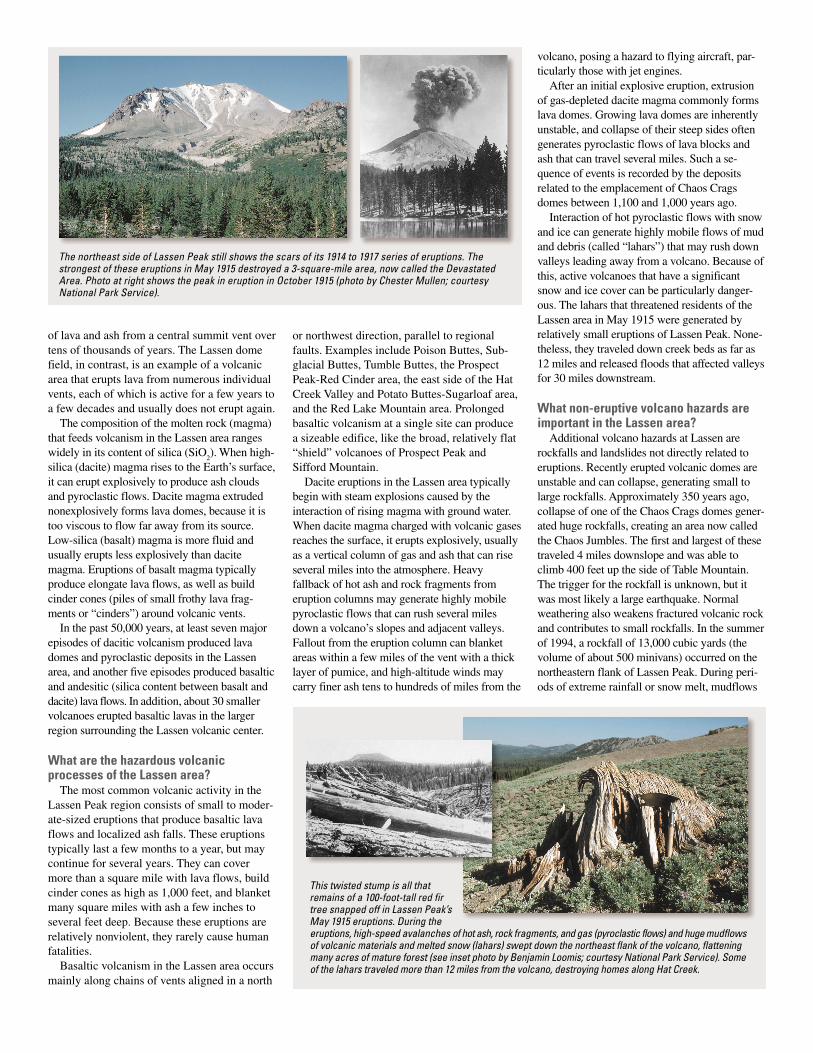
The Chaos Crags, a group of six lava domes, was formed about1,100 years ago in the latest large eruptions to occur in the area of
occurred at Lassen Peak between 1914 and 1917.The most recent large eruption produced ChaosCrags about 1,100 years ago. Such large erup-tions in the Lassen area have an average recur-rence interval of about 10,000 years. However,the geologic history of the Lassen area indicatesthat volcanism there is episodic, having periodsof relatively frequent eruptions separated by longquiet intervals. For example, the last large eventbefore the Chaos Crags eruption was the one thatbuilt Lassen Peak 27,000 years ago.
What are the warning signs of an eruption?The most important sign of an impending
volcanic eruption is seismic activity beneath the
volcanic area. Seismologists can interpret subtledifferences between earthquakes related to therise of magma and the more familiar quakescaused by tectonic faulting. Other warning signsof magma rising into the shallow subsurfacemight include increased release of volcanic gasesfrom small openings called fumaroles, such asthose found in the Bumpass Hell area of LassenVolcanic National Park, and changes in the gascomposition. Deformation of the ground surfacein the vicinity of a volcano may also indicate thatmagma is approaching the surface. Typically,these warning signs appear a few weeks to monthsbefore an eruption, but can last for decades oreven centuries without leading to an eruption.
Lassen Volcanic National Park. The large block of lava in the inset was carried down from the Crags in ahigh-speed avalanche of hot rock fragments and gas (pyroclastic flow) generated when the unstableedge of one of the growing lava domes collapsed. The radial joint pattern was formed as the block cooled.
VOLCANIC SITES IN THE LASSEN REGIONAND ERUPTIONS IN THE PAST 50,000 YEARS
ASH FALL FROM ERUPTIONS IN THE LASSEN REGION 600,000 YEARS AGO
Graphic design bySara Boore and Susan MayfieldBanner design by Bobbie Myers
For more information contact:
U.S. Geological SurveyDavid A. Johnston Cascades Volcano Observatory
5400 MacArthur Blvd., Vancouver, WA 98661Tel: (360) 993-8900, Fax: (360) 993-8980
http://vulcan.wr.usgs.govor
U.S Geological Survey Volcano Hazards Programhttp://volcanoes.usgs.gov
See also What are Volcano Hazards? (USGS Fact Sheet 002–97), Eruptions of Lassen Peak, California, 1914 to 1917 (USGSFact Sheet 173–98), and How Old is “Cinder Cone”?—Solvinga Mystery in Lassen Volcanic National Park, California (USGS
Fact Sheet 023-00).
Michael A. Clynne, Robert L. Christiansen, C. Dan Miller,Peter H. Stauffer, and James W. Hendley II
COOPERATING ORGANIZATIONS Lassen Park Foundation
National Park ServiceU.S. Forest Service
What is being done to monitor the Lassenvolcanic center?
After the eruption of Mount St. Helens in1980, the U.S. Geological Survey (USGS) inten-sified its monitoring of active and potentiallyactive volcanoes in the Cascade Range. Monitor-ing of the Lassen area includes periodic mea-surements of ground deformation and volcanic-gas emissions and continuous transmission of
data from a local network of nine seismometersto USGS offices in Menlo Park, California.Should indications of a significant increase involcanic activity be detected, the USGS willimmediately deploy scientists and speciallydesigned portable monitoring instruments toevaluate the threat. In addition, the NationalPark Service (NPS) has developed an emergencyresponse plan that would be activated to protect
Although extremely unlikely today, very largeeruptions have occurred in the Lassen region inthe distant past. For example, about 600,000 yearsago there was an eruption 50 times larger thanthe 1980 eruption of Mount St. Helens. Becausesome winds at the time of that eruption wereblowing southward, ash several inches thick wasdeposited as far south as the San Francisco Bayarea. Ash particles from this deposit, known asthe Rockland Ash, are shown in the inset, magni-
0
0 400 KILOMETERS
400 MILES
Lassen Volcanic Region
PACIFIC OCEAN
OREGON
IDAHO
UTAH
NEVADA
CALIFORNIA
Rockland Ash erupted~600,000 years ago
fied about 70 times. A similareruption today could affectcommunities anywhere innorthern California and north-western Nevada, dependingon wind direction. Even a lightdusting of volcanic ash canclose roads and seriouslydisrupt communications andutilities during and for manyweeks after an eruption.
89
44
36
44
36
32
CALIF.
Areaof map
ShingletownViola
ChesterWestwood
Burney
Mineral
RedBluff
ToRedding
To Chico
OldStation
M
ill
Creek
Deer
Creek
LakeAlmanor
N Fork Feathe r R
Battle Creek North
Fork
SouthFork
N
0
0 10 KILOMETERS
10 MILES
The areas of highest hazard in the region of Lassen Volcanic National Park are those that could potentially be affected by pyroclastic flows and mudflows.These areas are those in the immediate vicinity and downhill from likely eruption sites. Fallout of ash will affect areas downwind at the time of an eruption.Within the hazard zones, relative hazard is gradational, decreasing away from the location of potential vents.
Hazards from Low-Silica (Mainly Basalt) Volcanism
Vents—Sites of low-silica eruptions known or estimated to have occurred during the past 50,000 years.
Lava-Flow Hazard Zone—Areas potentially subject to lava flows from nearby vents.
Ash-Fall Hazard Zone—Areas potentially subject to ash fall from mildly explosive eruptions of nearby vents.
Hazards from High-Silica (Mainly Dacite) Volcanism
Vents—Sites of high-silica eruptions during the past 50,000 years.
Combined Hazard Zone—Areas adjacent to potentially explosive volcanoes or vents, capable of producing ash fall; high-speed avalanches of hot rock fragments, ash, and gas (pyroclastic flows); lava domes and flows; and mudflows (lahars).
Pyroclastic-Flow Hazard Zone—Maximum outer limit of area potentially subject to high-speed avalanches of hot rock fragments, ash, and gas; limit based on record of pyroclastic flows in the past 10,000 years at Mt. Mazama (Crater Lake National Park), because no large events of this type have occurred at Lassen in the past 50,000 years.
Heavy Ash-Fall Zone—General outer limit of area potentially subject to 8 inches or more of ash fall.
Moderate Ash-Fall Zone—General outer limit of area potentially subject to 2 inches or more of ash fall.
Volcanic Mudflow (Lahar) Hazard Zone—Valleys potentially subject to mudflows.
Flood Hazard Zone—Valleys beyond the extent of Mudflow Hazard Zones that are potentially subject to floods caused by volcanic activity.
the public in the event of an impending eruption.Recent work by scientists with the USGS in
cooperation with the NPS is shedding new lighton volcano hazards in the Lassen Volcanic Na-tional Park area. The work of these USGS scien-tists is only part of the USGS Volcano HazardsProgram’s ongoing efforts to protect people’slives and property in all of the volcanic regions ofthe United States, including the Pacific Northwest,eastern California, Wyoming, Alaska, and Hawaii.
VOLCANO HAZARD ZONES OF THE LASSEN VOLCANIC NATIONAL PARK REGION