Volcano
6
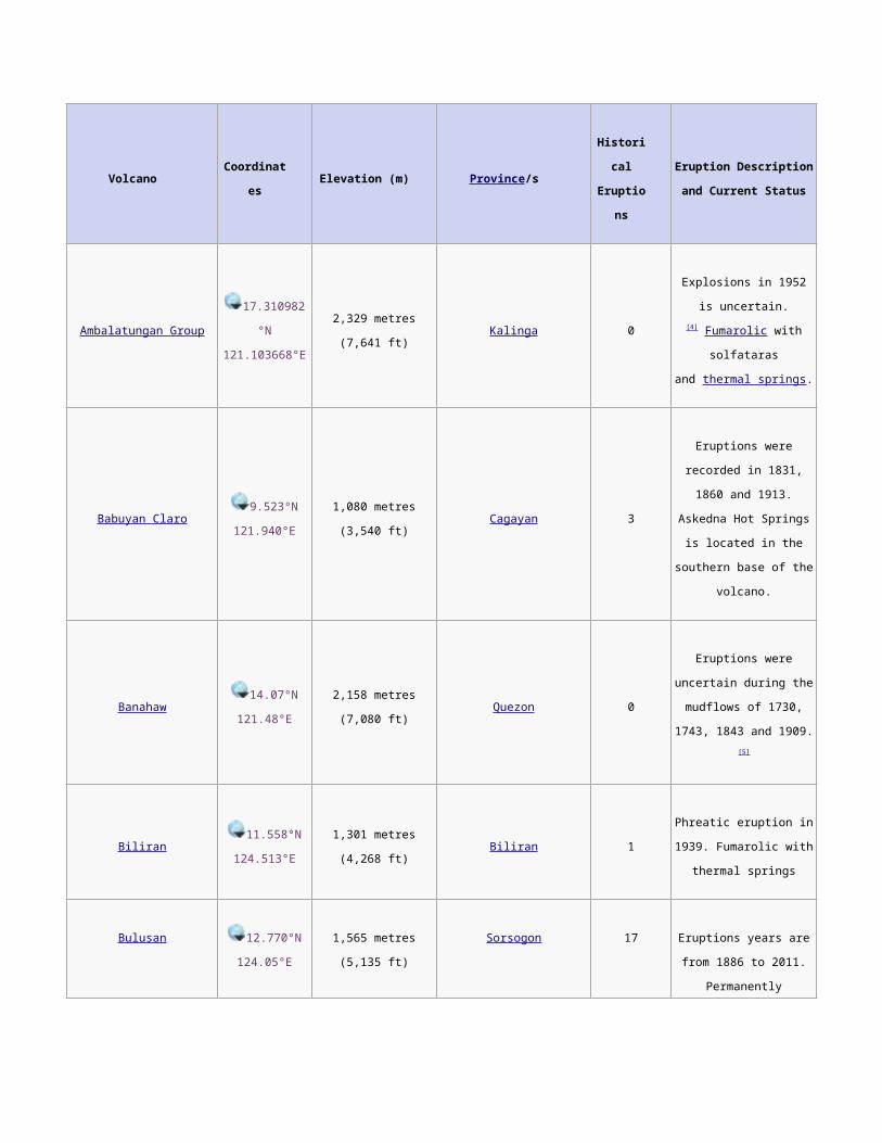
Volcano Coordinat es Elevation (m) Province /s Histori cal Eruptio ns Eruption Description and Current Status Ambalatungan Group 17.310982 °N 121.103668°E 2,329 metres (7,641 ft) Kalinga 0 Explosions in 1952 is uncertain. [4] Fumarolic with solfataras and thermal springs . Babuyan Claro 9.523°N 121.940°E 1,080 metres (3,540 ft) Cagayan 3 Eruptions were recorded in 1831, 1860 and 1913. Askedna Hot Springs is located in the southern base of the volcano. Banahaw 14.07°N 121.48°E 2,158 metres (7,080 ft) Quezon 0 Eruptions were uncertain during the mudflows of 1730, 1743, 1843 and 1909. [5] Biliran 11.558°N 124.513°E 1,301 metres (4,268 ft) Biliran 1 Phreatic eruption in 1939. Fumarolic with thermal springs Bulusan 12.770°N 124.05°E 1,565 metres (5,135 ft) Sorsogon 17 Eruptions years are from 1886 to 2011. Permanently
description
all about volcano
Transcript of Volcano
Volcano Coordinates Elevation (m) Province/sHistorical
Eruptions
Eruption Description and
Current Status
Ambalatungan Group17.310982°N
121.103668°E2,329 metres (7,641 ft) Kalinga 0
Explosions in 1952 is
uncertain.[4] Fumarolic with
solfataras and thermal
springs.
Babuyan Claro9.523°N
121.940°E1,080 metres (3,540 ft) Cagayan 3
Eruptions were recorded in
1831, 1860 and 1913.
Askedna Hot Springs is
located in the southern
base of the volcano.
Banahaw14.07°N
121.48°E2,158 metres (7,080 ft) Quezon 0
Eruptions were uncertain
during the mudflows of
1730, 1743, 1843 and
1909.[5]
Biliran11.558°N
124.513°E1,301 metres (4,268 ft) Biliran 1
Phreatic eruption in 1939.
Fumarolic with thermal
springs
Bulusan12.770°N
124.05°E1,565 metres (5,135 ft) Sorsogon 17
Eruptions years are from
1886 to 2011. Permanently
monitored
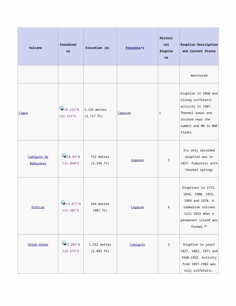
Cagua18.222°N
122.123°E1,133 metres (3,717 ft) Cagayan 1
Eruption in 1860 and
strong solfataric activity in
1907. Thermal areas are
located near the summit
and NW to NNE flanks.
Volcano Coordinates Elevation (m) Province/sHistorical
Eruptions
Eruption Description and
Current Status
Camiguin de Babuyanes18.83°N
121.860°E712 metres (2,336 ft) Cagayan 1
Its only recorded eruption
was in 1857. Fumarolic
with thermal springs
Didicas19.077°N
122.202°E244 metres (801 ft) Cagayan 6
Eruptions in 1773, 1856,
1900, 1952, 1969 and
1978. A submarine
volcano till 1952 when a
permanent island was
formed.[6]
Hibok-Hibok9.203°N
124.673°E1,552 metres (5,092 ft) Camiguin 5
Eruption in years 1827,
1862, 1871 and 1948–
1952. Activity from 1897-
1902 was only solfataric.
Permanently monitored.
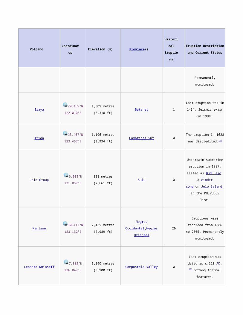
Iraya20.469°N
122.010°E1,009 metres (3,310 ft) Batanes 1
Last eruption was in 1454.
Seismic swarm in 1998.
Iriga13.457°N
123.457°E1,196 metres (3,924 ft) Camarines Sur 0
The eruption in 1628 was
discredited.[7]
Jolo Group6.013°N
121.057°E811 metres (2,661 ft) Sulu 0
Uncertain submarine
eruption in 1897. Listed
as Bud Dajo, a cinder
cone on Jolo Island, in the
PHIVOLCS list.
Volcano Coordinates Elevation (m) Province/sHistorical
Eruptions
Eruption Description and
Current Status
Kanlaon10.412°N
123.132°E2,435 metres (7,989 ft)
Negros Occidental,Negros
Oriental26
Eruptions were recorded
from 1886 to 2006.
Permanently monitored.
Leonard Kniaseff7.382°N
126.047°E1,190 metres (3,900 ft) Compostela Valley 0
Last eruption was dated as
c.120 AD.[8] Strong thermal
features.
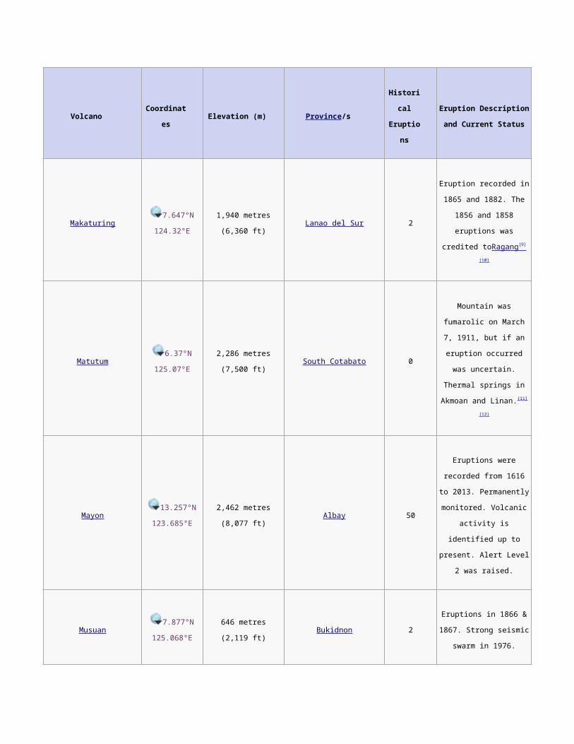
Makaturing7.647°N
124.32°E1,940 metres (6,360 ft) Lanao del Sur 2
Eruption recorded in 1865
and 1882. The 1856 and
1858 eruptions was
credited toRagang [9] [10]
Matutum6.37°N
125.07°E2,286 metres (7,500 ft) South Cotabato 0
Mountain was fumarolic on
March 7, 1911, but if an
eruption occurred was
uncertain. Thermal springs
in Akmoan and Linan.[11][12]
Mayon13.257°N
123.685°E2,462 metres (8,077 ft) Albay 50
Eruptions were recorded
from 1616 to 2013.
Permanently monitored.
Volcanic activity is
identified up to present.
Alert Level 2 was raised.
Musuan7.877°N
125.068°E646 metres (2,119 ft) Bukidnon 2
Eruptions in 1866 & 1867.
Strong seismic swarm in
1976.
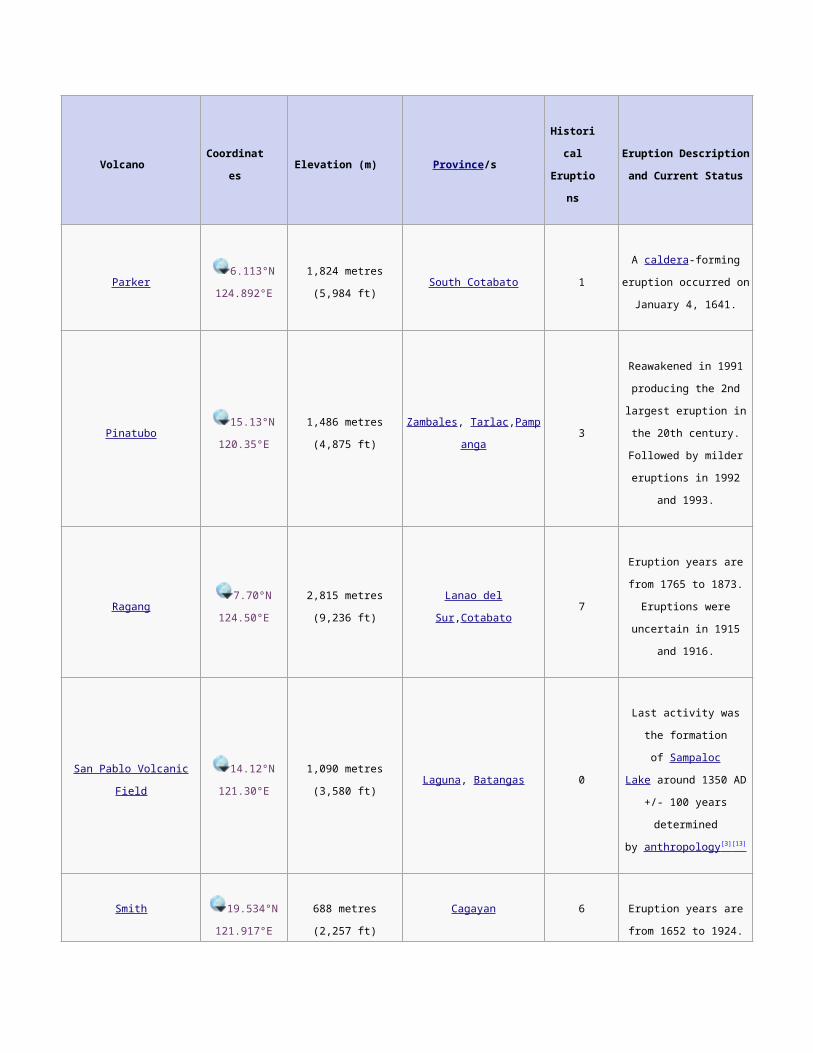
Volcano Coordinates Elevation (m) Province/sHistorical
Eruptions
Eruption Description and
Current Status
Parker6.113°N
124.892°E1,824 metres (5,984 ft) South Cotabato 1
A caldera-forming eruption
occurred on January 4,
1641.
Pinatubo15.13°N
120.35°E1,486 metres (4,875 ft)
Zambales, Tarla
c,Pampanga3
Reawakened in 1991
producing the 2nd largest
eruption in the 20th
century. Followed by
milder eruptions in 1992
and 1993.
Ragang7.70°N
124.50°E2,815 metres (9,236 ft) Lanao del Sur,Cotabato 7
Eruption years are from
1765 to 1873. Eruptions
were uncertain in 1915
and 1916.
San Pablo Volcanic Field14.12°N
121.30°E1,090 metres (3,580 ft) Laguna, Batangas 0
Last activity was the
formation of Sampaloc
Lake around 1350 AD +/-
100 years determined
by anthropology [3] [13]
Smith19.534°N
121.917°E688 metres (2,257 ft) Cagayan 6
Eruption years are from
1652 to 1924. Combined
with Babuyan Claro on the
GVP list.
Taal 14.002°N
120.993°E
400 metres (1,300 ft) Batangas 33 Eruption years is from
1572 to 1977. Showing
Volcano Coordinates Elevation (m) Province/sHistorical
Eruptions
Eruption Description and
Current Status
signs of unrest since 1991
and permanently
monitored.
Unnamed volcano (Ibugos)20.33°N
121.75°E−24 metres (−79 ft) Batanes 3
Submarine eruptions in
1773, 1850 and 1854.
Active volcanoes in the Philippines