Visual change detection study of some of the urban areas of
11
INTERNATIONAL JOURNAL OF GEOMATICS AND GEOSCIENCES Volume 3, No 3, 2013 © Copyright by the authors - Licensee IPA- Under Creative Commons license 3.0 Research article ISSN 0976 – 4380 Submitted on December 2012 published on March 2013 500 Visual change detection study of some of the urban areas of Assam, India using Remote Sensing Shukla Acharjee 1 , Uttam Goswami2, Ranjan Saikia 3 1- Centre for Studies in Geography, Dibrugarh University, Dibrugarh-786004, Assam, India 2- Department of Applied Geology, Dibrugarh University, Dibrugarh-786004, Assam, India 3- Department of Geography, Cotton College, Guwahati-781001, Assam, India [email protected] ABSTRACT Remote Sensing is an efficient tool for change detection of land cover/forest cover/ urban mapping incorporating satellite imagery. It not only provides us with the extents but also indicates some cultural, political and ecological impacts due to which the changes have occurred or land cover is tempered. The images indicate such changes in the urban areas of Assam. From these images the severity and extent of deforestation is an eye-opener. In Assam along the Brahmaputra and the riverine tracts of its tributaries, several cities are selected where the extent and severity of deforestation is high. These cities belong to the districts of Tinsukia, Dibrugarh, Sivasagar, Jorhat, Golaghat, Nagaon, and Kamrup all along the river. The urban sprawl area is studied taking 1974 and 2009 Landsat imageries using ArcGIS online explorer. It has been found that vast changes occurred due to migration of the people to cities in search of jobs and cultural advantages, and this has resulted in the formation of huge urban areas and surrounding periurban environs. But its effects are impacting the quality of life in every region of Assam, in the large cities and small towns. The present trend is to rapidly develop farms, agricultural land and forests into housing developments or strip malls. And the rate of development is accelerating. As a result, people suffer from increased traffic congestion, longer commutes, increased dependence on fossil fuels, crowded schools, worsened air and water pollution, threatened surface and ground water supplies, lost open space and wetlands, increased flooding, destroyed wildlife habitat, higher taxes, and dying city centres. Moreover, sprawl is creating a hidden debt of unfunded infrastructure and services, social dysfunction, urban decay and environmental degradation. Key Words: Remote sensing, change detection, deforestation, urban areas, imagery. 1. Introduction Remote Sensing is an efficient tool for change detection of land cover/forest cover/ urban mapping incorporating satellite imagery. It not only provides us with the extents but also indicates some cultural, political and ecological impacts due to which the changes have occurred or land cover is tempered. The images indicate such changes in the urban areas of Assam. From these images the severity and extent of deforestation is an eye-opener. In Assam along the Brahmaputra riverine tract, several cities are selected where the deforestation extent and severity is high. These cities/towns fall in the districts of Tinsukia, Dibrugarh, Sivasagar, Jorhat, Golaghat, Nagaon and Kamrup all along the river Brahmaputra and its tributaries. The locations of these districts under study are shown in figure 1.
Transcript of Visual change detection study of some of the urban areas of
INTERNATIONAL JOURNAL OF GEOMATICS AND GEOSCIENCES
Volume 3, No 3, 2013
© Copyright by the authors - Licensee IPA- Under Creative Commons license 3.0
Research article ISSN 0976 – 4380
Submitted on December 2012 published on March 2013 500
Visual change detection study of some of the urban areas of Assam, India
using Remote Sensing Shukla Acharjee
1, Uttam Goswami2, Ranjan Saikia
3
1- Centre for Studies in Geography, Dibrugarh University, Dibrugarh-786004, Assam, India
2- Department of Applied Geology, Dibrugarh University, Dibrugarh-786004, Assam, India
3- Department of Geography, Cotton College, Guwahati-781001, Assam, India
ABSTRACT
Remote Sensing is an efficient tool for change detection of land cover/forest cover/ urban
mapping incorporating satellite imagery. It not only provides us with the extents but also
indicates some cultural, political and ecological impacts due to which the changes have
occurred or land cover is tempered. The images indicate such changes in the urban areas of
Assam. From these images the severity and extent of deforestation is an eye-opener. In
Assam along the Brahmaputra and the riverine tracts of its tributaries, several cities are
selected where the extent and severity of deforestation is high. These cities belong to the
districts of Tinsukia, Dibrugarh, Sivasagar, Jorhat, Golaghat, Nagaon, and Kamrup all along
the river. The urban sprawl area is studied taking 1974 and 2009 Landsat imageries using
ArcGIS online explorer. It has been found that vast changes occurred due to migration of the
people to cities in search of jobs and cultural advantages, and this has resulted in the
formation of huge urban areas and surrounding periurban environs. But its effects are
impacting the quality of life in every region of Assam, in the large cities and small towns.
The present trend is to rapidly develop farms, agricultural land and forests into housing
developments or strip malls. And the rate of development is accelerating. As a result, people
suffer from increased traffic congestion, longer commutes, increased dependence on fossil
fuels, crowded schools, worsened air and water pollution, threatened surface and ground
water supplies, lost open space and wetlands, increased flooding, destroyed wildlife habitat,
higher taxes, and dying city centres. Moreover, sprawl is creating a hidden debt of unfunded
infrastructure and services, social dysfunction, urban decay and environmental degradation.
Key Words: Remote sensing, change detection, deforestation, urban areas, imagery.
1. Introduction
Remote Sensing is an efficient tool for change detection of land cover/forest cover/ urban
mapping incorporating satellite imagery. It not only provides us with the extents but also
indicates some cultural, political and ecological impacts due to which the changes have
occurred or land cover is tempered. The images indicate such changes in the urban areas of
Assam. From these images the severity and extent of deforestation is an eye-opener. In
Assam along the Brahmaputra riverine tract, several cities are selected where the
deforestation extent and severity is high. These cities/towns fall in the districts of Tinsukia,
Dibrugarh, Sivasagar, Jorhat, Golaghat, Nagaon and Kamrup all along the river Brahmaputra
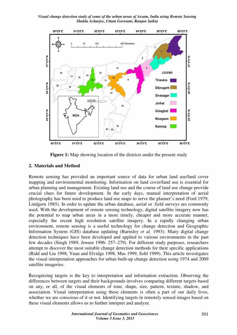
and its tributaries. The locations of these districts under study are shown in figure 1.
Visual change detection study of some of the urban areas of Assam, India using Remote Sensing
Shukla Acharjee, Uttam Goswami, Ranjan Saikia
International Journal of Geomatics and Geosciences
Volume 3 Issue 3, 2013 501
Figure 1: Map showing location of the districts under the present study
2. Materials and Method
Remote sensing has provided an important source of data for urban land use/land cover
mapping and environmental monitoring. Information on land cover/land use is essential for
urban planning and management. Existing land use and the course of land use change provide
crucial clues for future development. In the early days, manual interpretation of aerial
photography has been used to produce land use maps to serve the planner’s need (Ford 1979,
Lindgern 1985). In order to update the urban database, aerial or .field surveys are commonly
used. With the development of remote sensing technology, digital satellite imagery now has
the potential to map urban areas in a more timely, cheaper and more accurate manner,
especially the recent high resolution satellite imagery. In a rapidly changing urban
environment, remote sensing is a useful technology for change detection and Geographic
Information System (GIS) database updating (Barnsley et al. 1993). Many digital change
detection techniques have been developed and applied to various environments in the past
few decades (Singh 1989, Jensen 1996: 257–279). For different study purposes, researchers
attempt to discover the most suitable change detection methods for their specific applications
(Ridd and Liu 1998, Yuan and Elvidge 1998, Mas 1999, Sohl 1999). This article investigates
the visual interpretation approaches for urban built-up change detection using 1974 and 2009
satellite imageries.
Recognizing targets is the key to interpretation and information extraction. Observing the
differences between targets and their backgrounds involves comparing different targets based
on any, or all, of the visual elements of tone, shape, size, pattern, texture, shadow, and
association. Visual interpretation using these elements is often a part of our daily lives,
whether we are conscious of it or not. Identifying targets in remotely sensed images based on
these visual elements allows us to further interpret and analyze.
Visual change detection study of some of the urban areas of Assam, India using Remote Sensing
Shukla Acharjee, Uttam Goswami, Ranjan Saikia
International Journal of Geomatics and Geosciences
Volume 3 Issue 3, 2013 502
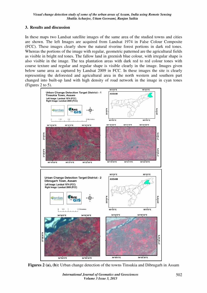
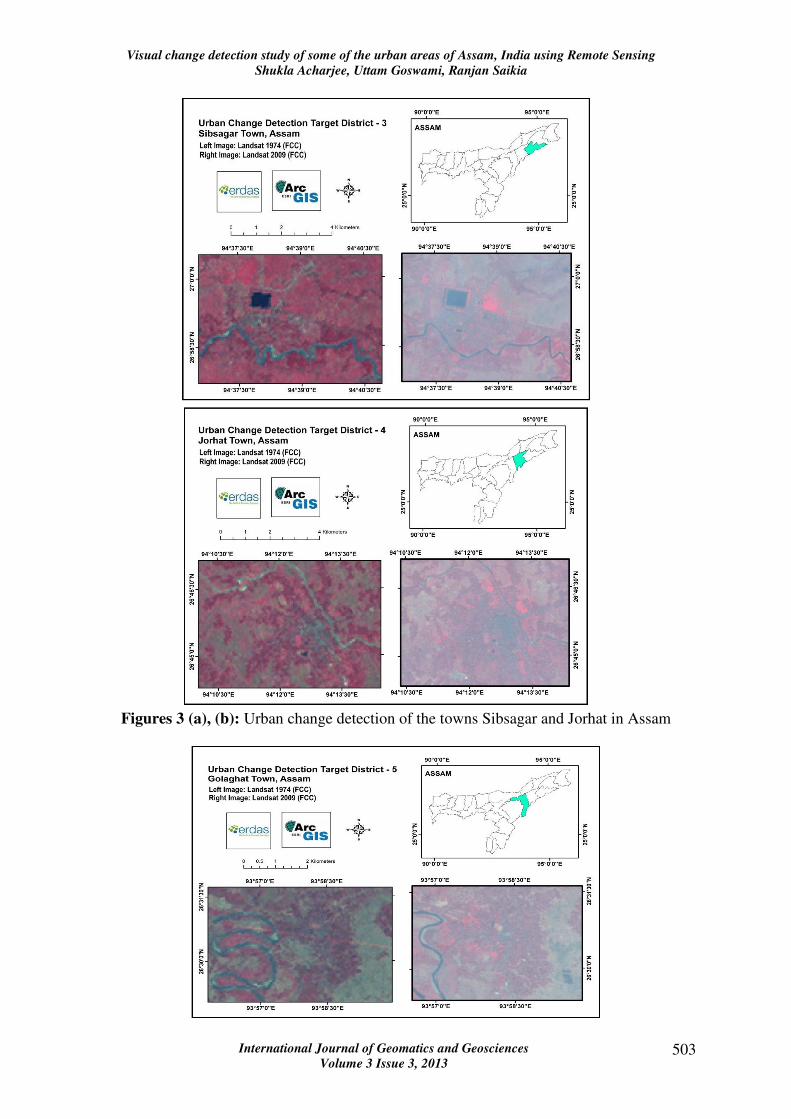
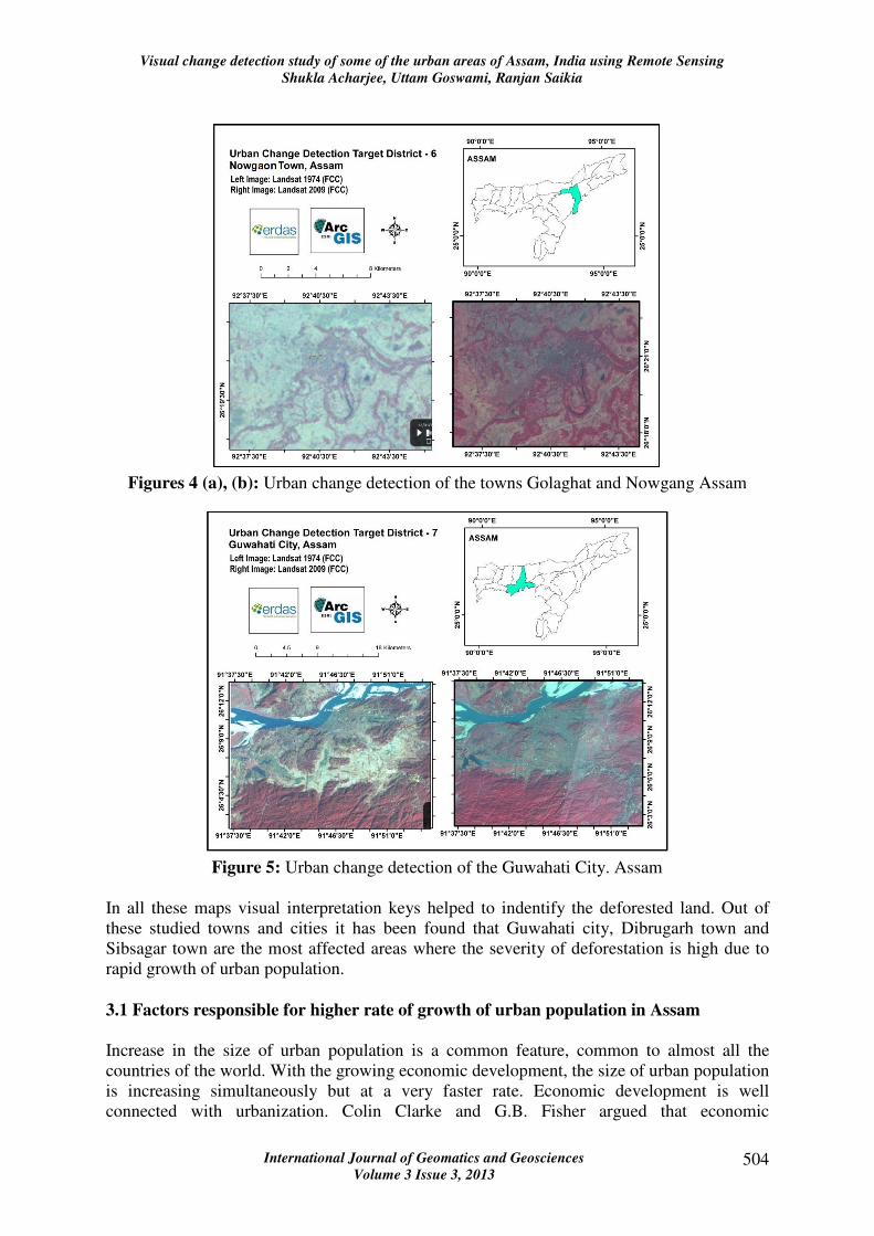
3. Results and discussion
In these maps two Landsat satellite images of the same area of the studied towns and cities
are shown. The left Images are acquired from Landsat 1974 in False Colour Composite
(FCC). These images clearly show the natural riverine forest portions in dark red tones.
Whereas the portions of the image with regular, geometric patterned are the agricultural fields
as visible in bright red tones. The fallow land in greenish blue colour, with irregular shape is
also visible in the image. The tea plantation areas with dark red to red colour tones with
course texture and regular and regular shape is visible clearly in the image. Images given
below same area as captured by Landsat 2009 in FCC. In these images the site is clearly
representing the deforested and agricultural area in the north western and southern part
changed into built-up land with high density of road network in the image in cyan tones
(Figures 2 to 5).
Figures 2 (a), (b): Urban change detection of the towns Tinsukia and Dibrugarh in Assam
Visual change detection study of some of the urban areas of Assam, India using Remote Sensing
Shukla Acharjee, Uttam Goswami, Ranjan Saikia
International Journal of Geomatics and Geosciences
Volume 3 Issue 3, 2013 503
Figures 3 (a), (b): Urban change detection of the towns Sibsagar and Jorhat in Assam
Visual change detection study of some of the urban areas of Assam, India using Remote Sensing
Shukla Acharjee, Uttam Goswami, Ranjan Saikia
International Journal of Geomatics and Geosciences
Volume 3 Issue 3, 2013 504
Figures 4 (a), (b): Urban change detection of the towns Golaghat and Nowgang Assam
Figure 5: Urban change detection of the Guwahati City. Assam
In all these maps visual interpretation keys helped to indentify the deforested land. Out of
these studied towns and cities it has been found that Guwahati city, Dibrugarh town and
Sibsagar town are the most affected areas where the severity of deforestation is high due to
rapid growth of urban population.
3.1 Factors responsible for higher rate of growth of urban population in Assam
Increase in the size of urban population is a common feature, common to almost all the
countries of the world. With the growing economic development, the size of urban population
is increasing simultaneously but at a very faster rate. Economic development is well
connected with urbanization. Colin Clarke and G.B. Fisher argued that economic
Visual change detection study of some of the urban areas of Assam, India using Remote Sensing
Shukla Acharjee, Uttam Goswami, Ranjan Saikia
International Journal of Geomatics and Geosciences
Volume 3 Issue 3, 2013 505
development is very much symptomized by the shift of population from the rural to the urban
areas. Similar is also case for Assam where the size of urban population has been estimated
that since 1951 to 1971 nearly 25 to 30 lakhs people have migrated to Assam from outside
the state. Again in the post 1971 period, another 10 to 15 lakh of people is estimated to have
entered areas where they can earn higher amount of income and can provide better
educational facilities to their children and can also enjoy better social services like medical
care, housing facilities etc.
3.2 General Factors
Causes of urbanization are many and varied. There are many factors which are responsible
for high rate of growth of urban population in Assam. One such very important factor is the
natural growth of urban population which includes migration of population from rural to
urban areas. Factors like change in administrative status of certain unit and consequent
enlargement of government expenditure and employment potentialities along with the
expansion of educational facilities etc. are highly responsible for such migration of
population from rural to urban areas. Moreover, a change in the definition of urban areas
adopted by census operations and inclusion of some fringe areas within such towns are also
responsible for such a high rate of increase in urban population.
3.3 Special Factors
There are certain special factors which are responsible for such a high rate of growth of urban
population in Assam. The following are some of those special factors:
3.3.1 Growth of urban area: With the passage of time, the sizes of urban areas have been
growing steadily. The total number of towns in Assam has increased from 23 in 1951 to 53 in
1961, 73 in 1971, 78 in 1981 and 94 in 1991. This shows that as the sizes of urban areas are
expanding with the increase in the number of towns, the increase in the size of urban
population is obvious.
3.3.2 Migration of population from rural areas of the State: In Assam, there is huge shift
of population resulting from migration of population from rural to urban areas in search of
better employment opportunities and better social services related to education, health etc.
Such type of migration became acute in Assam since eighties of the last century.
3.3.3 Migration from other States: With the growing industrialization and expansion of
trade and commerce in the urban areas of Assam, a huge number of population has migrated
to the urban areas of the State from other states of India. Such migration is essential in the
initial stage of development of a region as it provides capital, efficient manpower etc.
3.3.4 Immigration: Large scale immigration of population from the neighbouring countries
like Bangladesh, erstwhile East Pakistan, Nepal etc. causes a high rate of growth of urban
population in Assam. Such immigration was very high during 1961-71 and even in recent
times such immigration is continuing.
3.3.5 Natural factors: Natural factors leading to a high rate of growth of population is also
common in respect of growth of urban population. With the growth of medical facilities in
the urban areas, death rate declines significantly but the birth rate in the urban areas did not
fall commensurately. This has led to high natural growth rate of urban population in Assam.
Visual change detection study of some of the urban areas of Assam, India using Remote Sensing
Shukla Acharjee, Uttam Goswami, Ranjan Saikia
International Journal of Geomatics and Geosciences
Volume 3 Issue 3, 2013 506
3.3.6 Neglect of the village economy: In Assam, the village economies are largely neglected
in spite of its huge potential and necessities. Although Assam is an agricultural state but the
development of the agricultural sector in the state has been mostly neglected. Agricultural
operation in the state has not yet been modernized. Basic facilities required for the
modernization of agriculture, viz., irrigation, supply of basic inputs like HYV seeds,
fertilizers, pesticides etc. have not yet been provided adequately in the rural areas of the state.
Due to lack of agricultural research and absence of intensive cultivation, the agricultural
sectors have largely remained under-developed. Moreover, in the absence of the availability
of alternative employment opportunities due to lack of industrialization and more particularly
due to lack of adequate development of small, cottage and village industries in the rural areas
of the state, growing number of rural people did not find sufficient avenues for gainful
employment in the rural areas itself. Thus there is continuous outflow of rural population to
the urban areas of the state in search of gainful employment.
Thus under such a situation, this high rate of growth of urban population in Assam has been
resulting in various evils such as growth of slums, increasing congestion and pollution,
problems of transportation, housing, water supply, health services, sanitation and finally to
unemployment and poverty.
3.4 Consequences of urbanization
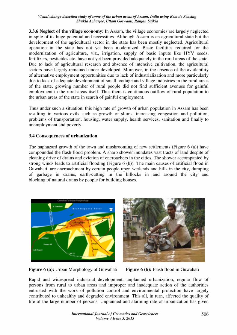
The haphazard growth of the town and mushrooming of new settlements (Figure 6 (a)) have
compounded the flash flood problem. A sharp shower inundates vast tracts of land despite of
cleaning drive of drains and eviction of encroachers in the cities. The shower accompanied by
strong winds leads to artificial flooding (Figure 6 (b)). The main causes of artificial flood in
Guwahati, are encroachment by certain people upon wetlands and hills in the city, dumping
of garbage in drains, earth-cutting in the hillocks in and around the city and
blocking of natural drains by people for building houses.
Figure 6 (a): Urban Morphology of Guwahati Figure 6 (b): Flash flood in Guwahati
Rapid and widespread industrial development, unplanned urbanization, regular flow of
persons from rural to urban areas and improper and inadequate action of the authorities
entrusted with the work of pollution control and environmental protection have largely
contributed to unhealthy and degraded environment. This all, in turn, affected the quality of
life of the large number of persons. Unplanned and alarming rate of urbanization has given
Visual change detection study of some of the urban areas of Assam, India using Remote Sensing
Shukla Acharjee, Uttam Goswami, Ranjan Saikia
International Journal of Geomatics and Geosciences
Volume 3 Issue 3, 2013 507
rise to many environment related problems, such as problem of health and hygiene, sewage,
disposal of solid waste, air, water and land pollution, slums, housing, basic amenities and
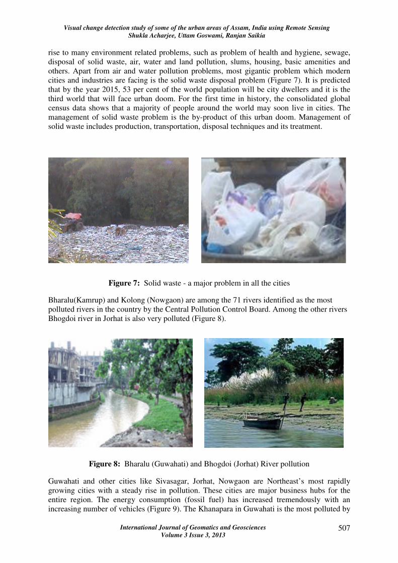
others. Apart from air and water pollution problems, most gigantic problem which modern
cities and industries are facing is the solid waste disposal problem (Figure 7). It is predicted
that by the year 2015, 53 per cent of the world population will be city dwellers and it is the
third world that will face urban doom. For the first time in history, the consolidated global
census data shows that a majority of people around the world may soon live in cities. The
management of solid waste problem is the by-product of this urban doom. Management of
solid waste includes production, transportation, disposal techniques and its treatment.
Figure 7: Solid waste - a major problem in all the cities
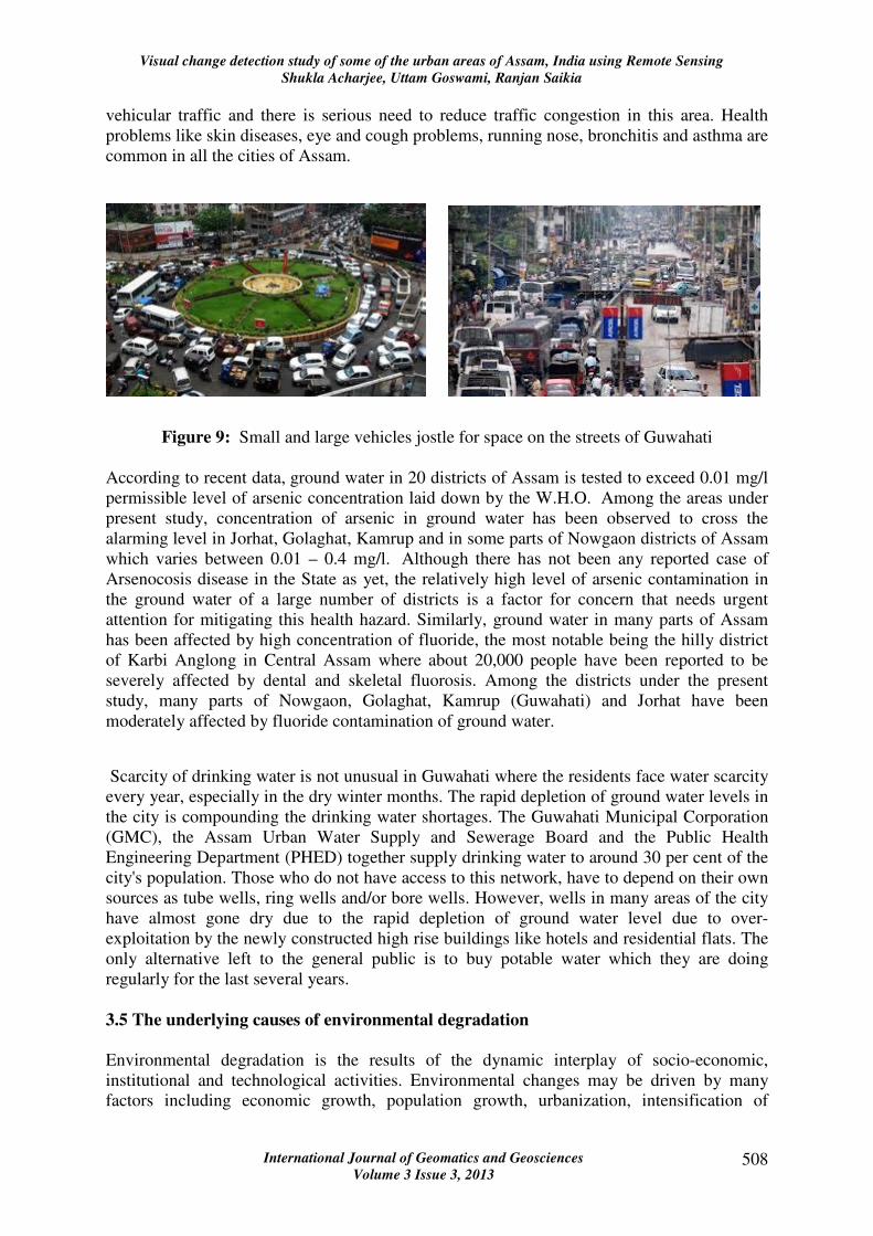
Bharalu(Kamrup) and Kolong (Nowgaon) are among the 71 rivers identified as the most
polluted rivers in the country by the Central Pollution Control Board. Among the other rivers
Bhogdoi river in Jorhat is also very polluted (Figure 8).
Figure 8: Bharalu (Guwahati) and Bhogdoi (Jorhat) River pollution
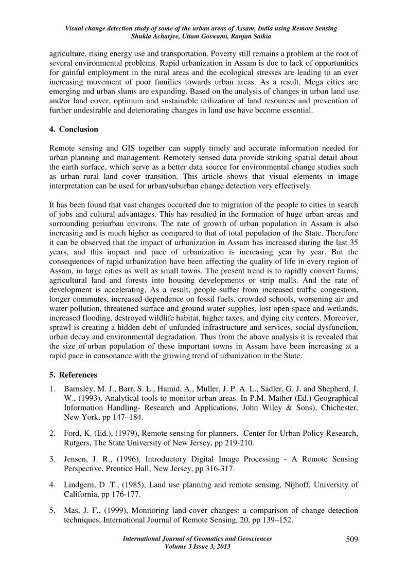
Guwahati and other cities like Sivasagar, Jorhat, Nowgaon are Northeast’s most rapidly
growing cities with a steady rise in pollution. These cities are major business hubs for the
entire region. The energy consumption (fossil fuel) has increased tremendously with an
increasing number of vehicles (Figure 9). The Khanapara in Guwahati is the most polluted by
Visual change detection study of some of the urban areas of Assam, India using Remote Sensing
Shukla Acharjee, Uttam Goswami, Ranjan Saikia
International Journal of Geomatics and Geosciences
Volume 3 Issue 3, 2013 508
vehicular traffic and there is serious need to reduce traffic congestion in this area. Health
problems like skin diseases, eye and cough problems, running nose, bronchitis and asthma are
common in all the cities of Assam.
Figure 9: Small and large vehicles jostle for space on the streets of Guwahati
According to recent data, ground water in 20 districts of Assam is tested to exceed 0.01 mg/l
permissible level of arsenic concentration laid down by the W.H.O. Among the areas under
present study, concentration of arsenic in ground water has been observed to cross the
alarming level in Jorhat, Golaghat, Kamrup and in some parts of Nowgaon districts of Assam
which varies between 0.01 – 0.4 mg/l. Although there has not been any reported case of
Arsenocosis disease in the State as yet, the relatively high level of arsenic contamination in
the ground water of a large number of districts is a factor for concern that needs urgent
attention for mitigating this health hazard. Similarly, ground water in many parts of Assam
has been affected by high concentration of fluoride, the most notable being the hilly district
of Karbi Anglong in Central Assam where about 20,000 people have been reported to be
severely affected by dental and skeletal fluorosis. Among the districts under the present
study, many parts of Nowgaon, Golaghat, Kamrup (Guwahati) and Jorhat have been
moderately affected by fluoride contamination of ground water.
Scarcity of drinking water is not unusual in Guwahati where the residents face water scarcity
every year, especially in the dry winter months. The rapid depletion of ground water levels in
the city is compounding the drinking water shortages. The Guwahati Municipal Corporation
(GMC), the Assam Urban Water Supply and Sewerage Board and the Public Health
Engineering Department (PHED) together supply drinking water to around 30 per cent of the
city's population. Those who do not have access to this network, have to depend on their own
sources as tube wells, ring wells and/or bore wells. However, wells in many areas of the city
have almost gone dry due to the rapid depletion of ground water level due to over-
exploitation by the newly constructed high rise buildings like hotels and residential flats. The
only alternative left to the general public is to buy potable water which they are doing
regularly for the last several years.
3.5 The underlying causes of environmental degradation
Environmental degradation is the results of the dynamic interplay of socio-economic,
institutional and technological activities. Environmental changes may be driven by many
factors including economic growth, population growth, urbanization, intensification of
Visual change detection study of some of the urban areas of Assam, India using Remote Sensing
Shukla Acharjee, Uttam Goswami, Ranjan Saikia
International Journal of Geomatics and Geosciences
Volume 3 Issue 3, 2013 509
agriculture, rising energy use and transportation. Poverty still remains a problem at the root of
several environmental problems. Rapid urbanization in Assam is due to lack of opportunities
for gainful employment in the rural areas and the ecological stresses are leading to an ever
increasing movement of poor families towards urban areas. As a result, Mega cities are
emerging and urban slums are expanding. Based on the analysis of changes in urban land use
and/or land cover, optimum and sustainable utilization of land resources and prevention of
further undesirable and deteriorating changes in land use have become essential.
4. Conclusion
Remote sensing and GIS together can supply timely and accurate information needed for
urban planning and management. Remotely sensed data provide striking spatial detail about
the earth surface, which serve as a better data source for environmental change studies such
as urban–rural land cover transition. This article shows that visual elements in image
interpretation can be used for urban/suburban change detection very effectively.
It has been found that vast changes occurred due to migration of the people to cities in search
of jobs and cultural advantages. This has resulted in the formation of huge urban areas and
surrounding periurban environs. The rate of growth of urban population in Assam is also
increasing and is much higher as compared to that of total population of the State. Therefore
it can be observed that the impact of urbanization in Assam has increased during the last 35
years, and this impact and pace of urbanization is increasing year by year. But the
consequences of rapid urbanization have been affecting the quality of life in every region of
Assam, in large cities as well as small towns. The present trend is to rapidly convert farms,
agricultural land and forests into housing developments or strip malls. And the rate of
development is accelerating. As a result, people suffer from increased traffic congestion,
longer commutes, increased dependence on fossil fuels, crowded schools, worsening air and
water pollution, threatened surface and ground water supplies, lost open space and wetlands,
increased flooding, destroyed wildlife habitat, higher taxes, and dying city centers. Moreover,
sprawl is creating a hidden debt of unfunded infrastructure and services, social dysfunction,
urban decay and environmental degradation. Thus from the above analysis it is revealed that
the size of urban population of these important towns in Assam have been increasing at a
rapid pace in consonance with the growing trend of urbanization in the State.
5. References
1. Barnsley, M. J., Barr, S. L., Hamid, A., Muller, J. P. A. L., Sadler, G. J. and Shepherd, J.
W., (1993), Analytical tools to monitor urban areas. In P.M. Mather (Ed.) Geographical
Information Handling- Research and Applications, John Wiley & Sons), Chichester,
New York, pp 147–184.
2. Ford, K. (Ed.), (1979), Remote sensing for planners, Center for Urban Policy Research,
Rutgers, The State University of New Jersey, pp 219-210.
3. Jensen, J. R., (1996), Introductory Digital Image Processing - A Remote Sensing
Perspective, Prentice Hall, New Jersey, pp 316-317.
4. Lindgern, D .T., (1985), Land use planning and remote sensing, Nijhoff, University of
California, pp 176-177.
5. Mas, J. F., (1999), Monitoring land-cover changes: a comparison of change detection
techniques, International Journal of Remote Sensing, 20, pp 139–152.
Visual change detection study of some of the urban areas of Assam, India using Remote Sensing
Shukla Acharjee, Uttam Goswami, Ranjan Saikia
International Journal of Geomatics and Geosciences
Volume 3 Issue 3, 2013 510
6. Ridd, M. K., and Liu, J., (1998), A comparison of four algorithms for change detection in
an urban environment, Remote Sensing of Environment, 63, pp 95-100.
7. Singh, A., (1989), Digital change detection techniques using remotely-sensed data,
International Journal of Remote Sensing, 10, pp 989-1003.
8. Sohl, T. L., (1999), Change analysis in the United Arab Emirates: an investigation of
techniques. Photogrammetric Engineering and Remote Sensing, 65, pp 475-484.
9. Yuan, D., and Elvidge, C., (1998), NALC land cover change detection pilot study:
Washington DC area experiments, Remote Sensing of Environment, 66, pp166-178.