Vision - Tweed Shire · PDF filecontents. mayor’s statement 2 introduction: about...
80
Vision Tweed City Centre P L A N Revitalising Revitalising
Transcript of Vision - Tweed Shire · PDF filecontents. mayor’s statement 2 introduction: about...

Vision
Tweed City CentreP L A N
RevitalisingRevitalising
Tweed City Centre Plan Vision ISBN 978 1 74263 000 7
NSW Department of Planning & Infrastructure 2011
Disclaimer While every reasonable effort has been made to ensure that this document is correct at the time of printing, the State of New South Wales, its agents and employees, disclaim any and all liability to any person in respect of anything or the consequences of anything done or omitted to be done in reliance upon the whole or any part of this document.
Front Cover Photograph by Airview Aerial Photography
Coloured Drawings by Tim Throsby

ContentsMAYOR’S STATEMENT 2
INTRODUCTION: ABOUT REGIONAL CITIES 5
1. ABOUT THE TWEED CITY CENTRE PLAN 9
2. THE VISION FOR THE TWEED CITY CENTRE 13
3. REGIONAL CONTEXT 21
4. HISTORIC CONTEXT 25
5. DEMOGRAPHIC AND HOUSING CONTEXT 29
6. ECONOMIC DEVELOPMENT 37
7. TRANSPORT AND INFRASTRUCTURE 41
8. CLIMATE CHANGE 47
9. ENVIRONMENT AND PARKS 51
10. CITY CENTRE CHARACTER 61
11. FUTURE ACTIONS 69
12. REFERENCES 74
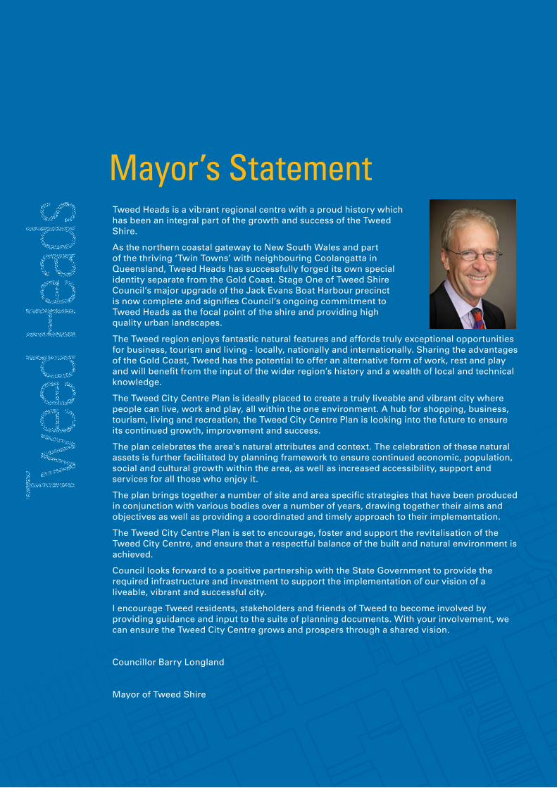
Mayor’s StatementTweed Heads is a vibrant regional centre with a proud history which has been an integral part of the growth and success of the Tweed Shire.
As the northern coastal gateway to New South Wales and part of the thriving ‘Twin Towns’ with neighbouring Coolangatta in Queensland, Tweed Heads has successfully forged its own special identity separate from the Gold Coast. Stage One of Tweed Shire Council’s major upgrade of the Jack Evans Boat Harbour precinct is now complete and signifies Council’s ongoing commitment to Tweed Heads as the focal point of the shire and providing high quality urban landscapes.
The Tweed region enjoys fantastic natural features and affords truly exceptional opportunities for business, tourism and living - locally, nationally and internationally. Sharing the advantages of the Gold Coast, Tweed has the potential to offer an alternative form of work, rest and play and will benefit from the input of the wider region’s history and a wealth of local and technical knowledge.
The Tweed City Centre Plan is ideally placed to create a truly liveable and vibrant city where people can live, work and play, all within the one environment. A hub for shopping, business, tourism, living and recreation, the Tweed City Centre Plan is looking into the future to ensure its continued growth, improvement and success.
The plan celebrates the area’s natural attributes and context. The celebration of these natural assets is further facilitated by planning framework to ensure continued economic, population, social and cultural growth within the area, as well as increased accessibility, support and services for all those who enjoy it.
The plan brings together a number of site and area specific strategies that have been produced in conjunction with various bodies over a number of years, drawing together their aims and objectives as well as providing a coordinated and timely approach to their implementation.
The Tweed City Centre Plan is set to encourage, foster and support the revitalisation of the Tweed City Centre, and ensure that a respectful balance of the built and natural environment is achieved.
Council looks forward to a positive partnership with the State Government to provide the required infrastructure and investment to support the implementation of our vision of a liveable, vibrant and successful city.
I encourage Tweed residents, stakeholders and friends of Tweed to become involved by providing guidance and input to the suite of planning documents. With your involvement, we can ensure the Tweed City Centre grows and prospers through a shared vision.
Councillor Barry Longland
Mayor of Tweed Shire

3V I S I O N
3,000 new jobs7,000 more people25 year plan1 city centre


5V I S I O N
Introduction: About regional citiesThe NSW State Government recognises the importance of regional cities in the economic growth of the state, and the need for their proper planning and servicing.
The government’s 25 year Sydney, Far North Coast, Lower Hunter, Illawarra and Central Coast regional strategies aim to create a much greater employment, activity and recreation role for key subregional and regional urban centres. Tweed Heads in the Far North Coast Region is one of the centres and has been nominated to play a dominant role in its region.
These strategies have defined a regional city as:
“A city that is a focal point for jobs that also has a full range of business, government, retail, cultural, entertainment and recreational activities.”
REGIONAL CITIES
An underlying principle is that people should be able to access a range of jobs, health and education services, cultural, entertainment and recreational activities and shopping without travelling long distances. Most people are willing to travel about an hour a day and the regional cities concept is about concentrating services and activities to satisfy this.
REGIONAL CITY DEVELOPMENT PRINCIPLES
To realise their potential each regional city needs careful planning, supported by government investment and targeted asset management. The primacy of the centres as employment nodes, supported by high quality
and appropriately located residential development, needs to be recognised. Common development principles for the regional cities include the following:
• grow jobs in the heart of the city centre;
• encourage diverse precincts around the city centre;
• create a living city by encouraging mixed use development that complements the centre’s core employment role;
• develop a distinct role and character for the centre;
• ensure high quality design of building and public areas;
• enhance transport links to and from the centre; and
• improve the natural environment.
GROWING JOBS IN THE HEART OF THE CITY CENTRE
Regional cities contain concentrations of jobs and service activities. The highest density area for jobs needs to be in the heart of the centre, close to transport and services. Planning needs to allow for sufficient floor space to accommodate future job growth.
Community, education and government activities currently provide many of the high value, high skill job opportunities in the regional cities. The continued development of these activities, and related spin-off enterprises in the private sector, is fundamental to the future success of the regional cities as job locations.
Government land and assets will also play a strategic role in the development of regional cities. A ‘whole of government’ approach is essential to

6 V I S I O N
ensure that assets are utilised to maximise outcomes for the good of the centre as a whole. The utilisation of Council assets such as libraries, civic centres, parks and land can also be reviewed to ensure they effectively support city centre development.
ENCOURAGING DIVERSE PRECINCTS AROUND THE CITY CENTRE
Regional cities all have assets which give them their pre-eminent status in the region. Universities, hospitals, parks, light industry areas, cultural and entertainment facilities, river and waterfront assets and parklands – as well as the shopping and business precincts - all make a contribution to the life and attractiveness of these places as diverse destinations.
CREATING A LIVING CITY
While a core employment role is fundamental, opportunities for additional mixed use and residential development in and around the centre exist. Attracting new residents will bring additional retail and service activity, and street life. High quality design outcomes, public places and civic improvements should be a priority in these areas.
CELEBRATING THE SPECIAL CHARACTER OF THE CENTRE
Each of the centres has a different role in its subregion and their assets underpin different competitive strengths. Although split in half by the NSW/Queensland border, Tweed Heads and Coolangatta almost function as one city. The city of Tweed Heads, however, should develop its own distinctive identity, character and role. An understanding of the importance of topography, landscape and economic and community assets in the centre and preparing development settings as appropriate, is critical.
IMPROVING THE DESIGN OF BUILDINGS AND PUBLIC AREAS
High quality architecture and design of buildings and the public domain attracts investment and visitors. Places are simply more enjoyable where innovation in design and development is on display. Regional cities need to be a symbol for wider aspirations for much better quality urban development.
ENHANCING TRANSPORT AND ACCESS TO AND AROUND THE CENTRES
As the regional cities are to become the focus for new investment and accelerated development, access to the centres is fundamental. New and upgraded public transport links, improved private vehicular access and enhanced environments for pedestrians and cyclists must be a priority.
IMPROVING THE NATURAL ENVIRONMENT
With looming environmental and climate change, the sustainability of our cities is under increasing scrutiny. The regional cities need to be exemplars for best practice performance in terms of energy and water conservation, solar access for public spaces and in encouraging transport forms that minimise air and noise pollution.
Coastal cities need to carefully balance the issue of climate change related sea level rise and flooding potential with the economic wellbeing of the city. Strategies to manage the effects of climate change need to be integrated into long term planning.
Introduction: About regional cities

7V I S I O N
RESIDENTIAL
CULTURAL
RECREATION
COMMERCIAL CORE
RESIDENTIAL
EDUCATION
ENTERPRISE
VILLAGE
VILLAGE
MEDICAL
REGIONAL CITIES CONTAIN A RANGE OF BUSINESS, GOVERNMENT, RETAIL, CULTURAL, ENTERTAINMENT AND RECREATIONAL ACTIVITIES.
Key elements of a regional city.


9V I S I O N
The Far North Coast region has been a focus for consistent population growth in recent decades. The region offers high quality lifestyles and, for many, more affordable housing than can be found in Sydney or Southeast Queensland. The natural environment - including beaches, rivers and national parks – distinctive townships and strong sense of community underpin the region’s attractiveness.
The regional cities project is all about reinvigorating the major centres of important regions and offering new lifestyle, residential, service and job opportunities. With its waterfront location and proximity to Southeast Queensland, there is great potential to increase the appeal of Tweed Heads as a destination for shopping, tourism, employment, entertainment and cultural activities, high quality health and medical services, and as a place to live. This will require economic growth and diversification to match recent population increases.
This plan recognises the fundamental connection between future economic developments and the quality of place through the redevelopment and improvement of the City Centre. The economics of the future redevelopment of the City Centre are dependent on having the underpinnings of a strong and growing regional and city based economy. At the same time to secure this growth, the City Centre has to present itself as an attractive and vibrant location to work, to live, to operate a business and to visit.
Climate Change and the potential for increased severity and frequency of flooding is a major issue in Tweed Heads, as well as in other coastal towns. The need to manage the impact of flooding has determined the confinement of increased residential densities to higher land in Tweed North. Tweed South, on lower ground,
becomes an important commercial centre, with no increase in residential density. Any increase in residential densities in South Tweed will depend upon the findings of the Floodplain Risk Management Study, which may include raised roads or levees.
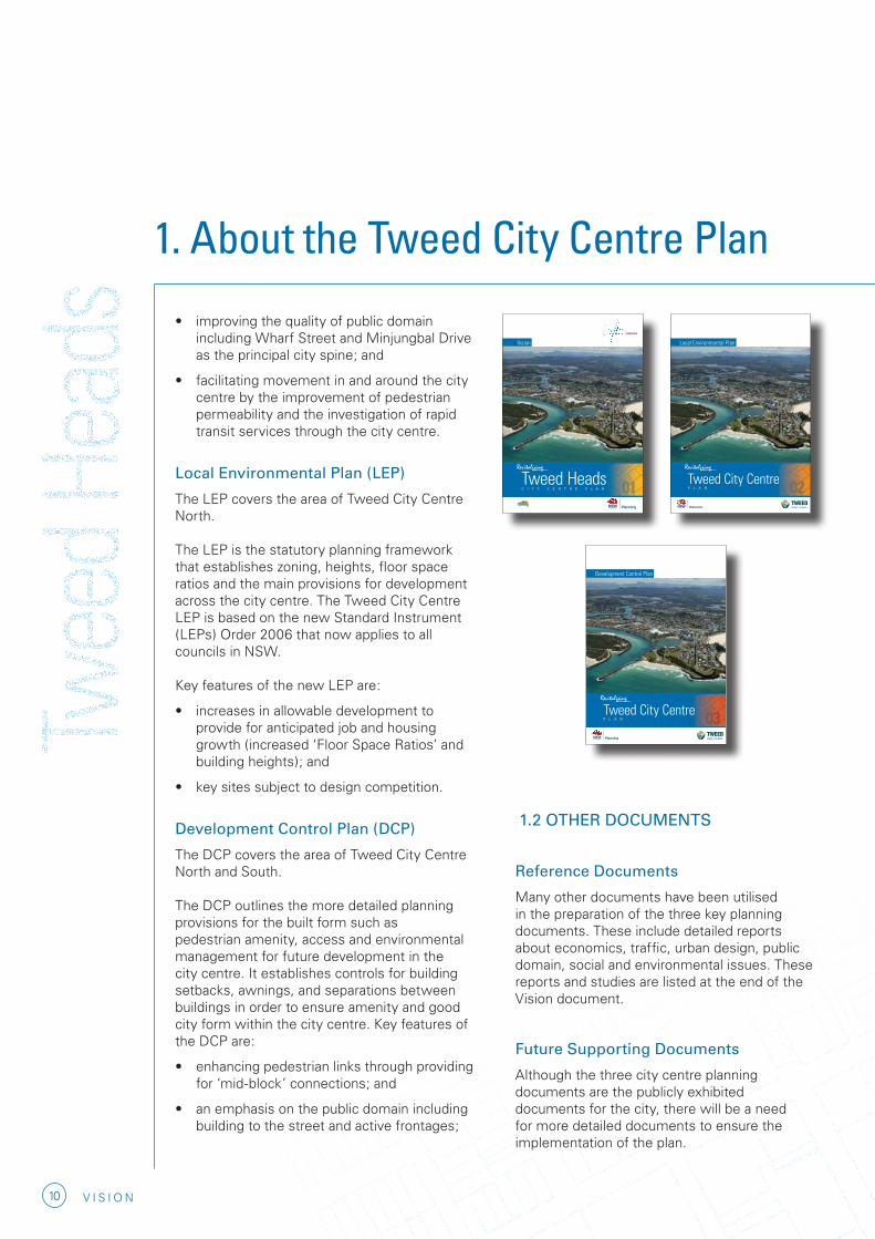
1.1 THE THREE PLANNING DOCUMENTS
The Tweed City Centre Plan is the first step in delivering this positive future for Tweed Heads, the progress of which will be monitored over time. The Plan includes the following planning documents.
The City Centre Vision
This document describes a vision for the regional city, provides information on the history and development context, and includes an action plan to facilitate the city’s growth. It sets a strategic framework for the city centre to grow into a prosperous, vibrant and attractive city.
Key actions include:
• managing climate change by undertaking a detailed flood management study which will determine future strategies for the growth of Tweed Heads.
• seeking to attract new employment and investor opportunities while harnessing local skills and talent;
• providing high quality residential development to cater for future population mix.
• encouraging the development of special areas such as Jack Evans Boat Harbour and the Civic precinct;
• managing the Tweed River foreshore to reconnect the city to its river while protecting its natural assets;
1. About the Tweed City Centre Plan
10 V I S I O N
• improving the quality of public domain including Wharf Street and Minjungbal Drive as the principal city spine; and
• facilitating movement in and around the city centre by the improvement of pedestrian permeability and the investigation of rapid transit services through the city centre.
Local Environmental Plan (LEP)
The LEP covers the area of Tweed City Centre North.
The LEP is the statutory planning framework that establishes zoning, heights, floor space ratios and the main provisions for development across the city centre. The Tweed City Centre LEP is based on the new Standard Instrument (LEPs) Order 2006 that now applies to all councils in NSW.
Key features of the new LEP are:
• increases in allowable development to provide for anticipated job and housing growth (increased ‘Floor Space Ratios’ and building heights); and
• key sites subject to design competition.
Development Control Plan (DCP)
The DCP covers the area of Tweed City Centre North and South.
The DCP outlines the more detailed planning provisions for the built form such as pedestrian amenity, access and environmental management for future development in the city centre. It establishes controls for building setbacks, awnings, and separations between buildings in order to ensure amenity and good city form within the city centre. Key features of the DCP are:
• enhancing pedestrian links through providing for ‘mid-block’ connections; and
• an emphasis on the public domain including building to the street and active frontages;
1. About the Tweed City Centre Plan
1.2 OTHER DOCUMENTS
Reference Documents
Many other documents have been utilised in the preparation of the three key planning documents. These include detailed reports about economics, traffic, urban design, public domain, social and environmental issues. These reports and studies are listed at the end of the Vision document.
Future Supporting Documents
Although the three city centre planning documents are the publicly exhibited documents for the city, there will be a need for more detailed documents to ensure the implementation of the plan.
Local Environmental Plan
RevitalisingRevitalising
Tweed City CentreP L A N
Vision
Tweed HeadsC I T Y C E N T R E P L A N
RevitalisingRevitalising
Development Control Plan
RevitalisingRevitalising
Tweed City CentreP L A N

11V I S I O N
TWEED HEADS CITY CENTRE AREA
Likely documents to accompany the plan include:
• Tweed Valley Floodplain Risk Management Study - this document is currently being updated to reflect the likely effects of climate change on sea level rise and flood potential.
• Public Domain Technical Manual – this describes the detail of the public domain elements such as; paving, lighting, tree planting, signage and street furniture.
• Project Plans – as key projects gain priority, specific project plans will be prepared, designed and documented in detail.
• Review of City Centre Plans – all planning documents need to be reviewed over time to accommodate changing circumstances or standards. The planning system in New South Wales builds in a process for modifying planning instruments and for regular reviews.
1.3 DEFINITION OF THE TWEED CITY CENTRE
The Tweed City Centre is more than the core shopping and business centre.
The LEP covers an area stretching north and west to the Queensland border, and bounded on the east and south by the Tweed River. The DCP also includes South Tweed Heads to the Tweed Heads Bypass/Minjungbal Drive.
From a strategic context the plan has also considered other key economic assets in the broader area including new industrial and residential development lands in the Tweed Shire, as well as planning initiatives for Coolangatta.
0 500 1000 1500 2000 2500m
BAY ST
BOUNDARY ST
RECR
EATI
ON S
T
CHAR
LES
ST
BOYD
ST
FRANCES ST
WHA
RF S
T
BERY
L ST
PEAR
L ST
END
ST
FLORENCE ST
BRETT ST
TUPIA AVTERRANORA TCE
SOLANDER ST
ADEL
AIDE
ST
KEITH COMPTON DR
STATE BORDER
MINJ
UNGB
AL D
R
MINJ
UNGB
AL D
R
SULL
IVAN
ST
LLOYD ST
OXLE
Y ST
WILLIAM ST
KIRKWOOD RD
TWEED HEADS BYPASS
SOORLEY ST
MACHINERY DR
TIER
NEYS
RD
GREENWAY DR
DCP Area
LAND TO WHICH THIS PLAN APPLIES
Tweed Heads City CentreLEP Area
Tweed Heads City CentreDCP Area


13V I S I O N
2. The vision for the Tweed city centre
GROWING THE CITY CENTRE
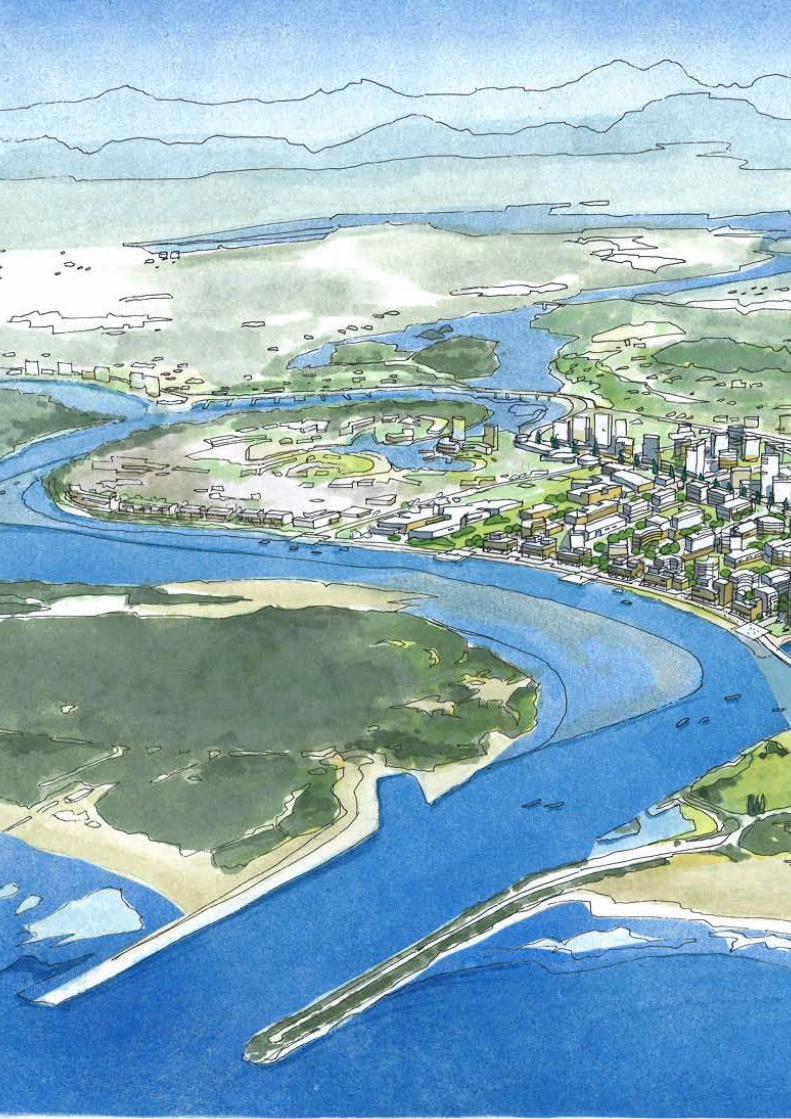
As the regional city for the Far North Coast, directly adjacent to Southeast Queensland and the Gold Coast, Tweed Heads will be a vibrant centre for jobs, key regional services, cultural activity, entertainment and tourism. Jobs will focus on high growth industries that build the city’s strengths in business services, health, education, retail, tourism and cultural activities. The city centre plan accommodates 3,000 new jobs and 7,000 new residents.
The form of the city will reflect Tweed Heads’ unique setting by increasing residential densities and concentrating higher built form towards the ridge along the Queensland border, adjacent to Coolangatta.
14 V I S I O N
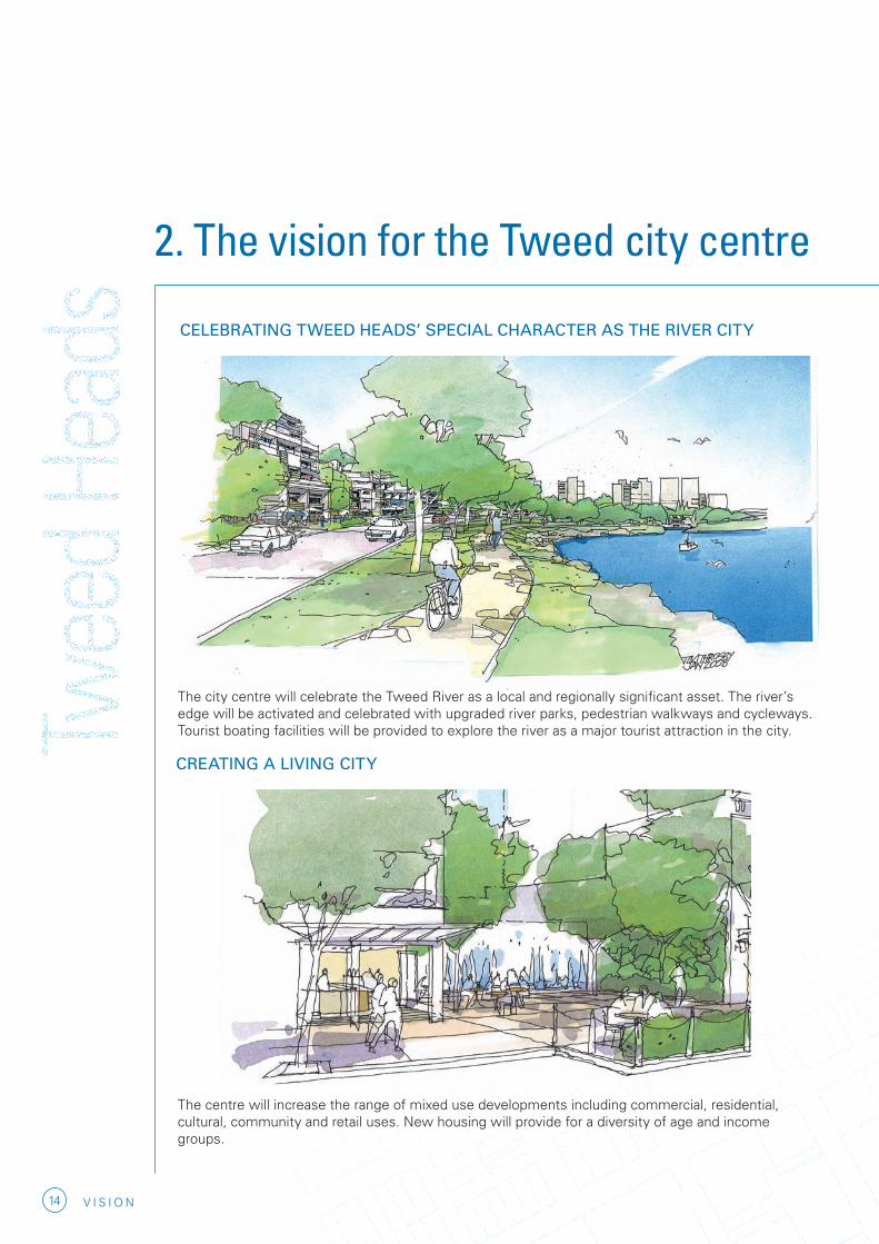
CELEBRATING TWEED HEADS’ SPECIAL CHARACTER AS THE RIVER CITY
2. The vision for the Tweed city centre
The city centre will celebrate the Tweed River as a local and regionally significant asset. The river’s edge will be activated and celebrated with upgraded river parks, pedestrian walkways and cycleways. Tourist boating facilities will be provided to explore the river as a major tourist attraction in the city.
CREATING A LIVING CITY
The centre will increase the range of mixed use developments including commercial, residential, cultural, community and retail uses. New housing will provide for a diversity of age and income groups.
15V I S I O N
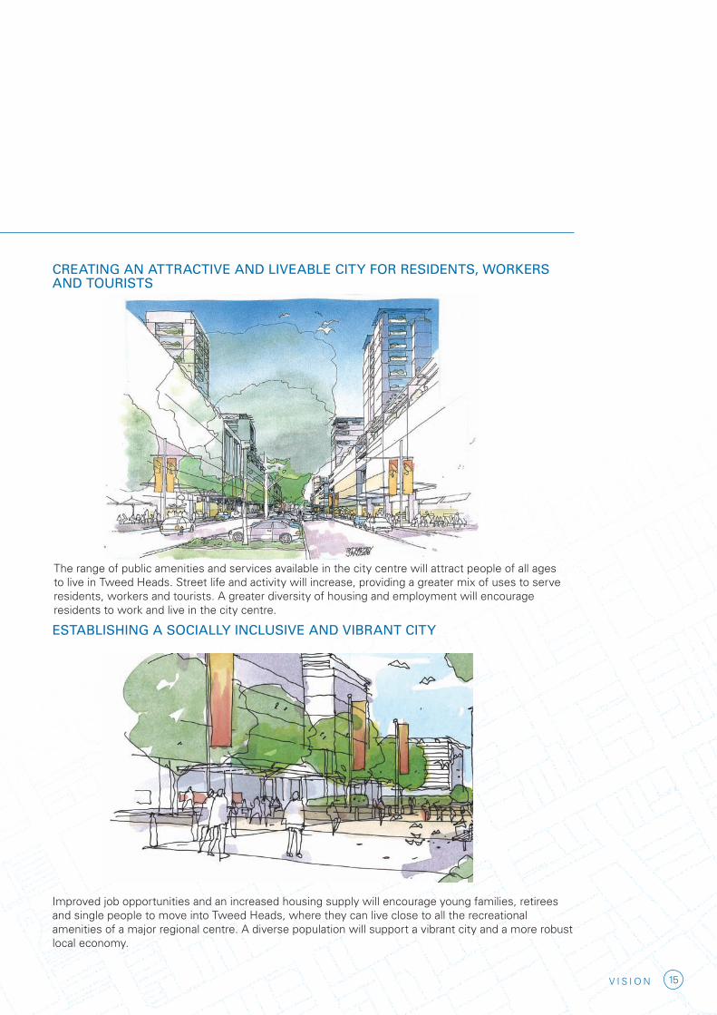
The range of public amenities and services available in the city centre will attract people of all ages to live in Tweed Heads. Street life and activity will increase, providing a greater mix of uses to serve residents, workers and tourists. A greater diversity of housing and employment will encourage residents to work and live in the city centre.
ESTABLISHING A SOCIALLY INCLUSIVE AND VIBRANT CITY
Improved job opportunities and an increased housing supply will encourage young families, retirees and single people to move into Tweed Heads, where they can live close to all the recreational amenities of a major regional centre. A diverse population will support a vibrant city and a more robust local economy.
CREATING AN ATTRACTIVE AND LIVEABLE CITY FOR RESIDENTS, WORKERS AND TOURISTS
16 V I S I O N
2. The vision for the Tweed city centre
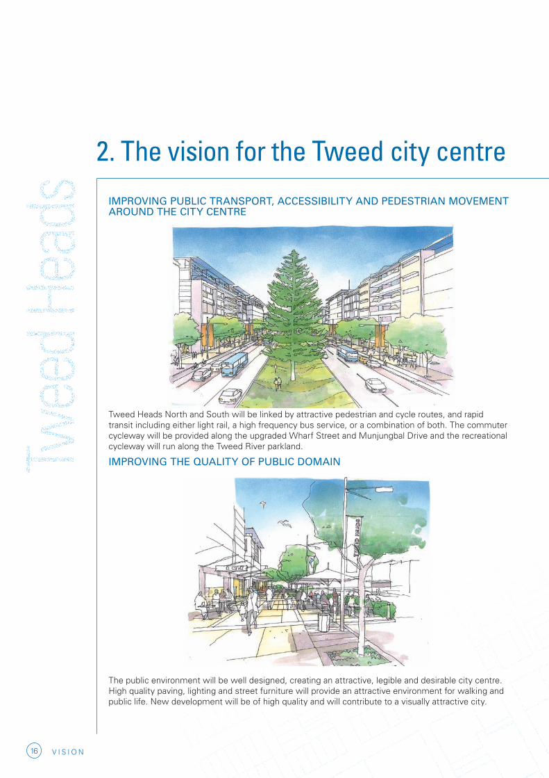
IMPROVING PUBLIC TRANSPORT, ACCESSIBILITY AND PEDESTRIAN MOVEMENT AROUND THE CITY CENTRE
Tweed Heads North and South will be linked by attractive pedestrian and cycle routes, and rapid transit including either light rail, a high frequency bus service, or a combination of both. The commuter cycleway will be provided along the upgraded Wharf Street and Munjungbal Drive and the recreational cycleway will run along the Tweed River parkland.
IMPROVING THE QUALITY OF PUBLIC DOMAIN
The public environment will be well designed, creating an attractive, legible and desirable city centre. High quality paving, lighting and street furniture will provide an attractive environment for walking and public life. New development will be of high quality and will contribute to a visually attractive city.

17V I S I O N
ENHANCING AND REVITALISING THE JACK EVANS BOAT HARBOUR AS THE FOCUS OF RECREATION AND TOURISM
Jack Evans Boat Harbour will become the key public space for the city residents, workers and tourists in Tweed Heads, a destination for recreation, leisure and entertainment. The harbour will feature major park, city beach, public plazas, boating activities, cultural uses and supporting restaurants and cafes.
ACHIEVING GREATER SUSTAINABILITY AND ENVIRONMENTAL QUALITY
Ecological sustainability will continue to be a requirement for all development. Buildings and public spaces will embrace water and energy efficiency strategies and long-life principles. All development will be subject to environmental, social and economic sustainability tests in order to preserve Tweed’s unique environmental character. The built environment and public spaces will minimise the consumption of energy and water and promote social interaction and activity.

18 V I S I O N
2. The vision for the Tweed city centre
DEVELOPING A DISTINCTIVE CITY FORM
Higher development will be concentrated on higher land to the west of Wharf Street, where it will reinforce the NSW-Queensland border. Building heights will decrease toward the river foreshore, reflecting the natural topography from the harbour to Razorback ridge
PLANNING FOR THE IMPACT OF CLIMATE CHANGE
By concentrating increased residential densities on higher land in Tweed North, the city centre can accommodate increased demand for coastal living.

19V I S I O N

town and village growth boundaryIncludes all land zoned and developed for urban purposes and future urban land release areas. Land within this boundary is for housing, business, infrastructure, community facilities, urban open space and environmental uses to meet the future regional population.
Not all land identified can be developed for urban uses. All sites will be subject to more detailed investigations to determine capability and future yield.
eXiSting urban area
eXiSting rural reSidential area
propoSed future urban releaSeLocations identified for future greenfields land release. These areas will be developed to function as new communities with service provision to match the future population of the area.
employment landS
Provides for various employment related actvities such as factories, warehouses, manufacturing and transport logistics. Identifies additional future lands to meet regional employment needs.
coaStal areaRecognises the significance of the Region’s coastal area in terms of environmental values, regional lifestyle and economic impacts associated with tourism and urban development. Limits future land release to land identified within the Town and Village Growth Boundaries.
marine park
world heritage area
State foreSt
national park, nature reServeS and conServation areaS
environmental aSSetS and rural landIdentifies areas with environmental, landscape, natural resource and agricultural production values. This area will be protected from further urban settlement with existing land use rights maintained.
rail line
60,400 more people51,000 new homes32,500 new jobs25 year plan 3 major regional centres2 major towns
major regional centre
tweed headSThe revitalisation of Tweed Heads CBD will become the focus for the Tweed urban area enabling it to provide a high level of services, employment and housing to complement those provided in the adjoining South East Queensland Region. Tweed Heads will also continue to develop as a major regional centre for tourism and the provision of retail services and community facilities.
liSmoreThe majority of the growth will occur in and around Lismore. Lismore will continue as a regional hub for creative industry and cultural activities, education, health, employment and retail.
developing major regional centre
ballinaAs a major regional centre it will be supported by new land releases in Lennox Head and Cumbalum. Employment, retail and tourism are important functions of the centre.
major town townMajor towns and towns provide a level of services and employment to support the surrounding catchments of villages and rural settlement.
village - coaStal
village - inland
Southport/gold coaStThe Region adjoins the fast growing South East Queensland Urban Area. Southport/Gold Coast operates as a Regional City providing key employment opportunities and high level services to its catchments.
State boundary
Note: for more information please see the detailed maps.
n
0 1 2 5 10 20km
21V I S I O N
3. Regional context3.1 THE FAR NORTH COAST REGIONAL STRATEGY
The Far North Coast Regional Strategy, prepared by the Department of Planning, applies to the local government areas of Tweed, Byron, Ballina, Lismore, Kyogle and Richmond Valley. The strategy, and others like it prepared for high-growth areas of NSW, aims to manage the region’s growth in a sustainable manner, ensuring that adequate land is available for housing and employment while protecting the region’s unique natural environment.
From the coast to the hinterland, the natural landscape is the region’s greatest asset. The Far North Coast is the most biodiverse region in NSW and contains 21 national parks. The area’s natural beauty has encouraged those seeking lifestyle change to move into the region, producing strong population growth, especially along the coast. Accommodating this growth without compromising biodiversity and the natural landscape of the area is a major challenge facing populated areas throughout the region.
The current population of the Far North Coast Region is estimated at 228,000 and has been increasing by an average of 2,500 people per year. The strategy plans for a regional population of 289,000 by 2031, representing a 26% increase over 2006. The incoming residents , many of whom are retirees, will accelerate the ageing of the population. The population aged 65 and over is expected to more than double by 2031. Because of the decreasing size of households, a diversity of housing form will be required. The strategy anticipates a need for 51,000 additional dwellings in the region by 2031.
The changing population of the Far North Coast has transformed the nature of the local economy. Agriculture has given way to services as the
dominant source of employment. At least 32,500 new jobs will be required to accommodate projected population growth in the region. Many of these jobs will need to be accommodated in regional centres such as Tweed Heads, where increased employment and housing supply, as well as a concentration of recreational opportunities, will entice young families to live in the region.
3.2 TWEED HEADS AND THE REGION
The strategy identifies Tweed Heads as one of three regional centres, along with Lismore and Ballina. The revitalisation of Tweed city centre will allow the city to accommodate a significant proportion of the region’s population and employment growth. The Tweed city centre has the potential to act as a gateway to the Far North Coast region’s many natural attractions, providing an alternative to the Gold Coast for new residents and tourists. Tweed Heads is one of the fastest growing areas in Australia. The current urban population of Tweed Shire of about 49,000 is expected to grow by about 1,300 residents each year. As in the rest of the Far North Coast, most of the increase is due to migration from elsewhere in NSW and interstate.
Tweed Heads maintains a strong connection to Coolangatta and the Gold Coast, with the area operating in many respects as a single economic entity. The vibrant growth of southeast Queensland means that a significant proportion of Tweed’s working population leaves Tweed each day for work. Conversely, 14% of Tweed Heads’ workforce live on the Gold Coast.

22 V I S I O N
The Tweed city centre faces many of the pressures challenging the region as a whole. Around twenty-one percent of the population is over 65 with most of the population living in one or two person households in medium to high density dwellings. A high proportion of job growth is in the services sector, much of it dependent on tourism. Additionally, there are a number of important institutions such as Tweed Hospital and Southern Cross University, providing employment within the Town Centre.
South Tweed has emerged as the regional retail centre focused on the Tweed City shopping centre, which attracts shoppers from around the region. In South Tweed there is also a strong demand for expansion of bulky goods retail and showrooms. The challenge in South Tweed is to promote a diversity of employment including retail and commercial development compatible with a sustainable and attractive urban form.
3. Regional context

23V I S I O N

ABORIGINAL HERITAGE MAP
TWEED HEADS, 1911
BACK CHANNEL PRIOR TO RECLAIMATION
DEVELOPMENT ON THE FORMER BACK CHANNEL, 1970
COPYRIGHT IAN FOX

25V I S I O N
4. Historic contextSince the arrival of European settlers many names have been used to identify the traditional owners of the Tweed Valley and surrounding areas. This reflects a lack of understanding of complex Aboriginal culture and European attempts to apply English spelling to Aboriginal language. However, the Tweed Aboriginal community of today generally recognises three traditional clan groups who lived in the Tweed River Valley. These were the Goodjinburra people for the Tweed Coastal area, the Tul-gi-gin people for the North Arm, and the Moorang-Moobar people for the Southern and Central Arms around Wollumbin (Mt Warning).
A common feature of Aboriginal identity is language, which is known in the Tweed and further south as Bundjalung; in south east Queensland people prefer Yugambeh; and further west, in Kyogle Shire, people use Githabul as both a language and name for group identification. The language dialect of the Tweed is Ngandowal, but for the Tweed Coast and south to the Byron area is Minyungbal. Each dialect has many common words, recognised and understood by neighboring groups.
Aboriginal oral tradition tells the story of ‘Three Brothers’ who came to this land and its people in the ‘Dreaming’, gave the lore, and formed the nucleus of tribes with whom today’s traditional owner descendants identify. Scientific evidence from selected sites supports the fact that Aboriginal people were living in the Tweed from at least 10,000 years ago. Despite development impacts there are many sites and places of significance to Aboriginal people. Among the most well known is Wollumbin (Mt Warning) which is a place of great spiritual significance and a focus for many stories and beliefs.
Tweed Aboriginal people seek respect
for their cultural values and protection for the remaining sites and places within the Shire.
In 1770, Lieutenant James Cook RN named both Mt Warning and Point Danger after almost running aground as he hugged the north coast attempting to map it. Over fifty years later, John Oxley, in search of a location for a new penal settlement, discovered the River Tweed and named it after the river of the same name in northern England.
In 1828, the first European settlement within the study area was established when John Ross created a military outpost on Point Danger for capturing escaped convicts.
During the 1820’s the areas settlement was minimal until the arrival of the ‘cedar getters’ began in earnest in 1844. Logging occurred throughout the Tweed Valley and timber was shipped south to provide building material for the housing boom in Sydney. The treacherous waters of the Tweed River mouth claimed many shipping vessels during this time.
As a result of increased economic activity and as a consequence of the growing number of damaged vessels, the boat building industry in Tweed Heads began to flourish until bridges were constructed and travel by road became more efficient. This resulted in a steady decline in marine activity and boat building operations.
Since 1870, the sugar industry has dominated in the Tweed Valley, bringing with it a generation of South Sea Islanders who provided a less expensive form of labour. A period of economic prosperity followed allowing many of the local settlements to establish as self-sustaining townships.
River ferries had operated on Tweed River linking Tweed Heads and Murwillumbah between 1870 – 1930.

26 V I S I O N
4. Historic context
The Terranora Ship building was established in 1850 on Dry Dock Road. By 1860 the area had a police station, pub and a ship yard, since demolished.
The major reclamation and earthworks of the Greenbank Island area of Tweed Heads lead to its development initially in the 1950-60’s. Presently the area has the Tweed Heads Hospital, a range of other medically based professional practices, diverse housing choices and a district shopping centre located within the area.
In Tweed Heads, the arrival of the railway from Brisbane in 1903 led to the onset of tourism. Day-trippers from Queensland flocked to the area to avail themselves of the natural assets, the beach in particular. Tourism remains the main stay of economic activity in Tweed Heads. However, due to its popularity with retirees, and more recently with young families seeking a less expensive alternative to the Gold Coast, the area is one of the fastest growing cities in Australia (source: Bureau of Statistics 2006).
The proximity of the Gold Coast has heavily influenced the cultural context of the city centre despite decades of resistance to retain a clearly identifiable town with a sense of place. In many ways the current physical form and character of Tweed Heads is distinctly different from the Gold Coast’s commercial precincts. The ‘high rise creep’ was halted in Tweed Heads before it was able to envelop the city centre. There are some examples of ‘creep’ however in Tweed Heads such as Seascape and Twin Towns resort in the vicinity of Jack Evans Boat Harbour.
Cultural pressures have forged the landscape in Tweed Heads to the extent that the Town Centre expanded into the Tweed River and beyond into the South Tweed by 1976. All land east of Wharf Street, which was once part of the Tweed River, was reclaimed from what was known as the Back Channel and Greenbank Island.
THE RIVER FERRY ‘MIBBIN’ AT TWEED HEADS WHARF, 1910

27V I S I O N


29V I S I O N
5. Demographic and housingcontext
5.1 KEY DEMOGRAPHIC TRENDS
Rapid population growth and a trend toward coastal living have had a significant impact on the Far North Coast Region, driving unprecedented residential and tourism development and giving rise to environmental, economic and social pressures.
Population in Tweed Heads has grown at a faster rate than both NSW and Australia over the past decade. In the past five years, the Tweed LGA has averaged 2.3% annual growth compared to State growth of 0.7%. This is reflective of the popularity of the coastal and hinterland lifestyle on offer in the Tweed Shire and the relative attractiveness of the ‘seachange’ lifestyle proximate to the major urban centres of the Gold Coast and Brisbane.
Within the Tweed, Tweed Heads has recorded the fastest growth and largest change in population, accounting for the bulk of the increase in population over the past five years, growing at over three times the average growth recorded in the State over the period.
The Tweed’s population is projected to continue to grow above the level of NSW to 2031, with the most significant growth expected to occur in Tweed Heads. Key drivers of current and future population growth include:
• in-migration from the Sydney Greater Metropolitan Region and other areas of NSW;
• population flow from Southeast Queensland; and
• greater accessibility due to the upgrading of the Pacific Highway.
In terms of migration trends, the national trend of sea/tree-change for those over 55 years of age has driven the considerable intra- and inter-state migration to the region. Improved accessibility to Southeast Queensland, principally through the recent completion of the Tugun Bypass, is likely to increase the viability of the Tweed as a place to live, offering a different lifestyle and more affordable housing than other areas in the region.

30 V I S I O N
Tweed (A)* Tweed LGA NSW Australia
Population
1996 n/a 63,607 6,006,206 17,752,829
2001 45,051 71,618 6,326,579 18,769,249
2006 50,455 79,321 6,549,179 19,855,288
Total Population Growth
1996-2006 n/a 24.7% 9.0% 11.8%
2001-2006 12.0% 10.8% 3.5% 5.8%
Annual Population Growth
1996-2006 n/a 2.1% 0.9% 1.1%
2001-2006 2.3% 2.1% 0.7% 1.1%Source: ABS Census 2006
*Tweed (A) statistical local area includes the Tweed City Centre study area North and South as well as Tweed West, Bilambil Heights, Banora Point, Chinderah, Kingscliff and Cudgen.
TABLE 5.1: POPULATION GROWTH
5. Demographic and housing context
Population Growth
As one of the fastest growing areas of NSW, recent population growth in both Tweed Heads (A) and the Tweed Shire LGA has been much greater than for the rest of the state. While NSW grew by 3.5% between 2001 and 2006, the population of Tweed Heads increased by 12%, an annual increase of 2.3%. Growth in the rest of the LGA was slightly lower over the same period, reflecting strong demand for the lifestyle offered by coastal cities.

31V I S I O N
Population Projections
The NSW Department of Planning has produced medium series population projections at the Statistical Local Area (SLA) level, published in NSW State and Regional Population Projections, 2001-2051 (2005 Release). Tweed’s population is projected to increase by 35,000 persons to 2031, relatively consistent with the estimated yield of 1.9 persons per dwelling from the target of 19,100 additional dwellings outlined in the Far North Coast Regional Strategy. The projected average growth rate of 1.4% is below the 2.2% growth rate historically recorded between the 1996 and 2006 Censuses.
Tweed (A)* Tweed LGA NSW
Population Projections
2011 58,932 90,871 7,145,170
2016 63,928 98,095 7,437,260
2021 68,795 105,183 7,725,260
2026 73,629 112,176 8,002,499
2031 78,147 118,754 8,259,181
Total Growth
2006-2031 46.6% 43.0% 20.7%
Annual Growth
2006-2031 1.5% 1.4% 0.8%
Source: Department of Planning
*Tweed (A) statistical local area includes the Tweed City Centre study area North and South as well as Tweed West, Bilambil Heights, Banora Point, Chinderah, Kingscliff and Cudgen.
TABLE 5.2: POPULATION PROJECTIONS

32 V I S I O N
5. Demographic and housing context
Average Age
The Tweed has recorded an increasing average age and a high proportion of persons over 55 years of age, primarily due to the popularity of the region as a ‘sea/treechange’ retirement destination. This can impact the local availability of skilled labour.
Over the past 10 years, the average age of residents of the Tweed has grown more rapidly than the NSW average and is now almost 20% higher than the State average. This is most likely attributable to a high proportion of over 55 aged persons reflecting the national trend toward sea/tree-change communities,
particularly for retirement aged persons and a low proportion of youth in the Tweed compared to NSW, reflecting the trend for youth to move to nearby metropolitan areas (Brisbane and the Gold Coast) in search of education, employment opportunities and urban lifestyles. The rapidly increasing average age is most prominent in Tweed Heads (A), which currently sits at 45.3 years. The remainder of the Tweed LGA has retained the greatest proportion of persons aged 15 to 24 years, but is still below the levels recorded for NSW overall.
Tweed (A)* Tweed LGA NSW Australia
Average Age
1996 n/a 39.4 35.5 35.1
2001 43.8 41.4 36.5 36.3
2006 45.3 42.5 37.6 37.4
Source: ABS Census 2006
*Tweed (A) statistical local area includes the Tweed City Centre study area North and South as well as Tweed West, Bilambil Heights, Banora Point, Chinderah, Kingscliff and Cudgen.
TABLE 5.3: AVERAGE AGE

33V I S I O N
The percentage of the population over 55 years of age in Tweed Heads is 40%, compared with 27% in the remainder of the Tweed Shire, 30% in Richmond-Tweed and 25% in NSW. This trend is expected to continue, with the median age in Tweed Heads forecast to rise from 46 in 2006 to 56 in 2031, and in the rest of Tweed rising from 41 to 50. By comparison, Richmond-Tweed is forecast to increase from 42 to 51, and NSW is forecast to increase from 37 to 42.
Tweed’s population is projected to skew further toward the older age groups, with the number of persons aged over 65 years projected to more than double to 41,000 persons by 2031.
Age Distribution (2006)
0
5
10
15
20
25
30
0-14 15-24 25-34 35-44 45-54 55-64 65+
Age
Perc
en
tag
e o
f P
eo
ple
Tweed Heads Tweed LGA Gold Coast NSW
TABLE 5.4 AGE DISTRIBUTION
Source: ABS Census 2006
Age Distribution (2006)
0
5
10
15
20
25
30
0-14 15-24 25-34 35-44 45-54 55-64 65+
Age
Perc
en
tag
e o
f P
eo
ple
Tweed Heads Tweed LGA Gold Coast NSW

34 V I S I O N
5. Demographic and housing context
Census Year Occupied Dwellings Persons in Occupied Dwellings
Average Household Size
1991 20,953 54,080 2.6
1996 26,279 64,719 2.5
2001 30,283 72,024 2.4
2006 31,121 74,444 2.4
Source: ABS Census 1991, 1996, 2001, 2006
TABLE 5.5 AVERAGE HOUSEHOLD SIZE TWEED SHIRE LGA
Average Household Size
Table 5.5 shows the change of average household size for Tweed Shire over the last four census periods. The average household size has dropped from 2.6 to 2.4 persons on a Shire wide basis but has stabilised at 2.4 for the last two census periods.
There is some variation in household size within the Tweed Shire. The city of Tweed Heads had the lowest average household size in the Tweed Shire at 2.3 persons, while the highest average household sizes were at Banora Point, south of Kingscliff, and Bogangar/Cabarita. The Australian average household size for 2006 was 2.6 and this has also been in decline from previous years. By comparison, the Far North Coast Regional Strategy assumed an average household size of 1.9 for its long term projections. However, this is likely to be too low for the Tweed given current trends.
Recent work undertaken by the Tweed Shire Council Strategic Planning Unit indicates that household size varies from 2.7 for a single family dwelling down to 1.3 for a one bedroom unit. Townhouses and villas have an average household size of 2.3. An average unit development containing between one and four bedrooms would be 1.95.

35V I S I O N
Dwelling Stock and Dwelling Production
The 2006 ABS census revealed that Tweed Shire’s existing housing stock was 63% single family dwellings, 18% semi detached dwellings, 11% flats or units and 8% other dwellings. This compares to the Australian figures of 75%, 9%, 14% and 2% respectively. This probably reflects the older demographics of the Tweed, the popularity of duplex units among a range of age groups and the traditional resistance to unit development outside of metropolitan areas.
The ABS Building Approvals statistics for Tweed Shire over the last five years indicate that multi unit dwellings (semi detached dwellings and flats or units) account for between 22% and 49% of all new dwellings approved. This suggests that overall Tweed Shire is achieving a reasonable mix of dwelling types in new development. It
is important that Council controls continue to provide a range of housing types consistent with its ageing population and the strategic directions of Tweed 4/24 (TSC, 2004).
These building approval statistics indicate there is a large and consistent demand for both houses and units in Tweed Shire with an average annual demand for 851 dwellings over the last five years. However, this is based on the premise that the demand for dwellings will remain as it has over the last five years.
0
5
10
15
20
25
30
35
Couple no children Couple with children One parent with children Multi family/group/other Lone person
Household type
Perc
en
tag
e o
f h
ou
seh
old
s
Tweed Heads
Tweed LGA
Gold Coast
NSW
TABLE 5.6 HOUSEHOLD STRUCTURE
0
5
10
15
20
25
30
35
Couple no children Couple with children One parent with children Multi family/group/other Lone person
Household type
Perc
en
tag
e o
f h
ou
seh
old
s
Tweed Heads
Tweed LGA
Gold Coast
NSW
0
5
10
15
20
25
30
35
Couple no children Couple with children One parent with children Multi family/group/other Lone person
Household type
Perc
en
tag
e o
f h
ou
seh
old
s
Tweed Heads
Tweed LGA
Gold Coast
NSW


37V I S I O N
6. Economic development6.1 BACKGROUND
Tweed Heads has experienced significant economic change in recent decades. Agriculture, traditionally the area’s main source of employment, has eroded in the face of increased competition from new sources of supply. Recently, as tourism and interstate migration have increased, the services sector has become the dominant local employer, posing a number of challenges. There remains a gap between the nature of growth in Southeast Queensland, which has resulted in economic expansion and diversification, and in Tweed, where population growth has accompanied a stagnant local economy. While Tweed Shire has averaged 2.3% annual population growth in the past five years, the gross regional product (GRP) of Tweed Shire has declined by almost one percent per year between 2002-03 and 2004-05. The plan for Tweed city centre provides for a significant increase in commercial floor space, optimising the city’s potential to benefit from the rapid growth of Southeast Queensland.
The Tweed economy is heavily service based, with the sector accounting for 89% of employment. In comparison to the rest of NSW, a disproportionate number of these jobs are in quinary (household or personal) industries, a reaction to the importance of the tourism industry and the needs of an ageing local community. The result is a local economy dependent on low value-adding industries, vulnerable to changes in the tourism industry or migration patterns.
6.2 EMPLOYMENT CAPACITY TARGETS
The Tweed City Centre plan aims to accommodate 3,000 new jobs in the Tweed Heads North and South study area. As a regional centre for the Far North Coast, Tweed Heads will be expected to provide a substantial proportion of the 32,500 jobs estimated to be required to accommodate the region’s projected population growth. Total employment has grown by 1.6% from 2002-03 to 2004-05, with most of the growth occurring in the services sector, especially in areas such as retail and health. While most of Tweed Shire’s population growth has occurred in Tweed Heads, the size of the working population is overtaken by an ageing population. While 42% of the NSW population is between the ages of 25-54, only 33% of Tweed Heads is in this working age group. In Tweed Shire this age group is forecast to grow by 0.6-0.7% per year, while the population over 65 is forecast to double by 2031. Further constraining local employment is the phenomenon of job leakage to Southeast Queensland. While 23,880 workers live in the Tweed, only 15,060 of those also work in the LGA.
Yet Southeast Queensland presents more opportunity than constraint. Tweed is unique among the major regional centres of the Far North Coast in that it is inextricably linked to the economy of Southeast Queensland and the Gold Coast. Southeast Queensland is expected to experience continued strong population growth. From 1986 to 2006 its population has increased from 1.67 million to 2.73 million. In 2005-2006, Southeast Queensland grew by more than 1,000 people per week. Population increase, mostly from interstate migration, is expected to continue, with a projected population of 3.71 million in 2026. Much of this population growth has occurred on the

38 V I S I O N
Gold Coast, just over the border from Tweed Heads, and has resulted in the emergence of a successfully diversified economy, with a greater proportion of high value-added employment than in the Tweed. The nature and magnitude of this growth presents Tweed Heads with an opportunity to provide some of the estimated 425,000 jobs which will be required to meet the demands of expected regional growth in Southeast Queensland. A tightening property market across the border may benefit Tweed by creating demand for additional commercial floor space, increasing local job opportunities and reducing ‘leakage’ of workers across the border. Tweed Heads also stands to benefit from infrastructure improvements such as the conversion of the Pacific Highway to a double carriageway and the Tugun Bypass.
6.3 JOB GROWTH
Based on current strengths the 2003 Tweed economic summit identified health, tourism, agribusiness, food manufacturing, marine industries and education and training as the most likely areas for jobs growth. In these industries job growth will be dependent on continued lifestyle migration and the appeal of Tweed as a tourist destination close to the Gold Coast and the natural attractions of the Far North Coast.
The Tweed city centre plan accommodates 3,000 new jobs, primarily in the commercial core extending into new development along Wharf Street, in the civic/university precinct and in mixed use development around the Southern Boat harbour. In South Tweed, employment growth will be concentrated in the enterprise corridor along Minjungbal Drive, and in the growing business development area at the southern border of the city centre area between the Tweed Bypass and Minjungbal Drive.
6.4 FUTURE DIRECTIONS
Tweed Heads currently functions as a major regional centre for the Far North Coast. Its current importance to the region is the result of wider trends such as increased migration to the coast for reasons of lifestyle change. The economy of Tweed has changed as a result, and now depends on the continuation of those trends. A more widely-based, highly skilled economy will allow Tweed to build on its strong population growth, and to compete with Southeast Queensland, where strong economic growth has accompanied population increase.
Future directions for the city centre’s continued economic development include:
• establishing more mixed use development, including an increase in commercial floorspace, to attract employment opportunities and improve the urban form;
• planning for higher density residential development in order to create a vibrant, lively town centre which will attract younger people and families to the area;
• increasing the diversity of retail space and promoting active street frontages in the town centre;
• building on Tweed Heads’ appeal as a destination by improving local infrastructure and public domain, especially along main corridors such as Wharf Street and Minjungbal Drive;
• encouraging South Tweed’s development as a major regional retail destination by planning for sustainable growth of bulky goods and showroom space;
• building on current competitive strengths, such as health services, to encourage economic growth and a more highly skilled workforce;
6. Economic development

39V I S I O N
• reducing ‘leakage’ of jobs to the Gold Coast by increasing the supply of housing and commercial floorspace in the city centre; and
• reinforcing Tweed Heads as the commercial centre for the Tweed Shire and positioning the town centre as an attractive and competitive alternative location to the Gold Coast for living and working.


41V I S I O N
7. Transport and infrastructure7.1 BACKGROUND
The transport vision for Tweed is a city centre and urban area with clear legible access and permeable connections between precincts within and external to the centre and surrounding urban area. Transport and movement to, from and within Tweed Heads North and South is accommodated by the lower and higher order roads networks, bus transport, pedestrian and cycle networks and on and off street car parking facilities. Currently, movement in and around the centres is too dependent upon the private motor vehicle, which jeopardises the sustainable development of the area. In the future, with the growth of the city centre, sustainable transport must be developed to provide alternatives to the private motor vehicle. Changes in travel behaviour will reduce road and car parking related expenditure over time.
Elements of the transport vision are:
• reducing car based trips and travel demand;
• utilising available spare road capacity to minimise road expenditure;
• improving bus transport service frequencies and infrastructure;
• investigating the potential for introduction of high frequency rapid transit in the Tweed Heads North area;
• reducing the rate of car space provision; and
• targeting roads expenditure at selected “hot spots” across the network.
7.2. TRANSPORT TRENDS AND PATTERNS
Census information indicates that the current mode share for Journey to Work (JTW) trips across the Tweed Shire is dominated by the private motor vehicle. Car, either as driver or passenger, is used for 86% of all JTW trips (Census, 2006). The Mode shares are summarised in Table 7.1 below.
Mode % of Trips
Car (Driver) 79
Car (Passenger) 7
(Car Total) (86)
Other 6
Walk 4.7
Bicycle 2.1
Bus 1.0
Total 100
Source: ABS Census, 2006
TABLE 7.1– MODE SHARES FOR JTW TRIPS, TWEED LGA, 2006

42 V I S I O N
7. Transport and infrastructure
The data from the 2006 Census reaffirms that traffic demand will outpace growth in population and floor space demand because of the heavy reliance upon the private motor vehicle for journey to work and other trips. Whilst there is excess capacity in both the existing and planned road network serving the areas, accommodating forecast growth in residential and commercial floor space will require measures that change travel behaviour and reduce travel demand.
Changing travel behaviour in Tweed Heads North and South will not be easy. Tweed Heads North and South are currently not serviced by high frequency, high capacity rapid transit which will be required to underpin growth into the future. There is a strongly established car based culture that will only change with a multifaceted approach to public transport provision, car parking policy change and targeting growth and expansion in areas accessible by foot and able to be serviced by public transport. Residents and employees will continue to use their cars for a range of trip purposes. As such, provision needs to be made for acceptable private vehicle access and road system performance, but in such a manner that sees the growth rate in private vehicle trips decrease over time as land use development continues.
7. 3. FLOORSPACE AND POPULATION FORECASTS
Both Tweed Heads North and South are expected to accommodate increased residential and commercial floorspace over time. To 2031 residential and commercial growth in Tweed Heads North is anticipated to grow by 7,000 new residents and 215,000 square metres of additional commercial floor space.
Currently in Tweed Heads North part of the study area there are about 1,900 residential dwellings, 100,000 square metres of commercial floorspace and a total population of 6,000 people (residents and employees). In Tweed Heads South there are about 3,500 residential dwellings, 220,000 square metres of commercial floorspace and a total population of 7,500 people (residents and employees).
The transport and trip making implications of these floorspace and population forecasts have been estimated by applying accepted trip generation rates. Table 7.2 summarises the likely private motor vehicle trip generation rates associated with the dwelling and floorspace forecasts in the two areas, assuming that current mode shares are held constant. An additional 4,000 dwellings and 215,000 square metres of commercial floorspace is anticipated for Tweed Heads North. In Tweed Heads South an additional 180,000 square metres of commercial floorspace are envisaged by about 2031. A total of about 6,300 peak hour trips will be generated in Tweed Heads North. In Tweed Heads South the growth in peak hourly traffic will be less, about 4,000 more trips in the peak hour.
Even where the introduction of improved public transport and car parking policy changes results in a 5% shift in mode share at the expense of the motor car, total additional generation would still approach 9,700 car trips in the peak hour.
It is important to recognise that these changes will occur over a 25 year period providing ample opportunity to put in place road and public transport improvements

43V I S I O N
Car Trips- Tweed Heads North
Car Trips - Tweed Heads South
Combined
Residential Commercial Total Residential Commercial Total
2,000 4,300 6,300 450 3,600 4,050 10,350
* Residential trips = 0.45 per dwelling
** Commercial trips = 2 per 100 square metres
*** Additional floorspace and dwellings only
**** Full development estimates, circa 2035
***** Assumes that present day mode shares are held constant
TABLE 7.2 – FORECAST (ADDITIONAL) PEAK HOURLY TRIP GENERATION – TWEED NORTH AND TWEED HEADS SOUTH, CIRCA 2035
7.4. ROAD NETWORK IMPLICATIONS OF FUTURE GROWTH
The additional traffic generated by development anticipated in Tweed Heads North and South will be accommodated by both using available road capacity in the existing road system and by carrying out targeted road network improvements over time. The magnitude of forecast trip making and the challenges in achieving shifts towards public transport use are such that some improvements will be required to the lower and higher order road network over time.
The extent of such improvements can, however, be minimised by taking advantage of available unused peak period capacity available in the existing road network. Wharf Street has sufficient reservation width and road capacity to accommodate traffic growth in the short to medium term. Conversely, Minjungbal Drive, a key north-south link between Tweed Heads North and South is currently carrying large traffic volumes in peak periods. A review of available June 2004 traffic counts suggests that while there is some peak mid block capacity available,
key intersections at Machinery Drive, Blundell Boulevard and Kirkwood Road are operating at full capacity.
Analysis undertaken for the Banora Point and Tweed Road Development Strategy Review in 2004 suggests that the key ‘hot spots’ across the network are as follows:
• Bridge capacity across Terranora Creek.
• Leisure Drive / Minjungbal Drive interchange with the Pacific Highway.
• Entry / exit capacity to the Machinery Drive / Greenway Drive precinct.
The transport and access vision for Tweed Heads provides for targeted lower and higher order road network improvements in combination with public transport improvements, car parking policy rationalisation and building on walking and cycling as legitimate alternative travel modes.
44 V I S I O N
7. Transport and infrastructure
7.5. REGIONAL TRANSPORT IMPROVEMENTS
There are a series of regional road network improvement underway, planned or proposed for the area near Tweed Heads. The key upgrades include:
• Sextons Hill Deviation (SHD)
• Kirkwood Road Ramps
• Enterprise Avenue Off-Ramp
• Connection Road and Bridge between Kennedy Drive and Kirkwood Road
• Dry Dock Road Calming
• Kirkwood Road Extension
The Tugun Bypass was completed in June 2008. The motorway links the Pacific Motorway at Stewart Road, Currumbin (North) with the Pacific Highway at Kennedy Drive, Tweed Heads South.
Tweed Shire Council plan to extend Kirkwood Road to the west to connect to Fraser Drive. A connection of Kirkwood Drive to the west would provide an alternate route for traffic generated in the Tweed Heads South area and reduce traffic activity along Minjungbal Drive.
7.6. PUBLIC TRANSPORT IMPROVEMENTS
Several public transport initiatives need to be pursued in order to accommodate anticipated growth in residential and commercial floorspace over time. The key initiatives are:
• Investigate the feasibility of rapid transit including a high frequency bus service, light rail or combination of both;
• Improve passenger information systems;
• Provide bus priority signalling and communications at key network “hot spots”; and
• Provide upgraded bus shelters.

45V I S I O N
to Gold Coast
Tweed CityShopping Centre
Proposed Light Rail Link to Gold Coast
FIGURE 7.1 PROPOSED RAPID TRANSIT TO GOLD COAST

47V I S I O N
8. Climate Change8.1 FLOODING AND CLIMATE CHANGE
Much of the Tweed city centre area is on flood prone land. Local flood planning levels are based on the 2009 update to the Tweed Valley Flood Study 2005. This update included modelling to incorporate climate change (sea level rise and increased rainfall) variables set out in the Department of Environment, Climate Change and Water’s 2007 Guideline “Practical Consideration of Climate Change”. The modelling demonstrates an increase in 100 year ARI flood levels and extents in Tweed Heads due to climate change impacts.
The Tweed city centre plan was developed in consultation with the Department of Environment and Climate Change and State Emergency Services. The plan addresses predicted climate change related sea level rise and increased flooding potential by concentrating increased residential population on higher ground in Tweed North. Any further increase in residential development will depend upon the outcome of further research into climate change adaptation currently taking place at various levels of government.
Much of Tweed city centre South and parts of Tweed city centre North are classified as “low islands”, that is land or allotments filled to the 100 year ARI flood level, but below higher flood levels and where evacuation access is lost or cut off early in a flood event. However if high level vehicular access is constructed to connect such areas to high land, then the area will no longer have a “low islands” classification.
In December 2007, Council adopted a Flood Risk Management Policy, to address safety and evacuation issues. The policy aims to avoid increasing residential densities on “low islands” to avoid putting lives at risk and minimise
reliance on emergency services to rescue and relocate trapped occupants. The policy prohibits amendments to the Tweed LEP that increase habitable densities on areas that will remain “low islands.
Any proposal to increase residential densities on areas that are now classified as “low islands” would require improving high level access to these areas in order to remove the “low islands” classification and comply with the Flood Risk Management Policy.
As most of the Northern areas of Tweed city centre adjoin naturally high land along the Queensland border, residential densities can be increased in compliance with the Flood Risk Management Policy on these lands where an emergency egress route to high land is provided. Confining increased development to blocks on and in close proximity to higher land ensures a rising path of evacuation in the event of flooding to minimise impacts on emergency services.
Most of Tweed city centre South is isolated from high land in moderate floods and the cost of engineering works to provide the necessary improvements to remove its “low islands” classification may be prohibitive. Until these improvements can be made, residential densities will not be increased in Tweed city centre South.
The final extent of development will be determined by the Tweed Valley Floodplain Risk Management Study, to be completed by Council in 2012. These options could include raising local roads to provide flood free evacuation routes, raising the South Tweed city centre levee, and “shelter in place” strategies for flood emergency.

48 V I S I O N
8. Climate change
Shelter in place strategies rely on the provision of suitably serviced refuge areas above the probable maximum flood (PMF) level within individual multi storey residential buildings, so that during floods, occupants can remain in-situ, and do not need to evacuate en masse. This strategy has several advantages, particularly in existing urban areas classified as “low islands” where retrofitting high level evacuation routes to allow infill residential development is impractical, and in areas where suitable evacuation centres are limited. However this strategy isolates people from their usual lifelines, and still relies on rescue in the case of medical emergencies and the like and is not currently supported by emergency services personnel. Further study is required in order to adequately quantify the risks presented by a shelter in place strategy.
The detailed examination of options to resolve issues relating to increased population and prudent flood plain management densities is currently being investigated and will take into account climate change factors. Resolution of these issues is necessary before further increases in population beyond those proposed in the Tweed city centre plan can progress to implementation.
Managing coastal growth in the light of climate change is a national problem. While the Tweed Valley Floodplain Risk Management Study takes place at a local level, the release of the Tweed city centre plan coincides with initiatives in this area at all levels of government. Further development of Tweed city centre and other coastal communities will depend on the outcome of these initiatives.
The Council of Australian Governments (COAG) initiated the development of a National Climate Change Adaptation Framework in February 2006, as part of its Plan for Collaborative Action on Climate Change. One goal of this framework is to help decision-makers understand and consider climate change when making policy decisions in vulnerable areas. Given the dynamic nature of the problem, the framework seeks to inform and support policy making over
the next five to seven years. By providing high level oversight, including the establishment of an Australian centre for climate change adaptation, the COAG framework seeks to improve the coordination of research into climate change adaptation at all levels of government.
There are several current State Government initiatives that will inform the future planning of the NSW coastal areas.
The NSW Sea Level Rise Policy Statement launched in 2009 determines sea level rise planning benchmarks above the 1990 mean sea levels of 40cm by 2050 and 90cm by 2100. This policy statement acknowledges that increased sea levels will have significant medium to long-term social, economic and environmental impacts. As an integral part of the state’s response to climate change, the Government is committed to supporting coastal communities in adapting to long-term rising sea levels in a manner that minimises the resulting social disruption, economic costs and environmental impacts. Sea level rise is a global problem that will impact locally on the NSW coastline and will require action by communities, the Government and councils.
Coastal communities and environments are particularly vulnerable to climate change due to the potential for permanent coastal inundation and increasing coastal hazards associated with changing weather patterns and extreme weather events.
The NSW Government will assist local communities and councils to meet the adaptation to rising sea levels by:
• promoting an adaptive risk-based approach to managing the impacts of sea level rise;
• providing guidance to local councils to support their sea level adaptation planning;
• encouraging appropriate development on land projected to be at risk from sea level rise;
• continuing to provide emergency

49V I S I O N
management support to coastal communities during times of floods and storms;
• continuing to provide up-to-date information to the public about sea level rise and its impacts.
The NSW Government will promote an adaptive, risk–based approach to managing the impacts of sea level rise.
The adaptive risk-based approach recognises that there are potentially significant risks from sea level rise and that the accuracy of predicting sea level rise will improve over time.
Planning and investment decisions should therefore consider the sea level rise projections over timeframes that are consistent with the intended life of the asset in order to determine how the asset can be located or designed, thereby avoiding or minimising any associated impacts.
The NSW Coastal Planning Guideline: Adapting to Sea Level Rise, released August 2010 by the Department of Planning and the Flood Risk Management Guide: Incorporating sea level rise benchmarks in flood risk assessments by DECCW, provide direction to the future planning in the sea level rise affected areas.
In the interim of the finalisation of the Council’s Tweed Valley Floodplain Risk Management Study to determine the extent and impacts of climate change sea level rise planning benchmarks, the increased development densities are proposed only on the elevated city centre land over 3.5m AHD. This equates to the current design flood level of 2.6m AHD plus the sea level rise benchmark.


51V I S I O N
9. Environment and ParksThe landscape character of the Tweed city centre is defined by the meeting of the river with the coast. The undulating topography is the result of the northern edges of the ancient Tweed Shield volcano being shaped by the Tweed River as it flowed to the ocean. This shaping of the landscape is revealed on the approach into Tweed Heads from the Pacific Highway, where the mountains drop away to the expanse of the Tweed River valley and the Ocean beyond. The Town Centre is set on the Northern edge of the Tweed Valley marking a transition point between humid sub-tropical and warm temperate climatic zones. The unique landscape in which the city is nestled is evidenced by the diversity of microclimates created by the estuarine environment in contrast to the rich volcanic landscape which stretches inland. This diversity provides opportunity for developing a unique character of the landscape in the city centre, a mixture of the coastal landscape character that stretches south from the Queensland border with the river character.
The Tweed River and its inlets are an undervalued resource in the city public life. The river foreshore parks offer an important alternative to the beach culture of the Gold Coast. Visible from the culturally rich headland at Point Danger a ribbon of landscape stretches to the south defining Tweed Heads relationship to both coastal and riverine environments. This network of parks offers the opportunity for a recreational trail to link the significant and unique open space opportunities evident at Flagstaff Hill, Duranbah Beach, the Jack Evans Boat Harbour and the Tweed River Foreshore with Wharf and Bay Streets, the Civic and Campus Precincts, the Southern Boat Harbour and the Regional Cycleway along the Tweed Coast to the south and north to the Gold Coast regional pathway networks.
A consistent approach, embracing design principles appropriate to a subtropical climate, is essential in developing the landscape character of the public and private domain in Tweed Heads. High quality landscape design will contribute significantly to the achievement of both a high level of amenity and a new attractive identity for the city centre.
52 V I S I O N
9. Environment and parks
ENVIRONMENT
Although the city centre is predominantly a built environment, there are opportunities to enhance the natural environment within the centre and beyond. Strategies for enhancing the Tweed Heads’ natural environment take advantage of existing resources in the form of waterways, parks and green open spaces, and Tweed Heads’ natural setting to promote a distinctive visual character and satisfy community needs for open spaces.
Strategies for enhancing the city’s natural environment include:
• protect and enhance existing reserves, parks, public squares and open spaces in the city centre and at the edges;
• enhance ecological value within urban parks and public reserves such as Jack Evans Boat Harbour, the numerous riverside parklands, and Arkinstall Park;
• improve access to areas of natural values such as Razorback rainforest areas and estuarine wetlands;
• promote positive relationships between the natural systems, including the rainforest, the coastal geography, creek lines, the beach, and the city centre;
• reinforce native planting within the city environment;
• provide positive integration of ecological infrastructure into the public domain;
• carefully select materials having regard to sustainable design practices;
• improving the microclimate and solar performance within developments; and
• improving urban air quality and contribute to biodiversity.
Specific water and infrastructure strategies involve:
• revealing drainage to promote understanding of natural systems;
• ensuring that the use of potable water for landscaping irrigation is minimised;
• integrating water harvesting and filtration into streetscape, tree planting and park projects;
• collecting and filtering runoff through engineered and vegetated wetland environments;
• providing pedestrian/cycle connection along waterways – improve water quality and increase biodiversity along the waterways;
• lifting the height of levee banks in South Tweed to accommodate future flood levels; and
• developing raised access routes to facilitate evacuation in high flood circumstances.
9. Environment and parks
53V I S I O N
PUBLIC SPACE
The north coast of NSW and the Gold Coast is dominated by the beaches as the main public open space, recreation destination and landscape identity in people’s minds. Tweed Heads is a city that can provide an added dimension to the region as a civic and cultural centre on the coast with a unique subtropical character. Currently there is a lack of quality civic space in Tweed Heads, although there is an opportunity for developing a diverse public domain utilising the existing public parks and streets.
Public spaces including streets, parks and urban squares, will provide public amenity for all members of the community. These spaces are valuable in providing social space, recreation opportunities and venues for festivals and cultural celebrations.
Key sites identified that may be upgraded to contribute significantly to the quality of the public domain are described below:
Jack Evans Boat Harbour Improvements
Jack Evans Boat Harbour provides a unique urban parkland environment for recreation, cultural engagement and tourist activity within the Tweed city centre.
The Jack Evans Boat Harbour parkland provides a connection between the city core and the Tweed River. The park facilities will cater for both residents and tourists.
Wharf Street Upgrade
Wharf Street is the main street of the Tweed city centre. It has a high level of pedestrian activity as well as high transport function, with retail and commercial building frontages. As a result it has the highest visibility with the most important civic presence.
The upgrade of Wharf Street will transform it to an urban main street that provides a quality pedestrian environment that is well connected to public transport and street based parking. The
high frequency bus route servicing Tweed Heads and the Gold Coast will further reinforce the civic importance of the street.
Bay Street Upgrade
Bay Street is an important civic street in the Tweed city centre. It has a high level of pedestrian activity as well as an important transport function, with retail and commercial building frontages. The street provides focus for street based cafes and outdoor eating within the Tweed city centre.
The upgrade of Bay Street will enhance the connection to Wharf Street and to the Queensland border. Redesign of the street levels and grading in conjunction with adjacent developments will enable an integrated outcome for the street, including footpath and built edge. The high frequency bus route servicing Tweed Heads and the Gold Coast will further reinforce the civic importance of the street.
Riverside Linear Park Improvements
The Riverside Linear Park runs alongside the Tweed River and Terranora Inlet to the east of the Tweed city centre. The linear parklands provide an important recreational trail environment, linking Bay Street and the Jack Evans Boat Harbour Precinct to the Tweed Hospital and Southern Boat Harbour.
The Riverside Linear Park, in conjunction with the Kennedy Drive riverfront and Minjungbal Drive riverfront, provide important linear park systems. The vision for these parks is to establish quality pathway systems for recreation and commuter use. The pathways in conjunction with facilities such as shelters, water access points, lookouts and public art, will provide a unique recreation and interpretive trail network focused on the river environment. These improvements could integrate upgrades to the South Tweed levee.

54 V I S I O N
9. Environment and parks
DCP AreaStreets, Lanes and Pedestrian ConnectionsExisting Parks, Open SpaceEnvironmental Areas, Green Space
0 100 200 300 400 500
BAY ST
BOUNDARY ST
RECR
EATI
ON S
T
CHAR
LES
ST
BOYD
ST
FRANCES ST
WHA
RF S
T
BERY
L ST
PEAR
L ST
END
ST
FLORENCE ST
BRETT ST
TUPIA AVTERRANORA TCE
SOLANDER ST
HICKS ST
ADE
LAID
E S
T
KEITH COMPTON DR
Public Domain Framework - North
FIGURE 9.1 PUBLIC DOMAIN FRAMEWORK, TWEED NORTH
DCP AreaStreets, Lanes and Pedestrian ConnectionsExisting Parks, Open SpaceEnvironmental Areas, Green Space
0 100 200 300 400 500
BAY ST
BOUNDARY ST
RECR
EATI
ON S
T
CHAR
LES
ST
BOYD
ST
FRANCES ST
WHA
RF S
T
BERY
L ST
PEAR
L ST
END
ST
FLORENCE ST
BRETT ST
TUPIA AVTERRANORA TCE
SOLANDER ST
HICKS ST
ADE
LAID
E S
T
KEITH COMPTON DR
Public Domain Framework - North

55V I S I O N
DCP AreaStreets, Lanes and Pedestrian ConnectionsExisting Parks, Open SpaceEnvironmental Areas, Green Space
Public Domain Framework - South
0 100 200 300 400 500
MINJ
UNGB
AL D
R
MINJ
UNGB
AL D
R
SULL
IVAN
ST
LLOYD ST
OXLE
Y ST
WILLIAM ST
KIRKWOOD RD
TWEED HEADS BYPASS
SOORLEY ST
MACHINERY DR
TIER
NEYS
RD
GREENWAY DR
FIGURE 9.2 PUBLIC DOMAIN FRAMEWORK, TWEED SOUTH
DCP AreaStreets, Lanes and Pedestrian ConnectionsExisting Parks, Open SpaceEnvironmental Areas, Green Space
Public Domain Framework - South
0 100 200 300 400 500
MINJ
UNGB
AL D
R
MINJ
UNGB
AL D
R
SULL
IVAN
ST
LLOYD ST
OXLE
Y ST
WILLIAM ST
KIRKWOOD RD
TWEED HEADS BYPASS
SOORLEY ST
MACHINERY DR
TIER
NEYS
RD
GREENWAY DR

56 V I S I O N
9. Environment and parks
DCP AreaMain Street SpineBoulevardeConnector StreetsHilltop StreetsHilltop - Special AreasCoastal Plain Streets
Waterfront - Special AreasWaterfront Streets
0 100 200 300 400 500
BAY ST
BOUNDARY ST
RECR
EATI
ON S
T
CHAR
LES
ST
BOYD
ST
FRANCES ST
WHA
RF S
T
BERY
L ST
PEAR
L ST
END
ST
FLORENCE ST
BRETT ST
TUPIA AVTERRANORA TCE
SOLANDER ST
HICKS ST
ADE
LAID
E S
T
KEITH COMPTON DR
Tree Planning Strategy - North
FIGURE 9.3 TREE PLANTING STRATEGY, TWEED NORTH
DCP AreaMain Street SpineBoulevardeConnector StreetsHilltop StreetsHilltop - Special AreasCoastal Plain Streets
Waterfront - Special AreasWaterfront Streets
0 100 200 300 400 500
BAY ST
BOUNDARY ST
RECR
EATI
ON S
T
CHAR
LES
ST
BOYD
ST
FRANCES ST
WHA
RF S
T
BERY
L ST
PEAR
L ST
END
ST
FLORENCE ST
BRETT ST
TUPIA AVTERRANORA TCE
SOLANDER ST
HICKS ST
ADE
LAID
E S
T
KEITH COMPTON DR
Tree Planning Strategy - North
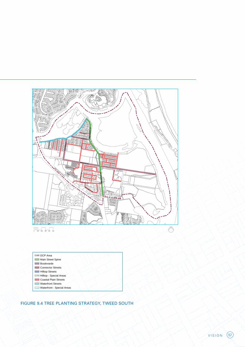
57V I S I O N
DCP AreaMain Street SpineBoulevardeConnector StreetsHilltop StreetsHilltop - Special AreasCoastal Plain Streets
Waterfront - Special AreasWaterfront Streets
Tree Planning Strategy - South
0 100 200 300 400 500
MINJ
UNGB
AL D
R
MINJ
UNGB
AL D
R
SULL
IVAN
ST
LLOYD ST
OXLE
Y ST
WILLIAM ST
KIRKWOOD RD
TWEED HEADS BYPASS
SOORLEY ST
MACHINERY DR
TIER
NEYS
RD
GREENWAY DR
FIGURE 9.4 TREE PLANTING STRATEGY, TWEED SOUTH
DCP AreaMain Street SpineBoulevardeConnector StreetsHilltop StreetsHilltop - Special AreasCoastal Plain Streets
Waterfront - Special AreasWaterfront Streets
0 100 200 300 400 500
BAY ST
BOUNDARY ST
RECR
EATI
ON S
T
CHAR
LES
ST
BOYD
ST
FRANCES ST
WHA
RF S
T
BERY
L ST
PEAR
L ST
END
ST
FLORENCE ST
BRETT ST
TUPIA AVTERRANORA TCE
SOLANDER ST
HICKS ST
ADE
LAID
E S
T
KEITH COMPTON DR
Tree Planning Strategy - North
DCP AreaMain Street SpineBoulevardeConnector StreetsHilltop StreetsHilltop - Special AreasCoastal Plain Streets
Waterfront - Special AreasWaterfront Streets
Tree Planning Strategy - South
0 100 200 300 400 500
MINJ
UNGB
AL D
R
MINJ
UNGB
AL D
R
SULL
IVAN
ST
LLOYD ST
OXLE
Y ST
WILLIAM ST
KIRKWOOD RD
TWEED HEADS BYPASS
SOORLEY ST
MACHINERY DR
TIER
NEYS
RD
GREENWAY DR

58 V I S I O N
9. Environment and parks
Flagstaff Hill Precinct and Museum
The Old Pilot Station and parkland surrounds will be developed as part of the cultural/ interpretative marine park incorporating a regional museum exhibiting the cultural and riverine history of the Tweed Heads region. Preliminary designs for the museum have been prepared and envisage a building set into the hillside to minimise its impact on the landscape and views to and from the Flagstaff Hill.
The Flagstaff Hill and Museum precinct will be an important tourist and cultural resource in combination with the Captain Cook Memorial and lookout, establishing the Point Danger area as a diverse destination within the Tweed city centre and coastal zone.
Arkinstall Park Upgrade
Arkinstall Park will be upgraded to function as the regional recreation and sporting centre to service the population of the city centre and wider local government area. Proposed works include the construction of a multi- user clubhouse, tennis complex, indoor facility, grandstand & lighting and a netball complex.
Cycleway Network
Cycleway networks within the Tweed city centre will create an integrated system of on-road and off road cycle routes for use by commuter and recreational cyclists. The cycle network connects retail areas, employment and recreation destinations. To ensure cycling becomes a legitimate form of sustainable transport the cycle facilities need to be safe, convenient and well connected.
PUBLIC ART
Public art is an important way to build on the identity of the city. It has a role in way finding, to improve legibility, and in place making – interpreting the physical character and defining a cultural identity. It can also engender civic pride and promote the city’s regional and national significance. Public art is encouraged in the streets and open spaces of the public domain. The artists will work with urban designers and landscape architects at the planning stages of each project, to develop an appropriate strategy for each place.

59V I S I O N
Flagstaff Hill and Museum Precinct

DCP Area
Jack Evans Boat Harbour Precinct
Duranbah Beach & Flagstall Hill Precinct
Boat Harbour Precinct
City Centre Support Precinct
Civic/Campus Precinct
Ridgeline & Razorback Precinct
Tweed River Precinct
City Centre Core Precinct
Residential Boat Harbour Precinct
0 100 200 300 400 500
BAY ST
BOUNDARY ST
RECR
EATI
ON S
T
TS SELRAHC
BOYD
ST
FRANCES ST
WHA
RF S
T
BERY
L ST
PEAR
L ST
END
ST
FLORENCE ST
BRETT ST
TUPIA AVTERRANORA TCE
SOLANDER ST
HICKS ST
ADEL
AIDE
ST
KEITH COMPTON DR
FIGURE 9.1 NORTH TWEED CHARACTER PRECINCTS
DCP Area
Jack Evans Boat Harbour Precinct
Duranbah Beach & Flagstall Hill Precinct
Boat Harbour Precinct
City Centre Support Precinct
Civic/Campus Precinct
Ridgeline & Razorback Precinct
Tweed River Precinct
City Centre Core Precinct
Residential Boat Harbour Precinct
0 100 200 300 400 500
BAY ST
BOUNDARY ST
RECR
EATI
ON S
T
TS SELRAHC
BOYD
ST
FRANCES ST
WHA
RF S
T
BERY
L ST
PEAR
L ST
END
ST
FLORENCE ST
BRETT ST
TUPIA AVTERRANORA TCE
SOLANDER ST
HICKS ST
ADEL
AIDE
ST
KEITH COMPTON DR

61V I S I O N
10. City centre characterThe Tweed city centre is divided into a number of character precincts under this Plan (refer to Figures 9.1 and 9.2). The character statements for these precincts and the development controls under this Plan aim to develop and reinforce the vision established for each area.
The objectives identified in the Tweed
City Centre Vision are to promote sustainable growth within the Tweed city centre and encourage a city that is vibrant and active.
Character statements apply to the precincts within the Tweed city centre north area and the Tweed city centre south area.
DCP Area
Tweed River Environmental & Recreation PrecinctSouthern River Precinct
Tweed South Retail Precinct
Recreation & Public Use PrecinctMunjungbal Drive Enterprise Corridor PrecinctTweed South East PrecinctKirkwood Road West Residential Precinct
Tweed South Business Core Precinct
0 100 200 300 400 500
MINJ
UNGB
AL D
R
MINJ
UNGB
AL D
R
SULL
IVAN
ST
LLOYD ST
OXLE
Y ST
WILLIAM ST
KIRKWOOD RD
TWEED HEADS BYPASS
SOORLEY ST
MACHINERY DR
TIER
NEYS
RD
GREENWAY DR
FIGURE 9.2 SOUTH TWEED CHARACTER PRECINCTS

62 V I S I O N
TWEED CITY CENTRE NORTH
Duranbah Beach and Flagstaff Hill Precinct
Duranbah Beach is a world class surfing destination and popular local landmark. The beach is defined in the south by the Tweed River northern training wall and in the north by a manmade seawall at the base of Point Danger. The beach is the most northern beach in New South Wales and it lies on the State border with Queensland. Due to its orientation and landform separation from Flagstaff Hill the beach has a significantly different character to the cosmopolitan city beaches of the Gold Coast. The local surfing fraternity in particular is attracted to the informal and relaxed atmosphere of the area.
The natural character of Duranbah Beach will be maintained and its public domain area will be improved to cater for the high visitation in summer and at surf carnival events. The future development will be largely limited to the upgrading of the Volunteer Marine Rescue Service (VMR) with introduction of special function rooms, and a restaurant and enhanced public domain including benches, lighting, picnic shelters and change room. The popular public walkways along the beach frontage linking NSW and Queensland will be also be upgraded to a higher quality.
Flagstaff Hill is characterised by a major park perched on the highest point within the city centre and affords dramatic views to the east and south. The park is surrounded by residential apartment buildings of between three to seven storeys. Future development in the precinct will be of similar scale, with small scale cafes and local shops fronting the park. An increase in development intensity is anticipated for land parcels fronting both Hill and Eden Streets
The regional museum exhibiting the cultural and riverine history of the Tweed Heads region is planned to be constructed on public land at Flagstaff Hill adjacent to the Old Pilot Station site. To minimise impacts on the culturally significant site and to protect views from residential development the future building will be partially built into the hill. The museum will incorporate east facing, elevated public forecourt and a café.
Jack Evans Boat Harbour Precinct
Jack Evans Boat Harbour is situated at the northern end of the city between the Commercial Core and the Flagstaff Hill/Duranbah Beach Precinct.
The boat harbour area is the primary, but underutilised open space and community focus area within the city centre. The precinct is generally flat and its protected waters are ideal for the recreation activities of older age groups and families with children. The harbour is dominated by the Twin Towns club building and the twenty four storey Seascape residential tower.
The future character of the Jack Evans Boat Harbour precinct will be as the recreational and tourism centrepiece for the Tweed city centre. The precinct will become a major park with a series of destinations in the form of complementary mix of diverse uses that will activate the area day and night, and cater for all ages.
The land use and development controls for the precinct aim to establish a high profile point of difference to the Gold Coast beach environment. The precinct will include areas for passive and active recreation that caters for the needs of the diverse range of user groups and community desires for the land.
10. City centre character

63V I S I O N
The new development framing the harbour to the north will consist of a mixed use building along Coral Street which will have tourist uses and cafes facing the harbour. The Twin Towns Club to the north east of the harbour will have improved public address to the harbour and some active uses at ground level.
Specific public spaces within the harbour parkland will include the Indigenous Place project, playground areas, public plazas, market spaces, promenades, boardwalks, BBQ areas and a marina facility with associated tourist/cultural centre in the north eastern corner of the harbour.
City Centre Core Precinct
The City Centre Core Precinct is the ‘heart of the city’ and is well located to accommodate the bulk of future residential and business development necessary to fulfil the regional centre role of Tweed Heads while connecting with the existing urban form of Tweed Heads and Coolangatta.
The future character of the City Centre Core Precinct will be of a dynamic centre with a mix of land uses comprising retail uses at ground level activating the street frontage and podium levels comprising commercial offices topped by residential high rise buildings ranging from 10 to 14 storeys in height. The main two streets in the precinct are Bay Street and Wharf Street.
The visual and functional character of Bay Street and Wharf Street will be improved through enhancements to the public domain in the form of integrated planting, paving, lighting and street furniture schemes framed by high quality buildings. Streets will have continuous awnings to provide weather protection to pedestrian street activity.
Tweed River Precinct
The Tweed River Precinct adjoins the western bank of the Tweed River, extending from the Jack Evans Boat Harbour Precinct, to the Civic/Campus Precinct and to Powell Street in the west. The area is predominantly on reclaimed land from the former Greenbank Island and Back Channel.
The future character of the precinct will be of a high quality residential area with a small component of mixed business uses along the riverfront park. The future development will respond to the environmental and recreational qualities of the Tweed River and will reinforce the nexus between the City Centre Core and the Civic/Campus Precinct.
The built form in the precinct will maximise the view sharing with higher buildings away from riverfront and lower along the river.
The residential buildings will have generous balconies and roof terraces and will be surrounded by landscape.
City Centre Support Precinct
The City Centre Support Precinct is located to the south of the City Centre Core and adjoins the Ridgeline and Razorback Precinct, the Tweed River Precinct and the Civic/Campus Precinct and the Southern Boat Harbour Precinct.
The objective for future development in this precinct is to allow for a similar range of land uses to the City Centre Core although at a lower density and without the extent of active street front uses as in the City Centre Core.

64 V I S I O N
Future development on consolidated allotments will be up to 10 storeys fronting Wharf Street and 14 fronting Pearl Street with residential land uses only to the west of Beryl Street and Boyd Street. The objective for future development west of Beryl Street and Boyd Street is to create a residential precinct with high quality urban design and buildings that respond to the topography of the land. Buildings up to 10 storeys will be encouraged along Thomson Street on consolidated sites to reinforce the ridgeline and define the State border. Some medium density buildings between Angela Street and Florence Street will function as an interface between City Centre Support Precinct and lower density Ridgeline and Razorback Precinct.
Ridgeline and Razorback Precinct
The Ridgeline and Razorback Precinct is located on the western edge of the city centre, generally west of Recreation Street. Development in the precinct is predominantly single detached dwellings stepping up the escarpment to take advantage of easterly views.
The development controls anticipate minimal changes to the precinct with a two storey height limit for the majority of the precinct and some medium density buildings on the flatter areas east of Adelaide Street.
Civic/Campus Precinct
The Civic/Campus Precinct primarily supports community related facilities such as Tweed Heads Hospital, Tweed Heads Bowling Club, Civic Centre Library, Southern Cross University, and St Cuthbert’s Church. This precinct has a built form and architecture distinct from the rest of the Tweed city centre which reflects its predominantly civic and community role and function.
It is proposed that the future character of the precinct largely maintains the existing civic character, and new buildings to contribute to the campus theme with a network of landscaped pedestrian through links and new public squares linking the Tweed River to Wharf Street. The future development should address well the surrounding streets and define well the new public squares within the precinct. Additional car parking opportunities should be sought within the precinct to reduce the on street car parking pressure on streets surrounding the precinct.
Future multi deck car parking within the precinct should have active uses on ground level facing streets and internal squares and have attractive screening to the upper levels to conceal the parked cars.
The precinct has the potential to develop some tourist accommodation to cater for the Bowling Club and the Tweed Hospital needs. In particular along the river frontage and along the Wharf Street.
The expansion of the university functions in this precinct would be most desirable.
Boat Harbour Precinct
The Boat Harbour Precinct is the southern gateway to the Tweed city centre just north of the Boyds Bay Bridge and Terranora Terrace. The precinct has distinctive character of the former Monastery Hill and the adjoining intimate Boat Harbour which functions as a popular tourist destination and as the boat maintenance area. The objective for this precinct is to promote the maritime theme of the Boat Harbour and provide pedestrian access along the waterfront and to water based tourist activities. At the land water interface low scale commercial activities such as restaurants, cafes and tourist activities and facilities are encouraged.
10. City centre character

65V I S I O N
To make an entry statement as people enter the precinct over the Boyds Bay Bridge landmark buildings up to 13 storeys are encouraged on key sites on northern side of Terranora Terrace and on Monastery Hill and could accommodate a mixture of business and residential uses and tourist accommodation.
A continuation of the mixed retail and residential development from the northern end of the City Centre along Wharf Street is promoted with buildings of eight storeys stepping down to six storeys on the eastern side of Recreation Street.
Residential Boat Harbour Precinct
The Southern Residential Precinct extends southwards from the Civic/Campus Precinct and comprises two distinct areas. South of Keith Compton Drive is predominantly newer small lot residential housing designed to take advantage of the estuarine environment with the northern area comprising older medium density housing stock.
The development controls provide for minimal intensification in this precinct with the redevelopment of older stock in the northern sector promoted through provisions that allow four storey residential buildings. Redevelopment within this precinct should be of high quality residential design and take advantage of the proximity to the Tweed River through the use of large balconies and terraces.
66 V I S I O N
TWEED CITY CENTRE SOUTH
Because of the amount of flood prone land in the area, the vision for Tweed city centre south depends upon the findings of Council’s Floodplain Risk Management Study.
Tweed River Environment & Recreation Precinct
The Tweed River Environment and Recreation Precinct is the major natural area within the Tweed city centre and comprises significant wetland areas, watercourses and the golf course. It has significant biodiversity value and development should be minimised to land uses that compliment the natural qualities of the precinct, and have tourist or recreational qualities.
Southern River Precinct
It is intended that the existing residential character of the Tweed South River Precinct will be retained. Existing development controls permit four storey residential buildings on consolidated allotments in this area.
The attractiveness of these areas for tourist accommodation will be improved through the upgrading of this section of Minjungbal Drive as a boulevard and enhancements to the riverfront park on the eastern side of the Minjungbal Drive. Existing businesses in this precinct are more suited to higher exposure areas and will be encouraged to relocate southwards to the enterprise corridor on Minjungbal Drive.
Recreation & Public Use Precinct
The current role and function of this precinct will be reinforced with major upgrades to playing fields and public facilities in Arkinstall Park.
Minjungbal Drive Precinct
The precinct is intended to focus business activities that require larger footprint buildings, good vehicular access and exposure along Minjungbal Drive south of the Tweed South River Precinct.
The area will cater for businesses requiring main street frontage as well as complementary business, office, retail and light industrial uses.
The character and visual appearance of the precinct will be enhanced through controls promoting the consolidation of allotments, the coordinated locations, extent and type of advertising signage and the relocation of car parking and storage and service areas to the rear of buildings away from street frontages. This will be in conjunction with the upgrading of Minjungbal Drive which will include widened footpaths where the high level of pedestrian activity will happen in particular along the Tweed City Shopping Centre and tree planting to define and soften the main gateway to Tweed city centre.
Tweed South East Precinct
The Tweed South East Precinct will remain a residential area with one and two storey houses.
The development controls do not propose any change within the residential areas to the south of Kirkwood Road.
Kirkwood Road West Residential Precinct
This precinct will remain a residential neighbourhood. The residential estate at the western end of the precinct will include planning controls that retain its current character and land use. New enhanced pedestrian links will better connect this precinct with surrounding areas.
10. City centre character

67V I S I O N
Tweed South Retail Precinct
The Tweed South Retail Precinct comprises the Tweed City Shopping Centre which is the main retail centre within the region. The development controls for the precinct provide for the expansion of the existing centre up to Munjungbal Drive and to Kirkwood Road frontages. Opportunities exist for Minjungbal Drive to be revitalised into a dynamic street with a mixture of new retail, showcases and articulated facades fronting Minjungbal Drive and Kirkwood Road as an extension to Tweed City Centre. As redevelopment / expansion proceeds towards the Minjungbal Drive frontage, a new public plaza that provides connectivity between the Centre and areas adjacent can be created. The pedestrian access to the shopping centre will be clearly defined. All carparking will be readily identifiable and should incorporate articulated street frontages / screening which can enhance the future visual character of Minjungbal Drive and Kirkwood Road.
Tweed South Business Core Precinct
The Business Core Precinct is an area in transition from a traditional industrial area to a mixed use business area comprising bulky goods and showroom uses interspersed with warehouses and modern light industrial unit complexes.
The development controls for the Tweed South Business Core Precinct seek to manage this transition by encouraging the redevelopment of older factory premises into modern showroom and bulky goods premises similar to those on Greenway Drive to the south of the Pacific Highway. The visual and functional qualities of the precinct will be enhanced through the provision of unified landscaping throughout the precinct, the relocation of car parking from front setbacks, a reduction in advertising signage and clutter and a new road access linking Rivendell and Machinery Drive.


69V I S I O N
11. Future actions1. ACTION
Promote office (re)development in the commercial core
Rationale
Recent shirewide Council strategies for employment land have identified a general shortfall in commercial floor space within Tweed Heads, with residential and tourist development dominating the city centre. To accommodate the projected 3,000 jobs, an emphasis on the creation and positioning of commercial development will be required. More sites have been made available within this plan for new office and mixed use buildings to allow for the expansion of white collar employment, as well as new cultural and recreation facilities. The focus of new office investment is to be primarily directed to the Tweed Heads commercial core and will result in flow-on effects to local retail and food outlets, as well as revitalising public squares and open space.
Tweed Shire Council will collaborate with key stakeholders in developing strategies to ensure the continued growth of high quality commercial office space, development and operations in Tweed Heads.
2. ACTION
Develop a learning city strategy with particular interaction with the Tweed Hospital and medical facilities.
Rationale
Education can play a much greater role in the future life of the city centre. This is important not just from the point of view of increasing and diversifying activity, but also to build the skills and knowledge capacity of the local labour force and economy.
A Learning City Strategy will be developed in partnership with education providers and key local employment providers. This will investigate options for increasing the tertiary education presence in the city centre, and interactions with business, particularly the Tweed Hospital and associated medical facilities.
Opportunity exists for Council to play a pivotal role in developing a strategy that maximises the employment opportunities associated with the university and strengthens the physical and intellectual linkages between the university, industry and the broader population.
3. ACTION
Review and develop transport management strategies with particular emphasis on supporting and fostering alternate forms of transport.
Rationale
At present, public transport patronage within the study area is low, with private vehicle transportation being the dominant method of transport. Numerous reasons contribute to the current transport scenario including ease of parking, fragmentation of employment, residential and recreation areas and relatively low density housing. This plan, as well as other recent Council policies, emphasises a push towards decreasing car dependency and creating a more sustainable living environment through urban consolidation. Beyond this plan, additional work is required to further facilitate the integration of transport and land use as well as provide additional support through improved pedestrian links, cycleways and effective use of public transport.

70 V I S I O N
4. ACTION
Investigate how to expand the cultural events calendar with a focus on celebrating the water’s edge.
Rationale
Tweed Heads is evolving into a city of cultural celebration. A number of recent projects and masterplans seek to further embrace different cultural features and events such as the Flagstaff Hill Museum and numerous features within the Jack Evans Boat Harbour Masterplan. With a further growing population, both in Tweed Heads and its neighbours, there are further opportunities emerging for increased cultural infrastructure, both in the city centre and along riverside open space areas. Significant opportunities are afforded to further link and integrate key cultural infrastructure with both structured and passive recreation areas. Council and other relevant stakeholders should work together as a study group to look at ways of further strengthening Tweed’s events and cultural offerings.
5. ACTION
Further develop a strategic plan for the integration of the city centre with the Tweed River
Rationale
The urban form of both Tweed Heads and Tweed Heads South follow the path of Tweed River, which affords significant areas of open space through water activities and linear parks. Whilst these areas possess high scenic value and enjoy minimum geographical separation from the urban footprint, outside the commercial core area of Tweed Heads, neither area strongly integrates the urban form with these valuable natural areas. Further strategic planning is to be undertaken to strengthen links between the city and development form and the expansive open space areas. Particular
attention should be focused on appropriate maintenance of views and vistas from civic areas, co-ordinated pedestrian links and public domain improvements.
6. ACTION
Facilitate the development of key sites
Rationale
The Tweed City Centre Plan identifies a number of strategic sites included within the study area. Given developer perspectives on commercial risk, Council should take a lead role in facilitating and guiding development. The significance of these sites for the future form and character of the city centre warrants the preparation of site specific planning controls to guide and ensure a high level of design and development outcome. Architectural competitions are required for these sites. Additionally, there is a need to take a proactive stance in establishing appropriate development on these sites through establishing and maintaining dialogue with owners/developers, assisting in the design and development process and assisting in brokering projects to fruition.
7. ACTION
Develop strong partnerships with State Government to develop highest standard Public Domain improvements and outcomes.
Rationale
Many landmark sites within the study area are under the control and ownership of State Government. These sites have the ability to help shape the standard and context of various precincts as well as contribute significantly to the amenity and well being of Tweed residents. The State Government is currently reviewing a number of the parcels in their ownership and
11. Future actions

71V I S I O N
developing plans for their future use. Council should take a proactive role in working with State Government on these projects to ensure highest quality outcomes are met throughout all stages, visioning, masterplanning and implementation. A strong partnership between Tweed Shire Council and State Government will help provide appropriate integration of these key sites into the function of the locality and satisfy the desires of the wider public.
8. ACTION
Foster new tourism development opportunities.
Rationale
The waterfront location and comfortable climate of the city centre make Tweed Heads an attractive tourist destination. Development opportunities and strategies for the city centre to encourage tourism should be investigated and assessed by Council, Tweed Tourism, and other relevant stakeholders.
9. ACTION
Development of strategies and plans for council-owned buildings within the Civic Precinct.
Rationale
Council has previously undertaken a masterplanning process for the Civic Precinct, in conjunction with the relevant landowners, to explore the potential for growth in government office, medical support, tertiary and student accommodation space. Council should re-investigate these discussions surrounding these options, and seek to push forward with specific plans for the redevelopment of buildings under its ownership within the precinct. Numerous opportunities are present to continue the evolution of this precinct and create a key space, supporting the Tweed Heads Hospital, providing quality cultural facilities and increasing public
access to government offices and community facilities. A development brief should be prepared meeting Council’s needs and the objectives of the Civic Precinct Masterplan. A feasibility plan will also be required which should explore opportunities of effectively involving private development partners while meeting public objectives.
10. ACTION
Develop a business improvement plan for activating a Southern Gateway and facilitating the appropriate evolution of the Minjungbal Drive and Machinery Drive precincts.
Rationale
Both Minjungbal and Machinery Drive hold increased importance into the function of South Tweed and Tweed Heads into the future. Minjungbal Drive provides the gateway to both North and South Tweed Heads and is a major collector road for vehicle movements. At present Machinery Drive represents a distinctly unhuman environment with very little pedestrian amenity, dominance of private vehicle movement and minimum street address. As these areas progress, a business improvement plan is to be developed by Council and relevant stakeholders to ensure the appropriate evolution of land uses along both Minjungbal and Machinery Drive and that both incoming and outgoing businesses are adequately catered for.
Particular emphasis should also be given to co-ordinating the built form along Minjungbal Drive to ensure a higher level of street address, pedestrian connectivity, co-ordinated advertising and signage and increased streetscape works to properly represent the southern gateway that it provides to Tweed Heads. These plans should be accompanied by streetscaping guidelines, increased support of alternate methods of transport than the private car and pursuance of activities operating outside of core business hours.

72 V I S I O N
11. ACTION
Review and update planning controls in light of additional climate change and flooding data.
Rationale
Much of the Tweed Heads and South Tweed Heads area is identified as flood prone land. Council’s current flood model, that established existing flood levels, is currently being re-run to incorporate climate change (sea level rise and increased rainfall) variables set out in the Department of Environment, Climate Change and Water’s 2007 Guideline “Practical Consideration of Climate Change”. The detailed examination of options relating to future land use planning in light of flood plain management data, taking into account climate change factors is necessary. Council, in conjunction with key stakeholders and the State Emergency Service will develop appropriate land use and implementation strategies for flood prone land at the conclusion of Council’s Flood Risk Management Policy.
11. Future actions

73V I S I O N
74 V I S I O N
12. References
Regional Context
Department of Planning (2006), Far North Coast Regional Strategy
Historic Context
Tweed Heads Taskforce (2004), Tweed Heads Town Centre Masterplan
Demographic/Housing Context & Economic development
Tweed Economic Development Corporation (2007) The Tweed Ready for Business Economic Growth Management Strategy 2007-2010
Tweed Heads Taskforce (2004) Tweed Heads Town Centre Revitalisation Economic Development Strategy
Tweed Shire Council (2007) Tweed Employment Lands Strategy – Economic and Demand Assessment
Tweed Shire Council (2004) Tweed 4/24
Climate Change
Tweed Shire Council (2007) Flood Risk Management Strategy
COAG (2007) National Climate Change Adaptation Framework
Department of Environment and Climate Change (2007) Floodplain Risk Management Guideline: Practical Consideration of Climate Change
75V I S I O N


![A vision for [Insert centre name]](https://static.fdocuments.in/doc/165x107/56813f55550346895daa1b7c/a-vision-for-insert-centre-name.jpg)