Vision for the Danube Delta, a natural gateway to · PDF filesediments by the current and the...
64
Wildernis Consultancy drs Willem Overmars, landscape architect Rhedense Veerweg 5-12 8976 EC Giesbeek, Netherlands 0031.31.313.630.198 Willem.Overmars @wildernis.com Vision for the Danube Delta, a natural gateway to Europe Ecology and Economy in Harmony background paper 2: Development of the seaside of the delta. Understanding the system outer delta's growth and erosion of the shoreline proposals for projects and model sites 4th draft, 23rd of November 2006 Commissioned by: WWF International – Danube Carpathian Program, Vienna
Transcript of Vision for the Danube Delta, a natural gateway to · PDF filesediments by the current and the...

Wildernis Consultancydrs Willem Overmars, landscape architectRhedense Veerweg 5-128976 EC Giesbeek, Netherlands0031.31.313.630.198Willem.Overmars @wildernis.com
Vision for the Danube Delta,a natural gateway to EuropeEcology and Economy in Harmony
background paper 2:
Development of the seaside of the delta.Understanding the systemouter delta's growth and erosion of the shoreline
proposals for projects and model sites
4th draft, 23rd of November 2006
Commissioned by:WWF International – Danube Carpathian Program, Vienna

fig 1. Sulina harbour from the land side, about 1860.

Contents1.Summary..............................................................................................................52.The seaside of the Delta: Understanding the system...........................................8
2.1 The Genesis of the Delta...............................................................................82.1.1.The Danube Valley.................................................................................82.1.2. The flooded Danube Gulf......................................................................82.1.3.The initial sandy spit...............................................................................92.1.4.The five Outer Delta's......................................................................................................................102.1.5.The Sfantu Gheorghe I delta................................................................112.1.6. The Sulina Delta.................................................................................112.1.7.The Sf Gheorghe II Delta.....................................................................112.1.8.The Kiliya Delta....................................................................................112.1.9.The Razim-Sinoie lake area.................................................................12
2.2The coastal development in recent times.....................................................132.2.1.The Delta coast, tectonic sinking and the rising level of the sea..........132.2.2.Wind and waves, tidal movements......................................................................................................................142.2.3.Sediment influx.....................................................................................152.3The development of the Kiliya-delta 1778 – 2006....................................16
3. Understanding the system: harbours and canals..........................................283.1 Looking for an passage to the Danube...................................................283.2 The development of the Sulina Harbour 1778 – 2006.............................303.3 The Development of the Sfantu Gheorghe mouth 1771-2006.................403.4 Riverworks...............................................................................................474.1 Zhebrianskye ridge..................................................................................494.2 Letea Forest and Caraorman..................................................................494.3Sf. Gheorghe dunes and Grindul Saratirule.............................................55
5. Growing with the sea.........................................................................................575.1 Beaches and dunes.................................................................................57The natural system........................................................................................57The effects of the Sulina jetties.....................................................................57Bistroye and a new harbour for the Ukraine..................................................58Other solid structures in the dunes................................................................59Recommendations:.......................................................................................595.2Behind the coastline: Kiliya delta..............................................................59Mounds.........................................................................................................605.3 Behind the coastline: the drowned delta's and their islands....................60Recommendations:.......................................................................................616. Projects and Model sites...........................................................................616.1 Opposition against Bistroye Canal..........................................................616.2 Study for an alternative Ukranian harbour...............................................616.2Study on Sulina harbour...........................................................................616.3 Dykes or mounds....................................................................................626.4other model sites or projects....................................................................627. literature:...................................................................................................63


1. SummaryThe seafront of the Danube Delta (fig 2) is a very dynamic environment. Here the forces of the river and the sea work together in the formation and continuous change of the landscape. Several river mouths in time changed in importance. Different sub-deltas have been formed and have been partly eroded away again. At this moment two river branches are forming expanding delta's: the Kiliya branch in the north, (Kiliya Delta) and the Sfantu Gheorghe branch in the south (Sf. Gheorghe delta II). These two river mouths are very shallow, and many sandbars and island are blocking the passage between sea and river. In the 19th century, the great powers of western Europe were in need of vast amounts of grain for their expanding populations. Hence a new passage to the Lower Danube, and thus to the plains of Romania, was needed. The harbour of Sulina in the end was chosen.
Although in the 19thcentury there were several plans to construct a canal through the Kiliya Delta, or from Zhebriansky bay to the river Danube, these plans all were abandoned. This is the reason why the Kiliya Delta still is in a very natural state.Ships for the Ukranian harbours since 1858 pass through the Sulina harbour and river on Romanian territory. The Ukrainian government wants to construct a connection between the Black Sea and the River Danube on Ukrainian territory. The Bistroye-branch in the Kiliya Delta was chosen as the most suitable to dredge a new entry. The very nature of this river mouth implicates however, that large amounts of sand will have to be removed every year, a very costly and ever repeating solution. Moreover, opening Bistroye mouth and dredging the entrance will heavily effect the natural behaviour of the Kiliya-coast. The construction of jetties would be necessary, and that would change the morphology of the coast completely. In fact, to be successful, the other mouths of the Kiliya would have to be closed, to concentrate all the water on the one with the jetties. This unfortunately
happened to the Rhone and the Mississippi deltas in the 19th century, thereby destroying the natural systems of these deltas.

On Ukrainian territory the area north of the Kiliya delta, the Zhebrianskye bay in front of Sasyk Liman is a quiet, relatively deep water, with the least sedimentation. From there a connection to the Danube to the village of Leski could be made along the existing irrigation-canal..Technically the best and cheapest solution for the connection between the Black Sea and the River Danube however is to continue the use of Sulina Harbour and the Sulina river branch.In the project a more detailed study of the possibilities to provide the Ukraine with a sea-river connection on its own territory will be studied.
The Sfantu Gheorghe branch is still in a very natural state.
The amount of sediments transported to the Danube Delta increased sharply in the 19th and early 20th century as a result of the massive opening of the Romanian soils for grain production. It decreased dramatically in the second half of the 20th
century. From 67.5 million tons/year in the period 1921 – 1960 , to 41.3 million tons/year in the period 1971 - 1980 , to 29.2 million tons/year in the period 1981 – 1990.The Kiliya branch especially suffered from a loss of water and sediments, as already in the 19th century works at the division point between the Kiliya and the other branches did sent more water and sediments to the Sulina branch.
The Sulina Harbour was constructed in 1858, with jetties that forced the sediments into deep parts of the sea. These jetties were elongated several times. By now they are 8 km long, and the area to the north of it will soon be completely silted up.In fact, the jetties have trapped the sediments from Kiliya delta, and soon will become a problem in the further development of the delta.
The survival of the Danube Delta on the (very) long term depends on the amounts of sediments that can be used to compensate for the combined effects of a rising sea and a sinking land ( together about 1 m / century). Sediment influx in both the coastal area and the inner delta can prevent the drowning and erosion of the delta in the future. If enough sediment is available the delta is perfectly able to maintain itself through natural processes of siltation and sedimentation. To be able to grow with the sea, in the first place the natural processes must be function without constrictions as dykes and dams. In the second place the amounts of sediments brought to the delta by the river must be maintained or, better, restored.
Recommendations:
1. Do not open a new passage from the Black Sea to the Danube. Continue the use of Sulina Harbour and Sulina branch for shipping.
2. If a separate Ukranian harbour on Ukranian territory is necessary, look for a passage from Zhebrianskye bay to the Danube near Leski.
3. Further the use of Konstantsa harbour as an alternative for Sulina as much as possible.
4. Allow the coastal area to change its morphology according to the natural forces of the sea, the river, the current and the wind. This will allow the seaside of the Danube Delta to “ grow with the sea” .

5. Defend inhabited places along the coast against inundation not by dykes, but by gradually changing to living on mounds.
6. Remove useless dykes7. Further the amounts of sediments brought to the Black Sea through the
different branches.
Projects:1. Awareness Campaign to the (international) organisations which protest
against a passage at Bistroye or Ochakow/Prorva on the morphological arguments
2. Propagation of Sulina harbour as the best passage between Black Sea and danube
3. Orientation on an alternative passage to the Danube in the Ukraine4. Orientation on the future of Sulina harbour5. building on mounds in stead of behind dykes: awaraness and model site in
combination with i.e. ecotourism.6. Removing dykes almost completely: Popina Model Site.

2. The seaside of the Delta: Understanding the system
2.1 The Genesis of the Delta
2.1.1.The Danube Valley
fig 2: Paleo-Danube Valley with tributaries 12.000 BP
About 13.000 – 12.000 Years ago, the water level of the Black Sea was between 80-100 m lower than at present. The Delta of the Danube was located hundreds of kilometres to the southeast. At the present day location of the Delta, there was a valley cut into the sediments the Danube had accumulated there in earlier geological eras. From the Budzak plateau in the north and from the Dobrogea hills in the south, tributary rivers formed their own valleys towards the main Danube valley.
2.1.2. The flooded Danube Gulf
fig 3. The flooded Danube Gulf about 10.000 BP
About 10.000 BP the level of the Black Sea rose sharply to about present day level. There is a theory that this rather sudden event was caused by an overflow of water from the Mediterranean to the Black Sea through Bosporus / Dardanelles. This could be the big Flood in the Gilgamesh-epos or the biblical Flood. More likely, however, is a rise of the level of the sea in several stages over a longer period. The valley of the Danube was flooded with salt water. To the North, the lower part of tributary valleys became inundated as well (the limans as they are called today)

2.1.3.The initial sandy spit
fig 4: The Danube Gulf divided by the initial spit
In the Black Sea, a circular current flows. Near the Danube Delta, it comes from the north, and carries eroded sand from the coasts of the northern Black Sea and from the rivers Dnestr and Dnjepr. The bays of several drowned river valleys along the coast became closed of from the Sea by a small sandy ridge. The larges of these bays, the Danube Gulf, was closed by a sandy spit between the promontory of the Budzak plateau at Zhebriansky, and the promontory of the Dobrogea hills at MurighiolThis divided the Danube Gulf in two distinct parts. West of spit, a freshwater
lagoon formed, and here the river dominated the natural system. This freshwater lagoon gradually silted up, and , in fact, is still silting up. East of the spit, the sea dominated. Here large delta's were and still are formed of both marine and riverine sediments by the current and the waves of the sea. The waters of the Danube initially flew to the sea at the southernmost part of the sandy spit.

2.1.4.The five Outer Delta's
fig 5: the five Outer Delta's of the Danube
At the sea side of the sandy ridge, in the past 10.000 years, at least five different delta's have been formed, or are still being formed.

2.1.5.The Sfantu Gheorghe I delta.
(fig. 5)The initial sandy spit had an opening in the southern part of the spit, near Murighiol. Here sediments from the Danube flew into the Sea, and were transported southward by the current.South of the river mouth a series of more or less parallel sand ridges developed,as is still is happening today at the Sf Gheorghes II river mouth. The temporarily reverse current brought some sediment to the north of the river mouth, but most of the sediment there was brought by the sea current from the north. Thus, the delta was, regarding the provenance of the sediments, asymmetric. The northern part consisted of sea-borne sediments from the Black Sea coast, and the southern part consisted of materials from the river Danube. Sf Gheorghe 1 delta was formed between 9000 – 7200 years BP.
2.1.6. The Sulina Delta
(fig 5)At the end of this period, the sf Gheorghe arm silted up. A new river branch, the Sulina branch, broke through the sandy ridge, and developed a new delta more to the north. The process of asymmetric delta formation repeated itself. The Sulina Delta developed. It extended to a point about 15 km east of the present coastline. In the period 7200 – 2000 BP. The Sulina branch eventually silted up as well. Now due to both the lack of sediments and the rise of the level of the sea, large parts of the Sulina delta were eroded or drowned. ( 2000 – 0 BP)The process of erosion is still going on, strengthened by the fact that the jetties of Sulina harbour bring the sediments of Sulina arm to a point far from the shore, where the sediments sink to the depth of the sea, out of reach of the coastal current.The average retreat of the shoreline is 17.5 m/year between Sulina and Sf Gheorghe.
In the south, in the same period the smaller Sinoie delta was formed, and partially eroded away.
2.1.7.The Sf Gheorghe II Delta
(fig 5)About 2000 BP a new Sf Gheorghe branch became active again. A new Delta developed, and again the southern part of the Delta consisted mainly of riverine sediments. The northern part was built up by eroded materials of the Sulina Delta.This process is still going on, as can be seen in the case of the Sakkalin peninsula that is still developing.
2.1.8.The Kiliya Delta
(fig 5)About 1800 (200 BP), a new Delta outside the initial spit started to develop near the mouth of the youngest and at this moment strongest river branch of the

Danube Delta, the Kiliya-arm. In a rather sudden growth in 200 years an asymmetric outer delta developed in the Zhebrianskye bay. A peak in sediment transport in the Danube in the 19th and early 20th century, caused by the plowing up of the soils of the plains of Romania, brought enormous quantities of sediments to this part of the delta. The Kiliya branch of the Danube divided itself in several side branches. The form of this delta differed strongly from the other delta’s. In the next chapter this will be explained in more detail.
2.1.9.The Razim-Sinoie lake area
(fig 5)South of the Sf Gheorghe II delta, a new, and younger sandy ridge developed out of the mixed sediments that came from the north, and sediments of local deltaic formations. (Sinoie Delta)

2.2The coastal development in recent times
2.2.1.The Delta coast, tectonic sinking and the rising level of the sea
The Danube Delta is situated in a tectonic active area. In fact, it sinks by a rate of 1-2 mm year (Hanganu 2002-1 p 13) or 1 meter in a century. The expected rise of the level of the sea is in the same order of magnitude. This means that the vulnerability of the Delta for drowning during the next century is rather large.As long as the coastal area is fed by ample sediments, the natural process corrects both the sinking of the land, and the rise of the sea. It simply brings the sediment to a higher level at the coast, and it replaces the sediments in the zone before the coast.
If new sediments are not brought into the system by the sea current or the river, sand-hunger starts to develop. The sand at the deepest part of the shore becomes unreachable by the current and the waves because of the greater net water depth. So those sands are lost for the system. The sea will compensate this by taking up sands nearer to the shore. This causes the shore to become steeper. At the end of the process, the sea starts to take sands from the shore and the dunes itself.
Fig. 6: Currents along the coast of the Danube Delta
As this happens, a growing coast changes into a retreating coast. If enough sediments are available, sedimentation compensates this: a delta has a self-defence against drowning by its ability to grow with the sea.The Black Sea Current near the Danube Delta shore from: Monteanu, 1996-2 p 39:“ The atmospheric circulation and other hydrological and morphological factors give rise to a general cyclonal water circulation, within the upper water layer down to about 1,000 m, in the Black Sea. In the north-western and western areas of the sea, the longshore drift
current associated with the cyclonal circulation gets its movement impulse from the water discharged from the rivers debouching into this area (Dnepr, Southern Bug, Dniester, Danube). This current which is 50-75 miles wide flows southward to the Bosporus at a mean speed of 20-30 cm/s. The strong gusty winds from northern directions double or even triple the speed of the current, while those from southern directions diminish and deviate the currents from the general circulation system. In the littoral area of the Danube Delta, there is, even during calm periods, usually a southward current with velocities of 5-50 cm/s depending on the water supply from the rivers. In addition to this current, the wind with a different velocity

and stability generates a complex current system generally corresponding to the wind direction. These wind currents become stable, strong and affect the whole of the water layer down to a depth of 40-50 m only when the wind velocity exceeds 10 m/s and lasts longer than 10-12 hours. The velocity of the wind currents reaches 100-150 cm/s at the surface and more than 30- 40 cm/s near the littoral sea bottom. The prevalence of strong winds from the northern directions results in a doubling of the annual frequency of southward currents compared to the frequency of northward currents. The morphological features of the seashore determine the local perturbations of the longshore wind current system. Thus, under the influence of northern winds, the jetties of the Sulina tributary, extending far offshore (approx. 8 km), generate an 8-10 km diameter long ellipsoidal anticyclonic eddy of direction situated to the south of the above-mentioned jetties. The fluvial outflow has to be added to these marine currents. The fluvial outflow penetrates into the sea basin like a turbulent jet, spreading offshore and being deviated southwards (Bates, 1953). With respect to the Danube Delta seashore, the long shore drift current flows towards the south. Its intensity is high enough to transport the coarse-grained discharge from the Danube many tens of kilometres south of the mouths of the distributaries along the shore. The shift of a contrary direction to the longshore drift, caused by reverse winds, makes it possible that the river-borne sediments occur on the opposite side to the drift-direction side of the river mouth. This area is called “zone of littoral diffusion”, and in the case of the Danube distributaries, it lies to the north of their mouths and extends only up to a few kilometres. Another local perturbation of littoral sediment movement is induced by the eddy circulation south of the Sulina jetties. The southward longshore drift of the Danube sediment load can be seen in the entire Holocene evolution of the Danube Delta.”
2.2.2.Wind and waves, tidal movements
“ Winds exceeding 2 m/s are recorded for 80-90% of the year, winds exceeding 6 m/s for 30-55% and those exceeding 11 m/s for 4-15%. The prevailing winds are from the northern directions (40-50% of the time); these northern winds are also the strongest. The frequency and duration of storms from the northern directions are clearly predominant (55%).” “ The waves below 0.2 m are calm (smooth) and they represent 49.1% of all the data concerning the waves. The other two are wind waves (33%) and swell (17.9%). The most frequent wind waves are recorded along North East-trending, corresponding to the prevailing wind direction, while from the east almost 40% of swell waves are recorded, due to the refraction of waves in shallow water. The mean and maximum heights of wind waves (5.2 m at Konstantsa, 7.0 m at Sulina at the jetties end) and swell are higher in the eastern direction in which the wind reaches its maximum.” (from: Monteanu 1996-2 p 38)Storm surges may cause a rise of the sea of 1.2-1.5 meter. The tide has amplitude of no more than 7-11 cm.
This means that heavy and dangerous storms regularly occur at the Danube Delta coast.

2.2.3.Sediment influx
The river Danube carries every year 30 million tons of sediments to the Delta. Only silt and fine sands reach the delta, due to the low velocities of the current in the extremely flat Danube Delta. 1.5 million tons is sedimented in the delta itself, and is thus used for the vertical growth of the Delta. By far most of the sediments is not used in the delta, but just passes it. The remaining silt disappears into the Black Sea. The remaining sand is used for the expansion of the delta. The amount of sediment influx to the Delta has decreased sharply during the twentieth century. From 67.5 million tons/year in the period 1921 – 1960 , to 41.3 million tons/year in the period 1971 - 1980 , to 29.2 million tons/year in the period 1981 - 1990 . (Monteanu 1996-2 p 27)
In the 19th century, the vast plains of Romania were used for the production of grain for the vast growing population of western Europe. Opening up the soils of these plains, caused a strong increase in erosion. This resulted in a rather sudden increase in sediments in the river. The high discharge of sediments in the beginning of the 20th century is partly a result of the new agricultural practices. To some extent the decrease in sediment transport after 1960 can be seen as a return to a more normal situation.
This decrease is caused by the construction of dams in the tributaries of the Danube, and in the Danube itself.Nevertheless seems the amount of sand that reaches the coastal sandbar in the Kiliya and the Sf. Gheorghe Delta's enough to keep these delta's growing. The mean annual growth of the Kiliya Delta is about 40-80 meters/year for the last 100 years.

2.3The development of the Kiliya-delta 1778 – 2006
The maps of 1771 and 1778
Two maps, of 1771 (left) and 1778 (right) mark the early years of the town of Vilkovo and the Kiliya Outer Delta. The first one is in Russian language (University of Leiden, Netherlands), and the second one, which seems to be a copy, in German language (National Archiv Wien). (figs 8 and 9). The coast of the Black sea on these maps is the eastern side of Letea Forest (Grindul Letea), a large sandy island in the delta, partly belonging to the initial spit, partly belonging to the Sulina delta. Before the coast of “Lipovenskaya” (the city of the Lipovenes, later Vilkovo) a few islands are indicated, surrounded by shallow areas. According to Panin, 1989, The Kiliya branch started to develop 3000 BP, and there was a seaside delta. This early delta, however, was completely covered by the Kiliya delta that developed after 1800.There wasn't much difference around 1770 with the other river mouths in the delta, which showed a similar configuration with a shallow sandbar in front of the river mouth. (fig 9, soundings in Klaster = 1.89 m)

The British map of 1856/57Fig 10. Kiliya Delta and Sulina mouth 1856. (soundings in feet = 0,3048 m)
In the years 1856/57 the British Navy send H.M.S Medina to the Danube Delta, to make an accurate map of the coast, the riverbranches with soundings, cities and villages and hills of the Danube Delta. (fig 10). This map in later years has been updated several times, and has been the basis for many other maps. (Österreichische Nationalbibliothek, Wien. Edition 1861)The Kilya delta appears on this map already well developed. Remarkable is that the morphological form of this delta is quite different from the one of the other delta’s of the Danube.Earlier delta’s (SF Gheorghe I and Sulina) and even the other contemporary delta (Sf Gheorghe II) are build up by series of sandbanks, more or less parallel or under a slight angle to the coastline, and perpendicular to the one main
riverchannel. (fig 5). In these cases, the sediments brought by the river were redistributed and mixed with sea-born sediments.The forces of the sea, the current, the waves and the wind in the end determined the morphological forms of the parallel sandbanks of a typical triangular delta.The morphology of the Kiliya-delta shows, that this formation was driven by riverine forces. The main Kiliya branch without doubt has the same shallow area in the river mouth as are to bee seen on the maps in figs. 11-17. The river however apparently was strong enough, to cross this sandbar at several places. Water and sediments flew in several directions into the sea. Moreover, before the actual coastline a large shallow area had been formed.At this point, the sea was not strong enough to rework these sediments in its own morphology of sandbanks parallel to the coast and perpendicular to the river. On the contrary, the river branches were strong enough to develop river-like structures kilometers far into the sea, with riverbanks parallel to the river branches, and perpendicular to the coastline.The cause of this phenomenon is a mix of the following factors:
- The amounts of sediments had become very large after the change towards grain production on the plains of Romania.
- at this point the current in the Black Sea changes direction from east – west to north-south. Perhaps it didn’t follow the coast along the coastline itself, but made a shortcut more seaward. As a consequence, the current would have been less strong at the Kiliya mouth, and at full strength again further south, where it hit the coast again at Sulina.
- The area where the Kiliya delta developed, the Zhebrianskiye bay, was

shallow in itself. As a consequence, less sediment was needed to fill up the deeper parts before the coast.
On the British map of 1856 clearly the different river branches can be seen. At the Ostrakov branch the seaward expansion with lateral riverbank development is visible. To the south the Stambul-branch developed, with numerous side-branches.Along the riverbranches, on the riverbanks, alluvial gallery-forest are indicated. The areas between the riverbranches are filled up by reed lands, and lakes. At the west side, the area between the Stambul-branch and Letea Forest is already filled up half way.Around the whole of the Kiliya delta, on this map a shallow area is visible, with depth of only 1 ore 2 feet (0,30-0,60 m) and up to 2 km width. At several places periodically dry sandbanks are indicated as well.This means, that in 1856 the Kiliya delta was in full expansion seaward.
The explosion-like development of the Kiliya Outer Delta is a product of the strong erosion in the plains of Romania, caused by the change to growing grain for the growing populations in Western European Countries. (for more geo-political background, sea background paper on the inner delta)

The map of 1918In 1918 a map 1:125.000 of the lands east of the Iron gates was made by the Austrian government. (Österreichische Nationalbibliothek, Wien) (fig. 11).On this map is shown that the strong development of the Kiliya-Delta continued.The bay between Letea and the Stambul branch is completely filled up by now. The riverbranches are expended seaward. The riverbanks are covered by alluvial forests, and the base of the delta, the shallow area before the cost, has expended to the east and to the south.
fig 11, Kiliya Delta 1918

Fig 12 Map of 1936-1956. Soundings in fathoms, under eleven in feet (0,3048 m)

The map of 1936-56
The map of the Royal navy of 1856 (fig. 10) was revised many times. This new edition of 1958 (fig 12) had large revisions in 1936, and minor ones in 1947-1956. Compared with the map of 1944, the general picture gives an earlier situation. (Österreichische Nationalbibliothek, Wien (fig 13)) . On this map the soundings extend far into the sea. Especially the isobath of 10 fathom (= 18.29 m) shows a strong lobbed form.This shows how the underwater front of the delta expands in front of the rivermouths. The northern part of the bay south of the Kiliya Delta, north of the Sulina jetties, has been silted up strongly.
The map of 1944On a German (Kriegsmarine) map of 1944 (Österreichische Nationalbibliothek, Wien) (fig 13) the shallow area between the Stambul branch and Sulina harbour has increased.The most interesting feature however, is the coastline itself. Especially at the west shore, at both sides of the Bistroy-Mündung the coastline has changed into a strong, almost uninterrupted north-east formation. In the south even a sandy ridge is developing. This means that the seaward growth of the rivers as we have seen until this moment, has changed into a more sea-dominated system with sandbanks and ridges parallel to the coast.The influence of the river has diminished, the influence of the sea has increased.In the north, not much has changed.In the south, the New-Stambul branch still has its river-dominated morphology, with riverbanks building up at both sides of the river.
The cause of the change of morphology is uncertain again :- the Kiliya delta could by now have protruded so far to the east, that
eventually the influence of the circular current of the Black Sea has become effective
- the amounts of sediments transported by the rivers have decreased, or, after an explosion in the 19th and early 20th century, returned to more normal values.
This changed from perpendicular growth along the rivers to growth parallel to the coastline remains stable for the eastern part of the delta, i.c. to the part that is faced towards the Black Sea, as will be seen on the following maps.

Fig 13. The Kiliya Delta and Sulina mouth, 1944. Soundings in meters.

Fig. 14. Soviet map of 1983

The map of 1983
A Russian map of 1983 shows that the change continued. In the North, east of the Ochakow-mouth, a new sandbar / island has developed, parallel to the coast. Thus the northern part of the coast has come under stronger influence of the sea as well. (fig 14)All along the eastern coastline, new beaches have developed. Only at the New Stambul mouth in the south the formation of sandbars parallel to the river is still going on.In the period 1970 – 1990 The Sovjet Union developed harbour facilities along the Ochakow-mouth and its side branches: Ust Dunaisk, / Prorva.
Sea chart of 2005
On the sea chart of 2005 (fig 15), around the Ochakov-mouth and the harbour Ust-Dunaisk in the north the configuration of sandbanks at both sides of the river mouth, and a new sandbar north-south parallel to the coast are showing that this river mouth is in a state of transition.West of the bifurcated Ochakov-mouth lies the Zhebrianskye bay. Here few sediments arrive. Not from the Danube, and not from the sea. It is a relatively quiet area, with a shallow area before the coast, but a depth of 10-15 meters in front of liman Sasyk.In the south, the situation around the New Stambul mouth seems to be hardly changed. This, however, is due to inadequately surveying of this border-area between Romania and Ukraine. In fact, the bay between the river mouth and the Sulina Jetties (Musura Bay) is silting up.
Satellite image 2006
On the satellite image of 2006 (Google Earth) the newest developments are visible. (fig 16)At the Ochakow mouth (Ust-Prorva) a new sandbar north of the mouth has developed. Here the change to the formation of a more or less triangular delta, the river in the middle, and parallel sandbars to the north and south of it, has started.
South of the Bistroye Rivermouth, a new sandbar has been formed: the next phase in the seaward extension of the Kiliya delta.
In the south, only the Stambul Mouth still shows the old river-dominated behaviour . The sandbar before the coast directly north of the Sulina jetties has developed as a result of a underwater dam that redirects water and sediments.

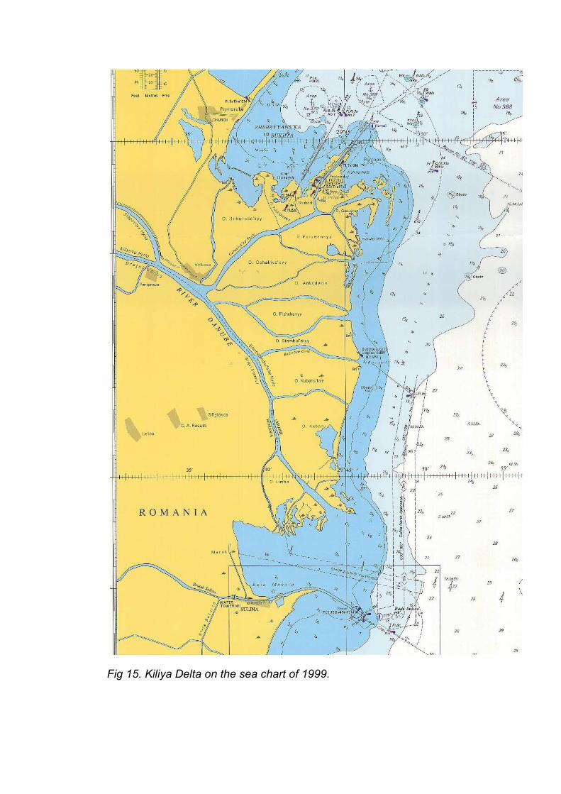
Fig 15. Kiliya Delta on the sea chart of 1999.
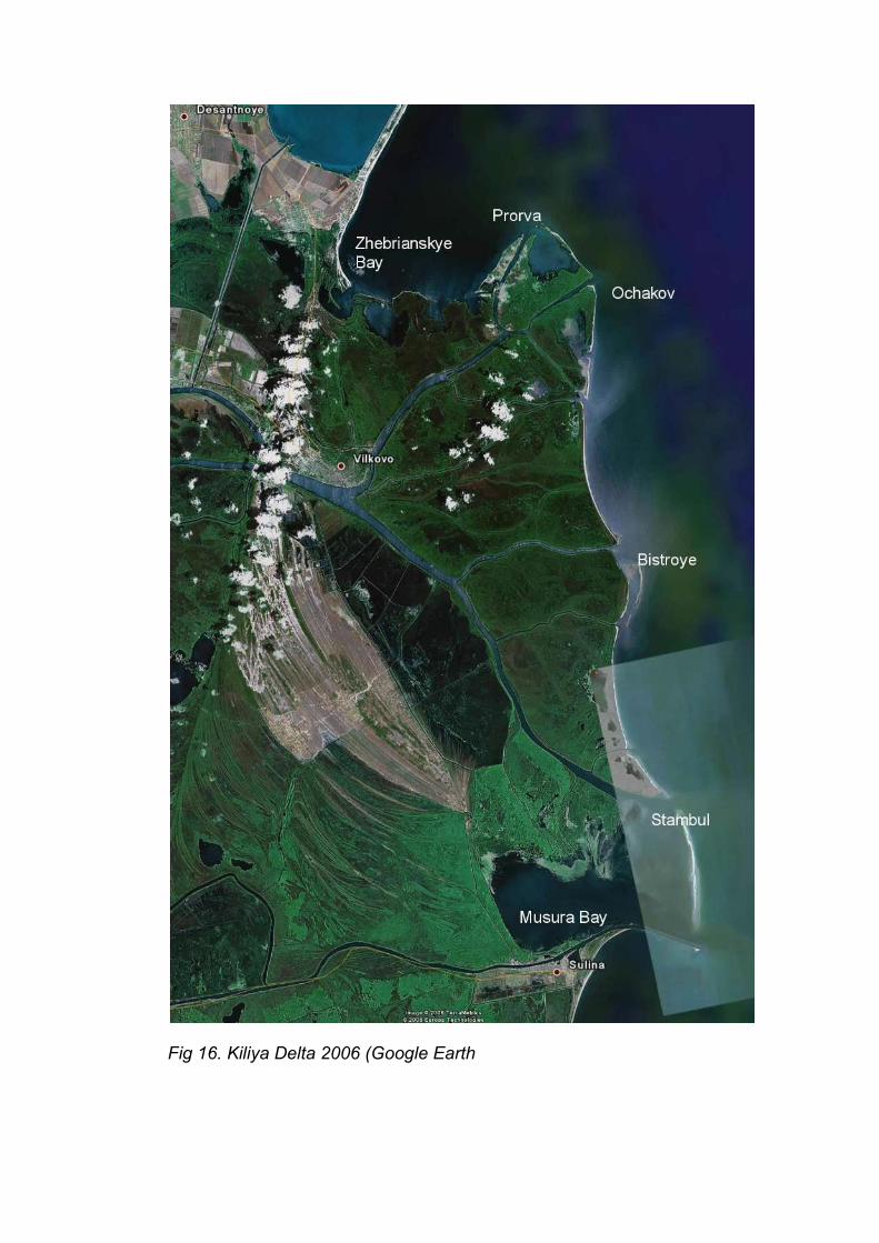
Fig 16. Kiliya Delta 2006 (Google Earth

3. Understanding the system: harbours and canals
3.1 Looking for an passage to the Danube
After the Crimean War as one of the stipulations of the Treaty of Paris in 1856, the first European Danube Commission was formed by representatives of Turkey, Austria, Prussia, Russia, Turkey, France and England. At that time, the Danube Delta was Turkish. In the Treaty of Paris, the Black Sea became an Open Sea, and the navigation on the Danube became free as well. Two Danube Commissions were installed, one for inland navigation, and one, the International Commission, to improve the connection between the Danube and the Black Sea. Chief engineer of the International Commission became the Englishman Sir Charles Hartley. The countries involved were: Austria, Russia, Turkey, Prussia, France and England. The interest of the great Empires of those days for the Danube was practical. The industrial revolution had caused an enormous demand for food, for grain especially. The western European countries couldn't feed their own populations. In the Black Sea area several harbours for grain export were built: Odessa, with the hinterland of the Ukrainian plains, Constanţa, with a rail connection to the Danube, and Sulina, with access to Braila. In the north, a connection middle Danube – Trieste played a similar role.One of the tasks of the Commission was to improve the navigability of the Danube. An important issue was the opening of one of the Danube riverbranches for vessels coming from the sea. In the national archives of the countries involved, the maps and reports of Sir Charles Hartley can be found. A series of maps,soundings and transects from the Nationalbibliothek in Berlin illustrates the actual situation as it was found by the Commission in 1856. (for orientation, see fig 2)
3.1.1. Sf. Gheorghe mouth 1856
The first rivermouth investigated is the St. Gheorgs-Mündung in the south. (figs 17 and 18) . The river divides itself in 2 branches, with a island and a sandbank in between. The southernmost branch has a narrow mainchannel of about 13 feet (= 3,96 m), surrounded by shallows of 4 – 1 feet (= 1.21 – 0,30 m). The northernmost branch at some places is only 7 feet (= 2,13 m) deep. Before the coast a large sandbank has formed of about 4 feet = 1.21m deep.In the transect, a dotted line of 16 feet (4.80 m) marks probably the needed depth for shipping. It is clear that although the Sf Gheorghe river itself is deep enough, the mouth is blocked by sandbanks. The coast at this point is growing seawards, and this is visible in the large sandbanks.

fig 18: Cross section Sf Gheorghe mouth 1856
3.1.2. Ochakov-mouth 1856
An even worse (for shipping) situation exists at the Ochakov-Mündung, in the northern part of the Kiliya Delta (figs 19 and 20).Here, the river extends into the sea for about 3 kilometers.At the inland side, the river is 32 feet = 9.7 m deep.At the seaside the river is about 12 feet= 3.65m deep, ending in an shallow area with a depth of 5 feet = 1.50 m.The river has been building up extensive riverbanks at both sides of the channel, protruding for about 3 km into the sea, with a depth of about 1 foot = 0,30 m.The Ochakov-mouth is growing seawards even stronger than the Sf. Gheorghe branch.
Fig 20: Ochakov-mouth, 1856, cross section
3.1.3. Sulina-mouth 1856
The situation at the Sulina branch was quite different. (figs 21 and 22) Here, the coast was eroding. Though the Sulina branch was bringing plenty of sediments as well, at an eroding coast these are taken away by the sea, and transported southward by the current. Therefore, the shallow area in the river is relatively deep (10 feet = 3.048 m), and short, about 600 m.

Fig 22. The relatively small sandbar in the Sulina rivermouth, 1856.
To get an idea of the situation at the coast here follows a citation about the situation at Sulina: “When the mouth was approached from seaward a great fleet of sailing ships could be seen anchored outside in the roadstead, and strewn all around were the wrecks of such vessels, some with their masts sticking up out of the water.In December 1855, during a terrific gale, 24 sailing ships and 60 lighters went ashore off the mouth and upwards of 300 persons perished; and in the whole of that year there were said to be 61 wrecks per thousand ships attempting to enter the river.” Biography of Hartley, p. 105
In fact ships with grain coming from the hinterland sometimes had to wait for months in order to get a chance to pass the sandbars.The International Danube Commission went into extensive discussions about the choice of the river mouth which had to be improved. The Kiliya branches, with the large shallows, many sandbanks and heavy sedimentation immediately were rejected. The engineer in chief, Mr. Hartley was in favour of Sf. Gheorghes'. There the coast was steep, and the sea current strong, thus assuring that any sediments were transported away from the harbour. He presented large plans and sections for both Sulina and Sf. Gheorghe at the meeting of the commission in 1856 in Braila. The Commissioners were strongly divided. At the end, no decision was made at all, and the choice was made by an old trick. The first step was to commission Mr. Hartley to do cheap and provisionally works at Sulina in 1857. As these works proved to be a success, the next step was to decide on more elaborate works at Sulina, in 1864.
3.2 The development of the Sulina Harbour 1778 – 2006
The jetties of Sulina harbour had and still have a large influence on the morphological development of the Danube Delta coast. In an area of ever moving sands the solid stone construction acts as a cornerstone. North of the jetties, the Kiliya Delta now has almost completely filled up the space towards the jetties.In 1778 (figs. 9 and 23) The mouth was simply the natural opening towards the sea. Two signposts used to be in place, but were blown away by a storm. The soundings mark the 2 deepest passages to the sea.

fig. 24 Sulina mouth, 1856. Preliminary investigations of the Danube Delta by Mr. Pratt and Mr. Wilkinson, HMS Medusa. British Library
In 1856, a British ship, H.M.S. Medina was sent to the Danube Delta to investigate the situation, to prepare plans and to take soundings.Hartley and his assistant engineers were already in Sulina as Wilkinson concluded the work.

(to be added / must be left out – not available from the national records. Kew))
fig 25. Design for the Jetties at Sulina, 1858, by Mr. Hartley, as presented to the International Danube Commission. National Archives, Kew, England
The function of jetties was the following.In a tideless sea, sandbanks form at the outlet of a river into the sea. As soon as the river reaches the sea, it widens, and looses its power to transport the sandy particles. According to the discharge of the river more or less deep canals are formed in between sandbanks of changing position and form.Jetties prolongate the river to a point behind the sandbars at the coast. In the narrow space between the jetties, the river maintains ist transport capacity. The sediment is brought to a place in deeper water, where it disappears in the depyhs, and is transported away by the current.This solution was quite new about 1858. People all over the world were experimenting: Oder, Vistula in the Baltics, the Rhone and Nile Delta's in the Mediterranean, and the Mississippi in the Gulf of Mexico.

(to be added – must be left out)
fig. 26. Design for the provisionary plan for Sulina Harbour, 1859. National Archives, Kew, England
As the Danube Commission could not make a choice between Sfantu Gheorghe mouth and Sulina Mouth, the decision was made to start inexpensive works at Sulina. These should last for a period of 5 years.The construction was finished in 1861, and was a huge success. The river maintained its depth at 6 meter without the need for dredging.In 1865 new money became available, and the decision was taken to build new and definite jetties at Sulina.

fig 27. The opening of Sulina Harbour with its low-budget jetties in 1861. The Illustrated London News, Oct. 1861. “ Shortly after ten o'clock the company quitted the dinner-table and adjourned to the neighbouring sands, where a brilliant display of fireworks terminated the fête.”
Fig.28. Sulina Harbour in 1918. The good old jetties are functioning well. To the south, downstream, considerable sedimentation takes place.(Karte der Donau von Ulm bis zur Mündung, 1918)

Fig 29. Sulina Harbour , British Sea Chart 1926.The area between The ever expanding Kiliya Delta in the North and the prolongated Sulina jetties becomes gradually filled up. On this map the sand front in the north is visible as a sudden transition in water 1-2 feet deep (30-60 cm) and water 18 feet deep (5.49 m).South of the jetties an eddy (countercurrent) brings sediments to the coast.
Fig 30. Sulina Harbour in 1944 (see fig 13)
In 1944 the second elongation of the piers (jetties) shows on the map. Both north and south of the jetties sedimentation increases.

Fig. 31, Sulina Harbour 1983 (see fig. 14) The sedimentation around the top of the jetties caused a need for a further extension into deep water.
Fig 32. Sulina harbour, 1986. Romanian map.
On the map of 1986 three important changes are visible.Near the town of Sulina, a new harbour has been built. The southern jetty is interrupted, probably an outlet for sediments
and high floods towards the south. Downstream of the jettie the oval eddy (countercurrent) brings sediment back to the north. A new pier, perpendicular to and at the end of the southernmost jetty, must prevent the sediments in the countercurrent to block the entrance of the harbour.
fig. 33. Sulina Harbour, 1999British Sea Chart.
The Sulina jetties, in the meantime 8 km long, have pushed away the Black Sea Current to the west. In the North, the Bay of Musura has become shallow completely.The situation between the Kiliya delta and the jetties is not adequately surveyed.

Fig 34. Satellite image of Sulina, Musura bay and the southernmost part of Kiliya Delta. 2006
On the satellite image (Google Earth, 2006) the actual situation is visible. From the Sea Chart 1999 (fig 33) we know that Musura Bay has become very shallow. In the eastern part of the area, a long sandy ridge has been formed, and is about to close off Musura Bay. The location of the sandbar has been influenced by an underwater dam. In the north, the Old Stambul Branch of the Kiliya Delta still brings considerable amounts of water and sediments to the area.It may be expected that this development will go on. Musura Bay will even more silt up. The sandy ridge will grow, and one or more outlets of the Stambul branch through the ridge will develop. The jetties of Sulina have had influence on the development of the coast from the beginning. In 1778, Sulina mouth was on an eroding coast. The small piers of 1861 caused increased sedimentation in the south. The stone walls of the jetties have been acting as a kind of fixed node. The piers have pushed the Black Sea current 8 km from the coast. It has to be expected that the easternmost opening of the two Sulina piers will become incorporated in the coastline. As the influx of sediments from the North continuous, probably new works to keep the Sulina entrance to the Danube open will be necessary. South of the piers, the counter current already changed the coast from a eroding to an expanding coast for a considerable length. In fact, just south of the jetties a new sandbank / ridge is in full evolution. (fig 34 A) It has to be investigated whether a sediment-water separation device could bring more sediments into the coastal area south of the Jetties. Musura bay has developed into a brackish lake, a quite rare and valuable environment in the Danube Delta (Grigoras, 2006)

Fig. 35. Currents and sediments at the end of the Sulina Jetties, 1999. (source: Romanescu, 1999)

Fig. 36. Sulina harbour, hydrofoils to Tulcea.

Fig 37. Sfantu Gheorghe, inundated coastal plain and dunes
3.3 The Development of the Sfantu Gheorghe mouth 1771-2006
Fig 38: The river mouths of Sulina (North) and Sfantu Gheorghe (south), 1771. (Source: University Library, Leiden NL)
The latter is marked by 2 signposts. An island in the middle indicates the shallow area just before the river mouth. In fact, two canals , north and south of the island, brong the waters and sediments of the Danube to the Black Sea.

Fig 39. 1856 Sf. Gheorghe(Source: Medina chart, Nationalbibliothek, Wien))
Before the mouth of the Sfantu Gheorghe branch a large sandbank is situated. The bar extends some kilometres to the south west.
South of the river mouth, an elongated island, separated from the mainland by a narrow water, can be recognised. The expansion of the coast south of the river mouth is followed by the formation of dunes north of the river mouth.Mark that in the north, near Sulina the coastline bends to the west (left).

Fig 40. 1856. Detailed map of the Sf. Gheorghe branch, made by the Medina-crew. (source: National Maritime Museum, London)
At the detailed map of the Sf. Gheorghe mouth, north of the river parallel ridges with dunes are indicated, to the west (left) of the Saraturile Grindul begins.

fig. 41. Coastline Sulina - Sf. Gheorghe in 1918.The map of 1918 shows to the south and south west of the river mouth a series of parallel ridges with low areas in between. These are the signs of a continuous expansion of the coast bij the formation of sandbanks and southward pointing islands south of the river mouth. In front of the river, such an island has just emerged from the shallow waters. To the north, a dune area is expanding as well (figs 37 and 40). (The map, in the Austrian National Library, is dated 1918 in the

cataloque. The actual situation represented may be as early as 1890 – before the large flood of 1897, that caused the Sacalin island to appear.)
fig. 42 Sulina – Sf. Gheorghe 1936.
At Sf.Gheorghes' mouth, the map of the Royal Navy of 1936-1956 shows clearly a further development of the island on the map of 1918. A long and narrow island from the middle of the river mouth to the south and south west: Sacalin island has been formed.
In the North, at Sulina, the new coastline, with a bend towards the east (right) shows that south of the Sulina jetties the coast is growing as well.

Fig. 43 Sulina – Sf. Gheorghe in 1986
The Romanian map of about 1986 beautifully shows much of the morphology of the SF. Gheorghe II delta: series of more or less parallel sandbars, with lower areas in between. South of the mouth, the bars consist of sediments brought by the river, and reworked and transported by the currents of the sea. Sacalin island has grown, and an island south of it has been formed.To the north of Sf. Gheorghe mouth, the seaward expansion has been followed by the formation of sandbars and dunes, expanding the Grindul Saratirule eastward.

Fig 44. Sfantu Gheorghe mouth, 2006. Google Earth.
On the Google-Earth satellite image The growth of the Sfantu Gheorghe mouth is apparent, with the Sacalin island in the south as the youngest addition. Accoding to a powerpoint presentation of the DDNI , Sacalin island is at the moment eroding. The cutting of the large meanders in the Sf Gheorghe branch in 1990 caused a larger flow of water and sediments to the sea. Probable a new sandbank is building up east of Sacalin island. (Grigoras 2006)
fig 45. Sacalin Island (left). In the semi-enclosed shallow water.The water is brackish, and .... is developing.

3.4 Riverworks
3.4.1. Sulina BranchAt the time of the works on Sulina harbour, the Sulina branch only got about 8 % of the water of the Danube. Soon the need for improving this branch made itself felt. Shallow areas had to be dredged. Bents had to be cut. Locally, gruoynes and dams were built. At the sharp Tulcea bent, a particularly nasty and dangerous rock had to be removed.And more water had to be sent to the Sulina branch. Therefore, at the two dividing points, works were carried out. This was the case at Chatal Izmail, the dividing point between the Kiliya Branch and the Tulcea Branch and at Chatal Sf. Gheorghe, where the Sulina Branch and the Sf. Gheorghe Branch split.These works were started in the 19th century already, and in fact, are still maintained. The dredged material from the Sulina was put at the shores, there forming a kind of dam, with interruptions.
(fig. 46, map with names mentioned in these paragraphs, to be added)
3.4.2. Sf. Gheorghe BranchAlthough favoured by chief engineer Hartley, in the end the Sf. Gheorghe branch was not chosen to be improved as a harbour. Although used for local traffic, the mouth remained natural. In 1990, several meanders were cut off, to improve the navigability, and to send more silt, sand and water to the sea.
3.4.3. Kiliya Branch Political situations in the last 150 years changed often, and the Kiliya branch at several occasions became to borderline between different powers: Turkey, Russia, (former) Moldova, the Sovjet Union, Romania, and, at this moment, Ukraine, Romania and Moldova.At the Kiliya branch, several harbours are situated: Kiliya, Izmail and Reni in the Ukraine, Kiliya Vecche in Romania. Moldova wants to build its own harbour, directly west of Reni. In the second half of the 20th century, the Soviet Union had built a new passage from the Black Sea to the Danube in the north of the Kiliya-Delta, in the Ochakov-Prorva branches. Here a harbour Ust-Dunaisk developed. After the collapse of the Union, maintenance was stopped, and due to heavy sedimentation, the harbour became almost useless.At this moment, the Ukraine looks for a connection between the Black Sea and the Danube on its own teritory. Much attention and discussion has been given to the plans to open up Bistroye Branch, in the middle of the Kiliya Delta.At this moment, rehabilitation of the Prorva Branch seems to be the solution in favor.In the next background paper this discussion, and possible solutions will be looked after in more detail.
The works at Chatal Izmail, to provide the Sulina Branch with more water, logically caused less water to flow through the Kiliya Branch. This could be one of the reasons that the Kiliya Delta slowed doen its rapid expansion eastward about 1940, and is changing from a river-dominated to a sea dominated system. (fig 13)
The building of dykes at the Ukrainian side, and of large polders on the Romanian

side have had large influence on the regime of the Kiliya Branch as well. This will be discussed later.
4. Islands in the Delta
In the figures 3 - 5 the long term development of the seaside of the Danube Delta has been described: an initial sandy ridge dived the delta in 2 halves. East of the sandy ridge, a series of sub-delta's developed over the long period of 12.000 years.In this long period, water levels of the Black Sea changed considerably, and the level of deposits of these deltas are quite different.At this moment, large parts of these sub delta's are, in fact, drowned and covered by lakes and marshlands. They will be discussed in the background paper on the inner delta.Three features of very old formations that are part of these former deltas demand our attention: Karaorman and Letea Forest in Romania, and Zhebrianskye Ridge in the Ukraine.These sandy areas are laying as islands in the midst of the huge marshlands.
At the actual coast, new dunes are formed at the coast of the Kiliya delta, south of Sulina and near Sf. Gheorghe. (fig. 48)Together with the network of riverine levees along the numerous riverbranches these old a new dunes form the only dry places in the delta.
Fig. 47. The Village of Letea, one of the three villages in Letea Forest.

Fig. 48. Geomorphological map of the Danube Delta, detail.(DDNI/Riza)
4.1 Zhebrianskye ridge
Zhebrianskye ridge consists of a series of dunes, mostly plated with pine trees. In the east, it has a gentle transition to the northern part of the Kiliya Delta. In the west, it borders the former, now embanked, floodplain of the Danube. The main road from Vilkovo to the north, crosses the ridge. (fig 52)
4.2 Letea Forest and Caraorman
Letea Forest is part of the old Sulina Delta (fig. 5 and 48)
The basic formation consists of a series of sandy ridges with lower areas in between, originally a sequence of sandbanks like Sacalin island. The groundwater is fresh. Due to the steppe climate, evaporation exceeds precipitation. The groundwater below the ridges rises by capillary forces to the surface, and evaporates. The salts in the water are concentrated in the upper layer of the soil. Hence on the ridges a salt
tolerant vegetation is found, and no trees. (fig. 49) The lower areas in between, occasionally are flooded. The salt is washed away, and a completely different vegetation develops: a rich oak forest, with many species of trees (lime, ash, elm) and liana's, and a rich undergrowth. (fig 50)

Fig. 49. Letea Forest: meadow on the salty ridges, forest on the lower parts. A herd of rewilded horses roams the area. Foto Geert Overmars
Fig 50. Fresh water hole in the lower part of Letea Forest.


Fig. 51. Trees and shrubs on freshwater patches in a salty environment.
Foto Geert Overmars
In some parts of Letea Forest, the sand is blown by the wind into dunes. These dunes are too high for capillary forces to carry the water to the surface to evaporate there. Hence, salinisation only takes place at the lower sandbars, not on the much higher dunes. On the contrary, these dunes collect the rainwater that falls, and store the water inside. At some places, the freswater from the high dunes flow into the surrounding saltish sandbars, thus forming small patches of salt free land. There immediately the forest starts to grow in small patches, trees or some shrubs. (fig 51)

fig. 52. Zhebrianskye Ridge, planted with pine trees.
Fig. 53, Letea Forest, 1778.The map of 1778 shows, that in that time the sandy island in the east bordered to the sea. In the meantime, this coastal area is completely silted up with the Kiliya delta.On the map is written: “Stellen vur die Herden”, “Area for the herds”. Then, as now, the area is used for grazing. Cattle and horses for sure, and occasionally perhaps sheep as well.

fig 54. Caraorman, “ Der Wald Kara Urman” 1778.
The same applies to Caraorman, were the map indicates : “ Alhir halten die Inwohner diser Gegend ihre Heerden” “ here the people of this area are keeping their herds” .
Fig. 55. Letea Forest in 1918.
On the 1918 map, the wooded area is shown in greater detail. At this moment, a part of Letea is in fact overgrazed by cattle of the villagers. The northern part, however, has been turned into a “strictly protected area” by the delta authorities. Here the forest has been preserved in a very natural
state.Due to low prices for horses, the villagers some decennia ago left part of their horses alone in that part of the forest. The horses turned into a wild state, and quickly formed natural herds. (see document on natural grazing). <(fig.49)

Fig 56. Caraorman in 1918.
For Caraorman, the same principles apply. There is, however far less woodland preserved.
4.3Sf. Gheorghe dunes and Grindul Saratirule
North of the Sf. Gheorghe mouth, a new complex of dunes is forming. (fig 48). It follows the same pattern as elswhere: sandy ridges interchanged with lower plaines. (fig ..)
The area is in use as a common grazing area for the horses and cows of the villagers of Sf. Gheorghe. (fig 57)
fig 57. Dunes at Sf. Gheorghe, common grazing area.Foto Geert Overmars

fig 58.Dune area at Bistroye mouth.
Since the eastern side of the Kiliya Delta changed its mode of expansion to the building-up of sandbars parallel to the coast, about 1940, along this part of the coast dunes are forming as well.In the dunes a group of cattle has been left alone about 40 years ago. The animals survive in the wild, and are adapted to their environment.

5. Growing with the seaThe combined effect of a (tectonic) sinking land and a rising sea could amount to up to 1 meter for the next century. A living delta, that means a delta with its hydrodynamical processes in working order, has the best chances to survive. The delta will change continuously, it will grow in places, erode in other places. The most important things are, that the river must continue to bring ample sediments, and that these sediments are able to reach the right places.
5.1 Beaches and dunes.
As we have seen, in most places the coastline of the Danube Delta is still advancing, although this process, especially in the Kiliya Delta, has slowed down considerably during the last 50 years. (see doc about the inner delta). Only at a limited distance between Sulina and Sf. Gheorghe the coast is eroding and retreating.If enough sediments are available a dynamic coast is perfectly able to correct itself accordingly. The current, the wind and the waves will constantly rework the beaches and outer dunes of the Delta. They will move, and grow, and adapt themselves to the new levels.If there are not enough sediments available, the coast will start to erode, and sand will be lost to the depth of the sea, as happened before with large parts of the old Sulina delta.
The natural system
In the natural situation, a shallow sandbar closes of all the river mouths of the delta. This is the very area where materials from the river are given to the sea. At the river side, it causes the river to look for more and other openings to the sea. It causes flooding in times of high river discharge, and these floods deposit sediments on the riverbanks and into the reed beds and lakes behind them. At the seaside, silt and sand are separated, and the sea uses the sand to build and reinforce the coast.
The effects of the Sulina jetties
Opening the sandbar, as happened in 1858 at Sulina, will result in loss of sediments. The very idea of the Sulina jetties is, to maintain as long as possible the transporting powers of the currents of the river . Only at the end of the jetties, in relative deep waters, the sediments are allowed to sink to the depth of the sea.That happened in Sulina.
Opening a river mouth in this way in the Kiliya Delta is of even greater impact on the natural system. Here, as in Sulina, sediments would find a free exit to the sea, being lost for the build up of the beach and the dunes. Less sediments will during floods be forced over the riverbanks in the reed beds, so these will stop to grow.This 19th-century technique of opening river arms in tideless seas is used in many

famous deltas, and resulted often in the destruction of the most important processes. Both the Rhone and the Mississippi deltas were, as the Kiliya-delta, multi-branched deltas. In order to get the desired effect between the jetties, as much water had to be directed towards this one opening. In the cases mentioned, all other outlets to the sea were closed by dams. This completely ruined the natural sedimentation processes in these deltas.So opening the Bistroye-mouth has not only far reaching effects on the coastal development and the ability to grow with the sea, as we have seen at Sulina. Moreover, as one effect tends to trigger the next one, the need for more and more technocratic measures in the delta only will increase.
In an ever changing environment as an expanding and retreating sandy coast, solid constructions like jetties have a large effect on the morphology. Almost all sediments from the Kiliya branches are trapped north of the Sulina jetties. The coastline north of the jetties has moved about 8 kilometers to the east. South of the jetties, there is some sedimentation in the countercurrent or eddy, but in fact further south there is sand hunger and an eroding coast up to the point where Sf. Gheorghes mouth brings new sediments.In fact, once the area directly north of the jetties is filled up, the stream of sediments will directed towards the deep seas, where it is lost for the coast. This will happen in the near future.
As for the situation at Sulina, modern techniques make it possible to separate sediments and water. If the sediments of the Sulina branch could be brought into the coastal current that goes down to Sf. Gheorghe, this would partly restore the natural conditions.The northern coastline approaches the end of the Sulina jetties. Probably new works are needed to protect a free entrance for ships. It should be investigated whether there are possibilities to let pass the sediments from the Kiliya branch to the current south of the jetties towards the coast.
Bistroye and a new harbour for the Ukraine
The plans for opening the Bistroye mouth in the Kiliya-harbour seem to be abandoned. They will, however, sooner or later return in other plans and projects, as they popped up every now and then in the last 150 years.The argumentation against this project was to a large extend based on the damage to the ecosystem in the area around the Bistroye arm. Of course these arguments are right in their selves. But the long lasting morphological effects are of far bigger influence to the delta and to the ecosystem.So the morphological argumentation should be brought into the discussion.
If the Ukraine wants a passage from the Black Sea to the Danube on its own territory, probably a passage from Zhebriansky Bay in front of liman Sasyk through a canal towars the Danube near Leski is the best, but expensive solution.It will be investigated in another background document, as was proposed in the 19th century already.
In fact, any solution for shipping outside the delta is of great help for the delta.

Constanţa with its harbour and canal is a good example.
Theoretically, for the delta the closing of Sulina, with the removal of parts of the jetties to restore the coastal current, would be the best solution. A new Zhebriansky-Leski canal would probably do far less damage. This possibility, however, is regarded as impossible in the given situation.
Other solid structures in the dunes
In other to adapt itself to changing circumstances, a sandy coast should have the freedom to develop. Any solid construction on the beach will find itself after some years back kilometres from the coastline land inward, or it will be destroyed by the sea. If beach tourism develops, no fixed constructions as hotels near to the dynamic beach should be constructed.
Recommendations:
− no opening of the Bistroye mouth − propagation of the hydromorphological argumentation against Bistroye, in
addition to the ecological arguments− study for an alternative harbour for the Ukraine outside the delta proper− study for possibilities to restore the flow of sediments to the coast south of
Sulina.− no fixed constructions in the dynamic environment of the dunes.
5.2Behind the coastline: Kiliya delta
Continuous sedimentationBehind the actual coastline of the Kiliya Delta a very young landscape of river arms, with small, low and narrow riverbanks around large areas of reed beds and lakes is found. Without a natural process of vertical growth this landscape would disappear in the waves of the rising sea.So, here sedimentation is the solution as well. Many river arms transport sand and silt to every corner of the area. As long as the many riverbranches carry sediments to the delta, the riverbanks will continue to grow, and the reed beds will continue to filter the silt out of the brown waters of the Danube.
No dykesIn order to function properly, areas that has to silt up in time, must be allowed to become flooded. Dykes do the contrary. Dykes prevent areas to be flooded, and thus they prevent sedimentation, and the ability to grow with the sea. Dykes give a false feeling of safety, and they invite to invest in the embanked area. Dykes have a nasty habit of breaking however solid they appear. Dykes become dangerous for people and animals, and damaging for goods. In the end, embanking an area is a one-way alley. The more the sea rises, the more investments are needed, and the more dangerous the dykes become.Dykes are originally meant for protection of low-investment goods, like a crop of

cereals. Many years they protect the crop, and the one year they don't there is a certain loss. But high investment commodities, like oil refineries and chemical plants shouldn't be built behind dykes. A good example is Rotterdam harbour, as it expanded to one of the largest harbours in the world during the last 50 years. All industrial estates have been built on large mounds, out of reach of the waters. Cynically, housing estates in Rotterdam have been built in polders of up to 6 meters below sea level.Dykes are especially dangerous as the land behind the embankment lies deep. A break in a dyke then causes a sudden en deep flood in little time.
In a steppe climate, dykes do have an additional drawback. The groundwater is near the surface of the embanked area, so capillary forces will send water to the surface, where it evaporates in summer, causing a layer of salt to form in the upper layer. In the natural situation such concentrations of salt disappear during the next flood. In the embanked situation, the soil becomes increasingly saltish.
For the natural vertical growth of the delta, dykes should be avoided.
Mounds
The easiest way to escape a flood is to step on a piece of land that is a bit higher than the surrounding area. And if this is not high enough, it is an easy step to heighten a small area a little bit. A mound is save. One sees the water approaching, it doesn't come all in a sudden. Even when the mound is not high enough, the top is the safest en less inundated place around. If the waters fall, a mound is the first to reappear.Mounds have almost no impact on the sedimentation process.
So, if a city like Sulina, or the few villages in the delta want to keep up with the rising of the sea, it should start a slow process of transition to living on a mound. There is no need for a sudden transition, because the level of the sea rises slowly, and there is ample time.If somewhere in the delta a permanent structure is needed, it should be built on a small and relatively low mound.
5.3 Behind the coastline: the drowned delta's and their islands.
West of the Sulina ans Sf.Gheorghe deltas lie the vast areas of reedbeds, lakes and marshes on top of the drowned parts of the old Sf.Gheorghe I, Sf.Gheorghe II and Sulina deltas. Here, no multitude of river arms bring sediments for growth. On the contrary, during floods the water made a long way from the river through filtering reed beds, and is clear or even peaty. Quite other processes like floating reed beds and peat formation are active in this environment.The dynamics of this environment will be discussed in a background document on the inner delta.
The three large islands in the area, Zhebriansky ridge, Letea Forest and Caraorman, do not have a natural process of vertical growth, apart from some local windblown dunes. So, probably, parts of them will gradually disappear in the surrounding swamps, and dry parts will become wetter.

[ Is a map with the heights of the islands available?]
Recommendations:
− no opening of Bistroye mouth− active network of sediment carrying river branches in the Kiliya Delta− no dykes− if needed: mounds− more detailed study on the effects on the three old islands.
6. Projects and Model sites
6.1 Opposition against Bistroye Canal
Although the opposition against opening Bistroye mouth has been successful so far, the argumentation against it from the morphological point of view has not been strong. So an awareness raising campaign directed towards all organisations involved should be undertaken.
6.2 Study for an alternative Ukranian harbour
The best solution for the passage of ships from the Black Sea to the Danube is to go on using the two existing passages: Constanţa and Sulina. A new passage at Bistroye is detrimental voor the development of the coast, and will cost continuously large amounts of money for dredging.
If the Ukraine wants to have a passage on its own territory another solution should be proposed.In order to do so, experts from several dutch consultancies, and from the harbours of Rotterdam and Amsterdam, will make a study for such an alternative.As a preparation for this alternative, another background paper has been prepared.
6.2Study on Sulina harbour.
From this morphological study it becomes clear that within a relatively short period of time, the southern point of the Kiliya Delta, will reach the easternmost end of Sulina Jetties.A new idea about the future of Sulina harbour is needed. From the morphological point of view, the question is how the sediments from both the Sulina branch and from the Kiliya delta could be made available for the development of the coast south of the Sulina jetties. The same group of experts could work out ideas about this subject.

6.3 Dykes or mounds
In an economically developing delta, investments are made. And investments have to be protected against flooding. Dykes, traditionally are the way to do so.Dykes, however, interrupt the morphological processes that are needed for the delta to grow with the rising level of the sea.Ecological restoration of embanked areas should include removing of most of the dykes.An awareness raising campaign should be started, directed to all who − develop plans to build new dykes− develop ecological restoration plans for embanked areas.In the Seaside part of the Delta, villages and towns will start to modernise and grow. Together with other goals (restoration, ecotourism, grazing) a model site for building on a mound could be a good example for the discussion.
The southern part of Popina, the silted up area between Letea and the Stambul branch, is restored by making breaches in the dykes. This is a good first phase. In a model site, the removal of most of the dyke can set a good example as illustration of the morphological argumentation.
6.4other model sites or projects
This background paper is about the morphological aspects of the seaside of the delta.In combination with other goals, as restoration, awareness raising, field schools, ecotourism, grazing, these morphological aspects will return in other proposals.To remedy the loss of sediments will also be diiscussed in other background documents.

7. literature:
Drost, H.J., D. Bos & M. Tudor (2002) Research for ecological restoration in the Dunavat/Dranov region, Danube Delta. (1.6 Mb)
Gatescu, P. (1991) Les Transformations morpho-hydrondynamiques et l'équilibre écologique dans le Delta du Danube. Revue Roumaine de G éographie, 35: 37-43
Gatescu, P. (1993): The Danube Delta, geographical Characteristics and Ecological Recivery. Geo-Journal 29, 1:57-67 Kluwer Academic Publishers.
Gatescu, P & B.Driga (1989): Der Wasserumlauf im Donau Delta - ökologische und wirtschaftliche Bedeutung. Revue Roumaine de Géologie, Géophysique et Géographie, Ser. Géographie, 33:37-41
Gastescu, P. & Oltean (1997) Ecosystems of the Romanian Danube Delta Biosphere Reserve. (360 kb)
Gastescu, P., M. Oltean, I. Nichersu & A. Constantinescu (1998) Ecosystems map of the Danube Delta Biosphere Reserve. (4.0 Mb)
Grigoras, Ion, (2006) , Use of satellite images for Morphological Analyses in danube Delta biosphere Reserve. Powerpoint Presentation DDNI.
Hanganu, J., D. Dubyna, E. Zhmud, I. Grigoras, U. Menke, H. Drost, N. Stefan & I. Sarbu (2002) Vegetation of the Biosphere Reserve Danube Delta. (1.7 Mb)
Hanganu, J., D. Dubyna, E. Zhmud, I. Grigoras, U. Menke, H. Drost, N. Stefan & I. Sarbu (2002) Transboundary vegetation map of the Biosphere Reserve Danube Delta. (6.2 Mb)
Hartley, C.W.S. (1989). A Biography of Sir Charles Hartley, Civil Engineer (1825-1915). The father of the Danube. 2 vols. Studies in British History, Volume 9.
Munteanu, I. (1996) Soils of the Romanian Danube Delta Biosphere Reserve. (17.0 Mb)
Munteanu, I. & G. Curelariu (1995) Soil map of the Romanian Danube Delta Biosphere Reserve. (8.3 Mb)
Munteanu, I. & G. Curelariu (1996) Thematic map of the Danube Delta 1: head

deposits. (3.7 Mb)
Munteanu, I. & G. Curelariu (1996) Thematic map of the Danube Delta 2: top soil texture. (3.4 Mb)
Munteanu. I. & G. Curelariu (1996) Thematic map of the Danube Delta 3: soil salinity. (3.2 Mb)
Munteanu, I. & G. Curelariu (1996) Thematic map of the Danube Delta 4: drainage and inundability . (3.4 Mb)
Oosterberg W., Staras M., Bogdan L., Buijse A.D., Constantinescu A., Coops H., Hanganu J., Ibelings B.W., Menting G.A.M., Navodaru I. & Torok L. (2000) Ecological gradients in The Danube Delta lakes : present state and man-induced changes. RIZA report 2000.015 (21.9 Mb)
Panin, H. 1998, Danube Delta: geology, sedimentology, evolution. Field trip of ASF, Association des sedimentlogistes francais.
Panin, prof. Dr., Powerpoint Presentation and verbal communication 2006.
Romanescu, Gheorghe, 1996. Delta Dunarii, Studiu morfohidrografic. Iaşi.
Romanescu, Gh., 1995. Delta Dunarii. Iaşi.
Romanescu, Gheorghe, 2002. Medii de sedimentare terestre şi acvatice. Delta şi estuare.
Romanescu, Gheorghe, 1999. The Danube Delta – Some Hydromorphodynamic Aspects. Suceava.
Platteeuw, M., J. Botond Kiss, M.Y. Zhmud & N. Sadoul (2004) Colonial waterbirds and their habitat use in the Danube delta. RIZA report 2004.002. (7.4 Mb)
List of Maps
(to be added)