VIRGINIA'S COAL AGES
37
VIRGINIA DIVISION OF MINERAL RESOURCES PUBLICATION 149 VIRGINIA'S COAL AGES S. O. BIRD COMMONWEALTH OF' VIRGINIA DEPARTMENT OF MINES, MINERALS AND ENERGY DIVISION OF MINERAL RESOURCES Stanley S. Johnson, State Geologist CHARLOTTESVILLE, VIRGINIA 1997
-
Upload
nguyenxuyen -
Category
Documents
-
view
228 -
download
1
Transcript of VIRGINIA'S COAL AGES
VIRGINIA DIVISION OF MINERAL RESOURCESPUBLICATION 149
VIRGINIA'S COAL AGESS. O. BIRD
COMMONWEALTH OF' VIRGINIADEPARTMENT OF MINES, MINERALS AND ENERGY
DIVISION OF MINERAL RESOURCESStanley S. Johnson, State Geologist
CHARLOTTESVILLE, VIRGINIA1997

DEPARTMENT OF MINES. MINERALS AND ENERGYRICHMOND, VIRGINIAO.Gene Dishner, Director
DIVISION OF MINERAL RESOURCESCHARLOTTESVILLE, VIRGINIA
Slanley S. Johnson, State Geologist and Division Director80+963-2308
STAIIFKay T. Hasenauer, Executive Secretary
80+963-23W
ECONOMIC MINERALS AND ENERGY SECTION SPATIAL DATA AND EASTERN GEOLOGY SECTIONPalmer C. Sweet, Section Head, 804-963-2313 lan J. Duncan, Section Head, 804-963-23V1Jack E. Nolde, Geologist Senior, 804-963-2318 C. R. Berquist, Jr., Geologist Senior, 757-221-2448Roy S. Sites, Geologist Senior, 8M-963-2320 Elizabeth V. M. Campbell, Geologist Senio,r, 8M-963-2311Michael L. Upchurch, Geologist Senior, 8M-963-2322 Nick H. Evans, Geologist Senior, 804-963-2317
V/illiam S. Henika, Geologist Senior, 540-231-4298SOUTHIVEST MINERALS AND GEOLOGY SECTION Karen K. Hostettler, Geologist Senior, 8M-963-2312Alfred R. Taylor, Section Head,540-676-5577 David B. Spears, Geologist Senior, 8M-963-2319James A. Lovett, Geologist Seniot 540-67 6-5577William W. Whitlock, Geologist Senior, 5&676-5577 PUBLICATIONS AND WESTERN GEOLOGY SECTION
Eugene K. Rader, Section Head and Editor, 8M-963-23rcSALES AND SIIPPORT SECTION David A. Hubbard, Jr., Geologist Senior, 8M-963-2314Delores J. Green, Office Manager, 8M-963-2315 John D. Marr, Jr., Geologist Senior, 8M-963-23A6Antionet&e Arsic, Office Services Specialist, 8M-963-2270 Vernon N. Morris, Cartographic Drafter Assist., 8M-963-2324Blwin W. Marshall, Geologist Technician, 8M-963-2316 Gerald P. Wilkes, Geologist Senior, 8M-963-2323Paige S. Roach, Store Operations Supervisor, 8M-963-2305
Sates: 804-293-5121 Information: E04-963-23ffi
Portions of this publication may be quoted or copied if credit is given to the author,the Division of Mineral Resources, and the Virginia Department of Mines, Minerals and Energy.
VIRGINIA DIVISION OF MINERAL RESOURCESPUBLICATION 149
VIRGII\IA'S COAL AGESS. O. BIRD
COMMONWEALTH OF VIRGINIADEPARTMENT OF MINES, MINERALS AND ENERGY
DIVISION OF MINERAL RESOURCESStanley S. Johnson, State Geologist
CHARLOTTES VILLE, VIRGINIAt997
CONTENTS
Page
ILLUSTRATIONSPLATE Page
i: ["if*:*iti#3*:Jffi:"ilili:i.:*::::::::::::::::::::::::::::::::::::::::::::::::::::::::::::::::::::::::::::::: :r?l
5. Restoration scene of a
FIGURE
l. Physiographic provinces of Virginia and areas mined for coal.............. ............ 22. Generalized stratigraphic section of the southwest Virginia coalfield ............... 33. U.S. consumption of oil, natural gas, and coal 1970-1994 ................ ................ 34. Charred remains of the dense forest in the Great Dismal Swamp......... ............. 4
6. Confguration of base of Dismal7. Triassic, Carboniferous, and Upper Devonian rocks of parts of Virginia. ......... 98. Generalized geologic map of part of southwestern Virginia... ......................... l09. General position of seas and lands in eastern U.S. during Carboniferous times ................... 11
10. Land and sea of part of Appalachian basin during Early Mississippian time ....................... 1211. Cross-bedded quaftz sandstone of the Early Pennsylvanian-age Lee Formation at Cumberland Gap ....-. 1412. Watergapof theNewRivernearNarrows,Virginia .................. 14
15. A view westward
TABLESl.2.

VIRGINIA'S COAL AGES
S. O. BIRD
ABSTRACT
Virginia's coals lie in three distinct geologic settings: theyoungest coal is in Mesozoic-age basins of the Piedmontprovince (chiefly in the Richmond basin), in Early Mississip-pian-age rocks of the Valley and Ridge province, and in mainlyPennsylvanian-age rocks of the Appalachian Plateaus prov-ince. The history of production follows this classification, butdevelopment was related to population and geography ratherthan to geology. Coal was first mined in the Richmond basinin the mid-1700s, in the Valley and Ridge province in themiddle I 800s to the early 1 900s, and from the I 880s until todayin the plateaus province.
Coal forms from peat such as is present in the GreatDismal Swamp (southeastern Virginia and northeastern NorthCarolina), which is a modern model of earlier coal swamps.However, the plants and animals of today are much changedfrom those that lived in the peat swamps of the "Coal Ages."
INTRODUCTION
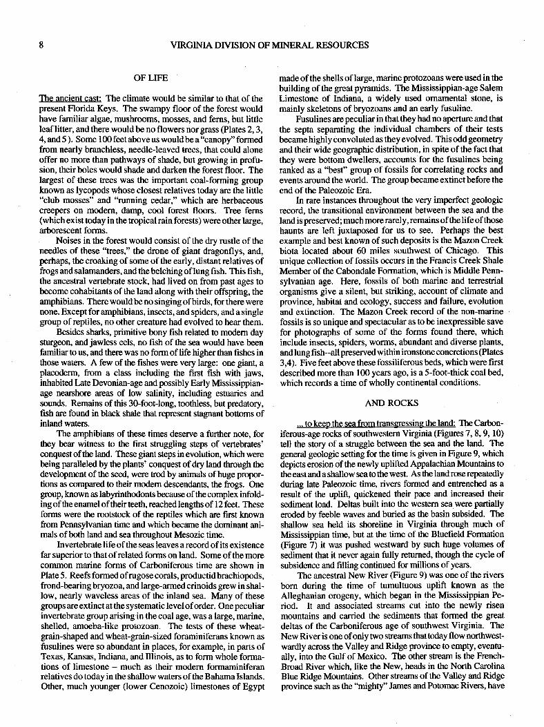
Coal was the fuel of the industrial revolution and it is the fuelfor the forseeable future. Long after oil and gas supplies havebeen exhausted, coal resources will remain. New uses areconstantly being found for coal and old ones are being rediscov-ered or renewed. Some coals are largely free of sulfur andtherefore can be burned without giving off SO*. Fluidized bedexperiments by the U.S. Department of Energy Show that sulfur-beming coals can bebumed in thepresenceof limestone to greatlyreduce SO" emissions. Coal can also be used as a "liquid" fuelwhen mixed with water and detergents. Some of the research onthis has been canied out by Atlantic Research and by United CoalCompany (Bird, 1985). Further research at United Coal facilitiesin Bristol, Virginia have been toward producing coke, dieselfuels, and high-grade gasolines from coal in series of distillationprocesses. Coal produces some 50 percent of the electricitygenerated in Virginia and it is also used in cogeneration plantswhere heat and electricity are produced from steam generated byburning coal. Coal contains methane, or natural gas. In placesthis gas is ahazard tomining, but the gas content can also be usefulas it is drawn off by drilling the coal to release the methane beforeor during mining. Operations producing gas from coal have beencarried out for years in the Black Warrior basin of northcentralAlabama and by Island Creek Coal Company and EquitableResources Energy Company in southwestern Virginia to degascoal beds in Buchanan and Dickenson Counties.
Coke made from coal is required to make steel from iron.Coal by-products, such as tar and pitch together with derived gas,find many uses in the chemical, fertilizer, plastic, insecticide, anddye industries.
Great quantities of coal from Virginia, West Virginia, andKentucky are loaded for export onto supersized ships at the portterminals ofNewport News, which include the Dominion Termi-nal completed in 1984. Virginia ranked eighth in annual coalproduction in the U.S. in 1995.
GENERAL GEOLOGY OF VIRGINIA'S COALS
KING COAL
The youngest coal deposits in Virginia and the first ones tobe mined in the United States are from an area near Richmond,where several bituminous coal beds occur in Mesozoic-age rocksoccupying a faulGformed basin @gure 1, Plate l). These coalswere first mined commercially in I 748, and were mined continu-ously until 1904 when production ceased. Coal from this meawas being shipped fromHampton, Virginiato the NewYorkCityarea as eady as 1758. Virginia coal was an important firel sourcealong the Atlantic seabomd until about 1820, when extensivecanal construction made Pennsylvania anthracite available toareas formerly supplied by Virginia. The Richmond coalfieldbecame a major fuel source during the Civil War, but pmductiondeclined after the war, and was cut in half the year that the firstshipments of coal left Tazewell County, in southwestern Vt-ginia, by rail in I 883. Production of Mesozoic-age coal declinedsharply thereafter.
Mesozoic-age coal was extacted using rnanual labor inunderground mines from five separate mining districts in theRichmond coalfield. The thickest coal was over 5Gfeet thick. buttypically the coals mined were from 5 to l0 feet thick. Over thelife of the field, over 8 million tons of coal was removed. TheRichmond coalfield is currently thought of as a viable coal-bedmethane resource. Resource estimates have not been made forcoal of the same age in the Farmville basin to the west, where onefive-foot thick coal bed was mined for local use in the mid- 1800s.
Coal was produced commercially from the Valley coalfi elds,(Figurc 1) lying in the area from Botetourt County to SmythCounty as early as I 860 and as late as I 993 . The coal that fueledthe frigate Merrimac in its historic encounter with the Monitorwas from the Merrimac coal bed in Montgomery County. TheMerrimac bed with othercoal beds in Montgomery andPulaskiCounties furnished the great bulk of Valley coal production.Mining access to semianthracite and bituminous coals of theValley is commonly severely limited, because in places thestratigraphic units containing them are intensely deformed. Thecoals can be mined along strike in suitable places, but in the dipdirection they plunge far below the surface, commonly over shortlateral distances. The coal was mined in shafts in these areas. Atplaces the beds are displaced by faults.
The 1996 value of coal produced in Virginia was $974.36-million (Sweet and Nolde, In Press). All the coal mined inVirginia today is bituminous rank from the plateaus province,which includes all orparts of Buchanan, Dickenson, ke, Russell,Scott, Tazewell, and Wise Counties. Of the counties, Buchananis the leading producer and Wise is second. Some 95 percent ofthe state's coal resources are in the plateaus province, wheremining has been continuous since the 1880s, the time whenrailroads wereextended intotheregion inordertomarketthecoal.Demonstratedreserves forVirginiawereabout2.32-billion shorttons in January, 1995.
Virginia's plateaus-province coal is mostly high- to low-volatile A. bituminous coal. Some of this coal is used as coke

VIRGINIA DIVISION OF MINERAL RESOI.]RCES
COAL FIELDS
SOUTHWEST
RICHMOND
VALLEY
1€FJl3i
\CAFFOLL","*\ "e*at ,/
VALLEY AND RTDGE PIEDMONT (TRIASSIC BAsll'lstl )COASTAL PLAIN
Figure 1. Physiographic provinces of Virginia and areas mined for coal. The fall line is at the PiedmonVCoastal Plain bundary.Virginia was in the southern hemisphere in Late Mississippian time according to paleomagnetic data. No coal is currently beingmined in the Valley fields or in the Richmond basin.
li"^"'ff"it);,*j ;t #*iffi
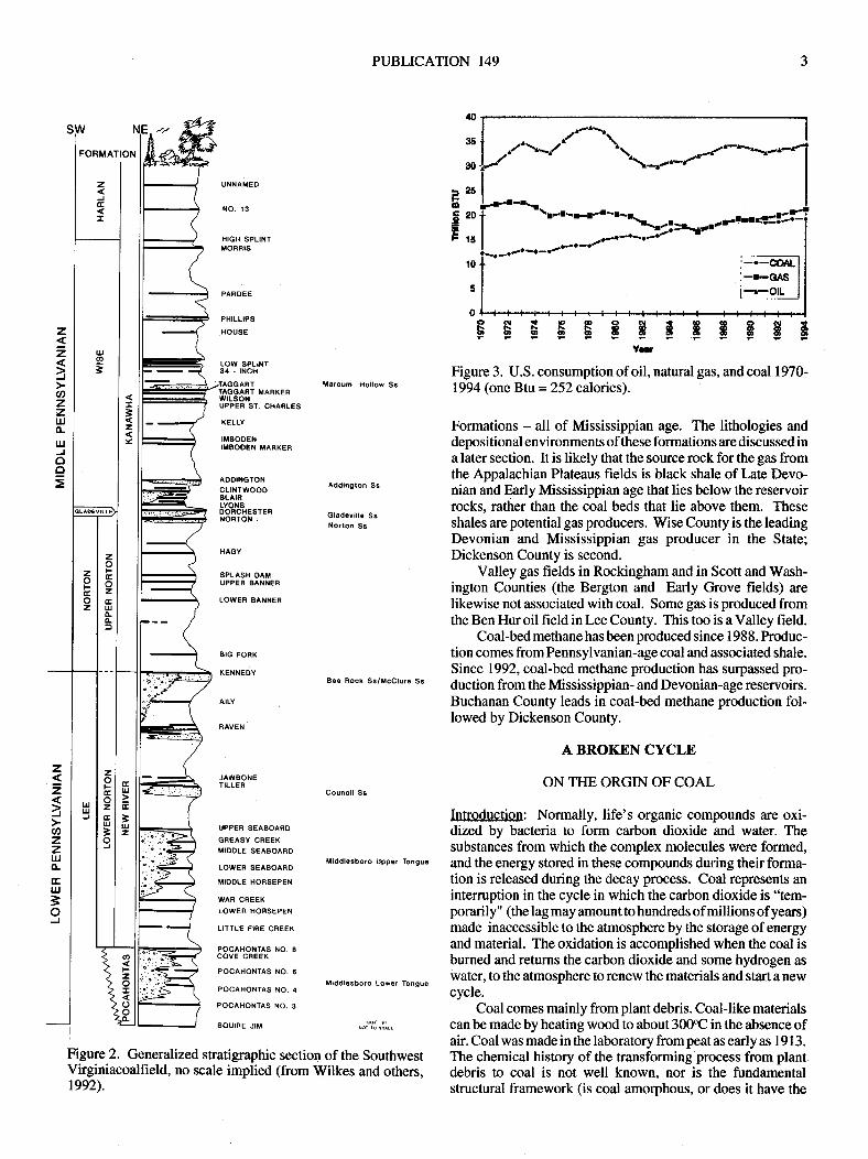
feedstock. For example, the Early Pennsylvanian PocahontasNo. 3 coal, a low volatile, high-fixed-carbon coal, is usedextensively throughout the world in making coke for produc-ing steel. Some of the major coal beds of the Virginia plateausprovince are shown in stratigraphic sequence in Figure 2.
Theconsumption of coal in the United States continues toincrease (Figure 3). A full two-thirds of coal produced in theUnited States is now used by utilities for producing electricity.It is certain that coal will continue to be important to the woddeconomy far into the future, and that Virginia will continue toplay a vital role in the coal economy of the world for manyyears. This will be true even if other power sources are broughtto commercial development. Virginia currently produces about3.5 percent of the coal mined in the United States annually; itproduced about 36.7-million short tons in 1996.
COAL AND NATURAL GAS
Richmond basin: Methane, or natural gas, is commonlyassociated with coal, often in large quantities. Several wellswere drilled in the Richmond basin by commercial companiesto test the prospect ofproducing gas (or oil) from the Triassic-age rocks. The presence of gas in the basin was well knownfrom the eadiest days of mining when violent and frequentmine explosions were caused by ignition of this gas as the coalwas being mined.
Valley coalfields near Blacksburg: In a program funded by theU.S. Department of Energy, the Virginia Division of MineralResources drilled three holes to assess the coal-bed methane andresources of coal strata within the Mississippian-age Price For-mation in the vicinity of Blacksburg (Stanley and Schultz, 1983).Iarge quantities of gas were known to occur in these coals from
miners' reports and from explosions at several mines. Thedrilling program was designed to determine subsurface locationsand thicknesses ofPrice coal beds and to evaluate the amount andquality of the methane contained in these coals. Drilling siteswere chosen in areas ovedain by rock strata thick enough (at least
100ofeet) to seal the gas within thecoal, andthesites werelocatedfarenough away from surface mines to preclude orreduce loss ofgas through this possible egrcss.
Gas contentof coal samples recovered from the drill coreswas calculated bydegassing thecoal at the surface andmeasur-ing the volume of water it displaced. Maximum total quantitiesofgas thus released and measured were about 12 cubic centi-meters/gram of coal.
An economic feasibility study for producing the gas
contained in the coal was prepared by Gruy Petroleum Tech-nology Incorporated. This study, which is included in thereport by Stanley and Schultz (1983), indicated that commer-cial production would be marginally profitable. ftedicted totalrecovery of gas was estimated in the feasibility study for threewell-spacing strategies - production was predicted for I 0-acre,20-aqe, and 40-acre well spacings. Gas recovery was pre-dicted to be best (about 5 I percent) for the I 0-acre centers, andwell life was predicted to be longest (about 15 years) for 40-acre centers. Analyses included incremental profit-and-loss,balance-sheet, and cash-flow estimates together with othervariables necessary in making gas production in the area aprofitable venture.
Appalachian Plateaus and non-coal Valley Gas fields: Prior to1988 most of Virginia's gas production (19,l72-million cubicfeet) was from the Appalachian Plateaus area, and was notassociated with coal. The major natural gas producers in theAppalachian Plateaus are the Price, Greenbrier, and Hinton
PI]BLICATION 149
FOBMATION
UilNAMED
NO. 13
HIGH SPLINIMOFRIS
32Y
z
=fg)zzUJo-IJJJoo
PAROEE
PHILLIPS
HOUSE
LOW SPLINT34 - |NCH
FE$$F$E$$yaf
Figure 2. Genenlized stratigraphic section of the SouthwestVirginiacoalfield, no scale implied (from Wilkes and orhers,1992).
Figure 3. U.S. consumption of oil, natural gas, and coal 1970-1994 (one Btu=252 calories).
Formations - all of Mississippian age. The lithologies anddepositional environments of these formations are discussed ina later section. It is likely that the source rock for the gas fromthe Appalachian Plateaus fields is black shale of Late Devo-nian and E.arly Mssissippian age that lies below the reservoirrocks, rather than the coal beds that lie above them. Theseshales are potential gas producers. Wise County is the leadingDevonian and Mississippian gas producer in the State;Dickenson County is second.
Valley gas fields in Rockingham and in Scott and Wash-ington Counties (the Bergton and Early Grove fields) arelikewise not associated with coal. Some gas is produced fromthe Ben Hur oil field in Lee County. This too is a Valley field.
Coal-bed methane has been produced since 1 98 8 . Produc-tion comes from Pennsylvanian-age coal and associated shale.Since 1992, coal-bed methane production has surpassed pro-duction from the Mississippian- and Devonian-age reservoirs.Buchanan County leads in coal-bed methane production fol-lowed by Dickenson County.
A BROI(I'-N CYCLE
ON THE ORGIN OF COAL
Introduction: Normally, life's organic compounds are oxi-dized by bacteria to form carbon dioxide and water. Thesubstances from which the complex molecules were formed,and the energy stored in these compounds during their forma-tion is released during the decay process. Coal represents anintemrption in the cycle in which the carbon dioxide is "tem-porarily" (the lag may amount to hundreds of millions of years)made inaccessible to the atmosphere by the storage of energyand material. The oxidation is accomplished when the coal isburned and returns the carbon dioxide and some hydrogen aswater, to the atmosphere to renew the materials and start a newcycle.
Coal comes mainly from plant debris. Coal-like materialscan be made by heating wood to about 30OC in the absence ofair. Coal was made in the laboratory from peat as early as I 9 I 3 .
The chemical history of the transforming process from plantdebris to coal is not well known. nor is the fundamentalstructural framework (is coal amorphous, or does it have the
Uarcum Hollow SsMARKER
r. CHARLES
KELLY
IMEOOENIMBOOEN MARKER
AODINGTONcLtt{TwoooBLAIRLYOXSDOFC}IESTERNORTON ;
HAGY
SPLASH OATIUPPER BANNER
LOWEF BANNER
BIG FORK
KEIlNEDY
AILY
RAVEN
JAWSONETILLEN
UPPER SEABOARO
GREASY CREEKMIDOLE SEABOARO
LOW€R SEASOARD
MIODLE HORSEPEN
WAR CREEK
LOWER H09SEPEN
LITTLE FIRE CREEK
POCAHONTAS NO.8COVE Cf,EEK
POCAHONTAS NO.8
POCAHONTAS NO.4
POCAHONTAS NO.3
SOUIRE JIM
Addin0ton S6
Gladovill€ SsNorton Ss
z2lazzIJJoaruJ3oJ
UuJ
Bee Rock Ss/ilccluro Ss
Council Sa
Middlgsboro Upp€r Tonguo
Middlesboro Low€r Tongue

VIRGINIA DryISION OF MINERAL RESOURCES
$aphite or the diamond structure?), nor the fundamentalchemical make-up (is coal mainly composed of simple, ali-phatic, or complex, aromatic compounds?) known. A majorpart of coal's intractability in these matters owes to its generalinsolubility without oxidation (which destroys compounds andstructures), its opacity to light, and its feeble X-ray patterns.Coal has resisted numerous and ingenious efforts of analysesin the test tube, under the microscope, and in the X-raymachine. Furthermore, the relative contributions from thewood of lignin, a complex and oxidation-resistant substance,and cellulose, a simpler and less resistant material, in formingcoal is now, and has been for years, in debate. Finally, therelative influences of time, heat, and pressure of burial or ofcompressive deformation are not fu1ly determined. Two ex-amples may be used to show, however, thatpressure is important.Peat has been found in concretions sunounded by coal in ancientbeds of rock showing that pressure has had a great, and time asmall, influence in forming coal. Wooden mine-roof supports inplaces have had their centers turned to coal by the weight oftherocks they support.
Studies by Trent and others (1982) have shown thattectonic compression probably does substitute for burial pres-sure as may be inferred from the finding that carbon content ofcoal increases toward the center and down plunge inindividualfolds in southeastern West Virginia, including the Pocahontassyncline, and elsewhere. Cecil and others (19'79) have arguedthat fold crests and troughs may be areas of low pressure wheregas is released and where there is a concomitant increase incarbon content or coal rank. The most critical factor in determingcoal rank is probably depth of burial, because of its directrelation to temperature thrcugh the geothermal gradient (about2'Cll}O feet). Original composition is also important.
Peat-coal's progenitor: Peat is an early stage in the coal-makingprocess in which bacteria-aided decomposition has proceeded bydestroying molecular bonds and driving off hydrogen and oxy-gen to form humic acid from lignin and cellulose. The result isa "solid" mass of brown to black, fibrous and spongy to grease-like peat with acarbon content enriched some 5 to l0percent withregard to the original materials. This carbonization brings aboutan increase in the fuel value of the substance: moisture-free peatcontains as much as 2000 more Btu/pound than does dried wood.Grating used to burn wood will melt when used for peat. In ligniteand in bituminous coal the carbon content is raised still higher andthe energy content is also higher.
Although there is abundant evidence that coal beds oftheAppalachians from Alabama to Nova Scotia accumulatedunder tropical conditions, the greatest part of modern peatdeposits formed at relatively high latitudes. Deposits inFinland, the former Soviet Union, Ireland, and Canada areexamples. These deposits formed over the past I 5,000 years orso, the time since the melting of the world's great ice sheets.
Sizable peat deposits are located in the eastern UnitedStates in Maine, New York, New Jersey, North Carolina, andFlorida. The largest accumulation ofpeat in Virginia lies in theGreat Dismal Swamp (Figure 4, 5); the peat, which formedover the last 10,000 years and is forming today, is locally about15 feet thick, and in places contains full-sized tree trunks -everywhere it contains microscopic pollen and spores. Theseremains show that the trees which formed the bulk of the peatare the same ones growing in virgin stands today, including
Figure 4. Chaned remains of forest and peat in the GreatDjsmal Swamo.
Figure 5. Burned and preserved peat. Photographs takenshortly after the great fire in October 1930; courtesy VirginiaDivision of Forestry (print by T. M. Gathright, II).
mainly cypress, Atlantic white cedar, and gum.
The Great Dismal Swamp as a coal-forming model: Theformation process of the Great Dismal Swamp peat makes a

VIRGINIA DIVISION OF MINERAL RESOURCES
$aphite or the diamond structure?), nor the fundamentalchemical make-up (is coal mainly composed of simple, ali-phatic, or complex, aromatic compounds?) known. A majorpart of coal's intractability in these matters owes to its generalinsolubility without oxidation (which destroys compounds andstructures), its opacity to light, and its feeble X-ray patterns.Coal has resisted numerous and ingenious efforts ofanalysesin the test tube, under the microscope, and in the X-raymachine. Furthermore, the relative contributions from thewood of lignin, a complex and oxidation-resistant substance,and cellulose, a simpler and less resistant material, in formingcoal is now, and has been for years, in debate. Finally, therelative influences of time, heat, and pressure of burial or ofcompressive deformation are not fully determined. Two ex-amples maybeusedto show, however, thatpressure is important.Peat has been found in concretions sunounded by coal in ancientbeds ofrock showing that pressure has had a great, and time asmall, influence in forming coal. Wooden mine-roof supports inplaces have had their centers turned to coal by the weight oftherocks they support.
Studies by Trent and others (1982) have shown thattectonic compression probably does substitute for burial pres-sure as may be inferred from the finding that carbon content ofcoal increases toward the center and down plunge in individualfolds in southeastern West Virginia, including the Pocahontassyncline, and elsewhere. Cecil and others (1979) have arguedthat fold crests and troughs may be areas of low pressure wheregas is released and where there is a concomitant ihcrease incarbon content orcoal rank. The mostcritical factor in determingcoal rank is probably depth of burial, because of its directrelation to temperature through the geothermal gradient (about2"C/lOO feet). Original composition is also important.
Peat--coal's orogenitor: Peat is an eady stage in the coal-makingprocess in which bacteria-aideddecomposition has proceeded bydestroying molecular bonds and driving offhydrogen and oxy-gen to form humic acid from lignin and cellulose. The result isa "solid" mass of brown to black, fibrous and spongy to grease-like peat with a carbon content enriched some 5 to 1 0 percent withregard to the original materials. This carbonization brings aboutan increase in the fuel value of the substance: moisture-free peatcontains as much as 2000 more Btu/pound than does dried wood.Grating used to burn wood will melt when used forpeat. In ligniteand in bituminous coal the carbon content is raised still higher andthe energy content is also higher.
Although there is abundant evidence that coal beds of theAppalachians from Alabama to Nova Scotia accumulatedunder tropical conditions, the greatest part of modern peatdeposits formed at relatively high latitudes. Deposits inFinland, the former Soviet Union, Ireland, and Canada areexamples. These deposits formed over the past 15,000 years orso, the time since the melting of the world's great ice sheets.
Sizable peat deposits are located in the eastern UnitedStates in Maine, New York, New Jersey, North Carolina, andFlorida. The largest accumulation of peat in Virginia lies in theGreat Dismal Swamp (Figure 4, 5); the peat, which formedover the last 10,000 years and is forming today, is locally about15 feet thick, and in places contains full-sized tree trunks -everywhere it contains microscopic pollen and spores. Theseremains show that the trees which formed the bulk of tbe peatare the same ones growing in virgin stands today, including
4. Charred remains of forest and peat in the GreatSwamo.
FigureDismal
Figure 5. Burned and preserved peat. Photographs takenshortly after the great fire in October 1930; courtesy VirginiaDivision of Forestry (print by T. M. Gathright, II).
mainly cypress, Atlantic white cedar, and gum.
The Great Dismal Swamp as a coal-forming model: Theformation process of the Great Dismal Swamp peat makes a

PTJBLICATION I49
very incomplete model for the various coal formations ofVirginia, but it does present a vivid picture of early stages ofcoalification. The origin of the Great Dismal Swamp and itspeat began with the formation of a low-lying coastal arearesulting from the gradual withdrawal of the waters of theAtlantic Ocean. Fall of sea level in response to growth ofglaciers was completed less than 25,000 years ago. Later, assea level rose, water tables near the coast also rose. Drainageon the newly created, gently sloping land became danmed, andgrasslands and forested lands were slowly flooded by sluggishstream waters. Oxygen in the shallow waters was depleted byits union with fallen vegetation. Aerobic bacterial growth wasimpeded by the oxygen depletion and, later on, growth ofanaerobes was stopped by the accumulation of humic acid, a"waste product'' of the bacteria. As fallen vegetation chokedthe stream channels, the dark, antiseptic waters of the swamprose higher and vegetation continued to accumulate in thestream channels and on the floor of the swamp. Once thestreams were dammed, they were too slow moving to carryparticles larger than clay-size, which are difficult to erode.Hence, the peat that accumulated was free of sediments.Ancient stream channels of the Great Dismal Swamp arereadily seen in Figure 6.
The coals of Appalachia and the Great Dismal Swamppeat differ in many important ways. Aside from the differencesin age and types of plants forming the deposits, major distinc-tions are that the Appalachian coals formed over a veryextensive area andconsists ofa series ofcoal beds separated bysedimentary rocks up to hundreds of feet thick.
It is estimated that it takes about 20 feet of plant debris toproduce seven feet of peat or a foot of coal. Thus, a l0-foofthick coal bed represents 200 feet of plant debris, partiallydecayed, compressed, and otherwise altered. Compaction islargely accomplished by the deposition of sediment over thepeat and by its drying before or after burial by the sediment.Fresh peat is about 80 to 90 percent water by weight. Some ofthe carbon enrichment must take place late in the stage ofcoalification, because methane is trapped in the coal; it wouldnot likely be trapped in the porous and gas-permeable peat thatpreceded it.
The producl One coal bed of the Appalachians, the Pittsburghseam in the Pennsylvanian Systenr, covers an unbroken area ofabout 6000 square miles in contiguous parts of Pennsylvania,Ohio, and West Virgini4 and is up to 13 feet thick. Great depositsof peat formed in slowly subsiding swampy areas, that marinewater did not flood. Above the Pittsburgh seam, and others aswell, are sediments that indicate an increase in stream gradientsor, alternatively, a rise of the nearby sea as continental or marinedeposits were formed in the area. Thus, peat accumulated alongan expansive coastal plain from Pennsylvania to Alabama attimes during the Carboniferous time.
The oldest coals in the State are within the Price Formation@arly Mississippian time). Following a marine incursion re-corded in the Maccrady and Greenbrier Formations, which lieabove the Price, continental conditions were again graduallyestablished. By Early Pennsylvanian time, expansive peats thatformed the Pocahontas coals began to accumulate in what is now
the Appalachian Plateaus area of Virginia. Still later, mineablecoal formed in the Mesozoic-age basin west of Richmond.
SOME ANCIENT MSTORY
A WORLD SO FULL OF INTERESTINGTHINGS
The history of the earth, which at times is presented sooffhandedly by geologists, was pieced together from detailedstudies of local geology. The work did and does now prcceedfrom careful observations in the field, to geologic mapping ofrocks and stnrctures, to painstaking studies in the laboratory of thefossil, chemical, and mineral makeup of the rocks in order todeterminetheir age, origin, and economicpotential. This generalapproach to the study of geology eamestly began with the greatScottish geologist James Hutton a scant 200 years ago. In thebrief time since Hutton's day, methods of obtaining relative age(established mainly by fossils) and absolute age (made possibleby radiometric dating) have made it possible for rock strat& andthe events theyrecord, tobecorrelated throughoutthe world, andknined into a logical whole. This process is now so complete thatdescriptions of local areas and events must fit into the three-dimensional model ofthe entireearth as fashionedby geologists.In this model the third spatial dimension is also a measure of timeas represented by a selected vertical section ofrockplus thegapsin this record. It is evident thar a geologic history of Virginia isin many ways a geologic history of the earth.
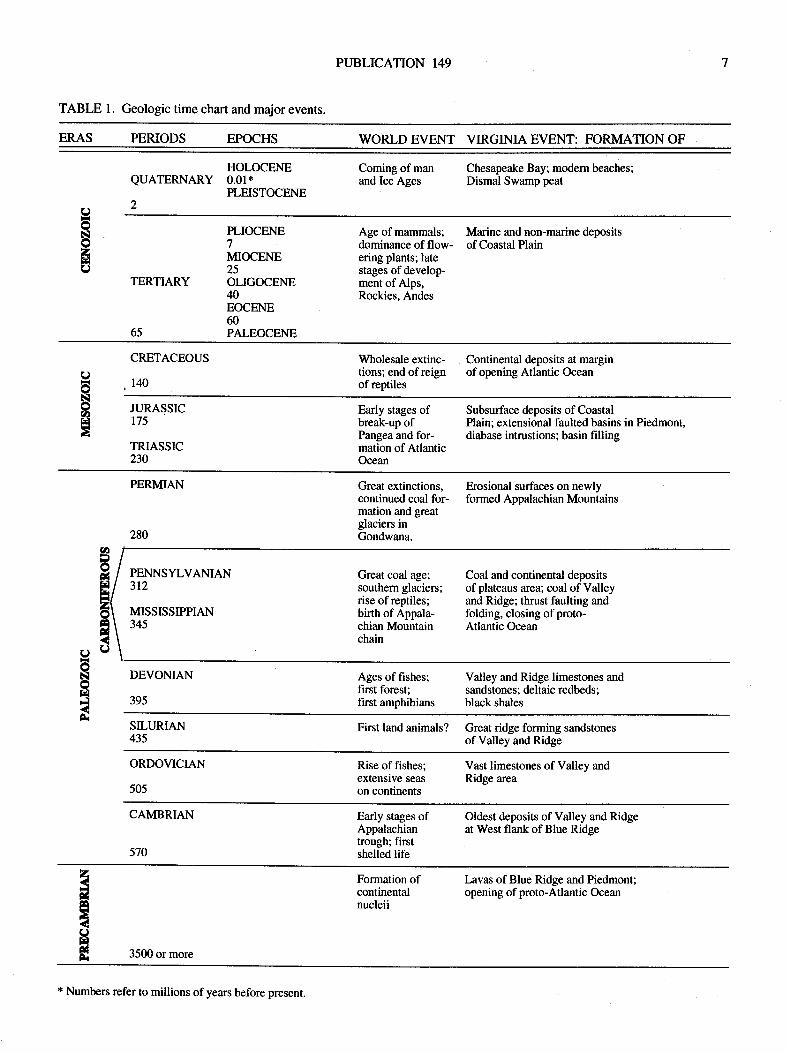
A generalized geologic column for the earth and for Virginiais presented in Table l. Thechief events forourconcern are thoseof the Carboniferous (Mississippian and Pennsylvanian) andearly and middle Mesozoic times.
Mostof the rocks that form the two-thirds of Virginialyingwest of the Fall Line, which separates the crystalline rocks of thePiedmont province from the sediments and sedimentary rocks ofthe Coastal Plain province, were formed before Carboniferoustime. By then, the great sedimentary basin that was to become theAppalachian Mountains, which extended from Newfoundland towesternmost Texas, was full of the rock waste being derived fromtectonic and volcanic highland terranes lying to the east ofthebasin. This basin had been in existence since Early Cambriantime and extended west as far as Ohio and eastward tens of milesunder the present Blue Ridge Mountains and Piedmont province.
What an alien place Virginia would have been to us duringtheCarboniferous, orcoal age. Fromtheair, we would seeagreenlowland or swamp forest formed from a crowded, entangled massoflarge trees stretching out to the horizon north and south. Theclear, shallow watersofan unnamed sea would lie tothewest, andfar to the east would be barren, brown hills. A lacework ofsluggish coastal streams, distributaries formed from coalescingrills arising from the distant hinterland to the east, would definedeltas along the swampy shoreline. One large river woulddisappear toward lhe mountains to the south - this would be theancestral New River. Farther south, another stream, the ancestalFrench-Broad, would also extend back into the rising mountainmass. Just offshore wouldbe an extensivechain ofbarrierislandsfronting shallow lagoons. The scene mightremind us of the BackBay - Great Dismal Swamp area of southeastern Virginia or theshoreline of the Pamlico-Albemarle Sound area of North Caro-lina, or of the Florida Everglades.

?6.2J'
Estlcnatacn
- . trcl !rmr. ll
- Pacl til. tc a!.ant
--- Surtaca ccltau?rlttl. lil.r.trl
- Cdlcrrf cf Laa ot
,.clOcla: | 0.R. Wlralai.o.,
o Ocb.Roag.r..s|ilata An.rrccn lsa Co.
rc_-. o .W.W. O.Dcn (trt9l/ @ re teor
'
'sR\\t-IIt\\.20
-\
3ri
;ffia,1
?*ot2td
miles
VIRGINIA DIVISION OF MINERAL RESOURCES
Figure 6. Configuration of the base of Dismal Swamp peat showing obvious sfeam channels. Sea level is datum for bothtopography and peat base (from Oaks and Koch, 1973).
PUBLICATION 149
TABLE l. Geologic time chart and major events.
ERAS PERIODS EPOCHS WORLD EVENT VIRGINIA EVENT: FORMATION OF
HOLOCENEQUATERNARY O.OI*
PLEISTOCENEa
Coming of manand lce Ages
Chesapeake Bay; modern beaches;Dismal Swamp peat
c)55a(J
TERTIARY
65
PLIOCENE7MIOCENE25OLIGOCENE40EOCENE60PALEOCENE
Age of mammals;dominance of flow-ering plants; latestages of develop-ment of Alps,Rockies. Andes
Marine and non-marine depositsof Coastal Plain
CRETACEOUS
140
Wholesale extinc- Continental deposits at margintions; end of reign of opening Atlantic Oceanof reptiles
U6NooFI
JURASSIC175
TRIASSIC230
Early stages of Subsurface deposits ofCoastalbreak-up of Plain; extensional faulted basins in Piedmont,Pangea and for- diabase intrustions; basin fillingmation of AtlanticOcean
PERMIAN
280
PENNSYLVANIAN312
MISSISSIPPIAN345
Great extinctions, Erosional surfaces on newlycontinued coal for- formed Appalachian Mountainsmation and greatglaciers inGondwana.
Great coal age;southern glaciers;rise of reptiles;birth of Appala-chian Mountainchain
Coal and continental depositsof plateaus area; coal of Valleyand Ridge; thrust faulting andfolding, closing of proto-Atlantic Ocean
C)
55frlFlf
DEVONIAN
395
Ages of fishes;first forest;first amphibians
Valley and Ridge limestones andsandstones; deltaic redbeds;black shales
SILURIAN435
First land animals? Great ridge forming sandstonesof Valley and Ridge
ORDOVICIAN
50s
Rise of fishes;extensive season continents
Vast limestones of Valley andRidge area
CAMBRIAN
570
Early stages ofAppalachiantrough; firstshelled life
Oldest deposits of Valley and Ridgeat West flank of Blue Ridge
zxE
Hx
Formation ofcontinentalnucleii
Lavas of Blue Ridge and Piedmont;opening of proto-Atlantic Ocean
3500 or more
* Numbers refer to millions of years before present.
VIRGINIA DTVISION OF MINERAL RESOURCES
OF LIFE
The ancient cast The climate would be similar to that of thepresent Florida Keys. The swampy floor of the forest wouldhave familiar algae, mushrooms, mosses, and ferns, but littleleaf litter, and there would be no flowers nor grass (Plates 2, 3,4, and 5 ). Some 100 feet above us would be a 'tanopy" formedfrom nearly branchless, needle-leaved trees, that could aloneoffer no more than pathways of shade, but growing in profu-sion. their boles would shade and darken the forest floor. Thelargest of these trees was the important coal-forming groupknown as lycopods whose closest relatives today are the little"club mosses" and "running cedar," which are herbaceouscreepers on modern, damp, cool forest floors. Tree ferns(which exist today in the tropical rain forests) were other large,arborescent forms.
Noises in the forest would consist of the dry rustle of theneedles of these "Eees," the drone of giant dragonflys, and,perhaps, the croaking of some of the eady, distant relatives offrogs and salamanders, and the belching of lung fish. This fish,the ancestral vertebrate stock, had lived on from past ages tobecome cohabitants of the land along with their offspring, theamphibians. There would be no singing of birds, for there werenone. Except for amphibians, insects, and spiders, and a singlegroup of reptiles, no other creature had evolved to hear them.
Besides sharks, primitive bony fish related to modern daysturgeon, and jawless eels, no fish of the sea would have beenfamiliar to us, and there was no form of life higher than fishes inthose waters. A few of the fishes were very large: one giant, aplacoderm, from a class including the frst fish with jaws,inhabited Late Devonian-age and possibly Early Mississippian-age nearshore areas of low salinity, including estuaries andsounds. Remains of this 3Gfoot-long, toothless, butpredatory,fish are found in black shale that represent stagnant bottoms ofinland waten.
The amphibians of these times deserve a further note, forthey bear witness to the frst struggling steps of vertebrates'conquest of the land. These giant steps in evolution, which werebeing paralleled by the plants' conquest ofdry land ttrough thedevelopment of the see{ were trod by animals of huge propor-tions as compared to their modern descendants, the frogs. Onegroup, known as labyrinthodontsbecause of thecomplex infold-ing of the enamel of their teeth, reached lengths of 12 feet. Theseforms were the rcotstock of the reptiles which are first knownfrom Pennsylvanian time and which became the dominant ani-mals of both land and sea throughout Mesozic time.
Invertebrate lifeofthe seas leaves arecord ofits existencefar superior to that of related forms on land. Some of the morecommon marine forms of Carboniferous time are shown inPlate 5. Reefs formed of rugose corals, productid brachiopods,frond-bearingbryozoa, and large-armed crinoids grew in shal-low, neady waveless areas of the inland sea. Many of thesegroups are extinct at the systematic level of order. One peculiarinvertebrate group arising in the coal age, was a large, marine,shelled, amoeba-like protozoan. The tests of these wheat-grain-shaped and wheat-grain-sized foraminiferans known as
fusulines were so abundant in places, for example, in parts ofTexas, Kansas, Indiana, and Illinois, as to form whole forma-tions of limestone - much as their modern formaminiferanrelatives do today in the shallow waters of the Bahama Islands.Other, much younger (lower Cenozoic) limestones of Egypt
madeof the shells of large, marine protozoans were usedin thebuilding of the great pyramids. The Mississippian-age SalemLimestone of Indiana, a widely used ornamental stone, ismainly skeletons of bryozoans and an eady fusuline.
Fusulines are peculiarin that they had no aperture and thatthe septa separating the individual chambers of their tests
became highly convoluted as they evolved. This odd geomefyand their wide geographic distribution, in spite of the fact thatthey were bottom dwellers, accounts for the fusulines beingranked as a "best" group of fossils for correlating rocks andevents around the world. The group became extinct before theend ofthe Paleozoic Era.
In rare instances throughout the very imperfect geologicrecord, the transitional environment between the sea and theland is preserved; much more rarely, remains of the life of thosehaunts are left juxtaposed for us to see. Perhaps the bestexample and best known of such deposits is the Mazon Creekbiota located about 60 miles southwest of Chicago. Thisunique collection of fossils occurs in the Francis Creek ShaleMember of the Cabondale Formation, which is Middle Penn-sylvanian age. Here, fossils of both marine and lerrestrialorganisms give a silent, but striking, account of climate andprovince, habitat and ecology, success and failure, evolutionand extinction. The Mazon Creek record of the non-marinefossils is so unique and spectacular as to be inexpressible save
for photographs of some of the forms found there, whichinclude insects, spiders, wofins, abundant and diverse plants,and lung fi sh--all preserved within ironstone concretions @lates3,4). Five feet above these fossiliferous beds, which were firstdescribed more than 100 years ago, is a 5-foot-thick coal bed,which records a time of wholly continental conditions.
AND ROCKS
... to keep the sea from transgressing the land: The Carbon-iferous-age rocks of southwestern Virginia (Figures 7, 8, 9, 10)
tell the story of a struggle between the sea and the land. Thegeneral geologic setting for the time is given in Figure 9, whichdepicts erosion of the newly uplifted Appalachian Moun0ains tothe east and a shallow sea to the west. As the land rose repeatedlyduring late Paleozoic time, rivers formed and entrenched as a
result of the uplift, quickened their pace and increased theirsediment load. Deltas built into the western sea were partiallyeroded by feeble waves and buried as the basin subsided. Theshallow sea held its shoreline in Virginia through much ofMississippian time, but at the time of the Bluefield Formation(Figure 7) it was pushed westward by such huge volumes ofsediment that it never again fully returned, though the cycle ofsubsidence and filling continued for millions of years.
The ancestral New River (Figure 9) was one of the riversborn during the time of tumultuous uplift known as theAlleghanian orogeny, which began in the Mississippian Pe-
riod. It and associated streams cut into the newly risenmountains and carried the sediments that formed the great
deltas of the Carboniferous age of southwest Virginia. TheNew River is one of only two streams that today flow northwest-wardly across the Valley and Ridge province to empty, eventu-ally, into the Gulf of Mexico. The other stream is the French-Broad River which, like the New, heads in the North CarolinaBlue Ridge Mountains. Other streams of the Valley and Ridgeprovince such as the 'tnighty" James and Potomac Rivers, have

Figure 7. Triassic, Carboniferoust, and Upper Devonian rocks of parts of Virginia.
Newark Supergroup*
III:--IIIII
Harlan Formation
Wise Formationx
Pocahontas Formation*
Bluestone Formation
Hinton Formation
Maccrady Shale
Price Formation*
Chattanooga Shale, Big StoneGapMember
Chemung Formation
UpperTriassic
III
PUBLICATION 149
GENERAL LITHOI.OGY AND DEPOSITIONAL EI\ryIRONMENT
Quartzose and feldspathic siltstone, sandstone, and conglomuate withsome dark colored shale wfr caal, and with diabase infrusions of mainlyJurassic age; fluvial and lacustine environrnents.
III IIITTI-III-I-II-I--
Mainly feldspathic and quarEose sandstone; river channels and otherfluvial environments.
Quartzose, feldspathic, micacmus sandstone, siltstone, and shale withabundant coat deltaic with local marine limestone and shale beds.
Similarto the Wise Formation.
otr
^()Lee Formation: repetitious quartz-ose sandstone and some interbed.ded siltstone, shale,and coal;marine barrier bars and also deltas.Mississippian and Pennsylvanian
New River Formation: quartzosgfeldspathic sandstone, siltstone,shale and coalwith some congl*merates; deltaic.
oqoa
Sandstone, siltstone, and shale with coal: deltaic.
Mainly gray and red shale with some sandstone and subgraywacke andlittle coal and limestone; bay and lagoonal.
Conglomerate and sandstone; barrier bar.
Reddish. calcareous shale and siltstone and interbedded sandstone:barrier bars and delta, intergrown.
Grayish shale and interbedded limestone with some coal; bay and delta.
Fossiliferous, crystalline and oolitic limestone; shallow, marine shelf.
Red shale with some sandstone, siltstone, salt, and gypsum; lagmnaland deltaic.
Sandstone, siltstone, shale, and coal - loeally conglomeratic; marinebarrier bay, lagoonal, and deltaic.
Black shale and siltstone; bay.
Sandstone, shale, siltstone, and some conglomeraie; shallow marineand deltaic.
I After Englund (1979)
* Onetime or currently important coal producing interval in Virginia.
l0 VIRGINIA DIVISION OF MINERAL RESOURCES
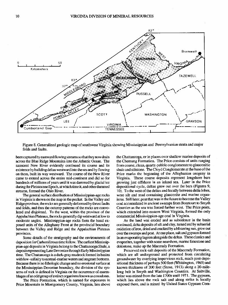
Figure 8. Generalized geologic map of southwest Virginia showing Mssissippian and Pennsylvanian strata and majorfolds and faults.
been captured by easnvard flowing streams so that they now drainacross the Blue Ridge Mountains into the Atlantic Ocean. Thenanscent New River evidently continued its course and itsexistence by building deltas westward into the sea and by flowingon them, built its way westward. The course of the New Rivercame to extend across the entire mid+ontinent and did so forhundreds of millions of years until it was dammed by glacial iceduring the Pleistocene Epoch, at which time it, and other dammedstreams, formed the Ohio River.
The general surface distribution of Mississippian-age rocksin Vkginia is shown on the map in the pocket. In the Valley andRidge province, therocks are generally deformed by thrust faultsand folds, and thus the outcrop patterns of the rocks are convo-luted and disjointed. To the west, within the province of theAppalachian Plateaus, the rocks generally dip westward at low tomoderate angles. Mississippian-age rocks form the basal ex-posed units of the Alleghany Front at the provincial boundarybetween the Valley and Ridge and the Appalachian Plateausprovinces.
Some details of the stratigraphy and the environments ofdeposition forCartoniferous time follow. The earliestMississip-pian-age deposits in Virginiabelongto theChattanooga Shale, adeposit representing Late Devonian through Eady Mississippiantime. The Chattanooga is a dark-gray mudrock formed in basinswithlow -salinity to normal-marine waters and stagnantbottoms.Because there is no lithologic change and no erosional surface atthe Mississippian-Devonian boundary, the division of the sys-tems of rock is defined in Virginia on the occunence of assem-blages of an odd groupof extinct organisms known as conodonts.
The Price Formation, which is named for exposures inPrice Mountain in Montgomery County, Virginia, lies above
the Chattanooga, or in places over shallow marine deposits ofthe Chemung Formation. The Price consists of units rangingfrom coarse, clean, quartz-pebble conglomerate to glauconiticshale and siltstone. The Cloyd Conglomerate at the base of thePrice marks the beginning of the Alleghanian orogeny inVirginia. These coarse deposits represent longshore barsgrowing just offshore in an inland sea. Later in the Pricedepositional cycle, deltas grew out over the bars (Figures 9,10). To the west of the deltas and locally between delta lobes,were silt and mud containing glauconite and marine organ-isms. Still later, peat that was in the future to become the Valleycoal accumulated in ancient swamps from Botetourt to SmythCounties as the sea was forced farther west. The Price peats,
which extended into eastern West Virginia, formed the onlycommercial Mississippian-age coal in Virginia.
As the land was eroded and as subsidence in the basin
continued, delta deposits ofsilt and clay, turned red by subaerialoxidation of iron, dried and cracked by a blistering sun, grew outover the swamps and peat. At one place, salt and gypsum formedin an evaporating lagoon alongside the deltas. These clastics and
evaporites, together with some nearshore, marine limestone and
dolostone, make up the Maccrady Formation.Preserved rock-salt deposits of the Maccrady Formation,
which are all underground and protected from circulatinggroundwater by overlying impervious rock, reach post-depo-
sitional thickness of perhaps 500 feet (Whittington, 1965) and
known thickness of 200 feet (Stose, 1913) along a 2O-mile-
long belt in Smyth and Washington Counties. At Saltville,brine was mined from the late 1700s until 1971. The gypsum'which lies above the rock salt and along strike is locallyexposed there, and is mined by United States Gypsum Com-
K ilomelers

PUBLICATION 149
Figure 9. General position of seas and lands in eastern United States during Carboniferous time. The entire area shown was land,except for the Pocahontas basin, in Early Pennsylvanian time. Later, the Middle Pennsylvanian inland sea invaded the areas asfar north as northwestern Ohio. After several sources in Donaldson and others (1979). Cross sectionA- A': I - Price Formationbarrier bar, trangressive; 2 - Maccrady Formation deltaic redbeds, regressive; 3 - Greenbrier Limestone marine, transgressive; 4-UpperMississippian shale and sandstone,regressive;5 - LeeFormationbarrierbar, transgressive;6 - Pocahontas deltaicdepositsincluding coaliT - Pocahontas sea.
11
pany. At l,ocust Cove in Smyth County the gypsum occurs asisolated blocks up to 200 feet long. The blocks representformerly layered masses broken apart by movement on theSaltville fault. At Plasterco in Washington County the gypsumoccurs in broken and layered masses along and below theSaltville fault. The Maccrady Formation reaches a thickness ofsome 1600 feet partly as a result of plastic flow of the salts inthe unit. The flow was caused by the stresses induced byfaulting and associated folding.
Following the development of the tidal and shallow ma-rine Maccrady deposits; the sea gained ascendancy once againand the water of the Greenbrier sea swept eastward beyond thepresent valley of the North Fork of the Holston River in
Washington County. The Greenbrier Limestone that formed inthe sea is largely a clastic limestone made up of oolites, shellhash of chiefly crinoid and blastoid stems, together with somecalyxes of these forms, bryozoans, and brachipods. Today,oolites form in the warm, clear hypersaline waters of theBahama Platform southeast of Andros Island where calciumcarbonate is precipitated repeatedly on nucleii rolled by wind-and tide-forced currents and waves. We can imagine that attimes during deposition of the Late Mississippian-age Green-brier Formation that the nearshore sea was teeming with lifewhere deeper waters of the sea upwelled and where lifeassembled in reefy masses. Farthef shoreward, and at timesthroughout the whole shallow platform stretching from Vir-
(/r4r>oFT-rssrffir,rrv-JsO\
PENNSYLVANIAN
,;9xlr
./,
il
,''/:fr,"/ / l58En9lT,S

t2 VIRGINIA DIVISION OF MINERAL RESOI.JRCES
Figwe 10. kndardseaofpartoffteAppalachianbasindningEarlyMississippian tfune wtlen thePrie Fmrnation was being &posited.Dagonallineistlrcapproximatelocationoftlepaleoequalor. Depos-its in fte Ohio Bay are represented by trc Charanmga black shale.After de Witt and Mc Grew (199).
ginia into the western mid-continent, wave-agiCated, waterenriched in mineral matter by partial evaporation producedgrowing oolites intermixed with shells of lifeless organisms,especially crinoid stems. This is the last time that the seaextended beyond the area we know as the Appalachian Pla-teaus to reach into the area of the Valley and Ridge province,and itis also the lasttime that amajorPaleozoic-age limestoneformed in Virginia.
The Bluefield Formation, which conformably overlies theGreenbrier, contains wholly marine and marginally marine tocontinental deposits, including some thin coal beds and tracksof a vertebrate that probably represent an amphibian(Humphreville, 1981).
Another major uplift of the hinterland is reflected in thebasal deposits of the Hinton Formation, which consist of anearly purequartz sandstone indicating a stable shelf on whichwaves could winnow clay from sand. Higher in the Hinton arered siltstone, sand, shale, thin coal beds, and another purequartz sandstone. These deposits of the Hinton are ovedain bydark-gray and mottled shale of the Bluestone Formation. Thisbrackish to marine shale is overlain by other marginal marinedeposits of the Bluestone, which includes a red membercontaining continental beds. Thin coal beds representingcoastal swamps are found in two units of the BluestoneFormation.
The uppermost part of the Bluestone grades along strikeinto gray, poody sorted, micaceous sandstones of the PocalnntasFormation, which contains the fossil fern, Neuropterispocahontas, an Early Pennsylvanian-age form. Here onceagain is a boundary problem. As in the Chattanooga Shalediscussed earlier, where deposition is continuous across ageologic time boundary, some arbitrary method must be usedto divide the rocks as to which lie above and which below theboundary plane. The Pocahontas Formation containingNeuropteris pocahontas and age-equivalent parts ofthe Blue-stone are considered to be Early Pennsylvanian-age. Generalenvironments during Late Bluestone-Eady Pocahontas timeare similar to those of Price time shown in Figure 9.
The delta-building of Early Pennsylvanian time beganwith deposition of the sand of the Pocahontas Formation. Thissand was supplied by the anceshal New River and relatedstreams whose head-waters lay in the mountains forming to theeast of the deltas. As the basin continued to subside, sand, mudand peat formed in the swamps on the delta plain. In front ofthe deltas were longshore bars and to the northwest, theswamps were not inundated by sea water.
There are seven coal beds in the Pocahontas Formation(twoadditional "Pocahontas" coals, numbers 8 and9, areintheNew River Formation) and one of these, "Pokie 3," is the mostproduced coal in Virginia. This coal, which was frst mined108 years ago at Pocahontas, Virgini4 in Tazewell County, isknown throughout the world because of its purity and itsexcellent coking quality. These characteristics make it aprimemetallurgical or'tnet" coal. It was mined extensively innorthern Tazewell County from 1883 into the 1950s. Anexhibition mine near the town of Pocahontas and reclaimedstrip benches near the mine are among the few obvious remind-ers of western Virginia's first coal production; some 224.9-million shorttons ofthe Pokie 3 remain as reserves inTazewellCounty. More than 25-million short tons of reserves are inBuchanan County. The value ofPocahontas No. 3 is reflectedin the efforts used to mine it through deep shafts sunk some1200 feet below the surface in Buchanan County. Thesemining operations, begun in 1970, had produced about 139-million tons of coal by 1996 (data fromVirginia Department ofLabor and Industry, various issues; and Department of Mines,Minerals and Energy files).
Following deposition of the Pocahontas Formation,longshore-bar sand of the Lee Formation dvanced over aneroded surface ofthe Pocahontas and Bluestone Formations andintertongued with the developing deltaof the New RiverForma-tion and the lagoonal and coastal swamp deposits of the NortonFormation. Both the Norton andNew RiverFormations containimportant, commercially mined coal beds. The Pocahontas andNew River Formations together have 19 producing coal beds.
The Norton Formation contains fine' to coane-glainedsedimentary rocks which generally contain quartz and feldspar.At least 13 named coals occur within the Norton in Virginia.These marginal marine to lower dela-plain sediments of theNorton are ovedain by a massive sandstone which is locallyfeldspathic. This roch which represens an ancient bar deposit"is up to 120 feet thick and is an important marker bed where itoccurs in Pennsylvanian-age strata of Virginia. The overlyingWise Formation rcpresents a chiefly continental depositionalsequerrce similar to tlre Norton. The Wise contains slightly muesandstone tran tlp Norto4 and also contains two thin unia bearingmryinefossils(Eby, l923;Engluttd, 1979). BothtpNortonandWise
PT'BLICATION I49
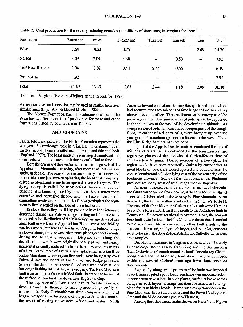
Table 2. Coal production for the seven producing counties (in millions of short tons) in Virginia for 1996t.
13
Formation Buchanan Wise Dickenson Tazewell Russell I.ee Total
Wise
Norton
Lee/ New River
Pocahontas
t.64
3.09
2.M
7.92
2.44
r0.22
2.O9
0.82
0.75
1.68
0.44
0.53
0.65
2.49 14;10
7.93
6.39
7.92
Total 14.69 13.13 2.87 2.091.182.44 36.40
rData from Virginia Division of Mines annual report for 1996.
Formations have sandstons that can be usd as rnarker beds oversizeable areas @by, 1923; Nolde and Mtchell, 1984).
The Norton Formation has 11 producing coal beds; theWise has 27. Some details of production for these and otherformations, listed by county, are in Table 2.
AND MOI.'NTAINS
Faults. folds. andpuzzles: The Harlan Formation represents theyoungest Paleozoic-age rock in Virginia. It contains fluvialsandstone, conglomerate, siltstone, mudrock, and thin coal beds@nglund, 1979). The basal sandstone is in deep channels cut intoolder beds, which indicates uplift during early Harlan time.
Both the origin and the mechanics of structural growth of theAppalachian Mountains are today, after more than 150 years ofstudy, in debate. The reason for the uncertainty is that new andreborn ideas arejust now supplanting the ideas that were con-ceived, evolved, andrefinedoveraperiodofsome l00years. Thedying concept is called the geosynclinal theory of mounlainbuilding; it is being replaced by plate tectonics, a much moreextensive and pervasive ft*ry, and one backed with morecompelling evidence. In the minds of most geologists the argu-ment is firmly settled on the side of plate tectonics.
Rocks in the Valley and Ridge province have been intenselydeformed during late Paleozoic-age folding and faulting as isreflected in the distribution of the Mssissippian-age shata of thisarea" Farther west, in the Appalachian Plateaus province, foldingwas less severe, buthere as elsewhere in Virgini4 paleozoic-agerocks were transported westward on thrustplanes, ordecollements,during the Alleghany orogeny. Displacement along thedecollements, which were originally nearly planar and nearlyhorizontal or gently inclined surfaces, in places amounts to tensof miles. An example of a very large displacement is at the BlueRidge Mountains where crystalline rocks were brought up overPaleozoic-age sediments of the Valley and Ridge province.Some of the decollements were folded as a result of relativelylate-stage faulting in the Alleghany orogeny. The pine Mountainfault is an example of such a folded fault. Its trace can be seen atthe surface in structural windows near Big Stone Gap.
The sequence of deformational events for late paleozoictime is currently thought to have proceeded generally asfollows. In Early Carboniferous time compressional upliftbegan in response to the closing of the proto-Atlantic ocean asthe result of rafting of western Africa and eastern North
America toward each other. During this uplift, sediment whichhad accumulated through eons of time began to buckle and riseabove the sea's surface. Thus, sediment on the outer part ofthegrowing continent became sources of sediment to be depositedin the inland sea to the west of the developing highlands. Ascompression of sediment continued, deeper parts of the troughfloor, or earlier raised parts of it, were brought up over theyounger and unmetamorphosed sediment to the west. Thus,the Blue Ridge Mountains were born.
Uplift of the Appalachian Mountains continued for iens ofmillions of years, as is evidenced by the transgressive andregressive phases of the deposits of Carboniferous time ofsouthwestern Virginia. During episodes of active uplift, theregion would have been repeatedly shaken by earthquakes as
$eat blocks of rock were forced upward and outward from thezone of continental collision lying east of the present edge of thePiedmont province. Some of the fault zones in the Piedmontprovince are today areas of small magnitude earthquakes.
An idea of the scale of the motion on these Late Paleozoic-age faults can be gained from looking at the Pine Mountain thrustsheet, which is bounded on the westby the Pine Mountain and onthe east by the Hunter Valley or related faults (Figure 8, Plate 1).The trace of the Pine Mountain fault extends north some l0 milesbeyond the Russell Fork fault and south to the Jacksboro fault inTennessee. East-west rotational movement along the RussellForkfaultis 2to4miles. ThePineMountain thrust sheetiserodedto the northwest and is covered by other fault sheets to thesoutheast. It was originally much larger, and much larger sheetsexist to the east--the Blue Ridgq Pulaski, and Saltville fault sheetsare examples.
Decollement surfaces in Virginia are found within the earlyPaleozoic-age Rome (Early Cambrian) and the Martinsburg(Late Ordovician) Formations and the late Paleozoic-age Chatta-nooga Shale and the Maccrady Formation. Locally, coal bedswithin the several Carboniferous-age formations serve asdecollements.
Regionally, along strike, progress of the faults was inrpededas rock masses piled up, as local resistance was encountered, or:N pore prcssure was lost. In such plases, the faults broke acrosscompetent rock layers as ramps and then continued as bedding-plane faults at higher levels. It was such ramp transport on thePine Mountain thrust fault, that created the Powell Valley anti-cline and the Middlesboro syncline (Figure 8).
Among the other thrust faults shown on Plate I and Figure
l4 VIRGINIA DIVISION OF MINERAL RESOURCES
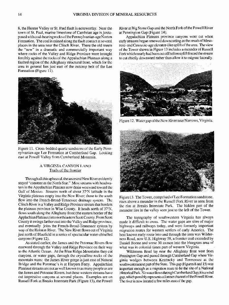
8, the Hunter Valley or St. Paul fault is noteworthy. Near thetown of St. Paul, marine limestone of Cambrian age is juxta-posed with coal-bearing rocks of the Pennsylvanian-ageNortonFormation. The coal is mined along the fault contact at severalplaces in the area near the Clinch River. There the old meetsthe "new" in a dramatic and commercially important waywhere rocks of the Valley and Ridge Province were broughtforcibly against the rocks of the Appalachian Plateaus along a
faulted region of the Alleghany structural front, which for thearea in general lies just east of the outcrop belt of the LeeFormation (Figure l1).
Figure I l. Cross-bedded quartz sandstone ofthe Early Penn-sylvanian-age Lee Formation at Cumberland Gap. Lookingeast at Powell Valley from Cumberland Mountain.
A VIRGINIA CANYON I-ANDTrails of the frontier
Through all this upheaval, the ancestral New Riverevidentlystayed "constant as the North Star." Most streams with headwa-ters in the Appalachian Plateaus now drain westward toward theGulf of Mexico. Streams north of about 37oN latitude in theVirginia plateaus empty into the New River; those to the southflow into the French-Broad-Tennessee drainage system. TheClinch River is a Valley and Ridge Province stream that bordenthe plateaus province in Wise County. It heads north of 37'N,flows south along the Alleghany front (the eastern border of theApplachian Plateaus) into northeastem Scott County. From ScottCounty it swings farther east into the Valley and Ridge province,and eventually joins the French-Broad-Tennessee system byway of the Holston River. The New River flows out of Virginiajust north of Bluefield in a series of spectacular water-chiselledcanyons (Figure l2).
As stated earlier, the James and the Potomac Rivers floweastward through the Valley and Ridge Province on their wayto the Atlantic Ocean. At the Blue Ridge Mountains they cutcanyons, or water gaps, tkough the crystalline rocks of themountain mass: the James River gorge is just east of NaturalBridge and the Potomac's is at Harpers Feny. AppalachianPlateaus streams are not as well known to as many people as arethe James and Potomac Rivers. but these western streams havecut impressive canyons at several places. Examples are onRussell Fork at Breaks Interstate Park (Figure l3), the Powell
River at Big Stone Gap and the North Fork of the Powell Riverat Pennington Gap (Figure l4).
Appalachian Plateaus province canyons were cut whenearly streams began renewed downcutting as the result of Meso-zoic- and Cenozoic-age elevator-like uplift of the area. The viewof the Tower shown in Figure i3 includes a meander of RussellFork which nearly had been cut off before uplift forced the stream
to cut chiefly downward rather than allow it to migrate laterally.
Figure 1 3. The Tower, comprised of Lee Formation sandstone,
rises above a meander in the Russell Fork River as seen fromthe rim at Breaks Interstate Park. The hidden part of themeander lies in the valley seen just to the left of the Tower.
The topography of southwestern Virginia has alwaysmade it difficult to cross. The water gaps are sites of majorhighways and railways today, and were formedy importantmigration routes for western settlers of early America. Thebest known early route into and through the area was Wilder-ness Road, now U.S. Highway 58, a frontier trail extended byDaniel Boone and some 30 axmen into the bluegrass area ofwhat was in colonial times part of western Virginia.
Wildemess Road lay near the Alleghany front west fromPennington Gap and passed through Cumbedand Gap where Vir-ginia wedges between Kentucky and Tennessee at thesouthwestemmostpafi of tlrc state. This gap (Figures 8 and 15) was
important enough as a migration route to be the site of a NationalHistorical Park. NowaterflowsthroughCumberlandGap; itisawindgap, which possibly represents a formerchannel of thePowell River.
The river is now located a few miles east of the gap.
Figure 12. Watergap of the New River nearNarrows, Virginia.

l4 VIRGINIA DIVISION OF MINERAL RESOURCES
8, the Hunter Valley or St. Paul fault is noteworthy. Near thetown of St. Paul, marine limestone of Cambrian age is juxta-posed with coal-bearing rocks of the Pennsylvanian-ageNortonFormation. The coal is mined along the fault contact at severalplaces in the area near the Clinch River. There the old meetsthe "new" in a dramatic and commercially important waywhere rocks of the Valley and Ridge Province were broughtforcibly against the rocks ofthe Appalachian Plateaus along afaulted region of the Alleghany structural front, which for thearea in general lies just east of the outcrop belt of the LeeFormation (Figure ll).
Figure I 1 Cross-bedded quartz sandstone of the Early Penn-sylvanian-age Lee Formation at Cumberland Gap. Lookingeast at Powell Valley from Cumberland Mountain.
A VIRGINIA CANYON LANDTrails of the frontier
Tbrough all this upheaval, the ancestral New Riverevidentlystayed "constant as the North Star." Most streams with headwa-ters in the Appalachian Plateaus now drain westward toward theGulf of Mexico. Streams north of about 37"N latitude in theVirginia plateaus empty into the New River; those to the southflow into the French-Broad-Tennessee drainage system. TheClinch River is a Valley and Ridge Province stream that bordersthe plateaus province in Wise County. It heads north of 37'N,flows south along the Alleghany front (the eastern border of theApplachian Plateaus) into northeastern ScottCounty. From ScottCounty it swings farther east into the Valley and Ridge province,and eventually joins the French-Broad-Tennessee system byway of the Holston River. The New River flows out of Virginiajust north of Bluefield in a series of spectacular water-chiselledcanyons (Figure 12).
As stated earlier, the James and the Potomac Rivers floweastward through the Valley and Ridge Province on their wayto the Atlantic Ocean. At the Blue Ridge Mountains they cutcanyons, or water gaps, though the crystalline rocks of themountain mass: the James River gorge is just east of NaturalBridge and the Potomac's is at Harpers Ferry. AppalachianPlateaus streams are not as well known to as many people as arethe James and Potomac Rivers, butthese western streams havecut impressive canyons at several places. Examples are onRussell Fork at Breaks Interstate Park (Figure 13), the Powell
River at Big Stone Gap and the North Fork of the Powell Riverat Pennington Gap (Figure l4).
Appalachian Plateaus province canyons were cut whenearly streams began renewed downcutting as the result of Meso-zoic- and Cenozoic-age elevatorJike uplift of the area. The viewof the Tower shown in Figure 13 includes a meander of RussellFork which nearly had been cut offbefore uplift forced the stream
to cut chiefly downward rather than allow it to migrate laterally.
Figure I 3. The Tower, comprised of Lee Formation sandstone,
rises above a meander in the Russell Fork River as seen fromthe rim at Breaks Interstate Park. The hidden part of themeander lies in the valley seen just to the left of the Tower.
The topography of southwestern Virginia has alwaysmade it difficult to cross. The water gaps are sites of majorhighways and railways today, and were formerly importantmigration routes for western settlers of eady America. Thebest known early route into and through the area was Wilder-ness Road, now U.S. Highway 58, a frontier trail extended byDaniel Boone and some 30 axmen into the bluegrass area ofwhat was in colonial times part of western Virginia.
Wildemess Road lay near the Alleghany front west fromPennington Gap and passed through Cumberland Gap where Vir-ginia wedges between Kentucky and Tennessee at thesouthwesternmost part of the Sate. This gap @gures 8 and I 5) was
important enough as a migation route to be the site of a NationalHistorical Park. No waterflows throughCumberlandGap; itisawindgap, which possibly represents a former channel of the Powell River.
The river is now located a few miles east of the gap.
Figure 12. Water gap of theNew RivernearNarrows, Virginia.

PUBLICATION 149 15
Figure 14. The "Old Man of the Mountain" as seen lookingnortheast in Pennington Gap of the North Fork Powell River.
Figure 15. A view westward of Cumberland Mountain and thecloud-shrouded Cumberland Gap. This gap is dry, being thesite of a captured stream whose waters were pirated away.Wilderness Trail passes through the gap.
Plateaus are by definition broad, table-top lands, and areconsequently areas that are underlain by nearly horizontal rockstrata. In the folded rocks of the Valley and Ridge province, priceFormation sandstones and Greenbrier limestones are ridge andledge formers. At the Alleghany front, these same formations,together with sandstones in the Hinton Formation, producemountainous terrain atplaces where they are steeply upturned tothe east; examples are Little Stone Mountain and Powell Moun-tain in the area of Big Stone Gap. Farther west in Virginia, theseformations are deep in the subsurface. Major cliff- and ledge-forming rocks in the Appalachian Plateaus province are the Lee,chiefly, and the Gladeville or similar sandstone formations(Figures 11 and 16).
The Appalachian Plateaus province is split in Lee andScott Counties where exposed rocks of the powell Valleyanticline (Figure 8) appear to cleave the area with EarlyPaleozoic-age rocks of the Valley and Ridge province. Thetopographic expression of this flexure belies its structuraldevelopment, which has already been discussed.
Figure 16. The Gladeville Sandstone as seen on WildernessRoad (U.S. Highway 58A) a few miles east of Norton, Vir-ginia. The Gladeville is a massive, erosion-resistant unit lyingat the base of the Wise Formation.
Itwould seemreasonablethatanupwrap, oranticline, wouldbe a mountain rather than a valley, but the name of the fold, PowellValley anticline, suggests that this thought is in error. The valley,in the center of the anticline, is defined by two mountains, PowellMountain on the east and Little Stone Mountain on the west; theslopes are capped and armored by the Greenbrier and LeeFormations. Examples of anticlinal valleys are commonplace inVirginia andelsewhere in the folded mountain belts of the world.Associated synclinal areas forrn adjoining mountains. A partialanswer to this geological riddle is that as folds rise above sea level,anticlines are attacked by eroding streams more than synclines.The initially higher elevation and numerous fractures in thecompetent rocks of anticlines make them more susceptible toerosion than synclines. Additionally, debris eroded from theanticline tends to armor the flanks ofadjacent synclines. In short,drainage is established early on anticlines and increased upliftentrenches it. One anticline, the Sequatchie anticline of Tennes-see, forms both a mountain and a valley along the axis of the fold.In the valley, stream erosion has breached the fold; it has not yeteroded the higher areas ofthe fold.

PUBLICATION 149 l5
Figure 14. The "Old Man of the Mountain" as seen lookingnortheast in Pennington Gap of the North Fork Powell River.
Figure 15. A view westward of Cumberland Mountain and thecloud-shrouded Cumberland Gap. This gap is dry, being thesite of a captured stream whose waters were pirated away.Wilderness Trail passes through the gap.
Plateaus are by defrnition broad, table-top lands, and areconsequently areas tbat are underlain by nearly horizontal rockstrata. In the folded rocks of the Valley and Ridge province, priceFormation sandstones and Greenbrier limestones are ridge andledge formers. At the Alleghany front, these same formations,together with sandstones in the Hinton Formation, producemountainous terrain atplaces where they are steeply upturned tothe east; examples are Little Stone Mountain and Powell Moun-tain in the area of Big Stone Gap. Farther west in Virginia, theseformations are deep in the subsurface. Major cliff- and ledge-forming rocks in the Appalachian Plateaus province are the Lee,chiefly, and the Gladeville or similar sandstone formations(Figures l1 and 16).
The Appalachian Plateaus province is split in Lee andScott Counties where exposed rocks of the powell Valleyanticline (Figure 8) appear to cleave the area with EarlyPaleozoic-age rocks of the Valley and Ridge province. Thetopographic expression of this flexure belies its structuraldevelopment, which has already been discussed.
Figure 16. The Gladeville Sandstone as seen on WildernessRoad (U.S. Highway 58A) a few miles east of Norton, Vir-ginia. The Gladeville is a massive, erosion-resistant unit lyingat the base of the Wise Formation.
It would seemreasonablethatan upwrap, oranticline, wouldbe a mountain ratherthan avalley, butthe name of the fold, PowellValley an ticline, suggests that this thought is in enor. The valley,in thecenterof theanticline, is definedby two mountains, PowellMountain on the east and Little Stone Mountain on the west; theslopes are capped and armored by the Greenbrier and LeeFormations. Examples of anticlinal valleys are cornmonplace inVirginia and elsewhere in the folded mountain belts of the world.Associated synclinal areas forrn adjoining mountains. A partialanswerto this geological riddle is that as folds rise above sea level,anticlines are attacked by eroding streams more than synclines.The initially higher elevation and numerous fractures in thecompetent rocks of anticlines make them more susceptible toerosion than synclines. Additionally, debris eroded from theanticlinetends to armorthe flanks of adjacent synclines. In short,drainage is established eady on anticlines and increased upliftentrenches it. One anticline, the Sequatchie anticline of Tennes-see, forms both a mountain and a valley along the axis of the fold.In the valley, stream erosion has breached the fold; it has not yeteroded the hisher areas ofthe fold.

l6 VIRGINIA DTVISION OF MINERAL RESOT'RCF.S
RICHMOND COALA New Creation
The rock histo'ry for the Appalachian Mountains essentiallyends in late Paleozoic time, except for a small depositional basinin northwestem West Virginia and adjacent parts of Ohio andPennsylvania, no deposits as young as Permian age are preserved.h Virginia the latest Paleozoic-age deposits are Middle Pennsyl-vanian. What we know about the Appalachian Morintains afterPaleozoic time is inferred from stream terrace deposits alongvalley walls on flanks of mountains, from landforms of theregion, and from deposits lying in basins formed where theprevious mountains once stood. A number of large basins of thistype formed as a direct result of normal faulting within thePiedmont province from Nova Scotia to Alabama duringTriassic and Jurassic time. Prominent Mesozoic-agebasins inVirginia are shown in Figure 1. The intensity of deformationof the erystallinerocks comprising the Piedmontprovince andthe occurrence in them of high-grade metamorpiic minerals,including garnet and kyanite which form at high pressures,indicate that many of the rocks now exposed in the VirginiaPiedmont province were buried beneath miles of other rocks -tlese were mainly volcanic or sedimentary. Erosion probablyhad strip@ the Piedmont province of its mountains by thetime the basins formed. Relief on the crystalline rocks of thebasin floors, as seen beneath the overlying Mesozoic-agesediments by use of reflection seismology, is small whereobserved.
The faulted margins of the basins and the common occur-rence of diabase dikes and sills in them and their generalsimilarity to the EastAfrican Rift System and otherrift syslemsindicate that these eastern North American basins are a resultof the latest opening of the Atlantic Ocean. The extensionalstresses revealed by the patterns ofthe faults and the cornposi-tions of the intrusives lend to support this idea. The basins wereat no time flooded by the sea. After formation of the basins,spreading along the developing Mid-Atlantic ridge establishedthe Atlantic Ocean. Then marine sediments were deposited onwhat is now the Coastal Plain. East of the fall line the marinedeposits covered the down-faulted basins formed in the ancientPiedmont province and on the continental shelf.
The continental sediments of theMesozoic-age Piedmontprovince basins included coarse conglomerates and sands attheir faulted margins arid finer deposits of silt and clay towardtheir centers. Some basins contained lmge lakes in which thickdeposits of black shale accumulated.
Fourof Virginia's Mesozoic-age basins have some coal, butsignificant quantities are found in only the Richmond basin. Thecoal beds are late, but not latest, Triassic age. These coals, whichrepresents swamps adjacent to fresh water lakes, were developedfrom dffierent plant species than those that formed the Paleozoic-age coals. The lycopods, Lepidodendron and Sigillaria. as wellas the rush Calamites and many other of the important coal-forming plants of the Paleozoic Era were extinct by Triassic time.Plants that are thought to be important in the formation ofTriassic-age coal are gymnosperms, large cycads, various coni-fers, ferns, small lycopods, and equisetid rushes.
Records of coal beds in the east-cenral part of the Richmondbasin indicate that sone of the beds, which have since been minedout, were as much as 40 feet thick according to Colonel WilliamByrd, their discoverer; Lyell reported 50 feet ofcoal in the
Blackheath basin. The coals were mined by shafts (verticalentries) andby slopes (tunnels intothebeds). Sorneof tte shafts
were to dqrtlrs of over tfiB feet (Wilkes, 1988). It is difficult toimagine tlp extreme hardships irnposed by the conditions ofririning in the shafts, often full of methane gase and coal dust Anexcellent account of coal miningconditions in the United Stalesin the early 1S0s is by Husband (1911).
The climate during formation of theMesozoic basins wasprobably seasonally wet and dry as is common today in themid-tropics, where Virginia lay in Triassic time. Paleomag-netic data show that southem Virginia was at about 17'NIatitude in &ose days. Formerly, in Carboniferous time,Virginia was south of the equator at abut 5'S latitude. Whenthe area drifted north as the result of sea- floor spreading,climatic conditions changed. By latest Triassic time thejourney northward had moved Virginia into the geographiczone of the topical convergence, a z,ctne of desert-formingclimate, which is reflected in the Triassic-age deposits by theending of lakes and coal swamps in the basins.
Animal fossils in the basins. which are rare and foundmainly in the fine-gained deposits of the lakes and swamps attheir margins, include fishes, dinosaurs, phytosaur reptiles,various shelled crustaceans, and a variety of insects (Weems,
1982; Olsen and others, 1978, Plate 6).
REFERENCES CITED
Bird, S.O., 1986, Coal in water: Fuel of the future: Virginia Division ofMineral Resources, Virginia Minerals, v. 32, n. 3,p.21-26.
Cecil, C.B., StantorL R., Dulorg F.T., and Cohen, A.D., 1979, Experimenalcoalification af Taxadium peat from the Okefenokee Swanrp, Geolgia inDonaldson, Alan and otlren, eds., Carboniferous Coal Guidebook, v. 3: WestVirginia Geological and Econonic Survey, p. 1?9-141.
de Wifi, Wallace, Jr., ard McCrrew' L.W., tCrg, TIE Appalachian basinrcgiol irt
kleotec'tor{c investigoiors oftheMississippianSyffinintpUnibdstes,pafi l:U.S. Geologkral Survey Professional hper l0lSG, p. 1348.
Donaldson, Alan, Presley, M.W., and Renton, J.J., eds., 1979, Carboniferouscoal guidebook, 3 volumes: West Virginia Geological and Economic SurveyBulletin B-37-(I-3).
Drake, A.A., 1983, Pre-Taconian deformation inthe Piedmontof the PotornacValley - Penobscotian or Cadomian or both (abs.): Virginia Joumal ofScience, v. 34,p. l7O.
Eby, J.8., 193, Ttre geology and mineral resources of Wise County and thecoal-beaing portion of Scott County, Virginia: Virginia Geologieal SurveyBulletin 24, 617 p.
Englun4 K.J., 1979, The Mississippian and Pennsylvaniaa (Carboniferous)
Systems in the United States - Virginia: U.S. Geological Survey hofessionalPaper I I l0-C, p. Cl-C21.
Humphrcville, R.G., 1981, Stratigraphy and paleoecology of the UppeMississippian Bluefield Forrnation [Ph-D. dissertation]: Bbcksburg, Vir-ginia Potytechnic Institute and State University, 365 p.
Husban4 Joseph, l9l l, A year in a coal-mine, New York, Houghton-MifflinCo., 171 p. (reprinted by Arno Press krc., 1977).
Kreisa R.D., and Bambach, R.K., 1973, Environments of deposition of tbePrice Formation (Iower Mississippian) in its type area, southwestem Vir-ginru in Bymn Cooper Vohmre: American Jornnal of Scierce, v. 273-A, p.326-342.

PT]BLICATION I49 t7
Nolde J. E., and Mitchell, M. L., 1984, Geology of the Prater and Vansanlquadrangles, Virginia: Virginia Division of Mineral Resources Publication52,28p.
Oaks, R.Q., Jr., and Coch, N.K., 1973, Post-Miocene stratigraphy and mor-phology, southeastem Virginia: Virginia Division of Mineral ResourcesBulletin 82, 135 p.
Olsen, P.E., Cornet, Bruce, and Thomson, K.S., 1978, Cyclic change in [,areTriassic lacustrine communities: Science, v. 201, p. 729:733.
Stanley, C.8., and Schultz, A. P., 1983, Coal bed methane resource evaluationMontgomery County, Virginia: Virginia Division of Mineral Resources
Publication 46, 59 p.
Stose, G.W., 1913, Geology of salt and gypsum deposits of southwestemVirginia: Virginia Geological Survey Bulletin 8, p. 5l-73.
Sweet, P. C., and Nolde, 1.8., 1997, Coal, oil and gas, and metallic andindusfial minerals industries in Virginia 1996: Virginia Division of MineralResources Publication 150 [In Press].
Trent, V.A., Medlin, J.H., Coleman, S.L., and Stanton, R.W., 1982, Chemicalanalyses andphysical properties of 12 coal samples from the Pocahontas field,Tazewell County, Virginia, and McDowell County, West Virginia: U.S.Geological Survey Bulletin 1528,37 p.
Virginia Departrnent of Labor and Industry, 1980, Annual report for year1979, Division of Mines and Quarries: Richmond, p. 84-l 10.
Virginia Departrnent of Labor and Industry, 1981, Annual report for year1980, Division of Mines and Quarries: Richmond, p. 84-110.
Virginia Departrnent of Labor and Industry, I 984, I 982- I 983 biennial report,Dvision of Mines and Quarries: Richmond, p. 85-l I l.
Weems, R.E., 1982, Footprints in the Newark Supergroup as a sfatigraphictool (abs.): Geological Society of America Abstracts with programs, v. 14,p.94.
Whinington, C.F., I 965, Suggestions for prospecting for evaporite deposits insouthwestem Virginia: U.S. Geological Survey Professional Paper,525-B, p.29-33.
Wilkes, G. P., 1988, Mining history of the Richmond coalfield of Virginia:Virginia Division of Mineral Resources Publication 85, 5l p.
Wilkes, G. P., Bragg, L. J., Hostettler, K. K., Oman, C. L., and Coleman, S. .,1992, Coal sample analyses from the Southwest Virginia coalfield: VirginiaDvision of Mineral Resources Publication 122, 431 p.
SELECTED REFERENCES
Part A. General Geology
Appleyard, F.C., 1965, The LocustCove Mine: Mining Engineering, v. 17, p.59-63.
Averitt, Paul, 1975, Coal resources of the Unit€d States: U.S. GeolosicalSurvey Bulletin 1412, l3l p.
Bambactu R.K., Scotese, C.R., and Zegler, A.M., 1980, Befole Pangea Thegeographies oftre Paleozoic world: American Scientist, v. 68, p. 26-38.
Bartlett, C.S., Jr.,1974, Anatomy of the lower Mississippian delta in south-westem Virginia [Ph.D. dissertation] : Knoxville, University of Tennessee,371 p.
Ben-Avraham, Zvi, 1981, The movement of continents: American Scientist,v.69,p.291-299.
Brown, Andrcw, BerryhillH.L, Jr.,Taylor,DA., adTnunbuLJ.V.A., 1952, Coal
rcsources of Virginia: U.S. Ccological Survey Circular 171,57 p.
Campbell, M.R., andothers, l925,The Valley coal f,reldsofVirginia: VirginiaGeological Survey Bulletin 25,322 p.
Cooper, B.N., 1966, Geology of the salt and gypsum deposits in the Salwillearea, Smyth and Washington Counties, Virginia, rn Symposiurn on salt(second): Northem Ohio Geological Society, v. I, p. I l-34.
Dapples,8.C., and Hopkins, M.E., eds., 1969, Environments of coal deposi-tion: Geological Society of America Special Paper 114,204 p.
Dunbar, C.O., and Waage, K.M., 1969, Historical Geology, 3rd edition:NewYork, Wiley, 556 p.
Energy Information Administration (U.S. Department of Energy), 1983,
Monthly energy review, December (l) issue: Washington, U.S. GovernmentPrinting Office, 109 p.
Englund, K.J., and others, eds., I 976, Carboniferous stratigraphy ofsouthwest-em Virginia and southem West Virginia: Geological Society of America FieldTrip Guide Book No. 3, Northeast-Southeast sections joint meeting 40 p.
Englund,K.J.,andothen,eds., l9T9,ProposedPerusylvanianSystemstratotypeVirginia and West Virginia: American Geological Institute Guidebook, SeriesI, 138 p.
Giles, A.W., 1921, The geology and coal resources of Dickenson County,Virginia: Virginia Geological Survey Bulletin 21, 224 p.
Giles, A.W., 1925, The geology and coal resources of the coal-bearingportionof Lee County, Virginia: Virginia Geological Survey Bulletin 26, 216 p.
Gillespie, W.H., Clendening, J.A., and Pfefferkom, H.W., 1978, Plant fossilsof West Virginia: West Virginia Geological and Economic Survey, Educa-tional Series Ed-3A, 172 p.
Goodwin, B.K., and Fanell, K., 1979, The geology and coal resources of theRichmond Triassic basin: Virginia Dvision of Mineral Resources, Open FileRepon, 30 p.
Hamsberger, T.K., 1919, The geology and coal resources of the coal-bearingportion of Tazewell County, Virginia: Virginia Geological Survey Bulletin,19, 195 p.
Hanis, L.D., 1970, Details of thin-skinned tectonics in parts of Valley andRidge and Cumberland Plateau provinces of the Southem Appalachians, rn
Fisher, G.W. and others, eds., Studies of Appalachian geology, central andsouthem: New York, Wiley, p. 16l-174.
Henderson, J. A., Jr..1983, Seams, descriptions and analyses ofUnited States
coal: Virginia, in Keystone coal industry manual: New York, McGraw-Hill,p.622-626.
Hinds, Henry, 1918, The geology and coal resources ofBuchanan County,Virginia: Virginia Geological Survey Bulletin 18,278 p.
Home, J.C., and Ferm, J.C., 1978, Carboniferous depositional environments
- Eastem Kentucky and southern West Virginia: Columbia, South Carolina,University of South Carolina, l5l p.
Kirk, P.W., ed., 1974, The Great Dismal Swamp, Charlottesville, UniverityPress of Virginia, 427 p.
McPhee, John, 1983, In suspect terrain: New York, Farrar, Straus and Giroux,Inc., 209 p.

18 VIRGINIA DryISION OF MINERAL RESOURCES
Milici, R.C., 1980, Relationships ofregional structure to oil and gas producingareas in the Appalachian basin: U.S. Geological Survey MiscellaneousInvestigation Series, Map I-917-F.
Miller, R.L., 1962,Tfrc Pine Mountain overthrust at the northeast end of thePowell Valley anticline, Virginia: U.S. Geological Survey Professional Paper450-D, p. D69-D72.
Miller, R.L., 1969, Pennsylvanian formations of southwest Virginia: U.S.Geological Survey Bulletin, 1280,62 p.
Moore, E.S., 1940, Coal: New Yo*, Wiley,473 p.
Smith, W.H., and others, 1970, Depositional environments in parts of theCarbondaleFormation, westernandnorthemlllinois: Illinois State GeologicalSurvey Guideboolc Series 8, 19 p.
Stactl E , 195, Coal peuology, 2rd rcvised editioq transhtion and English revisionbyMurchisoo D.G. andottrn: Berlin, GetuderBom-Traegu, 428 p.
Stutzer, Otto, and Noe, A.C., 1940, Geology of coal: Chicago, Univenity ofChicago Press,46l p.
U.S. Deparmentof Energy, 1983, Richmondcoalbasin, in Methane recoveryfrom coalbeds: Morgantown, West Virginia, p.1711-183.
Weems, R.E., 1980, Geology of the Taylorsville basin, Hanover County,Virginia, rn Contributions to Virginia Geology-IV: Virginia Dvision ofMineral Resources Pubtcation 2"1, p. 23-38.
WentwortlL C.K., 1922,T}lie geology and coal resources of Russell County,Virginia: Virginia Geological Survey Bulletin 22, 179 p.
Part B. Detailed Geologic Maps
Alvor4 D.C., 1971, Geologic map of fte Hellier quadrangle (KY-VA) and part ofClintwood quadrangle (KY): U.S. Geological Survey Map GQ950 (1 stree$.
Alvord, D.C., and Miller, R.L' 1972, Geologic map of the Elkhom Cityquadrangle (KY-VA): U.S. Geological Survey Map GQ-951 (1 sheet).
Bartholomew, M.J., and Brown, K.L., 1992, The Valley coalfield (Mississip-pian age) in Montgomery and Pulaski Counties, Virginia: Virginia Divisionof Mineral Resources Publication 124,33 p.
Couzens, B.A., Englund, K.J., and Thomas, R.E., 1991, Geology of the coal-bearing portion of the Tazewell North, TipTop, and Gary quadrangles,Virginia: Virginia Division of Mineral Resources Publication I 10, l:24,00Gscale map with text.
Diffenbach, R.N., 1988, Geology of the Virginia portion of the Clintwood andJenkins East quadrangles: Virginia Division of Mineral Resources Publica-tion 86, l:24,000-scale map with text.
Diffenbach, R.N., 1989, Geology of the Nora quadrangle, Virginia: VirginiaDivision of Mineral Resources Publication 92, 1:24,000-scale map with text.
Englund, K.J., 1964, Geology of the Middlesboro South quadrangle (TN-KY-VA): U.S. Geological Survey Map GQ-301 (l sheet).
Englund, K.J., 1968, Geologic map of the Bramwell quadrangle (WV-VA):U.S. Geological Survey Map GQ-745 (1 she€t).
Englund, K.J., I 98 I, Geologic map of the Jewell Ridge quadrangle (VA): U. S.
Geological Survey Map GQ-1550 (l sheet).
Englund, K.J., and Couzens, B.A., 1991, Geology of the coal-bearing portionof the Richlands quadrangles, Virginia: Virginia Division of Mineral Re-sources Publication 1@, l:24,000 scale map with text.
Englund, K.J., and others, 1961, Geology of the Ewing quadrangle (KY-VA):U.S. Geological Survey Map GQ-172 (1 sheet).
Englund, K.J., kndis, E.R., and Smitb H.L., 1963, Geology of the Varillaquadrangle (KY-VA): U.S. Geological Survey Map Q-190 (1 she€t).
Englund, K.J., Roen, J.8., and De Laney, A.O., l9&, Geology of the
Middlesboro North quadrangle (KY-VA): U.S. Geological Survey Map GQ-
300 (l sheet).
Evans, N.H., and Troensegaand, K.W., 1991, Geology of the St. Paul and
Carbo quadrangles, Virginia: Virginia Division of Mineral Resources Publi-cation 106, 1,24,000-scale map with text.
Harris, L.D., 1965, Geologic map of the Wheeler quadrangle (TN-VA): U.S.
Geological Survey Map GQ-435 (1 sheeD.
Harris, L.D., and Miller, R.L., 1958, Geology of the Duffteld quadrangle(VA): U.S. Geological Survey Map GQ-l 11 (l sheet).
Hanis, L.D., Steverrs, J.G., and Mller, R.L, l!X2, Geologr of tlrc Coleman G4quadrangle (IN-VA): U.S. Geological Survey Map GQl88, (l stteet).
Harris, L.D., and Miller, R.L., l!)63, Geology of the Stickleyville quadrangle(VA): U.S. Geological Survey Map GQ-238 (1 sheet).
Henika W.S., 1988, Geologl/ of fte Eaststone Gq quadrangle: VirginiaDvisionof Mineral Resources Publication 79, I :24,0Gscale rnap wift text
Henika W.S., 1989, Geolory of fie Haysi quadraryle, Virginia Virginia Dvisionof Mineral Resources Publication 91, l:Z,00Gscah map wi& text
Henika, W.S., 1989, Geology of the Virginia portion of the Harman and
Jamboree quadrangles: Virginia Division of Mineral Resources Publication'98, l:24,000-scale map with text.
Loveft, J.A., Whitloclq W.W., Henika W.S., and Diffenbach, R.N., 1992,
Geology of the Virginia portion of the Hurley, Panther, Wharncliffe, andMajestic quadrangles: Virginia Division of Mineral Resources Publicatioa
121, l0p.
Meissner, C.R., Jr., 1978, Geologic map of the Duty quadrangle (VA): U.S.
Geological Survey Map GQ-1458 (l sheet).
Meissner, C.R., Jr., and Miller, R.L., 1981, Geologic map of the Honaker
quadrangle (VA): U.S. Geological Suwey Map GQ-1542 (l sheet).
Miller, R.L., I 965, Geologic map of the Big Stone Gap quadrangle (VA): U.S.
Geological Survey Map GQ-424 (l sheet).
Miller, R.L., and Fuller, J.O., 1954, Geology and oil resources of the Rose Hilldistrict--the fenster area of the Cumberland overthrust block'-Lee County,
Virginia: Virginia Geological Survey Bulletin, 71, 383 p.
Miller, R.L., and Roen, J.B., 1971, Geologic map of the Keokee quadrangle(VA-KY): U.S. Geological Survey Map GQ-851 (l sheet).
Miller, R.L., and Roen, J.8., 1973, Geologic map of the Pennington Gapquadrangle, lre County, Virginia and Harlan County, Kentucky: U.S.
Geological Survey Map GQ-1@8.
Miller, R.L.,andMeissner, C.R., JR., l977,Geologic map of the Big AMountainquadrangle (VA): U.S. Geological Survey Map GQ-1350 (l sheeD.
Nolde, J. E., 1989, Geolory of tlrc IGen Mounain quadrangb, Virginia Virginia
Dvision of Mineral Resources Publication !}6, 1:2,00&scale wift texL
Nolde, J.E., and Diffenbach, R.N., 1988, Geology of the Coebum quadrangle
and the coal-bearing portion ofthe Dungannon quadrangle, Virginia: VirginiaDivision of Mineral Resources Publication 81, l:24,00Gscale map wift text.

PI.]BLICATION I49
Nolde, J.8., Henderson, J.A., Jr., and Mller, R.L., 198& Geolory of fie Virginiaportion of trc Appalrchia and Benham quafrangles: Virginia Dvision of MneralResours Publication 72 l:24,00Gscale map wifi text
Nolde, J.E., Lovett, J.A., Whitlock, W.W., and Miller, R.L., 1986, Geology ofthe Norton quadrangle, Virginia: Virginia Division of Mineral ResourcesPublication 65, l:24,000-scale map with text.
Nolde, J.E., Whitlock, W.W., and l,ovett, J.A., 1988, Geology of the Virginiaportion of the Flat Gap quadrangle: Virginia Division of Mineral ResourcesPublication 71, l:24,000-scale map with text.
Nolde, J.E., Whitlock, W.W., and Lovett, J.A., 1988, Geology of the Poundand Caney Ridge quadrangles, Virginia: Virginia Division of Mineral Re-sources Publication M, 8 p.
Nolde, J.E., and Mitchell, Martin, 1984, Geology of the Prater and Vansantquadrangles, Virginia: Virginia Division of Mineral Resources Publication52,28p.
Rice, C.L., 1973, Geologic map of the Jenkins West quadrangle (KY-VA):U.S. Geological Survey Map GQ-1126 (l sheet).
Rice, C.L., and Wolcott, D.E., 1973, Geologic map of the Whitesburgquadrangle (KY-VA) and part of the Flat Gap quadrangle (KY): U.S.Geological Survey Map GQ-l119 (l sheet).
Schroyer, Fred, 1981, World's oldest seeds found in Randolph County:Mountain State Geology, West Virginia Geological Survey, p. 16-17.
Secor, D.T., Samoon, S.L., Snoke, A.W., and Palmer, A.R., 1983, Confirma-tion ofthe Carolina Slate Beltas an exotic terrain: Science, v.221, p .649-651.
Taylor, A.R., 1989, Geology of the Grundy quadrangle, Virginia: VirginiaDivision of Mineral Resources, Pub.97, l:24,000-scale map with text.
Tazelaar, J.F., and Newell, W.L., 1974, Geologic map of the Evarts quadrangleand part of Hubbard Springs quadrangle (KY-VA): U.S. Geological SurveyMap GQ-914 (1 sheet).
TRW, Inc., 198O The methane potential from coal seams in the Richmondbasin of Virginia: Report prepared forTRW, Inc. by Department of Miningand Minerals Engineering, Virginia Polytechnic Institute and State Univer-sity, under subcontract Hl2l76JJ95, unpaged.
Virginia Division of Mineral Reosurces, 1993, Geologic Map of Virginia:Virginia Division of Mineral Resources, scale l:500,000.
Whitlock, W.W., 1989, Geology of the Virginia portion of the Patterson,Bradshaw, and War quadrangles: Virginia Division of Mineral ResourcesPublication 99, l:24,000-scale map with text.
Whitlock, W.W., Lovett, J.A., and Diffenbach, R.N., 1988, Geology of theWise quadrangle and the coat-bearing portion of the Fort Blackmore quad-rangle, Virginia: Virginia Dvision of Mineral Resources Publication 80,l:24,000-scale map with text.
19

VIRGINIA DTVISION OF MINERAL RESOURCES20
L!.)
GI
C)
Ua00.)
a>loo
'clL
o0Y
o
oo
r
I
O
o!)€L
ao
oo
c)
c)
bo
oc)
GI
Ba
Oo
k,!)
U(|r
6.)
c)o
HYoo
c.l!l
-4*?
,, l;j
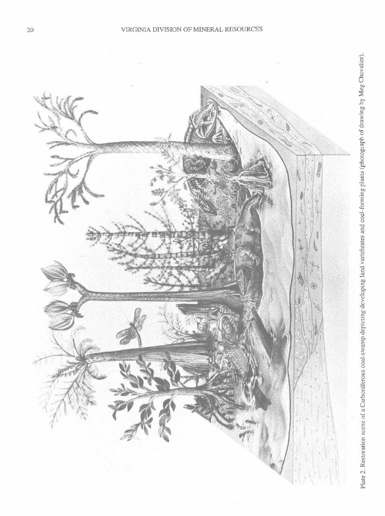
VIRGINIA DIVISION OF MINERAL RESOURCES20
Lc)
oUoo0.)
>loo
-
bI)Y
a
oo
.Y
()
oc)
I
F0.)
b0
(.)
ob0
()
0)
q
(.)o
,q)
O
C)
oC)q
Vq
e.l(.)
,:
;i .i

PUBLICATION 149
Plate 3. Some coal-age fossils (photographs courtesy of the Smithsonian Institution). Figure 1. Landsnail from the Illinois coal measures. Figures 2 and3. Side and front views of Eryops, an advancedamphibian from the Permian of West Texas; speciman about 6 feet long. Figure 4. Stump and rootsof a coal-age lycopod, Lepidodendron; the stump is about 3 feet in diameter. Figure 5. Split concretionwith pressed remnents of leaf whorls of Calamites, a horse tail (Mazon Creek, IL). Figure 6. Bothhalves of a split concretion showing the remains of a leaf of the seed fern Ne uropteris (Mazon Creek,L).
2l
wfri\x i tir t

PUBLICATION I49
Plate 3. Some coal-age fossils (photographs courtesy of the Smithsonian Institution). Figure 1. Landsnail from the Illinois coal measures. Figures 2 and3. Side and front views of Eryops, an advancedamphibian from the Permian of West Texas; speciman about 6 feet long. Figure 4. Stump and rootsof a coal-age I ycopod, Lepidodendroni the stump is about 3 feet in diameter. Figure 5. Split concretionwith pressed remnents of leaf whorls of Calamites, a horse tail (Mazon Creek, IL). Figure 6. Bothhalves of a split concretion showing the remains of a leaf of the seed fern Neuropteris (Mazon Creek,L).
21
til?et x *

22 VIRGINIA DIVISION OF MINERAL RESOURCES
Plate 4. Coal-age plant fossils (photographs courtesy of the Smithsonian Institution). Figure 1. Close-upviewofthe"snakeskin"barkof Sigllarls,alycopodorscaletree. Figlure2.Lepidodendron,anotherscale tree, showing a criss-cross pattern in the bark of a part of a limb about 3 feet long. Figure 3.Carbonized remains of a specimen of Calamites with leaf whorls detached from stalk.
\ttl

22 VIRGINIA DIVISION OF MINERAL RESOURCES
Plate 4. Coal-age plant fossils (photographs courtesy of the Smithsonian Institution). Figure I . Close-upviewofthe"snakeskin"barkof Sigllarls,alycopodorscaletree. Figure2. kpidodendron,anotherscale tree, showing a criss-cross pattern in the bark of a part of a limb about 3 feet long. Figure 3.
Carbonized remains of a specimen of Calamites with leaf whorls detached from stalk.

23PUBLICATION I49
AHc)
q)
o0c)
oo
3k
koo
a9.1
ac.)
o.F
()bo
oq)€
I
c.)
,9)
U
(.)
(.)()
lr)
t-:'\_

23PUBLICATION I49
HC)
q.)
Oot)c)
oo
'k€
GLbo
aa
a0.)
C).F
oo0
oo
0)a
H,a
k
O
()C)Q
(.)
lr)c)
!
.w.,"''{Ii,'*..

VIRGINIA DIVISION OF MINERAL RESOURCES24
I
>r..5ol!) .=gaac!.) -()F
AE
ooaH€-.EYLfv)
3'€2or: >r
'E 1l
_e3=o
R99-q
cdoaq)H>6O
-()Efi.o )lIT^=138
EF
:>':1 a
!*s
>:z.!OA
Prac:(Afr;,,
Et,9'^ux9Uo*C,()a7
Frtr(.) ,d()t>
aoo:AaXY6?.65'5 >,
9.d@xtv=\oPJIZ':,'e"
w
-F
tu,,Iq

VIRGINIA DryISION OF MINERAL RESOURCES24
9a>,..5ot9.=60
'EC)H(DFlr=
OE
o0@lrE6e
9trtu)
2o;t >\-cqo.E
= (.)
oo0R9OE
cdaaaE>(s()
L(J9-cuao().o )lL]
^={o)
EF
E-EE.iG
35x6)i;.sOA
9i1 c.lo.ED9
k'6ox(,)Y
oaoc)q=
F,Fo..t >
LOo!Fa
3R=Y'5 >l
9!ja^o,9*=\ORovJJZ