VIRGINIA^ NORTH CAROLINA - ancestraltrackers.net · —NorthCarolinaStateLine 10-11 ......
16
VIRGINIA^ NORTH CAROLINA
-
Upload
truongtram -
Category
Documents
-
view
213 -
download
0
Transcript of VIRGINIA^ NORTH CAROLINA - ancestraltrackers.net · —NorthCarolinaStateLine 10-11 ......
VIRGINIA^ NORTH CAROLINA
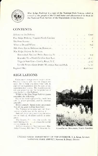
Blue Ridge Parkway is a unit of the National Park System, which is
owned by the people of the United States and administered for them by
the National Park Service of the Department of the Interior.
CONTENTSA Scene on the Parkwav Cwer
Blue Radge Parkwav, Virginia-North Carolina 3
The Four Seasons 4
What to Do and Where 5-6
Mile Posts. Special Information. Entrances 7
Blue Ridge Parkwav bv Sections:
Shenandoah National Park—Roanoke. Va 8-9
Roanoke. Va.— North Carolina State Line 10-11
Virginia State Line— Linville River, N. C. 12-13
Linville River— Great Smokv Mountains National Park 14-15
Regional Map Back Cofer
REGULATIONSEnforcement ot regulations is a part ot the
Parkway rangers' job. but the rangers are
eager also to help you enjoy your visit. Acopy of the regulations may be seen in the
superintendents office. The regulations are
for your protection and for the protection of
your properrv—The Parkway.
while on the Blue Ridge Parkway please
remember the following;
Fire is the forest's greatest toe; build fires
only in places provided, and be cautious
generally.
Drive carefully. Speed zones are posted.
Not all the guard rail has been built.
The Parkway is tor passenger cars. Com-mercial vehicles may not be used on it.
Park only in parking areas along the way—not on Parkway shoulders unless in emer-
gency.
The flowers, r'- - ^n-ic. the woods, the
land, belong to e .....e, please be careful
rot to damage th n.
Address inquiries to; Superintendent. Blue
Ridge Patkway. P.O. Box l-fO. Roanoke.Va. Grandfather Mountain, North Carolina.
UNITED STATES DEPARTMENT OF THE I.XTERIOR. J. A. Krug. 5efre/arv
NATIONAL PARK SERVICE. Newton B, Drurv, Director
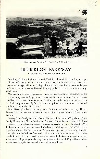
Fox Hunters Paradise Overlook, North Carolina.
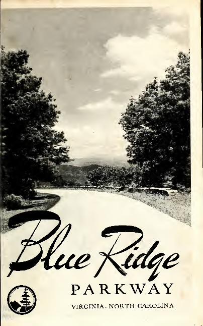
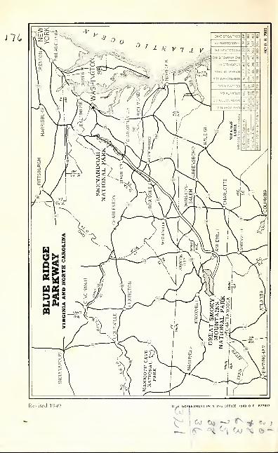
BLUE RIDGE PARKWAYVIRGINIA-NORTH CAROLINA
Blue Ridge Parkwiv, high road through Virginia and North Carolina, designed espe-
cially tor the leisurely tourist, represents a new conception in roads. It is not an express
parkway of the type built about the big cities, but a quiet way through a distinctive part
of the American scene— a road intended for gypsy-like travel on the ride-awhile, stop-
awhile basis.
You travel the Southern Highlands, a land of forested mountains, exquisite during the
flower of spring, cool in the green summer, colorful m the red autumn. The stretches of
woodland, the clustered mountains, and the views out to the lowlands are enlivened by
the fields and pastures of highland farms, where split rail fences, weathered cabins, and
gray barns compose the "hill culture."
Not all is completed of this scenic parkway, the first of its kind to be developed bv the
Nation; but long portions are paved and were enjoyed bv more than a million visitors
last year.
Among the national parks in the East are Shenandoah, in northern Virgmia. and Great
Smoky Mountains, in North Carolina and Tennessee. One of the punjoses of the Parkway
is to connect these wilderness areas over a mountainous distance in i.. 'ly 500 miles. The
Parkway, about two-thirds completed, leads through an "elongated park" which protects
a roadside of varied highland character. The roadway slopes are naturalistically planted in
many places with rhododendron, azalea, white pine, and other native species. Parking
overlooks to the side are convenient balconies. Along the Parkwav at intervals are recrea-
tional areas with picnic grounds, campgrounds, trailer sites, and hiking trails which lead
to exhibits of unspoiled nature and to spots ot native folk lore.
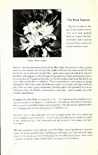
The Four Seasons
The four seasons are defi-
nite in the southern moun-
tains, each with qualities
which set it apart. The Park-
way motor road is open the
year round, but is not recom-
mended tor winter travel.
Native Flame Azalea.
Spring is the favorite season ot many in the Blue Ridge, tor nowhere is there a greater
show ot native flowers. In mid-April the shadblow blooms, lacy white on the hillside;
but the real procession starts in early May,—pink azalea, dogwood, redbud. In mid-Mav
the tlame azalea appears like fire through the undergrowth. Purple rhododendron, native
of certain areas in Virginia and prevalent in North Carolina south from The Bluffs, are
next to bloom (late May to mid-June). The mountain-laurel is everywhere and breaks
during June. The white to pink rhododendron comes later in June and lingers well into
July. There are many spring and summer blooming shrubs and ground flowers in the
wild places along the Parkway. Among these is the galax,—glory ground cover of the
Southern Appalachians.
Sl.MMER in the Blue Ridge is a refuge from the rm temperatures, the altitude account-
ing for as much as five degrees of coolness per thousand feet. The eastern mountains,
forest covered, are notable for their summer greenery. The intermittent highland valleys
are a changmg color pattern of growing corn, buckwheat, rye.
AlTUMN comes to the highlands !..ter than you might think. The sumac, gums, the
tamous southern sourwood, turn b..ii.ant red early in October, but are usually not joined
hv the colorful display of the hardwoods until the last part of the month, even early
November.
Winter sometimes comes suddenly to the Blue Ridge. Travel then becomes uncertam
at best. Ice storms, persistent fogs, and blustery winds make it so. There are many times
when the mountains are clear and beautiful, but we advise local inquiry about travel
conditions during the winter months before venturing on to the Parkway.
What to Do and Where
Motoring.—Blue Ridge Parkway is meanc to serve this American pleasure. In the course
ot a motor trip along the Parkway, plans should include a stop at one of the several
recreational areas for a picnic lunch. Here comfort stations and drinking water will be
found from April 15 until the first freeze, usually mid-October. In these areas we suggest
a leg stretcher along an easy trail, or there are short trails leading from many of the
parking overlooks to selected vantage points.
Picnicking.— Picnic areas, ideal tor the family group, include parking spaces, tables, fire-
places, drinking water, and refuse cans. These areas are designated on the maps bv the
Parkway emblem.
Tourist Facilities.—Gas stations ate being constructed at Rocky Knob, The Bluffs, and
Ctabtree Meadows. The one at The Bluffs will be teady during the 1949 travel season.
Others are located within a short distance ot the Parkway on the more important State
highways.
At Cumberland Knob, Mile Post 219, there is a sandwich shop operated during the
travel season by National Park Concessions, Inc. This company will also opetate the
coffee shop and lodge being built at The Bluffs, but these facilities may not be available
until well into the 1949 ttavel season.
At the Peaks of Otter, Mile Post 86, a sightseeing bus service is offered by the Peaks
of Otter, Inc., from the Parkway to the top of Sharp Top, one of the famous twin Peaks
of Ottet. Sandwiches, soups, and other like items are sold at the bus station during
season.
Tourist facilities along the Patkway are being planned only where accommodations are
not reasonably convenient in the towns and cities nearby. For information about accom-
modations and points of intetest in the Blue Ridge Parkway vicinity, write to the Virginia
State Chamber of Commerce, Richmond 19, Va., or the State News Bureau, Raleigh, N. C.
Camping. — At Rockv Knob in Virginia and The Bluffs in North Carolina are trailer
sites and campgrounds. There vou wi'' find tent platforms, fireplaces, garbage receptacles.
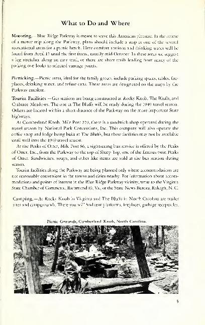
Picnic Grounds, Cumberland Knob, North Carolina.
" '^' ***>- 'S^ Hi
•^
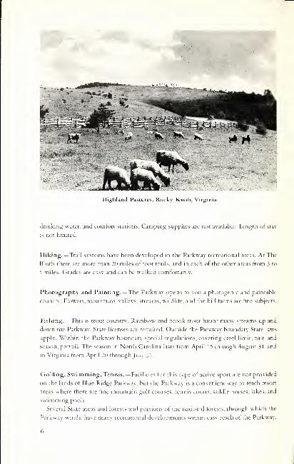
Highland Pastures, Rocky Knob, Virginia.
drinkint; water, and comfort stations. Camping supplies arc not available. Length of stay
IS not limited.
Hiking.— Trail systems have been developed in the Parkway recreational areas. At The
Bluffs there are more than 20 miles of toot trails, and in each of the other areas f-rom 3 to
") miles. Grades are easy and can be walked comfortably.
Photography and Painting.— The Parkway opens to vou a photogenic and paintable
country. Flowers, mountains, valleys, streams, wildlife, and the hill farms are fine subjects.
Fishing. — This is trout country. Rainbow and brook trour haunt many streams up and
down the Parkway. State licenses a/e eauired. Outside the Parkway boundary State laws
apply. Within the Parkway boundary special regulations, covering creel limit, bait, and
sea.son, prevail. The season in North Carolina lasts from April n through August 31. and
in Virginia from April 20 through |u., _.l.
Golfing, Swimming, Tennis.— Facilities tor this type of active sport are not provided
on the lands ot Blue Ridge Parkway, but the Parkwav is a convenient way to reach resort
areas where there are fine mountain golf courses, tennis courts, saddle horses, lakes, and
swimming pools.
Several State areas and forests and portions of the national forests, through which the
Parkwav winds, have many recreational developments within easv reach ot the Parkway.
The Mile Posts
Akm^ paved sections of tlic Parkway you will observe num-
bered mile posts. Zero marker is at Rockfish Gap just south of
Shenandoah National Park, and each mile is numbered pro-
gressively southwestward on the Parkway. Thus each Parkway
mile is identified by a specific number.
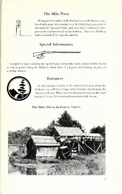
Special Information
Interpretive signs carrving the squirrel gun and powder horn symbol will be found
at various points along the Parkway where there is a legend, old building, or place of
scientific interest.
Entrances
At the entrance to each of the recreational areas along the
Parkway you will find a large carved wooden sign bearing the
Parkway emblem. This is also the designation used on the maps
herein to locate the recreational areas now read\' for use.
Elias Mabry Mill on the Parkway, Virginia.
BLLE RIDGE PARKWAY
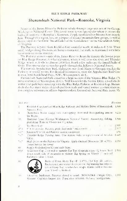
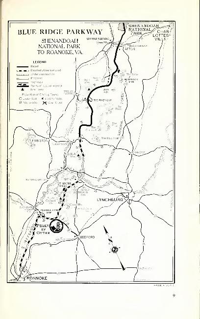
Shenandoah National Park—Roanoke, Virginia
North lit' the James River the Parkway winds through large sections of the George
Washington National Forest. This scenic route is very spectacular where it crosses the
high cliff sections of Humpback Mountain. Purple rhododendron blooms here in early
June. Through this region, too, are glimpses of isolated mountain farm groups, as well as
distant views to the fertile "bread basket of the Confederacy'" in the Shenandoah Valley
of Virginia.
The Parkway is paved from Rockfish Gap south for nearly 46 miles to U S 60. Three
small bridges along this route are being constructed, but traffic is maintained with little
inLonvenience to the traveler.
The Parkway section south ot the James River to Roanoke features the lowest point
on Blue Ridge Parkway, 6"^0 feet elevation, where it will cross the river, and Thunder
Ridge, where it climbs to almost 4,000 feet. South a few miles are the tamed Peaks of
Otter. This spectacular section lies partly through the Jefferson National Forest.
The famous Appalachian Trail, making its way from Maine to Georgia, touches the
Parkway at several points. For detailed information, write the Appalachian Trail Con-
ference. 1916 Sunderland Place, NW., Washington 6. D. C.
Shenandoah National Park conserves a large section of the Virginia Blue Ridge ("'4
miles southwest ot Washington, D. C). Well known tor the St\line Drive, a road wholly
within that park but connecting with the Blue Ridge Parkway at Rockfish Gap, Shenan-
doah also has many miles ot developed toot trails and varied tourist accommodations.
For complete information, address Superintendent, Shenandoah National Park. Luray, Va.
Mi/c Post Elevation
Rockfish Gap-junction Blue Ridge Parkway and Skyline Drive ot Shenandoah 1.909
National Park.
6 Humpback Rocks, craggy rock outcropping. Foot trail from parking area to 3.210
the Rocks.
15 Sherando Lake ( George Washington National Forest). Swimming, fishing. 1.500
picnicking. Turn on VA—814 tor 3 ''2 rniles.
2- Tye River Gap --969
45.6 US 60 crossing. Parkway grade dead-ends ^ miles south 2.312
63." Junction U S 501 and Parkway section southward 6^0
"4." Thunder Ridge Parking Area. One minute walk to superb view ot Arnolds 3.485
Valley.
"6." High point on the Parkway in Virginia. Apple Orchard Mountain (El. 4.229). 3.950
Forest Service fire tower.
80 Purple rhododendron blooms early lune.
83.8 Wilkinson Gap. Foot trail to summit Flat Top Mountain takes 1 ?4 hours. Trail 2.511
down south side of mountain to vicinirv' Big Spring on VA—13 ( 1 mile oft
Parkway) takes 1 hour.
86 /^^^^ P'^-i'^^ ot" Otter. Sharp Top (El. 3.8"5l. Flat Top (El. 4.001).
Recreational area under development. Sightseeing bus trips to
top ot Sharp Top; sandwiches, soups, drinks, sold at bus sta-
tion. \'A—13 to Bedford.
90 \'.\-4.^ CO Buchanan, Parkway closed to south. ROANOKE (Magic Cit>). 1.000
Western \'irginia s largest cin-. Population 100.000. Parkway headquarters.
PKY B R 7005 1
BLUK RIDGK PARKWAY
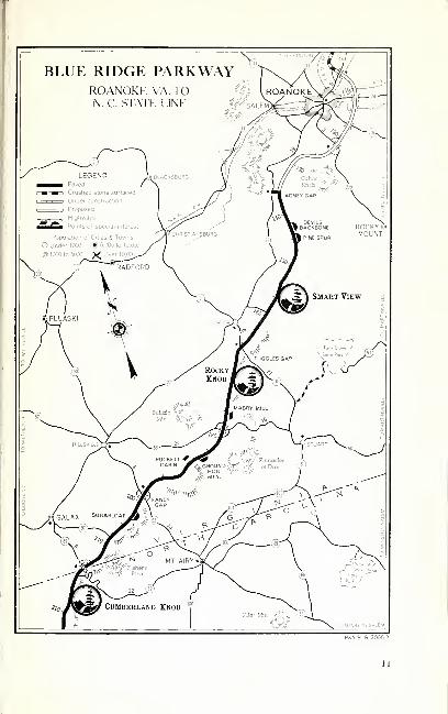
Roanoke, Va.—North Carolina State Line
From AJncv Gap ( \9 miles south ot Ro.inokc bv way ot U S 221 ) the Parkwav is paved
south to tlie State Line and beyond to Deep Gap near Boone and Blowing Rock. This
section of Parkway through lower Virginia is notable for its pictures of mountain farm-
ing. The Blue Ridge here is a high rolling plateau which breaks in a sharp escarpment
toward the east and the lower Piedmont. The Parkway generally follows the crest, which
IS the water divide between Atlantic and Gulf drainage, affording occasional fine views
over the low country. In other places the Parkway recedes into wooded and pastoral
vallcNS ot c]uiet charm.
Wi/t' Prist Elevation
\\b Adney Gap. Terminus 140 mile paved section to Deep Gap, N. C 2,690
1-14 Devil's Backbone- Parkint; Overlook. Fine view over (arming region 2,685
144.8 Pine Spur Parking Overlook. Named tor the white pine which is the tree 2,703
depicted on Parkway emblem.
1°>0 .Magnificent riame azalea, blooms mid-Mav.
154.5 .rf^^^lv Smart View, 500 acres, hiking trails, large picnic grounds, com- 2,500
tort stations, drinking water. The cabin home of T T. Trail,
immediately adjacent entrance road, is picturesque. Rim trail in
this area is part of Appalachian Trail system. Smart View is
center ot Parkway's dogwood bloom in early May.
164 Fine .izalca ^how, Also niountaindaurel in Kite .May.
165.2 Tuggles Gap. VA-8. turn-oti' tor Fairy Stone State Park 16 miles. Swimming. 2,^52
boating, picnicking.
16" Rocky Knob, 4,000 acres. Picnicking, camping, trailer sites, 3.225
hiking, comfort stations, drinking water, fishing 5 miles ot Rock
Castle Creek. Foot trail from Saddle Parking Overlook (Mile
168) to summit of Rocky Knob (El. 3.5^0) takes 10 minutes,
continues along rim to Grassy Knoll (Mile 1"0) Fine for
flame azalea late in May.
1"6.1 .M.ibry Mill, grist and sawmill, wheelwright and blacksmith shops, illustrating 2.85'i
typical mountain industrial plant, fascinating and ingenious. Buildings will
later be opened for inspection.
17". ~ Meadows ot Dan. LI S 58 longest east-west road across Virginia. Inquire locally 2,964
about Lovers Leap and the Pinnacles ot Dan.
189.2 Groundhog Mountain Parking Overlook, high point aftording 360^ view. 3.030
Observation tower, simulating old tobacco barn. Examples ot various types ot
old chestnut rail fences, such as snake, post and rail, and buck.
189.9 Puckett Cabin, home of Arlena Hawks Puckett, storied midwife of the local hills. 2,850
M9.^ Fancy Gap. L' S 5 2. where local products, such as cabbage, are gathered to be 2.920
trucked down the mountains.
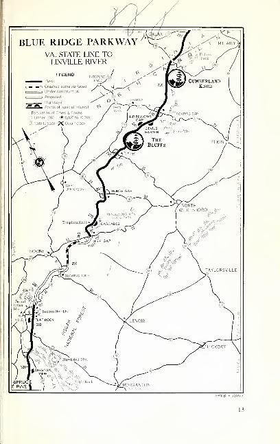
BLUE RIDGE PARKWAY
Virginia State Line— Linville River
The noitherU' 60 miles sliown finished on the map facing this page. Hke the section
north toward Roanoi<:e, thread a country remarkable for its mountain fields and pastures;
but the country is more rugged, the Blue Ridge becoming more defined and higher. It is
completed as to landscaping between the State Line and The Blufifs. A sandwich shop is
open at Cumberland Knob.
Sixtv miles of Parkway are available southward from Linville. From Deep Gap, near
Boone, it is nor tar to Blowing Rock and Linville. resort towns at the edge of Grand-
father Mountain. This "patriarch." elevation 5,939 feet, is one of the oldest, shaggiest
mountains of the Appalachians. The road across Grandfather. U S 221, is known as the
Black Bear Trail ( Yonahlossee in the language of the Cherokee).
North Carolina-Virginia State Line 2,547
Cumberland Knob. 1,000 acres, sandwich shop (sandwiches. 2. "'40
drinks, soups, picnic box lunches), picnic area, comfort stations,
drinking water. 15-minute loop trail to Cumberland Knob (El.
2.855). Loop trail into Gully Creek Gorge. 2 hours.
Fox Hunters Paradise Overlook and Parking Area. 10 minutes by trail to the 2.805
Paradise, where old-time hunters listened to their hounds.
219 Fine display of pink azalea; blooms early May. Flame azalea blooms mid-May.
228 Fine beds ot pink azalea; blooms early May. This section also tine tor mountain-
laurel in early June.
The Blurts, 6.000 acres— picnic grounds (Mile 241). camp- 3. "10
grounds (Mile 239). trailer sites, comfort stations, drinking
water. 20 miles of trail. This area atifords fine examples ot blue-
grass downs, terminating in precipitous bluffs. Purple rhodo-
dendron in meadows and on trails late May. At Mile 238.5 is
the picturesque Carolyn Brinegar Cabin. Be sure to visit Wildcat Rocks (Mile
241.1 ). from which you may look down 1.500 feet upon what was once the
homestead of the Caudill family, dram,, c exhibit of isolated mountain life.
lO-minute trail to Fodderstack Mounts .n. Gas station and coffee shop open.
2" 1.9 Cascades Parking Overlook. Woodland trail along a mountain stream to cascades 3.5"0
tumbling several hundred teet. Delightful 8-minute walk.
2"6.5 Deep Gap. Between Deep Gap and Beacon Heights there are good connecting 3.140
paved roads. The Parkway between Mile Posts 282 and 292 will be paved dur-
ing 1949.
304.9 Beacon Heights. Make inquiry at Linville or Blowing Rock for entrance to Daniel 3-140
Boone Boy Scout Trail over the seven peaks ot Grandfather Mountain tor which
the larger part ot a day must be allowed.
308.2 Flat Rock Parking Area. 10-minute trail to supetb prospect of Linville Valley and 3.995
Grandfather Mountain. Easy climb and most worth while.
.^16.4 Linville River Parking Area. Here is one of the Parkway s largest stone arch 3.250
bridges, three spans of 80 feet each. Fishing in Linville River under State laws.
BLUE RIDGE PARKWAY
339.5
36
40
468
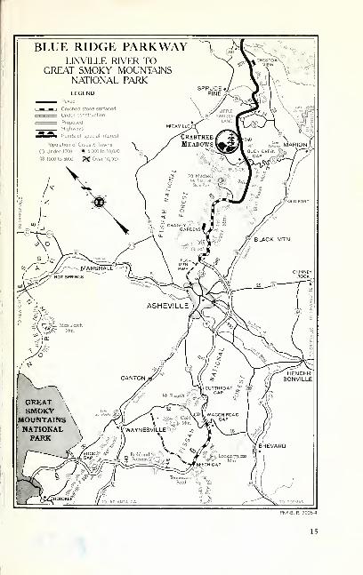
Linville River— Great Smoky Mountains National Park
The Piirkway between Linville Falls and Asheville traverses one of the great mountainsections ot North Carolina where the Blue Ridge, the Blacks, and the Craggy Mountainsmerge. Mount Mitchell. 6.6&4 feet in elevation, and the highest peak in the East, is prom-inent from the Parkway. The large holdings of the iMitchell Division of the Forest Ser\-ice
and the Asheville Watershed have protected the area from despoliation.
Milt Post Eleiation
320." Chesto.i \'iew offers an unusually fine view trom one of the many vertical cliffs 4.110
on Humpback Mountain.
Crabtree Meadows. 160 acres lying within the Pisgah National 3. "35
Forest and now partially developed. Hiking, picnicking, and
comfort stations available. The 40-minute walk to Crabtree
Falls is not to be missed.
355.4 Swannanoa Gap, Mount Mitchell State Park. 4.8 miles on spur road. South to 5,185
Mile Post 36^.5 the Parkway is under contract to be completed early in summer
of 1949 when this spectacular section will be opened to traffic. Make local in-
quiry. Paving of the Parkway through the Craggy Mountains is scheduled for
1950, and over the crushed stone surface special care in driving should be
exercised.
Bee Tree Gap. turn off for Craggy Rhododendron Gardens. Forest Senice devel- 4. "69
opment. The peak of the rhododendron bloom is in mid-June. Make inquiries in
Asheville for highway connection to Parkway from the city. ASHEVILLE. a
leading city in the South. Population. 50,000.
Mount Pisgah, The Forest Service Pisgah motor road. Cutthroat Ga^ to WagonRoad Gap, is still open, and 5 miles ot Parkway, graded with loose gravel, extend
beyond Wagon Road Gap and are available for a "preview."
The Great Smoky Mountains National Park, where the Parkway will one day
terminate, is located equally in North Carolina and Tennessee. Its 460.000 acres
ot mountainous wilds may be viewed trom paved roads and many wilderness
trails. Tourist accommodations are in nearby towns. Inquire Superintendent,
Cireat Smok\' Mountains National Park. Gatlinburg. Tenn.
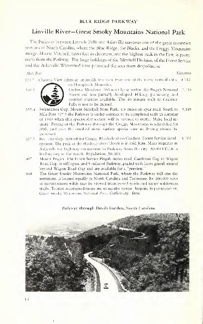
Parkway through Devils Garden, North Caroli
14
15
otHOsnai^moD 1 i s g
vd oangsiaavH fi s 3 g
V Vd HSynsSilid g s S §
ONI SnOdVNVIQNI K ? 3 5
f-M 3niASinoi S g S 8
—
>
NN3i3ni/\HSVN £ 1 § 3
"iv wvHSNiwaia s 1 ^ §
"DS viswmoD g ,- s "
VV9 VlNVliV s *'-='!
V "^Q NOiSMfWSVW ^^-1AN -UdOA W3N ii
4r
y III
^ z
5 ; z 1
"/
^-I
cv 0* --? 1^ -^ c^ I— 15^ ^ ^ 00 ^ o ^
![The Torch [1954] - ancestraltrackers.net · "Dedication Asatokenofourappreciationfortheirloyalty,devotion,andenduring guardianship,we,theSeniorsof1954,dedicatethiseditionof"TheTorch"](https://static.fdocuments.in/doc/165x107/5b4309427f8b9a14058ba63b/the-torch-1954-dedication-asatokenofourappreciationfortheirloyaltydevotionandenduring.jpg)