PBT Fencing – Professional fencing sport equipment made in ...
Draft Tiered Site-Specific Environmental Assessment
Viola Rail Interchange Yard Fencing Corpus Christi, Texas Port Security Grant Program Project #s’ 2011‐PU‐K00178 (09) (11315)
October 2012 Federal Emergency Management Agency Department of Homeland Security 500 C Street, SW Washington, DC 20472

1 | P a g e
I. Background In accordance with 44 Code of Federal Regulations (CFR) for the Federal Emergency Management Agency (FEMA), Subpart B, Agency Implementing Procedures, Part 10.9, a Programmatic Environmental Assessment (PEA) for Grant Programs Directorate Programs was prepared and a Finding of No Significant Impacts (FONSI) was issued in July 2010 (Appendix B), pursuant to Section 102 of the National Environmental Policy Act (NEPA) of 1969, as implemented by the regulations promulgated by the President’s Council on Environmental Quality (CEQ; 40 CFR Parts 1500-1508). This Tiered Site-Specific Environmental Assessment (SEA) is being prepared in accordance the July 2010 PEA. The focus of this Tiered SEA is on those areas of concern requiring additional discussion or analysis that are beyond the scope of the PEA. The proposed Viola Rail Interchange Yard Fencing site is located in the Port of Corpus Christi, Texas. The site is located in the maintained intermodal right of way between a spur of the Missouri Pacific railroad line and Carbon Plant Road (County Road 55B). The adjacent land is disturbed by commercial shipping activities and interspersed with open shrub/scrub vegetation (Appendix A). II. Purpose and Need The Port of Corpus Christi has applied for Port Security Grant Program funding under application numbers 2011-PU-K00178 (09) (11315). The purpose of this program is to provide for activities which help to enhance the security and safety of ports in the United States. The Port of Corpus Christi has indicated there are no intruder deterrence devices in a remote area at the end of the inner harbor. This area, which will be the future site of the Viola Rail Interchange Yard, is used by the military and commercial ships containing hazardous cargo. There is a need for access control to limit entry into this area to only those persons with the appropriate security clearance. III. Alternatives Two project alternatives are proposed in this SEA: 1) No Action and 2) Proposed Action Alternative- Viola Rail Interchange Yard Fencing at the Port of Corpus Christi. Under the No Action Alternative, no changes would be made to the existing site. As a result of this alternative, the inner harbor would continue to lack appropriate protection in an area with security concerns. Under the Proposed Action Alternative, the Port of Corpus Christi proposes to enhance the protection of maritime resources, by installing 8,000 linear feet of fencing to prevent and deter intruders from entering the future rail yard. The fence will be installed between the rail yard and a public intermodal roadway.

2 | P a g e
The proposed fence would be 8 feet tall with a barbed outrigger at the top and will be installed adjacent to the railroad ballast. Poles will be installed 10 feet apart and 4 feet deep. A 1-foot wide fence curb would anchor the bottom of the fence to prevent lifting of the fence fabric. The fence curb would provide a barrier to deter digging under the fence. The proposed Viola Rail Interchange Yard Fencing is located at the Port of Corpus Christi, Corpus Christi, Texas 78370 (Appendix A). IV. Environmental Impacts Discussion of the environmental impacts associated with the No Action Alternative is included in the July 2010 PEA. This document incorporates the PEA by reference. The PEA can be found in FEMA’s electronic library at http://www.fema.gov/library/viewRecord.do?id=4143. Environmental impacts are not anticipated to occur as a result of the No Action Alternative. Therefore, only the environmental impacts associated with the Proposed Action Alternative were evaluated in this Environmental Assessment. FEMA’s environmental planning and historic preservation review reveals that all environmental areas of concern are appropriately accounted for in the PEA with the exception of floodplain impacts. Table 1-1 provides a summary of the findings for the environmental areas of concern that FEMA typically reviews. Table 1-1. Summary of Other Environmental Areas of Concern
Area of Concern No Action Alternative Proposed Action Alternative Historic properties No effects. FEMA made the determination of No Historic
Properties Affected by this project.
Endangered and threatened species and critical habitat
No effects. No effects.
Migratory birds No effects. No effects.
Water quality No effects. No effects.
Coastal resources No effects. Based on a review of Coastal Coordination Council General Concurrence #5, FEMA has determined that the Proposed Action Alternative is deemed consistent with the goals and policies of the Texas Coastal Management Program and consistency review procedures as implemented by the Texas General Land Office.
Wetlands No effects. No effects. See National Wetland Inventory Map in Appendix A.
Low-income and minority populations
No effects. Low income and minority populations are near project area. However, the proposed site improvements are anticipated to have beneficial impacts to the community.
In compliance with FEMA regulations implementing Executive Order 11988, Floodplain Management, FEMA is required to carry out the Eight-step decision-making process for actions that are proposed in the floodplain per 44 CFR §9.6. Executive Order 11988 requires federal

3 | P a g e
agencies “to avoid to the extent possible the long and short term adverse impacts associated with the occupancy and modification of the floodplain and to avoid direct or indirect support of floodplain development wherever there is a practicable alternative.” This Eight-step process is applied to the proposed Port of Corpus Christi, Viola Rail Interchange Yard Fencing project. The steps in the decision making process are as follows: Step 1 Determine if the Proposed Action Alternative is located in the Base Floodplain The Proposed Action Alternative involves the construction of a proposed Emergency Response Operations Center. FEMA has determined that the Proposed Action Alternative is located in a 100-year floodplain, Zones A21 and A24 (Areas of 100-year flood; base flood elevations and flood hazard factors determined), as depicted on FIRM Community Panels 4854940284C and 4854940282C, both with the effective date March 18, 1985 (Appendix A). Step 2 Early public notice (Preliminary Notice) A public notice for the proposed Viola Rail Interchange Yard Fencing will be published in the regional newspaper, Corpus Christi Caller-Times, as part of the notice of availability for this SEA. Step 3 Identify and evaluate alternatives to locating in the base floodplain The proposed Viola Rail Interchange Yard Fencing project must take place in the floodplain because the project would be considered as functionally dependent use. Therefore no practicable alternative outside of the floodplain exists that would provide the port community adequate protection of this area. Step 4 Identify impacts of Proposed Action Alternative associated with occupancy or modification of the floodplain Impact on natural function of the floodplain The proposed Viola Rail Interchange Yard Fencing project would not affect the functions and values of the 100-year floodplain nor would it impede or redirect flood flows. The proposed project would be located in a partially developed area with existing infrastructure. When compared to the extensive floodplain area, the proposed Viola Rail Interchange Yard Fencing will little potential to impact the floodplain. Therefore, the Proposed Action should not result in an increased base discharge or increase the flood hazard potential to other structures. Impact of the floodwater on the proposed facilities The proposed Viola Rail Interchange Yard Fencing project has been designed to minimize impacts from flooding. The concrete curb at the bottom of the fence will be installed at the same elevation as the adjacent natural ground and will not block any drainage. Floodwaters will be able to pass through the chain link fence. However, there is a potential that the proposed Viola Rail Interchange Yard Fencing project could be damaged if a catastrophic flooding event were to occur. Step 5 Design or modify the Proposed Action Alternative to minimize threats to life and property and preserve its natural and beneficial floodplain values In order to reduce the impact identified in Step 4 of flood hazards on the proposed new facilities, the proposed Viola Rail Interchange Yard Fencing project will be designed to be compliant with FEMA recommendations for construction in flood hazard areas.

4 | P a g e
The Applicant must follow all applicable local, state, and federal laws, regulations and requirements and obtain and comply with all required permits and approvals, prior to initiating work on this project. No staging of equipment or project activities shall begin until all permits are obtained. Step 6 Re-evaluate the Proposed Action Alternative Per the discussions above, the proposed site will be appropriately designed for the 100-year floodplain. The project would be considered as functional dependent use. The proposed Viola Rail Interchange Yard Fencing project is intended to protect the port and associated commercial and military infrastructure from unauthorized intruders. The Proposed Action Alternative will not aggravate the current flood hazard because the project would not impede or redirect flood flows. The project will not disrupt floodplain values because it will not change water levels in the floodplain. Therefore, it is still practicable to construct the proposed project within the floodplain. Alternatives consisting of locating the project outside the floodplain or taking “no action” are not practicable. Step 7 Findings and Public Explanation (Final Notification) In accordance with 44 CFR §9.12, the Port of Corpus Christi must prepare and provide a final public notice 15 days prior to the start of construction activities. Documentation of the public notices are to be forwarded to FEMA for inclusion in the permanent project files. Step 8 Implement the action The Port of Corpus Christi will incorporate into the design necessary mitigation efforts for building within a 100-year floodplain. As a result of this Eight-step process, FEMA has determined that the Port of Corpus Christi, Multi-Agency Emergency Response Operations Center is in compliance with 44 CFR §9.6 because there are no practicable alternatives outside the 100-year floodplain. V. Mitigation
1. Significant change, addition, and/or supplement to the approved scope of work which alters the existing use and function of the structure, including additional work not funded by FEMA but performed substantially at the same time, will require re-submission of the application prior to construction to FEMA for re-evaluation under the National Environmental Policy Act.
2. The Port of Corpus Christi must comply with all permit conditions and conditions
required by the local floodplain management ordinance for this project. A copy of the permit and documentation of compliance with permit conditions will be forwarded to FEMA for inclusion in the permanent project file.
3. In accordance with 44 CFR §9.12, The Port of Corpus Christi must publish a public
notice 15 days prior to the start of construction activities. Documentation of the public notice is to be forwarded to FEMA for inclusion in the permanent project files.

5 | P a g e
In addition, The Port of Corpus Christi will be required to comply with the conditions that are stated in the PEA FONSI, dated July 7, 2010, for the Proposed Action Alternative (see Appendix B). VI. Correspondence and Agencies Consulted (see Appendix C)
Texas Coastal Coordination Council VII. Public Comment The public was notified of the availability of the Draft SEA through the publication of a public notice on November 8, 2012 in Corpus Christi Caller-Times. The Draft SEA is available for comment and can be viewed and downloaded from FEMA’s website at https://www.fema.gov/environmental-documents-and-public-notices-in-region-vi or the Port of Corpus Christi Authority website at www.portofcorpuschristi.com. A copy of the document can also be viewed at the Port of Corpus Christi Authority located at 222 Power Street, Corpus Christi, TX 78401 Monday through Friday during the hours of 8:00 AM to 5:00 PM. A 15-day public comment period will commence on the initial date of the public notice. FEMA will consider and respond to all public comments in the Final SEA. VIII. List of Preparers Kevin Jaynes, Regional Environmental Officer, FEMA Region VI Alan Hermely, EHP Specialist, FEMA Region VI
Appendix A
Figures and Photographs
This Appendix has been redacted because it contains Sensitive Security Information that is controlled under 49 CFR parts 15 and 1520. No part of this record may be disclosed to
persons without a ‘‘need to know’’, as defined in 49 CFR parts 15 and 1520, except with the written permission of the Administrator of the Transportation Security Administration
or the Secretary of transportation. Unauthorized release may result in civil penalty or other action. For U.S. government agencies, public disclosure is governed by 5 U.S.C. 552
and 49 CFR parts 15 and 1520.”

Appendix B
Finding of No Significant Impact (FONSI)
For
Final Programmatic Environmental Assessment for the Evaluation of FEMA’s Grant Programs
Directorate Programs
U.S. Department of Homeland Security 500 C Street, SW Washington, DC 20472
FEMA
FEDERAL EMERGENCY MANAGEMENT AGENCY (FEMA)
FINDING OF NO SIGNIFICANT IMPACT (FONSI)
FINAL PROGRAMMATIC ENVIRONMENTAL ASSESSMENT FOR THE EVALUATION OF FEMA'S GRANT PROGRAMS
DIRECTORATE PROGRAMS
BACKGROUND
In accordance with the National Environmental Policy Act (NEPA) of 1969, FEMA's regulations for implementing NEP A at 44 Code of Federal Regulations (CFR) Part 10, and the President's Council on Environmental Quality NEPA implementing regulations at 40 CFR Parts 1500-1508, FEMA prepared a draft Programmatic Environmental Assessment (PEA) to evaluate the potential impacts to the human environment resulting from typical actions funded by FEMA's Grant Programs Directorate (GPD) through the homeland security and emergency preparedness grant programs. These programs provide grant funding to States, territories, local and Tribal governments, and private entities to enhance their homeland security and emergency preparedness efforts. The PEA is incorporated by reference into this FONSI.
The PEA is intended for actions that are relatively minor in scale and typically considered for funding under the various GPD programs. The PEA evaluated two alternatives: no action and program implementation. Under the program implementation alternative, FEMA evaluated the following seven project types: planning; management and administration; training; exercises; purchase of mobile and portable equipment; modification of existing structures and facilities; and new construction. FEMA will develop Tiered Site-specific Environmental Assessments (SEA) for those GPD actions requiring evaluation under areas of concern not evaluated in this PEA, having impacts beyond those described in the PEA, requiring mitigation to reduce the level of impacts below significance, or otherwise requiring a Tiered SEA as identified in Table 5-1 in the PEA.
Notice of the availability of the PEA was published in the Federal Register on April 8, 2010, for a 30-day public comment period. Based on comments received, FEMA removed communication towers as a project type evaluated in the PEA. FEMA will develop a separate analysis tiered from this PEA to address communication towers and will provide a IS-day public comment period on that document.
www.fema.gov

GPO PEA FONSI Page 2
CONDITIONS
Actions under this PEA and FONSI must meet the following conditions. Failure to comply with these conditions would make the FONSI determination inapplicable for the project and could jeopardize the receipt of FEMA funding.
1. Excavated soil and waste materials will be managed and disposed of in accordance with applicable local, state, and federal regulations. If contaminated materials are discovered during construction activities, the work will cease until the appropriate procedures and permits are implemented.
2. The grantee and sub grantee will follow applicable mitigation measures as identified in Section 7 of the PEA to the maximum extent possible.
3. In the event that unmarked graves, burials, human remains, or archaeological deposits are uncovered, the grantee and subgrantee will immediately halt construction activities in the vicinity of the discovery, secure the site, and take reasonable measures to avoid or minimize harm to the finds. All archaeological findings will be secured and access to the sensitive area restricted. The grantee and subgrantee will inform FEMA immediately and FEMA will consult with the State Historic Preservation Officer (SHPO) and/or Tribal Historic Preservation Officer (THPO) or appropriate Tribal official. Construction work cannot resume until FEMA completes consultation and appropriate measures have been taken to ensure that the project is in compliance with the National Historic Preservation Act and other applicable Federal and State requirements.
4. The grantee and sub grantee must meet any project-specific conditions developed and agreed upon between FEMA and with environmental planning or historic preservation resource and regulatory agencies during consultation or coordination.
5. The grantee and subgrantee are responsible for obtaining and complying with all required local, State and Federal permits and approvals.
FINDING
Based upon the information contained in the Final PEA, the potential impacts resulting from the seven project types analyzed in the PEA, and in accordance with FEMA's regulations at 44 CFR Part 10 and Executive Orders 11988 (Floodplain Management), 11990 (Protection of Wetlands), and 12898 (Environmental Justice), FEMA finds that the implementation of the proposed action will not have significant impacts to the quality of the human environment. Therefore, an Environmental Impact Statement (EIS) will not be prepared. This FONSI is based upon proposed actions fitting one of the seven project types described in the Final PEA and meeting all conditions prescribed for that particular project type.

GPO PEA FONSI Page 3
Environmental Officer
Grant Programs Directorate
Date _7~/2=----./L......:....-) 0 __ I 7
Date W
Appendix C
Agency Consultation
COASTAL COORDINATION COUNCIL GENERAL CONCURRENCE #5
Regarding Federal Emergency Management Agency (FEMA) assistance to areas of Texas designated as major disaster areas
Pursuant to 31 Texas Administrative Code (TAC) §§506.28 & 506.35 and 15 Code of Federal Regulations (CFR) §930.53(b), the Coastal Coordination Council (Council) issues the following General Concurrence #5 (GC5) for FEMA assistance in federally declared disaster areas.
Section 1: Purpose and Intent
A. The purpose of this GC5 is to assist FEMA by expediting consistency review of certain FEMA-funded activities under the Texas Coastal Management Program (CMP) and to identify the certain activities affecting certain coastal natural resource areas (CNRAs) that must undergo a full consistency determination. The purpose of the GC5 is to minimize the number of consistency reviews that must be performed for activities that are minor in scope and that do not have significant adverse effects on CNRAs within the Texas CMP boundary. The CMP boundary is depicted in Appendix A of this document and is more particularly described in 31 TAC §503.1.
B. FEMA and the Council acknowledge that the implementation of disaster assistance will be more effective if specific procedures are developed to expedite consistency review activities by the Council for activities with little potential to affect CMP Areas. This GC5 should shorten the time needed to comply with the Texas CMP for FEMA-funded projects and allow FEMA to more readily provide assistance following a federally declared disaster on the Texas coast.
C. FEMA and DEM implement the Individual and Public 'grants' under FEMA's Individual and Public Assistance programs, as defined in 44 CFR §206.2(15)&(20). FEMA has determined that the implementation of the programs in 44 CFR Part 206 may have an effect upon properties within the Texas CMP boundary. Therefore, FEMA and the Council agree that these disaster assistance programs shall be administered in accordance with the following Sections, which will ensure compliance under the CMP.
Section 2: Activities Covered'
A. This GC5 is intended to incorporate FEMA's existing process for providing assistance for projects in major disaster areas. FEMA proposes to administer federal programs pursuant to the Robert T. Stafford Disaster Relief and Emergency Assistance Act, 42 U.S.C. 5121-5206 (Stafford Act), and its implementing regulations contained in Title 44 CFR Part 206, regarding assistance for the repair or replacement of damaged facilities and structures,
1
-~~~~~~~- ~---~------ --~-------~-~--------------------
including approved Stafford Act Section 404 and 406 mitigation measures, 42 U.S.C. §§5l70c & 5172.
B. The Council finds that the following assistance activities will not have direct or significant adverse effects on CNRAs and determines that FEMA or its grantees and subgrantees need not submit consistency findings for the following activities within the Texas CMP boundaries:
1. Funding of emergency response activities as provided under Stafford Act Section 403 (42 U.S.C. §5l70b), Category A: Debris Removal and Category B: Emergency Protective Measures that are necessary when there is an unacceptable hazard to life, when there is an immediate threat of significant loss of property, or where an immediate and unforeseen economic hardship is likely if corrective action is not taken within a time period less than the normal time needed under standard procedures in 31 TAC §506.51. This includes activities that are necessary to protect public health and safety, as defined in Emergency 44 CFR §206.2(9), including direct federal assistance, funded by FEMA, such as water, ice, and power generation teams.
2. Individual 'grants' under FEMA's Individual Assistance Program, as defined in 44 CFR § 206.2(15).
3. Repair and construction projects that are covered under Categories C: Roads and Bridges, D: Water Control Facilities, E: Buildings and Equipment, F: Utilities, and G: Parks, Recreational Facilities, and other Items included in Stafford Act Section 403 (42 U.S.C. §5l70b), and that have the same function, capacity, and footprint as existed prior to the major disaster, including upgrades to current codes and standards, provided that all three conditions are met. These projects are only exempt from the consistency requirements if they do not fall within the CNRAs listed in subsection "C" below. Even if all three conditions are met, a project may require a consistency determination, as outlined in subsection "C" below.
4. Repair or replacement of automobiles and equipment. 5. Repairs and construction inside or outside of structures in the same
footprint, even if the repairs have a different function and capacity than previously existed; and which may occur in previously disturbed areas around the exterior ofthe structure.
6. Reconstruction of Coastal Historic Areas. A historic area is defined as a site that is specially identified in rules adopted by the Texas Historical Commission as being coastal in character and that is: (A) a site on or eligible for the National Register of Historic Places, designated under 16 USC §470a and 36 CFR, Part 63, Chapter 1: or (B) a state archaeological landmark, as defined by Texas Natural Resource Code (TNRC) , Subchapter D, Ch. 191. These are governed by the Programmatic Agreement Among the Federal Emergency Management Agency, the Texas State Historic Preservation Office, the Texas Department of Public
2
'/J

----------- ----~--- ----
Safety, Division of Emergency Management, and the Advisory Council on Historic Preservation (P A) or any subsequent replacement documents. Compliance with the PA satisfies the requirements of31 TAC §501.14(0), and no separate consistency review is required.
C. Consistency determinations are required for activities over which the Council has jurisdiction, if they occur in certain CNRA areas within the CMP boundary, even if the project has the same function, capacity, and footprint as existed prior to the maj or disaster. FEMA may fund a necessary emergency response activity within a CNRA without a consistency determination when the emergency response activity was performed to prevent an unacceptable hazard to life, an immediate threat of significant loss of property, or where an immediate and unforeseen economic hardship is likely if corrective action were not taken within a time period less than the normal time needed under standard procedures in 31 TAC §506.51. Maps and information on all of the CNRA areas below may be found on the General Land Office's web site at http://www.glo.state.tx.us/gisdataJ gisdata.html. FEMA must provide consistency determinations for projects that fall within the 'following CNRA areas.
1. Critical Areas. These are defined in TNRC §33.203(8) and 31 TAC §501.3(a)(8) as a coastal wetland, oyster reef, hard substrate reef, submerged aquatic vegetation, or tidal sand or mud flat. Each of these critical areas is more specifically described under 31 TAC §501.3(b) (See Appendix B). Dredging and construction of structures in, or the discharge of dredged or fill material into critical areas must comply with the policies in 31 TAC §501.l4(h).
2. Submerged Lands "Submerged land" means land located under waters under tidal influence or under waters of the open Gulf of Mexico, without regard to whether the land is owned by the state or a person other than the state. TNRC §33.203(15) and 31 TAC §501.3(b)(12). Development on submerged lands must comply with the policies in 31-TAC §501.14(i).
3. Beach/Dune System and Critical Dune Areas. "Critical dune area" is defined as a protected sand dune complex on the Gulf shoreline within 1,000 feet of Mean High Tide in TNRC §33.203(9) and 31 TAC §501.3(b)(6). Construction in critical dune areas and adjacent to Gulf beaches must comply with the policies in 31 TAC §501.14(k).
4. Coastal Hazard Areas. These are defined in 31 TAC §501.3(a)(4) as special hazard areas and critical erosion areas. Definitions of special hazard areas and critical erosion areas may be found in Appendix C. Goals and policies for determining the consistency of development in coastal hazard areas are found in 31 TAC §501.14(l).
5. Coastal Barriers. These are defined in TNRC §33.203(2) and 31 TAC §501.3(b)(1) as an undeveloped area on a barrier island, peninsula, or other protected area, as designated by United States Fish and Wildlife Service maps. Development of new infrastructure or major repair of
3

existing infrastructure within or supporting development within Coastal Barrier Resource System Units and Otherwise Protected Areas designated on maps dated October 24, 1990, under the Coastal Barrier Resources Act, 16 United States Code Annotated, §3503(a), must comply with the policies in 31 TAC §501.14(m).
6. State Parks, Wildlife Management Areas or Preserves. "Coastal preserve" is defined in 31 TAC §501.3(b)(3) as any land, including a park or wildlife management area, that is owned by the state and that is subj ect to Chapter 26, Parks and Wildlife Code, because it is a park, recreation area, scientific area, wildlife refuge, or historic site; and designated by the Texas Parks and Wildlife Commission as being coastal in character. Under 31 TAC §501.14(n), development by a person other than the Parks and Wildlife Department that requires the use or taking of any public land in such areas must comply with Texas Parks and Wildlife Code, Chapter 26.
7. Coastal shore areas, defined in TNRC §33.203(5) as an area within 100 feet landward of the highwater mark on submerged land.
8. Water under tidal influence, defined in TNRC §33.203(19) as water in this state, as defined by Section 26.001(5), Water Code, that is subject to tidal influence according to the Texas Commission on Environmental Quality's (formerly the Texas Natural Resource Conservation Commission's) stream segment map. The term includes coastal wetlands. The Council shall provide FEMA a detailed map indicating these areas influenced by tidal waters.
Section 3: Notification Procedures
For those proposed activities that will be reviewed for consistency with the CMP under the Council's rules (31 TAC §§506.50-506.52), FEMA shall submit to the Council Secretary FEMA's project worksheet, proposed work, and the name, address and telephone number for a point of contact. A description of the project must include at least the application, and location map, and supporting material required by FEMA, as well as the information required by Council rules at 31 TAC §506.50(c), which includes a brief evaluation on the relationship of the proposed activity to the CMP goals and policies and an evaluation of any reasonably foreseeable coastal effects. Under 31 TAC §506.51(d), if three members do not refer an application to the Council within 30 days of the date the Council Secretary receives a copy of the application, then the application is conclusively presumed to be consistent with the CMP.
Section 4: Interagency Coordination Procedures
The Council will work with FEMA and DEM in scoping meetings to identify CMP concerns and CMP applicability to FEMA activities following a federally declared disaster. FEMA and the Council may adopt amendments to this GC5 based on the scope of an individual disaster.
4

Section 5: Termination
A. The Council may modify this GC5 by issuing another general concurrence, amendment or further revision. Prior to issuing any general concurrence or amendment that modifies or revises this GC5, the Council shall coordinate any modifications or revisions with FEMA.
B. After consultation with FEMA, the Council may terminate this GC5 by publishing notice of the termination in the Texas Register at least thirty days prior to the termination date.
C. FEMA may terminate this GC5 by providing 30 days written notice to the Council, provided that FEMA and the Council will consult during the period prior to termination to seek agreement on amendments or other actions that would avoid termination. This GC5 may be terminated by the execution of a subsequent GC that explicitly terminates or supersedes its terms.
5
'/I

-------------------------------------------------------------------------------------------
Coastal Coordination Council General Concurrence #5
Y'aMiL~~ David Dewhurst Chairman Coastal Coordination Council
£~ Ron cailleffian Regional Director FEMA, Region VI
Jaek CoHoy. ~tate Coor8111atof
~1:~ am Haas
Chief Financial Officer
Texas Department of- Public Saf et y
6
Date
Date
Date
Date
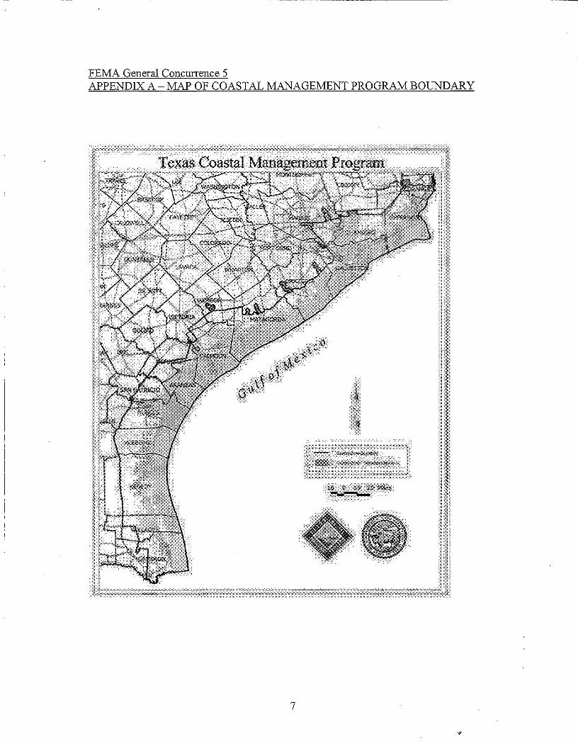
FEMA General Concurrence 5 APPENDIX A - MAP OF COASTAL MANAGEMENT PROGRAM BOUNDARY
7
."

FEMA General Concurrence 5 APPENDIX B - CRITICAL AREAS
Critical Areas. Defined in Texas Natural Resource Code (TNRC) §33.203(8) and 31 TAC §501.3(a)(8) as a coastal wetland, oyster reef, hard substrate reef, submerged aquatic vegetation, or tidal sand or mud flat. Dredging and construction of structures in, or the discharge of dredged or fill material into critical areas must comply with the policies in 31 TAC §501.14(h).
a. Coastal Wetlands. Defined in TNRC §33.203(7) and 31 TAC §501.3(b)(5), are Wetlands, as the term is defined by Texas Water Code §11.502, located:
(1) seaward of the Coastal Facility Designation Line, established by rules adopted under Texas Natural Resources Code, Chapter 40;
(2) within rivers and streams to the extent of tidal influence, as shown on the Texas Natural Resource Conservation Commission's stream segment maps and described as follows:
(a) Arroyo Colorado from FM Road 1847 to a point 100 meters (110 yards) downstream of Cemetery Road south of the Port of Harlingen in Cameron County;
(b) Nueces River from US Highway 77 to the Calallen Dam 1.7 kilometers (1.1 miles) upstream of U.S. Highway 77 in Nueces/San Patricio County;
(c) Guadalupe River from State Highway 35 to the GuadalupeBlanco River Authority Salt Water Barrier at 0.7 kilometers (0.4 miles) downstream of the confluence with the San Antonio River in CalhounlRefugio County;
(d) Lavaca River from FM Road 616 to a point 8.6 kilometers (5.3 miles) downstream of US Highway 59 in Jackson County;
(e) Navidad River from FM Road 616 to Palmetto Bend Dam in Jackson County;
(f) Tres Palacios Creek from FM Road 521 to a point 0.6 kilometer (0.4 mile) upstream of the confluence with Wilson Creek in Matagorda County;
8
'II

(g) Colorado River from FM Road 521 to a point 2.1 kilometers (1.3 miles) downstream of the Missouri-Pacific Railroad in Matagorda County;
(h) San Bernard River from FM Road 521 to a point 3.2 kilometers (2. 0 miles) upstream of State Highway 35 in Brazoria County;
(i) Chocolate Bayou from FM Road 2004 to a point 4.2 kilometers (2.6 miles) downstream of State Highway 35 in Brazoria County;
G) Clear Creek from Interstate Highway 45 to a point 100 meters (110 yards) upstream ofFM Road 528 in GalvestonlHarris County;
(k) Buffalo Bayou (Houston Ship Channel) from Interstate Highway 610 to a point 400 meters (440 yards) upstream of Shepherd Drive in Harris County;
(1) San Jacinto River from Interstate Highway 10 upstream to the Lake Houston dam in Harris County;
(m) Cedar Bayou from Interstate Highway 10 to a point 2.2 kilometers (1.4 miles) upstream of Interstate Highway lOin ChamberslHarris County;
(n) Trinity River from Interstate Highway 10 to the border between Chambers and Liberty Counties;
(0 ) Neches River from Interstate Highway 10 to a point 11.3 kilometers (7.0 miles) upstream of Interstate Highway 10 in Orange County;
(P) Sabine River from Interstate Highway 10 upstream to Morgan Bluff in Orange County; or
(3) within one mile of the mean high tide line of the portion of rivers and streams described by subparagraph (2) of this paragraph, except for the Trinity and Neches rivers.
(a) For the portion of the Trinity River described by subparagraph (2) of this paragraph, coastal wetlands include those wetlands located between the mean high tide line on the western shoreline of that portion of the river and FM Road 565 and FM Road 1409 or located between the mean high tide line on the eastern shoreline of that portion ofthe river and FM Road 563.
9
(b) For the portion of the Neches River described by subparagraph (2) of this paragraph, coastal wetlands include those wetlands located within one mile of the mean high tide line of the western shoreline of that portion of the river or located between the mean high tide line on the eastern shoreline of that portion of the river and FM Road 105.
b. Oyster reef. Defined in TNRC §33.203(13) and 31 TAC §501.3(b)(10), as a natural or artificial formation that is:
(1) composed of oyster shell, live oysters, and other living or dead organIsms; (2) discrete, contiguous, and clearly distinguishable from scattered oyster shell or oysters; and (3) located in an intertidal or subtidal area.
c. Hard substrate reef. A naturally occurring hard substrate formation, including a rock outcrop or serpulid worm reef, living or dead, in an intertidal or subtidal 'area. TNRC §33.203(12) and 31 TAC §501.3(b)(9).
d. Submerged aquatic vegetation. Rooted aquatic vegetation growing in permanently inundated areas in estuarine and marine systems. TNRC §33.203(16) and 31 TAC §501.3(b)(13).
e. Tidal sand or mud flat. A silt, clay, or sand substrate, without regard to whether it is vegetated by algal mats, that occur in intertidal areas and that are regularly or intermittently exposed and flooded by tides, including tides induced by weather. TNRC §33.203(17) and 31 TAC §501.3(b)(14).
10
."

FEMA General Concurrence 5 APPENDIX C - COASTAL HAZARD AREAS
Coastal Hazard Areas are defIned in 31 TAC §501.3(a)(4) as special hazard areas and critical erosion areas. Goals and policies for determining the consistency of development in coastal hazard areas are found in 31 TAC §501.14(l).
a. A "special hazard area" is defIned in TNRC §33.203(14) and 31 TAC §501.3(b)(11) as an area designated under 42 USCA §4001 et seq. as having special flood, mudslide or mudflow, or flood-related erosion hazards and shown on a Flood Hazard Boundary Map or Flood Insurance Rate Map as Zone A, AO, A1-30, AE, A99, AH, VO, V1-30, VE, V, M, or E. Under 31 TAC §501.14(l)(l), subdivisions participating in the National Flood Insurance Program shall adopt ordinances or orders governing development in special hazard areas.
b. A "critical coastal erosion area" or "critical erosion area" is defIned in TNRC §33.60l(4) and 31 TAC §501.3(b)(7) as a coastal area that is experiencing
"historical erosion, according to the most recently published data of the Bureau of Economic Geology of The University of Texas at Austin, that the commissioner fInds to be a threat to:
1. Public health, safety, or welfare; 2. Public beach use or access; 3. General recreation; 4. TraffIc safety; 5. Public property or infrastructure; 6. Private commercial or residential property; 7. Fish or wildlife habitat; or 8. An area of regional or national importance.
11
'J}