VII. Other S. South America - Unconventional Gas South America_June_201… · Bolivia's oil and gas...
19
VII. Other South America EIA/ARI World Shale Gas and Shale Oil Resource Assessment June, 2013 VII-1 VII. OTHER SOUTH AMERICA SUMMARY Four other countries in South America (Bolivia, Chile, Paraguay, and Uruguay) have prospective shale gas and shale oil potential within marine-deposited Cretaceous and Devonian shale formations in three large basins: the Paraná Basin of Paraguay and Uruguay; the Chaco Basin of Bolivia and Paraguay; and the Magallanes Basin of Chile, Figure VII-1. (Extensions of these basins within neighboring Argentina and Brazil were assessed in separate chapters.) Figure VII-1: Prospective Shale Gas and Shale Oil Resources in Bolivia, Chile, Paraguay, and Uruguay. Source: ARI, 2013
Transcript of VII. Other S. South America - Unconventional Gas South America_June_201… · Bolivia's oil and gas...

VII. Other South America EIA/ARI World Shale Gas and Shale Oil Resource Assessment
June, 2013 VII-1
VII. OTHER SOUTH AMERICA
SUMMARY
Four other countries in South America (Bolivia, Chile, Paraguay, and Uruguay) have
prospective shale gas and shale oil potential within marine-deposited Cretaceous and Devonian
shale formations in three large basins: the Paraná Basin of Paraguay and Uruguay; the Chaco
Basin of Bolivia and Paraguay; and the Magallanes Basin of Chile, Figure VII-1. (Extensions of
these basins within neighboring Argentina and Brazil were assessed in separate chapters.)
Figure VII-1: Prospective Shale Gas and Shale Oil Resources in Bolivia, Chile, Paraguay, and Uruguay.
Source: ARI, 2013

VII. Other South America EIA/ARI World Shale Gas and Shale Oil Resource Assessment
June, 2013 VII-2
Risked, technically recoverable shale gas and shale oil resources in these four other
South American countries are estimated at 162 Tcf and 7.2 billion barrels, Tables VII-1 and VII-
2. The geologic setting of this region generally is favorably simple, with mostly gentle structural
dip and relatively few faults or igneous intrusions (apart from surface basalt flows). Technically
recoverable shale resources by country are: Bolivia (36 Tcf; 0.6 billion barrels); Chile (49 Tcf;
2.4 billion barrels); Paraguay (75 Tcf; 3.7 billion barrels); and Uruguay (2 Tcf; 0.6 billion barrels).
Initial shale-related leasing and evaluation has been reported in Paraguay and Uruguay within
existing conventional petroleum license areas.
Table VII-1A. Shale Gas Reservoir Properties and Resources of Bolivia, Chile, Paraguay, and Uruguay.
3,830 3,260 2,350 2,690 1,230
Organically Rich 800 800 800 800 800Net 240 240 240 240 240Interval 10,000 - 11,000 11,000 - 12,000 12,000 - 13,000 3,300 - 5,000 5,000 - 7,000Average 10,500 11,500 12,500 4,000 6,000
Normal Normal Normal Normal Normal
2.0% 2.0% 2.0% 3.6% 3.6%0.85% 1.15% 1.50% 0.85% 1.15%
Low/Medium Low/Medium Low/Medium Low/Medium Low/Medium
Assoc. Gas Wet Gas Dry Gas Assoc. Gas Wet Gas
19.9 44.1 71.2 9.7 46.3
9.1 17.3 20.1 4.2 9.1
0.7 3.5 4.0 0.3 1.8
Physical Extent Prospective Area (mi2)
Thickness (ft)
Depth (ft)
Parana
(747,000 mi2)
Ponta GrossaDevonian
Marine
CordobesDevonian
Marine
Basic Data Basin/Gross Area
Shale FormationGeologic Age
Depositional Environment
Reservoir
Properties Reservoir Pressure
Average TOC (wt. %)Thermal Maturity (% Ro)Clay Content
Resource
Gas Phase
GIP Concentration (Bcf/mi2)
Risked GIP (Tcf)
Risked Recoverable (Tcf)
Table VII-1B. Shale Gas Reservoir Properties and Resources of Bolivia, Chile, Paraguay, and Uruguay.
6,870 9,890 14,210 1,580 1,920 1,500
Organically Rich 1,500 1,500 1,500 800 800 800Net 450 450 450 400 400 400Interval 3,300 - 9,000 7,000 - 12,000 10,000 - 16,400 6,600 - 10,000 10,000 - 14,500 11,500 - 16,400Average 7,000 10,000 13,000 8,000 12,000 13,500
Normal Normal NormalSlightly
Overpress.Slightly
Overpress.Slightly
Overpress.2.5% 2.5% 2.5% 3.5% 3.5% 3.5%
0.85% 1.15% 1.50% 0.85% 1.15% 1.60%Low Low Low Low/Medium Low/Medium Low/Medium
Assoc. Gas Wet Gas Dry Gas Assoc. Gas Wet Gas Dry Gas
27.8 86.8 140.5 32.5 114.8 155.9
28.7 128.7 299.5 23.1 99.2 105.2
2.9 25.7 74.9 2.3 19.8 26.3
Physical Extent Prospective Area (mi2)
Thickness (ft)
Depth (ft)
Basic Data Basin/Gross Area
Shale FormationGeologic Age
Depositional Environment
Reservoir
Properties Reservoir Pressure
Average TOC (wt. %)Thermal Maturity (% Ro)Clay Content
Resource
Gas Phase
GIP Concentration (Bcf/mi2)
Risked GIP (Tcf)
Risked Recoverable (Tcf)
Chaco
(157,000 mi2)
Austral-Magallanes
(65,000 mi2)
Los MonosDevonian
Marine
Estratos con FavrellaL. Cretaceous
Marine
VII. Other South America EIA/ARI World Shale Gas and Shale Oil Resource Assessment
June, 2013 VII-3
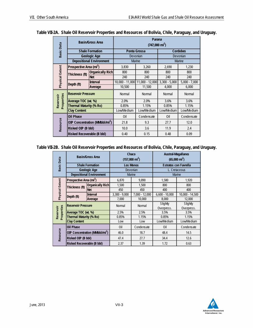
Table VII-2A. Shale Oil Reservoir Properties and Resources of Bolivia, Chile, Paraguay, and Uruguay.
3,830 3,260 2,690 1,230
Organically Rich 800 800 800 800Net 240 240 240 240Interval 10,000 - 11,000 11,000 - 12,000 3,300 - 5,000 5,000 - 7,000Average 10,500 11,500 4,000 6,000
Normal Normal Normal Normal
2.0% 2.0% 3.6% 3.6%0.85% 1.15% 0.85% 1.15%
Low/Medium Low/Medium Low/Medium Low/Medium
Oil Condensate Oil Condensate
21.8 9.3 27.7 12.0
10.0 3.6 11.9 2.4
0.40 0.15 0.48 0.09
Physical Extent Prospective Area (mi2)
Thickness (ft)
Depth (ft)
Parana
(747,000 mi2)
Ponta Grossa CordobesDevonian
MarineDevonian
MarineBasic Data Basin/Gross Area
Shale FormationGeologic Age
Depositional EnvironmentReservo
ir
Properties Reservoir Pressure
Average TOC (wt. %)Thermal Maturity (% Ro)Clay Content
Resource
Oil Phase
OIP Concentration (MMbbl/mi2)
Risked OIP (B bbl)
Risked Recoverable (B bbl)
Table VII-2B. Shale Oil Reservoir Properties and Resources of Bolivia, Chile, Paraguay, and Uruguay.
6,870 9,890 1,580 1,920
Organically Rich 1,500 1,500 800 800Net 450 450 400 400Interval 3,300 - 9,000 7,000 - 12,000 6,600 - 10,000 10,000 - 14,500Average 7,000 10,000 8,000 12,000
Normal NormalSlightly
Overpress.Slightly
Overpress.2.5% 2.5% 3.5% 3.5%0.85% 1.15% 0.85% 1.15%Low Low Low/Medium Low/Medium
Oil Condensate Oil Condensate
46.0 18.7 48.4 14.5
47.4 27.7 34.4 12.6
2.37 1.39 1.72 0.63
Physical Extent Prospective Area (mi2)
Thickness (ft)
Depth (ft)
Basic Data Basin/Gross Area
Shale FormationGeologic Age
Depositional Environment
Reservoir
Properties Reservoir Pressure
Average TOC (wt. %)Thermal Maturity (% Ro)Clay Content
Resource
Oil Phase
OIP Concentration (MMbbl/mi2)
Risked OIP (B bbl)
Risked Recoverable (B bbl)
Austral-Magallanes
(65,000 mi2)
Chaco
(157,000 mi2)
Los MonosDevonian
Marine
Estratos con FavrellaL. Cretaceous
Marine

VII. Other South America EIA/ARI World Shale Gas and Shale Oil Resource Assessment
June, 2013 VII-4
INTRODUCTION
This chapter discusses the shale potential of the other countries in South America
(Argentina, Brazil, and Colombia-Venezuela are assessed in separate chapters). As first
highlighted in EIA/ARI’s 2011 assessment, these other South American countries (Bolivia, Chile,
Paraguay, and Uruguay) have significant shale gas and oil resource potential in favorable
structural settings. Exploration shale drilling has not yet begun in the region although initial
shale leasing and evaluation are underway.
Bolivia. A significant natural gas exporter to Argentina and Brazil, Bolivia produces
natural gas from conventional reservoirs, mainly in the Chaco Basin in the southeast part of the
country. Following 2006 nationalization, YPFB administers investment and production in
Bolivia's oil and gas sector, while the Ministry of Hydrocarbons and Energy (MHE) and the
National Hydrocarbons Agency establish overall policy. Shale exploration or leasing have not
been reported in Bolivia.
Chile. ENAP, the national oil company of Chile, produces about 5,000 bbl/day mainly
from conventional reservoirs in the Magallanes basin.1 In March 2011 ENAP announced that it
will require companies bidding for conventional oil and gas exploration blocks to also explore for
shale gas. While exploration is underway for tight gas sandstone reservoirs in the basin, no
shale-specific exploration has been reported in Chile.
Paraguay. Paraguay does not produce oil and gas, although extensions of its
sedimentary basins are productive in both Argentina and Bolivia. Only two conventional
petroleum wells have been drilled in Paraguay during the past 25 years. Shale drilling has not
occurred in the country but President Energy is investigating the shale potential at its
conventional petroleum licenses in the Chaco Basin.
Uruguay. Uruguay also does not produce oil and gas, although extensions of its
sedimentary basins are productive in neighboring Brazil and Argentina. ANCAP (Administración
Nacional de Combustibles, Alcoholes y Portland), the state-owned oil company in Uruguay,
administers the country’s petroleum licensing. TOTAL, YPF, and others hold leases in the
onshore Paraná Basin and are evaluating the shale potential.
VII. Other South America EIA/ARI World Shale Gas and Shale Oil Resource Assessment
June, 2013 VII-5
Three major sedimentary basins with prospective organic-rich and marine-deposited
black shales are present in Bolivia, Chile, Paraguay, and Uruguay, Figure VII-1. These basins,
which were assessed in this chapter, are:
Paraná Basin (Paraguay, Uruguay): The Paraná Basin contains black shale within the
Devonian Ponta Grossa Formation. The structural setting is simple but the basin is
partly obscured at surface by flood basalts, although this igneous cap is less prevalent
here than in the Brazil portion of the basin.
Chaco Basin (Paraguay, Bolivia): Black shale in the Devonian Los Monos Formation is
present within a relatively simple structural setting in northwest Paraguay. The shale
becomes increasingly deep and thrust faulted in southeast Bolivia, where they source
that country’s prolific conventional reservoirs.
Magallanes Basin (Chile): Known as the Austral Basin in Argentina, the Magallanes
Basin of southern Chile contains marine-deposited black shale in the Lower Cretaceous
Estratos con Favrella Formation, considered a major source rock in the basin.
1 PARANÁ BASIN (PARAGUAY, URUGUAY)
1.1 Introduction and Geologic Setting
The Paraná Basin is a large depositional feature in south-central South America. Most
of the basin is located in southern Brazil, but there are significant extensions into Paraguay,
Uruguay, and northern Argentina, Figure VII-2. This section focuses on the Paraguay and
Uruguay portions of the basin. The Paraná Basin contains up to 5 km (locally 7 km) of
Paleozoic and Mesozoic sedimentary rocks that range from Late Ordovician to Cretaceous. Its
western border is defined by the Asuncion Arch, related to Andean thrusting, while the east is
truncated by the South Atlantic tectonic margin.2 Much of the Brazilian portion of the basin is
covered by flood basalts, partly obscuring the underlying geology from seismic and increasing
the cost of drilling, but the Paraguay portion is largely free of basalt.
The main petroleum source rock in the Paraná Basin is the Devonian (Emsian/Frasnian)
black shale of the Ponta Grossa Formation. The entire formation ranges up to 600 m thick in
the center of the basin, averaging about 300 m thick. TOC of the Ponta Grossa Fm reaches up
to 4.6% but more typically is 1.5% to 2.5%. The mostly Type II kerogen sourced natural gas
that migrated into conventional sandstone reservoirs.3
VII. Other South America EIA/ARI World Shale Gas and Shale Oil Resource Assessment
June, 2013 VII-6
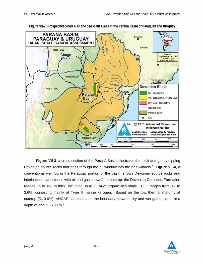
Figure VII-2: Prospective Shale Gas and Shale Oil Areas in the Paraná Basin of Paraguay and Uruguay
Figure VII-3, a cross-section of the Paraná Basin, illustrates the thick and gently dipping
Devonian source rocks that pass through the oil window into the gas window.4 Figure VII-4, a
conventional well log in the Paraguay portion of the basin, shows Devonian source rocks and
interbedded sandstones with oil and gas shows.5 In outcrop, the Devonian Cordobes Formation
ranges up to 160 m thick, including up to 60 m of organic-rich shale. TOC ranges from 0.7 to
3.6%, consisting mainly of Type II marine kerogen. Based on the low thermal maturity at
outcrop (Ro 0.6%), ANCAP has estimated the boundary between dry and wet gas to occur at a
depth of about 3,200 m.6

VII. Other South America EIA/ARI World Shale Gas and Shale Oil Resource Assessment
June, 2013 VII-7
Figure VII-3: Cross-Section of the Paraná Basin of Paraguay, Showing Thick and Gently Dipping Devonian
Source Rocks Passing Through the Oil and Gas Windows.
Source: Chaco Resources PLC, 2004 Figure VII-4: Asuncion-1 Well Log from the Paraná Basin of Paraguay, Showing Devonian Source Rocks and
Interbedded Sandstones with Oil and Gas Shows.
Source: Guapex S.A., 2012
VII. Other South America EIA/ARI World Shale Gas and Shale Oil Resource Assessment
June, 2013 VII-8
The Paraná Basin has remained at moderate burial depth throughout its history.
Consequently, the bulk of thermal maturation took place during the late Jurassic to early
Cretaceous igneous episode. Most of the basin remains thermally immature (Ro <0.5%), but
there are sizeable concentric windows of oil-, wet-gas-, and dry-gas maturity in the deep central
portion of the basin.
1.2 Reservoir Properties (Prospective Area)
Depth and thermal maturity of the Devonian Ponta Grossa Formation are relatively well
constrained in the Paraguay portion of the Paraná Basin. The prospective area in Paraguay is
estimated at 9,440 mi2, of which 3,830 mi2 is in the oil window; 3,260 mi2 is in the wet
gas/condensate thermal maturity window; and 2,350 mi2 is in the dry gas window.
However, Devonian depth and thermal maturity are much less certain in Uruguay.
Uruguay’s shale-prospective area is estimated at 3,920 mi2, of which 2,690 mi2 is in the oil
window and 1,230 mi2 is in the wet gas/condensate thermal maturity window (no evidence the
Devonian attains dry-gas thermal maturity in Uruguay). The Ponta Grossa shale averages
about 240 m thick (net), 10,500 to 12,500 ft deep in Paraguay but only 4,000 to 6,000 ft deep in
Uruguay, and averages 2.0% to 3.6% TOC.
Thermal maturity (Ro) ranges from 0.85% to 1.5% depending mainly on depth. For
example, Amerisur reported that the Devonian Lima Fm has good (2-3%) TOC and is oil-prone
(Ro 0.87%) at their conventional exploration block. Porosity is estimated at about 4% and the
pressure gradient is assumed to be hydrostatic.
1.3 Resource Assessment
Risked, technically recoverable shale gas and oil resources from the Devonian Ponta
Grossa Shale in the Paraguay portion of the Paraná Basin are estimated at 8 Tcf of shale gas
and 0.6 billion barrels of shale oil and condensate, Tables VII-1 and VII-2. Uruguay has further
estimated resources of 2 Tcf of shale gas and 0.6 billion barrels of shale oil and condensate in
this play. Risked shale gas and shale oil in-place in Paraguay and Uruguay are estimated at 60
Tcf and 28 billion barrels. The play has low-moderate net resource concentrations of 10 to 71
Bcf/mi2 for shale gas and 9 to 28 million bbl/mi2 for shale oil, depending on thermal maturity
window.
VII. Other South America EIA/ARI World Shale Gas and Shale Oil Resource Assessment
June, 2013 VII-9
The USGS recently estimated that Uruguay’s portion of the Paraná Basin (Norte Basin)
has 13.4 Tcf of shale gas and 0.5 billion barrels of shale oil resources in the Devonian Cordobes
Formation. They noted that the sub-basalt extent of inferred deep grabens for their study was
imaged by ANCAP using geophysical methods, with no well control.7 Petrel Energy recently
noted that new data indicates the Devonian is less thermally mature than mapped by the
USGS.8 The EIA/ARI thermal windows were adjusted accordingly.
1.4 Recent Activity
TOTAL, YPF, and small Australia-based Petrel Energy hold large exploration licenses
with Devonian shale potential in the Uruguay portion of the Paraná Basin (Norte Basin). No
shale-focused drilling has occurred in Uruguay, nor has shale leasing or drilling activity been
reported in the Paraguay portion of the Paraná Basin.
2 CHACO BASIN (BOLIVIA, PARAGUAY)
2.1 Introduction and Geologic Setting
The large (157,000-mi2) Chaco Basin is an intra-cratonic foreland basin broadly similar in
origin to the Neuquen and other South American basins east of the Andes Mountains, Figure
VII-5. The Chaco Basin extends across southeast Bolivia and northwest Paraguay, as well as
southern Brazil and northern Argentina (please see separate chapters for these countries).
Structural highs (Ascuncion Arch) separate the Chaco Basin from the Parana Basin to the
southeast. Structure is relatively simple, with scattered mainly vertical normal faults and none of
the thrusting typical of Andean tectonics further to the west.
Sub-basins include the Pirity, Carandayty, and Curupayty troughs. Oil and gas
production occurs in Bolivia and Argentina but not in Paraguay, which has experienced much
less drilling. Fewer than 10 petroleum wells have been drilled in the Pirity Sub-basin of
Paraguay, all pre-1987, where no commercial production has occurred. However, the Argentina
portion of the Basin (Olmedo Sub-basin) has produced over 110 million bbls of oil from the
Upper Cretaceous Yacoraite and Palmer Largo formations and that basin continues to be
productive.9 Apart from the international border, no geologic discontinuity separates the two
sub-basins.
VII. Other South America EIA/ARI World Shale Gas and Shale Oil Resource Assessment
June, 2013 VII-10
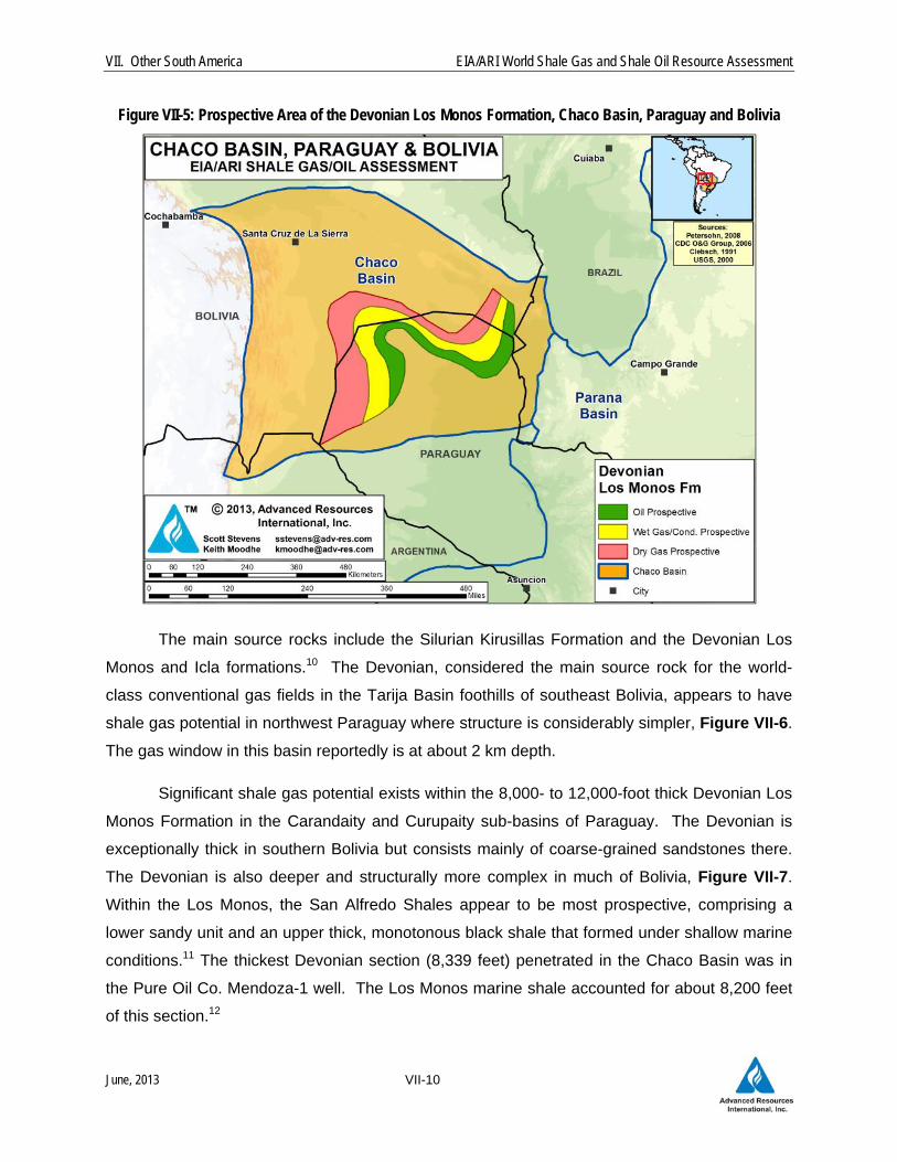
Figure VII-5: Prospective Area of the Devonian Los Monos Formation, Chaco Basin, Paraguay and Bolivia
The main source rocks include the Silurian Kirusillas Formation and the Devonian Los
Monos and Icla formations.10 The Devonian, considered the main source rock for the world-
class conventional gas fields in the Tarija Basin foothills of southeast Bolivia, appears to have
shale gas potential in northwest Paraguay where structure is considerably simpler, Figure VII-6.
The gas window in this basin reportedly is at about 2 km depth.
Significant shale gas potential exists within the 8,000- to 12,000-foot thick Devonian Los
Monos Formation in the Carandaity and Curupaity sub-basins of Paraguay. The Devonian is
exceptionally thick in southern Bolivia but consists mainly of coarse-grained sandstones there.
The Devonian is also deeper and structurally more complex in much of Bolivia, Figure VII-7.
Within the Los Monos, the San Alfredo Shales appear to be most prospective, comprising a
lower sandy unit and an upper thick, monotonous black shale that formed under shallow marine
conditions.11 The thickest Devonian section (8,339 feet) penetrated in the Chaco Basin was in
the Pure Oil Co. Mendoza-1 well. The Los Monos marine shale accounted for about 8,200 feet
of this section.12
VII. Other South America EIA/ARI World Shale Gas and Shale Oil Resource Assessment
June, 2013 VII-11
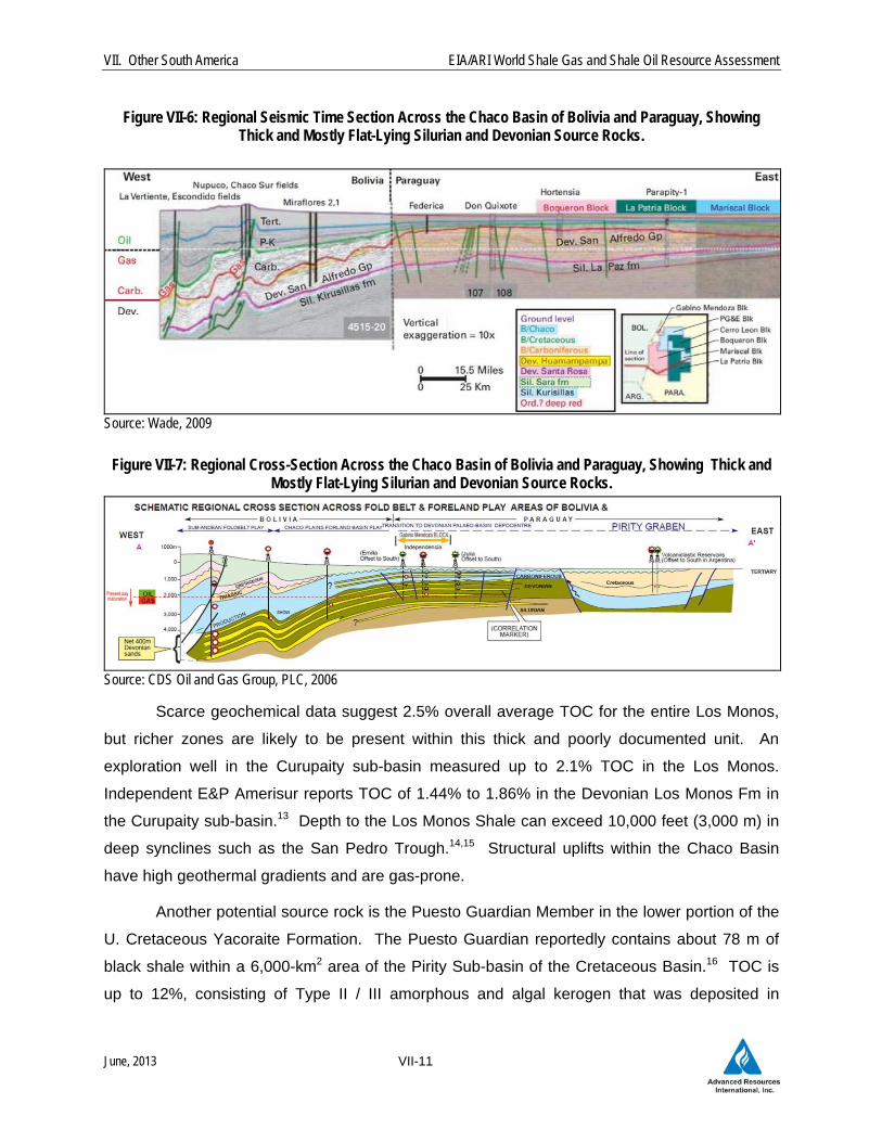
Figure VII-6: Regional Seismic Time Section Across the Chaco Basin of Bolivia and Paraguay, Showing Thick and Mostly Flat-Lying Silurian and Devonian Source Rocks.
Source: Wade, 2009
Figure VII-7: Regional Cross-Section Across the Chaco Basin of Bolivia and Paraguay, Showing Thick and Mostly Flat-Lying Silurian and Devonian Source Rocks.
Source: CDS Oil and Gas Group, PLC, 2006
Scarce geochemical data suggest 2.5% overall average TOC for the entire Los Monos,
but richer zones are likely to be present within this thick and poorly documented unit. An
exploration well in the Curupaity sub-basin measured up to 2.1% TOC in the Los Monos.
Independent E&P Amerisur reports TOC of 1.44% to 1.86% in the Devonian Los Monos Fm in
the Curupaity sub-basin.13 Depth to the Los Monos Shale can exceed 10,000 feet (3,000 m) in
deep synclines such as the San Pedro Trough.14,15 Structural uplifts within the Chaco Basin
have high geothermal gradients and are gas-prone.
Another potential source rock is the Puesto Guardian Member in the lower portion of the
U. Cretaceous Yacoraite Formation. The Puesto Guardian reportedly contains about 78 m of
black shale within a 6,000-km2 area of the Pirity Sub-basin of the Cretaceous Basin.16 TOC is
up to 12%, consisting of Type II / III amorphous and algal kerogen that was deposited in
VII. Other South America EIA/ARI World Shale Gas and Shale Oil Resource Assessment
June, 2013 VII-12
lacustrine to restricted marine environments. Peak hydrocarbon maturation and charge is
estimated to have occurred 34-40 million years ago, with current maturity in the oil window.
However, the potential of the Cretaceous shale was not assessed due to insufficient geologic
control.
2.2 Reservoir Properties (Prospective Area)
The Devonian Los Monos Formation is exceptionally thick (as much as 12,000 feet) in
the Chaco Basin, of which 2,000 feet (San Alfredo Shales) was conservatively assumed to be
organic-rich. Faulting is not extensive, thus relatively little area is sterilized due to structural
complexity.
The shale matrix reportedly consists primarily of brittle minerals such as calcite,
dolomite, albite feldspar, ankerite, quartz as well as significant rutile and pyrite. Some clay is
present -- mainly illite, kaolinite and chlorite – but is considered “less common.”17 Temperature
gradients range from elevated 1.9°F/100 feet on structural highs to 1.0°F/100 feet in the
Carandaity sub-basin.
Depth and thermal maturity of the Devonian Los Monos Formation are relatively well
constrained in the Paraguay portion of the Chaco Basin. The prospective area in Paraguay is
estimated at 22,210 mi2, of which 6,200 mi2 is in the oil window; 7,450 mi2 is in the wet
gas/condensate thermal maturity window; and 8,560 mi2 is in the dry gas window. An additional
8,760 mi2 is prospective in Bolivia, of which 670 mi2 is in the oil window; 2,440 mi2 is in the wet
gas/condensate thermal maturity window; and 5,650 mi2 is in the dry gas window.
2.3 Resource Assessment
Risked, technically recoverable shale gas and shale oil resources from the Devonian Los
Monos black shale in the Paraguay portion of the Chaco Basin are estimated at 67 Tcf of shale
gas and 3.2 billion barrels of shale oil and condensate, Tables VII-1 and VII-2. Bolivia has
further estimated resources of 37 Tcf of shale gas and 0.6 billion barrels of shale oil and
condensate. Risked shale gas and shale oil in-place are estimated at 457 Tcf of shale gas and
75 billion barrels of shale oil for the two countries. The play has moderate to high net resource
concentrations of 28 to 141 Bcf/mi2 for shale gas and 19 to 46 million bbl/mi2 for shale oil,
depending on thermal maturity window.

VII. Other South America EIA/ARI World Shale Gas and Shale Oil Resource Assessment
June, 2013 VII-13
2.4 Recent Activity
Initial shale evaluation is occurring on existing conventional petroleum exploration leases
in the Chaco Basin, but no shale-specific drilling or testing has occurred yet. President Energy
PLC (UK) holds eight conventional petroleum exploration licenses which it considers to have
shale gas/oil potential.
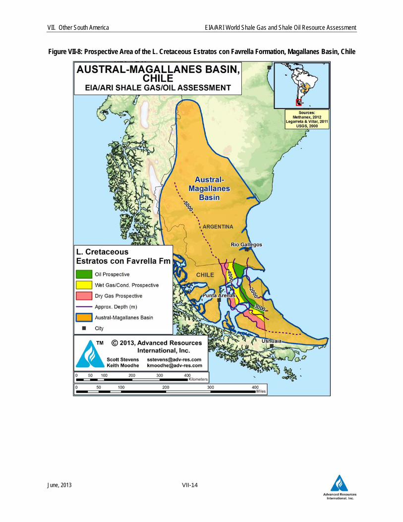
3 MAGALLANES BASIN (CHILE)
3.1 Introduction and Geologic Setting
Located in southern Patagonia, the 65,000-mi2 Austral-Magallanes Basin has promising
but untested shale gas potential, Figure VII-8. While most of the basin is in Argentina, where it
is called the Austral Basin, a portion of the basin is located in Chile’s Tierra del Fuego region,
where it is referred to as the Magallanes Basin. The Chile portion of the basin, which started
producing conventional natural gas over 60 years ago, currently accounts for most of that
country’s oil and gas output, produced primarily from deltaic to fluvial sandstones in the Early
Cretaceous Springhill Formation at depths of about 6,000 feet.
The Magallanes Basin comprises two main structural regions: a normal faulted eastern
region and a thrust faulted western area. The basin contains a thick sequence of Upper
Cretaceous and Tertiary sedimentary and volcaniclastic rocks which unconformably overlie
deformed metamorphic basement of Paleozoic age. Total sediment thickness ranges from
3,000 to 6,000 feet along the eastern coast to a maximum 25,000 feet along the basin axis.
Jurassic and Lower Cretaceous petroleum source rocks are present at moderate depths of
6,000 to 10,000 feet across large areas.18 The overlying Cretaceous section comprises mainly
deepwater turbidite clastic deposits up to 4 km thick, which appear to lack shale gas and oil
potential.19
VII. Other South America EIA/ARI World Shale Gas and Shale Oil Resource Assessment
June, 2013 VII-14
Figure VII-8: Prospective Area of the L. Cretaceous Estratos con Favrella Formation, Magallanes Basin, Chile

VII. Other South America EIA/ARI World Shale Gas and Shale Oil Resource Assessment
June, 2013 VII-15
The organic-rich shales of Jurassic and Early Cretaceous age formed under anoxic
marine conditions within a Neocomian sag on the edge of the Andes margin, Figure VII-9. The
basal sequence consists of Jurassic source rocks that accumulated under restricted lacustrine
conditions within small half-grabens. Interbedded shale and sandstone of the Zapata and Punta
Barrosa formations were deposited in a shallow-water marine environment.20 The mid-lower
Jurassic Tobifera Formation contains 1% to 3% TOC (maximum 10% in coaly shales),
consisting of Types I to III kerogen. However, this unit is mainly coaly and probably
insufficiently brittle for shale exploration.
Figure VII-9: Stratigraphy of the Austral-Magallanes Basin, Argentina and Chile
MARGAS VERDES FM
LOWER INOCERAMUS
FM
Source: Rossello et al., 2008

VII. Other South America EIA/ARI World Shale Gas and Shale Oil Resource Assessment
June, 2013 VII-16
Overlying the Tobifera Fm are more prospective shales within the Early Cretaceous
Estratos con Favrella Formation (or Lower Inoceramus or Palermo Aike in Argentina), deposited
under shallow water marine conditions. The Lower Inoceramus Formation is 50 to 400 m thick.
In the Argentina portion of the basin, the total shale thickness (including the Magnas Verdes
Formation) ranges from 800 feet thick in the north to 4,000 feet thick in the south, representing
neritic facies deposited in a low-energy and anoxic environment.21 Total organic content of
these two main source rocks have been reported to range from 1.0% to 2.0%, with hydrogen
index of 150 to 550 mg/g.22 More recent analysis conducted by Chesapeake Energy of the
Lower Cretaceous Estratos con Favrella Formation in Chile indicates this unit contains marine-
deposited shale with consistently good to excellent (up to 6%) TOC, particularly near its base.23
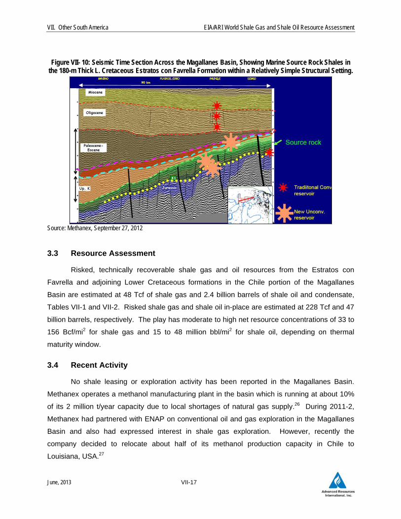
Figure VII-10, a seismic time section across the basin, shows the 180-m thick Estratos
con Favrella Formation dipping gently west in a relatively simple structural setting. Net organic-
rich shale thickness was estimated by ENAP to be only 40 to 120 ft, although this appears
conservative and we assumed 280 net ft. ENAP also estimated porosity of 6% to 12%, but we
assumed a more conservative estimate of 6%. Thermal maturity increases gradually with depth
in a half-moon pattern, ranging from oil-prone (Ro 0.8%) to dry gas prone (Ro 2.0%). The
transition from wet to dry gas (Ro 1.3%) occurs at a depth of about 3,600 m in this basin.24
3.2 Reservoir Properties (Prospective Area)
Chile’s portion of the Magallanes Basin has an estimated 5,000-mi2 prospective area
with organic-rich shale in the Estratos con Favrella and adjoining Lower Cretaceous formations.
Of this total prospective area, about 1,580 mi2 is in the oil window; 1,920 mi2 is in the wet
gas/condensate thermal maturity window; and 1,500 mi2 is in the dry gas window. The Estratos
con Favrella and adjoining shales average about 800 ft thick (organic-rich), 8,000 to 13,500 ft
deep, and have estimated 3.5% average TOC. Thermal maturity (Ro) ranges from 0.7% to 2.0%
depending mainly on depth. Porosity is estimated at about 5%. The Estancia Los Lagunas gas
condensate field in southeast Argentina measured a 0.46 psi/ft pressure gradient with elevated
temperature gradients in the Serie Tobifera Fm, immediately underlying the Lower Inoceramus
equivalent.25
VII. Other South America EIA/ARI World Shale Gas and Shale Oil Resource Assessment
June, 2013 VII-17
Figure VII- 10: Seismic Time Section Across the Magallanes Basin, Showing Marine Source Rock Shales in
the 180-m Thick L. Cretaceous Estratos con Favrella Formation within a Relatively Simple Structural Setting.
Source: Methanex, September 27, 2012
3.3 Resource Assessment
Risked, technically recoverable shale gas and oil resources from the Estratos con
Favrella and adjoining Lower Cretaceous formations in the Chile portion of the Magallanes
Basin are estimated at 48 Tcf of shale gas and 2.4 billion barrels of shale oil and condensate,
Tables VII-1 and VII-2. Risked shale gas and shale oil in-place are estimated at 228 Tcf and 47
billion barrels, respectively. The play has moderate to high net resource concentrations of 33 to
156 Bcf/mi2 for shale gas and 15 to 48 million bbl/mi2 for shale oil, depending on thermal
maturity window.
3.4 Recent Activity
No shale leasing or exploration activity has been reported in the Magallanes Basin.
Methanex operates a methanol manufacturing plant in the basin which is running at about 10%
of its 2 million t/year capacity due to local shortages of natural gas supply.26 During 2011-2,
Methanex had partnered with ENAP on conventional oil and gas exploration in the Magallanes
Basin and also had expressed interest in shale gas exploration. However, recently the
company decided to relocate about half of its methanol production capacity in Chile to
Louisiana, USA.27

VII. Other South America EIA/ARI World Shale Gas and Shale Oil Resource Assessment
June, 2013 VII-18
UK-based GeoPark holds conventional petroleum leases in the Magallanes Basin of
Chile, which the company notes contains shales in the Estratos con Favrella Formation which
previously have produced oil. In 2012 GeoPark conducted diagnostic fracture injection tests on
eight wells on the Fell Block to determine reservoir properties of the shale.28
REFERENCES
1 ENAP (Empresa Nacional del Petróleo), 4Q 2012 Results, April 2013, Santiago, Chile, 28 p. 2 Milani, E.J. and Zalán, P.V., 1999. “An Outline of the Geology and Petroleum Systems of the Paleozoic
Interior Basins of South America.” Episodes, vol. 22, p. 199-205. 3 Vesely, F.F., Rostirolla, S.P., Appi, C.J., Kraft, E.P., 2007. ”Late Paleozoic Glacially Related Sandstone
Reservoirs in the Parana Basin, Brazil. American Association of Petroleum Geologists, Bulletin, vol. 91, p. 151-160.
4 Chaco Resources PLC, 2004. “Proposed Acquisition of Amerisur S.A. and Bohemia S.A., Notice of Extraordinary General Meeting.” 83 p.
5 Guapex S.A., 2012. “Unconventional Gas in Paraguay.” 21 p. 6 US Geological Survey, 2011. “Assessment of Potential Shale Gas and Shale Oil Resources of the
Norte Basin, Uruguay, 2011.” 2 p. 7 US Geological Survey, 2011. “Assessment of Potential Shale Gas and Shale Oil Resources of the
Norte Basin, Uruguay, 2011.” 2 p. 8 Petrel Energy Limited, Investor Presentation, November 2012, 22 p. 9 President Energy PLC, Resource Evaluation prepared by DeGoyler and MacNaughton, December 15,
2012, 27 p. 10 Wade, J., 2009. “Nonproducing Paraguay’s Potential Conventional and Unconventional.” Oil and Gas
Journal, April 6, p. 39-42. 11 Petzet, A., 1997. “Nonproducing Paraguay to get Rare Wildcats.” Oil and Gas Journal, April 21. 12 Wiens, F., 1995. “Phanerozoic Tectonics and Sedimentation in the Chaco Basin of Paraguay, with
Comments on Hydrocarbon Potential.” ln A. J. Tankard, R. Suarez S., and H. J. Welsink, eds., Petroleum Basins of South America. American Association of Petroleum Geologists Memoir 62, p. 185-205.
13 Amerisur Resources PLC, 2009. Interim Results Presentation, December, 36 p. 14 Kuhn, C.A.C., 1991. “The Geological Evolution of the Paraguayan Chaco.” Ph.D. dissertation, Texas
Tech. 15 Grupo Montecristo, 2012. “Unconventional Gas in Paraguay.” 21 p. 16 President Energy PLC, Investor Presentation, January 2013, 32 p. 17 Kern, M., Machado, G., Franco, N., Mexias, A., Vargas T., Costa, J., and Kalkreuth, W. 2004. “Source
Rock Characterization of Paraná Basin, Brazil: Sem and XRD Study of Irati and Ponta Grossa Formations Samples.” 3° Congresso Brasileiro de P&D em Petróleo e Gás, 2 a 5 de outubro de 2005, Salvador, Brasil.
18 Rodriquez, J. and Cagnolatti, M.J., 2008. “Source Rocks and Paleogeography, Austral Basin, Argentina.” American Association of Petroleum Geologists, Search and Discovery Article #10173, 24 p.

VII. Other South America EIA/ARI World Shale Gas and Shale Oil Resource Assessment
June, 2013 VII-19
19 Romans, B.W., Fildani, A., Hubbard, S.M., Covault, J.A., Fosdick, J.C., and Graham, S.A., 2011.
“Evolution of Deep-water Stratigraphic Architecture, Magallanes Basin, Chile.” Marine and Petroleum Geology, vol. 28, p. 612-628.
20 Fildani, A. and Hessler, A.M., 2005. “Stratigraphic Record Across a Retroarc Basin Inversion: Rocas Verdes–Magallanes Basin, Patagonian Andes, Chile.” Geological Society of America, vol. 117, p. 1596-1614.
21 Ramos, V.A., 1989. “Andean Foothills Structures in Northern Magallanes Basin, Argentina.” American Association of Petroleum Geologists, Bulletin, vol. 73, no. 7, p. 887-903.
22 Pittion, J.L. and Arbe, H.A., 1999. “Sistemes Petroleros de la Cuenca Austral.” IV Congreso Exploracion y Desarrollo de Hidrocarburos, Mar del Plata, Argentina, Actas I, p. 239-262.
23 Methanex, Investor Presentation, September 27, 2012, 129 p. 24 Legarreta, L. and Villar, H.J., 2011. “Geological and Geochemical Keys of the Potential Shale
Resources, Argentina Basins.” American Association of Petroleum Geologists, Search and Discovery Article, Adapted from AAPG Geoscience Technology Workshop, “Unconventional Resources: Basics, Challenges, and Opportunities for New Frontier Plays,” Buenos Aires, Argentina, June 26-28, 2011.
25 Venara, L., Chambi, G.B., Cremonini, A., Limeres, M., and Dos Lagunas, E., 2009. “Producing Gas And Condensate From a Volcanic Rock In The Argentinean Austral Basin.” 24th World Gas Congress, 5-9 October, Buenos Aires, Argentina.
26 Methanex, Investor Presentation, March 2013, 37 p. 27 Methanex, news release, April 2013. 28 GeoPark Holdings Limited, “Second Quarter 2012 Operations Update,” July 23, 2012, 6 p.