VICTORIAN CLASS 2 B-DOUBLE ROUTE ACCESS LISTSMount Baw Baw Road, north of Willowgrove Road Baw Baw...
75
VICTORIAN CLASS 2 B-DOUBLE ROUTE ACCESS LISTS FEBRUARY 2014
Transcript of VICTORIAN CLASS 2 B-DOUBLE ROUTE ACCESS LISTSMount Baw Baw Road, north of Willowgrove Road Baw Baw...
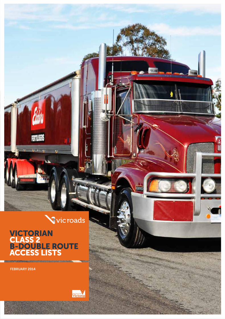
VICTORIAN CLASS 2 B-DOUBLE ROUTE ACCESS LISTS
FEBRUARY 2014

2
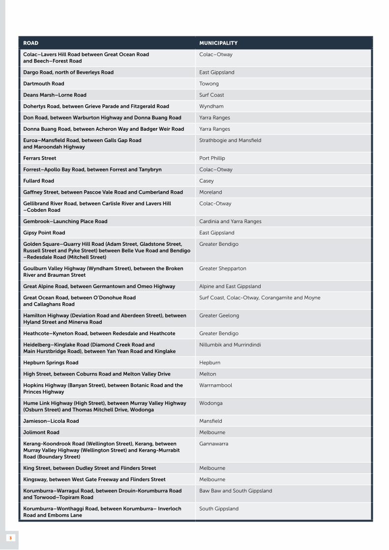
TABLE A – PROHIBITED ARTERIAL ROADS WHICH B-DOUBLES MUST NOT USE (Including roads with prohibited bridges)
ROAD MUNICIPALITY
Acheron Way Murrindindi and Yarra Ranges
Albert Road, between Kings Way and Canterbury Road Port Phillip
Alexandra Avenue, between Grange Road and Williams Road North Stonnington
Ararat-St.Arnaud Road, between Buangor-Ben Nevis Road and Wright Street
Ararat and Pyrenees
Arthurs Seat Road Mornington Peninsula
Avenel–Nagambie Road, between Goulburn Valley Highway and Spencer Road
Strathbogie
Barkers Road, between Yarra River and Church Street Boroondara
Beach Road (Beach Street, Beaconsfield Parade, Jacka Boulevard, Marine Parade, Ormond Esplanade, St.Kilda Street, Esplanade)
Bayside, Kingston and Port Phillip
Beech Forest Road, between Lardners Road and Haines Junction Colac–Otway
Beechworth–Wodonga Road (Beechworth Road), between Thomas Mitchell Drive and Pearce Street
Wodonga
Bells Beach Road Surf Coast
Benalla-Winton Road (Bridge Street), between Midland Highway (Nunn Street) and Benalla-Tatong Road (Smythe Street)
Benalla
Benalla-Yarrawonga Road, between St.James Road and Lake Rowan Road
Moira
Benambra–Corryong Road East Gippsland and Towong
Bendigo–Maryborough Road, between Pyrenees Highway and Gladstone Street
Central Goldfields
Bendigo–Redesdale Road (Mitchell Street and Miller Street), between Myers–Wills Street and Sternberg Street
Greater Bendigo
Bogong High Plains Road Alpine
Bonang Road, north of Sardine Creek Road East Gippsland
Boolarra–Mirboo North Road Latrobe and South Gippsland
Boolarra Road, south of Boolarra South Latrobe
Bright–Tawonga Road Alpine
Brunswick Street, between Alexandra Parade and St Georges Road Yarra
Brunton Avenue Melbourne
Buckland Gap Road Indigo and Wangaratta
Burgundy Street (Bell Street Road) Banyule
Burke Road North, between Eastern Freeway and Lower Heidelberg Road
Banyule
Cameron Drive Macedon Ranges
Canterbury Road Port Phillip
Carlisle–Colac Road Colac–Otway
City Road, between Clarendon Street and Ferrars Street Melbourne and Port Phillip
Clarendon Street Melbourne and Port Phillip
Cobden–Port Campbell Road, between Warrnambool– Cobden Road and Scotts Creek
Corangamite
Cohuna–Echuca Road Campaspe
3
ROAD MUNICIPALITY
Colac–Lavers Hill Road between Great Ocean Road and Beech–Forest Road
Colac–Otway
Dargo Road, north of Beverleys Road East Gippsland
Dartmouth Road Towong
Deans Marsh–Lorne Road Surf Coast
Dohertys Road, between Grieve Parade and Fitzgerald Road Wyndham
Don Road, between Warburton Highway and Donna Buang Road Yarra Ranges
Donna Buang Road, between Acheron Way and Badger Weir Road Yarra Ranges
Euroa–Mansfield Road, between Galls Gap Road and Maroondah Highway
Strathbogie and Mansfield
Ferrars Street Port Phillip
Forrest–Apollo Bay Road, between Forrest and Tanybryn Colac–Otway
Fullard Road Casey
Gaffney Street, between Pascoe Vale Road and Cumberland Road Moreland
Gellibrand River Road, between Carlisle River and Lavers Hill –Cobden Road
Colac-Otway
Gembrook–Launching Place Road Cardinia and Yarra Ranges
Gipsy Point Road East Gippsland
Golden Square–Quarry Hill Road (Adam Street, Gladstone Street, Russell Street and Pyke Street) between Belle Vue Road and Bendigo –Redesdale Road (Mitchell Street)
Greater Bendigo
Goulburn Valley Highway (Wyndham Street), between the Broken River and Brauman Street
Greater Shepparton
Great Alpine Road, between Germantown and Omeo Highway Alpine and East Gippsland
Great Ocean Road, between O’Donohue Road and Callaghans Road
Surf Coast, Colac-Otway, Corangamite and Moyne
Hamilton Highway (Deviation Road and Aberdeen Street), between Hyland Street and Minerva Road
Greater Geelong
Heathcote–Kyneton Road, between Redesdale and Heathcote Greater Bendigo
Heidelberg–Kinglake Road (Diamond Creek Road and Main Hurstbridge Road), between Yan Yean Road and Kinglake
Nillumbik and Murrindindi
Hepburn Springs Road Hepburn
High Street, between Coburns Road and Melton Valley Drive Melton
Hopkins Highway (Banyan Street), between Botanic Road and the Princes Highway
Warrnambool
Hume Link Highway (High Street), between Murray Valley Highway (Osburn Street) and Thomas Mitchell Drive, Wodonga
Wodonga
Jamieson–Licola Road Mansfield
Jolimont Road Melbourne
Kerang-Koondrook Road (Wellington Street), Kerang, between Murray Valley Highway (Wellington Street) and Kerang-Murrabit Road (Boundary Street)
Gannawarra
King Street, between Dudley Street and Flinders Street Melbourne
Kingsway, between West Gate Freeway and Flinders Street Melbourne
Korumburra–Warragul Road, between Drouin-Korumburra Road and Torwood–Topiram Road
Baw Baw and South Gippsland
Korumburra–Wonthaggi Road, between Korumburra– Inverloch Road and Emboms Lane
South Gippsland

4
ROAD MUNICIPALITY
Lake Mountain Road Murrindindi
Lang Lang–Poowong Road, between Mt Lyall Road and Drouin –Korumburra Road
South Gippsland
Lansdowne Street Melbourne
Lavers Hill–Cobden Road, between Simpson and Lavers Hill Corangamite and Colac–Otway
Lockharts Gap Road Indigo and Towong
Lysterfield Road, between Napoleon Road and Wellington Road Knox and Yarra Ranges
Mallacoota Road East Gippsland
Mansfield–Woods Point Road, south of Jamieson–Licola Road Mansfield
Maroondah Highway, between Saint Fillans and Don Road Murrindindi and Yarra Ranges
McIvor Highway, between Don Street and Chapel Street Greater Bendigo
McKillops Road East Gippsland
Meeniyan–Mirboo North Road South Gippsland
Midland Highway, between Faithful Street and Nunn Street Benalla
Midland Highway, between Chapel Street and Nolan Street Greater Bendigo
Monbulk Road, between Kallista and Monbulk Yarra Ranges
Montague Street, between Normanby Road and City Road Port Phillip
Mount Baw Baw Road, north of Willowgrove Road Baw Baw
Mount Buffalo Road Alpine
Mount Buller Road (High Street), between Midland Highway and Mansfield-Whitfield Road
Mansfield
Mount Buller Road, east of Sawmill Settlement Mansfield
Mount Dandenong Tourist Road Yarra Ranges
Mount Macedon Road Macedon Ranges
Mount Macedon–Hanging Rock Road Macedon Ranges
Murrungower Road, north of the 12km post (north of Tarlton Track) from Princes Highway
East Gippsland
Myers–Wills Street (Myers Street, Wills Street and Mitchell Street) Greater Bendigo
Nhill–Netherby Road, between Western Highway and Belcher Street Hindmarsh
Nhill–Yanac Road, Nhill, between McKenzie Avenue and Western Highway
Hindmarsh
Nicholson Street, between Brunswick Road and Alexandra Parade Yarra
Northern Grampians Road, between Glenisla–Rosebrook Road and Grampians Road
Horsham and Northern Grampians
Nunn Street Benalla
Olinda–Monbulk Road Yarra Ranges
Omeo Highway, between Benambra Road and Dartmouth Road East Gippsland and Towong
Otway Lighthouse Road Colac–Otway
Ridge Road Yarra Ranges
Russell Street, between Breen Street and Golden Square – Quarry Hill Road
Greater Bendigo
Settlement Road, between Dalton Road and High Street Whittlesea
Shelley–Walwa Road, between Guys Forest and Murray River Road
Towong

5
ROAD MUNICIPALITY
Shrives Road, between intersections of Hallam Road–Pound Road and Centre Road–Fullard Road
Casey
Silverband Road Northern Grampians
Skenes Creek Road Colac–Otway
Snowy River Road, north of Wulgulmerang East Gippsland
Spencer Street, between Dudley Street and the Yarra River Melbourne
Stanhope Grove Boroondara
Station Street, between Heidelberg Road and Darebin Road Darebin
St Georges Road, between Alexander Parade and Charles Street Yarra and Darebin
St Kilda Street, between Ormonde Esplanade and Glenhuntly Road
Bayside
Tarra Valley Road, north of Won Wron Road Wellington
Tatong–Tolmie Road Mansfield, Benalla and Wangaratta
The Grand Ridge Road La Trobe and Wellington
Trafalgar Road, between Prospect Hill Road and Riversdale Road City of Boroondara
Traralgon–Balook Road La Trobe and Wellington
Tyers Road, between Traralgon West Road and Archbolds Lane La Trobe
Victoria Street, between Burnley Street and Yarra River Yarra
Victoria Valley Road Southern Grampians and Ararat
Vines Road, between Church Street and Midland Highway Greater Geelong
Walhalla Road Baw Baw
Wantirna–Sassafras Road, between Mitcham–Boronia Road and Mount Dandenong Tourist Road
Knox and Yarra Ranges
Warburton–Woods Point Road Baw Baw, Mansfield and Yarra Ranges
Wartook Road Northern Grampians
Wellington Parade, between Lansdowne Street and Bridge Road Melbourne
Wy Yung Road (Bullumwaal Road, Riverine Street & Service Street), East Gippsland
Yarra Boulevard Yarra and Boroondara
Wattletree Road Nillumbik
6
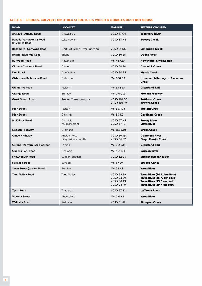
TABLE B – BRIDGES, CULVERTS OR OTHER STRUCTURES WHICH B-DOUBLES MUST NOT CROSS
ROAD LOCALITY MAP REF. FEATURE CROSSED
Ararat-St.Arnaud Road Crowlands VCSD 57 C4 Wimmera River
Benalla-Yarrawonga Road (St.James Road)
Lake Rowan VCSD 33 H6 Boosey Creek
Benambra–Corryong Road North of Gibbo River Junction VCSD 51 D5 Exhibition Creek
Bright–Tawonga Road Bright VCSD 50 B5 Ovens River
Burwood Road Hawthorn Mel 45 A10 Hawthorn–Lilydale Rail
Clunes–Creswick Road Clunes VCSD 58 E6 Creswick Creek
Don Road Don Valley VCSD 80 B5 Myrtle Creek
Gisborne–Melbourne Road Gisborne Mel 678 D3 Unnamed tributary off Jacksons Creek
Glenferrie Road Malvern Mel 59 B10 Gippsland Rail
Grange Road Burnley Mel 2H G12 Monash Freeway
Great Ocean Road Skenes Creek Wongara VCSD 101 D5 VCSD 101 D5
Petticoat Creek Browns Creek
High Street Melton Mel 337 D8 Toolern Creek
High Street Glen Iris Mel 59 K9 Gardiners Creek
McKillops Road Deddick Wulgulmerang
VCSD 67 H3 VCSD 67 F2
Snowy River Little River
Nepean Highway Dromana Mel 151 C10 Brokil Creek
Omeo Highway Anglers Rest Bingo Munjie North
VCSD 50 J9 VCSD 66 B2
Cobungra River Bingo Munjie Creek
Orrong-Malvern Road Corner Toorak Mel 2M G11 Gippsland Rail
Queens Park Road Geelong Mel 451 D4 Barwon River
Snowy River Road Suggan Buggan VCSD 52 G9 Suggan Buggan River
St Kilda Street Elwood Mel 67 D4 Elwood Canal
Swan Street (Wallen Road) Burnley Mel 22 A2 Yarra River
Tarra Valley Road Tarra Valley VCSD 98 B9 VCSD 98 B9 VCSD 98 A9 VCSD 98 A9
Tarra River (14.91 km Post) Tarra River (15.77 km post) Tarra River (19.2 km post) Tarra River (19.7 km post)
Tyers Road Traralgon VCSD 97 4J La Trobe River
Victoria Street Abbotsford Mel 2H H2 Yarra River
Walhalla Road Walhalla VCSD 81 J9 Stringers Creek

7
TABLE C – APPROVED MUNICIPAL ROADS
MUNICIPALITY APPROVED ROADS WHERE B-DOUBLES MUST NOT TRAVEL
Buloke All roads, if transporting farm related produce or materials.
� Any road, if transporting a load other than farm related produce and materials.
Campaspe All roads except those in column 3. � Any section of a road in Moama, Rushworth or Stanhope where the speed limit is 80 km/h or less
� Any section of a road in Echuca, Kyabram, Rochester, or Tongala where the speed limit is 80 km/h or less unless the road is listed in Table D;
� Bamawm Hall Road, between Prairie–Rochester Road and Singer Road;
� Bamawm Road, between Prairie–Rochester Road and Middleton Road;
� Bangerang Road, between Looker Road and municipal boundary;
� Barnadown–Myola Road, between Barnadown–Knowsley Road and Muskerry East School Road;
� Bennett Road, between Echuca–Nanneella Road and Gibson Road;
� Benson Road, between Lady Augusta Road and Simmie Road;
� Blamey Road, between Ronan Road and Geodetic Road;
� Carroll Road;
� Channel Inlet Road;
� Colbinabbin–Elmore Road, between Northern Highway and Bendigo–Murchison Road;
� Connally Lane;
� Davey Road, between Egans Bridge Road and Heathcote –Moora Road;
� Dehne Road;
� Dunbar Road, between South Boundary Road and Lilford Road;
� Everard Road, between Gibson Road and Thornton Road;
� Fox Island Road;
� Gibson Road, between Zegelin Road and Graham Road;
� Gledhill Road;
� Graham Road, between Trevaskis Road and Bolitho Road;
� Griffin Road, between Henderson Road and Day Road;
� Grogan Road, between Bendigo–Murchison Road and Colbinabbin–Elmore Road;
� Hagan Lane;
� Hansen Road, between Dullard Road and Lowe Road;
� Johnson Road, between Prairie–Rochester Road and Pannoo Road;
� Johnson Road, between Strathallan Road and Whinfield Road;
� Joyces Bridge Road;
� Laurie Road;
� Leitchville South Road;
� Lowrie Road, between Dullard Road and Bamawm Road;
� Middleton Road, between Lockington Road and Dullard Road;
� Morrisey Road, between Curr Road and McColl Road;
� Murphy Road, between Wilson Road and Griffin Road;

8
MUNICIPALITY APPROVED ROADS WHERE B-DOUBLES MUST NOT TRAVEL
Campaspe All roads except those in column 3. � O’Sullivan Road;
� Peter McEvoy Road;
� Point Road;
� River Road, between Barnadown–Knowsley Road and Bendigo–Murchison Road;
� Rushworth–Tatura Road, between Rushworth and municipal boundary;
� Russells Bridge Road, between Barnadown–Knowsley Road and municipal boundary;
� Simmie Road, between McKenzie Road and Rowe Road;
� Sinclair Road, between Goddard Road and municipal boundary;
� South Boundary Road, between Dunbar Road and Bolitho Road;
� Spiers Road, between Echuca–Mitiamo Road and Northern Highway;
� Splatt Road;
� Strathallan Road, between Northern Highway and Anderson Road;
� Strathallan Road, between Dullard Road and O’Brien Road;
� Tehan Road, between McKenzie Road and Graham Road;
� Thompsons Bridge Road, between Munzel Road and municipal boundary;
� Travaskis Road, between Lancaster Road and Matheson Road;
� White Road, between Curr Road and Henderson Road;
� Wilson Road, between Scobie Road and John Allan Road; and
� Zegelin Road, between Christie Road and Doherty Road.
Glenelg All roads except those in column 3. � Mocamboro Road, between north-west of swimming pool entrance and Portland–Casterton Road, Merino; and
� Any section of a road within the town of Digby or Nelson where the speed limit is 80 km/h or less,
� Any section of a road within the town of Casterton, Dartmoor, Heywood, Merino, Portland or Sandford where the speed limit is 80 km/h or less unless the road is listed in Table D.
Horsham All roads except those in column 3. � Rileys Road, between the Western Highway and Geodetic Road (no travel over the Horsham and Dimboola railway line); and
� Any section of a road where the speed limit is 80 km/h or less, unless the road is listed in Table D and is in the city of Horsham.
Mildura All roads.
West Wimmera All roads except those in column 3. � Any unsealed roads for any purpose other than pick-up or delivery of goods from a property on that road.
Yarriambiak All roads are approved.

9
TABLE D– APPROVED MUNICIPAL ROADS
APPROVED ROADS SECTION LOCALITY MUNICIPALITY REFERENCE
Abattoir Road For 660 metres west of Lake Road
Stawell Northern Grampians VCSD Map 550 B7
Abbott Road Hallam Casey Mel Map 96 D1
Abbott Street No exit directly onto Mt Napier Road - use Apex Drive
Hamilton Southern Grampians VCSD Map 506 H8
Abbotts Road ^ Dandenong South Greater Dandenong Mel Map 95 H8
Abel Street Golden Square Greater Bendigo VCSD Map 607 R9
Ackerly Avenue Benalla Benalla VCSD Map 663 O5
Adrian Road Campbellfield Hume Mel Map 7 G3
Advantage Drive Dandenong South Greater Dandenong Mel Map 95 G4
Aerodrome Road Ararat Ararat VCSD Map 56 H6
Agra Street North Shore Greater Geelong Mel Map 432 D11
Ainslie Road Campbellfield Hume Mel Map 180 F11
Aireys Street Between Colac- Lavers Hill Road and Forest Street
Colac Colac Otway VCSD Map 520 E8
Airfield Road Traralgon Latrobe VCSD Map 97 J5
Airlie Bank Road East Between Garden Street and Alexanders Road (Maryvale Road)
Morwell Latrobe VCSD Map 699 T4
Airport Road ^ Between Murray Valley Highway and Kerang-Koondrook Road
Kerang Gannawarra VCSD Map 592 D7
Ajax Road Altona Hobsons Bay Mel Map 54 A8
Albacutya Road ^ Albacutya Hindmarsh VCSD Map 16 H6
Albemarle Street Williamstown North Hobsons Bay Mel Map 55 D6
Albert Street Moolap Greater Geelong Mel Map 453 D9
Albert Street Warrnambool Warrnambool VCSD Map 514 F5
Albertson Road Barnawartha North Wodonga VCSD Map 35 D3
Albion Road Between O’Regan Street and Leviathan Road
Stawell Northern Grampians VCSD Map 550 J9
Alexandersons Road Between Hume Freeway and Avenel-Longwood Road
Locksley Strathbogie VCSD Map 46 G7
Alfred Street For 400 metres from Korumburra-Warragul Road (Howitt Street)
Warragul Baw Baw VCSD Map 704 G7
Alfred Street ^ Between Grano Street and High Street
Ararat Ararat VCSD Map 554 J7
Alick Road Tottenham Maribyrnong Mel Map 41 C6
Allansford- Wangoom Road
Allansford Moyne VCSD Map 90 B7
Allanvale Road Between Western Highway and Tuckers Hill Road
Great Western Northern Grampians VCSD Map 56 G4
Allendale- Kingston Road
Kingston Hepburn VCSD Map 58 H7

10
APPROVED ROADS SECTION LOCALITY MUNICIPALITY REFERENCE
Allies Road ^ Myers Flat Greater Bendigo VCSD Map 602 F7
Allingham Street Between Oak Street and Ham Street
Golden Square Greater Bendigo VCSD Map 607 N12
Alstonvale Court East Bendigo Greater Bendigo VCSD Map 608 F4
Amanda Avenue Morwell Latrobe VCSD Map 699 S6
Amanda Road Tottenham Maribyrnong Mel Map 41 B5
Amay Crescent Ferntree Gully Knox Mel Map 73 J3
Amayla Crescent Carrum Downs Frankston Mel Map 100 C4
Amcor Way Campbellfield Hume Mel Map 7 G1
Amsted Road Bayswater Knox Mel Map 64 K4
Anakie Road Between Cox Road and Geelong-Ballan Road
Lovely Banks Greater Geelong Mel Map 420 G7
Anchor Drive Wendouree Ballarat VCSD Map 562 C11
Anderson Road West Melbourne Port of Melbourne Corporation Mel Map 42 H8
Andersons Road Leongatha South Gippsland VCSD Map 710 A11
Andrews Lane Between Sandhills Road and Mortlake- Ararat Road
Willaura North Ararat VCSD Map 56 D8
Annandale Road Between South Centre Road and the western end of 60 Annandale Road
Tullamarine Hume Mel Map 15 C2
Anomaly Street Moolap Greater Geelong Mel Map 453 D9
Antwerp-Woorak Road Antwerp Hindmarsh VCSD Map 25 G6
Anzac Road Springhurst Wangaratta VCSD Map 34 J5
Apac Drive Melbourne Airport Melbourne Airport Mel Map 5 C7
Apex Drive Hamilton Southern Grampians VCSD Map 506 H8
Apollo Drive Hallam Casey Mel Map 96 F3
Apollo Drive Shepparton Greater Shepparton VCSD Map 673 T5
Appleton Dock Road ^ West Melbourne Port of Melbourne Corporation Mel Map 42 J8
Appleton Dock Link Road
West Melbourne Port of Melbourne Corporation Mel Map 42 J8
Archbolds Lane Tyers Latrobe VCSD Map 97 J4
Archer Street Between Midland Highway and Byass Street
Shepparton Shepparton VCSD 673 Q9
Ardmona Road Between Echuca-Mooroopna Road and Midland Highway
Ardmona Greater Shepparton VCSD Map 32 F8
Argyle Street North Service Road
Between Peterkin Street and McMahon Street (Traralgon-Maffra Road)
Traralgon Latrobe VCSD Map 697 L5
Argyle Street South Service Road
Between McNairn Road and Peterkin Street
Traralgon Latrobe VCSD Map 697 L5
Ari Drive Campbellfield Hume Mel Map 7 J5
Arkwright Drive Dandenong North Greater Dandenong Mel Map 94 J4
Ascot Street ^ Between Greenham Street and Lindsay Road
Dartmoor Glenelg VCSD Map 501 M4
Ash Street Avenel Strathbogie VCSD Map 677 S6

11
APPROVED ROADS SECTION LOCALITY MUNICIPALITY REFERENCE
Atlantic Drive (formerly Rihanna Drive)
Keysborough Greater Dandenong Mel Map 94 G3
Austrak Drive Somerton Hume Mel Map 180 D8
Austral Place Hallam Casey Mel Map 96 D2
Australis Drive Derrimut Brimbank Mel Map 39 C5
Avalon Road Between McClelland Avenue and Dandos Road
Avalon Greater Geelong VCSD Map 93 H2
Avenel- Longwood Road
Between Alexandersons Road and Correll Street
Locksley Strathbogie VCSD Map 46 G7
Averys Road Eaglehawk Greater Bendigo VCSD Map 603 R9
Avoca-Bealiba Road For 955 metres north east of Sunraysia Highway to grain receival facility
Avoca Pyrenees VCSD Map 57 J2
Axedale - Goornong Road
Between Raglan Street and Huntly-Fosterville Road
Axedale Greater Bendigo VCSD Map 45 A6
Aylward Avenue Thomastown Whittlesea Mel Map 8 D11
Back Bolac Road Between Willaura-Wickliffe Road and Mortlake-Ararat Road
Willaura Ararat VCSD Map 74 E4
Back Creek Road Between Myrtleford-Yackandandah Road and Kirby Flat Road
Yackandandah Indigo VCSD Map 35 F7
Back Quarry Road For 800 metres south of Quarry Road
Lake Boga Swan Hill VCSD Map 20 B2
Backwater Road Between McMahon Drive and Station Street
Maffra Wellington VCSD Map 694 C7
Baddaginnie - Benalla Road
Between Midland Highway and Palmerston Street
Benalla Benalla VCSD Map 663 L7
Baillie Street Colac East Colac Otway VCSD Map 520 J3
Baines Crescent Between Surf Coast Highway and Beach Road
Torquay Surf Coast VCSD Map 527 P5
Baird Street Between Fay Street and Pyrenees Highway
Ararat Ararat VCSD Map 554 G7
Bald Hill Road Between Healesville-Koo-Wee-Rup Road and Seven Mile Road (Koo Wee Rup-Nar Nar Goon Road)
Pakenham Cardinia Mel Map 318 A12
Baldwin Plains Road Gre Gre Northern Grampians VCSD Map 41 H4
Baldwin Road Altona North Hobsons Bay Mel Map 54 E3
Ballantynes Road ^ Between Goulburn Street and Dargalong Road
Nagambie Strathbogie VCSD Map 678 K4
Ballinger Street Horsham Horsham VCSD Map 544 D10
Bangholme Road Between Perry Road and Hammond Road
Dandenong South Greater Dandenong Mel Map 95 A9
Barambogie Road Between Racecourse Road and Cadens Track
Chiltern Indigo VCSD Map 35 B4
Baranduda Drive Baranduda Wodonga VCSD Map 35 H4
12
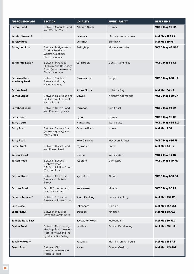
APPROVED ROADS SECTION LOCALITY MUNICIPALITY REFERENCE
Barbor Road Between Manuels Road and Whittles Track
Yallourn North Latrobe VCSD Map 97 H4
Barclay Crescent Hastings Mornington Peninsula Mel Map 154 J6
Barclay Road Derrimut Brimbank Mel Map 39 F1
Baringhup Road Between Bridgewater-Maldon Road and Central Goldfields Shire boundary
Baringhup Mount Alexander VCSD Map 43 G10
Baringhup Road ^ Between Pyrenees Highway and Boundary Road (Mount Alexander Shire boundary)
Carisbrook Central Goldfields VCSD Map 58 F2
Barnawartha - Howlong Road
Between Stanhope Street and Murray Valley Highway
Barnawartha Indigo VCSD Map 658 H9
Barnes Road Altona North Hobsons Bay Mel Map 54 H3
Barnes Street Between Lake Road and Scallan Street (Stawell-Avoca Road)
Stawell Northern Grampians VCSD Map 550 C7
Barrabool Road Between Devon Road and Princes Highway
Barrabool Surf Coast VCSD Map 93 D4
Barrs Lane ^ Flynn Latrobe VCSD Map 98 C5
Barry Court Wangaratta Wangaratta VCSD Map 664 B10
Barry Road Between Sydney Road (Hume Highway) and Merri Creek
Campbellfield Hume Mel Map 7 G4
Barry Road New Gisborne Macedon Ranges VCSD Map 636 F3
Barry Street Between Dorset Road and Power Road
Bayswater Knox Mel Map 64 H5
Bartley Street Moyhu Wangaratta VCSD Map 48 G3
Barton Road Between Echuca-Kyabram Road (McCormick Road) and Crichton Road
Kyabram Campaspe VCSD Map 599 M2
Barton Street Between Chambers Street and Mathew Street
Myrtleford Alpine VCSD Map 660 B4
Bartons Road For 1100 metres north of Rowans Road
Nullawarre Moyne VCSD Map 90 E9
Barwon Terrace ^ Between Swanston Street and Tucker Street
South Geelong Greater Geelong Mel Map 452 C9
Bate Close Pakenham Cardinia Mel Map 317 J11
Baxter Drive Between Industrial Drive and Jarrah Drive
Braeside Kingston Mel Map 88 A12
Bayfield Road East Bayswater North Maroondah Mel Map 50 J11
Bayliss Road Between Dandenong-Hastings Road (Western Port Highway) and the Lyndhurst Rail Siding
Lyndhurst Greater Dandenong Mel Map 95 H12
Bayview Road ^ Hastings Mornington Peninsula Mel Map 155 A6
Beach Road Between Old Melbourne Road and Pousties Road
Avalon Greater Geelong Mel Map 424 H4

13
APPROVED ROADS SECTION LOCALITY MUNICIPALITY REFERENCE
Beach Road Between Surf Coast Highway and Baines Crescent
Torquay Surf Coast VCSD Map 527 P5
Beaconsfield Parade ^ Between Gladstone Street and Old Hume Highway
Glenrowan Wangaratta VCSD Map 666 F10
Beatty Street North Shore Greater Geelong Mel Map 442 D1
Becks Bridge Road NORTH BOUND ONLY between Old Sale Road (Moe North Road) and Purvis Road
Newborough Latrobe VCSD Map 700 G1
Becks Bridge Road SOUTH BOUND ONLY from Purvis Road
Newborough Latrobe VCSD Map 97 F4
Becks Road Drysdale Greater Geelong Mel Map 458 B12
Becon Court Hallam Casey Mel Map 96 F1
Beischer Street Between Strickland Road and Fitt Court
East Bendigo Greater Bendigo VCSD Map 608 C5
Belcher Road Nhill Hindmarsh VCSD Map 546 D2
Bell Grove Between Lower Dandenong Road and Tarnard Drive
Braeside Kingston Mel Map 88 B8
Belle Vue Road Between Allingham Street and Sullivan Street
Golden Square Greater Bendigo VCSD Map 607 O10
Belle Vue Road Between Hattam Street (Golden Square- Quarry Hill Road) and Paterson Street
Quarry Hill Greater Bendigo VCSD Map 607 Q11
Bellellen Road Bellellen Northern Grampians VCSD Map 56 D4
Bellellen Road Pomonal Ararat VCSD Map 56 D4
Bena-Kongwak Road For 330 metres south of Fullers Way
Bena South Gippsland VCSD Map 96 E8
Benalla Boundary Road Between Midland Highway and Stewarton Road
Stewarton Benalla VCSD Map 33 E8
Benalla Road Between Benalla-Yarrawonga Road and Murray Valley Highway (Telford Street)
Yarrawonga Moira VCSD Map 668 C11
Benambra- Corryong Road
Between Murray Valley Highway and Dunstan Log Road
Colac Colac Towong VCSD Map 37 F6
Benambra- Limestone Road
For 200 metres north-east of King Street
Benambra East Gippsland VCSD Map 51 D9
Bendigo-Sutton Grange Road
From Calder Highway to City of Greater Bendigo Boundary
Sutton Grange Mount Alexander VCSD Map 59 G2
Benetook Avenue ^ Between Red Cliffs-Meringur Road and Calder Highway (Fifteenth Street)
Mildura Mildura VCSD Map 3 C6
Benjeroop- Tresco Road
Between Murray Valley Highway and Palmer Avenue
Tresco Swan Hill VCSD Map 14 D9
Benn Court Derrimut Brimbank Mel Map 39 B6
Bentley Street Williamstown North Hobsons Bay Mel Map 55 D7
14
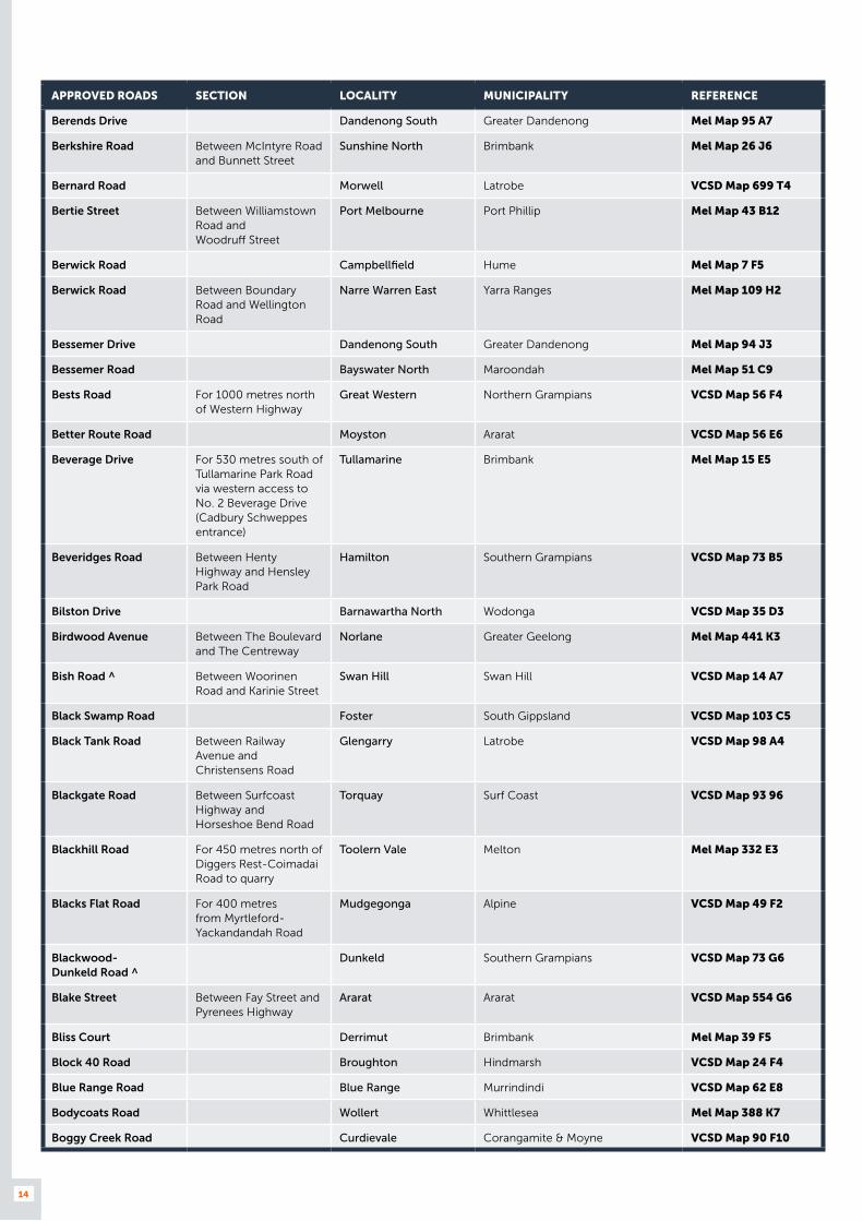
APPROVED ROADS SECTION LOCALITY MUNICIPALITY REFERENCE
Berends Drive Dandenong South Greater Dandenong Mel Map 95 A7
Berkshire Road Between McIntyre Road and Bunnett Street
Sunshine North Brimbank Mel Map 26 J6
Bernard Road Morwell Latrobe VCSD Map 699 T4
Bertie Street Between Williamstown Road and Woodruff Street
Port Melbourne Port Phillip Mel Map 43 B12
Berwick Road Campbellfield Hume Mel Map 7 F5
Berwick Road Between Boundary Road and Wellington Road
Narre Warren East Yarra Ranges Mel Map 109 H2
Bessemer Drive Dandenong South Greater Dandenong Mel Map 94 J3
Bessemer Road Bayswater North Maroondah Mel Map 51 C9
Bests Road For 1000 metres north of Western Highway
Great Western Northern Grampians VCSD Map 56 F4
Better Route Road Moyston Ararat VCSD Map 56 E6
Beverage Drive For 530 metres south of Tullamarine Park Road via western access to No. 2 Beverage Drive (Cadbury Schweppes entrance)
Tullamarine Brimbank Mel Map 15 E5
Beveridges Road Between Henty Highway and Hensley Park Road
Hamilton Southern Grampians VCSD Map 73 B5
Bilston Drive Barnawartha North Wodonga VCSD Map 35 D3
Birdwood Avenue Between The Boulevard and The Centreway
Norlane Greater Geelong Mel Map 441 K3
Bish Road ^ Between Woorinen Road and Karinie Street
Swan Hill Swan Hill VCSD Map 14 A7
Black Swamp Road Foster South Gippsland VCSD Map 103 C5
Black Tank Road Between Railway Avenue and Christensens Road
Glengarry Latrobe VCSD Map 98 A4
Blackgate Road Between Surfcoast Highway and Horseshoe Bend Road
Torquay Surf Coast VCSD Map 93 96
Blackhill Road For 450 metres north of Diggers Rest-Coimadai Road to quarry
Toolern Vale Melton Mel Map 332 E3
Blacks Flat Road For 400 metres from Myrtleford-Yackandandah Road
Mudgegonga Alpine VCSD Map 49 F2
Blackwood- Dunkeld Road ^
Dunkeld Southern Grampians VCSD Map 73 G6
Blake Street Between Fay Street and Pyrenees Highway
Ararat Ararat VCSD Map 554 G6
Bliss Court Derrimut Brimbank Mel Map 39 F5
Block 40 Road Broughton Hindmarsh VCSD Map 24 F4
Blue Range Road Blue Range Murrindindi VCSD Map 62 E8
Bodycoats Road Wollert Whittlesea Mel Map 388 K7
Boggy Creek Road Curdievale Corangamite & Moyne VCSD Map 90 F10

15
APPROVED ROADS SECTION LOCALITY MUNICIPALITY REFERENCE
Bolangum Inn Road Between Donald-Stawell Road and Wallaloo East Road
Marnoo Northern Grampians VCSD Map 41 G5
Bolangum Inn Road For 600 metres north west of Stawell- Avoca Road
Navarre Northern Grampians VCSD Map 42 C8
Bolgers Road From Tarra Valley Road to 400 metres west of Widdons Road
Devon North Wellington VCSD Map 104 C2
Bolinda Court Campbellfield Hume Mel Map 7 G8
Bonang Road (Scott Street)
Between Livingstone Street and Forest Road
Orbost East Gippsland VCSD Map 684 B7
Bonds Lane Hazelwood North Latrobe VCSD Map 97 H6
Boorhaman East Road Boorhaman Wangaratta VCSD Map 34 F5
Boorhaman Road ^ Killawarra Wangaratta VCSD Map 34 F6
Boralma- Tarrawingee Road
Londrigan Wangaratta VCSD Map 34 J7
Bormar Drive Pakenham Cardinia Mel Map 317 J11
Bosse Road For 400 metres west of Tongala Road to Nestle Factory
Tongala Campaspe VCSD Map 599 L10
Bosworth Road ^ Between Collins Street and Giles Street
Bairnsdale East Gippsland VCSD Map 688 E10
Bosworth Road Between MacArthur Street and Saleyard Road
Bairnsdale East Gippsland VCSD Map 688 J9
Boundary North Road Between Moglonemby Road and Graham Street
Euroa Strathbogie VCSD Map 677 O7
Boundary Road Between Fellmongers Road and Leather Street
Breakwater Greater Geelong Mel Map 466 G2
Boundary Road Between Robinsons Road and Mount Derrimut Road
Derrimut Brimbank Mel Map 39 A7
Boundary Road East of Fairbairn Road Sunshine West Brimbank Mel Map 40 D8
Boundary Road Between Timboon-Curdievale Road and Curdievale-Port Campbell Road
Timboon West Corangamite VCSD Map 90 G10
Boundary Road Wollert Whittlesea Mel Map 389 A8
Boundary Street East of Sugarloaf Road Corryong Towong VCSD Map 644 B6
Boundary Street Kerang Gannawarra VCSD Map 592 C7
Bourke Street Winchelsea Latrobe VCSD Map 696 H7
Bow Street ^ Rainbow Hindmarsh VCSD Map 545 T8
Bowers Road Between Hume Freeway and Winton-Glenrowan Road
Winton Benalla VCSD Map 48 C1
Bowlands Road ^ Leitchville Gannawarra VCSD Map 21 F8
Bowral Place Mitchell Park Ballarat VCSD Map 561 P9

16
APPROVED ROADS SECTION LOCALITY MUNICIPALITY REFERENCE
Boyd Road For 1000 metres west of Gundowring Road (no access further west due to load limited bridge at Kiewa River)
Kergunyah South Indigo VCSD Map 36 C8
Boyd Road For 750 metres from Kiewa Valley Highway
Gundowring Alpine VCSD Map 36 B8
Boys Road For 1000 metres north of Meeniyan-Promontory Road
Fish Creek South Gippsland VCSD Map 103 A4
Bradford Street Between Queen Street and the railway line
Wodonga Wodonga VCSD Map 653 P5
Bradys Lane Glengarry West Latrobe VCSD Map 98 A4
Braeside Drive Braeside Kingston Mel Map 88 A11
Braithwaite Street Between Walsh Road and Rooneys Road
Warrnambool Warrnambool VCSD Map 514 E5
Bramleys Road Guys Forest Towong VCSD Map 37 C3
Branch Road Little River Greater Geelong VCSD Map 77 H9
Brand Drive Thomastown Whittlesea Mel Map 9 D11
Brand Road Knoxfield Knox Mel Map 73 C7
Brazenor Street Delacombe Ballarat VCSD Map 565 R10
Breed Street Between Grey Street (Tyers Road) and Princes Street
Traralgon Latrobe VCSD Map 696 G6
Breen Street Between Russell Street and Freight Australia’s rail terminal
Quarry Hill Greater Bendigo VCSD Map 607 R8
Brewer Road Between Collie Road and McEwan Road
Byrneside Greater Shepparton VCSD Map 32 C8
Bridge Inn Road Wollert Whittlesea Mel Map 388 D8
Bridge Road Keysborough Greater Dandenong Mel Map 89 J8
Bridge Street North of Williamstown Road
Port Melbourne Port Phillip Mel Map 57 B1
Bridgewood Court Wantirna South Knox Mel Map 64 B11
Bridle Road Between Princes Drive and Chickerell Street
Morwell Latrobe VCSD Map 699 R5
Bridport Street Between Albert Street (Midland Highway) and Central Springs Road
Daylesford Hepburn VCSD Map 582 E10
Briggs Drive Derrimut Brimbank Mel Map 39 G6
Briggs Gap Road Between Hanson Street (Murray Valley Highway) and Stock Route
Corryong Towong VCSD Map 644 A3
Broderick Road Corio Greater Geelong Mel Map 432 F3
Brooklyn Court Campbellfield Hume Mel Map 7 F7
Broughton Road Broughton Hindmarsh VCSD Map 24 G4
Broughton- Kaniva Road
Broughton Hindmarsh VCSD Map 24 F4
Broughton-Yanac Road Yanac Hindmarsh VCSD Map 24 H4
Browning Street Between Learmonth Street and Henty Highway (Port Road)
Portland Glenelg VCSD Map 501 N10

17
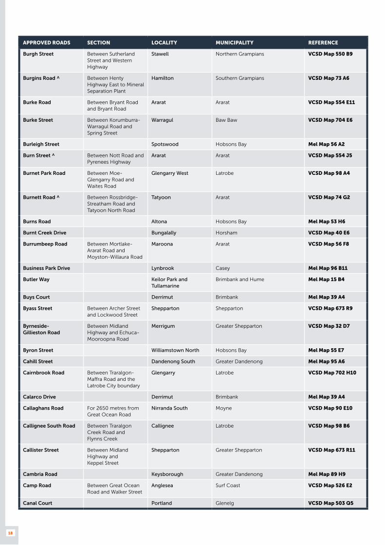
APPROVED ROADS SECTION LOCALITY MUNICIPALITY REFERENCE
Browning Street Wangaratta Wangaratta VCSD Map 664 A12
Browns Road Between Princes Highway and Summit Road
Noble Park North Greater Dandenong Mel Map 80 G10
Bruce Street Between Forest Street and railway line
Colac Colac Otway VCSD Map 520 H4
Brunel Road Seaford Frankston Mel Map 99 J2
Brunsdon Street Bayswater Knox Mel Map 64 J5
Bryant Road Between Port Fairy Road and Tatyoon Road
Ararat Ararat VCSD Map 554 E11
Bryants Gap Road For 3000 metres south of Murray Valley Highway
Tallangatta Towong VCSD Map 36 D5
Buangor- Ben Nevis Road
Between Western Highway and Iron Pot Creek Road
Warrak Ararat VCSD Map 57 D6
Bubb Street Moe Latrobe VCSD Map 700 D3
Buch Avenue Epping Whittlesea Mel Map 9 A2
Buchanan Road Brooklyn Hobsons Bay Mel Map 40 H11
Buchans Lane For 5620 metres west of Rossbridge-Streatham Road (to unnamed road locally known as Baleys Road)
Mininera Ararat VCSD Map 74 G3
Buckland Valley Road Between Great Alpine Road and Eggleston Lane
Porepunkah Alpine VCSD Map 49 G5
Buckley Grove Northbound only Moolap Greater Geelong Mel Map 453 H9
Buckleys Track Driffield Latrobe VCSD Map 97 G5
Buffalo River Road Between Lake Buffalo dam wall and Lake Buffalo-Whitfield Road
Buffalo River Alpine VCSD Map 49 C6
Buffalo-Waratah Road Between Buffalo-Tarwin Lower Road and Summers Road
Buffalo South Gippsland VCSD Map 102 J5
Builders Close Wendouree Ballarat VCSD Map 566 B1
Bulldog Drive Delacombe Ballarat VCSD Map 565 R11
Bullivant Street Wangaratta Wangaratta VCSD Map 664 E11
Bunbury Street Glenorchy Northern Grampians VCSD Map 551 T3
Buninyong- Mt. Mercer Road
Grenville Golden Plains VCSD Map 76 F6
Bunnett Street Between Berkshire Road and Palmer Tube Mills
Sunshine North Brimbank Mel Map 26 K6
Bunting Road ^ Brooklyn Brimbank Mel Map 41 A7
Bunyip-Modella Road ^ Between Nar Nar Goon Road and Bunyip River Road
Bunyip Cardinia VCSD Map 96 D3
Bunyip River Road Cora Lyn Cardinia VCSD Map 96 B4
Burdett Lane Wickliffe Ararat VCSD Map 74 D4
Burgess Road Bayswater North Maroondah Mel Map 51 A10
18
APPROVED ROADS SECTION LOCALITY MUNICIPALITY REFERENCE
Burgh Street Between Sutherland Street and Western Highway
Stawell Northern Grampians VCSD Map 550 B9
Burgins Road ^ Between Henty Highway East to Mineral Separation Plant
Hamilton Southern Grampians VCSD Map 73 A6
Burke Road Between Bryant Road and Bryant Road
Ararat Ararat VCSD Map 554 E11
Burke Street Between Korumburra-Warragul Road and Spring Street
Warragul Baw Baw VCSD Map 704 E6
Burleigh Street Spotswood Hobsons Bay Mel Map 56 A2
Burn Street ^ Between Nott Road and Pyrenees Highway
Ararat Ararat VCSD Map 554 J5
Burnet Park Road Between Moe-Glengarry Road and Waites Road
Glengarry West Latrobe VCSD Map 98 A4
Burnett Road ^ Between Rossbridge-Streatham Road and Tatyoon North Road
Tatyoon Ararat VCSD Map 74 G2
Burns Road Altona Hobsons Bay Mel Map 53 H6
Burnt Creek Drive Bungalally Horsham VCSD Map 40 E6
Burrumbeep Road Between Mortlake-Ararat Road and Moyston-Willaura Road
Maroona Ararat VCSD Map 56 F8
Business Park Drive Lynbrook Casey Mel Map 96 B11
Butler Way Keilor Park and Tullamarine
Brimbank and Hume Mel Map 15 B4
Buys Court Derrimut Brimbank Mel Map 39 A4
Byass Street Between Archer Street and Lockwood Street
Shepparton Shepparton VCSD Map 673 R9
Byrneside- Gillieston Road
Between Midland Highway and Echuca-Mooroopna Road
Merrigum Greater Shepparton VCSD Map 32 D7
Byron Street Williamstown North Hobsons Bay Mel Map 55 E7
Cahill Street Dandenong South Greater Dandenong Mel Map 95 A6
Cairnbrook Road Between Traralgon-Maffra Road and the Latrobe City boundary
Glengarry Latrobe VCSD Map 702 H10
Calarco Drive Derrimut Brimbank Mel Map 39 A4
Callaghans Road For 2650 metres from Great Ocean Road
Nirranda South Moyne VCSD Map 90 E10
Callignee South Road Between Traralgon Creek Road and Flynns Creek
Callignee Latrobe VCSD Map 98 B6
Callister Street Between Midland Highway and Keppel Street
Shepparton Greater Shepparton VCSD Map 673 R11
Cambria Road Keysborough Greater Dandenong Mel Map 89 H9
Camp Road Between Great Ocean Road and Walker Street
Anglesea Surf Coast VCSD Map 526 E2
Canal Court Portland Glenelg VCSD Map 503 Q5
19
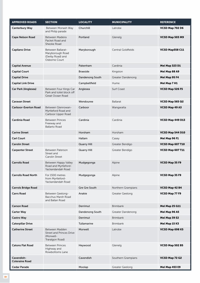
APPROVED ROADS SECTION LOCALITY MUNICIPALITY REFERENCE
Canterbury Way Between Monash Way and Philip parade
Churchill Latrobe VCSD Map 702 D6
Cape Nelson Road Between Madeira Packet Road and Sheoke Road
Portland Glenelg VCSD Map 503 M9
Capilano Drive Between Ballarat-Maryborough Road (Derby Road) and Osborne Court
Maryborough Central Goldfields VCSD Map558 C11
Capital Avenue Pakenham Cardinia Mel Map 323 D1
Capital Court Braeside Kingston Mel Map 88 A9
Capital Drive Dandenong South Greater Dandenong Mel Map 95 F4
Capital Link Drive Campbellfield Hume Mel Map 7 H1
Car Park (Anglesea) Between Four Kings Car Park and toilet block off Great Ocean Road
Anglesea Surf Coast VCSD Map 526 F5
Caravan Street Wendouree Ballarat VCSD Map 565 Q2
Carboor-Everton Road Between Glenrowan-Myrtleford Road and Carboor Upper Road
Carboor Wangaratta VCSD Map 49 A3
Cardinia Road Between Princes Freeway and Ballarto Road
Cardinia Cardinia VCSD Map 449 D13
Carine Street Horsham Horsham VCSD Map 544 D10
Carl Court Hallam Casey Mel Map 96 F1
Carolin Street Quarry Hill Greater Bendigo VCSD Map 607 T10
Carpenter Street Between Paterson Street and Carolin Street
Quarry Hill Greater Bendigo VCSD Map 607 T11
Carrolls Road Between Happy Valley Road and Myrtleford-Yackandandah Road
Mudgegonga Alpine VCSD Map 35 F9
Carrolls Road North For 1500 metres from Myrtleford-Yackandandah Road
Mudgegonga Alpine VCSD Map 35 F9
Carrols Bridge Road Gre Gre South Northern Grampians VCSD Map 42 B4
Carrs Road Between Geelong-Bacchus Marsh Road and Ballan Road
Anakie Greater Geelong VCSD Map 77 F9
Carson Road Derrimut Brimbank Mel Map 25 G11
Carter Way Dandenong South Greater Dandenong Mel Map 96 A5
Castro Way Derrimut Brimbank Mel Map 39 E2
Caterpillar Drive Tullamarine Brimbank Mel Map 15 K3
Catherine Street Between Madden Street and Princes Drive (Morwell- Traralgon Road)
Morwell Latrobe VCSD Map 698 K5
Catons Flat Road Between Princes Highway and Rowbottoms Lane
Heywood Glenelg VCSD Map 502 B5
Cavendish- Coleraine Road
Cavendish Southern Grampians VCSD Map 72 G2
Cedar Parade Moolap Greater Geelong Mel Map 453 E9

20
APPROVED ROADS SECTION LOCALITY MUNICIPALITY REFERENCE
Cemetery Road Between Geelong Road and Francis Street on the Hobsons Bay City Council side (west side).
Brooklyn Hobsons Bay Mel Map 41 D9
Cemetery Road Between Glenorchy Road and McKay Road (to silo)
Glenorchy Northern Grampians VCSD Map 551 U2
Cemetery Road Great Western Northern Grampians VCSD Map 56 F4
Cemetery Road Between Willaura-Wickliffe Road and Burdett Lane
Wickliffe Ararat VCSD Map 74 D4
Central Avenue Between Midland Highway and Dookie-Shepparton Road
Shepparton East Greater Shepparton VCSD Map 32 J8
Central Springs Road Between Bridport Street and Vincent Street (Ballan-Daylesford Highway)
Daylesford Hepburn VCSD Map 582 E10
Centre Road Between Hallam South Road and eastern access to Rimfire Drive
Hallam Casey Mel Map 96 H5
Centre Road Between Francis Briggs Road and Apac Drive
Melbourne Airport Hume Mel Map 5 C7
Centre Road Morwell Latrobe VCSD Map 699 T4
Centre Road Between Goulburn Valley Highway and Boals Road
Numurkah Moira VCSD Map 32 F2
Centre Way Croydon South Maroondah Mel Map 51 B8
Century Drive Between Industrial Drive and Malcolm Road
Braeside Kingston Mel Map 88 A12
Chalambar Road For 800 metres east from Mortlake-Ararat Road
Ararat Ararat VCSD Map 56 G6
Challicum Road Buangor Ararat VCSD Map 57 D8
Chambers Road Between Barnes Road and Ross Road
Altona North Hobsons Bay Mel Map 54 K4
Chambers Street Myrtleford Alpine VCSD Map 660 B4
Chambeyron Road For 452 metres east to the State Forest boundary
Stanley Indigo VCSD Map 35 E8
Chapel Street Lynbrook Casey Mel Map 96 B10
Chaplins Road ^ Between Pyrenees Highway and Dunach Eddington Road
Carisbrook Central Goldfields VCSD Map 557 P7
Chapple Street ^ Between Thomas Mitchel Drive and Victoria Cross Parade
Wodonga Wodonga VCSD Map 653 Q6
Charity Lane Foster South Gippsland VCSD Map 103 D4
Charleston Road Between Kennedy Street and Nolan Street
Bendigo Greater Bendigo VCSD Map 607 U5
Charlesworth Street Between Fussell Street and Stawell Street South
Ballarat East Ballarat VCSD Map 566 J9
Chatsworth- Lake Bolac Road
Lake Bolac Ararat VCSD Map 74 E6

21
APPROVED ROADS SECTION LOCALITY MUNICIPALITY REFERENCE
Chatsworth- Wickliffe Road
Wickliffe Ararat VCSD Map 74 C7
Chelmsford Street Williamstown North Hobsons Bay Mel Map 55 D6
Cherry Lane Laverton North Wyndham Mel Map 54 A2
Chickerell Street Morwell Latrobe VCSD Map 699 S5
Chifley Drive Between Bell Street and Dundas Street
Preston Darebin Mel Map 31 B4
Childers- Thorpdale Road
Between Mirboo North-Trafalgar Road and McDonalds Track
Thorpdale Baw Baw VCSD Map 97 D6
Chiltern- Barnawartha Road
Barnawartha Indigo VCSD Map 658 F12
Chinamans Lane ^ Tungamah Moira VCSD Map 33 F4
Chinkapook- Nyah West Road ^
Includes Monash Avenue
Nyah West Swan Hill VCSD Map 13 G4
Chintin Road Between rear entrance of gravel pit and Melbourne- Lancefield Road
Monegeetta Macedon Ranges VCSD Map 60 E8
Christensen Lane Wangaratta Wangaratta VCSD Map 664 A5
Christensens Road Glengarry Latrobe VCSD Map 98 A4
Christensens Road Tyers Latrobe VCSD Map 97 J4
Christies Road Between Western Highway and Palm Springs Road
Ravenhall Melton Mel Map 358 G5
Christmas Street Between Sparks Avenue and Grange Road
Fairfield Darebin Mel Map 31 A7
Chuggs Road Between Cohuna-Leitchville Road and Danahers Road
Cohuna Gannawarra VCSD Map 21 E7
Church Road Between Maryvale Road and Hazelwood Road (Churchill- Traralgon Road)
Hazelwood North Latrobe VCSD Map 97 J6
Church Street Between Princes Highway (Princes Street) and Grey Street (Tyers Road)
Traralgon Latrobe VCSD Map 696 H6
Church Street Between South Street and Bond Street
Wodonga Wodonga VCSD Map 653 N5
Church Street ^ Between Vines Road and Midland Highway, but not on school days between 8.00am and 9.30am, or between 2.30pm and 4.00pm
Hamlyn Heights Greater Geelong Mel Map 441 F11
Churchill Avenue Between Great Alpine Road and Morses Creek Road
Bright Alpine VCSD Map 661 S6
Churchill Street Williamstown North Hobsons Bay Mel Map 55 E7
Citrus Street Braeside Kingston Mel Map 88 A4
Clancys Lane Woodend Macedon Ranges VCSD Map 60 A7
Clare Street Bayswater Knox Mel Map 64 J4
Claredale Road Dandenong Greater Dandenong Mel Map 90 G11

22
APPROVED ROADS SECTION LOCALITY MUNICIPALITY REFERENCE
Clark Street Between Maryborough-Dunolly Road and Desmond Street
Dunolly Central Goldfields VCSD Map 559 S5
Clarkes Road Between Sanders Road and Hazelwood Road
Hazelwood North Latrobe VCSD Map 98 A6
Clarkes Road Between Loy Yang-Morwell Road and Hazelwood Road
Traralgon Latrobe VCSD 98 A6
Cleaves Road Between Murray Valley Highway and Cohuna Island Road
Cohuna Gannawarra VCSD Map 21 F7
Cliff Street (Link Road) Between Henty Highway (Port Road) and Canal Court
Portland Glenelg VCSD Map 503 R5
Clift Court Altona North Hobsons Bay Mel Map 54 F3
Cliveden Court Thomastown Whittlesea Mel Map 8 K9
Coal Court Morwell Latrobe VCSD Map 699 O8
Coalmine Road Between Great Ocean Road and Camp Road
Anglesea Surf Coast VCSD Map 93 E8
Cobains Road Between Somerton Park Road and Princes Highway
Sale Wellington VCSD Map 693 P2
Cobb Court Swan Hill Swan Hill VCSD Map 586 F1
Coburn Road Streatham Ararat VCSD Map 75 B3
Cochranes Road For 2000 metres from Drouin-Korumburra Road
Poowong North South Gippsland VCSD Map 96 D6
Cochranes Road Between Mattingley Hill Road and Phelan Lane
Traralgon South Latrobe VCSD Map 98 A6
Coghills Road For 2000 metres west of Murray Valley Highway
Berringama Towong VCSD Map 37 C4
Coghlans Road For 200 metres east of Caramut Road from Rooneys Road
Dennington Warrnambool VCSD Map 514 F1
Cohuna Island Road Between Murray Valley Highway and Cleaves Road
Cohuna Gannawarra VCSD Map 21 F7
Cohuna- Leitchville Road
East from Leitchville-Kerang Road to Murray Valley Highway
Leitchville Gannawarra VCSD Map 21 F7
Cohuna- McMillans Road
Between Greens Road and Cohuna- Leitchville Road
Cohuna Gannawarra VCSD MAP 590 G11
Coker Dam Road Gerang Gerung Hindmarsh VCSD Map 25 F8
Colbert Road Campbellfield Hume Mel Map 7 G5
Colemans Road Carrum Downs Frankston Mel Map 100 C1
Colemans Road Between Dandenong-Frankston Road and Produce Drive
Dandenong South Greater Dandenong Mel Map 95 D10
Colling Court Long Gully Greater Bendigo VCSD Map 607 O2
Collins Street Bairnsdale East Gippsland VCSD Map 688 D10
Collins Street Between Fairview Road and Olympic Parade
Kangaroo Flat Greater Bendigo VCSD Map 612 G1
23
APPROVED ROADS SECTION LOCALITY MUNICIPALITY REFERENCE
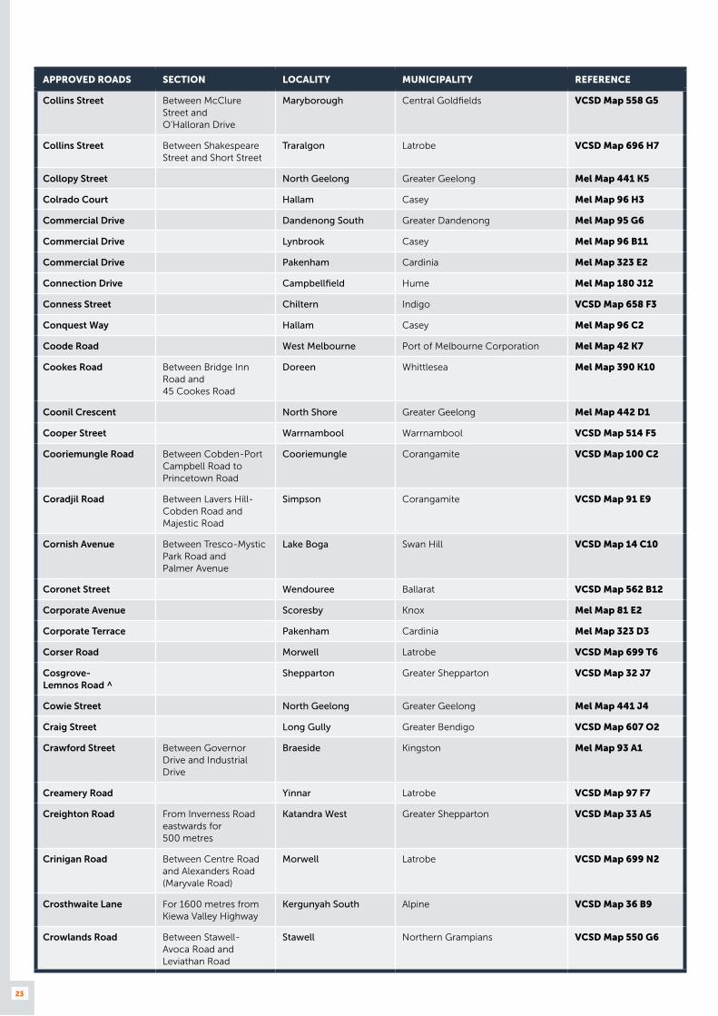
Collins Street Between McClure Street and O’Halloran Drive
Maryborough Central Goldfields VCSD Map 558 G5
Collins Street Between Shakespeare Street and Short Street
Traralgon Latrobe VCSD Map 696 H7
Collopy Street North Geelong Greater Geelong Mel Map 441 K5
Colrado Court Hallam Casey Mel Map 96 H3
Commercial Drive Dandenong South Greater Dandenong Mel Map 95 G6
Commercial Drive Lynbrook Casey Mel Map 96 B11
Commercial Drive Pakenham Cardinia Mel Map 323 E2
Connection Drive Campbellfield Hume Mel Map 180 J12
Conness Street Chiltern Indigo VCSD Map 658 F3
Conquest Way Hallam Casey Mel Map 96 C2
Coode Road West Melbourne Port of Melbourne Corporation Mel Map 42 K7
Cookes Road Between Bridge Inn Road and 45 Cookes Road
Doreen Whittlesea Mel Map 390 K10
Coonil Crescent North Shore Greater Geelong Mel Map 442 D1
Cooper Street Warrnambool Warrnambool VCSD Map 514 F5
Cooriemungle Road Between Cobden-Port Campbell Road to Princetown Road
Cooriemungle Corangamite VCSD Map 100 C2
Coradjil Road Between Lavers Hill-Cobden Road and Majestic Road
Simpson Corangamite VCSD Map 91 E9
Cornish Avenue Between Tresco-Mystic Park Road and Palmer Avenue
Lake Boga Swan Hill VCSD Map 14 C10
Coronet Street Wendouree Ballarat VCSD Map 562 B12
Corporate Avenue Scoresby Knox Mel Map 81 E2
Corporate Terrace Pakenham Cardinia Mel Map 323 D3
Corser Road Morwell Latrobe VCSD Map 699 T6
Cosgrove- Lemnos Road ^
Shepparton Greater Shepparton VCSD Map 32 J7
Cowie Street North Geelong Greater Geelong Mel Map 441 J4
Craig Street Long Gully Greater Bendigo VCSD Map 607 O2
Crawford Street Between Governor Drive and Industrial Drive
Braeside Kingston Mel Map 93 A1
Creamery Road Yinnar Latrobe VCSD Map 97 F7
Creighton Road From Inverness Road eastwards for 500 metres
Katandra West Greater Shepparton VCSD Map 33 A5
Crinigan Road Between Centre Road and Alexanders Road (Maryvale Road)
Morwell Latrobe VCSD Map 699 N2
Crosthwaite Lane For 1600 metres from Kiewa Valley Highway
Kergunyah South Alpine VCSD Map 36 B9
Crowlands Road Between Stawell- Avoca Road and Leviathan Road
Stawell Northern Grampians VCSD Map 550 G6

24
APPROVED ROADS SECTION LOCALITY MUNICIPALITY REFERENCE
Crown Street South Geelong Greater Geelong Mel Map 452 C9
Crows Road Between Barwon Heads Road and the Belmont Timber
Belmont Greater Geelong Mel Map 465 K2
Culgoa-Ultima Road Between Sea Lake-Swan Hill Road and Swan Hill Rural City Council boundary (Lalbert Creek)
Lake Boga Swan Hill VCSD Map 13 E10
Cummins Drive Somerton Hume Mel Map 180 E7
Cumnock Road Between Lalbert Road and Quarry Road
Lake Boga Swan Hill VCSD Map 588 J4
Curdievale-Port Campbell Road
Between Timboon-Curdievale Road and Great Ocean Road
Lower Heytesbury Corangamite VCSD Map 100 A3
Curtis Road Belmont Greater Geelong Mel Map 451 K12
Cusack Road Leongatha South Gippsland VCSD Map 710 E7
Cypress Street Between Lake Road and Haughton Street
Stawell Northern Grampians VCSD Map 550 C7
Dalmahoy Street Between Ligar Street and MacArthur Street
Bairnsdale East Gippsland VCSD Map 688 H9
Damms Road For 1200 metres from Mountain Creek Road
Tawonga Alpine VCSD Map 50 D5
Damosh Avenue Carrum Downs Frankston Mel Map 100 B2
Danahers Road From Chuggs Road to the end of the sealed section of road
Cohuna Gannawarra VCSD Map 21 E7
Dandos Road Between Avalon Road and Mountain View Quarry entrance
Avalon Greater Geelong VCSD Map 93 J2
Dansu Court Hallam Casey Mel Map 96 C1
Darbyshire Street Williamstown North Hobsons Bay Mel Map 55 C7
Darlimurla Road Between Todds Road and Old Darlimurla Road
Boolarra Latrobe VCSD Map 97 E7
Darling Street Between Skipton Street and Sergeants Lane
Redan Ballarat VCSD Map 566 A11
Darlington-Carranballac Road ^
Pura Pura Ararat VCSD Map 75 D5
Darts Road ^ Between School Road and Henty Highway
Portland Glenelg VCSD Map 501 N8
Davey Street Morwell Latrobe VCSD Map 698 K5
Daveyduke Drive Mitchell Park Ballarat VCSD Map 561 P9
David Lee Road Hallam Casey Mel Map 96 F2
David Street ^ Robinvale Swan Hill VCSD Map 587 Q4
Davis Avenue ^ Between Western Highway and Whitehead Avenue
Nhill Hindmarsh VCSD Map 546 D2
Davis Court Derrimut Brimbank Mel Map 39 G1
Davis Street Ferntree Gully Knox Mel Map 73 J4
Day Avenue Omeo East Gippsland VCSD Map 690 H9

25
APPROVED ROADS SECTION LOCALITY MUNICIPALITY REFERENCE
Dead Horse Lane Between Midland Highway and Mansfield-Whitfield Road
Mansfield Mansfield VCSD Map 679 N2
Deakin Street Traralgon Latrobe VCSD Map 696 H6
Deans Road Driffield Latrobe VCSD Map 97 G5
Deborah Street Golden Square Greater Bendigo VCSD Map 612 H1
Decco Court Campbellfield Hume Mel Map 7 F7
Decor Drive Hallam Casey Mel Map 96 E1
Delacombe Way ^ Between Willaura-Wickliffe Road and Rossbridge-Streatham Road
Willaura Ararat VCSD Map 74 E2
Della Torre Road Moe Latrobe VCSD Map 700 D3
Dempster Street Ferntree Gully Knox Mel Map 73 J4
Denbigh Street Moolap Greater Geelong Mel Map 453 E9
Dendle Street Grovedale Greater Geelong Mel Map 465 J5
Dennis Street Campbellfield Hume Mel Map 180 C10
Depot Road Between Down Street and Hume Freeway
Longwood Strathbogie VCSD Map 46 H6
Derrimut Drive Derrimut Brimbank Mel Map 39 A6
Desmond Street Between Clarke Street and Thompson Street
Dunolly Central Goldfields VCSD Map 559 S4
Detour Road North Wangaratta Wangaratta VCSD Map 34 G7
Development Boulevard
Between Plenty Road and Heaths Court
Mill Park Whittlesea Mel Map 10 D1
Dhurringile Road ^ Between Midland Highway and Punt Road
Tatura Greater Shepparton VCSD Map 671 P4
Diamond Drive Sunshine West Brimbank Mel Map 40 G7
Diapur-Miriam Road ^ Between Nhill-Diapur Road and West Wimmera Shire boundary
Diapur Hindmarsh VCSD Map 24 H7
Diapur-Yanac Road ^ Between Nhill-Diapur Road and O’Reillys Road
Bleak House Hindmarsh VCSD Map 24 J6
Dickson Street Warrnambool Warrnambool VCSD Map 514 E5
Diffey Road Between Bridge Street (Beechworth-Wangaratta Road) and Davidson Lane
Beechworth Indigo VCSD Map 659 M7
Diffey Road Between White Post Road and quarry entrance
Everton Wangaratta VCSD Map 35 A8
Diggers Parade For 70 metres south-west of Great Ocean Road
Anglesea Surf Coast VCSD Map 526 E4
Dillon Street Between Karook Street and Broadway Street (Barooga Road)
Cobram Moira VCSD Map 667 N8

26
APPROVED ROADS SECTION LOCALITY MUNICIPALITY REFERENCE
Dimboola-Minyip Road Between Borung Highway (Dimboola-Warracknabeal Road) and Yarriambiack Shire boundary
Dimboola Hindmarsh VCSD Map 26 C8
Dingley Dell Road For 3000 metres from Mirboo North-Trafalgar Road
Thorpdale Baw Baw VCSD Map 97 D7
Discovery Road Dandenong South Greater Dandenong Mel Map 95 E11
Dock Link Road ^ South of Footscray Rd is POM, North is Arterial
West Melbourne Port of Melbourne Corporation Mel Map 42 G6
Docklands Drive Formerly Dudley Street south of Footscray Road
Docklands Melbourne Mel Map 2E B4
Dockside Road Port Melbourne Port of Melbourne Corporation Mel Map 56 F3
Dodd Court Traralgon East Latrobe VCSD Map 697 N3
Doherty Street Pakenham Cardinia Mel Map 215 K4
Doherty’s Road Between Fitzgerald Road and Palmers Road
Laverton North Wyndham Mel Map 39 A11
Donaldson Street Between Hanson Street (Murray Valley Highway) and municipal saleyards
Corryong Towong VCSD Map 644 D2
Dorset Road Service Road
Bayswater Knox Mel Map 64 K5
Douglas Street Colac Colac Otway VCSD Map 520 H4
Douro Street ^ North Geelong Greater Geelong Mel Map 441 J8
Dowling Street Wendouree Ballarat VCSD Map 566 B12
Down Street Between Hill Street and Depot Road
Longwood Strathbogie VCSD Map 46 H6
Downard Street Braeside Kingston Mel Map 88 A9
Downes Road Castlemaine Mount Alexander VCSD Map 628 G4
Dowsett Street South Geelong Greater Geelong Mel Map 452 D9
Dream Haven Court Epping Whittlesea Mel Map 181 K10
Drovers Place Pakenham Cardinia Mel Map 323 G2
Drummond Road Shepparton Greater Shepparton VCSD Map 673 S8
Drummond Street Between Tylden Street and Lindsay Street
Dennington Warrnambool VCSD Map 514 C2
Dunbar Road Traralgon Latrobe VCSD Map 696 H8
Dundas Street East of Albert Street Preston Darebin Mel Map 31 A4
Dundas Street St Arnaud Northern Grampians VCSD Map 551 S10
Dunnstown- Yendon Road
Dunnstown Moorabool VCSD Map 76 H3
Dunolly-Avoca Road Between Separation Road and Pyrenees Shire Boundary
Dunolly Central Goldfields VCSD Map 559 Q6
Dunolly- Inglewood Road
For 1500 metres south of Weeah Street to the abattoirs
Inglewood Loddon VCSD Map 594 C5
Dyrings Road Foster South Gippsland VCSD Map 103 D4
East Derrimut Crescent Derrimut Brimbank Mel Map 39 A6
Eastern Road Traralgon East Latrobe VCSD Map 697 M4

27
APPROVED ROADS SECTION LOCALITY MUNICIPALITY REFERENCE
Eastern Road Yallourn Latrobe VCSD Map 97 G4
Eastgate Court Wantirna South Knox Mel Map 64 B12
Eastwood Road Bairnsdale East Gippsland VCSD Map 688 J1
Eddy Street Hamilton Southern Grampians VCSD Map 506 H7
Edelmaier Street Bayswater Knox Mel Map 64 H5
Edgar Street Between Tatura-Undera Road and Park Street
Tatura Greater Shepparton VCSD Map 671 M3
Edi-Cheshunt Road Cheshunt Wangaratta VCSD Map 48 H6
Edols Street North Geelong Greater Geelong Mel Map 441 K5
Edwardes Street Between Radford Road and Plateau Road
Reservoir Darebin Mel Map 18 C5
Edwards Road Between Sheathers Road and Cochranes Road
West Wodonga Wodonga VCSD Map 652 E2
Egglestons Lane Between Buckland Valley Road and the pine plantation
Buckland Alpine VCSD Map 49 G5
Elata Drive For 175 metres south of Tullamarine Park Road to No. 1 Elata Drive
Tullamarine Brimbank Mel Map 15 D5
Electra Avenue Morwell Latrobe VCSD Map 699 O8
Elgar Road Derrimut Brimbank Mel Map 39 E2
Elgin Boulevard Between House Creek and Watson Street
Wodonga Wodonga VCSD Map 653 L5
Elgin Road Between High Street and Red Hill Road
Beechworth Indigo VCSD Map 659 Q4
Elizabeth Street Between Mortlake-Ararat Road and Gordon Street
Ararat Ararat VCSD Map 554 F10
Elkington Road Between McKoy Street and Lewington Street
West Wodonga Wodonga VCSD Map 652 D3
Ellam- Willenabrina Road ^
Between Dimboola-Jeparit Road and McKenzie Road
Willenabrina Hindmarsh VCSD Map 26 D3
Ellerman Street ^ Between Dimboola-Rainbow Road and Borung Highway (Dimboola-Warracknabeal Road)
Dimboola Hindmarsh VCSD Map 546 G8
Ellerslie-Panmure Road Between Terang-Framlingham Road and High Street
Framlingham Moyne VCSD Map 90 D6
Elliott Road Dandenong South Greater Dandenong Mel Map 95 B5
Embrey Court Pakenham Cardinia Mel Map 317 H10
Emerald Grain Silo Access Road
For 65 metres south west of Enterprize Road
West Melbourne Port of Melbourne Corporation Mel Map 42 K7
Empire Way Hallam Casey Mel Map 96 G3
Encore Avenue Somerton Hume Mel Map 180 E7
Endeavour Way Alfredton Ballarat VCSD Map 565 M3
Endeavour Way Braeside Kingston Mel Map 88 B12
England Street Dandenong South Greater Dandenong Mel Map 95 E7
28
APPROVED ROADS SECTION LOCALITY MUNICIPALITY REFERENCE
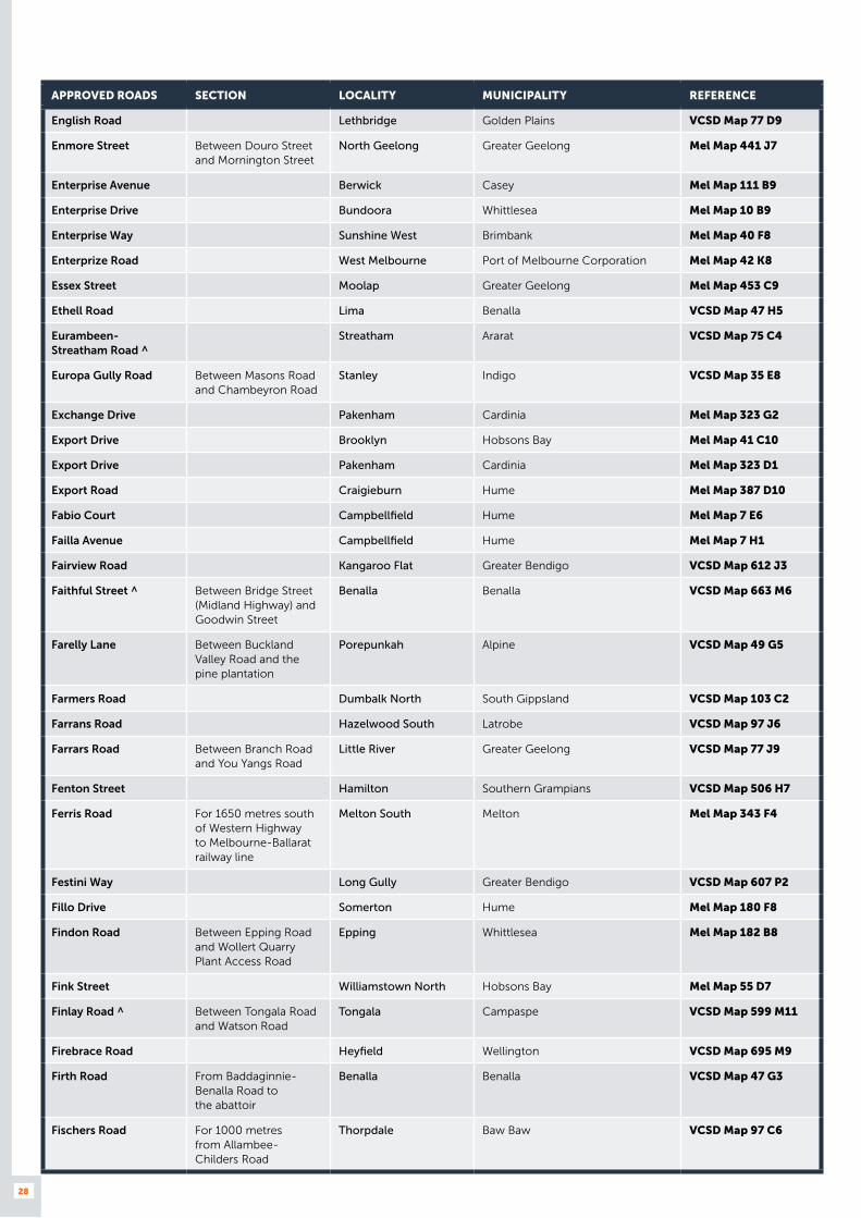
English Road Lethbridge Golden Plains VCSD Map 77 D9
Enmore Street Between Douro Street and Mornington Street
North Geelong Greater Geelong Mel Map 441 J7
Enterprise Avenue Berwick Casey Mel Map 111 B9
Enterprise Drive Bundoora Whittlesea Mel Map 10 B9
Enterprise Way Sunshine West Brimbank Mel Map 40 F8
Enterprize Road West Melbourne Port of Melbourne Corporation Mel Map 42 K8
Essex Street Moolap Greater Geelong Mel Map 453 C9
Ethell Road Lima Benalla VCSD Map 47 H5
Eurambeen- Streatham Road ^
Streatham Ararat VCSD Map 75 C4
Europa Gully Road Between Masons Road and Chambeyron Road
Stanley Indigo VCSD Map 35 E8
Exchange Drive Pakenham Cardinia Mel Map 323 G2
Export Drive Brooklyn Hobsons Bay Mel Map 41 C10
Export Drive Pakenham Cardinia Mel Map 323 D1
Export Road Craigieburn Hume Mel Map 387 D10
Fabio Court Campbellfield Hume Mel Map 7 E6
Failla Avenue Campbellfield Hume Mel Map 7 H1
Fairview Road Kangaroo Flat Greater Bendigo VCSD Map 612 J3
Faithful Street ^ Between Bridge Street (Midland Highway) and Goodwin Street
Benalla Benalla VCSD Map 663 M6
Farelly Lane Between Buckland Valley Road and the pine plantation
Porepunkah Alpine VCSD Map 49 G5
Farmers Road Dumbalk North South Gippsland VCSD Map 103 C2
Farrans Road Hazelwood South Latrobe VCSD Map 97 J6
Farrars Road Between Branch Road and You Yangs Road
Little River Greater Geelong VCSD Map 77 J9
Fenton Street Hamilton Southern Grampians VCSD Map 506 H7
Ferris Road For 1650 metres south of Western Highway to Melbourne-Ballarat railway line
Melton South Melton Mel Map 343 F4
Festini Way Long Gully Greater Bendigo VCSD Map 607 P2
Fillo Drive Somerton Hume Mel Map 180 F8
Findon Road Between Epping Road and Wollert Quarry Plant Access Road
Epping Whittlesea Mel Map 182 B8
Fink Street Williamstown North Hobsons Bay Mel Map 55 D7
Finlay Road ^ Between Tongala Road and Watson Road
Tongala Campaspe VCSD Map 599 M11
Firebrace Road Heyfield Wellington VCSD Map 695 M9
Firth Road From Baddaginnie- Benalla Road to the abattoir
Benalla Benalla VCSD Map 47 G3
Fischers Road For 1000 metres from Allambee- Childers Road
Thorpdale Baw Baw VCSD Map 97 C6

29
APPROVED ROADS SECTION LOCALITY MUNICIPALITY REFERENCE
Fish Creek- Walkerville Road
Between Kerrs Road and Waratah Road
Fish Creek South Gippsland VCSD Map 102 A6
Fish Creek- Waratah Road
For 2610 metres from Waratah Road
Waratah South Gippsland VCSD Map 103 B6
Fisher and Paykel Court
(private road for now) Derrimut Brimbank Mel Map 40 B6
Fitt Court East Bendigo Greater Bendigo VCSD Map 608 D4
Fitzgerald Place Portland Glenelg VCSD Map 501 N12
Fitzgerald Street Ferntree Gully Knox Mel Map 73 J3
Fitzgerald Street Between Scott Street and Garden Street
Portland Glenelg VCSD Map 501 N12
Fitzgibbons Road Between Walhalla-Tyers Road and Rintoul Creek
Tyers Latrobe VCSD Map 97 J4
Flat Lead Road For 100 metres from Whittlesea-Yea Road
Yea Murrindindi VCSD Map 61 H6
Flat Rock Road Between Beechworth-Wangaratta Road and Sheep Station Creek Road
Beechworth Indigo VCSD Map 35 C7
Flat Rock Road Between Malakoff Road and Prison
Beechworth Indigo VCSD Map 35 C7
Flattely Street Between Tuson Street and King Street
Ararat Ararat VCSD Map 554 G9
Fleet Street Somerton Hume Mel Map 180 G9
Florence Street Between Midland Highway and Old Dookie Road
Shepparton Greater Shepparton VCSD Map 673 T10
Flynn Court Derrimut Brimbank Mel Map 39 B5
Flynns Creek Road ^ Flynns Creek Latrobe VCSD Map 98 C5
Foch Street North Shore Greater Geelong Mel Map 442 D1
Foden Avenue Campbellfield Hume Mel Map 180 C11
Foley Road Yanakie South Gippsland VCSD Map 103 E6
Foleys Road East of Mount Derrimut Road only
Derrimut Brimbank Mel Map 25 E12
Footscray Road Service Road
West Melbourne Melbourne Mel Map 42 F6
Forbes Close Knoxfield Knox Mel Map 73 C7
Fordson Road Campbellfield Hume Mel Map 7 F6
Fordyce Street Between Midland Highway and Gilchrist Street
Shepparton Greater Shepparton VCSD Map 673 S10
Forest Road Between Grays Road and Gravel Pits Road
Paraparap Surf Coast VCSD Map 93 D7
Forest Road North Between Station Lake Road and property No. 45 Forest Road North (Unimin Lara Lime Plant)
Lara Greater Geelong Mel Map 422 K5
Forest Street Between Aireys Street and Parkinson Street
Colac Colac Otway VCSD Map 520 H6
Forge Creek Road ^ Between Princes Highway and Johnstons Road
Bairnsdale East Gippsland VCSD Map 688 F11

30
APPROVED ROADS SECTION LOCALITY MUNICIPALITY REFERENCE
Forsyth Road Between Old Geelong Road and property No. 6 Forsyth Road
Hoppers Crossing Wyndham Mel Map 203 F10
Foster Street Between Gibbo Street and King Street
Benambra East Gippsland VCSD Map 51 D9
Foundry Road Between Anderson Road and Harvester Road
Sunshine Brimbank Mel Map 26 H10
Fourth Avenue Sunshine Brimbank Mel Map 40 J4
Fox Street Between Winton-Glenrowan Road and the entrance of Winton Motor Raceway
Benalla Benalla VCSD Map 48 B2
Foxley Court Derrimut Brimbank Mel Map 39 C6
Framlingham Road Framlingham Moyne VCSD Map 90 C6
Francis Briggs Road Melbourne Airport Melbourne Airport Mel Map 5 C6
Francis Road For 3300 metres from Moe-Glengarry Road (Glengarry-Tyers Road)
Glengarry West Latrobe VCSD Map 98 A3
Francis Street For 160 metres south east of Francis Street/Whitehall Street intersection
Yarraville Port of Melbourne Corporation Mel Map 42 D10
Frank Hayes Drive Wangaratta Wangaratta VCSD Map 664 C10
Franklin Street Between Kay Street and Grey Street (Tyers Road)
Traralgon Latrobe VCSD Map 696 H6
Frankston Gardens Drive
Carrum Downs Frankston Mel Map 100 B2
Frasers Lane Between Traralgon-Maffra Road and Wellington Road
Glengarry North Latrobe VCSD Map 98 B3
Frasers Road Hazelwood Latrobe VCSD Map 97 H6
Frederick Road Tottenham Maribyrnong Mel Map 41 B5
Freedman Street North Geelong Greater Geelong Mel Map 441 J3
Freeman Street Campbellfield Hume Mel Map 7 G1
Freight Drive Somerton Hume Mel Map 180 H10
French Street Between Cox Street and Thompson Street
Hamilton Southern Grampians VCSD Map 506 E9
Frog Court Craigieburn Hume Mel Map 180 E2
Fryers Street Between Thompson Street and Archer Street
Shepparton Shepparton VCSD Map 673 Q9
Frys Track Between Marretts Road and McDonalds Track
Hernes Oak Latrobe VCSD Map 97 G5
Fulham Road Between Darebin Road and Chingford Street
Alphington Darebin Mel Map 31 B8
Fullers Road Between Lower Franklin Road and Old Hat Road
Foster South Gippsland VCSD Map 103 D4
Fulton Drive Derrimut Brimbank Mel Map 39 F7
Furner Avenue From Thompson Road for 100 metres to property No. 116
Bell Park Greater Geelong Mel Map 441 H3
Fussell Road Montrose Yarra Ranges Mel Map 51 J9

31
APPROVED ROADS SECTION LOCALITY MUNICIPALITY REFERENCE
Fussell Street Between Ballarat-Burrumbeet Road (Victoria Street) and Charlesworth Street
Ballarat East Ballarat VCSD Map 566 K8
Gadsden Court Wodonga Wodonga VCSD Map 652 J2
Gaine Road Dandenong South Greater Dandenong Mel Map 95 K7
Gallivan Road New Gisborne Macedon Ranges VCSD Map 636 F2
Ganton Court Williamstown North Hobsons Bay Mel Map 55 C7
Gap Flat Road Allans Flat Indigo VCSD Map 35 G6
Gap Road Between Back Beach Road and Grand Prix track entrance
Phillip Island Bass Coast VCSD Map 468 F10
Garden Boulevard Between Boundary Road and Redwood Drive
Dingley Village Kingston Mel Map 88 A4
Garden Gully Road ^ Between Western Highway and Cemetery Road
Great Western Northern Grampians VCSD Map 56 F4
Garden Street Morwell Latrobe VCSD Map 699 T5
Garden Street Between Fitzgerald Street and Henty Highway
Portland Glenelg VCSD Map 501 N12
Garvey Road Kerang Gannawarra VCSD Map 592 E6
Gasoline Way Craigieburn Hume Mel Map 180 D2
Gatehouse Road Between Horsham-Kalkee Road and Geodetic Road
Horsham Horsham VCSD Map 40 E4
Gateway Boulevard Epping Whittlesea Mel Map 181 F9
Gatwick Road Bayswater North Maroondah Mel Map 51 C10
Geary Road Leongatha South Gippsland VCSD Map 710 E7
Geelong Road Ararat Ararat VCSD Map 56 H6
Geelong Road Service Road
Brooklyn Brimbank Mel Map 40 J10
Gemini Crescent Shepparton Greater Shepparton VCSD Map 673 T5
Geodetic Road Between Aerodrome Road and the grain storage facility
Horsham Horsham VCSD Map 40 D4
Gerang-Glenlee Road ^ Glenlee Hindmarsh VCSD Map 25 F6
Gertrude Street Between Lynott Street and Mill Street
Horsham Horsham VCSD Map 544 G4
Gibbs Place Between Nelson Street and McPhersons Carpark
Maryborough Central Goldfields VCSD Map 558 E10
Gibson Street Wangaratta Wangaratta VCSD Map 664 C9
Gifford Avenue Ferntree Gully Knox Mel Map 73 K4
Gilbert Park Drive Between Rushdale Street and Forbes Close
Knoxfield Knox Mel Map 73 C6
Gilbertson Road Laverton North Wyndham Mel Map 39 H10
Gilchrist Road Between Western Highway and Hutton Court
Stawell Northern Grampians VCSD Map 550 D12

32
APPROVED ROADS SECTION LOCALITY MUNICIPALITY REFERENCE
Giles Road For 670 metres from Mirboo North-Trafalgar Road
Trafalgar Baw Baw VCSD Map 703 R12
Giles Street Bairnsdale East Gippsland VCSD Map 688 G10
Gillies Street Between Roe Street and Racecourse Road
Benalla Benalla VCSD Map 663 Q4
Gillies Street Between Railway Street and Golden Wattle Drive
Maryborough Central Goldfields VCSD Map 558 E9
Giot Drive Wendouree Ballarat VCSD Map 562 A10
Gladstone Street Glenrowan Wangaratta VCSD Map 666 F11
Glen Avenue Belmont Greater Geelong Mel Map 451 K12
Glenbarry Road Campbellfield Hume Mel Map 7 F3
Glenelg Street Between Maffra Street and Kyabram Street
Coolaroo Hume Mel Map 180 A12
Glengarry North Road Between Traralgon-Maffra Road and Cemetery Road
Glengarry North Latrobe VCSD Map 98 B3
Glenlee-Lorquon Road Lorquon Hindmarsh VCSD Map 25 E4
Glenmore Street North Shore Greater Geelong Mel Map 442 D1
Glenorchy Road ^ For 1100 metres north east of Marl and Burbury Street intersection
Glenorchy Northern Grampians VCSD Map 551 U3
Glenrowan- Moyhu Road
Between Gladstone Street and quarry entrance
Glenrowan Wangaratta VCSD Map 34 E9
Glenthompson-Caramut Road ^
Glenthompson Southern Grampians VCSD Map 74 A4
Golden Crescent Wendouree Ballarat VCSD Map 562 B11
Golf Course Road Between Henty Highway and Kenny Road
Horsham Horsham VCSD Map 544 D11
Goodings Road Yinnar Latrobe VCSD Map 97 H7
Goodwin Street Benalla Benalla VCSD Map 663 M6
Goonans Road Between Boggy Creek Road and Timboon-Nullaware Road
Nullaware Moyne VCSD Map 90 E9
Gooramadda Road Between Up River Road and Chilton- Howlong Road
Gooramadda Indigo VCSD Map 34 B2
Gordon Street Between High Street and Elizabeth Street
Ararat Ararat VCSD Map 54 H9
Gordon Luck Avenue Altona North Hobsons Bay Mel Map 54 C2
Gosney Street Between Murrell Street and Mousley Road
Winchelsea Surf Coast VCSD Map 525 M3
Goulburn Street ^ Nagambie Strathbogie VCSD Map 678 J4
Grace Court Sunshine West Brimbank Mel Map 40 H5
Graham Street Between Boundary Road North and the southern boundary of the saleyards
Euroa Strathbogie VCSD Map 677 M7

33
APPROVED ROADS SECTION LOCALITY MUNICIPALITY REFERENCE
Graham Street Between Williamstown Road and CityLink
Port Melbourne Port Phillip Mel Map 57 A1
Grandlee Drive Wendouree Ballarat VCSD Map 565 Q2
Grandview Parade Moolap Greater Geelong Mel Map 453 E9
Grano Street Between Alfred Street and Nott Road
Ararat Ararat VCSD Map 554 K6
Grant Street Between Dalmahoy Street and Saleyard Road
Bairnsdale East Gippsland VCSD Map 688 H9
Grant Street Between Princes Highway and MacLeod Street
Bairnsdale East Gippsland VCSD Map 688 H8
Grant Street Between Hertford Street and property No. 2A Grant Street
Sebastopol Ballarat VCSD Map 571 T2
Granter Street For 50 metres from Watson Street
Warrnambool Warrnambool VCSD Map 514 E6
Grasslands Avenue Craigieburn Hume Mel Map 180 C2
Gravel Pits Road Geelong South Greater Geelong Mel Map 452 C11
Gray Street Between Tyers Street and Mill Road
Hamilton Southern Grampians VCSD Map 506 J6
Gray Street Between Dundas Street and Kings Avenue (Sunraysia Highway)
St Arnaud Northern Grampians VCSD Map 551 T10
Gray Street For 600 metres south-east from Sea Lake-Swan Hill Road
Swan Hill Swan Hill VCSD Map 586 C5
Grays Road Between Hendy Main Road and Forest Road
Paraparap Surf Coast VCSD Map 93 D6
Green Street Between Maroondah Highway and William Street
Alexandra Murrindindi VCSD Map 680 D3
Green Street Between Power Road and Claredale Street
Doveton Casey Mel Map 90 H11
Greenham Street Between Princes Highway and Ascot Street
Dartmoor Glenelg VCSD Map 501 L4
Greenhills Road Between Healesville-Koo Wee Rup Road and Corporate Terrace
Pakenham Cardiniaa Mel Map 323 E3
Greens Creek Road Greens Creek Northern Grampians VCSD Map 41 F9
Greens Road Cohuna Gannawarra VCSD Map 21 E7
Gregory Street West Between Gillies Street and railway line
Lake Gardens Ballarat VCSD Map 565 R3
Gregory Street West Between Ring Road and railway line
Wendouree Ballarat VCSD Map 565 O3
Greygown Street West Wodonga Wodonga VCSD Map 652 H4
Grieve Street Between Smith Street and Wilson Street
Stawell Northern Grampians VCSD Map 550 C8
Griffith Street Knoxfield Knox Mel Map 73 C6
Griffiths Street ^ Between Western Highway and Lake Road
Stawell Northern Grampians VCSD Map 550 B9
Grimes Court Derrimut Brimbank Mel Map 39 A6

34
APPROVED ROADS SECTION LOCALITY MUNICIPALITY REFERENCE
Grip Road ^ For 1500 metres from South Gippsland Highway
Toora South Gippsland VCSD Map 103 F4
Grove Road Between Surf Coast Highway and Dendle Street
Grovedale Greater Geelong Mel Map 465 J4
Gundowring Road Between Lockharts Gap Road and Boyd Road
Gundowring Indigo VCSD Map 36 B8
Hall Road Carrum Downs Frankston Mel Map 100 F2
Hall Street Braeside Kingston Mel Map 87 K8
Hallam Valley Road Dandenong South Great Dandenong Mel Map 95 J3
Halley Crescent Campbellfield Hume Mel Map 180 D11
Hamilton- Chatsworth Road
Hamilton Southern Grampians VCSD Map 73 E6
Hammel Court Hallam Casey Mel Map 96 F1
Hammer Court Wendouree Ballarat VCSD Map 566 B1
Hammond Place Warrnambool Warrnambool VCSD Map 514 E4
Hammond Road Ballyrogan Ararat VCSD Map 57 C9
Hammond Road Between Cheltenham Road and Webster Street
Dandenong South Greater Dandenong Mel Map 90 C9
Hammond Road Between Rhur Street and Bangholme Road
Dandenong South Greater Dandenong Mel Map 95 A8
Hammond Street Hamilton Southern Grampians VCSD Map 506 C5
Hansen Road Casterton Glenelg VCSD Map 500 B3
Happy Valley Road ^ Between Robinvale-Sea Lake Road and Hocking Road
Robinvale Swan Hill VCSD Map 7 D4
Harbeck Street Between Traralgon-Maffra Road and Temple Street
Heyfield Wellington VCSD Map 695 P11
Harcourt Road Altona Hobsons Bay Mel Map 53 G6
Hard Hills Road For 1500 metres east from Yawong Road (sealed section)
Slaty Creek Northern Grampians VCSD Map 42 F3
Hardie Road Brooklyn Hobsons Bay Mel Map 41 D9
Hardy Street Between Broadway (Maryborough- Dunolly Road) and Desmond Street
Dunolly Central Goldfields VCSD Map 559 S4
Hargreaves Road Maude Golden Plains VCSD Map 77 9E
Harpin Street For 300 metres south of Strickland Road
East Bendigo Greater Bendigo VCSD Map 608 C3
Harrick Road Keilor Park Brimbank Mel Map 15 A7
Harris Lane Stawell Northern Grampians VCSD Map 56 E2
Hartnett Drive Seaford Frankston Mel Map 99 H7
Harvester Road Between Ballarat Road (Western Highway) and the service station immediately south of Foundry Road
Sunshine Brimbank Mel Map 26 G11
Haughton Street Stawell Northern Grampians VCSD Map 550 C6

35
APPROVED ROADS SECTION LOCALITY MUNICIPALITY REFERENCE
Havelock Road Bayswater Knox Mel Map 64 A4
Havilah Road Between Happy Valley Road and the pine plantation
Rosewhite Alpine VCSD Map 49 F3
Hawkins Street Shepparton Greater Shepparton VCSD Map 673 P3
Hay Avenue Wangaratta Wangaratta VCSD Map 664 E11
Hayes Road Newborough Latrobe VCSD Map 701 L3
Hays Road Moolap Greater Geelong Mel Map 453 H6
Haysdale- Kooloonong Road ^
Robinvale Swan Hill VCSD Map 8 D8
Hazelwood Drive Morwell Latrobe VCSD Map 699 O8
Hazelwood Estate Road
Between Yinnar Road and Monash Way
Hazelwood Latrobe VCSD Map 97 G7
Head Street Traralgon Latrobe VCSD Map 697 L5
Heales Road Between Forest Road South and Geelong-Bacchus Marsh Road
Corio Greater Geelong Mel Map 432 G1
Healey Road Dandenong South Greater Dandenong Mel Map 95 G6
Heaths Court Mill Park Whittlesea Mel Map 10 E1
Heinz Lane Between Midland Highway and Old Creswick Road
Wendouree Ballarat VCSD Map 562 C12
Heinz Road Delacombe Ballarat VCSD Map 565 Q10
Helendoite Road ^ Between Mortlake-Ararat Road and Tatyoon North Road
Maroona Ararat VCSD Map 56 G9
Henderson Road Between Ferntree Gully Road and Henderson Road
Knoxfield Knox Mel Map 73 B8
Henderson Road Between Laser Drive and Valleyview Drive
Rowville Knox Mel Map 72 K10
Hendersons Road Between Stringer Road and Guyatts Road
Toongabbie Latrobe VCSD Map 703 N4
Henry Street Northern section only, between Lambing Gully Road and Livingstone Street
Avenel Strathbogie VCSD Map 677 R6
Hensley Park Road Hamilton Southern Grampians VCSD Map 73 B4
Hewitt Street Cheltenham Kingston Mel Map 77 K9
High Street Between Hossack Road and Palmerston Street
Baddaginnie Benalla VCSD Map 47 F3
High Street Between Havelock Street and Stanhope Street
Barnawartha Indigo VCSD Map 658 G10
High Street Between Elgin Road and Ford Street (Beechworth-Wangaratta Road)
Beechworth Indigo VCSD Map 659 O5
High Street Between Framlingham Road and Ellerslie-Panmure Road
Framlingham Moyne VCSD 90 D5
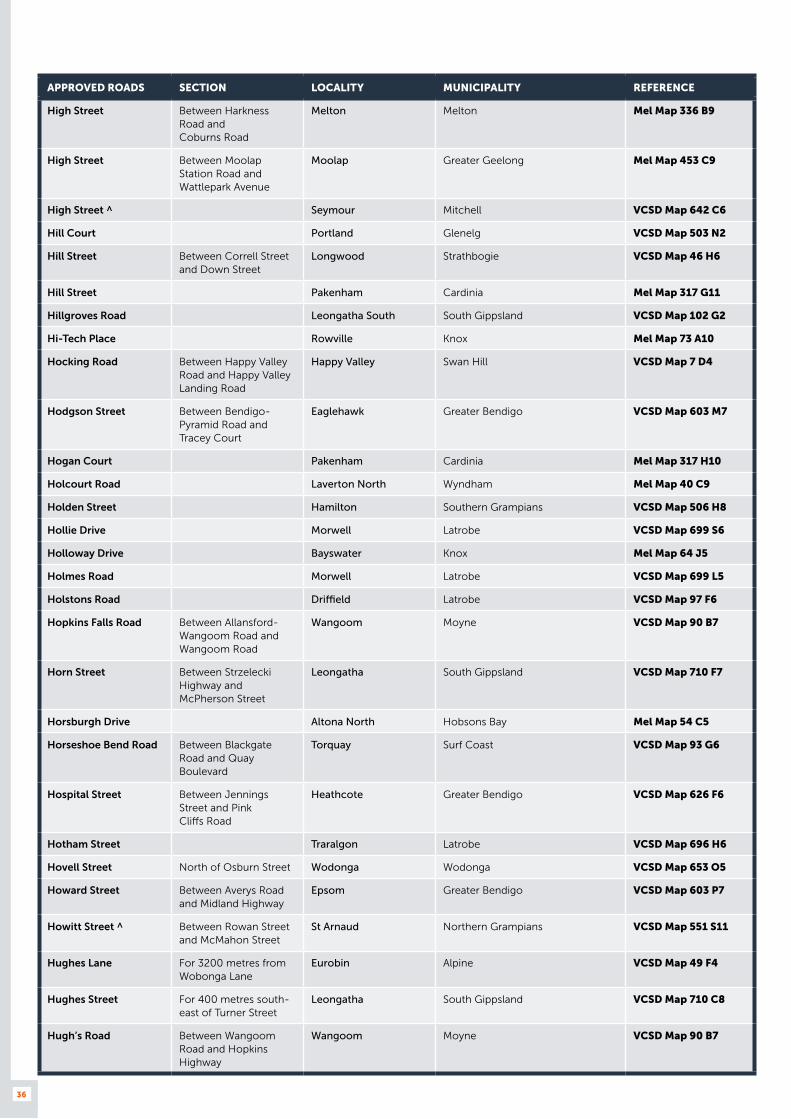
36
APPROVED ROADS SECTION LOCALITY MUNICIPALITY REFERENCE
High Street Between Harkness Road and Coburns Road
Melton Melton Mel Map 336 B9
High Street Between Moolap Station Road and Wattlepark Avenue
Moolap Greater Geelong Mel Map 453 C9
High Street ^ Seymour Mitchell VCSD Map 642 C6
Hill Court Portland Glenelg VCSD Map 503 N2
Hill Street Between Correll Street and Down Street
Longwood Strathbogie VCSD Map 46 H6
Hill Street Pakenham Cardinia Mel Map 317 G11
Hillgroves Road Leongatha South South Gippsland VCSD Map 102 G2
Hi-Tech Place Rowville Knox Mel Map 73 A10
Hocking Road Between Happy Valley Road and Happy Valley Landing Road
Happy Valley Swan Hill VCSD Map 7 D4
Hodgson Street Between Bendigo-Pyramid Road and Tracey Court
Eaglehawk Greater Bendigo VCSD Map 603 M7
Hogan Court Pakenham Cardinia Mel Map 317 H10
Holcourt Road Laverton North Wyndham Mel Map 40 C9
Holden Street Hamilton Southern Grampians VCSD Map 506 H8
Hollie Drive Morwell Latrobe VCSD Map 699 S6
Holloway Drive Bayswater Knox Mel Map 64 J5
Holmes Road Morwell Latrobe VCSD Map 699 L5
Holstons Road Driffield Latrobe VCSD Map 97 F6
Hopkins Falls Road Between Allansford-Wangoom Road and Wangoom Road
Wangoom Moyne VCSD Map 90 B7
Horn Street Between Strzelecki Highway and McPherson Street
Leongatha South Gippsland VCSD Map 710 F7
Horsburgh Drive Altona North Hobsons Bay Mel Map 54 C5
Horseshoe Bend Road Between Blackgate Road and Quay Boulevard
Torquay Surf Coast VCSD Map 93 G6
Hospital Street Between Jennings Street and Pink Cliffs Road
Heathcote Greater Bendigo VCSD Map 626 F6
Hotham Street Traralgon Latrobe VCSD Map 696 H6
Hovell Street North of Osburn Street Wodonga Wodonga VCSD Map 653 O5
Howard Street Between Averys Road and Midland Highway
Epsom Greater Bendigo VCSD Map 603 P7
Howitt Street ^ Between Rowan Street and McMahon Street
St Arnaud Northern Grampians VCSD Map 551 S11
Hughes Lane For 3200 metres from Wobonga Lane
Eurobin Alpine VCSD Map 49 F4
Hughes Street For 400 metres south-east of Turner Street
Leongatha South Gippsland VCSD Map 710 C8
Hugh’s Road Between Wangoom Road and Hopkins Highway
Wangoom Moyne VCSD Map 90 B7

37
APPROVED ROADS SECTION LOCALITY MUNICIPALITY REFERENCE
Hulls Road Nerrena South Gippsland VCSD Map 97 B9
Hume Highway Service Road
East of Hume Highway between Encore Avenue and Cooper Street
Somerton Hume Mel Map 180 E7
Hume Road Laverton North Wyndham Mel Map 39 K12
Hume Street Between Murray Valley Highway (Ogilvie Avenue) and Service Street
Echuca Campaspe VCSD Map 596 J7
Hunt Place ^ Wurruk Wellington VCSD Map 692 H5
Hunter Road Derrimut Brimbank Mel Map 39 F1
Hunter Road Yallourn North Latrobe VCSD Map 97 G3
Hunter Road ^ Between Healesville-Kinglake Road and Railway Parade
Healesville Yarra Ranges Mel Map 277 K1
Hunter Street Tatura Greater Shepparton VCSD Map 671 M4
Huntly-Fosterville Road
Between Axedale-Goornong Road and McCormicks Road
Fosterville Greater Bendigo VCSD Map 44 J5
Huon-Kiewa Road Tangambalanga Indigo VCSD Map 36 B5
Hutchinson Street Lilydale Yarra Ranges Mel Map 38 D5
Hutton Court Stawell Northern Grampians VCSD Map 550 D12
Hydrive Close Dandenong South Greater Dandenong Mel Map 95 H7
Icon Drive Delacombe Ballarat VCSD Map 565 O10
Indigo Creek Road Between Hume Freeway and Plemings Road
Barnawartha Indigo VCSD Map 658 J11
Industrial Avenue Thomastown Whittlesea Mel Map 8 A10
Industrial Drive Between Boundary Road and Governor Road
Braeside Kingston Mel Map 87 K12
Industry Park Drive Brooklyn Brimbank Mel Map 41 B8
Ingles Street Between Lorimer Street and West Gate Freeway
Port Melbourne Melbourne Mel Map 43 A10
Ingles Street Between West Gate Freeway and Williamstown Road
Port Melbourne Port Phillip Mel Map 43 A10
Inglewood Drive Thomastown Whittlesea Mel Map 9 C10
Inkerman Street Between Hardy Street and Tweeddale Street
Dunolly Central Goldfields VCSD Map 559 S3
Inkerman Street Between the railway line and Gladstone Street
Maryborough Central Goldfields VCSD Map 558 C6
Inkerman Street Between Dundas Street and Sunraysia Highway (Napier Street)
St Arnaud Northern Grampians VCSD Map 551 S9
Innovation Drive Delacombe Ballarat VCSD Map 565 N10
Interchange Drive Laverton North Wyndham Mel Map 53 D3
Intrepid Street Berwick Casey Mel Map 111 B9
Inverlochy Street Anglesea Surf Coast VCSD Map 526 G3

38
APPROVED ROADS SECTION LOCALITY MUNICIPALITY REFERENCE
Inverness Road Between Marungi Road and Creighton Road
Katandra West Greater Shepparton VCSD Map 33 B4
Isa Way Boronia Knox Mel Map 65 C2
Ives Road Altona North Hobsons Bay Mel Map 54 F3
Jackson Street Between Sturton Street and Eaglehawk Road
California Gully Greater Bendigo VCSD Map 607 O2
Janette Street Traralgon Latrobe VCSD Map 696 H8
Janine Street Between Ferntree Gully Road and Keith Campbell Court
Scoresby Knox Mel Map 72 H8
Jarrah Drive Between Baxter Drive and Malcolm Road
Braeside Kingston Mel Map 88 A12
Jarrahmond Road Between Forest Road and Yalmy Road
Orbost East Gippsland VCSD Map 684 A6
Jaydee Court Rowville Knox Mel Map 81 E3
Jeeralang North Road Between Hazelwood Road (Churchill-Traralgon Road) and the south leg of Munckton Road
Hazelwood North Latrobe VCSD Map 97 J6
Jellico Drive Scoresby Knox Mel Map 72 E7
Jenkinsons Road Wodonga Wodonga VCSD Map 653 P4
Jennings Road Thorpdale Baw Baw VCSD Map 97 D6
Jennings Street Between High Street and Hospital Street
Heathcote Greater Bendigo VCSD Map 626 F7
Jeparit East Road Jeparit Hindmarsh VCSD Map 26 B4
Jersey Road Bayswater Knox Mel Map 64 J5
Jesica Road Campbellfield Hume Mel Map 7 F1
Jets Court Melbourne Airport Melbourne Airport Mel Map 15 B2
Jilly Court Derrimut Brimbank Mel Map 39 E5
John Deere Court (private road for now) Derrimut Brimbank Mel Map 40 B7
Johnson Street Between Loch Street and Nelson Street
Maryborough Central Goldfields VCSD Map 558 E10
Johnstons Road Bairnsdale East Gippsland VCSD Map 84 B8
Jones Road Brooklyn Brimbank Mel Map 40 H9
Jones Road Morwell Latrobe VCSD Map 699 U6
Jordon Close Altona Hobsons Bay Mel Map 54 C8
Jubilee Road For 100 metres south of Albion Road
Stawell Northern Grampians VCSD Map 550 J9
Jubilee Street Myrtleford Alpine VCSD Map 660 B4
Judge Street For 240 metres east then north of Market Road to No. 49 Judge Street
Sunshine Brimbank Mel Map 40 K5
Jumbuk Road Between Main Street (Yinnar Road) and Middle Creek Road
Yinnar Latrobe VCSD Map 701 S3
Junction Road Beechworth Indigo VCSD Map 659 P3
June Court Warragul Baw Baw VCSD Map 704 J7
Kalingra Road Tottenham Maribyrnong Mel Map 41 B6

39
APPROVED ROADS SECTION LOCALITY MUNICIPALITY REFERENCE
Kalman Drive Boronia Knox Mel Map 65 C3
Kancoona South Road Between Running Creek Road and Morgans Creek Road
Kancoona Alpine VCSD Map 49 H3
Kane Road Wodonga Wodonga VCSD Map 653 P5
Karinie Street Swan Hill Swan Hill VCSD Map 586 E1
Karook Street Between Racecourse Road and Dillon Street
Cobram Moira VCSD Map 667 M7
Katandra Main Road Between Katamatite-Shepparton Road and Cosgrove Road
Katandra West Greater Shepparton VCSD Map 33 B5
Kay Street Traralgon Latrobe VCSD Map 696 C6
Kearney Street Bayswater Knox Mel Map 64 H4
Kearsley Court Altona North Hobsons Bay Mel Map 54 F3
Keith Campbell Court Scoresby Knox Mel Map 72 H8
Kell Road Between Burnside Road and Daly Road
St Arnaud Northern Grampians VCSD Map 551 T12
Kelletts Road Service Road
Between Henderson Road and Laser Drive
Rowville Knox Mel Map 73 A11
Kelly Street ^ Wodonga Wodonga VCSD Map 653 L4
Kendall Street Between Chapple Street and Kane Road
Wodonga Wodonga VCSD Map 653 P5
Kennedy Street East Bendigo Greater Bendigo VCSD Map 607 U5
Kennedys Drive Delacombe Ballarat VCSD Map 565 P10
Kenny Road Between Henty Highway and Turnbull Drive
Horsham Horsham VCSD Map 544 F11
Keppel Drive Between Hallam Road (Hallam South Road) and Colrado Court
Hallam Casey Mel Map 96 H3
Kergunyah Road Kergunyah Indigo VCSD Map 36 B7
Kerr Street Wangaratta Wangaratta VCSD Map 664 C10
Kerrs Road Fish Creek South Gippsland VCSD Map 103 A6
Kettlewells Road Monegeetta Macedon Ranges VCSD Map 60 E8
Kevin Avenue Ferntree Gully Knox Mel Map 73 J4
Key West Place Derrimut Brimbank Mel Map 39 C4
Kiata South Road Kiata Hindmarsh VCSD Map 25 E8
Kidston Parade Between Maroondah Highway and Malcolm Street
Mansfield Mansfield VCSD Map 679 M5
Kiewa-Bonegilla Road Between Kiewa East Road and Coulston Road
Tangambalanga Indigo VCSD Map 36 B5
Kilfeera Road Between Benalla-Tatong Road and Upper Lurg Road
Kilfeera Benalla VCSD Map 48 C3
Killara Road Campbellfield Hume Mel Map 7 H4
Kinder Street Campbellfield Hume Mel Map 7 H3
King Drive Horsham Horsham VCSD Map 544 E10
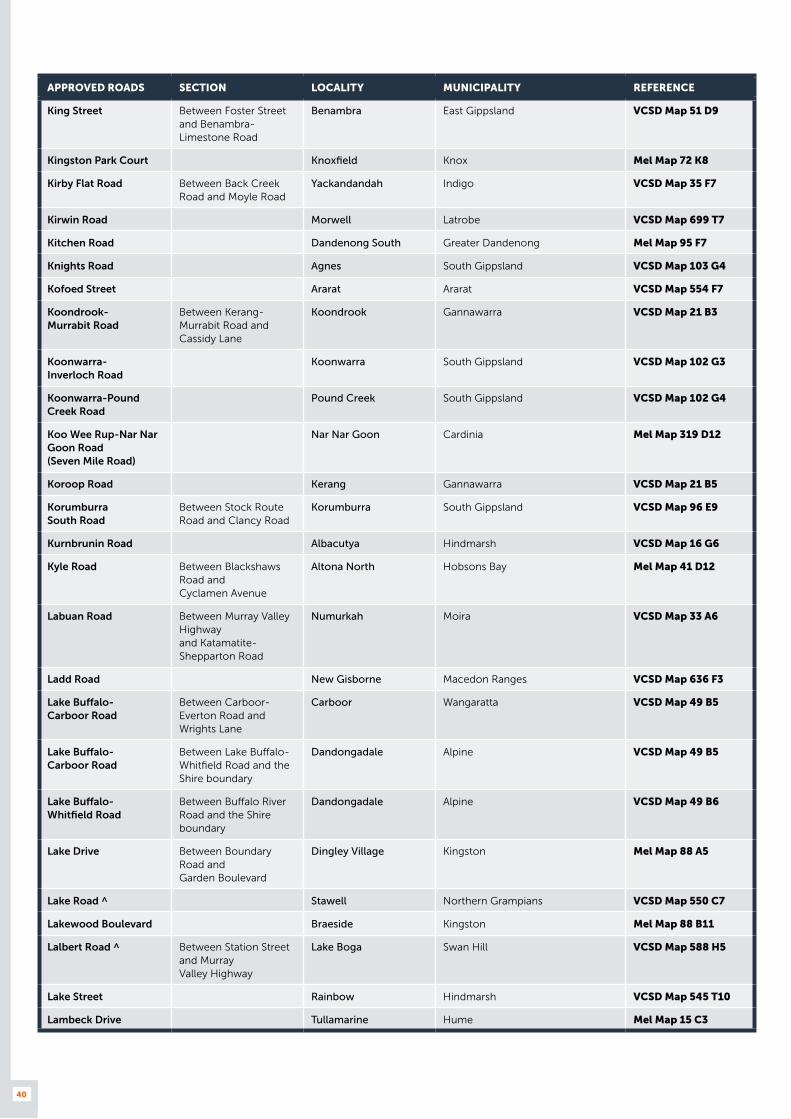
40
APPROVED ROADS SECTION LOCALITY MUNICIPALITY REFERENCE
King Street Between Foster Street and Benambra-Limestone Road
Benambra East Gippsland VCSD Map 51 D9
Kingston Park Court Knoxfield Knox Mel Map 72 K8
Kirby Flat Road Between Back Creek Road and Moyle Road
Yackandandah Indigo VCSD Map 35 F7
Kirwin Road Morwell Latrobe VCSD Map 699 T7
Kitchen Road Dandenong South Greater Dandenong Mel Map 95 F7
Knights Road Agnes South Gippsland VCSD Map 103 G4
Kofoed Street Ararat Ararat VCSD Map 554 F7
Koondrook- Murrabit Road
Between Kerang-Murrabit Road and Cassidy Lane
Koondrook Gannawarra VCSD Map 21 B3
Koonwarra- Inverloch Road
Koonwarra South Gippsland VCSD Map 102 G3
Koonwarra-Pound Creek Road
Pound Creek South Gippsland VCSD Map 102 G4
Koo Wee Rup-Nar Nar Goon Road (Seven Mile Road)
Nar Nar Goon Cardinia Mel Map 319 D12
Koroop Road Kerang Gannawarra VCSD Map 21 B5
Korumburra South Road
Between Stock Route Road and Clancy Road
Korumburra South Gippsland VCSD Map 96 E9
Kurnbrunin Road Albacutya Hindmarsh VCSD Map 16 G6
Kyle Road Between Blackshaws Road and Cyclamen Avenue
Altona North Hobsons Bay Mel Map 41 D12
Labuan Road Between Murray Valley Highway and Katamatite-Shepparton Road
Numurkah Moira VCSD Map 33 A6
Ladd Road New Gisborne Macedon Ranges VCSD Map 636 F3
Lake Buffalo- Carboor Road
Between Carboor-Everton Road and Wrights Lane
Carboor Wangaratta VCSD Map 49 B5
Lake Buffalo- Carboor Road
Between Lake Buffalo-Whitfield Road and the Shire boundary
Dandongadale Alpine VCSD Map 49 B5
Lake Buffalo- Whitfield Road
Between Buffalo River Road and the Shire boundary
Dandongadale Alpine VCSD Map 49 B6
Lake Drive Between Boundary Road and Garden Boulevard
Dingley Village Kingston Mel Map 88 A5
Lake Road ^ Stawell Northern Grampians VCSD Map 550 C7
Lakewood Boulevard Braeside Kingston Mel Map 88 B11
Lalbert Road ^ Between Station Street and Murray Valley Highway
Lake Boga Swan Hill VCSD Map 588 H5
Lake Street Rainbow Hindmarsh VCSD Map 545 T10
Lambeck Drive Tullamarine Hume Mel Map 15 C3

41
APPROVED ROADS SECTION LOCALITY MUNICIPALITY REFERENCE
Lambing Gully Road Between Hume Freeway and Seymour-Avenel Road
Avenel Strathbogie VCSD Map 677 R6
Landrigan Road ^ Between Ballarat-Maryborough Road and Majorca Road
Craigie Central Goldfields VCSD Map 58 D3
Landsborough Road Between Leviathan Road and Pyrenees Shire Boundary
Stawell Northern Grampians VCSD Map 56 J2
Langdon Street North Geelong Greater Geelong Mel Map 442 B5
Lansell Street Between Charleston Road and Melbourne-Murray River Railway Reserve
Bendigo Greater Bendigo VCSD Map 607 U5
Lanyon Street Dandenong South Greater Dandenong Mel Map 95 F4
Lara Way Campbellfield Hume Mel Map 7 H1
Lardner Road Drouin Baw Baw VCSD Map 706 F8
Larneuk Street North Shore Greater Geelong Mel Map 442 D1
Laser Drive Between Kelletts Road and Henderson Road
Rowville Knox Mel Map 73 A10
Lathams Road Carrum Downs Frankston Mel Map 100 A1
Lawless Street Between Princes Highway and 50 metres west of O’Denver Street
Bairnsdale East Gippsland VCSD Map 688 C10
Lawn Court Craigieburn Hume Mel Map 387 D10
Leach Road Agnes South Gippsland VCSD Map 103 G4
Leader Street Campbellfield Hume Mel Map 180 C9
Leakes Road For 1050 metres north of Melton Highway to quarry
Plumpton Melton Mel Map 338 K7
Leakes Road Between Palmers Road and Fitzgerald Road
Truganina Wyndham Mel Map 203 J3
Lean Street Between Derby Road (Ballarat-Maryborough Road) and the railway line
Maryborough Central Goldfields VCSD Map 558 C10
Leans Road Between Midland Highway and Wallanjoe Road
Huntly Greater Bendigo VCSD Map 600 B10
Learmonth Road Carrum Downs Frankston Mel Map 98 A7
Learmonth Street Between Winter Street and Napier Street
Alfredton Ballarat VCSD Map 565 P9
Learmonth Street West from Browning Street to the end of the street
Portland Glenelg VCSD Map 501 N11
Learmonth-Sulky Road Between Ballarat-Maryborough Road and Sunraysia Highway
Blowhard Ballarat VCSD Map 58 E9
Leather Street Between Tucker Street and Boundary Road
Breakwater Greater Geelong Mel Map 466 D2
Leek Street Yarraville Maribyrnong Mel Map 42 C9
Leakes Road For 1050 metres north of Melton Highway to quarry
Plumpton Melton Mel Map 338 K7
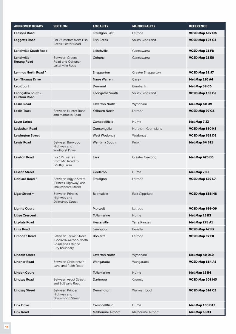
42
APPROVED ROADS SECTION LOCALITY MUNICIPALITY REFERENCE
Leesons Road Traralgon East Latrobe VCSD Map 697 O4
Leggetts Road For 75 metres from Fish Creek-Foster Road
Fish Creek South Gippsland VCSD Map 103 C4
Leitchville South Road Leitchville Gannawarra VCSD Map 21 F8
Leitchville- Kerang Road
Between Greens Road and Cohuna-Leitchville Road
Cohuna Gannawarra VCSD Map 21 E8
Lemnos North Road ^ Shepparton Greater Shepparton VCSD Map 32 J7
Len Thomas Drive Narre Warren Casey Mel Map 110 A4
Leo Court Derrimut Brimbank Mel Map 39 C6
Leongatha South-Outtrim Road
Leongatha South South Gippsland VCSD Map 102 G2
Leslie Road Laverton North Wyndham Mel Map 40 D9
Leslie Track Between Hunter Road and Manuells Road
Yallourn North Latrobe VCSD Map 97 G3
Lever Street Campbellfield Hume Mel Map 7 J3
Leviathan Road Concongella Northern Grampians VCSD Map 550 K8
Lewington Street West Wodonga Wodonga VCSD Map 652 D3
Lewis Road Between Burwood Highway and Wadhurst Drive
Wantirna South Knox Mel Map 64 B11
Lewton Road For 175 metres from Mill Road to Poultry Farm
Lara Greater Geelong Mel Map 423 D3
Lexton Street Coolaroo Hume Mel Map 7 B2
Liddiard Road ^ Between Argyle Street (Princes Highway) and Shakespeare Street
Traralgon Latrobe VCSD Map 697 L7
Ligar Street ^ Between Princes Highway and Dalmahoy Street
Bairnsdale East Gippsland VCSD Map 688 H8
Lignite Court Morwell Latrobe VCSD Map 699 O9
Lillee Crescent Tullamarine Hume Mel Map 15 B3
Lilydale Road Healesville Yarra Ranges Mel Map 278 A1
Lima Road Swanpool Benalla VCSD Map 47 F3
Limonite Road Between Tarwin Street (Boolarra-Mirboo North Road) and Latrobe City boundary
Boolarra Latrobe VCSD Map 97 F8
Lincoln Street Laverton North Wyndham Mel Map 40 D10
Lindner Road Between Christensen Lane and Reith Road
Wangaratta Wangaratta VCSD Map 664 A6
Lindon Court Tullamarine Hume Mel Map 15 B4
Lindsay Road Between Ascot Street and Sullivans Road
Dartmoor Glenelg VCSD Map 501 M3
Lindsay Street Between Princes Highway and Drummond Street
Dennington Warrnambool VCSD Map 514 C2
Link Drive Campbellfield Hume Mel Map 180 D12
Link Road Melbourne Airport Melbourne Airport Mel Map 5 D11
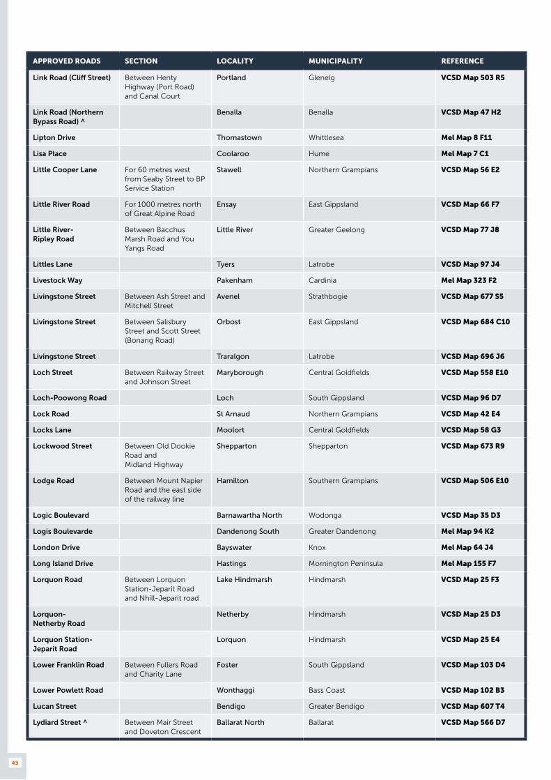
43
APPROVED ROADS SECTION LOCALITY MUNICIPALITY REFERENCE
Link Road (Cliff Street) Between Henty Highway (Port Road) and Canal Court
Portland Glenelg VCSD Map 503 R5
Link Road (Northern Bypass Road) ^
Benalla Benalla VCSD Map 47 H2
Lipton Drive Thomastown Whittlesea Mel Map 8 F11
Lisa Place Coolaroo Hume Mel Map 7 C1
Little Cooper Lane For 60 metres west from Seaby Street to BP Service Station
Stawell Northern Grampians VCSD Map 56 E2
Little River Road For 1000 metres north of Great Alpine Road
Ensay East Gippsland VCSD Map 66 F7
Little River- Ripley Road
Between Bacchus Marsh Road and You Yangs Road
Little River Greater Geelong VCSD Map 77 J8
Littles Lane Tyers Latrobe VCSD Map 97 J4
Livestock Way Pakenham Cardinia Mel Map 323 F2
Livingstone Street Between Ash Street and Mitchell Street
Avenel Strathbogie VCSD Map 677 S5
Livingstone Street Between Salisbury Street and Scott Street (Bonang Road)
Orbost East Gippsland VCSD Map 684 C10
Livingstone Street Traralgon Latrobe VCSD Map 696 J6
Loch Street Between Railway Street and Johnson Street
Maryborough Central Goldfields VCSD Map 558 E10
Loch-Poowong Road Loch South Gippsland VCSD Map 96 D7
Lock Road St Arnaud Northern Grampians VCSD Map 42 E4
Locks Lane Moolort Central Goldfields VCSD Map 58 G3
Lockwood Street Between Old Dookie Road and Midland Highway
Shepparton Shepparton VCSD Map 673 R9
Lodge Road Between Mount Napier Road and the east side of the railway line
Hamilton Southern Grampians VCSD Map 506 E10
Logic Boulevard Barnawartha North Wodonga VCSD Map 35 D3
Logis Boulevarde Dandenong South Greater Dandenong Mel Map 94 K2
London Drive Bayswater Knox Mel Map 64 J4
Long Island Drive Hastings Mornington Peninsula Mel Map 155 F7
Lorquon Road Between Lorquon Station-Jeparit Road and Nhill-Jeparit road
Lake Hindmarsh Hindmarsh VCSD Map 25 F3
Lorquon- Netherby Road
Netherby Hindmarsh VCSD Map 25 D3
Lorquon Station-Jeparit Road
Lorquon Hindmarsh VCSD Map 25 E4
Lower Franklin Road Between Fullers Road and Charity Lane
Foster South Gippsland VCSD Map 103 D4
Lower Powlett Road Wonthaggi Bass Coast VCSD Map 102 B3
Lucan Street Bendigo Greater Bendigo VCSD Map 607 T4
Lydiard Street ^ Between Mair Street and Doveton Crescent
Ballarat North Ballarat VCSD Map 566 D7
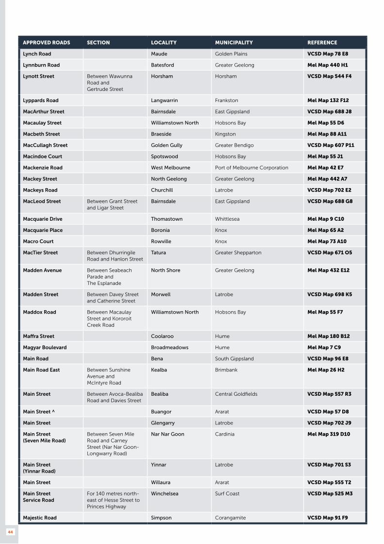
44
APPROVED ROADS SECTION LOCALITY MUNICIPALITY REFERENCE
Lynch Road Maude Golden Plains VCSD Map 78 E8
Lynnburn Road Batesford Greater Geelong Mel Map 440 H1
Lynott Street Between Wawunna Road and Gertrude Street
Horsham Horsham VCSD Map 544 F4
Lyppards Road Langwarrin Frankston Mel Map 132 F12
MacArthur Street Bairnsdale East Gippsland VCSD Map 688 J8
Macaulay Street Williamstown North Hobsons Bay Mel Map 55 D6
Macbeth Street Braeside Kingston Mel Map 88 A11
MacCullagh Street Golden Gully Greater Bendigo VCSD Map 607 P11
Macindoe Court Spotswood Hobsons Bay Mel Map 55 J1
Mackenzie Road West Melbourne Port of Melbourne Corporation Mel Map 42 E7
Mackey Street North Geelong Greater Geelong Mel Map 442 A7
Mackeys Road Churchill Latrobe VCSD Map 702 E2
MacLeod Street Between Grant Street and Ligar Street
Bairnsdale East Gippsland VCSD Map 688 G8
Macquarie Drive Thomastown Whittlesea Mel Map 9 C10
Macquarie Place Boronia Knox Mel Map 65 A2
Macro Court Rowville Knox Mel Map 73 A10
MacTier Street Between Dhurringile Road and Hanlon Street
Tatura Greater Shepparton VCSD Map 671 O5
Madden Avenue Between Seabeach Parade and The Esplanade
North Shore Greater Geelong Mel Map 432 E12
Madden Street Between Davey Street and Catherine Street
Morwell Latrobe VCSD Map 698 K5
Maddox Road Between Macaulay Street and Kororoit Creek Road
Williamstown North Hobsons Bay Mel Map 55 F7
Maffra Street Coolaroo Hume Mel Map 180 B12
Magyar Boulevard Broadmeadows Hume Mel Map 7 C9
Main Road Bena South Gippsland VCSD Map 96 E8
Main Road East Between Sunshine Avenue and McIntyre Road
Kealba Brimbank Mel Map 26 H2
Main Street Between Avoca-Bealiba Road and Davies Street
Bealiba Central Goldfields VCSD Map 557 R3
Main Street ^ Buangor Ararat VCSD Map 57 D8
Main Street Glengarry Latrobe VCSD Map 702 J9
Main Street (Seven Mile Road)
Between Seven Mile Road and Carney Street (Nar Nar Goon-Longwarry Road)
Nar Nar Goon Cardinia Mel Map 319 D10
Main Street (Yinnar Road)
Yinnar Latrobe VCSD Map 701 S3
Main Street Willaura Ararat VCSD Map 555 T2
Main Street Service Road
For 140 metres north-east of Hesse Street to Princes Highway
Winchelsea Surf Coast VCSD Map 525 M3
Majestic Road Simpson Corangamite VCSD Map 91 F9

45
APPROVED ROADS SECTION LOCALITY MUNICIPALITY REFERENCE
Majorca Road ^ Between the railway line and Landrigan Road (Dunach-Eddington Road)
Maryborough Central Goldfields VCSD Map 558 E9
Makland Drive Derrimut Brimbank Mel Map 39 E2
Malakoff Road Between Bridge St (Beechworth-Wangaratta Road) and Flat Rock Road
Beechworth Indigo VCSD Map 659 L4
Malcolm Place Campbellfield Hume Mel Map 7 J5
Malcolm Road Braeside Kingston Mel Map 88 A11
Malcolm Street Between Kidston Parade and Mount Buller Road (Chenery Street)
Mansfield Mansfield VCSD Map 679 M5
Malvern Street Bayswater Knox Mel Map 64 G4
Mansfield Street Between Sparks Avenue and Matisi Street
Thornbury Darebin Mel Map 31 B5
Manuells Blair Road Yallourn North Latrobe VCSD Map 97 H4
Manuels Road Between Manuells Blair Road and Barbor Road
Yallourn North Latrobe VCSD Map 97 H4
Marine Parade Between Frankston-Flinders Road (Western Port Highway) and Barclay Crescent
Hastings Mornington Peninsula Mel Map 154 H5
Mark Anthony Drive Dandenong South Greater Dandenong Mel Map 94 K9
Market Street Between Calder Highway and Reservoir Road
Harcourt Mount Alexander VCSD Map 627 T2
Markets Road Kerang Gannawarra VCSD Map 592 D5
Marlo Place Hallam Casey Mel Map 91 D12
Marretts Road Between Strzelecki Highway (Morwell-Thorpdale Road) and Princes Freeway
Driffield Latrobe VCSD Map 97 G5
Marshall Court Altona Hobsons Bay Mel Map 53 H5
Marshalltown Road Between Surf Coast Highway and Dendle Street
Grovedale Greater Geelong Mel Map 465 J5
Martin Drive Delacombe Ballarat VCSD Map 565 R11
Marungi Road Between Katamatite-Shepparton Road and Inverness Road
Katandra West Greater Shepparton VCSD Map 33 A5
Marwen Drive Derrimut Brimbank Mel Map 39 G7
Mary Street Between Davey Street and Catherine Street
Morwell Latrobe VCSD Map 698 K5
Mary Street Pakenham Cardinia Mel Map 215 J4
Mary Street For 320 metres west of Cypress Street
Stawell Northern Grampians VCSD Map 550 C6
Mason Street Wangaratta Wangaratta VCSD Map 664 A12
Masons Road Beechworth Indigo VCSD Map 35 E8
Mathew Street Between Jubilee Street and Barton Street
Myrtleford Alpine VCSD Map 660 B4

46
APPROVED ROADS SECTION LOCALITY MUNICIPALITY REFERENCE
Matisi Street Thornbury Darebin Mel Map 31 B4
Maxwell Avenue Belmont Greater Geelong Mel Map 451 K12
McAllister Road Swan Hill Swan Hill VCSD Map 586 C4
McClelland Avenue ^ Lara Greater Geelong Mel Map 423 E6
McClelland Drive Eaglehawk Greater Bendigo VCSD Map 603 N6
McClure Street ^ Between Golden Wattle Drive and Tullaroop Road
Maryborough Central Goldfields VCSD Map 558 G4
McCormick Street Churchill Latrobe VCSD Map 702 B3
McCormicks Road For 250 metres from Huntly-Fosterville Road
Axedale Greater Bendigo VCSD Map 31 C9
McCormicks Road From Huntly-Fosterville Road south to mine
Axedale Greater Bendigo VCSD Map 31 C9
McCrows Road Westmere Ararat VCSD Map 74 G5
McDonald Street Between Orchard Street and Bank Street
Numurkah Moira VCSD Map 670 C5
McDonald Way Between Northways Road and Philip Parade
Churchill Latrobe VCSD Map 702 E4
McDonalds Track Between Frys Track and Sayers Track
Hernes Oak Latrobe VCSD Map 97 F6
McDonalds Track ^ Lang Lang Cardinia VCSD Map 96 B6
McDonalds Track Between Saviges Road and Mirboo-North Trafalgar Road
Thorpdale Baw Baw VCSD Map 97 E6
McDougall Road Between Great Ocean Road and Walker Street
Anglesea Surf Coast VCSD Map 526 F3
McDowalls Road Between Piper Road and Victa Road
East Bendigo Greater Bendigo VCSD Map 608 E3
McGeehan Crescent Myrtleford Alpine VCSD Map 660 B4
McGill Street Shepparton Greater Shepparton VCSD Map 673 U5
McGregor Road ^ Between Princes Highway and Princes Freeway inbound on ramp
Pakenham Cardinia Mel Map 317 B9
McGregors Drive Keilor Park Brimbank Mel Map 15 A4
McIntyre Road For 300 metres north from Main Road East to quarry entrance
Kealba Brimbank Mel Map 26 J1
McIntyre Road ^ Between Old Melbourne Road and Mill Road
Lara Greater Geelong Mel Map 423 H2
McIvor Road Between Calder Highway and Reservoir Road
Harcourt Mount Alexander VCSD Map 44 F9
McKenzie Avenue Between Nhill-Yanac Road and Western Highway
Nhill Hindmarsh VCSD Map 25 C7
McKenzie Drive Wendouree Ballarat VCSD Map 561 R10
McKimmies Road Between Plenty Road and Laurie Collins Street
Bundoora Whittlesea Mel Map 9 J7
McKinnon Street Marnoo Northern Grampians VCSD Map 549 S11

47
APPROVED ROADS SECTION LOCALITY MUNICIPALITY REFERENCE
McKoy Street West Wodonga Wodonga VCSD Map 652 C2
McLees Road Between Buffalo River Road and the pine plantation
Buffalo River Alpine VCSD Map 49 C4
McLellan Street Bayswater Knox Mel Map 64 K6
McLeod Street North Geelong Greater Geelong Mel Map 442 A6
McMahon Drive Maffra Wellington VCSD Map 694 B6
McMahon Street Between Howitt Street and Inkerman Street (Wimmera Highway)
St Arnaud Northern Grampians VCSD Map 551 S10
McMahon Street Between Sunraysia Highway (North Western Road) and Mill Street
St Arnaud Northern Grampians VCSD Map 551 R8
McMahon Street Between Riggall Road and Traralgon- Maffra Road
Traralgon Latrobe VCSD Map 697 L5
McMeekin Road Between Albert Street and Strong Street
Warrnambool Warrnambool VCSD Map 514 F6
McMillan Road Echuca Campaspe VCSD Map 596 J10
McMillan Street Lucknow East Gippsland VCSD Map 689 N6
McNairn Road ^ Between Princes Highway and Craigburn Place (Highland Way)
Traralgon Latrobe VCSD Map 697 M7
McNaughton Road Clayton Monash Mel Map 79 G3
McPherson Street Leongatha South Gippsland VCSD Map 710 E7
McQuade Street Morwell Latrobe VCSD Map 699 U6
Melba Avenue ^ Lilydale Yarra Ranges Mel Map 38 D5
Melbourne Road Between Melrose Drive and House Creek
Wodonga Wodonga VCSD Map 652 K4
Mellish Street Beechworth Indigo VCSD Map 659 N6
Melrich Road Bayswater Knox Mel Map 64 K5
Melrose Drive Between Link Road and Apac Drive
Melbourne Airport Melbourne Airport Mel Map 5 D7
Melton Valley Drive Melton Melton VCSD Map 337 E8
Melrose Drive ^ Between Melbourne Road and Moloney Drive
Wodonga Wodonga VCSD Map 652 J4
Melverton Drive Hallam Casey Mel Map 96 H1
Memorial Drive Swan Hill Swan Hill VCSD Map 14 A7
Mercer Drive Melbourne Airport Melbourne Airport Mel Map 5 E8
Meridian Road Between Calder Highway and Sturt Highway
Yelta Mildura VCSD Map 2 H4
Merino Grassdale Road Between Coleraine-Merino Road and Campbell Street
Merino Glenelg VCSD Map 501 T4
Merino Street Laverton North Wyndham Mel Map 40 D10
Merola Way Campbellfield Hume Mel Map 7 G1
Merri Concourse Campbellfield Hume Mel Map 7 J2
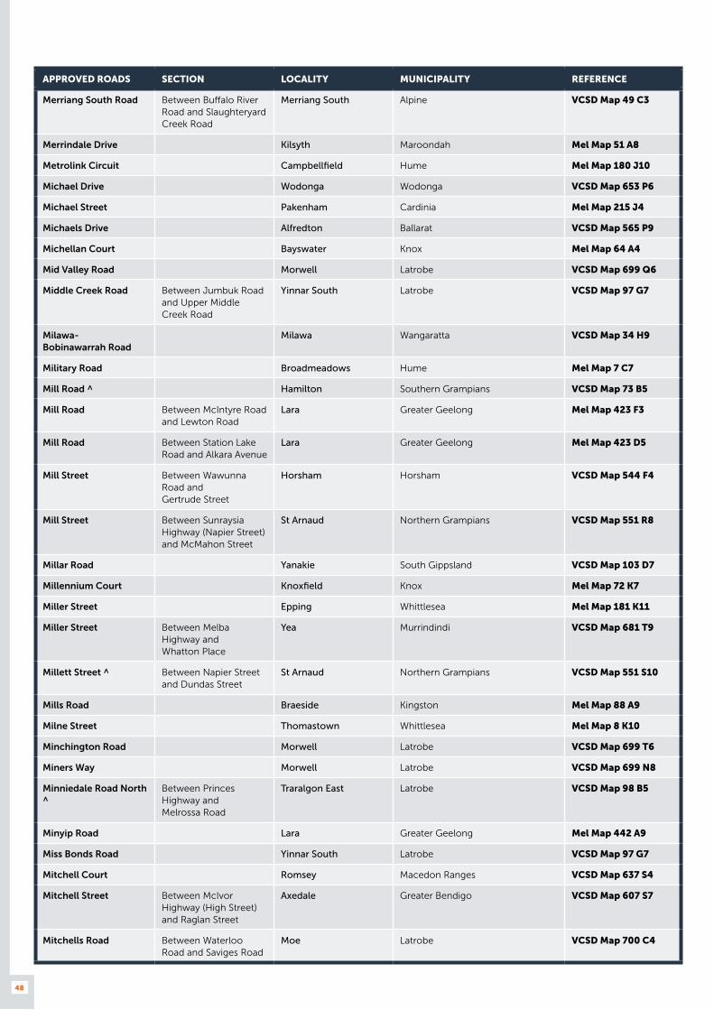
48
APPROVED ROADS SECTION LOCALITY MUNICIPALITY REFERENCE
Merriang South Road Between Buffalo River Road and Slaughteryard Creek Road
Merriang South Alpine VCSD Map 49 C3
Merrindale Drive Kilsyth Maroondah Mel Map 51 A8
Metrolink Circuit Campbellfield Hume Mel Map 180 J10
Michael Drive Wodonga Wodonga VCSD Map 653 P6
Michael Street Pakenham Cardinia Mel Map 215 J4
Michaels Drive Alfredton Ballarat VCSD Map 565 P9
Michellan Court Bayswater Knox Mel Map 64 A4
Mid Valley Road Morwell Latrobe VCSD Map 699 Q6
Middle Creek Road Between Jumbuk Road and Upper Middle Creek Road
Yinnar South Latrobe VCSD Map 97 G7
Milawa- Bobinawarrah Road
Milawa Wangaratta VCSD Map 34 H9
Military Road Broadmeadows Hume Mel Map 7 C7
Mill Road ^ Hamilton Southern Grampians VCSD Map 73 B5
Mill Road Between McIntyre Road and Lewton Road
Lara Greater Geelong Mel Map 423 F3
Mill Road Between Station Lake Road and Alkara Avenue
Lara Greater Geelong Mel Map 423 D5
Mill Street Between Wawunna Road and Gertrude Street
Horsham Horsham VCSD Map 544 F4
Mill Street Between Sunraysia Highway (Napier Street) and McMahon Street
St Arnaud Northern Grampians VCSD Map 551 R8
Millar Road Yanakie South Gippsland VCSD Map 103 D7
Millennium Court Knoxfield Knox Mel Map 72 K7
Miller Street Epping Whittlesea Mel Map 181 K11
Miller Street Between Melba Highway and Whatton Place
Yea Murrindindi VCSD Map 681 T9
Millett Street ^ Between Napier Street and Dundas Street
St Arnaud Northern Grampians VCSD Map 551 S10
Mills Road Braeside Kingston Mel Map 88 A9
Milne Street Thomastown Whittlesea Mel Map 8 K10
Minchington Road Morwell Latrobe VCSD Map 699 T6
Miners Way Morwell Latrobe VCSD Map 699 N8
Minniedale Road North ^
Between Princes Highway and Melrossa Road
Traralgon East Latrobe VCSD Map 98 B5
Minyip Road Lara Greater Geelong Mel Map 442 A9
Miss Bonds Road Yinnar South Latrobe VCSD Map 97 G7
Mitchell Court Romsey Macedon Ranges VCSD Map 637 S4
Mitchell Street Between McIvor Highway (High Street) and Raglan Street
Axedale Greater Bendigo VCSD Map 607 S7
Mitchells Road Between Waterloo Road and Saviges Road
Moe Latrobe VCSD Map 700 C4
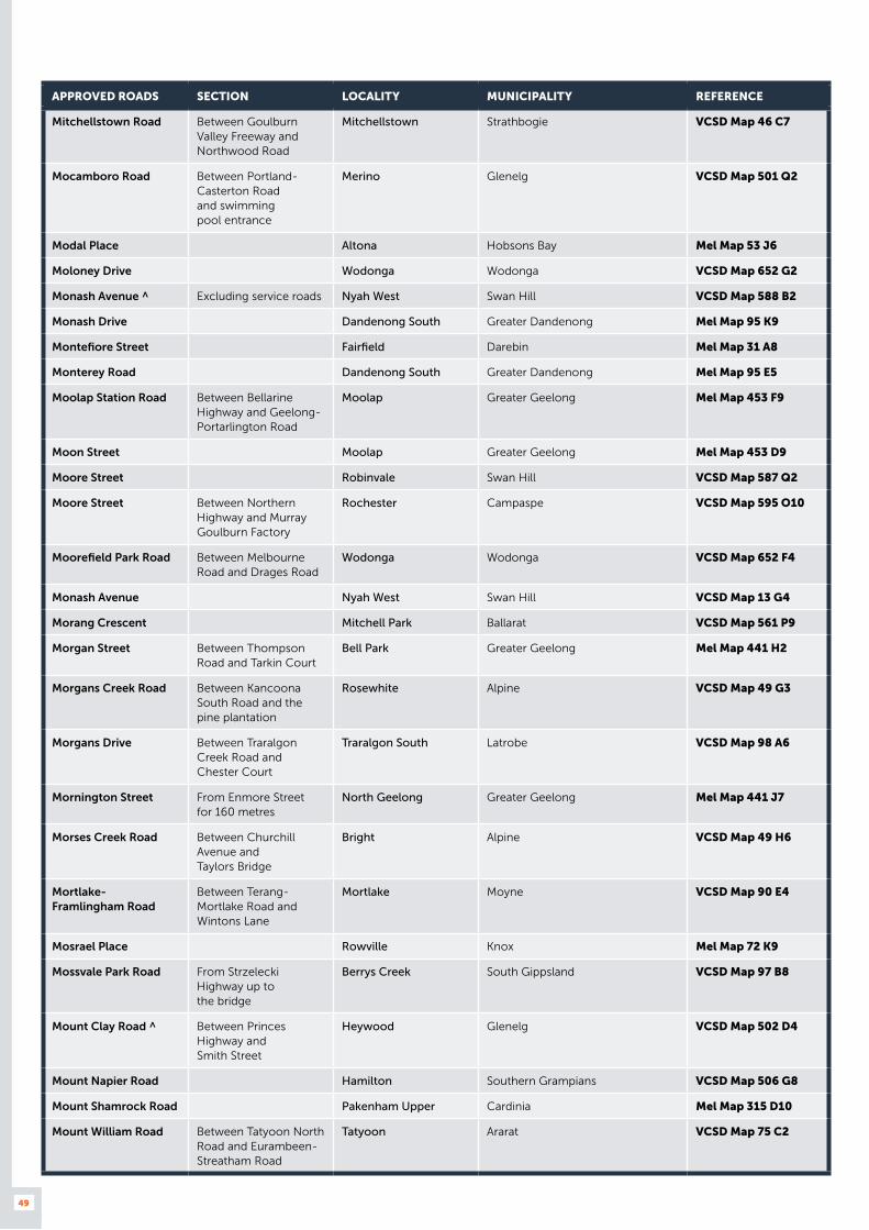
49
APPROVED ROADS SECTION LOCALITY MUNICIPALITY REFERENCE
Mitchellstown Road Between Goulburn Valley Freeway and Northwood Road
Mitchellstown Strathbogie VCSD Map 46 C7
Mocamboro Road Between Portland-Casterton Road and swimming pool entrance
Merino Glenelg VCSD Map 501 Q2
Modal Place Altona Hobsons Bay Mel Map 53 J6
Moloney Drive Wodonga Wodonga VCSD Map 652 G2
Monash Avenue ^ Excluding service roads Nyah West Swan Hill VCSD Map 588 B2
Monash Drive Dandenong South Greater Dandenong Mel Map 95 K9
Montefiore Street Fairfield Darebin Mel Map 31 A8
Monterey Road Dandenong South Greater Dandenong Mel Map 95 E5
Moolap Station Road Between Bellarine Highway and Geelong-Portarlington Road
Moolap Greater Geelong Mel Map 453 F9
Moon Street Moolap Greater Geelong Mel Map 453 D9
Moore Street Robinvale Swan Hill VCSD Map 587 Q2
Moore Street Between Northern Highway and Murray Goulburn Factory
Rochester Campaspe VCSD Map 595 O10
Moorefield Park Road Between Melbourne Road and Drages Road
Wodonga Wodonga VCSD Map 652 F4
Monash Avenue Nyah West Swan Hill VCSD Map 13 G4
Morang Crescent Mitchell Park Ballarat VCSD Map 561 P9
Morgan Street Between Thompson Road and Tarkin Court
Bell Park Greater Geelong Mel Map 441 H2
Morgans Creek Road Between Kancoona South Road and the pine plantation
Rosewhite Alpine VCSD Map 49 G3
Morgans Drive Between Traralgon Creek Road and Chester Court
Traralgon South Latrobe VCSD Map 98 A6
Mornington Street From Enmore Street for 160 metres
North Geelong Greater Geelong Mel Map 441 J7
Morses Creek Road Between Churchill Avenue and Taylors Bridge
Bright Alpine VCSD Map 49 H6
Mortlake- Framlingham Road
Between Terang-Mortlake Road and Wintons Lane
Mortlake Moyne VCSD Map 90 E4
Mosrael Place Rowville Knox Mel Map 72 K9
Mossvale Park Road From Strzelecki Highway up to the bridge
Berrys Creek South Gippsland VCSD Map 97 B8
Mount Clay Road ^ Between Princes Highway and Smith Street
Heywood Glenelg VCSD Map 502 D4
Mount Napier Road Hamilton Southern Grampians VCSD Map 506 G8
Mount Shamrock Road Pakenham Upper Cardinia Mel Map 315 D10
Mount William Road Between Tatyoon North Road and Eurambeen-Streatham Road
Tatyoon Ararat VCSD Map 75 C2
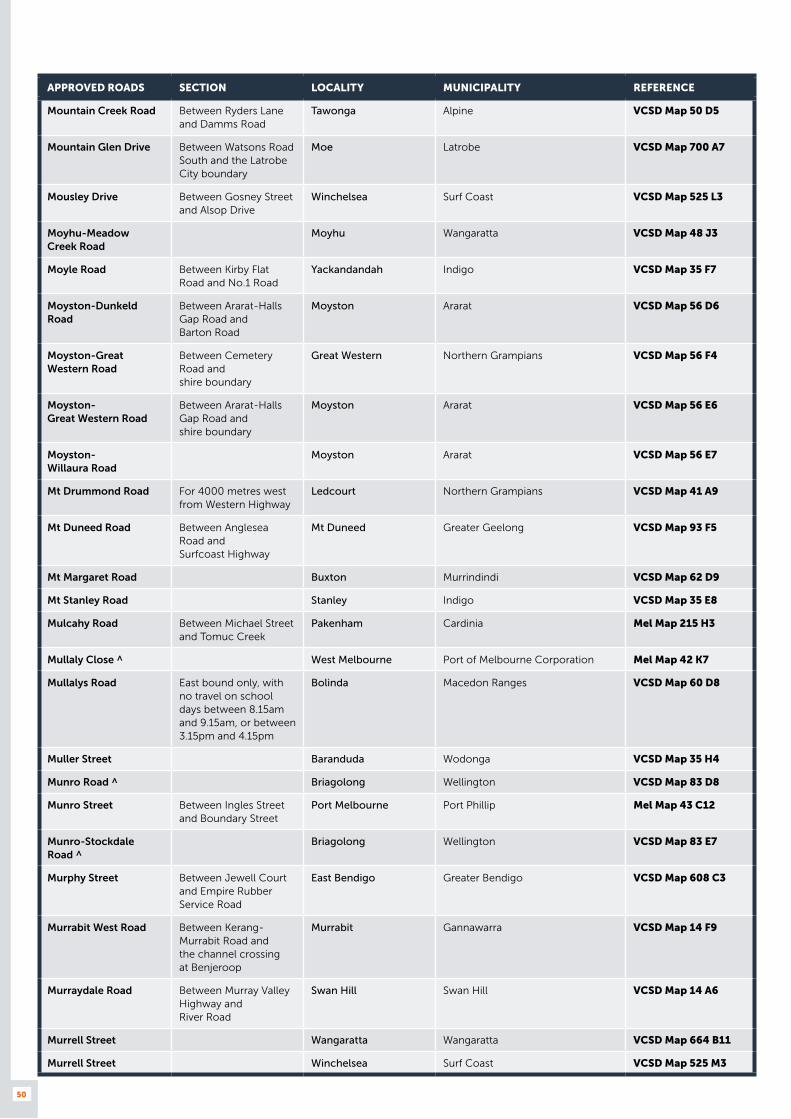
50
APPROVED ROADS SECTION LOCALITY MUNICIPALITY REFERENCE
Mountain Creek Road Between Ryders Lane and Damms Road
Tawonga Alpine VCSD Map 50 D5
Mountain Glen Drive Between Watsons Road South and the Latrobe City boundary
Moe Latrobe VCSD Map 700 A7
Mousley Drive Between Gosney Street and Alsop Drive
Winchelsea Surf Coast VCSD Map 525 L3
Moyhu-Meadow Creek Road
Moyhu Wangaratta VCSD Map 48 J3
Moyle Road Between Kirby Flat Road and No.1 Road
Yackandandah Indigo VCSD Map 35 F7
Moyston-Dunkeld Road
Between Ararat-Halls Gap Road and Barton Road
Moyston Ararat VCSD Map 56 D6
Moyston-Great Western Road
Between Cemetery Road and shire boundary
Great Western Northern Grampians VCSD Map 56 F4
Moyston- Great Western Road
Between Ararat-Halls Gap Road and shire boundary
Moyston Ararat VCSD Map 56 E6
Moyston- Willaura Road
Moyston Ararat VCSD Map 56 E7
Mt Drummond Road For 4000 metres west from Western Highway
Ledcourt Northern Grampians VCSD Map 41 A9
Mt Duneed Road Between Anglesea Road and Surfcoast Highway
Mt Duneed Greater Geelong VCSD Map 93 F5
Mt Margaret Road Buxton Murrindindi VCSD Map 62 D9
Mt Stanley Road Stanley Indigo VCSD Map 35 E8
Mulcahy Road Between Michael Street and Tomuc Creek
Pakenham Cardinia Mel Map 215 H3
Mullaly Close ^ West Melbourne Port of Melbourne Corporation Mel Map 42 K7
Mullalys Road East bound only, with no travel on school days between 8.15am and 9.15am, or between 3.15pm and 4.15pm
Bolinda Macedon Ranges VCSD Map 60 D8
Muller Street Baranduda Wodonga VCSD Map 35 H4
Munro Road ^ Briagolong Wellington VCSD Map 83 D8
Munro Street Between Ingles Street and Boundary Street
Port Melbourne Port Phillip Mel Map 43 C12
Munro-Stockdale Road ^
Briagolong Wellington VCSD Map 83 E7
Murphy Street Between Jewell Court and Empire Rubber Service Road
East Bendigo Greater Bendigo VCSD Map 608 C3
Murrabit West Road Between Kerang-Murrabit Road and the channel crossing at Benjeroop
Murrabit Gannawarra VCSD Map 14 F9
Murraydale Road Between Murray Valley Highway and River Road
Swan Hill Swan Hill VCSD Map 14 A6
Murrell Street Wangaratta Wangaratta VCSD Map 664 B11
Murrell Street Winchelsea Surf Coast VCSD Map 525 M3
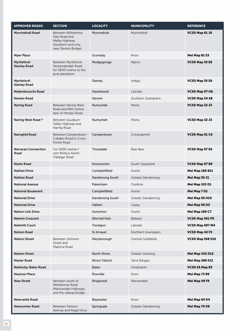
51
APPROVED ROADS SECTION LOCALITY MUNICIPALITY REFERENCE
Murrindindi Road Between Wilhelmina Falls Road and Melba Highway (Southern end only near Devlins Bridge)
Murrindindi Murrindindi VCSD Map 61 J6
Myer Place Scoresby Knox Mel Map 81 E3
Myrtleford- Stanley Road
Between Myrtleford-Yackandandah Road for 3600 metres to the pine plantation
Mudgegonga Alpine VCSD Map 35 E8
Myrtleford- Stanley Road
Stanley Indigo VCSD Map 35 E8
Nadenbouschs Road Hazelwood Latrobe VCSD Map 97 H6
Nareen Road Nareen Southern Grampians VCSD Map 54 A8
Naring Road Between Naring West Road and 800 metres east of Hendys Road
Numurkah Moira VCSD Map 32 J3
Naring West Road ^ Between Goulburn Valley Highway and Naring Road
Numurkah Moira VCSD Map 32 J3
Naroghid Road Between Camperdown-Cobden Road to Cross Forest Road
Camperdown Corangamite VCSD Map 91 C6
Narracan Connection Road
For 2000 metres f rom Mirboo North-Trafalgar Road
Thorpdale Baw Baw VCSD Map 97 E6
Nashs Road Koorooman South Gippsland VCSD Map 97 B9
Nathan Drive Campbellfield Hume Mel Map 180 B11
Nathan Road Dandenong South Greater Dandenong Mel Map 95 J1
National Avenue Pakenham Cardinia Mel Map 323 D1
National Boulevard Campbellfield Hume Mel Map 7 D1
National Drive Dandenong South Greater Dandenong Mel Map 95 H10
National Drive Hallam Casey Mel Map 96 D3
Nation Link Drive Somerton Hume Mel Map 180 C7
Neerim Crescent Mitchell Park Ballarat VCSD Map 561 P9
Nefertiti Court Traralgon Latrobe VCSD Map 697 M4
Nelson Road St Arnaud Northern Grampians VCSD Map 42 F3
Nelson Street Between Johnson Street and Majorca Road
Maryborough Central Goldfields VCSD Map 558 E10
Nelson Street North Shore Greater Geelong Mel Map 432 D12
Nester Road Woori Yallock Yarra Ranges Mel Map 286 E12
Netherby-Baker Road Baker Hindmarsh VCSD 25 Map B3
Neutron Place Rowville Knox Mel Map 73 B9
New Street Between south of Whitehorse Road (Maroondah Highway) and the railway bridge
Ringwood Maroondah Mel Map 49 F9
Newcastle Road Bayswater Knox Mel Map 64 K4
Newcomen Road Between Parsons Avenue and Regal Drive
Springvale Greater Dandenong Mel Map 79 K8
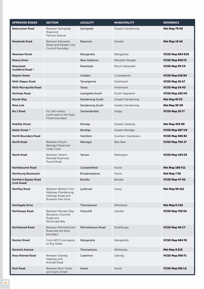
52
APPROVED ROADS SECTION LOCALITY MUNICIPALITY REFERENCE
Newcomen Road Between Springvale Road and Parsons Avenue
Springvale Greater Dandenong Mel Map 79 K8
Newlands Road Between Edwardes Street and Darebin City Council boundary
Reservoir Darebin Mel Map 18 A6
Newman Street Wangaratta Wangaratta VCSD Map 664 D10
Newry Drive New Gisborne Macedon Ranges VCSD Map 636 F2
Newstead- Guildford Road ^
Newstead Mount Alexander VCSD Map 59 C4
Neylon Street Cobden Corangamite VCSD Map 518 B4
Nhill-Diapur Road Tarranginnie Hindmarsh VCSD Map 25 A7
Nhill-Murrayville Road Yanac Hindmarsh VCSD Map 24 H3
Nicholas Road Leongatha South South Gippsland VCSD Map 102 H3
Nicole Way Dandenong South Greater Dandenong Mel Map 95 E3
Nina Link Dandenong South Greater Dandenong Mel Map 95 H9
No.1 Road For 245 metres north west of the State Forest boundary
Yackandandah Indigo VCSD Map 35 F7
Nobility Street Moolap Greater Geelong Mel Map 453 D9
Nolan Street ^ Bendigo Greater Bendigo VCSD Map 607 U4
North Boundary Road Hamilton Southern Grampians VCSD Map 506 B3
North Road Between Drouin-Warragul Road and Lindy Court
Warragul Baw Baw VCSD Map 704 J7
North Road Between Yarram-Morwell Road and Pound Road
Yarram Wellington VCSD Map 104 D3
Northbourne Road Campbellfield Hume Mel Map 180 F11
Northcorp Boulevard Broadmeadows Hume Mel Map 7 E9
Northern Bypass Road (Link Road)
Benalla Benalla VCSD Map 47 H2
Northey Road Between Western Port Highway (Dandenong- Hastings Road) and Business Park Drive
Lynbrook Casey Mel Map 96 A11
Northgate Drive Thomastown Whittlesea Mel Map 9 C10
Northways Road Between Monash Way (Boolarra-Churchill Road) and McDonald Way
Churchill Latrobe VCSD Map 702 E4
Northwood Road Between Mitchellstown Road and the Shire boundary
Mitchellstown Road Strathbogie VCSD Map 46 C7
Norton Street From APCO site egress to Roy Street
Wangaratta Wangaratta VCSD Map 664 F8
Norwich Avenue Thomastown Whittlesea Mel Map 8 E10
Noss Retreat Road Between Glenelg Highway and Arundel Road
Casterton Glenelg VCSD Map 500 F1
Nott Road Between Burn Street and Grano Street
Ararat Ararat VCSD Map 555 L6
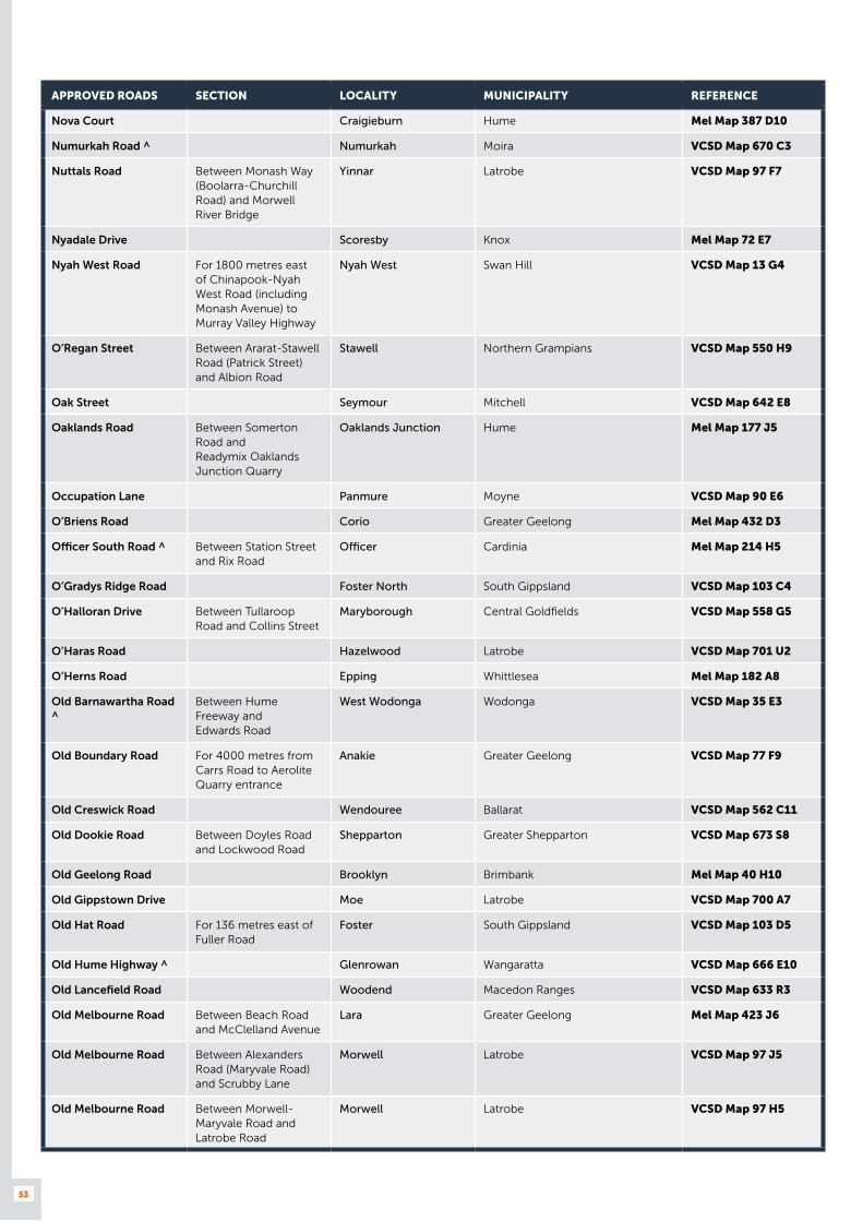
53
APPROVED ROADS SECTION LOCALITY MUNICIPALITY REFERENCE
Nova Court Craigieburn Hume Mel Map 387 D10
Numurkah Road ^ Numurkah Moira VCSD Map 670 C3
Nuttals Road Between Monash Way (Boolarra-Churchill Road) and Morwell River Bridge
Yinnar Latrobe VCSD Map 97 F7
Nyadale Drive Scoresby Knox Mel Map 72 E7
Nyah West Road For 1800 metres east of Chinapook-Nyah West Road (including Monash Avenue) to Murray Valley Highway
Nyah West Swan Hill VCSD Map 13 G4
O’Regan Street Between Ararat-Stawell Road (Patrick Street) and Albion Road
Stawell Northern Grampians VCSD Map 550 H9
Oak Street Seymour Mitchell VCSD Map 642 E8
Oaklands Road Between Somerton Road and Readymix Oaklands Junction Quarry
Oaklands Junction Hume Mel Map 177 J5
Occupation Lane Panmure Moyne VCSD Map 90 E6
O’Briens Road Corio Greater Geelong Mel Map 432 D3
Officer South Road ^ Between Station Street and Rix Road
Officer Cardinia Mel Map 214 H5
O’Gradys Ridge Road Foster North South Gippsland VCSD Map 103 C4
O’Halloran Drive Between Tullaroop Road and Collins Street
Maryborough Central Goldfields VCSD Map 558 G5
O’Haras Road Hazelwood Latrobe VCSD Map 701 U2
O’Herns Road Epping Whittlesea Mel Map 182 A8
Old Barnawartha Road ^
Between Hume Freeway and Edwards Road
West Wodonga Wodonga VCSD Map 35 E3
Old Boundary Road For 4000 metres from Carrs Road to Aerolite Quarry entrance
Anakie Greater Geelong VCSD Map 77 F9
Old Creswick Road Wendouree Ballarat VCSD Map 562 C11
Old Dookie Road Between Doyles Road and Lockwood Road
Shepparton Greater Shepparton VCSD Map 673 S8
Old Geelong Road Brooklyn Brimbank Mel Map 40 H10
Old Gippstown Drive Moe Latrobe VCSD Map 700 A7
Old Hat Road For 136 metres east of Fuller Road
Foster South Gippsland VCSD Map 103 D5
Old Hume Highway ^ Glenrowan Wangaratta VCSD Map 666 E10
Old Lancefield Road Woodend Macedon Ranges VCSD Map 633 R3
Old Melbourne Road Between Beach Road and McClelland Avenue
Lara Greater Geelong Mel Map 423 J6
Old Melbourne Road Between Alexanders Road (Maryvale Road) and Scrubby Lane
Morwell Latrobe VCSD Map 97 J5
Old Melbourne Road Between Morwell-Maryvale Road and Latrobe Road
Morwell Latrobe VCSD Map 97 H5
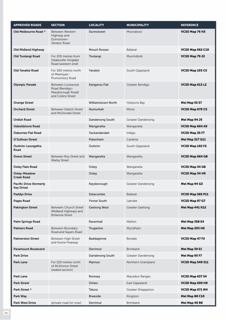
54
APPROVED ROADS SECTION LOCALITY MUNICIPALITY REFERENCE
Old Melbourne Road ^ Between Western Highway and Dunnstown- Yendon Road
Dunnstown Moorabool VCSD Map 76 H3
Old Midland Highway Mount Rowan Ballarat VCSD Map 562 C10
Old Toolangi Road For 200 metres from Healesville-Kinglake Road (western end)
Toolangi Murrindindi VCSD Map 79 J2
Old Yanakie Road For 300 metres north of Meeniyan-Promontory Road
Yanakie South Gippsland VCSD Map 103 C5
Olympic Parade Between Lockwood Road (Bendigo-Maryborough Road) and Collins Street
Kangaroo Flat Greater Bendigo VCSD Map 613 L2
Orange Street Williamstown North Hobsons Bay Mel Map 55 E7
Orchard Street Between Station Street and McDonald Street
Numurkah Moira VCSD Map 670 C5
Ordish Road Dandenong South Greater Dandenong Mel Map 94 J5
Osboldstone Road Wangaratta Wangaratta VCSD Map 664 A9
Osbornes Flat Road Yackandandah Indigo VCSD Map 35 F7
O’Sullivan Street Pakenham Cardinia Mel Map 317 G11
Outtrim-Leongatha Road
Outtrim South Gippsland VCSD Map 102 F2
Ovens Street Between Roy Street and Warby Street
Wangaratta Wangaratta VCSD Map 664 G8
Oxley Flats Road Oxley Wangaratta VCSD Map 34 G8
Oxley-Meadow Creek Road
Oxley Wangaratta VCSD Map 34 H9
Pacific Drive (formerly Key Drive)
Keysborough Greater Dandenong Mel Map 94 G3
Paddys Drive Delacombe Ballarat VCSD Map 565 P11
Pages Road Yinnar South Latrobe VCSD Map 97 G7
Pakington Street Between Church Street (Midland Highway) and Britannia Street
Geelong West Greater Geelong Mel Map 441 K12
Palm Springs Road Ravenhall Melton Mel Map 358 E4
Palmers Road Between Boundary Road and Sayers Road
Truganina Wyndham Mel Map 203 H6
Palmerston Street Between High Street and Hume Freeway
Baddaginnie Benalla VCSD Map 47 F3
Paramount Boulevard Derrimut Brimbank Mel Map 39 E1
Park Drive Dandenong South Greater Dandenong Mel Map 95 F7
Park Lane For 120 metres north of McKinnon Street (sealed section)
Marnoo Northern Grampians VCSD Map 549 S11
Park Lane Romsey Macedon Ranges VCSD Map 637 S4
Park Street Omeo East Gippsland VCSD Map 690 H9
Park Street ^ Tatura Greater Shepparton VCSD Map 671 M4
Park Way Braeside Kingston Mel Map 88 C10
Park West Drive (private road for now) Derrimut Brimbank Mel Map 40 B8
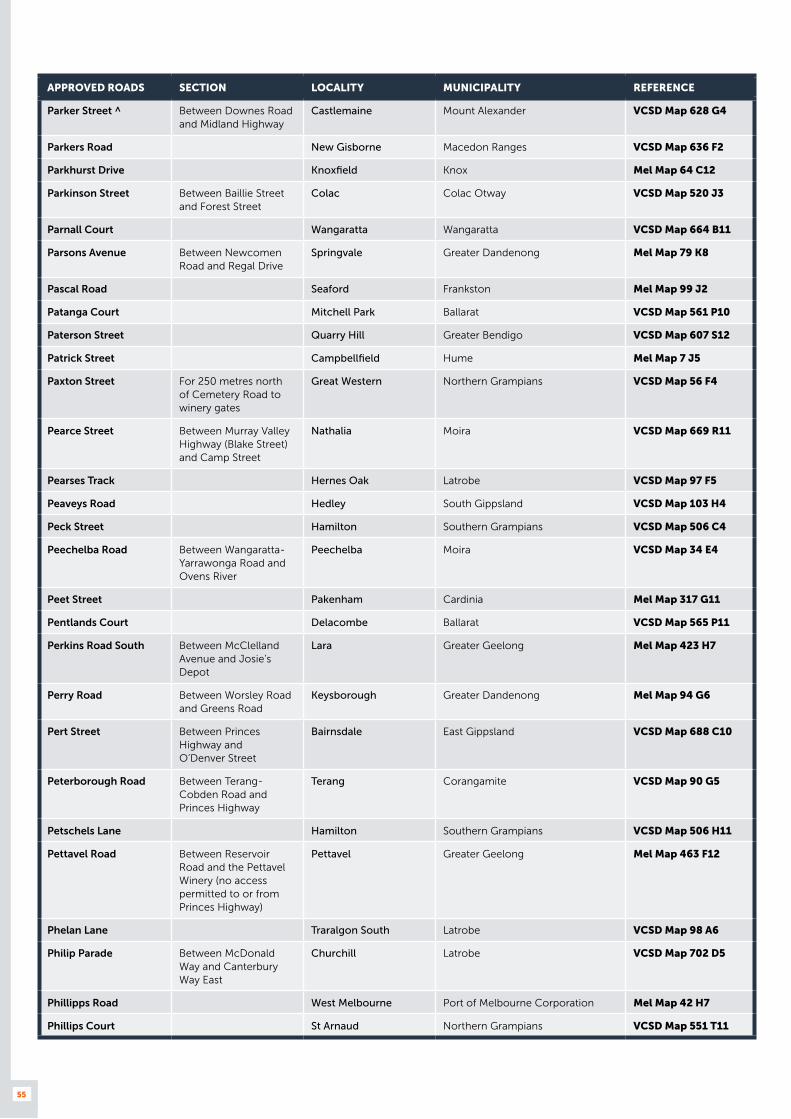
55
APPROVED ROADS SECTION LOCALITY MUNICIPALITY REFERENCE
Parker Street ^ Between Downes Road and Midland Highway
Castlemaine Mount Alexander VCSD Map 628 G4
Parkers Road New Gisborne Macedon Ranges VCSD Map 636 F2
Parkhurst Drive Knoxfield Knox Mel Map 64 C12
Parkinson Street Between Baillie Street and Forest Street
Colac Colac Otway VCSD Map 520 J3
Parnall Court Wangaratta Wangaratta VCSD Map 664 B11
Parsons Avenue Between Newcomen Road and Regal Drive
Springvale Greater Dandenong Mel Map 79 K8
Pascal Road Seaford Frankston Mel Map 99 J2
Patanga Court Mitchell Park Ballarat VCSD Map 561 P10
Paterson Street Quarry Hill Greater Bendigo VCSD Map 607 S12
Patrick Street Campbellfield Hume Mel Map 7 J5
Paxton Street For 250 metres north of Cemetery Road to winery gates
Great Western Northern Grampians VCSD Map 56 F4
Pearce Street Between Murray Valley Highway (Blake Street) and Camp Street
Nathalia Moira VCSD Map 669 R11
Pearses Track Hernes Oak Latrobe VCSD Map 97 F5
Peaveys Road Hedley South Gippsland VCSD Map 103 H4
Peck Street Hamilton Southern Grampians VCSD Map 506 C4
Peechelba Road Between Wangaratta-Yarrawonga Road and Ovens River
Peechelba Moira VCSD Map 34 E4
Peet Street Pakenham Cardinia Mel Map 317 G11
Pentlands Court Delacombe Ballarat VCSD Map 565 P11
Perkins Road South Between McClelland Avenue and Josie’s Depot
Lara Greater Geelong Mel Map 423 H7
Perry Road Between Worsley Road and Greens Road
Keysborough Greater Dandenong Mel Map 94 G6
Pert Street Between Princes Highway and O’Denver Street
Bairnsdale East Gippsland VCSD Map 688 C10
Peterborough Road Between Terang-Cobden Road and Princes Highway
Terang Corangamite VCSD Map 90 G5
Petschels Lane Hamilton Southern Grampians VCSD Map 506 H11
Pettavel Road Between Reservoir Road and the Pettavel Winery (no access permitted to or from Princes Highway)
Pettavel Greater Geelong Mel Map 463 F12
Phelan Lane Traralgon South Latrobe VCSD Map 98 A6
Philip Parade Between McDonald Way and Canterbury Way East
Churchill Latrobe VCSD Map 702 D5
Phillipps Road West Melbourne Port of Melbourne Corporation Mel Map 42 H7
Phillips Court St Arnaud Northern Grampians VCSD Map 551 T11
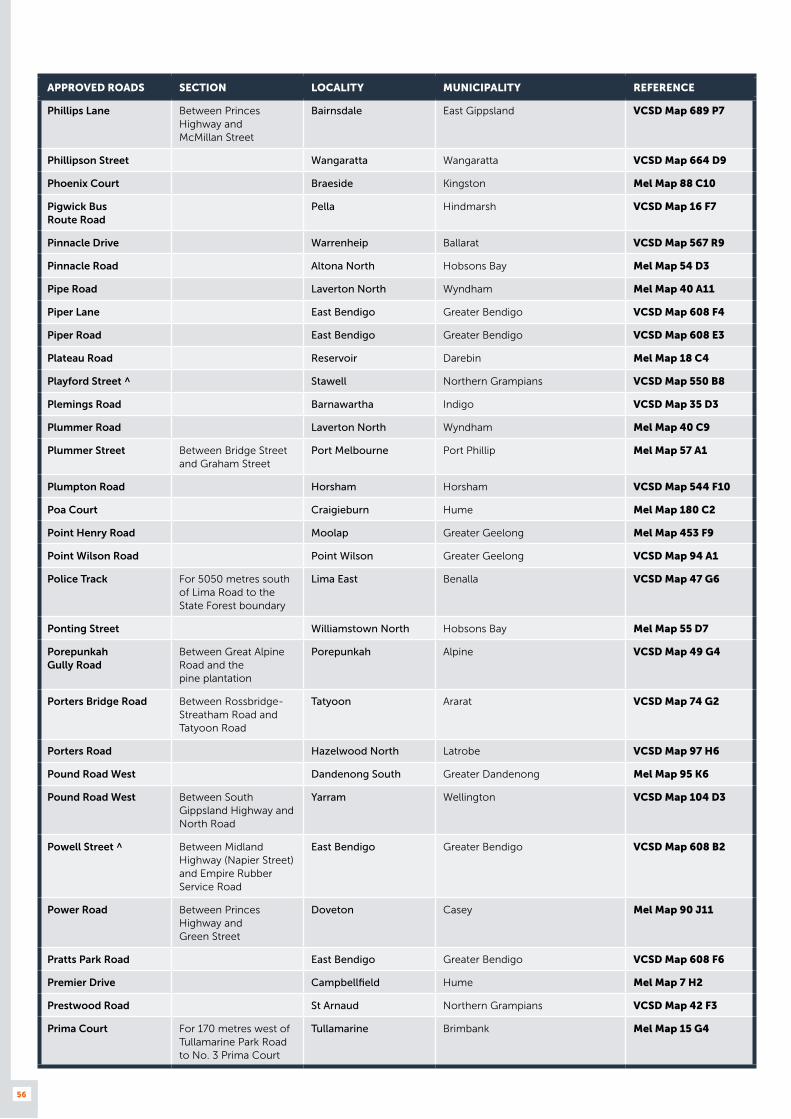
56
APPROVED ROADS SECTION LOCALITY MUNICIPALITY REFERENCE
Phillips Lane Between Princes Highway and McMillan Street
Bairnsdale East Gippsland VCSD Map 689 P7
Phillipson Street Wangaratta Wangaratta VCSD Map 664 D9
Phoenix Court Braeside Kingston Mel Map 88 C10
Pigwick Bus Route Road
Pella Hindmarsh VCSD Map 16 F7
Pinnacle Drive Warrenheip Ballarat VCSD Map 567 R9
Pinnacle Road Altona North Hobsons Bay Mel Map 54 D3
Pipe Road Laverton North Wyndham Mel Map 40 A11
Piper Lane East Bendigo Greater Bendigo VCSD Map 608 F4
Piper Road East Bendigo Greater Bendigo VCSD Map 608 E3
Plateau Road Reservoir Darebin Mel Map 18 C4
Playford Street ^ Stawell Northern Grampians VCSD Map 550 B8
Plemings Road Barnawartha Indigo VCSD Map 35 D3
Plummer Road Laverton North Wyndham Mel Map 40 C9
Plummer Street Between Bridge Street and Graham Street
Port Melbourne Port Phillip Mel Map 57 A1
Plumpton Road Horsham Horsham VCSD Map 544 F10
Poa Court Craigieburn Hume Mel Map 180 C2
Point Henry Road Moolap Greater Geelong Mel Map 453 F9
Point Wilson Road Point Wilson Greater Geelong VCSD Map 94 A1
Police Track For 5050 metres south of Lima Road to the State Forest boundary
Lima East Benalla VCSD Map 47 G6
Ponting Street Williamstown North Hobsons Bay Mel Map 55 D7
Porepunkah Gully Road
Between Great Alpine Road and the pine plantation
Porepunkah Alpine VCSD Map 49 G4
Porters Bridge Road Between Rossbridge-Streatham Road and Tatyoon Road
Tatyoon Ararat VCSD Map 74 G2
Porters Road Hazelwood North Latrobe VCSD Map 97 H6
Pound Road West Dandenong South Greater Dandenong Mel Map 95 K6
Pound Road West Between South Gippsland Highway and North Road
Yarram Wellington VCSD Map 104 D3
Powell Street ^ Between Midland Highway (Napier Street) and Empire Rubber Service Road
East Bendigo Greater Bendigo VCSD Map 608 B2
Power Road Between Princes Highway and Green Street
Doveton Casey Mel Map 90 J11
Pratts Park Road East Bendigo Greater Bendigo VCSD Map 608 F6
Premier Drive Campbellfield Hume Mel Map 7 H2
Prestwood Road St Arnaud Northern Grampians VCSD Map 42 F3
Prima Court For 170 metres west of Tullamarine Park Road to No. 3 Prima Court
Tullamarine Brimbank Mel Map 15 G4

57
APPROVED ROADS SECTION LOCALITY MUNICIPALITY REFERENCE
Princes Drive Service Road
Between Bridle Road and Alexanders Road (Maryvale Road)
Morwell Latrobe VCSD Map 699 R6
Princes Highway Service Road
Between Hallam Road (Hallam South Road) and Wedgewood Road
Hallam Casey Mel Map 96 F1
Princes Highway North Service Road
Between Eastern Road and Rocla Road
Traralgon East Latrobe VCSD Map 697 N5
Princes Highway North Service Road
Between Rocla Road and east of Leesons Road
Traralgon East Latrobe VCSD Map 697 O4
Princes Street Between High Street and Elizabeth Street
Ararat Ararat VCSD Map 554 F9
Princes Street South Ararat Ararat VCSD Map 554 F10
Pringles Road Anakie Greater Geelong VCSD Map 77 F9
Produce Drive Dandenong South Greater Dandenong Mel Map 95 F9
Production Drive Alfredton Ballarat VCSD Map 565 M4
Production Drive Campbellfield Hume Mel Map 7 J4
Progress Street ^ Dandenong South Greater Dandenong Mel Map 90 J12
Prohasky Street Port Melbourne Port Phillip Mel Map 56 H2
Propodollah Road ^ Nhill Hindmarsh VCSD Map 25 C6
Prosperity Drive Corio Greater Geelong Mel Map 432 E2
Prouses Road ^ Between Bright Street and Nolan Street
North Bendigo Greater Bendigo VCSD Map 607 R1
Proximity Drive Sunshine West Brimbank Mel Map 40 E7
Pullut East Road ^ Pullut Hindmarsh VCSD Map 26 1C
Pullut West Road Pullut Hindmarsh VCSD Map 26 1B
Purcell Street Between Ashenden Street and St Georges Road
Shepparton Greater Shepparton VCSD Map 673 P10
Purton Road Pakenham Cardinia Mel Map 215 K4
Purvis Road Yallourn North Latrobe VCSD Map 97 F4
Quality Drive Dandenong South Greater Dandenong Mel Map 95 B6
Quantum Close Dandenong South Greater Dandenong Mel Map 95 K7
Quarry Road Between Cumnock Road and Back Quarry Road
Lake Boga Swan Hill VCSD Map 20 A2
Quarry Road Between Madeira Packet Road and the end of the road
Portland Glenelg VCSD Map 88 B8
Quarry Road Yallourn North Latrobe VCSD Map 97 G3
Quarry Road ^ Cosgrove Greater Shepparton VCSD Map 33 B7
Queen Street Between High Street and Elizabeth Street
Ararat Ararat VCSD Map 554 F8
Queen Street Between Osburn Street and Bradford Street
Wodonga Wodonga VCSD Map 653 O5
Queen Street South Ararat Ararat VCSD Map 554 E11
Queens Avenue Between Sturt Street and Inkerman Street (Wimmera Highway)
St Arnaud Northern Grampians VCSD Map 551 R10

58
APPROVED ROADS SECTION LOCALITY MUNICIPALITY REFERENCE
Quest Court Craigieburn Hume Mel Map 387 D10
Quin Drive Swan Hill Swan Hill VCSD Map 586 C5
Racecourse Road For 330 metres west of Bass Highway
Leongatha South Gippsland VCSD Map 96 G9
Racecourse Road ^ Between Commercial Road (Midland Highway) and Gillies Street
Benalla Benalla VCSD Map 663 P1
Racecourse Road Between Beechworth-Chiltern Main Road and Barambogie Road
Chiltern Indigo VCSD Map 35 B4
Racecourse Road Between Cobram-Koonoomoo Road and Harris Road
Cobram Moira VCSD Map 23 C8
Racecourse Road ^ Between Goulburn Valley Highway (High Street) and McDonalds Road
Nagambie Strathbogie VCSD Map 46 D6
Radford Road Between Edwardes Street and Vickers Street
Reservoir Darebin Mel Map 18 B4
Radiata Road Dartmoor Glenelg VCSD Map 501 L3
Radnor Drive Derrimut Brimbank Mel Map 25 G11
Raglan Street ^ Between Princes Highway and Saleyards Road
Sale Wellington VCSD Map 693 O4
Railway Avenue Glengarry Latrobe VCSD Map 702 J11
Railway Parade West of Hunter Road Healesville Yarra Ranges Mel Map 277 K1
Railway Street Between Stoneham Drive and Gillies Street
Maryborough Central Goldfields VCSD Map 558 E9
Railway Street Between Bow Street and Lake Street
Rainbow Hindmarsh VCSD Map 545 T9
Rainbow Rises Road Rainbow Hindmarsh VCSD Map 16 H8
Ramage Street Bayswater Knox Mel Map 64 K4
Randor Street Campbellfield Hume Mel Map 7 H3
Rapid Way Pakenham Cardinia Mel Map 317 H11
Raymond Road Laverton North Wyndham Mel Map 40 B9
Red Hill Road Beechworth Indigo VCSD Map 659 R4
Redwood Drive Between Boundary Road and Lower Dandenong Road
Dingley Village Kingston Mel Map 88 A6
Reefs Road For 450 metres west of Leviathan Road
Stawell Northern Grampians VCSD Map 550 J8
Refinery Road North Shore Greater Geelong Mel Map 432 E8
Regal Drive Springvale Greater Dandenong Mel Map 79 K8
Regional Drive Somerton Hume Mel Map 180 D8
Reid Street Bayswater Knox Mel Map 64 J6
Reid Way Melbourne Airport Melbourne Airport Mel Map 5 B12
Reids Way Wooragee Indigo VCSD Map 35 C6
Reilly And Allans Road For 1750 metres from Nerrena Road
Nerrena South Gippsland VCSD Map 103 A2
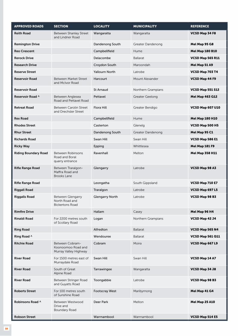
59
APPROVED ROADS SECTION LOCALITY MUNICIPALITY REFERENCE
Reith Road Between Shanley Street and Lindner Road
Wangaratta Wangaratta VCSD Map 34 F8
Remington Drive Dandenong South Greater Dandenong Mel Map 95 G8
Reo Crescent Campbellfield Hume Mel Map 180 B10
Rerock Drive Delacombe Ballarat VCSD Map 565 R11
Research Drive Croydon South Maroondah Mel Map 51 A9
Reserve Street Yallourn North Latrobe VCSD Map 703 T4
Reservoir Road Between Market Street and McIvor Road
Harcourt Mount Alexander VCSD Map 44 F9
Reservoir Road St Arnaud Northern Grampians VCSD Map 551 S12
Reservoir Road ^ Between Anglesea Road and Pettavel Road
Pettavel Greater Geelong Mel Map 463 G12
Retreat Road Between Carolin Street and Drechsler Street
Flora Hill Greater Bendigo VCSD Map 607 U10
Rex Road Campbellfield Hume Mel Map 180 H10
Rhodes Street Casterton Glenelg VCSD Map 500 H5
Rhur Street Dandenong South Greater Dandenong Mel Map 95 C1
Richards Road Swan Hill Swan Hill VCSD Map 586 E1
Ricky Way Epping Whittlesea Mel Map 181 F9
Riding Boundary Road Between Robinsons Road and Boral quarry entrance
Ravenhall Melton Mel Map 358 H11
Rifle Range Road Between Traralgon-Maffra Road and Brooks Lane
Glengarry Latrobe VCSD Map 98 A3
Rifle Range Road Leongatha South Gippsland VCSD Map 710 E7
Riggall Road Traralgon Latrobe VCSD Map 697 L5
Riggalls Road Between Glengarry North Road and Bickertons Road
Glengarry North Latrobe VCSD Map 98 B3
Rimfire Drive Hallam Casey Mel Map 96 H4
Rinaldi Road For 2200 metres south of Scollary Road
Logan Northern Grampians VCSD Map 42 J4
Ring Road Alfredton Ballarat VCSD Map 565 N4
Ring Road ^ Wendouree Ballarat VCSD Map 561 Q11
Ritchie Road Between Cobram-Koonoomoo Road and Murray Valley Highway
Cobram Moira VCSD Map 667 L9
River Road For 1500 metres east of Murraydale Road
Swan Hill Swan Hill VCSD Map 14 A7
River Road South of Great Alpine Road
Tarrawingee Wangaratta VCSD Map 34 J8
River Road Between Stringer Road and Guyatts Road
Toongabbie Latrobe VCSD Map 98 B3
Roberts Street For 100 metres south of Sunshine Road
Footscray West Maribyrnong Mel Map 41 G4
Robinsons Road ^ Between Westwood Drive and Boundary Road
Deer Park Melton Mel Map 25 A10
Robson Street Warrnambool Warrnambool VCSD Map 514 E5
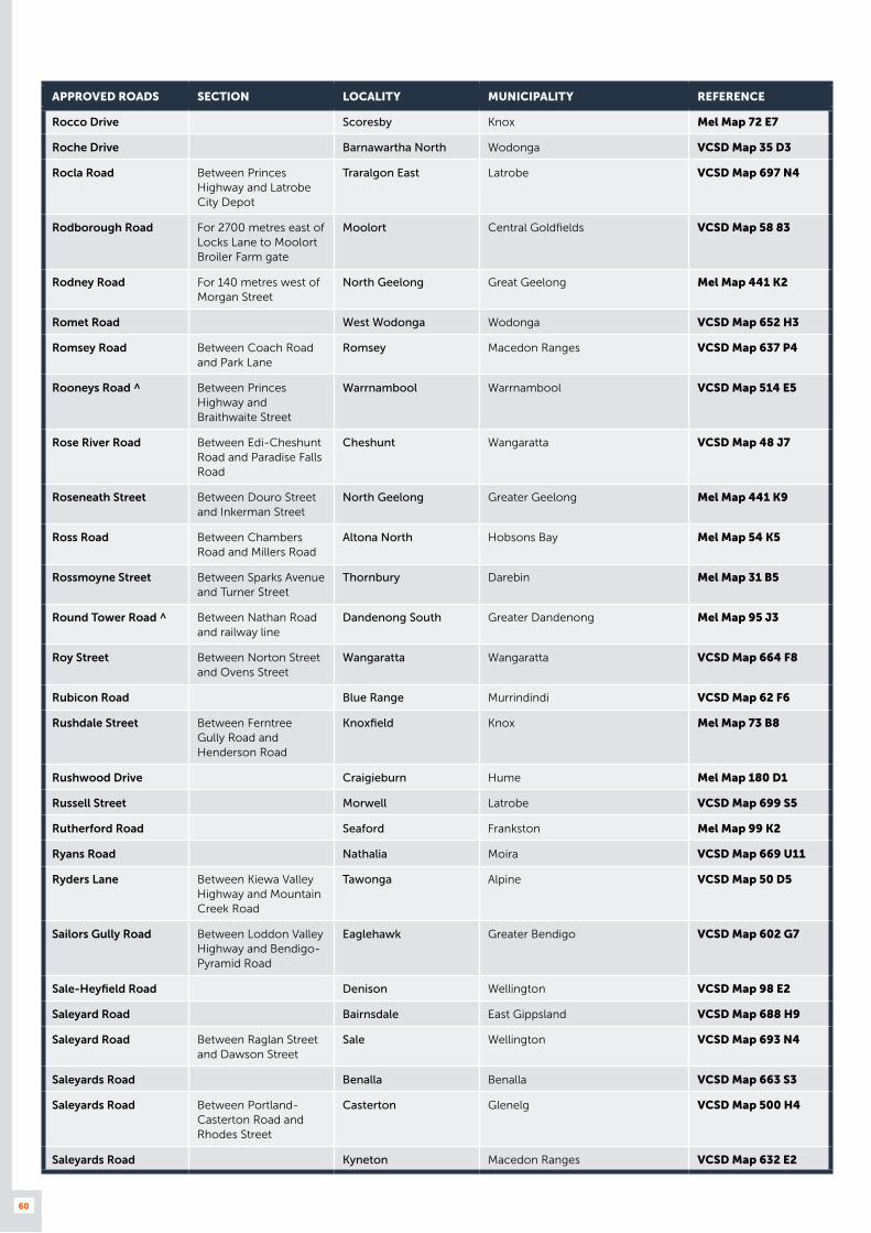
60
APPROVED ROADS SECTION LOCALITY MUNICIPALITY REFERENCE
Rocco Drive Scoresby Knox Mel Map 72 E7
Roche Drive Barnawartha North Wodonga VCSD Map 35 D3
Rocla Road Between Princes Highway and Latrobe City Depot
Traralgon East Latrobe VCSD Map 697 N4
Rodborough Road For 2700 metres east of Locks Lane to Moolort Broiler Farm gate
Moolort Central Goldfields VCSD Map 58 83
Rodney Road For 140 metres west of Morgan Street
North Geelong Great Geelong Mel Map 441 K2
Romet Road West Wodonga Wodonga VCSD Map 652 H3
Romsey Road Between Coach Road and Park Lane
Romsey Macedon Ranges VCSD Map 637 P4
Rooneys Road ^ Between Princes Highway and Braithwaite Street
Warrnambool Warrnambool VCSD Map 514 E5
Rose River Road Between Edi-Cheshunt Road and Paradise Falls Road
Cheshunt Wangaratta VCSD Map 48 J7
Roseneath Street Between Douro Street and Inkerman Street
North Geelong Greater Geelong Mel Map 441 K9
Ross Road Between Chambers Road and Millers Road
Altona North Hobsons Bay Mel Map 54 K5
Rossmoyne Street Between Sparks Avenue and Turner Street
Thornbury Darebin Mel Map 31 B5
Round Tower Road ^ Between Nathan Road and railway line
Dandenong South Greater Dandenong Mel Map 95 J3
Roy Street Between Norton Street and Ovens Street
Wangaratta Wangaratta VCSD Map 664 F8
Rubicon Road Blue Range Murrindindi VCSD Map 62 F6
Rushdale Street Between Ferntree Gully Road and Henderson Road
Knoxfield Knox Mel Map 73 B8
Rushwood Drive Craigieburn Hume Mel Map 180 D1
Russell Street Morwell Latrobe VCSD Map 699 S5
Rutherford Road Seaford Frankston Mel Map 99 K2
Ryans Road Nathalia Moira VCSD Map 669 U11
Ryders Lane Between Kiewa Valley Highway and Mountain Creek Road
Tawonga Alpine VCSD Map 50 D5
Sailors Gully Road Between Loddon Valley Highway and Bendigo-Pyramid Road
Eaglehawk Greater Bendigo VCSD Map 602 G7
Sale-Heyfield Road Denison Wellington VCSD Map 98 E2
Saleyard Road Bairnsdale East Gippsland VCSD Map 688 H9
Saleyard Road Between Raglan Street and Dawson Street
Sale Wellington VCSD Map 693 N4
Saleyards Road Benalla Benalla VCSD Map 663 S3
Saleyards Road Between Portland-Casterton Road and Rhodes Street
Casterton Glenelg VCSD Map 500 H4
Saleyards Road Kyneton Macedon Ranges VCSD Map 632 E2
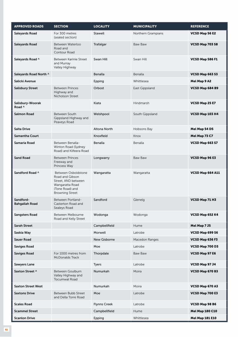
61
APPROVED ROADS SECTION LOCALITY MUNICIPALITY REFERENCE
Saleyards Road For 300 metres (sealed section)
Stawell Northern Grampians VCSD Map 56 E2
Saleyards Road Between Waterloo Road and Contour Road
Trafalgar Baw Baw VCSD Map 703 S8
Saleyards Road ^ Between Karinie Street and Murray Valley Highway
Swan Hill Swan Hill VCSD Map 586 F1
Saleyards Road North ^ Benalla Benalla VCSD Map 663 S3
Salicki Avenue Epping Whittlesea Mel Map 9 A2
Salisbury Street Between Princes Highway and Nicholson Street
Orbost East Gippsland VCSD Map 684 B9
Salisbury-Woorak Road ^
Kiata Hindmarsh VCSD Map 25 E7
Salmon Road Between South Gippsland Highway and Peaveys Road
Welshpool South Gippsland VCSD Map 103 H4
Salta Drive Altona North Hobsons Bay Mel Map 54 D5
Samantha Court Knoxfield Knox Mel Map 73 C7
Samaria Road Between Benalla-Winton Road (Sydney Road) and Kilfeera Road
Benalla Benalla VCSD Map 663 S7
Sand Road Between Princes Freeway and Princess Way
Longwarry Baw Baw VCSD Map 96 E3
Sandford Road ^ Between Osboldstone Road and Gibson Street, AND between Wangaratta Road (Tone Road) and Browning Street
Wangaratta Wangaratta VCSD Map 664 A11
Sandford- Bahgallah Road
Between Portland-Casterton Road and Sealeys Road
Sandford Glenelg VCSD Map 71 H3
Sangsters Road Between Melbourne Road and Kelly Street
Wodonga Wodonga VCSD Map 652 K4
Sarah Street Campbellfield Hume Mel Map 7 J5
Saskia Way Morwell Latrobe VCSD Map 699 S6
Sauer Road New Gisborne Macedon Ranges VCSD Map 636 F3
Saviges Road Moe Latrobe VCSD Map 700 D3
Saviges Road For 1000 metres from McDonalds Track
Thorpdale Baw Baw VCSD Map 97 E6
Sawyers Lane Tyers Latrobe VCSD Map 97 J4
Saxton Street ^ Between Goulburn Valley Highway and Tocumwal Road
Numurkah Moira VCSD Map 670 B3
Saxton Street West Numurkah Moira VCSD Map 670 A3
Saxtons Drive Between Bubb Street and Della Torre Road
Moe Latrobe VCSD Map 700 E3
Scales Road Flynns Creek Latrobe VCSD Map 98 B6
Scammel Street Campbellfield Hume Mel Map 180 C10
Scanlon Drive Epping Whittlesea Mel Map 181 E10

62
APPROVED ROADS SECTION LOCALITY MUNICIPALITY REFERENCE
Scarne Road Glengarry Latrobe VCSD Map 98 A4
Schembri Estate New roads in Schembri Estate
Derrimut Brimbank Mel Map 39 C4
Scholar Drive Between North of Enterprise Drive and South of Enterprise Drive
Bundoora Whittlesea Mel Map 10 B9
School Loop Road Landsborough West Northern Grampians VCSD Map 42 B10
School Road Between Darts Road and Westlakes Road
Portland North Glenelg VCSD Map 500 K9
Scollary Road Between Rinaldi Road and shire boundary
Logan Northern Grampians VCSD Map 42 J4
Scott Street Between McMeekin Road and Strong Street
Warrnambool Warrnambool VCSD Map 514 F6
Scott Street West Wodonga Wodonga VCSD Map 652 D2
Scott Street (Bonang Road)
Between Livingstone Street and Forest Road
Orbost East Gippsland VCSD Map 684 B7
Scrubby Lane Between Old Melbourne Road and Traralgon West Road
Traralgon Latrobe VCSD Map 97 J5
Sea Breeze Parade Between The Esplanade and Seabeach Parade
North Shore Greater Geelong Mel Map 442 D2
Seaside Parade Between Larneuk Street and Walchs Road
North Shore Greater Geelong Mel Map 442 D1
Seaview Parade Williamstown Hobsons Bay Mel Map 55 C7
Seismic Court Rowville Knox Mel Map 73 A10
Service Road Between Francis Briggs Road and Grants Road
Melbourne Airport Melbourne Airport Mel Map 5 B6
Service Street Echuca Campaspe VCSD Map 596 J9
Sette Circuit Pakenham Cardinia Mel Map 323 G1
Seven Mile Road (Koo Wee Rup-Nar Nar Goon Road)
Nar Nar Goon Cardinia Mel Map 319 D12
Seymour Street Between Breed Street and Princes Highway (Princes Street)
Traralgon Latrobe VCSD Map 696 G6
Seymour-Avenel Road Between Lambing Gully Road and the Shire boundary
Avenel Strathbogie VCSD Map 46 E8
Shakespeare Street Between Highland Highway and McNairn Road
Traralgon Latrobe VCSD Map 697 L7
Sharnet Circuit Pakenham Cardinia Mel Map 317 K10
Shanley Street ^ Between Wangaratta Road (Tone Road) and Reith Road
Wangaratta Wangaratta VCSD Map 664 A12
Sharps Road Service Road (North)
Between Keilor Park Drive and Airport Drive
Melbourne Airport Melbourne Airport Mel Map 15 E3
Sheathers Road Between Moloney Drive and Edwards Road
West Wodonga Wodonga VCSD Map 652 G2
Shelford- Mt. Mercer Road
Mt. Mercer Golden Plains VCSD Map 76 G8

63
APPROVED ROADS SECTION LOCALITY MUNICIPALITY REFERENCE
Shell Road Between Grubb Road and Sunset Strip Roundabout
Ocean Grove Greater Geelong Mel Map 484 C9
Shepherd Road Swan Hill Swan Hill VCSD Map 586 D1
Sherwood Court Wantirna South Knox Mel Map 64 B11
Shirley Way Epping Whittlesea Mel Map 181 E10
Short Street St Arnaud Northern Grampians VCSD Map 551 R8
Short Street Traralgon Latrobe VCSD Map 696 H7
Siddons Way Hallam Casey Mel Map 96 C2
Silver Birch Avenue Between Conifer Crescent and Garden Boulevard
Dingley Village Kingston Mel Map 88 A5
Simcock Avenue Spotswood Hobsons Bay Mel Map 42 A12
Simmie Street For 700 metres southwest of Elmore-Raywood Road to access Grain Corp
Elmore Greater Bendigo VCSD Map 627 M4
Sims Street West Melbourne Melbourne Mel Map 42 F5
Sinclair Drive Wangaratta Wangaratta VCSD Map 664 B10
Sisely Avenue ^ (Be aware of “stacking space” between rail crossing and Tone Road traffic signals
Wangaratta Wangaratta VCSD Map 664 D9
Sisters-Noorat Road Between Mortlake-Framlingham Road and Tapps Lane
The Sisters Moyne VCSD Map 90 F5
Sky Road Melbourne Airport Hume Mel Map 5 A12
Slaughteryard Creek Road
Between Merriang South Road and the pine plantation
Merriang South Alpine VCSD Map 49 C3
Sleepy Lane Kerang Gannawarra VCSD Map 20 H6
Slevin Street Between Victoria Street and property No. 28 (transport depot)
North Geelong Greater Geelong Mel Map 441 K9
Slough Road Altona Hobsons Bay Mel Map 54 B8
Smeaton Street Stawell Northern Grampians VCSD Map 550 C6
Smith Road Between Princes Highway and McWilliam Street
Springvale Greater Dandenong Mel Map 80 D6
Smith Street Between Playford Street and Griffiths Street
Stawell Northern Grampians VCSD Map 550 B7
Smythe Street Shepparton Greater Shepparton VCSD Map 673 R10
Soldiers Road Fish Creek South Gippsland VCSD Map 103 B6
Soldiers Road Between Bass Highway and Gwyther Siding Road
Leongatha South South Gippsland VCSD Map 102 H2
Somerleigh Road Laverton North Wyndham Mel Map 40 D9
Somerton Park Drive Campbellfield Hume Mel Map 180 D10
Somerton Park Road Between Raglan Street and Cobains Road
Sale Wellington VCSD Map 693 U4
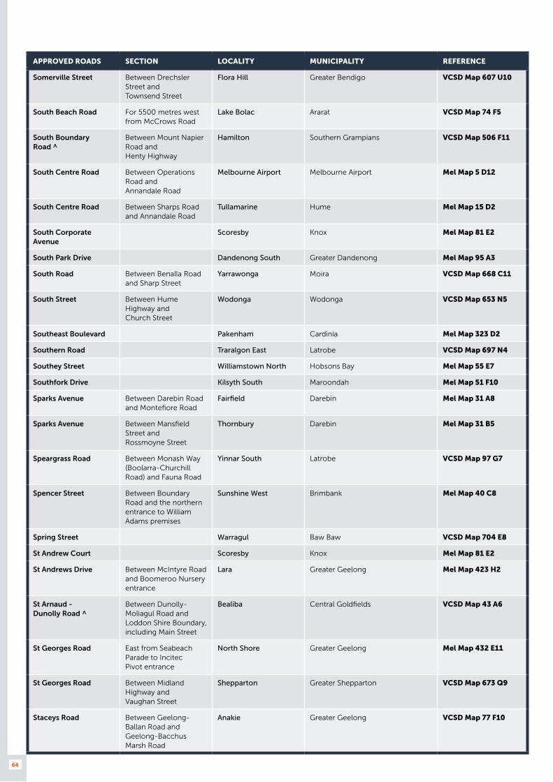
64
APPROVED ROADS SECTION LOCALITY MUNICIPALITY REFERENCE
Somerville Street Between Drechsler Street and Townsend Street
Flora Hill Greater Bendigo VCSD Map 607 U10
South Beach Road For 5500 metres west from McCrows Road
Lake Bolac Ararat VCSD Map 74 F5
South Boundary Road ^
Between Mount Napier Road and Henty Highway
Hamilton Southern Grampians VCSD Map 506 F11
South Centre Road Between Operations Road and Annandale Road
Melbourne Airport Melbourne Airport Mel Map 5 D12
South Centre Road Between Sharps Road and Annandale Road
Tullamarine Hume Mel Map 15 D2
South Corporate Avenue
Scoresby Knox Mel Map 81 E2
South Park Drive Dandenong South Greater Dandenong Mel Map 95 A3
South Road Between Benalla Road and Sharp Street
Yarrawonga Moira VCSD Map 668 C11
South Street Between Hume Highway and Church Street
Wodonga Wodonga VCSD Map 653 N5
Southeast Boulevard Pakenham Cardinia Mel Map 323 D2
Southern Road Traralgon East Latrobe VCSD Map 697 N4
Southey Street Williamstown North Hobsons Bay Mel Map 55 E7
Southfork Drive Kilsyth South Maroondah Mel Map 51 F10
Sparks Avenue Between Darebin Road and Montefiore Road
Fairfield Darebin Mel Map 31 A8
Sparks Avenue Between Mansfield Street and Rossmoyne Street
Thornbury Darebin Mel Map 31 B5
Speargrass Road Between Monash Way (Boolarra-Churchill Road) and Fauna Road
Yinnar South Latrobe VCSD Map 97 G7
Spencer Street Between Boundary Road and the northern entrance to William Adams premises
Sunshine West Brimbank Mel Map 40 C8
Spring Street Warragul Baw Baw VCSD Map 704 E8
St Andrew Court Scoresby Knox Mel Map 81 E2
St Andrews Drive Between McIntyre Road and Boomeroo Nursery entrance
Lara Greater Geelong Mel Map 423 H2
St Arnaud - Dunolly Road ^
Between Dunolly-Moliagul Road and Loddon Shire Boundary, including Main Street
Bealiba Central Goldfields VCSD Map 43 A6
St Georges Road East from Seabeach Parade to Incitec Pivot entrance
North Shore Greater Geelong Mel Map 432 E11
St Georges Road Between Midland Highway and Vaughan Street
Shepparton Greater Shepparton VCSD Map 673 Q9
Staceys Road Between Geelong-Ballan Road and Geelong-Bacchus Marsh Road
Anakie Greater Geelong VCSD Map 77 F10

65
APPROVED ROADS SECTION LOCALITY MUNICIPALITY REFERENCE
Standing Drive Traralgon East Latrobe VCSD Map 697 N5
Stanhope Street Between Barnawartha-Howling Road and High Street
Barnawartha Indigo VCSD Map 658 H9
Stanley Drive Somerton Hume Mel Map 180 C5
Stanley Road Laverton North Wyndham Mel Map 40 B10
Star Crescent Hallam Casey Mel Map 96 F3
Station Street Between Goulburn Valley Highway and William Street
Alexandra Murrindindi VCSD Map 680 F2
Station Street Maffra Wellington VCSD Map 694 C7
Station Street Numurkah Moira VCSD Map 670 B6
Station Street Officer Cardinia Mel Map 215 H5
Station Street Between Woorinen Road and Woorinen-Vinifera Road
Woorinen Swan Hill VCSD Map 13 J6
Station Street ^ Between Murray Valley Highway and Lalbert Road (including road known also as Kunat Street but excluding north west section of Station Street from T- intersection)
Lake Boga Swan Hill VCSD Map 588 H2
Stead Street West Wodonga Wodonga VCSD Map 652 D3
Steane Street Between Sparks Avenue and Grange Road
Fairfield Darebin Mel Map 31 A7
Stephenson Road Bayswater North Maroondah Mel Map 51 D9
Stephenson Road Seaford Frankston Mel Map 99 K2
Sternberg Street Between Townsend Street and McIvor Highway
Kennington Greater Bendigo VCSD Map 607 U6
Stewart and Dunlops Road
From Tarwin Lower Road up to Dunlops Bridge (Tarwin River)
Middle Tarwin South Gippsland VCSD Map 102 H5
Stewarts Road Kongwak South Gippsland VCSD Map 102 E2
Stock Route Between Briggs Gap Road and Thomas Lane
Corryong Towong VCSD Map 644 B3
Stock Route Road Korumburra South South Gippsland VCSD Map 96 F9
Stockdale Road Briagolong Wellington VCSD Map 83 C8
Stockdales Road For 1000 metres from Morwell-Thorpdale Road
Thorpdale Baw Baw VCSD Map 97 E6
Stonepark Road ^ Delacombe Ballarat VCSD Map 565 Q10
Stoney Way Derrimut Brimbank Mel Map 39 A5
Strathlea Road ^ Newstead Mount Alexander VCSD Map 627
Stratton Drive Traralgon East Latrobe VCSD Map 697 N4
Strezlecki Avenue Sunshine West Brimbank Mel Map 40 F6
Strickland Road Between Powells Avenue and Pratts Park Road
East Bendigo Greater Bendigo VCSD Map 608 E4
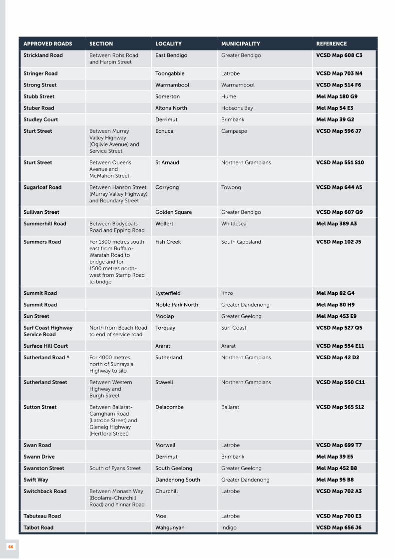
66
APPROVED ROADS SECTION LOCALITY MUNICIPALITY REFERENCE
Strickland Road Between Rohs Road and Harpin Street
East Bendigo Greater Bendigo VCSD Map 608 C3
Stringer Road Toongabbie Latrobe VCSD Map 703 N4
Strong Street Warrnambool Warrnambool VCSD Map 514 F6
Stubb Street Somerton Hume Mel Map 180 G9
Stuber Road Altona North Hobsons Bay Mel Map 54 E3
Studley Court Derrimut Brimbank Mel Map 39 G2
Sturt Street Between Murray Valley Highway (Ogilvie Avenue) and Service Street
Echuca Campaspe VCSD Map 596 J7
Sturt Street Between Queens Avenue and McMahon Street
St Arnaud Northern Grampians VCSD Map 551 S10
Sugarloaf Road Between Hanson Street (Murray Valley Highway) and Boundary Street
Corryong Towong VCSD Map 644 A5
Sullivan Street Golden Square Greater Bendigo VCSD Map 607 Q9
Summerhill Road Between Bodycoats Road and Epping Road
Wollert Whittlesea Mel Map 389 A3
Summers Road For 1300 metres south-east from Buffalo-Waratah Road to bridge and for 1500 metres north-west from Stamp Road to bridge
Fish Creek South Gippsland VCSD Map 102 J5
Summit Road Lysterfield Knox Mel Map 82 G4
Summit Road Noble Park North Greater Dandenong Mel Map 80 H9
Sun Street Moolap Greater Geelong Mel Map 453 E9
Surf Coast Highway Service Road
North from Beach Road to end of service road
Torquay Surf Coast VCSD Map 527 Q5
Surface Hill Court Ararat Ararat VCSD Map 554 E11
Sutherland Road ^ For 4000 metres north of Sunraysia Highway to silo
Sutherland Northern Grampians VCSD Map 42 D2
Sutherland Street Between Western Highway and Burgh Street
Stawell Northern Grampians VCSD Map 550 C11
Sutton Street Between Ballarat-Carngham Road (Latrobe Street) and Glenelg Highway (Hertford Street)
Delacombe Ballarat VCSD Map 565 S12
Swan Road Morwell Latrobe VCSD Map 699 T7
Swann Drive Derrimut Brimbank Mel Map 39 E5
Swanston Street South of Fyans Street South Geelong Greater Geelong Mel Map 452 B8
Swift Way Dandenong South Greater Dandenong Mel Map 95 B8
Switchback Road Between Monash Way (Boolarra-Churchill Road) and Yinnar Road
Churchill Latrobe VCSD Map 702 A3
Tabuteau Road Moe Latrobe VCSD Map 700 E3
Talbot Road Wahgunyah Indigo VCSD Map 656 J6

67
APPROVED ROADS SECTION LOCALITY MUNICIPALITY REFERENCE
Tampe Road Rowville Knox Mel Map 72 K9
Taras Avenue Altona North Hobsons Bay Mel Map 54 E5
Tarcombe Road Between High Street and Oak Street
Seymour Mitchell VCSD Map 642 E5
Tarcombe Road Between Hume Freeway and Upton Road
Avenel Strathbogie VCSD Map 677 U6
Tarkin Court Bell Park Greater Geelong Mel Map 441 H2
Tarnagulla Road Inglewood Loddon VCSD Map 43 F5
Tarnard Drive Between Boundary Road and Bell Grove
Braeside Kingston Mel Map 87 K8
Taryn Drive Epping Whittlesea Mel Map 181 F10
Tatterson Road Dandenong South Greater Dandenong Mel Map 95 C2
Tatyoon North Road Between Helendoite Road and Mount William Road
Tatyoon Ararat VCSD Map 56 H9
Tatyoon Road ^ Langi Logan Ararat VCSD Map 74 H2
Taylors Road Between Colemans Road and Abbotts Road
Dandenong South Greater Dandenong Mel Map 95 G10
Technical Drive Craigieburn Hume Mel Map 180 D1
Technology Circuit Hallam Casey Mel Map 96 D2
Technology Drive Sunshine West Brimbank Mel Map 40 F8
Telford Road Glenorchy Northern Grampians VCSD Map 41 C8
Temple Drive Thomastown Whittlesea Mel Map 8 K10
Tennyson Street Between Salisbury Street and Lochiel Street (Bonang Road)
Orbost East Gippsland VCSD Map 684 B10
Tennyson Street Williamstown North Hobsons Bay Mel Map 55 E7
Terang- Framlingham Road
Between Ellerslie-Panmure Road and Wintons Lane
Framlingham Moyne VCSD Map 90 D5
The Centreway North Geelong Greater Geelong Mel Map 442 A3
The Crossway Campbellfield Hume Mel Map 180 C12
The Esplanade Between Madden Avenue and Seabreeze Parade
North Shore Greater Geelong Mel Map 432 G12
The Gateway Altona North Hobsons Bay Mel Map 54 G3
Thistle Street Between Adam Street and 150 metres north of Sullivan Street
Golden Square Greater Bendigo VCSD Map 607 Q9
Thomas Lane Between Stock Route and Hanson Street (Murray Valley Highway)
Corryong Towong VCSD Map 37 G4
Thomas Road Laverton North Wyndham Mel Map 40 B10
Thomas Murrell Crescent
Dandenong South Greater Dandenong Mel Map 94 K5
Thomas Street Ferntree Gully Knox Mel Map 73 K4
Thompson Street ^ Between Broadway (Maryborough-Dunolly Road) and Separation Road
Dunolly Central Goldfields VCSD Map 559 S4
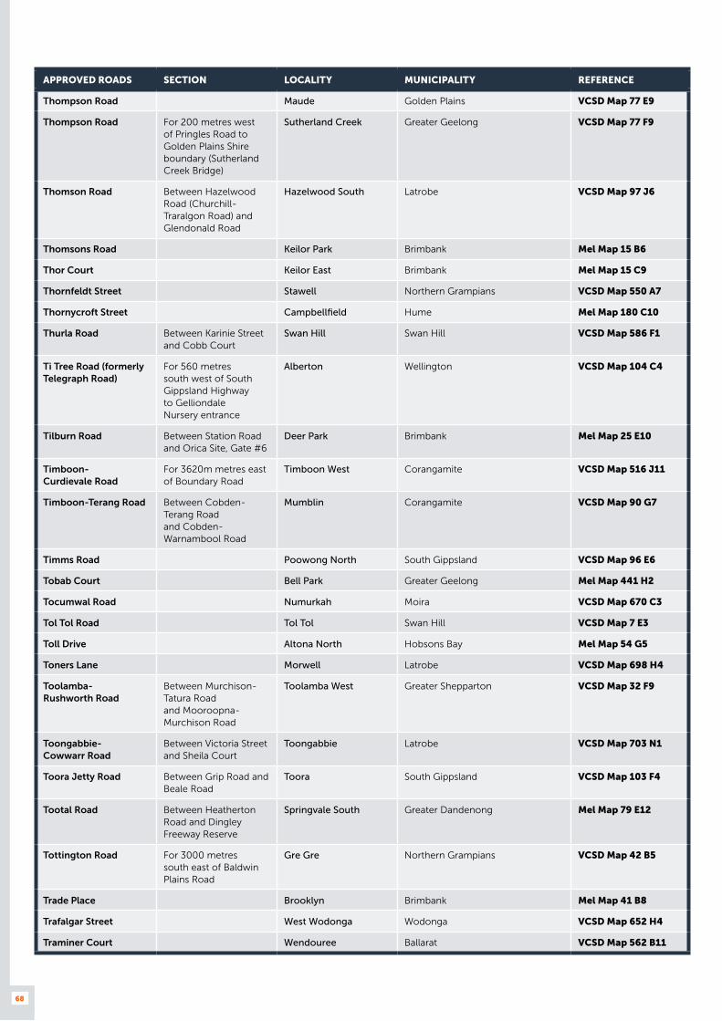
68
APPROVED ROADS SECTION LOCALITY MUNICIPALITY REFERENCE
Thompson Road Maude Golden Plains VCSD Map 77 E9
Thompson Road For 200 metres west of Pringles Road to Golden Plains Shire boundary (Sutherland Creek Bridge)
Sutherland Creek Greater Geelong VCSD Map 77 F9
Thomson Road Between Hazelwood Road (Churchill-Traralgon Road) and Glendonald Road
Hazelwood South Latrobe VCSD Map 97 J6
Thomsons Road Keilor Park Brimbank Mel Map 15 B6
Thor Court Keilor East Brimbank Mel Map 15 C9
Thornfeldt Street Stawell Northern Grampians VCSD Map 550 A7
Thornycroft Street Campbellfield Hume Mel Map 180 C10
Thurla Road Between Karinie Street and Cobb Court
Swan Hill Swan Hill VCSD Map 586 F1
Ti Tree Road (formerly Telegraph Road)
For 560 metres south west of South Gippsland Highway to Gelliondale Nursery entrance
Alberton Wellington VCSD Map 104 C4
Tilburn Road Between Station Road and Orica Site, Gate #6
Deer Park Brimbank Mel Map 25 E10
Timboon- Curdievale Road
For 3620m metres east of Boundary Road
Timboon West Corangamite VCSD Map 516 J11
Timboon-Terang Road Between Cobden-Terang Road and Cobden-Warnambool Road
Mumblin Corangamite VCSD Map 90 G7
Timms Road Poowong North South Gippsland VCSD Map 96 E6
Tobab Court Bell Park Greater Geelong Mel Map 441 H2
Tocumwal Road Numurkah Moira VCSD Map 670 C3
Tol Tol Road Tol Tol Swan Hill VCSD Map 7 E3
Toll Drive Altona North Hobsons Bay Mel Map 54 G5
Toners Lane Morwell Latrobe VCSD Map 698 H4
Toolamba- Rushworth Road
Between Murchison-Tatura Road and Mooroopna-Murchison Road
Toolamba West Greater Shepparton VCSD Map 32 F9
Toongabbie- Cowwarr Road
Between Victoria Street and Sheila Court
Toongabbie Latrobe VCSD Map 703 N1
Toora Jetty Road Between Grip Road and Beale Road
Toora South Gippsland VCSD Map 103 F4
Tootal Road Between Heatherton Road and Dingley Freeway Reserve
Springvale South Greater Dandenong Mel Map 79 E12
Tottington Road For 3000 metres south east of Baldwin Plains Road
Gre Gre Northern Grampians VCSD Map 42 B5
Trade Place Brooklyn Brimbank Mel Map 41 B8
Trafalgar Street West Wodonga Wodonga VCSD Map 652 H4
Traminer Court Wendouree Ballarat VCSD Map 562 B11
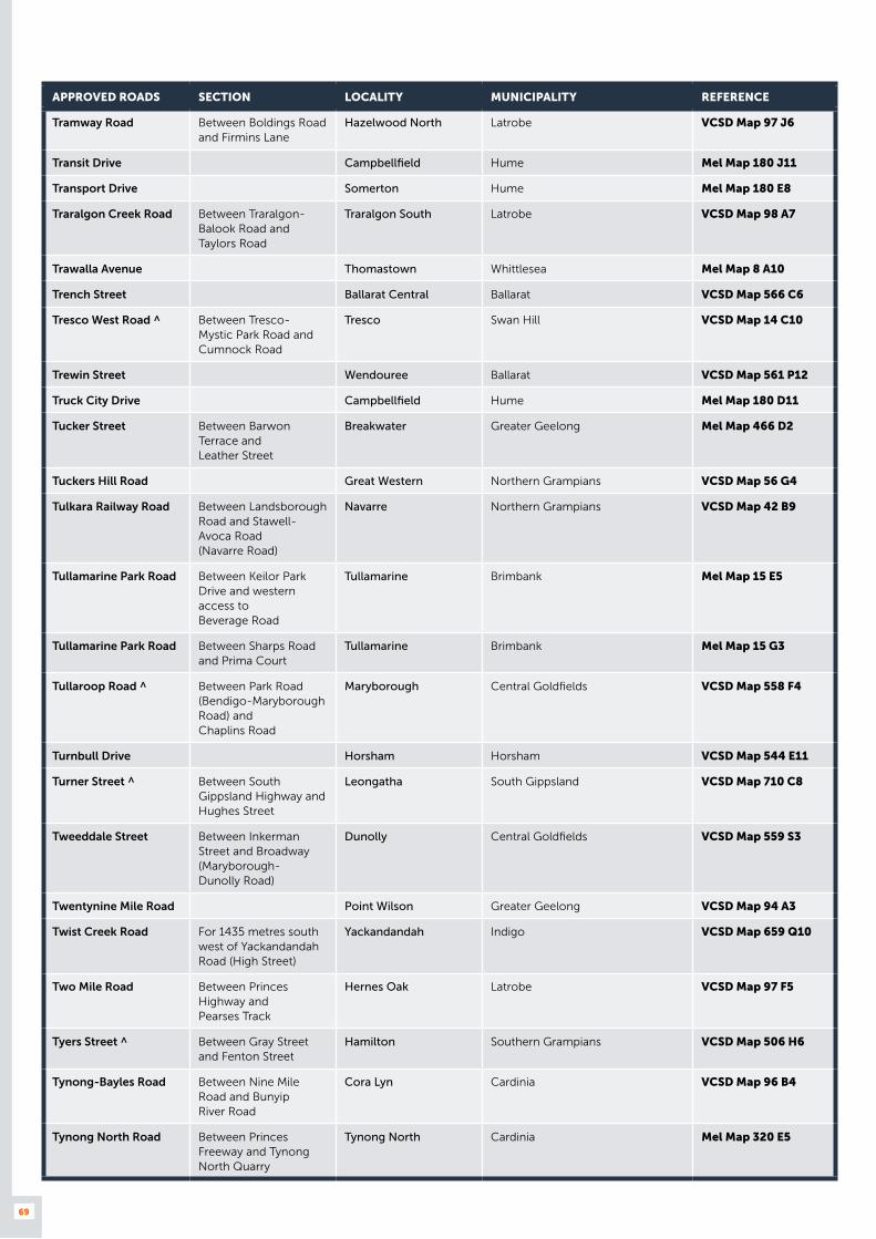
69
APPROVED ROADS SECTION LOCALITY MUNICIPALITY REFERENCE
Tramway Road Between Boldings Road and Firmins Lane
Hazelwood North Latrobe VCSD Map 97 J6
Transit Drive Campbellfield Hume Mel Map 180 J11
Transport Drive Somerton Hume Mel Map 180 E8
Traralgon Creek Road Between Traralgon-Balook Road and Taylors Road
Traralgon South Latrobe VCSD Map 98 A7
Trawalla Avenue Thomastown Whittlesea Mel Map 8 A10
Trench Street Ballarat Central Ballarat VCSD Map 566 C6
Tresco West Road ^ Between Tresco-Mystic Park Road and Cumnock Road
Tresco Swan Hill VCSD Map 14 C10
Trewin Street Wendouree Ballarat VCSD Map 561 P12
Truck City Drive Campbellfield Hume Mel Map 180 D11
Tucker Street Between Barwon Terrace and Leather Street
Breakwater Greater Geelong Mel Map 466 D2
Tuckers Hill Road Great Western Northern Grampians VCSD Map 56 G4
Tulkara Railway Road Between Landsborough Road and Stawell-Avoca Road (Navarre Road)
Navarre Northern Grampians VCSD Map 42 B9
Tullamarine Park Road Between Keilor Park Drive and western access to Beverage Road
Tullamarine Brimbank Mel Map 15 E5
Tullamarine Park Road Between Sharps Road and Prima Court
Tullamarine Brimbank Mel Map 15 G3
Tullaroop Road ^ Between Park Road (Bendigo-Maryborough Road) and Chaplins Road
Maryborough Central Goldfields VCSD Map 558 F4
Turnbull Drive Horsham Horsham VCSD Map 544 E11
Turner Street ^ Between South Gippsland Highway and Hughes Street
Leongatha South Gippsland VCSD Map 710 C8
Tweeddale Street Between Inkerman Street and Broadway (Maryborough- Dunolly Road)
Dunolly Central Goldfields VCSD Map 559 S3
Twentynine Mile Road Point Wilson Greater Geelong VCSD Map 94 A3
Twist Creek Road For 1435 metres south west of Yackandandah Road (High Street)
Yackandandah Indigo VCSD Map 659 Q10
Two Mile Road Between Princes Highway and Pearses Track
Hernes Oak Latrobe VCSD Map 97 F5
Tyers Street ^ Between Gray Street and Fenton Street
Hamilton Southern Grampians VCSD Map 506 H6
Tynong-Bayles Road Between Nine Mile Road and Bunyip River Road
Cora Lyn Cardinia VCSD Map 96 B4
Tynong North Road Between Princes Freeway and Tynong North Quarry
Tynong North Cardinia Mel Map 320 E5
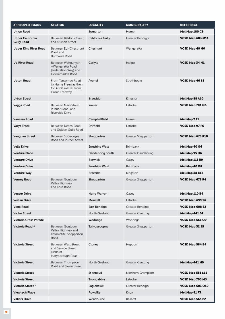
70
APPROVED ROADS SECTION LOCALITY MUNICIPALITY REFERENCE
Union Road Somerton Hume Mel Map 180 C9
Upper California Gully Road
Between Baldock Court and Sturton Street
California Gully Greater Bendigo VCSD Map 603 M11
Upper King River Road Between Edi-Chesthunt Road and Burrowes Road
Cheshunt Wangaratta VCSD Map 48 H6
Up River Road Between Wahgunyah –Wangaratta Road (Federation Way) and Gooramadda Road
Carlyle Indigo VCSD Map 34 H1
Upton Road From Tarcombe Road to Hume Freeway then for 4000 metres from Hume Freeway
Avenel Strathbogie VCSD Map 46 E8
Urban Street Braeside Kingston Mel Map 88 A10
Vaggs Road Between Main Street (Yinnar Road) and Riverside Drive
Yinnar Latrobe VCSD Map 701 Q6
Vanessa Road Campbellfield Hume Mel Map 7 F1
Varys Track Between Deans Road and Golden Gully Road
Driffield Latrobe VCSD Map 97 F6
Vaughan Street Between St Georges Road and Purcell Street
Shepparton Greater Shepparton VCSD Map 673 R10
Vella Drive Sunshine West Brimbank Mel Map 40 G6
Ventura Place Dandenong South Greater Dandenong Mel Map 95 H6
Venture Drive Berwick Casey Mel Map 111 B9
Venture Drive Sunshine West Brimbank Mel Map 40 G8
Venture Way Braeside Kingston Mel Map 88 B12
Verney Road Between Goulburn Valley Highway and Ford Road
Shepparton Greater Shepparton VCSD Map 673 R4
Vesper Drive Narre Warren Casey Mel Map 110 B4
Vestan Drive Morwell Latrobe VCSD Map 699 S6
Victa Road East Bendigo Greater Bendigo VCSD Map 608 E2
Victor Street North Geelong Greater Geelong Mel Map 441 J4
Victoria Cross Parade Wodonga Wodonga VCSD Map 653 O9
Victoria Road ^ Between Goulburn Valley Highway and Katamatite-Shepparton Road
Tallygaroopna Greater Shepparton VCSD Map 32 J5
Victoria Street Between West Street and Service Street (Ballarat- Maryborough Road)
Clunes Hepburn VCSD Map 584 B4
Victoria Street Between Thompson Road and Slevin Street
North Geelong Greater Geelong Mel Map 441 H9
Victoria Street St Arnaud Northern Grampians VCSD Map 551 S11
Victoria Street Toongabbie Latrobe VCSD Map 703 M3
Victoria Street ^ Eaglehawk Greater Bendigo VCSD Map 603 O10
Viewtech Place Rowville Knox Mel Map 81 F3
Villiers Drive Wendouree Ballarat VCSD Map 565 P2

71
APPROVED ROADS SECTION LOCALITY MUNICIPALITY REFERENCE
Vincent Road Between Greta Road and Tone Road
Wangaratta Wangaratta VCSD Map 664 D10
Wadhurst Drive Boronia Knox Mel Map 64 C10
Waites Road Glengarry West Latrobe VCSD Map 98 A4
Walchs Road Between The Esplanade and Coonil Crescent
North Shore Greater Geelong Mel Map 442 D1
Walker Street Anglesea Surf Coast VCSD Map 526 E3
Walker Street Braeside Kingston Mel Map 87 K10
Walker Street ^ Castlemaine Mount Alexander VCSD Map 628 F4
Wallaloo East Road Wallaloo East Northern Grampians VCSD Map 41 G7
Wallenjoe Road Between Leans Road and Bendigo Livestock Exchange
Huntly Greater Bendigo VCSD Map 600 B12
Wallis Street Between Martin Drive and Whitelaw Avenue
Delacombe Ballarat VCSD Map 565 R10
Wallis Street Between Goulburn Valley Highway and High Street
Seymour Mitchell VCSD Map 642 C5
Wallis Street ^ Between Ballarat-Carngham Road (Latrobe Street) and Martin Drive
Delacombe Ballarat VCSD Map 565 R11
Walpole Parade Between St Georges Road and Nelson Street
Norlane Greater Geelong Mel Map 432 D11
Walsh Road ^ Warrnambool Warrnambool VCSD Map 514 F4
Walshs Road Between Hazelwood Estate Road and Monash Way (Boolarra-Churchill Road)
Hazelwood Latrobe VCSD Map 97 G7
Wangandary Road Between Wangaratta-Yarrawonga Road and Christensens Lane
Wangaratta Wangaratta VCSD Map 664 A4
Wanganui Road Shepparton Greater Shepparton VCSD Map 673 L2
Wangaratta- Eldorado Road
North Wangaratta Wangaratta VCSD Map 34 H7
Wangaratta- Kilfeera Road
Between Glenrowan-Myrtleford Road and shire boundary
Greta Wangaratta VCSD Map 34 F9
Warby Range Road Between Old Hume Highway and Lindner Road
Glenrowan Wangaratta VCSD Map 666 J8
Warby Street Between Ovens Street and Ryley Street
Wangaratta Wangaratta VCSD Map 664 G8
Waringa Drive Mitchell Park Ballarat VCSD Map 561 P9
Warracknabeal-Antwerp Road
Between Dimboola-Rainbow Road and Yarriambiack Shire boundary
Katyil Hindmarsh VCSD Map 26 C6
Warraquil Road Baker Hindmarsh VCSD Map 25 B3
Warrowie Road Between Princes Highway and railway line
Colac Colac Otway VCSD Map 92 C6
Waterloo Road Between Saviges Road and Latrobe City boundary
Moe Latrobe VCSD Map 700 A6

72
APPROVED ROADS SECTION LOCALITY MUNICIPALITY REFERENCE
Waterloo Road Between Saleyards Road and Willowgrove Road
Trafalgar Baw Baw VCSD Map 703 S9
Waterloo Road (level crossing) ^
NORTH BOUND ONLY Moe Latrobe VCSD Map 700 D5
Waterview Close Dandenong South Greater Dandenong Mel Map 95 K4
Watson Road Leongatha South Gippsland VCSD Map 710 E7
Watson Road Lorquon Hindmarsh VCSD Map 24 E4
Watson Street Between Braithwaite Street and Granter Street
Warrnambool Warrnambool VCSD Map 514 E5
Watson Street For 70 metres north of Elgin Boulevard (Melbourne Road South)
Wodonga Wodonga VCSD Map 653 M6
Watsons Road Between Mountain Glen Drive and Tambo Road
Moe Latrobe VCSD Map 700 A9
Wattlepark Avenue Moolap Greater Geelong Mel Map 453 C9
Wawunna Road Between Mill Street and Lynott Street
Horsham Horsham VCSD Map 544 E4
Webb Dock Access Road 2
For 270 metres south west of Dockside Road
West Melbourne Port of Melbourne Corporation Mel Map 56 F3
Webb Dock Access Road 3
For 154 metres south west of Dockside Road
West Melbourne Port of Melbourne Corporation Mel Map 56 F3
Webster Drive Swan Hill Swan Hill VCSD Map 586 D1
Webster Street Churchill Latrobe VCSD Map 702 B3
Webster Street ^ Dandenong Greater Dandenong Mel Map 90 C9
Weddell Road North Geelong Greater Geelong Mel Map 441 J11
Wedge Street Hamilton Southern Grampians VCSD Map 506 C10
Wedgewood Road Hallam Casey Mel Map 96 D3
Weerong Road Drouin Baw Baw VCSD Map 96 F3
Weeroona Avenue ^ Bendigo Greater Bendigo VCSD Map 607 U3
Wegner Street Morwell Latrobe VCSD Map 699 L5
Weir Road Between Traralgon-Maffra Road and north intersection of Justice Parade
Heyfield Wellington VCSD Map 695 Q10
Wellsford Drive East Bendigo Greater Bendigo VCSD Map 608 E3
West Court Derrimut Brimbank Mel Map 360 K7
West Park Drive Derrimut Brimbank Mel Map 39 C7
West Street Between Victoria Street and Talbot Road (Ballarat-Maryborough Road)
Clunes Hepburn VCSD Map 584 B4
Western Highway Service Road
North of Western Highway from Saleyards Road (730 metres west to lot 41)
Stawell Northern Grampians VCSD Map 550 A7

73
APPROVED ROADS SECTION LOCALITY MUNICIPALITY REFERENCE
Western Highway Service Road
South of Western Highway between lots 42 and 54 (between Holloway Central Road and Gilchrist Road)
Stawell Northern Grampians VCSD Map 550 E11
Western Road For 500 metres northwest from Cohuna-Leitchville Road
Cohuna Gannawarra VCSD Map 590 G11
Westgate Drive Altona North Hobsons Bay Mel Map 54 E1
Westlink Court Altona Hobsons Bay Mel Map 53 H7
Westpool Drive Hallam Casey Mel Map 96 E3
Westwood Drive ^ Between Western Highway and Robinsons Road
Ravenhall Melton Mel Map 25 A8
Whatton Place Between Miller Street and Goulburn Valley Highway (Downey Street)
Yea Murrindindi VCSD Map 681 T9
Wheeldon Court Traralgon Latrobe VCSD Map 697 M5
Wheeler Street ^ Shepparton Greater Shepparton VCSD Map 673 S8
Whip Court Long Gully Greater Bendigo VCSD Map 607 P2
White Post Road Everton Wangaratta VCSD Map 35 A8
White Rock Road Warrnambool Warrnambool VCSD Map 514 E4
Whitehead Avenue Nhill Hindmarsh VCSD Map 546 E2
Whitelaw Avenue Delacombe Ballarat VCSD Map 565 Q12
Whitelaws Track Between Callignee South Road and Scales Road
Callignee Latrobe VCSD Map 98 B6
Whitelaws Track Leongatha South South Gippsland VCSD Map 102 H2
Whitelaws Track Between Monash Way (Boolarra-Churchill Road) and Fauna Road
Yinnar South Latrobe VCSD Map 97 G7
Whiters Street Between Princes Highway East and Entrance Court
Lakes Entrance East Gippsland VCSD Map 686 J5
Whitty Lane Between Wangaratta-Whitfield Road and Koombahla Vineyard entrance
Whitfield Wangaratta VCSD Map 48 H6
Whorouly Road Whorouly Wangaratta VCSD Map 49 B2
Whorouly- Bowmans Road
Whorouly Wangaratta VCSD Map 49 B2
Whytes Road Between Murray Valley Highway and Baranduda Drive
Bandiana Wodonga VCSD Map 35 H4
Wigan Road Bayswater Knox Mel Map 64 J5
Wigg Street Between Osburn Street and Michael Drive
Wodonga Wodonga VCSD Map 653 P6
Wild Dog Valley Road For 4800 metres from Strzelecki Highway
Leongatha South Gippsland VCSD Map 710 D7
Wilhelmina Falls Road Murrindindi Murrindindi VCSD Map 62 A8
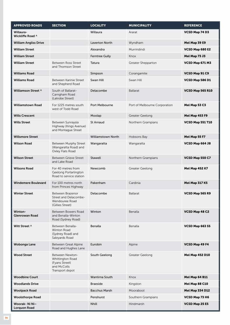
74
APPROVED ROADS SECTION LOCALITY MUNICIPALITY REFERENCE
Willaura- Wickliffe Road ^
Willaura Ararat VCSD Map 74 D3
William Angliss Drive Laverton North Wyndham Mel Map 39 E9
William Street Alexandra Murrindindi VCSD Map 680 E2
William Street Ferntree Gully Knox Mel Map 73 J3
William Street Between Ross Street and Thomson Street
Tatura Greater Shepparton VCSD Map 671 M3
Williams Road Simpson Corangamite VCSD Map 91 C9
Williams Road Between Karinie Street and Shepherd Road
Swan Hill Swan Hill VCSD Map 586 D1
Williamson Street ^ South of Ballarat-Carngham Road (Latrobe Street)
Delacombe Ballarat VCSD Map 565 R10
Williamstown Road For 1225 metres south west of Todd Road
Port Melbourne Port of Melbourne Corporation Mel Map 53 C3
Wills Crescent Moolap Greater Geelong Mel Map 453 F9
Wills Street Between Sunraysia Highway (Kings Avenue) and Montague Street
St Arnaud Northern Grampians VCSD Map 551 T10
Willsmore Street Williamstown North Hobsons Bay Mel Map 55 F7
Wilson Road Between Murphy Street (Wangaratta Road) and Oxley Flats Road
Wangaratta Wangaratta VCSD Map 664 J8
Wilson Street Between Grieve Street and Lake Road
Stawell Northern Grampians VCSD Map 550 C7
Wilsons Road For 40 metres from Geelong Portarlington Road to service station
Newcomb Greater Geelong Mel Map 452 K7
Windemere Boulevard For 100 metres north from Princes Highway
Pakenham Cardinia Mel Map 317 K5
Winter Street Between Brazenor Street and Delacombe-Wendouree Road (Gillies Street)
Delacombe Ballarat VCSD Map 565 R9
Winton- Glenrowan Road
Between Bowers Road and Benalla-Winton Road (Sydney Road)
Winton Benalla VCSD Map 48 C2
Witt Street ^ Between Benalla-Winton Road (Sydney Road) and Saleyards Road
Benalla Benalla VCSD Map 663 S5
Wobonga Lane Between Great Alpine Road and Hughes Lane
Eurobin Alpine VCSD Map 49 F4
Wood Street Between Newton-Whittington Road (Fyans Street) and McColls Transport depot
South Geelong Greater Geelong Mel Map 452 D10
Woodbine Court Wantirna South Knox Mel Map 64 B11
Woodlands Drive Braeside Kingston Mel Map 88 C10
Woolpack Road Bacchus Marsh Moorabool Mel Map 334 D12
Woolsthorpe Road Penshurst Southern Grampians VCSD Map 73 H6
Woorak- Ni Ni– Lorquon Road
Nhill Hindmarsh VCSD Map 25 E5
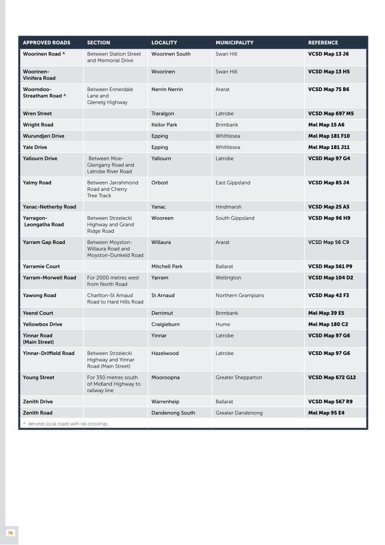
75
APPROVED ROADS SECTION LOCALITY MUNICIPALITY REFERENCE
Woorinen Road ^ Between Station Street and Memorial Drive
Woorinen South Swan Hill VCSD Map 13 J6
Woorinen- Vinifera Road
Woorinen Swan Hill VCSD Map 13 H5
Woorndoo- Streatham Road ^
Between Ennerdale Lane and Glenelg Highway
Nerrin Nerrin Ararat VCSD Map 75 B6
Wren Street Traralgon Latrobe VCSD Map 697 M5
Wright Road Keilor Park Brimbank Mel Map 15 A6
Wurundjeri Drive Epping Whittlesea Mel Map 181 F10
Yale Drive Epping Whittlesea Mel Map 181 J11
Yallourn Drive Between Moe-Glengarry Road and Latrobe River Road
Yallourn Latrobe VCSD Map 97 G4
Yalmy Road Between Jarrahmond Road and Cherry Tree Track
Orbost East Gippsland VCSD Map 85 J4
Yanac-Netherby Road Yanac Hindmarsh VCSD Map 25 A3
Yarragon- Leongatha Road
Between Strzelecki Highway and Grand Ridge Road
Wooreen South Gippsland VCSD Map 96 H9
Yarram Gap Road Between Moyston-Willaura Road and Moyston-Dunkeld Road
Willaura Ararat VCSD Map 56 C9
Yarramie Court Mitchell Park Ballarat VCSD Map 561 P9
Yarram-Morwell Road For 2000 metres west from North Road
Yarram Wellington VCSD Map 104 D2
Yawong Road Charlton-St Arnaud Road to Hard Hills Road
St Arnaud Northern Grampians VCSD Map 42 F3
Yeend Court Derrimut Brimbank Mel Map 39 E5
Yellowbox Drive Craigieburn Hume Mel Map 180 C2
Yinnar Road (Main Street)
Yinnar Latrobe VCSD Map 97 G6
Yinnar-Driffield Road Between Strzelecki Highway and Yinnar Road (Main Street)
Hazelwood Latrobe VCSD Map 97 G6
Young Street For 350 metres south of Midland Highway to railway line
Mooroopna Greater Shepparton VCSD Map 672 G12
Zenith Drive Warrenheip Ballarat VCSD Map 567 R9
Zenith Road Dandenong South Greater Dandenong Mel Map 95 E4
^ denotes local roads with rail crossings.