VICTORIA QUAY COMMERCIAL PRECINCT PLAN ... VICTORIA QUAY COMMERCIAL PRECINCT PLAN FINAL DRAFT 4.0...
8
VICTORIA QUAY COMMERCIAL PRECINCT PLAN AUGUST 2014
Transcript of VICTORIA QUAY COMMERCIAL PRECINCT PLAN ... VICTORIA QUAY COMMERCIAL PRECINCT PLAN FINAL DRAFT 4.0...
VICTORIA QUAY COMMERCIAL PRECINCT PLAN
AUGUST 2014

24
4.0Planning Context

25
VICTORIA QUAY COMMERCIAL PRECINCT PLAN
FIN
AL
DR
AF
T
4.0 PLANNING CONTEXT
In formulating a comprehensive understanding of the Victoria Quay Commercial Precinct and its environs, as well as its potential, a detailed background review was undertaken that included the following:
A review of the historical development of the area
A review of the past plans and studies undertaken for Fremantle Ports and the City of Fremantle relevant to the precinct and surrounding areas
A review of the current regulatory framework of relevant land use policies and by-laws
A detailed site inventory of the existing conditions of the site and its surroundings, including existing and past urban character, land uses, public transport, vehicle and pedestrian movement, parking, built form, utilities, port operations and movement, user
Precedent research and best practice case studies of successful waterfronts around the world and the principles that underpin them.This background review served as an important foundation of understanding as well as inspiration for the preparation of the Precinct Plan.
The outcomes were presented to stakeholders and the public early in the planning process and were instrumental in building a shared understanding of the evolution of the site, its complexity and constraints and the tremendous opportunities it holds for the community at large.A summary of key outcomes of this background review is provided in this section. A more comprehensive summary and discussion is provided in Part II: Background and Reference document.
Ports Working Area Boundary
LEGEND
Fremantle Ports Working Boundary 4.1 Process Overview
Ports Working Area Boundary
LEGEND
Existing buildings within the 3 Precinct Plan areas. Not to scale.
E SHED
LEGEND
Boundary
Existing built form
Existing railway lines
Introduced railway lines
Demolition/origin line
ELD
ER
ST
QUEEN ST
MA
RK
ET
ST
PH
ILLI
MO
RE S
T
PETE
R H
UG
HES
DVE
FREM
AN
TLE S
TATI
ON
D S
HED
C S
HED
B SHED
LEGEND
Boundary
Existing built form
Existing railway lines
Introduced railway lines
Demolition/origin line
N
N

26
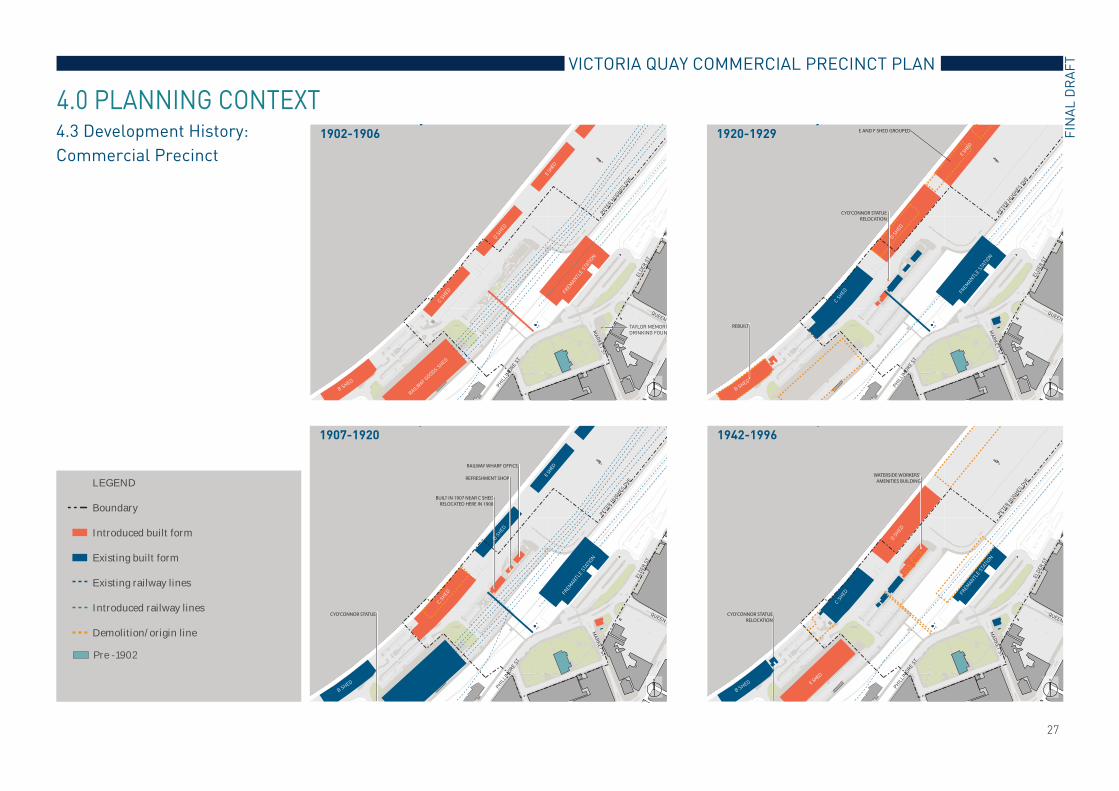
4.2 Development History: Victoria Quay
The maritime industry and port activities on Victoria Quay have left the imprint of a richly textured history which is evident in its buildings and structures, as well as many stories which add colourful interpretation to the place. The importance of Victoria Quay in the history of Fremantle and Western Australia is widely recognised and it has been included in the State Register of Heritage Places.More recently, there has been reduced port operational activity along the western end of Victoria Quay. Port activities are now principally concentrated at the eastern end of Victoria Quay and at North Quay leaving the western end potentially available for a range of community and commercial uses. Several studies have been undertaken to review the future of the western end of Victoria Quay and to help steer a coordinated urban renewal of Victoria Quay’s western end with the aim of transforming the area into a vibrant and desirable destination. The Fremantle Waterfront Masterplan (Cox Howlett and Bailey Woodland, 2000) provided the initial framework for the development of the western end of Victoria Quay for public and commercial uses.
This masterplan was followed by the Phillimore Street Integrated Masterplan (Donaldson and Warn, 2005) as well as a series of heritage studies and an interpretation plan which all provided greater and more informed appreciation
There have also been various technical investigations into the condition of the services within the site and the structural integrity of the wharf, slipways, cranes and other maritime structures.In 1993, the State Government negotiated the return of America’s Cup winning yacht Australia II from Sydney. The subsequent construction of the Western Australian Maritime Museum at Forrest Landing to house the famous yacht, was the catalyst for the introduction of urban uses in the western end of Victoria Quay. With the Western Australian Maritime Museum as a key public attraction and focal point, the development of the common user berth for ferries (O’Connor Landing), and the refurbishment of B Shed, the redevelopment of the historic Victoria Quay into an attractive and popular destination is well underway.The Commercial Precinct will play an important role in the revitalisation of Victoria Quay. The development objectives presented in the Fremantle Waterfront Masterplan will be achieved by attracting public and private investment in infrastructure, heritage
PROJECT AREA
2000 Masterplan Boundary
Current Precinct Plan Boundary
Buildings still requiring signifi-cant work to accomplish mas-terplan
Buildings that do not require significant work to accomplish masterplan
Urban realm still requiring significant work to accomplish masterplan
Urban realm that does not require significant work to accomplish masterplan
D Shed not included in2000 FWMPI
2000 Fremantle Waterfront Masterplan Implementation
4.0 PLANNING CONTEXT
Land reclaimed since 1833
Land dredged since 1833
restoration and development projects that will complement existing activities in Fremantle. The transformation of Victoria Quay’s western end and its improved integration with Fremantle will continue in an incremental way with coordinated works undertaken in several stages.
Past and Present Land Comparison
Land reclaimed since 1833
Land dredged since 1833
2000 Masterplan Boundary
Current Precinct Plan Boundary
Buildings still requiring signifi-cant work to accomplish mas-terplan
Buildings that do not require significant work to accomplish masterplan
Urban realm still requiring significant work to accomplish masterplan
Urban realm that does not require significant work to accomplish masterplan
D Shed not included in2000 FWMPI
N
27
VICTORIA QUAY COMMERCIAL PRECINCT PLAN
FIN
AL
DR
AF
T
TAYLOR MEMORI
DRINKING FOUN
E SHED
RAILW
AY GOODS S
HED
y1902-1906
LEGEND
Boundary
Introduced built form
Existing built form
Existing railway lines
Introduced railway lines
Demolition/origin line
ELD
ER
ST
QUEEN
MA
RK
ET
ST
PH
ILLI
MO
RE S
T
PETE
R H
UG
HES
DVE
FREM
AN
TLE S
TATI
ON
D S
HED
C S
HED
B SHED
CYO’CONNOR STATUE
BUILT IN 1907 NEAR C SHEDRELOCATED HERE IN 1908
E SHED
REFRESHMENT SHOP
RAILWAY WHARF OFFICE
y1907-1920
LEGEND
Boundary
Introduced built form
Existing built form
Existing railway lines
Introduced railway lines
Demolition/origin line
ELD
ER
ST
QUEEN S
MA
RK
ET
ST
PH
ILLI
MO
RE S
T
PETE
R H
UG
HES
DVE
FREM
AN
TLE S
TATI
ON
D S
HED
C S
HED
B SHED
CYO’CONNOR STATUERELOCATION
E AND F SHED GROUPED
REBUILT
E SHED
y1920-1929
LEGEND
Boundary
Introduced built form
Existing built form
Existing railway lines
Introduced railway lines
Demolition/origin line
ELD
ER
ST
QUEEN
MA
RK
ET
ST
PH
ILLI
MO
RE S
T
PETE
R H
UG
HES
DVE
FREM
AN
TLE S
TATI
ON
D S
HED
C S
HED
B SHED
CYO’CONNOR STATUERELOCATION
E SHED
WATERSIDE WORKERS’ AMENITIES BUILDING
y1942-1996
LEGEND
Boundary
Introduced built form
Existing built form
Existing railway lines
Introduced railway lines
Demolition/origin line
ELD
ER
ST
QUEEN
MA
RK
ET
ST
PH
ILLI
MO
RE S
T
PETE
R H
UG
HES
DVE
FREM
AN
TLE S
TATI
ON
D S
HED
C S
HED
B SHED
4.3 Development History:
Commercial Precinct
4.0 PLANNING CONTEXT
LEGEND
Boundary
Introduced built form
Existing built form
Existing railway lines
Introduced railway lines
Demolition/origin line
Pre -1902
N
N N
N

28
Quarry
Ferry
Point
King’s
Square
Bather’s Bay
South Bay
Arthur’s
Head
Rous Head
Shoal Bay
Crab Bay
Shipping route
Carriage/ motor vehicle passage
Gaol
Queen’s
SquareKing’s
Square
Bather’s Bay
C Shed
Railway
Bridge
Lunatic
Asylum
Public Park
North Fremant
Bridge
Fremantle
Oval
D Shed
E Shed
Cliff Street
Train Station
Passenger
Railway Station
Barracks
Rous Head
North Mole
South Mole
Shipping route
Carriage/ motor vehicle passage
Railway route
Tram route
Convict
Establishment
Recreation
Green
Queen’s
Square
South
J tt
North
Jetty
Ferry
Point
King’s
Square
Bather’s
Bay South Bay
Rous Head
Shoal
Bay
Crab bay
Lunatic Asylum
Public Park
Quarry
North Fremantle bridge
(incomplete)
Gaol
Queen’s
SquareKing’s
Square
Bather’s
Bay
C Shed
Public Park
North Fremantle
Bridge
Fremantle Oval
D Shed
E Shed
Train
Station
Barracks
Rous Head
North Mole
South Mole
Wheat Silos
Wool Stores
Wool Stores
Passenger
Terminal
Railway
Bridge
Fishing Boat
Shipping route
Carriage/ motor vehicle passage
Railway route
Tram route
4.0 PLANNING CONTEXT
1865 1960
1840 1905
Shipping route
Carriage/ motor vehicle passage
Railway route
Tram route
N
N N
N
4.4 Development History: City of Fremantle, Fremantle Railway Station and the Port

29
VICTORIA QUAY COMMERCIAL PRECINCT PLAN
FIN
AL
DR
AF
T
4.0 PLANNING CONTEXT
PHILLIMORE STREET INTEGRATED MASTERPLAN
In 2007, the City of Fremantle adopted the Phillimore Street Integrated Masterplan as a framework for a major upgrade of the Phillimore Street precinct.
opportunities to revitalise this part of Fremantle and, importantly, to improve linkages between the Fremantle city centre and the Victoria Quay waterfront. The planning integrated the needs of the city, the port and public transport to produce the best possible outcome for the community. The Phillimore Street Plan also proposed an alternative Bus Interchange which included direct access from Market Street. AMENDMENT 49
Amendment 49 to Local Planning
Amendment establish primary planning requirements for the key development sites in and around Kings Square extending towards the railway. The Amendment is important because it encourages higher density development with increased heights of buildings and stipulates setback from their road boundary. An increase in local residents within close proximity to Fremantle Station and Bus Interchange and optimum pedestrian access to these services will be increasingly important.
A number of important studies and plans has been undertaken by the City of Fremantle in recent years which underpin future development of Fremantle. These include:
City of Fremantle Strategic Plan 2010 -2015
Fremantle Retail Model PlanCity of Fremantle’s Economic
Development Strategy 2011 - 2015.These documents can be found on the City of Fremantle website.PRIMARY ACTIVITY CENTRE STRUCTURE PLAN
Directions 2031 is a high level spatial framework and strategic plan prepared by the State Government. It establishes a Vision for future growth of the metropolitan Perth and Peel region. It provides a framework to guide the detailed planning and delivery of housing, infrastructure and services necessary to accommodate a range of growth scenarios. The City of Fremantle is one of the potential Primary Activity Centres
achieve this status, the City of Fremantle is required to prepare a Structure Plan which sets out a more detailed spatial
future development in Fremantle. The Victoria Quay Commercial Precinct Plan, Fremantle Railway Station Precinct
Plan and Pioneer Park Precinct Plan will be incorporated into the Structure Plan when it is completed.FREMANTLE WEST END CONSERVATION AREA POLICY
The West End is the original Fremantle town centre as laid out in 1829. It is rich in history and heritage value. The entire area is entered in the Register of the National Estate. As such, the impact of any development in the Commercial Precinct needs to consider its impact on the West End.
Amendment 49 Lots
Amendment 49
17.5m
21m
21m
17.5-21m
14-21m
14-21m 17.5m
14m
14m
19m
17.5m
14-17.5m
MA
RK
ET
ST
QUEEN ST
EL
DE
R S
T
PA
KE
NH
AM
ST
HIGH ST
LEGEND
Fremantle Station
N
4.5 Development History: City of Fremantle
The objective of this policy is to create an awareness of the West End heritage so as to enable preservation and enhancement of the area and to facilitate sympathetic redevelopment whilst giving guidance to the Council’s discretionary powers under Town Planning Scheme No. 3.

10 ELDER PLACE, FREMANTLEPO BOX 671, WA 6159
TEL: (08) 9433 6000FAX: (08) 9433 3700www.coda-studio.com