Victor Harbor Council Development Plan - DPTI€¦ · Council Development Plan since inception of...
449
Victor Harbor Council Consolidated – 20 June 2017 Please refer to the Victor Harbor Council page at www.sa.gov.au/developmentplans to see any amendments not consolidated. Consolidated - 20 June 2017
Transcript of Victor Harbor Council Development Plan - DPTI€¦ · Council Development Plan since inception of...

Victor Harbor Council
Consolidated – 20 June 2017
Please refer to the Victor Harbor Council page at www.sa.gov.au/developmentplans to see any amendments not consolidated.
Consolidated - 20 June 2017
Department of Planning, Transport and Infrastructure
Level 5 50 Flinders Street Adelaide
Postal Address GPO Box 1815 Adelaide SA 5001
Phone (08) 7109 7099 Fax (08) 8303 0782
Email [email protected] Internet www.saplanningportal.sa.gov.au
City of Victor Harbor
1 Bay Road Victor Harbor SA Australia 5211 Postal Address PO Box 11 Victor Harbor SA 5211 Phone (08) 8551 0500 Fax (08) 8551 0501 Email [email protected] Internet www.victor.sa.gov.au
Consolidated - 20 June 2017
Victor Harbor Council Table of Contents
Table of Contents
Introduction Section 1
Consolidation of Amendments Table ..................................................................................... 3
Introduction to the Development Plan ................................................................................... 5
Council Preface Map .............................................................................................................. 10
General Section 11
Advertisements ...................................................................................................................... 13 Safety ........................................................................................................................................................ 14 Freestanding Advertisements ................................................................................................................... 14 Flags, Bunting and Streamers .................................................................................................................. 15 Advertising along Arterial Roads .............................................................................................................. 15
Animal Keeping ...................................................................................................................... 16 Horse Keeping .......................................................................................................................................... 16 Dairies ....................................................................................................................................................... 17 Intensive Animal Keeping ......................................................................................................................... 17
Bulk Handling and Storage Facilities ................................................................................... 20
Centres and Retail Development .......................................................................................... 21 Arterial Roads ........................................................................................................................................... 22 Retail Development................................................................................................................................... 22
Coastal Areas ......................................................................................................................... 24 Environmental Protection .......................................................................................................................... 24 Maintenance of Public Access .................................................................................................................. 25 Hazard Risk Minimisation ......................................................................................................................... 26 Erosion Buffers ......................................................................................................................................... 27 Land Division ............................................................................................................................................ 27 Protection of Economic Resources ........................................................................................................... 27 Development in Appropriate Locations ..................................................................................................... 28
Community Facilities ............................................................................................................. 29
Crime Prevention .................................................................................................................... 30
Design and Appearance ........................................................................................................ 31 Building Setbacks from Road Boundaries ................................................................................................ 32
Energy Efficiency ................................................................................................................... 34 On-site Energy Generation ....................................................................................................................... 34
Forestry ................................................................................................................................... 35
Hazards ................................................................................................................................... 37
Consolidated - 20 June 2017

Victor Harbor Council Table of Contents
Flooding.................................................................................................................................................... 37 Bushfire .................................................................................................................................................... 38 Salinity ...................................................................................................................................................... 39 Acid Sulfate Soils ..................................................................................................................................... 39 Site Contamination ................................................................................................................................... 39 Containment of Chemical and Hazardous Materials ............................................................................... 39 Landslip .................................................................................................................................................... 40
Heritage Places ....................................................................................................................... 41
Historic Conservation Area ................................................................................................... 43
Industrial Development .......................................................................................................... 45 Small-scale agricultural industries, home-based industries, mineral water extraction and processing plants, and wineries in rural areas ........................................................................................................... 46
Infrastructure .......................................................................................................................... 50
Interface between Land Uses ................................................................................................ 52 Noise Generating Activities .................................................................................................................. 52 Air Quality ................................................................................................................................................. 53 Rural Interface .......................................................................................................................................... 53
Land Division .......................................................................................................................... 55 Design and Layout ................................................................................................................................... 56 Roads and Access ................................................................................................................................... 58 Land Division in Rural Areas .................................................................................................................... 59
Landscaping, Fences and Walls ........................................................................................... 60
Marinas and Maritime Structures .......................................................................................... 62
Mineral Extraction................................................................................................................... 63 Separation Treatments, Buffers and Landscaping .................................................................................. 64
Natural Resources .................................................................................................................. 65 Water Sensitive Design ............................................................................................................................ 66 Water Catchment Areas ........................................................................................................................... 67 Biodiversity and Native Vegetation .......................................................................................................... 68 Soil Conservation ..................................................................................................................................... 70
Open Space and Recreation .................................................................................................. 71
Orderly and Sustainable Development ................................................................................. 74
Renewable Energy Facilities ................................................................................................. 75 Wind Farms and Ancillary Development .................................................................................................. 75
Residential Development ....................................................................................................... 77 Design and Appearance........................................................................................................................... 77 Overshadowing ........................................................................................................................................ 78 Garages, Carports and Outbuildings ....................................................................................................... 78 Street and Boundary Setbacks ................................................................................................................ 79 Site Coverage .......................................................................................................................................... 81
Consolidated - 20 June 2017

Victor Harbor Council Table of Contents
Private Open Space .................................................................................................................................. 82 Site Facilities and Storage ........................................................................................................................ 83 Visual Privacy ........................................................................................................................................... 83 Noise ......................................................................................................................................................... 84 Car Parking and Access ........................................................................................................................... 85 Undercroft Garaging of Vehicles ............................................................................................................... 85 Dependent Accommodation ..................................................................................................................... 86 Swimming Pools and Outdoor Spas ......................................................................................................... 86
Short-Term Workers Accommodation ................................................................................. 87
Siting and Visibility ................................................................................................................ 88
Sloping Land ........................................................................................................................... 90
Supported Accommodation, Housing for Aged Persons and People with Disabilities ... 91
Telecommunications Facilities ............................................................................................. 94
Tourism Development ............................................................................................................ 95 Tourism Development in Association with Dwelling(s) ............................................................................. 95 Tourism Development Outside Townships ............................................................................................... 96 Residential Parks and Caravan and Tourist Parks ................................................................................... 97
Transportation and Access ................................................................................................... 98 Land Use ................................................................................................................................................... 98 Movement Systems .................................................................................................................................. 98 Cycling and Walking ................................................................................................................................. 99 Access .................................................................................................................................................... 100 Access for People with Disabilities ......................................................................................................... 100 Vehicle Parking ....................................................................................................................................... 100
Waste ..................................................................................................................................... 103 Wastewater ............................................................................................................................................. 104 Waste Treatment Systems ..................................................................................................................... 104
Waste Management Facilities ............................................................................................. 106
Zone Section 109
Caravan and Tourist Park Zone .......................................................................................... 111
Coastal Conservation Zone ................................................................................................. 115 Precinct 1 Granite Island Tourist Facilities ......................................................................................... 116
Coastal Open Space Zone ................................................................................................... 120
Commercial Zone ................................................................................................................. 125
Deferred Urban Zone ............................................................................................................ 128
Light Industry Zone .............................................................................................................. 131 Home Industry Policy Area 1 .................................................................................................................. 133
Consolidated - 20 June 2017
Victor Harbor Council Table of Contents
Local Centre Zone ................................................................................................................ 137 Hayborough East Policy Area 3 ............................................................................................................. 139 Yilki Policy Area 4 .................................................................................................................................. 140
Mixed Use Zone .................................................................................................................... 144
Neighbourhood Centre Zone ............................................................................................... 147
Open Space Zone ................................................................................................................. 152 Golf Course Policy Area 5 ...................................................................................................................... 155
Primary Production (Mount Lofty Ranges) Zone ............................................................... 158 Coastal Policy Area 6 ............................................................................................................................. 163
Regional Centre Zone ........................................................................................................... 174 Burke Street Character Policy Area 7 .................................................................................................... 178 Business Policy Area 8 .......................................................................................................................... 180 Town Centre Character Policy Area 9 ................................................................................................... 185 Shopping Policy Area 10 ........................................................................................................................ 189 Visitor Facilities Policy Area 11 .............................................................................................................. 191
Residential Zone ................................................................................................................... 200 Bay Road Policy Area 12 ....................................................................................................................... 204 Encounter Bay Policy Area 13 ............................................................................................................... 205 Hayborough Policy Area 14 ................................................................................................................... 207 Hayborough North Policy Area 15 ......................................................................................................... 209 Canterbury West Policy Area 16 ............................................................................................................ 211 Hindmarsh River Policy Area 17 ............................................................................................................ 213 Hindmarsh Valley Policy Area 18 ........................................................................................................... 214
Precinct 2 Adelaide - Victor Harbor Road ......................................................................................... 218 Precinct 3 Strawberry Hill Road ........................................................................................................ 218 Precinct 4 Waggon Road North ......................................................................................................... 219 Precinct 5 Waggon Road South ........................................................................................................ 220
Lakeside Policy Area 19 ......................................................................................................................... 222 McCracken Golf Course Policy Area 20 ................................................................................................ 224 Mount Breckan Policy Area 21 ............................................................................................................... 226 Town Centre Policy Area 22 .................................................................................................................. 228 Waitpinga Policy Area 23 ....................................................................................................................... 230 Waterfront Policy Area 24 ...................................................................................................................... 232 Yilki Residential Policy Area 25 ............................................................................................................. 235
Residential Park Zone .......................................................................................................... 239
Rural Living Zone ................................................................................................................. 243 Hills Policy Area 26 ................................................................................................................................ 245 Crozier Hill Policy Area 27 ..................................................................................................................... 247 Morgan Park Policy Area 28 .................................................................................................................. 249 Rural Living North Policy Area 29 .......................................................................................................... 251
Suburban Neighbourhood Zone .......................................................................................... 255
Consolidated - 20 June 2017

Victor Harbor Council Table of Contents
Tourist Accommodation Zone ............................................................................................ 263 Inman River Tourist Recreation Policy Area 30 ...................................................................................... 264 Whalers Inn Policy Area 31 .................................................................................................................... 265
Watershed Protection (Mount Lofty Ranges) Zone ........................................................... 268
Table Section 283
Table ViH/1 - Building Setbacks from Road Boundaries .................................................. 285
Table ViH/2 - Off Street Vehicle Parking Requirements .................................................... 286
Table ViH/3 - Off Street Bicycle Parking Requirements .................................................... 289
Table ViH/4 - Local Heritage Places .................................................................................... 290
Table ViH/5 - State Heritage Places .................................................................................... 308
Mapping Section 311
Map Reference Tables ......................................................................................................... 313 Index Maps ............................................................................................................................................. 313 Zone Maps .............................................................................................................................................. 313 Policy Area Maps .................................................................................................................................... 314 Precinct Maps ......................................................................................................................................... 315 Historic Conservation Area Maps ........................................................................................................... 315 Overlay Maps .......................................................................................................................................... 315 Bushfire Protection Overlay Maps .......................................................................................................... 315 Concept Plan Maps ................................................................................................................................ 315
Spatial Extent Maps ............................................................................................................. 317
Bushfire Risk BPA Maps ..................................................................................................... 415
Concept Plan Maps .............................................................................................................. 425
Copyright
© Government of South Australia. All rights reserved. The document may be reproduced free-of-charge in any format providing that it is reproduced accurately and not used in any misleading context. The material must be acknowledged as Government of South Australia copyright and the title of the document specified.
Disclaimer
Although every effort has been made to ensure the accuracy of the information contained in this document, the Government of South Australia, its agents, officers and employees make no representations, either express or implied, that the information contained is accurate or fit for any purpose and expressly disclaims all liability for loss or damage arising from reliance upon the information supplied. Persons using this information should consult the relevant Gazette Notices and/or view an authorised copy of the subject Development Plan Amendment when exacting legal clarification on any amendment is required.
Consolidated - 20 June 2017

Consolidated - 20 June 2017

Victor Harbor Council Introduction Section
1
Introduction Section
Consolidated - 20 June 2017

Consolidated - 20 June 2017
Victor Harbor Council Introduction Section
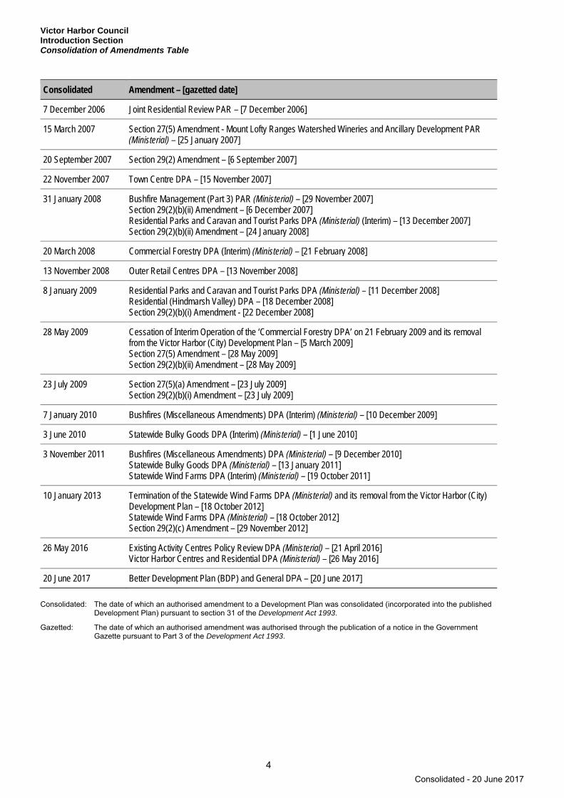
Consolidation of Amendments Table
3
Consolidation of Amendments Table
The following table is a record of authorised amendments and their consolidation dates for the Victor Harbor Council Development Plan since inception of the electronic Development Plan on 24 April 1997. Further information on authorised amendments prior to this date may be researched through the relevant Council, the Department of Planning, Transport and Infrastructure or by viewing Gazette records.
Consolidated Amendment – [gazetted date]
24 April 1997 Section 29(2) Amendment (Country and Outer Metro EDP) – [24 April 1997]
28 August 1997 Statewide Marine Aquaculture and Offshore Development PAR (Ministerial) – [5 June 1997]
25 September 1997 Section 29(2) Amendment – [25 September 1997]
24 September 1998 Tourist Accommodation (Whaler’s Inn) Zone PAR – [24 September 1998]
13 November 1998 Recreation/Amusement (Hindmarsh River) Zone PAR – [13 November 1998]
19 August 1999 Waste Disposal (Landfill) PAR (Ministerial) – [19 August 1999] Rural Living 4 Zone PAR – [19 August 1999]
16 December 1999 Outer Metropolitan Adelaide Development Plans – Miscellaneous Amendments – Outer Metropolitan PAR (Ministerial) – [16 December 1999] Section 29(2)(a) Amendment – [16 December 1999]
13 July 2000 Bacchus Road PAR – [13 July 2000]
Not consolidated Telecommunications Facilities State-wide Policy Framework PAR (Interim) (Ministerial) – [31 August 2000]
5 October 2000 Section 27(5) Amendment - Waste Disposal (Landfill) PAR (Ministerial) – [9 March 2000] Small Scale Tourist Accommodation in Rural Areas of the Mount Lofty Ranges PAR (Ministerial) – [21 September 2000] Small Scale Rural/Agricultural and Home Based Industries PAR (Ministerial) – [21 September 2000]
12 July 2001 Mount Lofty Ranges Watershed Amendment PAR (Ministerial)
31 January 2002 Telecommunications Facilities State-wide Policy Framework PAR (Ministerial) – [30 August 2001] Bushfire Management PAR (Ministerial) – [6 September 2001] Organic Waste Processing (Composting) PAR (Interim) (Ministerial) – [20 December 2001]
3 October 2002 Local Heritage PAR (Interim) – [3 October 2002]
19 June 2003 Organic Waste Processing (Composting) PAR (Ministerial) – [5 December 2002] Section 29(2)(a) Amendment – [19 June 2003]
2 October 2003 Wind Farms PAR (Ministerial) – [24 July 2003] Local Heritage PAR – [2 October 2003]
13 November 2003 Local Heritage Review PAR (Interim) – [13 November 2003]
23 September 2004 Local Heritage Item PAR (Interim) – [23 September 2004] Editorial Correction to Table ViH/3
11 November 2004 Local Heritage Review PAR – [11 November 2004]
11 August 2005 Local Heritage Item PAR – [11 August 2005]
22 June 2006 Mount Lofty Ranges Watershed Wineries and Ancillary Development PAR (Ministerial) – [8 June 2006]
Consolidated - 20 June 2017
Victor Harbor Council Introduction Section Consolidation of Amendments Table
4
Consolidated Amendment – [gazetted date]
7 December 2006 Joint Residential Review PAR – [7 December 2006]
15 March 2007 Section 27(5) Amendment - Mount Lofty Ranges Watershed Wineries and Ancillary Development PAR (Ministerial) – [25 January 2007]
20 September 2007 Section 29(2) Amendment – [6 September 2007]
22 November 2007 Town Centre DPA – [15 November 2007]
31 January 2008 Bushfire Management (Part 3) PAR (Ministerial) – [29 November 2007] Section 29(2)(b)(ii) Amendment – [6 December 2007] Residential Parks and Caravan and Tourist Parks DPA (Ministerial) (Interim) – [13 December 2007] Section 29(2)(b)(ii) Amendment – [24 January 2008]
20 March 2008 Commercial Forestry DPA (Interim) (Ministerial) – [21 February 2008]
13 November 2008 Outer Retail Centres DPA – [13 November 2008]
8 January 2009 Residential Parks and Caravan and Tourist Parks DPA (Ministerial) – [11 December 2008] Residential (Hindmarsh Valley) DPA – [18 December 2008] Section 29(2)(b)(i) Amendment - [22 December 2008]
28 May 2009 Cessation of Interim Operation of the ‘Commercial Forestry DPA’ on 21 February 2009 and its removal from the Victor Harbor (City) Development Plan – [5 March 2009] Section 27(5) Amendment – [28 May 2009] Section 29(2)(b)(ii) Amendment – [28 May 2009]
23 July 2009 Section 27(5)(a) Amendment – [23 July 2009] Section 29(2)(b)(i) Amendment – [23 July 2009]
7 January 2010 Bushfires (Miscellaneous Amendments) DPA (Interim) (Ministerial) – [10 December 2009]
3 June 2010 Statewide Bulky Goods DPA (Interim) (Ministerial) – [1 June 2010]
3 November 2011 Bushfires (Miscellaneous Amendments) DPA (Ministerial) – [9 December 2010] Statewide Bulky Goods DPA (Ministerial) – [13 January 2011] Statewide Wind Farms DPA (Interim) (Ministerial) – [19 October 2011]
10 January 2013 Termination of the Statewide Wind Farms DPA (Ministerial) and its removal from the Victor Harbor (City) Development Plan – [18 October 2012] Statewide Wind Farms DPA (Ministerial) – [18 October 2012] Section 29(2)(c) Amendment – [29 November 2012]
26 May 2016 Existing Activity Centres Policy Review DPA (Ministerial) – [21 April 2016] Victor Harbor Centres and Residential DPA (Ministerial) – [26 May 2016]
20 June 2017 Better Development Plan (BDP) and General DPA – [20 June 2017]
Consolidated: The date of which an authorised amendment to a Development Plan was consolidated (incorporated into the published Development Plan) pursuant to section 31 of the Development Act 1993.
Gazetted: The date of which an authorised amendment was authorised through the publication of a notice in the Government Gazette pursuant to Part 3 of the Development Act 1993.
Consolidated - 20 June 2017

Victor Harbor Council Introduction Section
Introduction to the Development Plan
5
Introduction to the Development Plan
Welcome to the Development Plan for the City of Victor Harbor.
This introduction has been prepared by the Department of Planning, Transport and Infrastructure as guide to assist you in understanding this Development Plan.
For full details about your rights and responsibilities, you are advised to refer to the Development Act 1993 and the associated Development Regulations 2008 and / or consult your council.
A number of guides and additional information regarding South Australia’s Planning and Development Assessment System are available via the website www.saplanningportal.sa.gov.au or by contacting the Department of Planning, Transport and Infrastructure.
Overview of the Planning System South Australia has an integrated planning and development system, with three distinct but interrelated parts, these being:
▪ Legislation ▪ The Planning Strategy ▪ Development Plans.
The legislative framework establishing the planning and development system and setting out its statutory procedures is provided by the Development Act 1993 and its associated Development Regulations 2008. The Development Act is the core legislation enacted by the South Australian Parliament to establish the planning and development system framework and many of the processes required to be followed within that framework (including processes for assessing development applications). The Regulations provide more details about the framework and are updated from time to time by the Governor (on the advice of the Minister for Planning).
The State Government's broad vision for sustainable land use and the built development of the state is outlined in the Planning Strategy. The relevant volume of the Planning Strategy for this Development Plan is The 30-Year Plan for Greater Adelaide 2017 Update.
The Planning Strategy, which covers a full range of social, economic and environmental issues, informs and guides policies both across Government and in local area Development Plans. The Planning Strategy is required under section 22 of the Development Act and is updated by the State Government every few years. Local councils also prepare strategic plans which guide the same matters but at a local level. These strategic plans are not, however, development assessment tools: that is the role of Development Plans.
Development Plans are the key on-the-ground development assessment documents in South Australia. They contain the rules that set out what can be done on any piece of land across the state, and the detailed criteria against which development applications will be assessed. Development Plans cover distinct and separate geographic areas of the state. There is a separate Development Plan for each one of the 68 local council areas, plus a handful of other Development Plans covering areas not situated within local government boundaries. Development Plans outline what sort of developments and land use are and are not envisaged for particular zones (eg residential, commercial, industrial), and various objectives, principles and policies further controlling and affecting the design and other aspects of proposed developments.
What is Development? ‘Development’ is defined in Section 4 of the Development Act 1993 as:
▪ a change in the use of land or buildings ▪ the creation of new allotments through land division (including Strata and Community Title division) ▪ building work (including construction, demolition, alteration and associated excavation/fill)
Consolidated - 20 June 2017

Victor Harbor Council Introduction Section Introduction to the Development Plan
6
▪ cutting, damaging or felling of significant trees ▪ specific work in relation to State and Local heritage places ▪ prescribed mining operations ▪ other acts or activities in relation to land as declared by the Development Regulations.
No development can be undertaken without an appropriate Development Approval being obtained from the relevant authority after an application and assessment process.
How does the Development Plan relate to other legislation? The Development Plan is a self-contained policy document prepared under and given statutory recognition pursuant to the Development Act 1993.
It is generally independent of other legislation but is one of many mechanisms that control or manage the way that land and buildings are used.
The Development Act and Regulations contain a number of provisions to ensure that development applications are referred to other government agencies when appropriate.
What doesn’t a Development Plan do? Development Plans are applicable only when new development is being designed or assessed. They do not affect existing development (see above for a description of what constitutes ‘development’).
Once a Development Approval is issued, the details contained within the application and any conditions attached to that approval are binding.
Development Plan policies guide the point in time assessment of a development application but do not generally seek to control the on-going management of land, which is the role of other legislation (eg the Environment Protection Act 1993, Natural Resources Management Act 2004, Liquor Licensing Act 1997).
When do you use the Development Plan? The Development Plan should be used during a development application process. This may include:
▪ when undertaking or proposing to undertake ‘development’ (eg building a house or factory or converting an office into a shop)
▪ when assessing or determining a development proposal (eg by council staff, a Council or Regional Development Assessment Panel or the Development Assessment Commission)
▪ when you believe you could be affected by a proposed development and you are given an opportunity to comment on it as part of the assessment process.
How to read the Development Plan Development Plans are comprised of several sections as described below.
All sections and all relevant provisions within each section of the Development Plan must be considered in relation to a development proposal or application.
Development Plans use three text font colours:
(a) Black text is used to identify all standard policy that forms the basis of all council Development Plans.
(b) Green text is used to identify additional council-specific policy or variables that have been included in the Development Plan to reflect local circumstances.
(c) Blue text illustrates hyperlinks to maps, overlays and tables in the Development Plan. These hyperlinks are operational only when viewing electronic versions of the Development Plan.
Consolidated - 20 June 2017

Victor Harbor Council Introduction Section
Introduction to the Development Plan
7
Development Plan Structure Overview
Advisory Section Function
Table of Contents Navigational aid to reference sections within the Development Plan by name and page number.
Amendment Record Table Tabled information recording previously-authorised Development Plan amendments and their consolidation dates.
Introduction Overview of the Planning System What is Development? How does the Development Plan relate to other legislation? What doesn’t a Development Plan do? When do you use the Development Plan? How to read the Development Plan?
A general overview of the context, purpose and way a Development Plan is set out (this section is advisory only and not used for development assessment purposes).
Strategic Setting State Strategic Setting
(30-Year Plan for Greater Adelaide/Regional Planning Strategy)
Council Strategic Setting (Council Strategy)``
To be developed, but intended to reflect the relevant Planning Strategy (as it relates to the council area) and council’s own local strategic investigations.
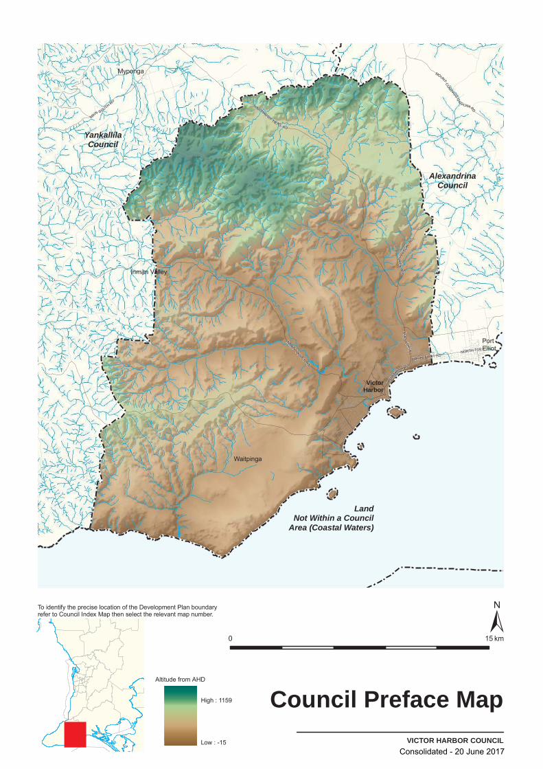
Council Preface Map Map of the entire Development Plan boundary and its spatial relationship to other Development Plans’ boundaries.
Assessment Section Function
General Provisions Objectives Principles of Development Control
These policies apply across the whole council area and relate to a range of social, environmental, and economic development issues such as:
▪ site and design criteria ▪ access and vehicle parking requirements ▪ heritage and conservation measures ▪ environmental issues ▪ hazards ▪ infrastructure requirements ▪ land use specific requirements.
They establish the development standards that apply to all forms of development and provide a yardstick against which the suitability of development proposals is measured.
Zone Provisions These policies give greater certainty and direction about where certain forms of developments should be located. Maps are referenced within zones that show where land uses are suitable to be located.
Generally, envisaged forms of development within a zone are identified and encouraged through carefully worded policies.
Consolidated - 20 June 2017

Victor Harbor Council Introduction Section Introduction to the Development Plan
8
Assessment Section Function
Desired Character Statements These express a vision about how the zone should look and feel in the future. They may describe the valued elements of the neighbourhood or area to be retained and/or what level and nature of change is desired.
Objectives These are the specific planning polices that determine what land uses are encouraged or discouraged in the zone. They often contain detailed provisions to further guide the scale and design of development.
Principles of Development Control These also provide lists of complying and non-complying development and any public notification provisions that vary from those in the Development Regulations.
Policy Area Policy areas apply to a portion of a zone and contain additional objectives, desired character statements and principles of development control for that portion.
Precincts Precincts are used to express policies for a small sub-area of a zone or a policy area.
Precincts are used if additional site-specific principles of development control are needed to reflect particular circumstances associated with those sub-areas.
Procedural Matters All zones have a procedural matters section that identifies and lists complying, non-complying and public notification categories for various forms of development.
Policy areas and/or precincts, which are a sub-set of the zone, share this procedural matters section. Their respective lists can be modified to accommodate policy area and precinct variations.
Tables These tables provide detailed data for the assessment of certain elements of development, for example, numeric values for setbacks from road boundaries and car parking rates for certain types of development.
Conditions for complying development are grouped into their respective tables.
Mapping Structure Plan Maps Structure Plan maps will commonly show the general
arrangement and broad distribution of land uses; key spatial elements; and movement patterns throughout the council area and major urban areas.
Council Index Maps This is the first point of reference when determining the appropriate map(s) applying to a specific property.
An enlargement index map may be included where needed, eg for large townships.
Consolidated - 20 June 2017
Victor Harbor Council Introduction Section
Introduction to the Development Plan
9
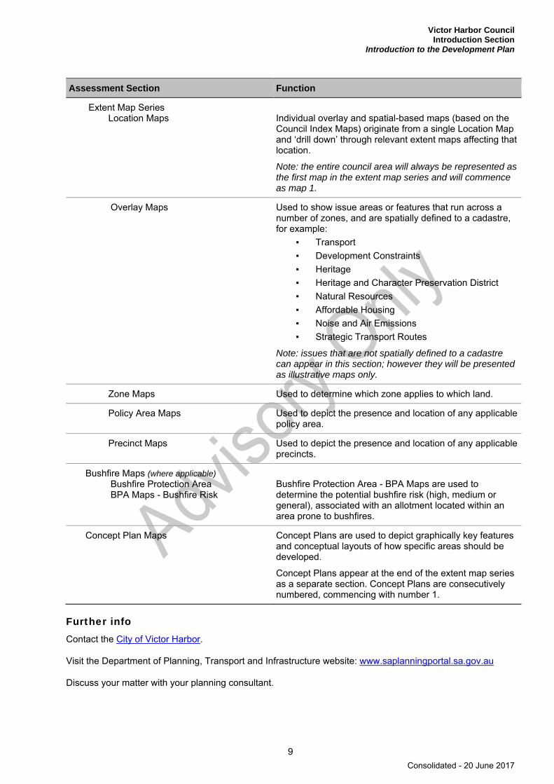
Assessment Section Function
Extent Map Series Location Maps Individual overlay and spatial-based maps (based on the
Council Index Maps) originate from a single Location Map and ‘drill down’ through relevant extent maps affecting that location.
Note: the entire council area will always be represented as the first map in the extent map series and will commence as map 1.
Overlay Maps Used to show issue areas or features that run across a number of zones, and are spatially defined to a cadastre, for example:
▪ Transport ▪ Development Constraints ▪ Heritage ▪ Heritage and Character Preservation District ▪ Natural Resources ▪ Affordable Housing ▪ Noise and Air Emissions ▪ Strategic Transport Routes
Note: issues that are not spatially defined to a cadastre can appear in this section; however they will be presented as illustrative maps only.
Zone Maps Used to determine which zone applies to which land.
Policy Area Maps Used to depict the presence and location of any applicable policy area.
Precinct Maps Used to depict the presence and location of any applicable precincts.
Bushfire Maps (where applicable) Bushfire Protection Area BPA Maps - Bushfire Risk
Bushfire Protection Area - BPA Maps are used to determine the potential bushfire risk (high, medium or general), associated with an allotment located within an area prone to bushfires.
Concept Plan Maps Concept Plans are used to depict graphically key features and conceptual layouts of how specific areas should be developed.
Concept Plans appear at the end of the extent map series as a separate section. Concept Plans are consecutively numbered, commencing with number 1.
Further info Contact the City of Victor Harbor.
Visit the Department of Planning, Transport and Infrastructure website: www.saplanningportal.sa.gov.au
Discuss your matter with your planning consultant.
Consolidated - 20 June 2017
LandNot Within a Council
Area (Coastal Waters)
AlexandrinaCouncil
YankallilaCouncil
Myponga
PortElliot
Inman Valley
Waitpinga
VictorHarbor
AD
ELAIDE
RD
HIND
MAR
SH RD
VIC
TOR
HARB
OR
RD
HINDMARSHT IERS
RD
INMANVALLEY
RD
NORTH TCE
PORT ELLIOT RD
MOUNTCO
MPASS-G
O
OLWARD
MAIN SOUTH RD
VICTOR HARBOR COUNCIL
Council Preface Map
0 15 km
To identify the precise location of the Development Plan boundaryrefer to Council Index Map then select the relevant map number.
Altitude from AHD
High : 1159
Low : -15Consolidated - 20 June 2017

Victor Harbor Council General Section
11
General Section
Consolidated - 20 June 2017

Consolidated - 20 June 2017
Victor Harbor Council General Section Advertisements
13
Advertisements
OBJECTIVES
1 Urban and rural landscapes that are not disfigured by advertisements and/or advertising hoardings.
2 Advertisements and/or advertising hoardings that do not create a hazard.
3 Advertisements and/or advertising hoardings designed to enhance the appearance of the building and locality.
PRINCIPLES OF DEVELOPMENT CONTROL
1 The location, siting, design, materials, size, and shape of advertisements and/or advertising hoardings should be:
(a) consistent with the predominant character of the urban or rural landscape
(b) in harmony with any buildings or sites of historic significance or heritage value in the area
(c) coordinated with and complement the architectural form and design of the building they are to be located on.
2 The number of advertisements and/or advertising hoardings associated with a development should be minimised to avoid:
(a) clutter
(b) disorder
(c) untidiness of buildings and their surrounds
(d) driver distraction.
3 Buildings occupied by a number of tenants should exhibit coordinated and complementary advertisements and/or advertising hoardings to identify the tenants and their type of business.
4 The content of advertisements should be limited to information relating to the legitimate use of the associated land.
5 Advertisements and/or advertising hoardings should:
(a) be completely contained within the boundaries of the subject allotment
(b) be sited to avoid damage to, or pruning or lopping of, on-site landscaping or street trees
(c) not obscure views to vistas or objects of high amenity value.
6 Advertisements and/or advertising hoardings should not be erected on:
(a) a public footpath or veranda post
(b) a road, median strip or traffic island
(c) a vehicle adapted and exhibited primarily as an advertisement
Consolidated - 20 June 2017
Victor Harbor Council General Section Advertisements
14
(d) residential land.
7 Advertisements and/or advertising hoardings attached to buildings should not be sited on the roof or higher than the walls of a building unless the advertisement or advertising hoarding is appropriately designed to form an integrated and complementary extension of the existing building.
8 Advertisements and/or advertising hoardings erected on a veranda or that project from a building wall should:
(a) have a clearance over a footway to allow for safe and convenient pedestrian access
(b) where erected on the side of a veranda, not exceed the width of the veranda or project from the veranda
(c) where erected on the front of a veranda, not exceed the length of the veranda or project from the veranda
(d) where projecting from a wall, have the edge of the advertisement or advertising hoarding abutting the surface of the wall.
9 Advertisements should be designed to conceal their supporting advertising hoarding from view.
10 Advertisements should convey the owner/occupier and/or generic type of business, merchandise or services using simple, clear and concise language, symbols, print style and layout and a small number of colours.
11 Advertisements which perform a secondary role in identifying the business, goods or services should only be readable in the immediate vicinity of the site.
12 Outside of townships and country settlements advertisements other than traffic signs, tourist signs or advertisements on an existing tourist information bay display board, should not be erected in road reserves.
Safety 13 Advertisements and/or advertising hoardings should not create a hazard by:
(a) being so highly illuminated as to cause discomfort to an approaching driver, or to create difficulty in the driver’s perception of the road or persons or objects on the road
(b) being liable to interpretation by drivers as an official traffic sign, or convey to drivers information that might be confused with instructions given by traffic signals or other control devices, or impair the conspicuous nature of traffic signs or signals
(c) distracting drivers from the primary driving task at a location especially where the demands on driver concentration are high
(d) obscuring a driver's view of other road or rail vehicles at/or approaching level crossings, or of pedestrians or of features of the road that are potentially hazardous (eg junctions, bends, changes in width, traffic control devices).
14 Any internally illuminated advertising signs and/or advertising hoardings which utilise LED, LCD or other similar technologies should be located a minimum of 80 metres from traffic signals, level crossings and other important traffic control devices.
Freestanding Advertisements 15 Freestanding advertisements and/or advertising hoardings should be:
(a) limited to only one primary advertisement per site or complex
Consolidated - 20 June 2017

Victor Harbor Council General Section Advertisements
15
(b) of a scale and size in keeping with the desired character of the locality and compatible with the development on the site.
16 Freestanding advertisements and/or advertising hoardings for multiple-business tenancy complexes should:
(a) incorporate the name or nature of each business or activity within the site or complex in a single advertisement
(b) be integrally designed and mounted below the more predominant main complex or site identity advertisement.
17 Portable, easel or A-frame advertisements should be displayed only where:
(a) no other appropriate opportunity exists for an adequate coordinated and permanently erected advertisement and/or advertising hoarding
(b) they do not obstruct or compromise the safety of pedestrians or vehicle movement
(c) there is no unnecessary duplication or proliferation of advertising information
(d) there is no damage to, or removal of, any landscaping on the site.
18 Portable, easel or A-frame advertisements associated with a development should be displayed only during the hours the development is open for trading.
Flags, Bunting and Streamers 19 Advertisements and/or advertising hoardings incorporating any flags, bunting, streamers, or suspended
objects should:
(a) be placed or arranged to complement and accord with the scale of the associated development
(b) other than flags, not be positioned higher than the building they are attached or related to
(c) not be displayed in residential areas.
Advertising along Arterial Roads 20 Advertising and/or advertising hoardings should not be placed along arterial roads that have a speed
limit of 80 km/h or more.
Consolidated - 20 June 2017
Victor Harbor Council General Section Animal Keeping
16
Animal Keeping
OBJECTIVES
1 Animals not kept at a density beyond the carrying capacity of the land or water.
2 Animal keeping development sited and designed to avoid adverse effects on surrounding development.
3 Intensive animal keeping protected from encroachment by incompatible development.
4 Ecological sustainable development of the aquaculture industry.
5 Marine aquaculture development in marine waters that ensures fair and equitable sharing of marine and coastal resources and minimises conflict with water-based and land-based uses.
PRINCIPLES OF DEVELOPMENT CONTROL
1 Animal keeping and associated activities should not create adverse impacts on the environment or the amenity of the locality.
2 Storage facilities for manure, used litter and other wastes should be designed and sited:
(a) to be vermin proof
(b) with an impervious base
(c) to ensure that all clean rainfall runoff is excluded from the storage area
(d) outside the 1-in-100 year average return interval flood event area.
Horse Keeping 3 Stables, horse shelters or associated yards should be sited:
(a) at least 50 metres from a watercourse
(b) on land with a slope no greater than 1-in-10.
4 A concrete drainage apron should be provided along the front of stables directing water from wash-down areas onto a suitably vegetated area that can absorb all the water, or into a constructed drainage pit.
5 Stables, horse shelters or associated yards should be sited at least 30 metres from any dwelling on the site and from the nearest allotment boundary to avoid adverse impacts from dust, erosion and odour.
6 All areas accessible to horses should be separated from septic tank drainage areas.
7 An area should be made available on each site where horses are kept to allow for the loading and unloading of horses, fodder and other goods and materials or wastes brought to or removed from the land.
8 Adequate dust suppression techniques should be used wherever necessary in sand and like-filled areas.
9 The open space around the stables and yards should be planted or surfaced with a suitable ground cover to minimise dust or erosion.
Consolidated - 20 June 2017

Victor Harbor Council General Section Animal Keeping
17
10 Horse keeping should only be undertaken if it complies with both (a) and (b):
(a) it will not detrimentally affect the character and amenity of the locality
(b) not more than two horses per hectare are kept.
Dairies 11 Dairies and associated wastewater lagoons and liquid/solid waste storage and disposal areas should be
located at a distance from nearby dwellings, public roads and outside the 1-in-100 year average return interval flood event area of any watercourse to avoid adverse impacts or nuisance by noise, smell or pollution on nearby sensitive receptors such as dwellings.
12 Dairies should include a lagoon for the storage or treatment of milking shed effluent which should be located:
(a) at least 20 metres from a public road
(b) at least 200 metres from any dwelling not located on the land
(c) outside any 1-in-100 year average return interval flood event area of any watercourse.
Intensive Animal Keeping 13 Intensive animal keeping operations and their associated components, including holding yards,
temporary feeding areas, movement lanes and similar, should not be located on land within any of the following areas:
(a) 800 metres of a public water supply reservoir
(b) the 1-in-100 year average return interval flood event area of any watercourse
(c) 200 metres of a major watercourse (third order or higher stream)
(d) 100 metres of any other watercourse, bore or well used for domestic or stock water supplies
(e) 2000 metres of a defined and zoned township, settlement or urban area (except for land based aquaculture)
(f) 500 metres of a dwelling (except for a dwelling directly associated with the intensive animal keeping facility).
14 Intensive animal keeping operations in uncovered situations should incorporate:
(a) a controlled drainage system which:
(i) diverts runoff from external areas, and
(ii) directs surface runoff into an effluent management system that has sufficient capacity to hold run off from the controlled drainage area
(b) pen floors which:
(i) ensure that effluent does not infiltrate and contaminate groundwater or soil, and
(ii) are graded to a consistent uniform slope of between 2 per cent and 6 per cent
(c) effluent drainage into an effluent lagoon(s) that has sufficient capacity to hold runoff from the controlled drainage area.
Consolidated - 20 June 2017
Victor Harbor Council General Section Animal Keeping
18
15 Intensive animal keeping facilities and associated wastewater lagoons and liquid/solid waste disposal areas should be sited, designed, constructed and managed to avoid adverse odour impacts on nearby sensitive land uses.
Kennels 16 The floor of kennels should be constructed of concrete or similar impervious material and be designed
to allow for adequate drainage when kennels are cleaned.
17 Kennels and exercise yards should be designed and sited to minimise noise nuisance to neighbours through:
(a) orienting their openings away from sensitive land uses such as dwellings
(b) siting them as far as practicable from allotment boundaries.
18 Kennels should occur only where there is a permanently occupied dwelling on the land.
Land Based Aquaculture 19 Land-based aquaculture and associated components should not be located on land within 500 metres
of a defined and zoned township, settlement or urban area.
20 Land-based aquaculture ponds should be sited and designed to:
(a) prevent surface flows from entering the ponds in a 1-in-100 year average return interval flood event
(b) prevent pond leakage that would pollute groundwater
(c) prevent the farmed species escaping and entering into any waters
(d) minimise the need for intake and discharge pipes to traverse sensitive environments.
21 Buildings associated with land-based aquaculture should provide enclosed storage areas to accommodate all equipment associated with aquaculture operations in a manner which is integrated with the use of the land.
22 Development should ensure that pipe inlet and outlets associated with land-based aquaculture are located to minimise the risk of disease transmission.
Marine Based Aquaculture 23 Marine aquaculture and other offshore development should be ecologically sustainable and be located,
designed, constructed and managed to:
(a) minimise adverse impacts on marine habitats and ecosystems, and public access to beaches, public watercourses or the foreshore
(b) take into account the requirements of traditional indigenous and commercial fishing grounds
(c) ensure satisfactory removal and disposal of litter, disused material, debris, detritus and dead animals from the development
(d) prevent the build up of waste.
24 In marine waters, marine aquaculture (other than inter tidal aquaculture) and other offshore development should be located a minimum of 100 metres seaward of the high-water mark.
25 Marine aquaculture development should not significantly obstruct or adversely affect any of the following:
Consolidated - 20 June 2017
Victor Harbor Council General Section Animal Keeping
19
(a) areas of high public use
(b) areas established for recreational activities
(c) areas of outstanding visual, environmental, commercial or tourism value
(d) sites, including beaches, used for recreational activities such as swimming, fishing, skiing, sailing and other water sports.
26 Marine aquaculture should be sited, designed, constructed and managed to minimise interference and obstruction to the natural processes of the coastal and marine environment.
27 Marine aquaculture should be developed in areas where an adequate water current exists to disperse sediments and be sited a sufficient height above the sea floor to:
(a) prevent the fouling of waters, publicly owned wetlands or the nearby coastline
(b) minimise seabed damage.
28 Racks, floats and other farm structures associated with marine aquaculture or other offshore development should where practicable be visually unobtrusive from the shoreline.
29 Marine aquaculture development should:
(a) use feed hoppers that are painted in subdued colours and suspended as low as possible above the water
(b) position structures to protrude the minimum distance practicable above water
(c) avoid the use of shelters and structures above cages and platforms unless necessary to exclude predators and protected species from interacting with the farming structures and/or stock inside the cages, or for safety reasons.
30 Marine aquaculture should be developed to maintain existing rights of way within or adjacent to a site.
31 Marine aquaculture access, launching and maintenance facilities should:
(a) where possible, use existing and established roads, tracks, ramps and paths to or from the sea
(b) be developed cooperatively and co-located.
32 Marine aquaculture and other offshore development should be located at least:
(a) 550 metres from a proclaimed shipwreck
(b) 1000 metres seaward from the boundary of any reserve under the National Parks and Wildlife Act 1972, unless a lesser distance is agreed with the Minister responsible for that Act.
33 Marine aquaculture development should be located so as not to obstruct nor interfere with navigation channels, access channels, frequently used natural launching sites, safe anchorage areas, known diving areas, commercial shipping lanes or activities associated with existing jetties and wharves.
34 Marine aquaculture development should contribute to navigational safety by being:
(a) suitably marked for navigational purposes
(b) sited to allow an adequate distance between farms for safe navigation
(c) located at least 250 metres from a commercial shipping lane
(d) comprised of structures that are secured and/or weighted to prevent drifting from the licensed site
(e) able to be rehabilitated when no longer operational.
Consolidated - 20 June 2017

Victor Harbor Council General Section Bulk Handling and Storage Facilities
20
Bulk Handling and Storage Facilities
OBJECTIVES
1 Facilities for the bulk handling and storage of agricultural and other commodities sited and designed to minimise adverse impacts on the landscape and on and from surrounding land uses.
PRINCIPLES OF DEVELOPMENT CONTROL
1 Facilities for the handling, storage and dispatch of commodities in bulk should be:
(a) located in bulk handling, industry or primary production type zones
(b) sited, designed and operated to minimise risks of contamination to the environment and adverse impacts on nearby sensitive land uses and from surrounding land uses.
2 Development of facilities for the handling, transportation and storage of bulk commodities should have:
(a) areas set aside on the site of the development for the marshalling and manoeuvring of vehicles attending the site
(b) roadways and parking areas surfaced in a manner sufficient to control dust emissions from the site
(c) vehicle circulation between activity areas contained within the site and without the need to use public roads
(d) landscaping, using locally indigenous plant species wherever practical, established within the site for the purpose of providing shade and shelter, and to assist with screening and dust filtration
(e) a buffer area for the establishment of dense landscaping adjacent road frontages
(f) security fencing around the perimeter of the site.
3 Temporary bunkers for storage should not compromise the efficient circulation and parking of vehicles within the site.
4 Access to and from the site should be designed to allow simultaneous movement of vehicles entering and exiting in a forward direction to minimise interference to other traffic using adjacent public roads.
Consolidated - 20 June 2017
Victor Harbor Council General Section
Centres and Retail Development
21
Centres and Retail Development
OBJECTIVES
1 Shopping, administrative, cultural, community, entertainment, educational, religious and recreational facilities located in integrated centres.
2 Centres that ensure rational, economic and convenient provision of goods and services and provide:
(a) a focus for community life
(b) safe, permeable, pleasant and accessible walking and cycling networks.
3 The provision of a safe pedestrian environment within centres which gives high priority to pedestrians, public and community transport.
4 Increased vitality and activity in centres through the introduction and integration of housing.
5 Centres developed in accordance with a hierarchy based on function, so that each type of centre provides a proportion of the total requirement of goods and services commensurate with its role.
6 Development of centres outside of Greater Adelaide in accordance with the following hierarchy:
(a) Regional Centre
(b) District Centre
(c) Town Centre (for smaller towns with a single centre zone)
(d) Local Centre (subsidiary centres for towns with a regional or district centre).
PRINCIPLES OF DEVELOPMENT CONTROL
1 Development within centres should:
(a) integrate facilities within the zone
(b) allow for the multiple use of facilities and the sharing of utility spaces
(c) allow for the staging of development within the centre
(d) be integrated with public and community transport.
2 Development within centres should be designed to be compatible with adjoining areas. This should be promoted through landscaping, screen walls, centre orientation, location of access ways, buffer strips and transitional use areas.
3 Development within centres should provide:
(a) public spaces such as malls, plazas and courtyards
(b) street furniture, including lighting, signs, litter bins, seats and bollards, that is sited and designed to complement the desired character
(c) unobtrusive facilities for the storage and removal of waste materials
Consolidated - 20 June 2017
Victor Harbor Council General Section Centres and Retail Development
22
(d) public facilities including toilets, infant changing facilities for parents, seating, litter bins, telephones and community information boards
(e) access for public and community transport and sheltered waiting areas for passengers
(f) lighting for pedestrian paths, buildings and associated areas
(g) a single landscaping theme
(h) safe and secure bicycle parking.
4 A single architectural theme should be established within centres through:
(a) constructing additions or other buildings in a style complementary to the existing shopping complex
(b) renovating the existing shopping complex to complement new additions and other buildings within the centre
(c) employing a signage theme.
5 The design of undercroft or semi-basement car parking areas should not detract from the visual quality and amenity of adjacent pedestrian paths, streets or public spaces.
6 Undercroft or semi-basement car parking areas should not project above natural or finished ground level by more than 1 metre.
Arterial Roads 7 Centres should develop on one side of an arterial road or in one quadrant of an arterial road
intersection.
8 Centre development straddling an arterial road should:
(a) concentrate on one side of the arterial road or one quadrant of the arterial road intersection
(b) minimise the need for pedestrian and vehicular movement from one part of the centre to another across the arterial road.
Retail Development 9 A shop or group of shops with a gross leaseable area of greater than 450 square metres should be
located within a centre zone.
10 A shop or group of shops with a gross leaseable area of less than 450 square metres should not be located on arterial roads unless within a centre zone.
11 A shop or group of shops located outside of zones that allow for retail development should:
(a) be of a size and type that will not hinder the development, function or viability of any centre zone
(b) not demonstrably lead to the physical deterioration of any designated centre
(c) be developed taking into consideration its effect on adjacent development.
12 Bulky goods outlets should only be located in centres and bulky goods zones.
13 Bulky goods outlets located within centres zones should:
(a) complement the overall provision of facilities
Consolidated - 20 June 2017
Victor Harbor Council General Section
Centres and Retail Development
23
(b) be sited towards the periphery of those centres where the bulky goods outlet has a gross leaseable area 500 square metres or more.
14 Outdoor dining should:
(a) provide sufficient set-backs from kerbs and property boundaries
(b) provide sufficient clearances from buildings
(c) be located in an area safe for patrons where the security of the building is not compromised
(d) ensure the dining area is set back from the building line at street intersections
(e) ensure it does not hinder free and uninterrupted pedestrian access along pedestrian pathways
(f) ensure wheelchair access to pedestrian ramps is not compromised.
15 Fixed glass screens, plastic blinds or freestanding removable canvas screens associated with outdoor dining should not create an enclosure or clutter the footpath, nor detract from the desired character of the locality.
16 Glass screens associated with outdoor dining should be clearly marked to ensure adequate visibility for pedestrian safety.
17 Structures associated with outdoor dining should:
(a) be of high quality design and form an integral part of the streetscape and be in a very good condition
(b) not restrict public access
(c) not detract or restrict views or significant sightlines, buildings and landmarks.
Consolidated - 20 June 2017

Victor Harbor Council General Section Coastal Areas
24
Coastal Areas
OBJECTIVES
1 The protection and enhancement of the natural coastal environment, including environmentally important features of coastal areas such as mangroves, wetlands, sand dunes, cliff-tops, native vegetation, wildlife habitat shore and estuarine areas.
2 Protection of the physical and economic resources of the coast from inappropriate development.
3 Preservation of areas of high landscape and amenity value including stands of vegetation, shores, exposed cliffs, headlands, islands and hill tops, and areas which form an attractive background to urban and tourist areas.
4 Development that maintains and/or enhances public access to coastal areas with minimal impact on the environment and amenity.
5 Development only undertaken on land which is not subject to or that can be protected from coastal hazards including inundation by storm tides or combined storm tides and stormwater, coastal erosion or sand drift, and probable sea level rise.
6 Development that can accommodate anticipated changes in sea level due to natural subsidence and probable climate change during the first 100 years of the development.
7 Development which will not require, now or in the future, public expenditure on protection of the development or the environment.
8 Management of development in coastal areas to sustain or enhance the remaining natural coastal environment.
9 Low intensity recreational uses located where environmental impacts on the coast will be minimal.
PRINCIPLES OF DEVELOPMENT CONTROL
1 Development should be compatible with the coastal environment in terms of built-form, appearance and landscaping including the use of walls and low pitched roofs of non-reflective texture and natural earth colours.
Environmental Protection 2 The coast should be protected from development that would adversely affect the marine and onshore
coastal environment, whether by pollution, erosion, damage or depletion of physical or biological resources, interference with natural coastal processes or any other means.
3 Development should not be located in delicate or environmentally-sensitive coastal features such as sand dunes, cliff-tops, wetlands or substantially intact strata of native vegetation.
4 Development should not be undertaken where it will create or aggravate coastal erosion, or where it will require coast protection works which cause or aggravate coastal erosion.
5 Development should be designed so that solid/fluid wastes and stormwater runoff is disposed of in a manner that will not cause pollution or other detrimental impacts on the marine and on-shore environment of coastal areas.
Consolidated - 20 June 2017
Victor Harbor Council General Section
Coastal Areas
25
6 Effluent disposal systems incorporating soakage trenches or similar should prevent effluent migration onto the inter-tidal zone and be sited at least 100 metres from whichever of the following requires the greater distance:
(a) the mean high-water mark at spring tide, adjusted for any subsidence for the first 50 years of development plus a sea level rise of 1 metre
(b) the nearest boundary of any erosion buffer determined in accordance with the relevant provisions in this Development Plan.
7 Development that proposes to include or create confined coastal waters, as well as water subject to the ebb and flow of the tide should be designed to ensure the quality of such waters is maintained at an acceptable level.
8 Development should be designed and sited so that it does not prevent natural landform and ecological adjustment to changing climatic conditions and sea levels and should allow for the following:
(a) the unrestricted landward migration of coastal wetlands
(b) new areas to be colonised by mangroves, samphire and wetland species
(c) sand dune drift
(d) where appropriate, the removal of embankments that interfere with the abovementioned processes.
Maintenance of Public Access 9 Development should maintain or enhance public access to and along the foreshore.
10 Development should provide for a public thoroughfare between the development and any coastal reserve.
11 Other than small-scale infill development in a predominantly urban zone, development adjacent to the coast should not be undertaken unless it incorporates an existing or proposed public reserve, not including a road or erosion buffer, of at least 50 metres width between the development and the landward toe of the frontal dune or the top edge of an escarpment.
12 If an existing reserve is less than 50 metres wide, the development should incorporate an appropriate width of reserve to achieve a total 50 metres wide reserve.
13 Except where otherwise specified in a particular zone or policy area, buildings on land abutting coastal reserves should be set back either a distance of 8 metres from any boundary with the reserve or in line with adjacent development, whichever is the greater distance.
14 Development that abuts or includes a coastal reserve should be sited and designed to be compatible with the purpose, management and amenity of the reserve, as well as to prevent inappropriate access to the reserve.
15 Development, including marinas and aquaculture, should be located and designed to ensure convenient public access along the waterfront to beaches and coastal reserves is maintained, and where possible enhanced through the provision of one or more of the following:
(a) pedestrian pathways and recreation trails
(b) coastal reserves and lookouts
(c) recreational use of the water and waterfront
(d) safe public boating facilities at selected locations
Consolidated - 20 June 2017

Victor Harbor Council General Section Coastal Areas
26
(e) vehicular access to points near beaches and points of interest
(f) car parking.
16 Where a development such as a marina creates new areas of waterfront, provision should be made for public access to, and recreational use of, the waterfront and the water.
17 Public access through sensitive coastal landforms, particularly sand dunes, wetlands and cliff faces, should be restricted to defined pedestrian paths constructed to minimise adverse environmental impact.
18 Access roads to the coast and lookouts should preferably be spur roads rather than through routes, other than tourist routes where they:
(a) do not detract from the amenity or the environment
(b) are designed for slow moving traffic
(c) provide adequate car parking.
Hazard Risk Minimisation 19 Development and its site should be protected against the standard sea-flood risk level which is defined
as the 1-in-100 year average return interval flood extreme sea level (tide, stormwater and associated wave effects combined), plus an allowance to accommodate land subsidence until the year 2100.
20 Development including associated roads and parking areas, other than minor structures unlikely to be adversely affected by flooding, should be protected from sea level rise by ensuring all of the following apply:
(a) site levels are at least 0.3 metres above the standard sea-flood risk level
(b) building floor levels are at least 0.55 metres above the standard sea-flood risk level
(c) there are practical measures available to protect the development against an additional sea level rise of 0.7 metres, plus an allowance to accommodate land subsidence until the year 2100 at the site.
21 Buildings to be sited over tidal water or which are not capable of being raised or protected by flood protection measures in future, should have a floor level of at least 1.25 metres above the standard sea-flood risk level.
22 Development that requires protection measures against coastal erosion, sea or stormwater flooding, sand drift or the management of other coastal processes at the time of development, or in the future, should only be undertaken if all of the following apply:
(a) the measures themselves will not have an adverse effect on coastal ecology, processes, conservation, public access and amenity
(b) the measures do not nor will not require community resources, including land, to be committed
(c) the risk of failure of measures such as sand management, levee banks, flood gates, valves or stormwater pumping, is acceptable relative to the potential hazard resulting from their failure
(d) binding agreements are in place to cover future construction, operation, maintenance and management of the protection measures.
23 Development should not compromise the structural integrity of any sea wall or levee bank adjacent to the foreshore, or compromise its capacity to protect against coastal flooding and erosion.
Consolidated - 20 June 2017

Victor Harbor Council General Section
Coastal Areas
27
Erosion Buffers 24 Development should be set back a sufficient distance from the coast to provide an erosion buffer (in
addition to a public reserve) which will allow for at least 100 years of coastal retreat for single buildings or small scale developments, or 200 years of coastal retreat for large scale developments (ie new townships) unless either of the following applies:
(a) the development incorporates appropriate private coastal protection measures to protect the development and public reserve from the anticipated erosion.
(b) the council is committed to protecting the public reserve and development from the anticipated coastal erosion.
25 Where a coastal reserve exists or is to be provided it should be increased in width by the amount of any required erosion buffer. The width of an erosion buffer should be based on the following:
(a) the susceptibility of the coast to erosion
(b) local coastal processes
(c) the effect of severe storm events
(d) the effect of a 0.3 metres sea level rise over the next 50 years on coastal processes and storms
(e) the availability of practical measures to protect the development from erosion caused by a further sea level rise of 0.7 metres per 50 years thereafter.
26 Development should not occur where essential services cannot be economically provided and maintained having regard to flood risk and sea level rise, or where emergency vehicle access would be prevented by a 1-in-100 year average return interval flood event, adjusted for 100 years of sea level rise.
Land Division 27 Land in coastal areas should only be divided if:
(a) it or the subsequent development and use of the land will not adversely affect the management of the land, adjoining land or the coast
(b) sand dunes, wetlands and substantially intact strata of native vegetation are maintained or consolidated within single allotments.
28 Land division in coastal areas outside of designated urban or settlement zones should not increase either of the following:
(a) the number of allotments abutting the coast or a reserve
(b) the number of allotments, including community title allotments and those that incorporate rights of way, with direct access to the coast or a reserve.
29 Land should not be divided for commercial, industrial or residential purposes unless a layout can be achieved whereby roads, parking areas and development sites on each allotment are at least 0.3 metres above the standard sea-flood risk level, unless the land is, or can be provided with appropriate coastal protection measures.
Protection of Economic Resources 30 Development should be sited, designed and managed so as not to conflict with or jeopardise the
continuance of an existing aquaculture development.
Consolidated - 20 June 2017

Victor Harbor Council General Section Coastal Areas
28
Development in Appropriate Locations 31 Development along the coast should be in the form of infill in existing developed areas or concentrated
into appropriately chosen nodes and not be in a scattered or linear form.
32 Development of a kind or scale (eg commercial or large-scale retail) that does not require a coastal location and would not significantly contribute to the community’s enjoyment of the coast should not be located in coastal areas.
Consolidated - 20 June 2017

Victor Harbor Council General Section
Community Facilities
29
Community Facilities
OBJECTIVES
1 Location of community facilities including social, health, welfare, education and recreation facilities where they are conveniently accessible to the population they serve.
2 The proper provision of public and community facilities including the reservation of suitable land in advance of need.
PRINCIPLES OF DEVELOPMENT CONTROL
1 Community facilities should be sited and developed to be accessible by pedestrians, cyclists and public and community transport.
2 Community facilities should be integrated in their design to promote efficient land use.
3 Design of community facilities should encourage flexible and adaptable use of open space and facilities for a range of uses over time.
Consolidated - 20 June 2017
Victor Harbor Council General Section Crime Prevention
30
Crime Prevention
OBJECTIVES
1 A safe, secure, crime resistant environment where land uses are integrated and designed to facilitate community surveillance.
PRINCIPLES OF DEVELOPMENT CONTROL
1 Development should be designed to maximise surveillance of public spaces through the incorporation of clear lines of sight, appropriate lighting and the use of visible permeable barriers wherever practicable.
2 Buildings should be designed to overlook public and communal streets and public open space to allow casual surveillance.
3 Development should provide a robust environment that is resistant to vandalism and graffiti.
4 Development should provide lighting in frequently used public spaces including those:
(a) along dedicated cyclist and pedestrian pathways, laneways and access routes
(b) around public facilities such as toilets, telephones, bus stops, seating, litter bins, automatic teller machines, taxi ranks and car parks.
5 Development, including car park facilities should incorporate signage and lighting that indicate the entrances and pathways to, from and within sites.
6 Landscaping should be used to assist in discouraging crime by:
(a) screen planting areas susceptible to vandalism
(b) planting trees or ground covers, rather than shrubs, alongside footpaths
(c) planting vegetation other than ground covers a minimum distance of two metres from footpaths to reduce concealment opportunities.
7 Site planning, buildings, fences, landscaping and other features should clearly differentiate public, communal and private areas.
8 Buildings should be designed to minimise and discourage access between roofs, balconies and windows of adjoining dwellings.
9 Public toilets should be located, sited and designed:
(a) to promote the visibility of people entering and exiting the facility (eg by avoiding recessed entrances and dense shrubbery that obstructs passive surveillance)
(b) near public and community transport links and pedestrian and cyclist networks to maximise visibility.
10 Development should avoid pedestrian entrapment spots and movement predictors (eg routes or paths that are predictable or unchangeable and offer no choice to pedestrians).
Consolidated - 20 June 2017

Victor Harbor Council General Section
Design and Appearance
31
Design and Appearance
OBJECTIVES
1 Development of a high architectural standard that responds to and reinforces positive aspects of the local environment and built form.
2 Roads, open spaces, buildings and land uses laid out and linked so that they are easy to understand and navigate.
PRINCIPLES OF DEVELOPMENT CONTROL
1 The design of a building may be of a contemporary nature and exhibit an innovative style provided the overall form is sympathetic to the scale of development in the locality and with the context of its setting with regard to shape, size, materials and colour.
2 Buildings should be designed and sited to avoid creating extensive areas of uninterrupted walling facing areas exposed to public view.
3 Buildings should be designed to reduce their visual bulk and provide visual interest through design elements such as:
(a) articulation
(b) colour and detailing
(c) small vertical and horizontal components
(d) design and placing of windows
(e) variations to facades.
4 Where a building is sited on or close to a side boundary, the side boundary wall should be sited and limited in length and height to minimise:
(a) the visual impact of the building as viewed from adjoining properties
(b) overshadowing of adjoining properties and allow adequate sun light to neighbouring buildings.
5 Building form should not unreasonably restrict existing views available from neighbouring properties and public spaces.
6 Transportable buildings and buildings which are elevated on stumps, posts, piers, columns or the like, should have their suspended footings enclosed around the perimeter of the building with brickwork or timber, and the use of verandas, pergolas and other suitable architectural detailing to give the appearance of a permanent structure.
7 The external walls and roofs of buildings should not incorporate highly reflective materials which will result in glare to neighbouring properties or drivers.
8 Structures located on the roofs of buildings to house plant and equipment should form an integral part of the building design in relation to external finishes, shaping and colours.
9 Building design should emphasise pedestrian entry points to provide perceptible and direct access from public street frontages and vehicle parking areas.
Consolidated - 20 June 2017
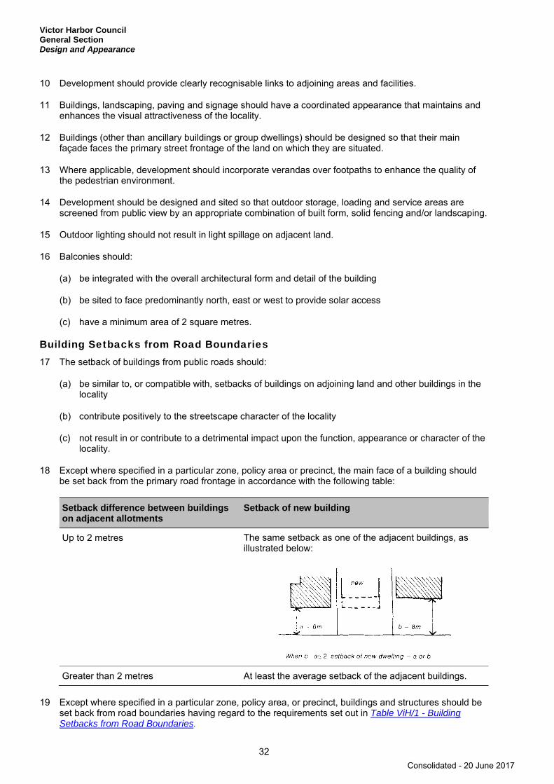
Victor Harbor Council General Section Design and Appearance
32
10 Development should provide clearly recognisable links to adjoining areas and facilities.
11 Buildings, landscaping, paving and signage should have a coordinated appearance that maintains and enhances the visual attractiveness of the locality.
12 Buildings (other than ancillary buildings or group dwellings) should be designed so that their main façade faces the primary street frontage of the land on which they are situated.
13 Where applicable, development should incorporate verandas over footpaths to enhance the quality of the pedestrian environment.
14 Development should be designed and sited so that outdoor storage, loading and service areas are screened from public view by an appropriate combination of built form, solid fencing and/or landscaping.
15 Outdoor lighting should not result in light spillage on adjacent land.
16 Balconies should:
(a) be integrated with the overall architectural form and detail of the building
(b) be sited to face predominantly north, east or west to provide solar access
(c) have a minimum area of 2 square metres.
Building Setbacks from Road Boundaries 17 The setback of buildings from public roads should:
(a) be similar to, or compatible with, setbacks of buildings on adjoining land and other buildings in the locality
(b) contribute positively to the streetscape character of the locality
(c) not result in or contribute to a detrimental impact upon the function, appearance or character of the locality.
18 Except where specified in a particular zone, policy area or precinct, the main face of a building should be set back from the primary road frontage in accordance with the following table:
Setback difference between buildings on adjacent allotments
Setback of new building
Up to 2 metres The same setback as one of the adjacent buildings, as illustrated below:
Greater than 2 metres At least the average setback of the adjacent buildings.
19 Except where specified in a particular zone, policy area, or precinct, buildings and structures should be set back from road boundaries having regard to the requirements set out in Table ViH/1 - Building Setbacks from Road Boundaries.
Consolidated - 20 June 2017

Victor Harbor Council General Section
Design and Appearance
33
20 Except where specified in a zone, policy area or precinct, the setback of development from a secondary street frontage should reflect the setbacks of the adjoining buildings and other buildings in the locality.
21 Non-residential buildings should be setback further than other buildings in the locality where they:
(a) are larger in bulk and height
(b) have external surfaces which are highly reflective
(c) can not be effectively screened by vegetation, natural landforms or existing buildings or structures.
22 Development likely to encroach within a road widening setback under the Metropolitan Adelaide Road Widening Plan Act 1972 should be set back sufficiently from the boundary required for road widening.
Consolidated - 20 June 2017

Victor Harbor Council General Section Energy Efficiency
34
Energy Efficiency
OBJECTIVES
1 Development designed and sited to conserve energy.
2 Development that provides for on-site power generation including photovoltaic cells and wind power.
PRINCIPLES OF DEVELOPMENT CONTROL
1 Development should provide for efficient solar access to buildings and open space all year around.
2 Buildings should be sited and designed:
(a) to ensure adequate natural light and winter sunlight is available to the main activity areas of adjacent buildings
(b) so that open spaces associated with the main activity areas face north for exposure to winter sun.
On-site Energy Generation 3 Development should facilitate the efficient use of photovoltaic cells and solar hot water systems by:
(a) taking into account overshadowing from neighbouring buildings
(b) designing roof orientation and pitches to maximise exposure to direct sunlight, by providing a roof area of at least 10 square metres which faces between 30 degrees and 20 degrees east and west of north respectively and has a pitch greater than 18 degrees.
4 Public infrastructure and lighting, should be designed to generate and use renewable energy.
Consolidated - 20 June 2017
Victor Harbor Council General Section
Forestry
35
Forestry
OBJECTIVES
1 Forestry development that is designed and sited to maximise environmental and economic benefits whilst managing potential negative impacts on the environment, transport networks and surrounding land uses and landscapes.
PRINCIPLES OF DEVELOPMENT CONTROL
1 Forestry plantations should not be undertaken if they will cause or require the clearance of valued trees or substantially intact strata of vegetation, or detrimentally affect the physical environment or scenic quality of the rural landscape.
2 Forestry plantations should not occur:
(a) on land with a slope exceeding 20 degrees
(b) within a separation distance (which may include forestry firebreaks and vehicle access tracks) of 50 metres of either of the following:
(i) any dwelling including those on an adjoining allotment
(ii) a reserve gazetted under the National Parks and Wildlife Act 1972 or Wilderness Protection Act 1992.
3 Forestry plantations should:
(a) not involve cultivation (excluding spot cultivation) in drainage lines or within 20 metres of a major watercourse (a third order or higher watercourse), lake, reservoir, wetland and sinkhole (direct connection to aquifer)
(b) incorporate artificial drainage lines (ie culverts, runoffs and constructed drains) integrated with natural drainage lines to minimise concentrated water flows onto or from plantation areas
(c) retain a minimum 10 metre width separation distance immediately to either side of a watercourse (a first or second order watercourse) and sinkhole (no-direct connection to aquifer). This separation distance should contain locally indigenous vegetation (including grasses) and unmodified topography to ensure water flow.
4 Forestry plantations should incorporate:
(a) 7 metre wide external boundary firebreaks for plantations of 40 hectares or less
(b) 10 metre wide external boundary firebreaks for plantations of between 40 and 100 hectares
(c) 20 metre wide external boundary firebreaks, or 10 metres with an additional 10 metres of fuel-reduced plantation, for plantations of 100 hectares or greater.
5 Forestry plantations should incorporate vehicle access tracks:
(a) within all firebreaks
(b) of a minimum width of 7 metres with a vertical clearance of 4 metres
Consolidated - 20 June 2017
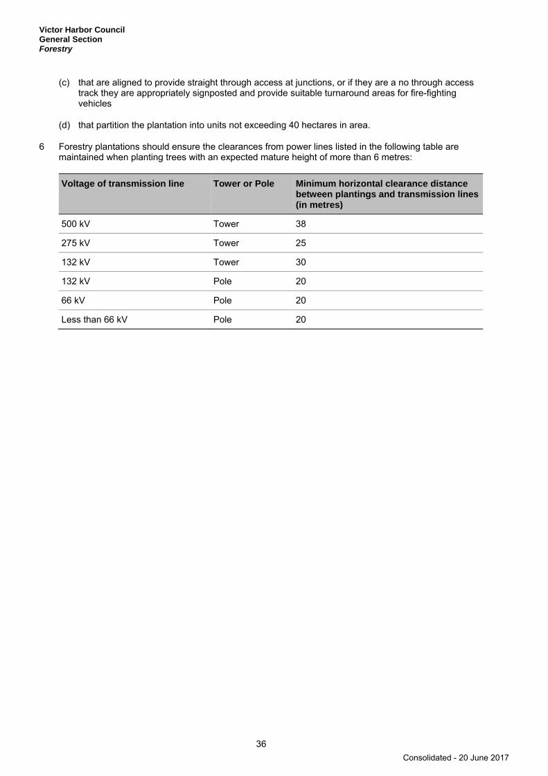
Victor Harbor Council General Section Forestry
36
(c) that are aligned to provide straight through access at junctions, or if they are a no through access track they are appropriately signposted and provide suitable turnaround areas for fire-fighting vehicles
(d) that partition the plantation into units not exceeding 40 hectares in area.
6 Forestry plantations should ensure the clearances from power lines listed in the following table are maintained when planting trees with an expected mature height of more than 6 metres:
Voltage of transmission line Tower or Pole Minimum horizontal clearance distance between plantings and transmission lines (in metres)
500 kV Tower 38
275 kV Tower 25
132 kV Tower 30
132 kV Pole 20
66 kV Pole 20
Less than 66 kV Pole 20
Consolidated - 20 June 2017

Victor Harbor Council General Section
Hazards
37
Hazards
OBJECTIVES
1 Maintenance of the natural environment and systems by limiting development in areas susceptible to natural hazard risk.
2 Development located away from areas that are vulnerable to, and cannot be adequately and effectively protected from the risk of natural hazards.
3 Critical community facilities such as hospitals, emergency control centres, major service infrastructure facilities, and emergency service facilities located where they are not exposed to natural hazard risks.
4 Development located and designed to minimise the risks to safety and property from flooding.
5 Development located to minimise the threat and impact of bushfires on life and property.
6 Expansion of existing non-rural uses directed away from areas of high bushfire risk.
7 The environmental values and ecological health of receiving waterways and marine environments protected from the release of acid water resulting from the disturbance of acid sulphate soils.
8 Protection of human health and the environment wherever site contamination has been identified or is suspected to have occurred.
9 Appropriate assessment and remediation of site contamination to ensure land is suitable for the proposed use and provides a safe and healthy living and working environment.
10 Minimisation of harm to life, property and the environment through appropriate location of development and appropriate storage, containment and handling of hazardous materials.
PRINCIPLES OF DEVELOPMENT CONTROL
1 Development should be excluded from areas that are vulnerable to, and cannot be adequately and effectively protected from, the risk of hazards.
2 There should not be any significant interference with natural processes in order to reduce the exposure of development to the risk of natural hazards.
Flooding 3 Development should not occur on land where the risk of flooding is likely to be harmful to safety or
damage property.
4 Development should not be undertaken in areas liable to inundation by tidal, drainage or flood waters unless the development can achieve all of the following:
(a) it is developed with a public stormwater system capable of catering for a 1-in-100 year average return interval flood event
(b) buildings are designed and constructed to prevent the entry of floodwaters in a 1-in-100 year average return interval flood event.
5 Development, including earthworks associated with development, should not do any of the following:
(a) impede the flow of floodwaters through the land or other surrounding land
Consolidated - 20 June 2017

Victor Harbor Council General Section Hazards
38
(b) increase the potential hazard risk to public safety of persons during a flood event
(c) aggravate the potential for erosion or siltation or lead to the destruction of vegetation during a flood
(d) cause any adverse effect on the floodway function
(e) increase the risk of flooding of other land
(f) obstruct a watercourse.
Bushfire 6 The following bushfire protection principles of development control apply to development of land
identified as General, Medium and High bushfire risk areas as shown on the Bushfire Protection Area BPA Maps - Bushfire Risk.
7 Development in a Bushfire Protection Area should be in accordance with those provisions of the Minister’s Code: Undertaking development in Bushfire Protection Areas that are designated as mandatory for Development Plan Consent purposes.
8 Buildings and structures should be located away from areas that pose an unacceptable bushfire risk as a result of one or more of the following:
(a) vegetation cover comprising trees and/or shrubs
(b) poor access
(c) rugged terrain
(d) inability to provide an adequate building protection zone
(e) inability to provide an adequate supply of water for fire fighting purposes.
9 Residential, tourist accommodation and other habitable buildings should:
(a) be sited on the flatter portion of allotments and avoid steep slopes, especially upper slopes, narrow ridge crests and the tops of narrow gullies, and slopes with a northerly or westerly aspect
(b) be sited in areas with low bushfire hazard vegetation and set back at least 20 metres from existing hazardous vegetation
(c) have a dedicated and accessible water supply available at all times for fire fighting.
10 Extensions to existing buildings, outbuildings and other ancillary structures should be sited and constructed using materials to minimise the threat of fire spread to residential, tourist accommodation and other habitable buildings in the event of bushfire.
11 Buildings and structures should be designed and configured to reduce the impact of bushfire through using simple designs that reduce the potential for trapping burning debris against the building or structure, or between the ground and building floor level in the case of transportable buildings.
12 Land division for residential or tourist accommodation purposes within areas of high bushfire risk should be limited to those areas specifically set aside for these uses.
13 Where land division does occur it should be designed to:
(a) minimise the danger to residents, other occupants of buildings and fire fighting personnel
(b) minimise the extent of damage to buildings and other property during a bushfire
Consolidated - 20 June 2017

Victor Harbor Council General Section
Hazards
39
(c) ensure each allotment contains a suitable building site that is located away from vegetation that would pose an unacceptable risk in the event of bushfire
(d) ensure provision of a fire hazard separation zone isolating residential allotments from areas that pose an unacceptable bushfire risk by containing the allotments within a perimeter road or through other means that achieve an adequate separation.
14 Vehicle access and driveways to properties and public roads created by land division should be designed and constructed to:
(a) facilitate safe and effective operational use for fire fighting and other emergency vehicles and residents
(b) provide for two-way vehicular access between areas of fire risk and the nearest public road.
15 Olive orchards should be located and developed in a manner that minimises their potential to fuel bushfires.
Salinity 16 Development should not increase the potential for, or result in an increase in, soil and water salinity.
17 Preservation, maintenance and restoration of locally indigenous plant species should be encouraged in areas affected by dry land salinity.
18 Irrigated horticulture and pasture should not increase groundwater-induced salinity.
Acid Sulfate Soils 19 Development and activities, including excavation and filling of land, that may lead to the disturbance of
potential or actual acid sulfate soils should be avoided unless such disturbances are managed in a way that effectively avoids the potential for harm or damage to any of the following:
(a) the marine and estuarine environment
(b) natural water bodies and wetlands
(c) agricultural or aquaculture activities
(d) buildings, structures and infrastructure
(e) public health.
20 Development, including primary production, aquaculture activities and infrastructure, should not proceed unless it can be demonstrated that the risk of releasing acid water resulting from the disturbance of acid sulfate soils is minimal.
Site Contamination 21 Development, including land division, should not occur where site contamination has occurred unless
the site has been assessed and remediated as necessary to ensure that it is suitable and safe for the proposed use.
Containment of Chemical and Hazardous Materials 22 Hazardous materials should be stored and contained in a manner that minimises the risk to public
health and safety and the potential for water, land or air contamination.
23 Development that involves the storage and handling of hazardous materials should ensure that these are contained in designated areas that are secure, readily accessible to emergency vehicles, impervious, protected from rain and stormwater intrusion and other measures necessary to prevent:
Consolidated - 20 June 2017
Victor Harbor Council General Section Hazards
40
(a) discharge of polluted water from the site
(b) contamination of land
(c) airborne migration of pollutants
(d) potential interface impacts with sensitive land uses.
Landslip 24 Development, including associated cut and fill activities, should not lead to an increased danger from
land surface instability or to the potential of landslip occurring on the site or on surrounding land.
25 Development on steep slopes should promote the retention and replanting of vegetation as a means of stabilising and reducing the possibility of surface movement or disturbance.
26 Development in areas susceptible to landslip should:
(a) incorporate split level designs to minimise cutting into the slope
(b) ensure that cut and fill and heights of faces are minimised
(c) ensure cut and fill is supported with engineered retaining walls or are battered to appropriate grades
(d) control any erosion that will increase the gradient of the slope and decrease stability
(e) ensure the siting and operation of an effluent drainage field does not contribute to landslip
(f) provide drainage measures to ensure surface stability is not compromised
(g) ensure natural drainage lines are not obstructed.
Consolidated - 20 June 2017

Victor Harbor Council General Section Heritage Places
41
Heritage Places
OBJECTIVES
1 The conservation of State and local heritage places.
2 The continued use, or adaptive re-use of State and local heritage places that supports the conservation of their cultural significance.
3 Conservation of the setting of State and local heritage places.
PRINCIPLES OF DEVELOPMENT CONTROL
1 A heritage place spatially located on Overlay Maps - Heritage and more specifically identified in Table ViH/5 - State Heritage Places or in Table ViH/4 - Local Heritage Places should not be demolished, destroyed or removed, in total or in part, unless either of the following apply:
(a) that portion of the place to be demolished, destroyed or removed is excluded from the extent of the places identified in the Table(s)
(b) the structural condition of the place represents an unacceptable risk to public or private safety and is beyond economic repair.
2 Development of a State or local heritage place should retain those elements contributing to its heritage value, which may include (but not be limited to):
(a) principal elevations
(b) important vistas and views to and from the place
(c) setting and setbacks
(d) building materials
(e) outbuildings and walls
(f) trees and other landscaping elements
(g) access conditions (driveway form/width/material)
(h) architectural treatments
(i) the use of the place.
3 Development of a State or local heritage place should be compatible with the heritage value of the place.
4 Original unpainted plaster, brickwork, stonework, or other masonry of existing State or local heritage places should be preserved, unpainted.
5 New buildings should not be placed or erected between the front street boundary and the façade of existing State or local heritage places.
6 Development that materially affects the context within which the heritage place is situated should be compatible with the heritage place. It is not necessary to replicate historic detailing, however design elements that should be compatible include, but are not limited to:
Consolidated - 20 June 2017

Victor Harbor Council General Section Heritage Places
42
(a) scale and bulk
(b) width of frontage
(c) boundary setback patterns
(d) proportion and composition of design elements such as rooflines, openings, fencing and landscaping
(e) colour and texture of external materials.
7 The introduction of advertisements and signage to a State or local heritage place should:
(a) be placed on discrete elements of its architecture such as parapets and wall panels, below the canopy, or within fascias and infill end panels and windows
(b) not conceal or obstruct historical detailing of the heritage place
(c) not project beyond the silhouette or skyline of the heritage place
(d) not form a dominant element of the place.
8 The division of land adjacent to or containing a State or local heritage place should occur only where it will:
(a) create an allotment pattern that maintains or reinforces the integrity of the heritage place and the character of the surrounding area
(b) create an allotment or allotments of a size and dimension that can accommodate new development that will reinforce and complement the heritage place and the zone or policy area generally
(c) be of a size and dimension that will enable the siting and setback of new buildings from allotment boundaries so that they do not overshadow, dominate, encroach on or otherwise impact on the setting of the heritage place
(d) provide an area for landscaping of a size and dimension that complements the landscape setting of the heritage place and the landscape character of the locality
(e) enable the State or local heritage place to have a curtilage of a size sufficient to protect its setting.
Consolidated - 20 June 2017

Victor Harbor Council General Section
Historic Conservation Area
43
Historic Conservation Area
Refer to the Map Reference Tables for a list of the Overlay Maps - Heritage that relate to this Historic Conservation Area.
OBJECTIVES
1 The conservation of areas of historical significance.
2 Development that promotes, conserves and enhances the cultural significance and historic character of identified places and areas.
3 Development that complements the historic significance of the area.
4 The retention and conservation of places such as land, buildings, structures and landscape elements that contribute positively to the historic character of the area.
PRINCIPLES OF DEVELOPMENT CONTROL
1 Buildings and structures should not be demolished in whole or in part, unless they are:
(a) structurally unsafe and/or unsound and cannot reasonably be rehabilitated
(b) inconsistent with the desired character for the Historic Conservation Area
(c) associated with a proposed development that supports the desired character for the Historic Conservation Area.
2 Development should take design cues from the existing historic built forms. In doing this, it is not necessary to replicate historic detailing; however design elements for consideration should be compatible with building and streetscape character and should include but not be limited to:
(a) scale and bulk
(b) width of frontage
(c) boundary setback patterns
(d) proportion and composition of design elements such as roof lines, pitches, openings, verandas, fencing and landscaping
(e) colour and texture of external materials
(f) visual interest.
3 The conversion of an existing dwelling into two or more dwellings may be undertaken provided that the building and front yard retain the original external appearance to the public road.
4 Second storey additions to single storey dwellings should achieve one or more of the following:
(a) a sympathetic two-storey addition that uses existing roof space or incorporates minor extensions to the roof space at the rear of the dwelling
Consolidated - 20 June 2017
Victor Harbor Council General Section Historic Conservation Area
44
(b) a second storey within the roof space, where the overall building height, scale and form is compatible with existing single-storey development in the policy area
(c) second storey windows having a total length less than 30 per cent of the total roof length along each elevation.
5 Front fences and gates should:
(a) reflect and conserve the traditional period, style and form of the associated building
(b) generally be of low timber pickets, low pier and plinth masonry, wrought iron, brush or masonry
(c) be no more than 1.2 metres in height.
6 Rear and side boundary fences located behind the front dwelling alignment should be no more than 1.8 metres in height.
7 Advertisements and/or advertising hoardings associated with places and areas of heritage significance should:
(a) be of a size, colour, shape and materials that enhances the character of the locality
(b) not dominate or detract from the prominence of any place and/or area of historic significance.
8 Development should respect the existing topography and the relationship of sites to street levels and to adjoining land and not involve substantial cut and/or fill or sites.
9 The division of land should occur only where it will maintain the traditional pattern and scale of allotments.
Consolidated - 20 June 2017

Victor Harbor Council General Section
Industrial Development
45
Industrial Development
OBJECTIVES
1 Industrial, warehouse, storage and transport distribution development on appropriately located land, integrated with transport networks and designed to minimise potential impact on these networks.
2 The development of small scale agricultural industries, wineries, mineral water extraction and processing plants, and home based industries in rural areas.
3 Industrially zoned allotments and uses protected from encroachment by adjoining uses that would reduce industrial development or expansion.
4 Industrial development occurring without adverse effects on the health and amenity of occupiers of land in adjoining zones.
5 Compatibility between industrial uses within industrial zones.
6 The improved amenity of industrial areas.
7 Co-location of industries in townships to enable promotion and implementation of innovative waste recovery practices, methods of power generation and reuse of by-products.
PRINCIPLES OF DEVELOPMENT CONTROL
1 Offices and showrooms associated with industrial, warehouse, storage and transport development should be sited at the front of the building with direct and convenient pedestrian access from the main visitor parking area.
2 Any building or structure on, or abutting the boundary of, a non-industrial zone should be restricted to a height of 3 metres above ground level at the boundary and a plane projected at 31 degrees above the horizontal into the development site from that 3 metre height, as shown in the following diagram:
3 Industrial development should enable all vehicles to enter and exit the site in a forward direction.
4 Industrial development abutting an arterial road, a non-industrial zone boundary, or significant open space should be developed in a manner that does not create adverse visual impacts on the locality.
Industrial building orstructure to becontained within thisenvelope
Groundlevel
ZoneBoundary
3 metres
Non-industrialZone
31°
Consolidated - 20 June 2017
Victor Harbor Council General Section Industrial Development
46
5 Building facades facing a non-industrial zone, public road, or public open space should:
(a) use a variety of building finishes
(b) not consist solely of metal cladding
(c) contain materials of low reflectivity
(d) incorporate design elements to add visual interest
(e) avoid large expanses of blank walls.
6 Industrial development should minimise significant adverse impact on adjoining uses due to hours of operation, traffic, noise, fumes, smell, dust, paint or other chemical over-spray, vibration, glare or light spill, electronic interference, ash or other harmful or nuisance-creating impacts.
7 Landscaping should be incorporated as an integral element of industrial development along non-industrial zone boundaries.
8 Fencing (including colour-coated wire mesh fencing) adjacent to public roads should be set back in one of the following ways:
(a) in line with the building facade
(b) behind the building line
(c) behind a landscaped area that softens its visual impact.
9 Marine aquaculture onshore storage, cooling and processing facilities should not impair the coastline and its visual amenity and should:
(a) be sited, designed, landscaped and developed at a scale and using external materials that minimise any adverse visual impact on the coastal landscape
(b) be sited and designed with appropriate vehicular access arrangement
(c) include appropriate waste treatment and disposal.
Small-scale agricultural industries, home-based industries, mineral water extraction and processing plants, and wineries in rural areas 10 Agricultural industries, home based industries, mineral water extraction and processing plants, and
wineries in rural areas should:
(a) use existing buildings and, in particular, buildings of heritage value, in preference to constructing new buildings
(b) (except for wineries in the Mount Lofty Ranges Watershed Protection Zone) be set back at least 50 metres from:
(i) any bore, well or watercourse, where a watercourse is identified as a blue line on a current series 1:50 000 government standard topographic map
(ii) a dam or reservoir that collects water flowing in a watercourse
(iii) a lake or wetland through which water flows
(iv) a channel into which water has been diverted
(v) a known spring
Consolidated - 20 June 2017
Victor Harbor Council General Section
Industrial Development
47
(vi) sink hole
(c) be located within the boundary of a single allotment, including any ancillary uses
(d) not result in more than one industry located on an allotment
(e) include a sign that facilitates access to the site that is sited and designed to complement the features of the surrounding area and which:
(i) does not exceed 2 square metres in area
(ii) is limited to one sign per establishment (for agricultural and home-based industries)
(iii) is not internally illuminated.
11 Agricultural industries, home-based industries, mineral water extraction and processing plants, and wineries in rural areas should not:
(a) necessitate significant upgrading of public infrastructure including roads and other utilities
(b) generate traffic beyond the capacity of roads necessary to service the development
(c) result in traffic and/or traffic volumes that would be likely to adversely alter the character and amenity of the locality
(d) be located on land with a slope greater than 20 per cent (1-in-5).
12 Agricultural industries (except for wineries) in rural areas should be small scale, and:
(a) should include at least one of the following activities normally associated with the processing of primary produce:
(i) washing
(ii) grading
(iii) processing (including bottling)
(iv) packing or storage
(b) may include an associated ancillary area for the sale and/or promotion of produce (including display areas)
(c) should have a total combined area for one or any combination of these activities (including ancillary sales area) not exceeding 250 square metres per allotment, with a maximum building area of 150 square metres, including a maximum area of 50 square metres for ancillary sale and display of goods manufactured in the industry
(d) should process primary produce that is grown within the Mount Lofty Ranges Region
(e) should occur only on an allotment where a habitable dwelling exists.
13 Agricultural industries, wineries (except wineries in the Watershed Protection (Mount Lofty Ranges) Zone) and mineral water extraction and processing plants should not be located:
(a) on land that is classified as being poorly drained or very poorly drained
(b) within 800 metres of a high water level of a public water supply reservoir
Consolidated - 20 June 2017

Victor Harbor Council General Section Industrial Development
48
(c) closer than 300 metres (other than a home based industry) to a dwelling or tourist accommodation that is not in the ownership of the applicant.
14 Home-based industries in rural areas:
(a) should include at least one of the following activities:
(i) arts
(ii) crafts
(iii) tourist
(iv) heritage related activities
(b) may include an ancillary area for the sale or promotion of goods manufactured in the industry (including display areas)
(c) should have a total combined area for one or any combination of these activities (including ancillary sales/promotion area) not exceeding 80 square metres per allotment with a maximum building area of 80 square metres, including a maximum area of 30 square metres for sale of goods made on the allotment by the industry
(d) should not be located further than 50 metres from a habitable dwelling occupied by the proprietor of the industry on the allotment.
15 Mineral water extraction and processing plants in rural areas:
(a) should include at least one of the following activities normally associated with the extraction and processing of mineral water:
(i) extraction
(ii) bottling
(iii) packaging
(iv) storage
(v) distribution
(b) may include ancillary activities of administration and sale and/or promotion of mineral water product
(c) should have a total combined area for one or any combination of these activities (including ancillary sale and/or promotion areas) not exceeding 350 square metres (or 450 square metres in the Watershed Protection (Mount Lofty Ranges) Zone) per allotment with a maximum building area of 250 square metres, including a maximum area of 50 square metres for ancillary sale and/or promotion of mineral water product.
16 Wineries in rural areas should:
(a) include at least one of the following activities normally associated with the making of wine:
(i) crushing
(ii) fermenting
(iii) bottling
Consolidated - 20 June 2017

Victor Harbor Council General Section
Industrial Development
49
(iv) maturation/cellaring of wine
(v) ancillary activities of administration, sale and/or promotion of wine product and restaurant
(b) be located within the boundary of a single allotment which adjoins or is on the same allotment as a vineyard
(c) process primary produce that is primarily sourced within the Mount Lofty Ranges Region
(d) only include a restaurant as an ancillary use to the winery
(e) be located not closer than 300 metres to a dwelling or tourist accommodation (that is not in the ownership of the winery applicant) where the crush capacity is equal to or greater than 500 tonnes per annum.
Consolidated - 20 June 2017
Victor Harbor Council General Section Infrastructure
50
Infrastructure
OBJECTIVES
1 Infrastructure provided in an economical and environmentally sensitive manner.
2 Infrastructure, including social infrastructure, provided in advance of need.
3 Suitable land for infrastructure identified and set aside in advance of need.
4 The visual impact of infrastructure facilities minimised.
5 The efficient and cost-effective use of existing infrastructure.
PRINCIPLES OF DEVELOPMENT CONTROL
1 Development should not occur without the provision of adequate utilities and services, including:
(a) electricity supply
(b) water supply
(c) drainage and stormwater systems
(d) waste disposal
(e) effluent disposal systems
(f) formed all-weather public roads
(g) telecommunications services
(h) social infrastructure, community services and facilities
(i) gas services.
2 Development should incorporate any relevant and appropriate social infrastructure, community services and facilities.
3 Development should only occur where it provides, or has access to, relevant easements for the supply of infrastructure.
4 Development should incorporate provision for the supply of infrastructure services to be located within common service trenches where practicable.
5 Development should not occur until adequate and coordinated drainage of the land is provided.
6 Development in urban areas should not occur without provision of an adequate reticulated domestic quality mains water supply and an appropriate waste treatment system.
7 In areas where no reticulated water supply is available, buildings whose usage is reliant on a water supply should be equipped with an adequate and reliable on-site water storage system.
8 Urban development should have a direct water supply.
Consolidated - 20 June 2017

Victor Harbor Council General Section
Infrastructure
51
9 Electricity infrastructure should be designed and located to minimise visual and environmental impacts.
10 Utilities and services, including access roads and tracks, should be sited on areas already cleared of native vegetation. If this is not possible, their siting should cause minimal interference or disturbance to existing native vegetation and biodiversity.
11 Utility buildings and structures should be grouped with non-residential development, where possible.
12 Development in proximity to infrastructure facilities should be sited and be of a scale to ensure adequate separation to protect people and property.
13 Incompatible uses should not encroach upon the easements of infrastructure corridors for existing and proposed transmission lines.
14 In urban areas, electricity supply (except transmission lines) serving new development should be installed underground, excluding lines having a capacity greater than or equal to 33kV.
15 Provision should be made for new transmission and distribution substations and overhead major electricity line corridors (having a capacity greater than or equal to 33kV) in areas which have the required buffer distance to protect people and allow for adequate access.
16 Land division for the purpose of residential and other sensitive land uses should not occur within electricity line corridors or existing electricity easements unless the resultant allotments are large enough to enable accommodation of safe clearances and expected structures.
Consolidated - 20 June 2017

Victor Harbor Council General Section Interface between Land Uses
52
Interface between Land Uses
OBJECTIVES
1 Development located and designed to minimise adverse impact and conflict between land uses.
2 Protect community health and amenity from adverse impacts of development.
3 Protect desired land uses from the encroachment of incompatible development.
PRINCIPLES OF DEVELOPMENT CONTROL
1 Development should not detrimentally affect the amenity of the locality or cause unreasonable interference through any of the following:
(a) the emission of effluent, odour, smoke, fumes, dust or other airborne pollutants
(b) noise
(c) vibration
(d) electrical interference
(e) light spill
(f) glare
(g) hours of operation
(h) traffic impacts.
2 Development should be sited and designed to minimise negative impact on existing and potential future land uses desired in the locality.
3 Development adjacent to a Residential Zone should be designed to minimise overlooking and overshadowing of adjacent dwellings and private open space.
4 Residential development adjacent to non-residential zones and land uses should be located, designed and/or sited to protect residents from potential adverse impacts from non-residential activities.
5 Sensitive uses likely to conflict with the continuation of lawfully existing developments and land uses desired for the zone should be designed to minimise negative impacts.
6 Non-residential development on land abutting a residential zone should be designed to minimise noise impacts to achieve adequate levels of compatibility between existing and proposed uses.
Noise Generating Activities 7 Development that emits noise (other than music noise) should include noise attenuation measures that
achieve the relevant Environment Protection (Noise) Policy criteria when assessed at the nearest existing noise sensitive premises.
8 Development with the potential to emit significant noise (e.g. industry) should incorporate noise attenuation measures that prevent noise from causing unreasonable interference with the amenity of noise sensitive premises.
Consolidated - 20 June 2017

Victor Harbor Council General Section
Interface between Land Uses
53
9 Outdoor areas (such as beer gardens or dining areas) associated with licensed premises should be designed or sited to minimise adverse noise impacts on adjacent existing or future noise sensitive development.
10 Development proposing music should include noise attenuation measures that achieve the following desired noise levels:
Noise level assessment location Desired noise level
Adjacent existing noise sensitive development property boundary
Less than 8 dB above the level of background noise (L90,15min) in any octave band of the sound spectrum
and
Less than 5 dB(A) above the level of background noise (LA90,15min) for the overall (sum of all octave bands) A-weighted level
Adjacent land property boundary Less than 65dB(Lin) at 63Hz and 70dB(Lin) in all other octave bands of the sound spectrum
or
Less than 8 dB above the level of background noise (L90,15min) in any octave band of the sound spectrum and 5 dB(A) overall (sum of all octave bands) A-weighted level
Air Quality 11 Development with the potential to emit harmful or nuisance-generating air pollution should incorporate
air pollution control measures to prevent harm to human health or unreasonable interference with the amenity of sensitive uses within the locality.
12 Chimneys or exhaust flues associated with commercial development (including cafes, restaurants and fast food outlets) should be designed to ensure they do not cause a nuisance or health concerns to nearby sensitive receivers by:
(a) incorporating appropriate treatment technology before exhaust emissions are released to the atmosphere
(b) ensuring that the location and design of chimneys or exhaust flues maximises dispersion and takes into account the location of nearby sensitive uses.
Rural Interface 13 The potential for adverse impacts resulting from rural development should be minimised by:
(a) not locating horticulture or intensive animal keeping on land adjacent to townships
(b) maintaining an adequate separation between horticulture or intensive animal keeping and townships, other sensitive uses and, where desirable, other forms of primary production.
14 Traffic movement, spray drift, dust, noise, odour, and the use of frost fans and gas guns associated with primary production activities should not lead to unreasonable impact on adjacent land users.
15 Existing primary production uses and mineral extraction should not be prejudiced by the inappropriate encroachment of sensitive uses such as urban development.
16 Development that is adjacent to land used for primary production (within either the zone or adjacent zones) should include appropriate setbacks and vegetative plantings designed to minimise the potential impacts of chemical spray drift and other impacts associated with primary production.
Consolidated - 20 June 2017

Victor Harbor Council General Section Interface between Land Uses
54
17 New urban development should provide a buffer of at least 40 metres wide (inclusive of any fuel break, emergency vehicle access or road) separating urban and rural activities.
18 Development within 300 metres of facilities for the handling, transportation and storage of bulk commodities should:
(a) not prejudice the continued operation of those facilities
(b) be located, designed, and developed having regard to the potential environmental impact arising from the operation of such facilities and the potential extended operation of activities.
Consolidated - 20 June 2017

Victor Harbor Council General Section
Land Division
55
Land Division
OBJECTIVES
1 Land division that occurs in an orderly sequence allowing efficient provision of new infrastructure and facilities and making optimum use of existing under utilised infrastructure and facilities.
2 Land division that creates allotments appropriate for the intended use.
3 Land division layout that is optimal for energy efficient building orientation.
4 Land division that is integrated with site features, including landscape and environmental features, adjacent land uses, the existing transport network and the availability of infrastructure.
5 Land division restricted in rural areas to ensure the efficient use of rural land for primary production and avoidance of uneconomic infrastructure provision.
PRINCIPLES OF DEVELOPMENT CONTROL
1 When land is divided:
(a) stormwater should be capable of being drained safely and efficiently from each proposed allotment and disposed of from the land in an environmentally sensitive manner
(b) a sufficient water supply should be made available for each allotment
(c) provision should be made for the disposal of wastewater, sewage and other effluent from each allotment without risk to health
(d) proposed roads should be graded, or be capable of being graded to connect safely and conveniently with an existing road or thoroughfare.
2 Land should not be divided if any of the following apply:
(a) the size, shape, location, slope or nature of the land makes any of the allotments unsuitable for the intended use
(b) any allotment will not have a frontage to one of the following:
(i) an existing road
(ii) a proposed public road
(iii) access to a public road via an internal roadway in a plan of community division
(c) the intended use of the land is likely to require excessive cut and/or fill
(d) it is likely to lead to undue erosion of the subject land or land within the locality
(e) the wastewater treatment plant to which subsequent development will be connected does not have sufficient capacity to handle the additional wastewater volumes and pollutant loads generated by such development
(f) the area is unsewered and cannot accommodate an appropriate onsite wastewater disposal system within the allotment that complies with (or can comply with) the relevant public and environmental health legislation applying to the intended use(s)
Consolidated - 20 June 2017
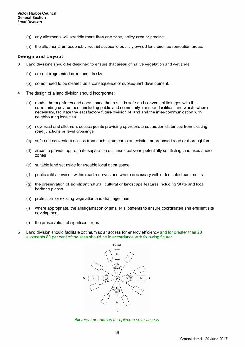
Victor Harbor Council General Section Land Division
56
(g) any allotments will straddle more than one zone, policy area or precinct
(h) the allotments unreasonably restrict access to publicly owned land such as recreation areas.
Design and Layout 3 Land divisions should be designed to ensure that areas of native vegetation and wetlands:
(a) are not fragmented or reduced in size
(b) do not need to be cleared as a consequence of subsequent development.
4 The design of a land division should incorporate:
(a) roads, thoroughfares and open space that result in safe and convenient linkages with the surrounding environment, including public and community transport facilities, and which, where necessary, facilitate the satisfactory future division of land and the inter-communication with neighbouring localities
(b) new road and allotment access points providing appropriate separation distances from existing road junctions or level crossings
(c) safe and convenient access from each allotment to an existing or proposed road or thoroughfare
(d) areas to provide appropriate separation distances between potentially conflicting land uses and/or zones
(e) suitable land set aside for useable local open space
(f) public utility services within road reserves and where necessary within dedicated easements
(g) the preservation of significant natural, cultural or landscape features including State and local heritage places
(h) protection for existing vegetation and drainage lines
(i) where appropriate, the amalgamation of smaller allotments to ensure coordinated and efficient site development
(j) the preservation of significant trees.
5 Land division should facilitate optimum solar access for energy efficiency and for greater than 20 allotments 80 per cent of the sites should be in accordance with following figure:
Allotment orientation for optimum solar access
Consolidated - 20 June 2017
Victor Harbor Council General Section
Land Division
57
6 Land division should result in allotments of a size suitable for their intended use.
7 Allotments in the form of a battleaxe configuration should:
(a) have an area in accordance with the site area parameters for the zone or policy area (excluding the area of the ‘handle’ of such an allotment)
(b) provide for an access onto a public road, with the driveway ‘handle’ being not less than 5 metres in width nor more than 25 metres in length
(c) contain sufficient area on the allotment for a vehicle to turn around to enable it to egress the allotment in a forward direction
(d) not be created where it would lead to multiple access points onto a road which would dominate or adversely affect the amenity of the streetscape
(e) be avoided where their creation would be incompatible with the prevailing pattern of development.
8 Allotments should have an orientation, size and configuration to encourage development that:
(a) minimises the need for earthworks and retaining walls
(b) maintains natural drainage systems
(c) faces abutting streets and open spaces
(d) does not require the removal of native vegetation to facilitate that development
(e) will not overshadow, dominate, encroach on or otherwise detrimentally affect the setting of the surrounding locality.
9 Within defined townships and settlements where the land to be divided borders a river, lake, wetland or creek, the land adjoining the bank should become public open space and linked with an existing or proposed pedestrian or transport network.
10 Within defined townships and settlements land division should make provision for a reserve or an area of open space that is at least 25 metres wide from the top of the bank of a watercourse and that incorporates land within the 1-in-100 year average return interval flood event area.
11 The layout of a land division should keep flood-prone land free from development.
12 The arrangement of roads, allotments, reserves and open space should enable the provision of a stormwater management drainage system that:
(a) contains and retains all watercourses, drainage lines and native vegetation
(b) enhances amenity
(c) integrates with the open space system and surrounding area.
13 Land division should allow for the incorporation of treatment systems which enable the reuse of ‘grey water’ for the flushing of toilets and watering of gardens. Grey water is wastewater generated from bathrooms (showers, baths, spas and hand basins) and laundries (washing machines and troughs), but does not include wastewater from kitchens which has the potential to cause unpleasant odour.
Consolidated - 20 June 2017

Victor Harbor Council General Section Land Division
58
Roads and Access 14 Road reserves should be of a width and alignment that can:
(a) provide for safe and convenient movement and parking of projected volumes of vehicles and other users
(b) provide for footpaths, cycle lanes and shared-use paths for the safety and convenience of residents and visitors
(c) allow vehicles to enter or reverse from an allotment or site in a single movement allowing for a car parked on the opposite side of the street
(d) accommodate street tree planting, landscaping and street furniture
(e) accommodate the location, construction and maintenance of stormwater drainage and public utilities
(f) provide unobstructed, safe and efficient vehicular access to individual allotments and sites
(g) allow for the efficient movement of service and emergency vehicles.
15 Two way carriageways should accommodate minimum carriageway widths of:
(a) 7 metres and a minimum road reserve of 15 metres where the projected traffic volume is up to 2000 vehicles per day
(b) 8 metres and a minimum road reserve of 18 metres where the projected traffic volume is greater than 2000 vehicles per day and no more than 3000 vehicles per day
(c) 8 metres and a minimum road reserve of 20 metres where the projected traffic volume is greater than 3000 vehicles per day.
16 The design of the land division should facilitate the most direct route to local facilities for pedestrians and cyclists and enable footpaths, cycle lanes and shared-use paths to be provided of a safe and suitable width and reasonable longitudinal gradient.
17 The design of the road reserve should facilitate footpaths that are:
(a) located on one side of the road reserve, where the traffic volumes is up to 2000 vehicles per day
(b) located on both sides of the road reserve where the traffic volumes are greater than 2000 vehicles per day
(c) at least 1.5 metres wide with a maximum longitudinal grade of 12 per cent and cross fall of 2.5 per cent
(d) constructed of exposed aggregate concrete that is able to withstand construction loads.
18 The layout of land divisions should result in roads designed and constructed to ensure:
(a) that traffic speeds and volumes are restricted where appropriate by limiting street length and/or the distance between bends and slow points
(b) there are adequate sight distances for motorists at intersections, junctions, pedestrian and cyclist crossings, and crossovers to allotments to ensure the safety of all road users and pedestrians
(c) that existing dedicated cycling and walking routes are not compromised.
Consolidated - 20 June 2017

Victor Harbor Council General Section
Land Division
59
19 The design of the land division should provide space sufficient for on-street visitor car parking for the number and size of allotments, taking account of:
(a) the size of proposed allotments and sites and opportunities for on-site parking
(b) the availability and frequency of public and community transport
(c) on-street parking demand likely to be generated by nearby uses.
20 A minimum of one on street car park should be provided for every two allotments created.
21 The layout of land divisions should incorporate street patterns designed to enhance the efficient movement of traffic and minimise trip lengths.
Land Division in Rural Areas 22 Rural land should not be divided if the resulting allotments would be of a size and configuration likely to
impede the efficient use of rural land for any of the following:
(a) primary production
(b) value adding industries related to primary production
(c) protection of natural resources.
23 Rural land should not be divided where new allotments would result in any of the following:
(a) fragmentation of productive primary production land
(b) strip development along roads or water mains
(c) prejudice against the proper and orderly development of townships
(d) removal of native vegetation for allotment boundaries, access roads, infrastructure, dwellings and other buildings or firebreaks
(e) uneconomic costs to the community for the provision of services.
Consolidated - 20 June 2017

Victor Harbor Council General Section Landscaping, Fences and Walls
60
Landscaping, Fences and Walls
OBJECTIVES
1 The amenity of land and development enhanced with appropriate planting and other landscaping works, using locally indigenous plant species where possible.
2 Functional fences and walls that enhance the attractiveness of development.
PRINCIPLES OF DEVELOPMENT CONTROL
1 Development should incorporate open space and landscaping and minimise hard paved surfaces in order to:
(a) complement built form and reduce the visual impact of larger buildings (eg taller and broader plantings against taller and bulkier building components)
(b) enhance the appearance of road frontages
(c) screen service yards, loading areas and outdoor storage areas
(d) minimise maintenance and watering requirements
(e) enhance and define outdoor spaces, including car parking areas
(f) maximise shade and shelter
(g) assist in climate control within and around buildings
(h) minimise heat absorption and reflection
(i) maintain privacy
(j) maximise stormwater re-use
(k) complement existing vegetation, including native vegetation
(l) contribute to the viability of ecosystems and species
(m) promote water and biodiversity conservation.
2 Landscaping should:
(a) include the planting of locally indigenous species where appropriate
(b) be oriented towards the street frontage
(c) result in the appropriate clearance from powerlines and other infrastructure being maintained.
3 Landscaping should not:
(a) unreasonably restrict solar access to adjoining development
(b) cause damage to buildings, paths and other landscaping from root invasion, soil disturbance or plant overcrowding
Consolidated - 20 June 2017

Victor Harbor Council General Section
Landscaping, Fences and Walls
61
(c) introduce pest plants
(d) increase the risk of bushfire
(e) remove opportunities for passive surveillance
(f) increase leaf fall in watercourses
(g) increase the risk of weed invasion
(h) obscure driver sight lines
(i) create a hazard for train or tram drivers by obscuring sight lines at crossovers.
4 Fences and walls, including retaining walls, should:
(a) not result in damage to neighbouring trees
(b) be compatible with the associated development and with existing predominant, attractive fences and walls in the locality
(c) enable some visibility of buildings from and to the street to enhance safety and allow casual surveillance
(d) incorporate articulation or other detailing where there is a large expanse of wall facing the street
(e) assist in highlighting building entrances
(f) be sited and limited in height, to ensure adequate sight lines for motorists and pedestrians especially on corner sites
(g) in the case of side and rear boundaries, be of sufficient height to maintain privacy and/or security without adversely affecting the visual amenity or access to sunlight of adjoining land
(h) be constructed of non-flammable materials.
5 Front fencing should be open in form to allow cross ventilation and access to sunlight.
Consolidated - 20 June 2017
Victor Harbor Council General Section Marinas and Maritime Structures
62
Marinas and Maritime Structures
OBJECTIVE
1 The provision, in appropriate locations, of marinas, pontoons, jetties, piers, wharves and boat moorings that cater for vessels and:
(a) maintain public access to the waterfront
(b) do not compromise public safety
(c) preserve the structural integrity of the marine infrastructure
(d) minimise adverse impacts on the natural environment.
PRINCIPLES OF DEVELOPMENT CONTROL
1 Marina development should include one or more of the following:
(a) wet and dry berthing of boats
(b) launching and retrieval of recreational boats and associated trailer and car parking areas
(c) access ramps, landings, storage and other structures associated with a marina
(d) clubrooms for maritime organisations.
2 The design of marinas, berths, channels, fairways, gangways and floating structures should comply with:
(a) Australian Standard AS 3962: Guidelines for Design of Marinas
(b) Australian Standard AS 4997: Guidelines for the Design of Maritime Structures.
3 Development should not obstruct or impair:
(a) navigation and access channels
(b) maintenance activities of marine infrastructure including revetment walls
(c) the operation of wharves.
4 Safe public access should be provided or maintained to:
(a) the waterfront
(b) known diving areas
(c) jetties, wharves and associated activities.
5 Marinas should be designed to:
(a) facilitate water circulation and exchange
(b) maximise the penetration of sunlight into the water.
Consolidated - 20 June 2017
Victor Harbor Council General Section
Mineral Extraction
63
Mineral Extraction
OBJECTIVES
1 Development of mining activities in a way that contributes to the sustainable growth of the industry.
2 Protection of mineral deposits against intrusion by inappropriate forms of development.
3 Areas with scenic or conservation significance protected from undue damage arising from mining operations.
4 Mining operations undertaken with minimal adverse impacts on the environment and on the health and amenity of adjacent land uses.
5 Minimisation of the impacts from mining activities upon the existing groundwater level and the quality of groundwater resources.
6 Mining operations that make adequate provision for site rehabilitation.
PRINCIPLES OF DEVELOPMENT CONTROL
1 Known reserves of economically-viable mineral deposits should be kept free of development that may inhibit their future exploitation.
2 Development in proximity to mining operations should not be undertaken where it may be exposed to adverse impacts resulting from mining activities.
3 Mining in scenic and native vegetation areas should only be undertaken if:
(a) the proposed location is the best site in regard to minimising loss of amenity, degradation of the landscape and loss of native vegetation
(b) there are a limited number of known reserves of the minerals in the area or elsewhere in the State
(c) the extraction and transportation of materials from alternative sites to principal centres of consumption carry significantly higher costs
(d) the site is capable of restoration with locally indigenous plant species to counter the long-term impact on the landscape and biodiversity.
4 Stormwater and/or wastewater from land used for mining should be diverted into a silt retention structure so that it can be reused on-site for purposes such as truck wash-down, dust control, washing of equipment and landscape irrigation or for disposal off-site in an environmentally responsible manner.
5 Access to land used for mining should be sited and designed to accommodate heavy-vehicle traffic and ensure the safety of all road users.
6 Mining operations should:
(a) ensure that minimal damage is caused to the landscape
(b) minimise the area required for operations, and provide for the progressive reclamation of disturbed areas
(c) minimise disturbance to natural hydrological systems.
Consolidated - 20 June 2017
Victor Harbor Council General Section Mineral Extraction
64
Separation Treatments, Buffers and Landscaping 7 Mining development should be sited, designed and sequenced to protect the amenity of surrounding
land uses from environmental nuisance such as dust or vibration emanating from mining operations.
8 Mining operations that are likely to impact upon the amenity of the locality should incorporate a separation distance and/or mounding/vegetation between the mining operations (including stockpiles) and adjoining allotments to help minimise exposure to those potential impacts.
9 Quarry faces should be orientated away from public view.
10 Screening of mining areas should occur in advance of extraction commencing.
11 An area of densely vegetated and/or mounded land should be established around the perimeter of mining sites in order to screen excavated land and mineral processing facilities from all of the following:
(a) residential areas
(b) tourist areas
(c) tourist routes
(d) scenic routes.
12 Screen planting around mining operations should incorporate a mixture of trees and shrubs that:
(a) contribute to an attractive landscape
(b) suit local soil and climatic conditions
(c) are fast growing and/or have a long life expectancy
(d) are locally indigenous species.
13 Borrow pits for road making materials should be sited so as to cause the minimum effect on their surroundings.
Consolidated - 20 June 2017
Victor Harbor Council General Section
Natural Resources
65
Natural Resources
OBJECTIVES
1 Retention, protection and restoration of the natural resources and environment.
2 Protection of the quality and quantity of South Australia’s surface waters, including inland, marine and estuarine and underground waters.
3 The ecologically sustainable use of natural resources including water resources, including marine waters ground water, surface water and watercourses.
4 Natural hydrological systems and environmental flows reinstated, and maintained and enhanced.
5 Development consistent with the principles of water sensitive design.
6 Development sited and designed to:
(a) protect natural ecological systems
(b) achieve the sustainable use of water
(c) protect water quality, including receiving waters
(d) reduce runoff and peak flows and prevent the risk of downstream flooding
(e) minimise demand on reticulated water supplies
(f) maximise the harvest and use of stormwater
(g) protect stormwater from pollution sources.
7 Storage and use of stormwater which avoids adverse impact on public health and safety.
8 Native flora, fauna and ecosystems protected, retained, conserved and restored.
9 Restoration, expansion and linking of existing native vegetation to facilitate habitat corridors for ease of movement of fauna.
10 Minimal disturbance and modification of the natural landform.
11 Protection of the physical, chemical and biological quality of soil resources.
12 Protection of areas prone to erosion or other land degradation processes from inappropriate development.
13 Protection of the scenic qualities of natural and rural landscapes.
PRINCIPLES OF DEVELOPMENT CONTROL
1 Development should be undertaken with minimum impact on the natural environment, including air and water quality, land, soil, biodiversity, and scenically attractive areas.
2 Development should ensure that South Australia’s natural assets, such as biodiversity, water and soil, are protected and enhanced.
Consolidated - 20 June 2017
Victor Harbor Council General Section Natural Resources
66
3 Development should not significantly obstruct or adversely affect sensitive ecological areas such as creeks, wetlands, estuaries and significant seagrass and mangrove communities.
4 Development should be appropriate to land capability and the protection and conservation of water resources and biodiversity.
5 Development located within any of the following areas should not adversely affect the quality or quantity of water resources:
(a) ‘River Murray Protection Area - Tributaries Area’ designated on Concept Plan Map ViH/1(A) - Development Constraints - Water Management Areas
(b) ‘Mount Lofty Ranges Water Protection Area’ designated on Concept Plan Map ViH/1(B) - Development Constraints - Water Management Areas
(c) ‘Prescribed Water Resource Areas’ designated on Concept Plan Map ViH/1(B) - Development Constraints - Water Management Areas.
Water Sensitive Design 6 Development should be designed to maximise conservation, minimise consumption and encourage re-
use of water resources.
7 Development should not take place if it results in unsustainable use of surface or underground water resources.
8 Development should be sited and designed to:
(a) capture and re-use stormwater, where practical
(b) minimise surface water runoff
(c) prevent soil erosion and water pollution
(d) protect and enhance natural water flows
(e) protect water quality by providing adequate separation distances from watercourses and other water bodies
(f) not contribute to an increase in salinity levels
(g) avoid the water logging of soil or the release of toxic elements
(h) maintain natural hydrological systems and not adversely affect:
(i) the quantity and quality of groundwater
(ii) the depth and directional flow of groundwater
(iii) the quality and function of natural springs.
9 Water discharged from a development site should:
(a) be of a physical, chemical and biological condition equivalent to or better than its pre-developed state
(b) not exceed the rate of discharge from the site as it existed in pre-development conditions.
10 Development should include stormwater management systems to protect it from damage during a minimum of a 1-in-100 year average return interval flood.
Consolidated - 20 June 2017
Victor Harbor Council General Section
Natural Resources
67
11 Development should have adequate provision to control any stormwater over-flow runoff from the site and should be sited and designed to improve the quality of stormwater and minimise pollutant transfer to receiving waters.
12 Development should include stormwater management systems to mitigate peak flows and manage the rate and duration of stormwater discharges from the site to ensure the carrying capacities of downstream systems are not overloaded.
13 Development should include stormwater management systems to minimise the discharge of sediment, suspended solids, organic matter, nutrients, bacteria, litter and other contaminants to the stormwater system.
14 Stormwater management systems should preserve natural drainage systems, including the associated environmental flows.
15 Stormwater management systems should:
(a) maximise the potential for stormwater harvesting and re-use, either on-site or as close as practicable to the source
(b) utilise, but not be limited to, one or more of the following harvesting methods:
(i) the collection of roof water in tanks
(ii) the discharge to open space, landscaping or garden areas, including strips adjacent to car parks
(iii) the incorporation of detention (temporarily hold and discharge to stormwater systems) and retention (holds run-off without discharge to stormwater systems) facilities
(iv) aquifer recharge.
16 Stormwater management systems should have capacity for minor stormwater flows and should have the capacity to convey stormwater flows for:
(a) ARI = 5 years for residential densities not greater than 10 dwellings per hectare
(b) ARI = 10 years for residential densities between 10 and 20 dwellings per hectare
(c) ARI = 20 years for residential densities greater than 20 dwellings per hectare.
17 Where it is not practicable to detain or dispose of stormwater on site, only clean stormwater runoff should enter the public stormwater drainage system.
18 Artificial wetland systems, including detention and retention basins, should be sited and designed to:
(a) ensure public health and safety is protected
(b) minimise potential public health risks arising from the breeding of mosquitoes
(c) allow sediments to settle, prior to discharge into watercourses.
Water Catchment Areas 19 Development should ensure watercourses and their beds, banks, wetlands and floodplains are not
damaged or modified and are retained in their natural state, except where modification is required for essential access or maintenance purposes.
20 No development should occur where its proximity to a swamp or wetland will damage or interfere with the hydrology or water regime of the swamp or wetland.
Consolidated - 20 June 2017
Victor Harbor Council General Section Natural Resources
68
21 A wetland or low-lying area providing habitat for native flora and fauna should not be drained, except temporarily for essential management purposes to enhance environmental values.
22 Along watercourses, areas of remnant native vegetation, or areas prone to erosion, that are capable of natural regeneration should be fenced off to limit stock access.
23 Development such as cropping, intensive animal keeping, residential, tourism, industry and horticulture, that increases the amount of surface run-off should include a strip of land at least 20 metres wide measured from the top of existing banks on each side of a watercourse that is:
(a) fenced to exclude livestock
(b) kept free of development, including structures, formal roadways or access ways for machinery or any other activity causing soil compaction or significant modification of the natural surface of the land
(c) revegetated with locally indigenous vegetation comprising trees, shrubs and other groundcover plants to filter run-off so as to reduce the impacts on native aquatic ecosystems and to minimise soil loss eroding into the watercourse.
24 Development resulting in the depositing of an object or solid material in a watercourse or floodplain or the removal of bank and bed material should not:
(a) adversely affect the migration of aquatic biota
(b) adversely affect the natural flow regime
(c) cause or contribute to water pollution
(d) result in watercourse or bank erosion
(e) adversely affect native vegetation upstream or downstream that is growing in or adjacent to a watercourse.
25 The location and construction of dams, water tanks and diversion drains should:
(a) occur off watercourse
(b) not take place in ecologically sensitive areas or on erosion-prone sites
(c) provide for low flow by-pass mechanisms to allow for migration of aquatic biota
(d) not negatively affect downstream users
(e) minimise in-stream or riparian vegetation loss
(f) incorporate features to improve water quality (eg wetlands and floodplain ecological communities)
(g) protect ecosystems dependent on water resources.
26 Irrigated horticulture and pasture should not increase groundwater-induced salinity.
27 Development should comply with the current Environment Protection (Water Quality) Policy.
Biodiversity and Native Vegetation 28 Development should retain existing areas of native vegetation and where possible contribute to
revegetation using locally indigenous plant species.
Consolidated - 20 June 2017
Victor Harbor Council General Section
Natural Resources
69
29 Development should be designed and sited to minimise the loss and disturbance of native flora and fauna, including marine animals and plants, and their breeding grounds and habitats.
30 Native vegetation should be conserved and its conservation value and function not compromised by development if the native vegetation does any of the following:
(a) provides an important habitat for wildlife or shade and shelter for livestock
(b) has a high plant species diversity or includes rare, vulnerable or endangered plant species or plant associations and communities
(c) provides an important seed bank for locally indigenous vegetation
(d) has high amenity value and/or significantly contributes to the landscape quality of an area, including the screening of buildings and unsightly views
(e) has high value as a remnant of vegetation associations characteristic of a district or region prior to extensive clearance for agriculture
(f) is growing in, or is characteristically associated with a wetland environment.
31 Native vegetation should not be cleared if such clearing is likely to lead to, cause or exacerbate any of the following:
(a) erosion or sediment within water catchments
(b) decreased soil stability
(c) soil or land slip
(d) deterioration in the quality of water in a watercourse or surface water runoff
(e) a local or regional salinity problem
(f) the occurrence or intensity of local or regional flooding.
32 Development that proposes the clearance of native vegetation should address or consider the implications that removing the native vegetation will have on the following:
(a) provision for linkages and wildlife corridors between significant areas of native vegetation
(b) erosion along watercourses and the filtering of suspended solids and nutrients from run-off
(c) the amenity of the locality
(d) bushfire safety
(e) the net loss of native vegetation and other biodiversity.
33 Where native vegetation is to be removed, it should be replaced in a suitable location on the site with locally indigenous vegetation to ensure that there is not a net loss of native vegetation and biodiversity.
34 Development should be located and occur in a manner which:
(a) does not increase the potential for, or result in, the spread of pest plants, or the spread of any non-indigenous plants into areas of native vegetation or a conservation zone
(b) avoids the degradation of remnant native vegetation by any other means including as a result of spray drift, compaction of soil, modification of surface water flows, pollution to groundwater or surface water or change to groundwater levels
Consolidated - 20 June 2017

Victor Harbor Council General Section Natural Resources
70
(c) incorporates a separation distance and/or buffer area to protect wildlife habitats and other features of nature conservation significance.
35 Development should promote the long-term conservation of vegetation by:
(a) avoiding substantial structures, excavations, and filling of land in close proximity to the trunk of trees and beneath their canopies
(b) minimising impervious surfaces beneath the canopies of trees
(c) taking other effective and reasonable precautions to protect both vegetation and the integrity of structures and essential services.
36 Horticulture involving the growing of olives should be located at least:
(a) 500 metres from:
(i) a national park
(ii) a conservation park
(iii) a wilderness protection area
(iv) the edge of a substantially intact stratum of native vegetation greater than 5 hectares in area
(b) 50 metres from the edge of stands of native vegetation 5 hectares or less in area.
37 Horticulture involving the growing of olives should have at least one locally indigenous tree that will grow to a height of at least 7 metres sited at least every 100 metres around the perimeter of the orchard.
Soil Conservation 38 Development should not have an adverse impact on the natural, physical, chemical or biological quality
and characteristics of soil resources.
39 Development should be designed and sited to prevent erosion.
40 Development should take place in a manner that will minimise alteration to the existing landform.
41 Development should minimise the loss of soil from a site through soil erosion or siltation during the construction phase of any development and following the commencement of an activity.
Consolidated - 20 June 2017
Victor Harbor Council General Section
Open Space and Recreation
71
Open Space and Recreation
OBJECTIVES
1 The creation of a network of linked parks, reserves, recreational trails and recreation areas at regional and local levels.
2 Pleasant, functional and accessible open spaces providing a range of physical environments.
3 A wide range of settings for active and passive recreational opportunities.
4 The provision of open space in the following hierarchy:
▪ State ▪ Regional ▪ District ▪ Neighbourhood ▪ Local.
PRINCIPLES OF DEVELOPMENT CONTROL
1 Urban development should include public open space and recreation areas.
2 Public open space and recreation areas should be of a size, dimension and location that:
(a) facilitate a range of formal and informal recreation activities
(b) provide for the movement of pedestrians and cyclists
(c) incorporate existing vegetation and natural features, watercourses, wildlife habitat and other sites of natural or cultural value
(d) link habitats, wildlife corridors, public open spaces and existing recreation facilities
(e) enable effective stormwater management
(f) provides for the planting and retention of large trees and vegetation.
3 Open space should be designed to incorporate:
(a) pedestrian, cycle linkages to other open spaces, centres, schools and public transport nodes
(b) park furniture, shaded areas and resting places to enhance pedestrian comfort
(c) safe crossing points where pedestrian routes intersect the road network
(d) easily identified access points
(e) frontage to abutting public roads to optimise pedestrian access and visibility
(f) re-use of stormwater for irrigation purposes
(g) recreational trails where appropriate.
4 Where practical, access points to regional parks should be located close to public transport.
Consolidated - 20 June 2017
Victor Harbor Council General Section Open Space and Recreation
72
5 District level parks should be at least 3 hectares in size, and provided within 2 kilometres of all households that they serve.
6 Neighbourhood parks should be at least 0.5 hectares and generally closer to 1 hectare in size, and provided within 500 metres of households that they serve.
7 Local parks should be:
(a) a minimum of 0.3 hectares in size
(b) centrally located within a residential area, close to schools, shops and generally within 300 metres of households that they serve.
8 No more than 20 per cent of land allocated as public open space should:
(a) have a slope in excess of 1-in-4
(b) comprise creeks or other drainage areas.
9 Signage should be provided at entrances to and within public open space to provide clear orientation to major points of interest such as the location of public toilets, telephones, safe routes and park activities.
10 Buildings in open space, including structures and associated car parking areas, should be designed, located and of a scale that is unobtrusive and does not detract from the desired open space character.
11 Development in open space should:
(a) be clustered where practical to ensure that the majority of the site remains open
(b) where practical, be developed for multi-purpose use
(c) be constructed to minimise the extent of hard paved areas.
12 Open spaces and recreation areas should be located and designed to maximise safety and security by:
(a) ensuring that within urban areas, their edges are overlooked by housing, commercial or other development that can provide effective informal surveillance
(b) ensuring fenced parks and playgrounds have more than one entrance or exit when fenced
(c) locating play equipment where it can be informally observed by nearby residents and users during times of use
(d) clearly defining the perimeters of play areas
(e) providing lighting around facilities such as toilets, telephones, seating, litter bins, bike storage and car parks
(f) focusing pedestrian and bicycle movement after dark along clearly defined, adequately lit routes with observable entries and exits.
13 Landscaping associated with open space and recreation areas should:
(a) not compromise the drainage function of any drainage channel
(b) provide shade and windbreaks along cyclist and pedestrian routes, around picnic and barbecue areas and seating, and in car parking areas
(c) maximise opportunities for informal surveillance throughout the park
Consolidated - 20 June 2017
Victor Harbor Council General Section
Open Space and Recreation
73
(d) enhance the visual amenity of the area and complement existing buildings
(e) be designed and selected to minimise maintenance costs
(f) provide habitat for local fauna.
14 Development of recreational activities in areas not zoned for that purpose should be compatible with surrounding activities.
15 Recreation facilities development should be sited and designed to minimise negative impacts on the amenity of the locality.
Consolidated - 20 June 2017
Victor Harbor Council General Section Orderly and Sustainable Development
74
Orderly and Sustainable Development
OBJECTIVES
1 Orderly and economical development that creates a safe, convenient and pleasant environment in which to live.
2 Development occurring in an orderly sequence and in a compact form to enable the efficient provision of public services and facilities.
3 Development that does not jeopardise the continuance of adjoining authorised land uses.
4 Development that does not prejudice the achievement of the provisions of the Development Plan.
5 Development abutting adjoining Council areas having regard to the policies of that Council’s Development Plan.
6 Urban development contained within existing townships and settlements and located only in zones designated for such development.
PRINCIPLES OF DEVELOPMENT CONTROL
1 Development should not prejudice the development of a zone for its intended purpose.
2 Land outside of townships and settlements should primarily be used for primary production and conservation purposes.
3 The economic base of the region should be expanded in a sustainable manner.
4 Urban development should form a compact extension to an existing built-up area.
5 Ribbon development should not occur along the coast, water frontages or arterial roads shown in Overlay Maps - Transport.
6 Development should be located and staged to achieve the economical provision of public services and infrastructure, and to maximise the use of existing services and infrastructure.
7 Where development is expected to impact upon the existing infrastructure network (including the transport network), development should demonstrate how the undue effect will be addressed.
8 Vacant or underutilised land should be developed in an efficient and co-ordinated manner to not prejudice the orderly development of adjacent land.
Consolidated - 20 June 2017
Victor Harbor Council General Section
Renewable Energy Facilities
75
Renewable Energy Facilities
OBJECTIVES
1 Development of renewable energy facilities that benefit the environment, the community and the state.
2 The development of renewable energy facilities, such as wind farms and ancillary development, in areas that provide opportunity to harvest natural resources for the efficient generation of electricity.
3 Location, siting, design and operation of renewable energy facilities to avoid or minimise adverse impacts on the natural environment and other land uses.
PRINCIPLES OF DEVELOPMENT CONTROL
1 Renewable energy facilities, including wind farms and ancillary development, should be:
(a) located in areas that maximize efficient generation and supply of electricity
(b) designed and sited so as not to impact on the safety of water or air transport and the operation of ports, airfields and designated landing strips.
Wind Farms and Ancillary Development 2 The visual impacts of wind farms and ancillary development (such as substations, maintenance sheds,
access roads and wind monitoring masts) should be managed through:
(a) wind turbine generators being:
(i) setback at least 1000 metres from non-associated (non-stakeholder) dwellings and tourist accommodation
(ii) setback at least 2000 metres from defined and zoned township, settlement or urban areas (including deferred urban areas)
(iii) regularly spaced
(iv) uniform in colour, size and shape and blade rotation direction
(v) mounted on tubular towers (as opposed to lattice towers)
(b) provision of vegetated buffers around substations, maintenance sheds and other ancillary structures.
3 Wind farms and ancillary development should avoid or minimise the following impacts on nearby property owners / occupiers, road users and wildlife:
(a) shadowing, flickering, reflection or glint
(b) excessive noise
(c) interference with television and radio signals and geographic positioning systems
(d) interference with low altitude aircraft movements associated with agriculture
(e) modification of vegetation, soils and habitats
Consolidated - 20 June 2017

Victor Harbor Council General Section Renewable Energy Facilities
76
(f) striking of birds and bats.
4 Wind turbine generators should be setback from dwellings, tourist accommodation and frequently visited public places (such as viewing platforms) a distance that will ensure that failure does not present an unacceptable risk to safety.
Consolidated - 20 June 2017

Victor Harbor Council General Section
Residential Development
77
Residential Development
OBJECTIVES
1 Safe, convenient, pleasant and healthy-living environments that meet the full range of needs and preferences of the community.
2 An increased mix in the range and number of dwelling types available within urban boundaries to cater for changing demographics, particularly smaller household sizes and supported accommodation.
3 Higher dwelling densities in areas close to centres, public and community transport and public open spaces.
4 The regeneration of selected areas identified at zone and/or policy area levels.
5 Affordable housing and housing for aged persons provided in appropriate locations.
PRINCIPLES OF DEVELOPMENT CONTROL
1 Residential allotments and sites should have the appropriate orientation, area, configuration and dimensions to accommodate:
(a) the siting and construction of a dwelling and associated ancillary outbuildings
(b) the provision of landscaping and private open space
(c) convenient and safe vehicle access and off street parking
(d) passive energy design.
2 Buildings on battleaxe allotments or the like should be single storey and be designed to maintain the privacy of adjoining properties.
3 Residential allotments should be of varying sizes to encourage housing diversity.
4 Dwellings constituting affordable housing should be located to optimise access to shops, social services and facilities, or public transport.
5 Medium density development that achieves gross densities of between 23 and 45 dwellings per hectare (which translates to net densities of between 40 and 67 dwellings per hectare) should typically be in the form of two to four storey buildings.
6 High density development that achieves gross densities of more than 45 dwellings per hectare (which translates to net densities of more than 67 dwellings per hectare) should typically be in the form of over four storey buildings.
Design and Appearance 7 Where a dwelling has direct frontage to a street the dwelling should be designed to provide surveillance
and address the street.
8 Entries to dwellings should be clearly visible from the streets that they front to enable visitors to identify a specific dwelling easily.
Consolidated - 20 June 2017
Victor Harbor Council General Section Residential Development
78
9 The design of residential flat buildings should:
(a) define individual dwellings in the external appearance of the building
(b) provide transitional space around the entry
(c) ensure building entrances provide shelter, are visible and easily identifiable from the street.
10 Dwellings adjacent to streets should include doorways or fenestration facing towards the primary frontage.
Overshadowing 11 The design and location of buildings should ensure that direct winter sunlight is available to adjacent
dwellings, with particular consideration given to:
(a) windows of habitable rooms, particularly living areas
(b) ground-level private open space
(c) upper-level private balconies that provide the primary open space area for any dwelling
(d) access to solar energy.
12 Development should ensure that north-facing windows to habitable rooms of existing dwelling(s) on the same allotment, and on adjacent allotments, receive at least 3 hours of direct sunlight over a portion of their surface between 9 am and 5 pm on the 21 June.
13 Development should ensure that ground-level open space of existing buildings receives direct sunlight for a minimum of two hours between 9 am and 3 pm on 21 June to at least the smaller of the following:
(a) half of the existing ground-level open space
(b) 35 square metres of the existing ground-level open space (with at least one of the area’s dimensions measuring 2.5 metres).
Development should not increase the overshadowed area by more than 20 per cent in cases where overshadowing already exceeds these requirements.
Garages, Carports and Outbuildings 14 Garages, carports and outbuildings should have a roof form and pitch, building materials and detailing
that complement the associated dwelling.
15 Garages and carports facing the street should:
(a) not dominate the streetscape
(b) have a maximum width opening of 6 metres or 50 per cent of the frontage width, whichever is the lesser
(c) where an enclosed double carport or garage is setback less than 8 metres from the street, two separate doors should be provided with a distance of not less than 300 millimetres between them.
16 Residential outbuildings, including garages and sheds, should not be constructed unless in association with and ancillary to an existing dwelling.
Consolidated - 20 June 2017

Victor Harbor Council General Section
Residential Development
79
Street and Boundary Setbacks
17 Dwellings should be set back from allotment or site boundaries to:
(a) contribute to the desired character of the area
(b) provide adequate visual privacy by separating habitable rooms from pedestrian and vehicle movement.
18 Dwellings including their verandas, porches and balcony structures should be setback from public roads as follows:
(a) a minimum setback from the primary road frontage in accordance with one of the following, whichever is the greater:
(i) Table ViH/1 - Building Setbacks from Road Boundaries
(ii) 8 metres where a consistent setback of 8 metres or more has been established on adjacent sites
(iii) 5 metres
(b) a minimum of 2 metres from secondary street frontages.
19 Veranda, porch and balcony structures that are considered minor in nature may be setback a lesser distance than the above, where they:
(a) provide stepping and articulation to a building facade
(b) do not impact on or detract from adjoining properties.
20 Dwelling setbacks from side and rear boundaries should be progressively increased as the height of the building increases to:
(a) minimise the visual impact of buildings from adjoining properties
(b) minimise the overshadowing of adjoining properties
(c) promote energy conservation by maintaining adequate access to winter sunlight to the main living areas of adjoining dwellings.
21 Side boundary walls in residential areas should be limited in length and height to:
(a) minimise their visual impact on adjoining properties
(b) minimise the overshadowing of adjoining properties.
22 Unless specified in a particular zone, policy area or precinct, dwellings should be setback from side and rear boundaries as specified in the following table:
Parameters Boundary setback type Setback
Where the maximum wall height does not exceed 3 metres above natural ground level
side 1 metre
rear 3 metres
rear (where the wall adjoins a lane way)
0 metres
Consolidated - 20 June 2017

Victor Harbor Council General Section Residential Development
80
Parameters Boundary setback type Setback
Where the maximum wall height is greater than 3 metres and does not exceed 6 metres above natural ground level
side 2 metres
rear 6 metres
Where the maximum wall height is greater than 6 metres above natural ground level
side 2 metres, plus the increase in wall height above 6 metres
rear 6 metres
23 Unless specified in a particular zone, policy area or precinct, dwelling walls should only be located on a side boundary where the entire boundary wall is located within 14 metres of the front boundary and it is in accordance with the following parameters:
Maximum wall height (above natural ground level)
Maximum building length on boundary (metres)
Minimum setback on other side boundary (metres)
3 metres (except where the wall abuts a side service lane)
8 1
6 metres (where the wall abuts a side service lane)
8 1
24 Carports and garages should be set back from road and building frontages so as to:
(a) contribute to the desired character of the area
(b) not adversely impact on the safety of road users
(c) provide safe entry and exit
(d) not dominate the appearance of dwellings from the street.
25 Carports and garages should be setback from primary street frontages in accordance with (a) or (b):
(a) not less than 0.5 metres behind the main face of the associated dwelling
(b) in line with the main face (closest external wall of a habitable room) of the associated dwelling, so as to:
(i) not diminish the attractiveness of the streetscape
(ii) not dominate views of the dwelling from the street
(iii) provide for adequate on-site car parking.
26 Garages should be setback at least 2 metres from secondary street frontages.
27 Freestanding residential outbuildings:
(a) that are within 3 metres from a side or rear boundary should have:
(i) a total floor area not exceeding:
(A) 72 square metres for sites in excess of 600 square metres
Consolidated - 20 June 2017

Victor Harbor Council General Section
Residential Development
81
(B) 54 square metres for sites 400 to 600 square metres
(C) 36 square metres for sites less than 400 square metres
(ii) walls not exceeding 3 metres in height above natural ground level
(iii) walls not exceeding 9 metres in length
(iv) a maximum total height of 4.5 metres above natural ground level (including fill)
(b) that are sited on a side or rear boundary should have:
(i) a floor level not exceeding 300 millimetres above natural ground level
(ii) a total floor area not exceeding:
(A) 60 square metres for sites in excess of 600 square meters
(B) 40 square metres for sites 400 to 600 square metres
(C) 30 square metres for sites less than 400 square metres
(iii) boundary walls not exceeding a total of 9 metres in length on any common boundary
(iv) wall heights (measured above natural ground level at the common boundary) not exceeding 2.4 metres on the boundary elevation and 3 metres on any other elevation
(v) a maximum height of 4.5 metres.
28 Freestanding residential outbuildings should not:
(a) detract from the visual appearance of the site as viewed from neighbouring properties due to their size and location relative to property boundaries
(b) result in unreasonable overshadowing or visual impact on habitable room windows of adjacent dwellings
(c) result in a significant loss of private open space.
Site Coverage 29 Site coverage (represents the proportion of the site covered by the ground floor dwelling and ancillary
roofed structures but excluding freestanding outbuildings, unroofed balconies, verandas and pergolas) should not exceed 60 per cent of the total site area and be limited to ensure sufficient space is provided for:
(a) pedestrian and vehicle access and vehicle parking
(b) domestic storage
(c) outdoor clothes drying
(d) a rainwater tank
(e) private open space and landscaping
(f) front, side and rear boundary setbacks that contribute to the desired character of the area
(g) convenient storage of household waste and recycling receptacles.
Consolidated - 20 June 2017
Victor Harbor Council General Section Residential Development
82
Private Open Space 30 Private open space (land available for exclusive use by residents of each dwelling) should be provided
for each dwelling and should be sited and designed:
(a) to be accessed directly from the internal living areas (eg; lounge, family or dining room) of the dwelling
(b) generally at ground level to the side or rear of a dwelling and screened for privacy
(c) to take advantage of but not adversely affect natural features of the site
(d) to minimise overlooking from adjacent buildings
(e) to achieve separation from bedroom windows on adjoining sites
(f) to have a northerly aspect to provide for comfortable year-round use
(g) to not be significantly shaded during winter by the associated dwelling or adjacent development
(h) to be shaded in summer.
31 Dwellings with ground level habitable rooms should include private open space as follows:
(a) is screened or otherwise separated from adjacent dwellings
(b) an area not less than 40 square metres
(c) an additional area of at least 20 square metres for use as private open space for each bedroom, or room capable of being used as a bedroom, in excess of two such rooms in a dwelling
(d) has a minimum dimension of 2.5 metres
(e) contains a rectangle measuring at least 4 metres by 6 metres which is directly accessible from an internal living area (eg; lounge, family or dining room)
(f) does not incorporate driveways, parking spaces or a domestic outbuilding, or any area between the dwelling and front property boundary.
32 Dwellings with no ground level habitable rooms (ie above ground dwellings) should provide private open space directly accessible from a habitable room in accordance with the following table:
Average site area per dwelling (square metres)
Minimum area of private open space (square meters)
Minimum dimension of private open space (metres)
250 or less 8 2
Greater than 250 10 2
33 Dwellings should have associated private open space of sufficient area and shape to be functional, taking into consideration the location of the dwelling, and the dimension and gradient of the site.
34 Private open space should not include driveways, effluent drainage areas, rubbish bin storage, sites for rainwater tanks and other utility areas, and common areas such as parking areas and communal open space in residential flat buildings and group dwellings, and should have a minimum dimension of:
(a) 2.5 metres for ground level or roof-top private open space
(b) 2 metres for upper level balconies or terraces.
Consolidated - 20 June 2017
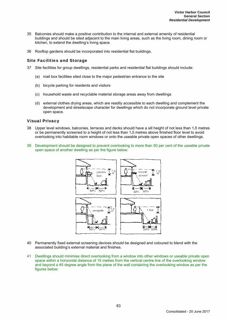
Victor Harbor Council General Section
Residential Development
83
35 Balconies should make a positive contribution to the internal and external amenity of residential buildings and should be sited adjacent to the main living areas, such as the living room, dining room or kitchen, to extend the dwelling’s living space.
36 Rooftop gardens should be incorporated into residential flat buildings.
Site Facilities and Storage 37 Site facilities for group dwellings, residential parks and residential flat buildings should include:
(a) mail box facilities sited close to the major pedestrian entrance to the site
(b) bicycle parking for residents and visitors
(c) household waste and recyclable material storage areas away from dwellings
(d) external clothes drying areas, which are readily accessible to each dwelling and complement the development and streetscape character for dwellings which do not incorporate ground level private open space.
Visual Privacy 38 Upper level windows, balconies, terraces and decks should have a sill height of not less than 1.5 metres
or be permanently screened to a height of not less than 1.5 metres above finished floor level to avoid overlooking into habitable room windows or onto the useable private open spaces of other dwellings.
39 Development should be designed to prevent overlooking to more than 50 per cent of the useable private open space of another dwelling as per the figure below:
40 Permanently fixed external screening devices should be designed and coloured to blend with the associated building’s external material and finishes.
41 Dwellings should minimise direct overlooking from a window into other windows or useable private open space within a horizontal distance of 15 metres from the vertical centre line of the overlooking window and beyond a 45 degree angle from the plane of the wall containing the overlooking window as per the figures below:
Consolidated - 20 June 2017
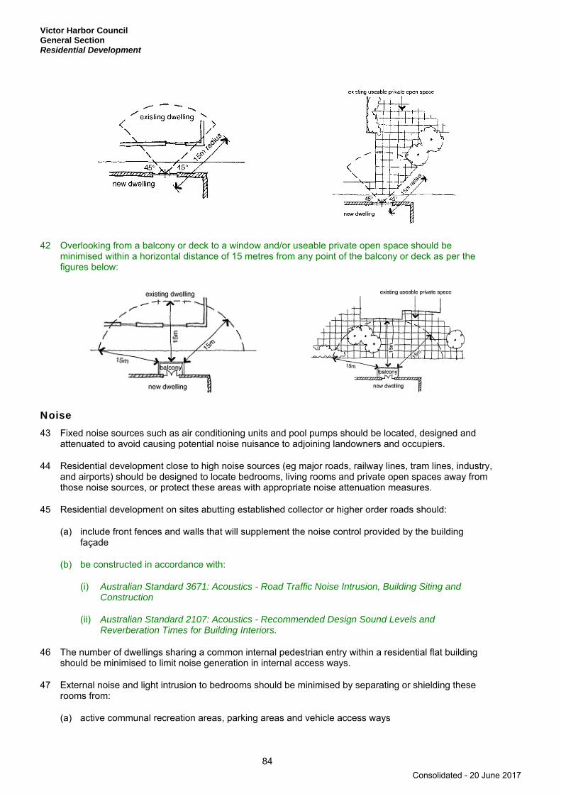
Victor Harbor Council General Section Residential Development
84
42 Overlooking from a balcony or deck to a window and/or useable private open space should be minimised within a horizontal distance of 15 metres from any point of the balcony or deck as per the figures below:
Noise 43 Fixed noise sources such as air conditioning units and pool pumps should be located, designed and
attenuated to avoid causing potential noise nuisance to adjoining landowners and occupiers.
44 Residential development close to high noise sources (eg major roads, railway lines, tram lines, industry, and airports) should be designed to locate bedrooms, living rooms and private open spaces away from those noise sources, or protect these areas with appropriate noise attenuation measures.
45 Residential development on sites abutting established collector or higher order roads should:
(a) include front fences and walls that will supplement the noise control provided by the building façade
(b) be constructed in accordance with:
(i) Australian Standard 3671: Acoustics - Road Traffic Noise Intrusion, Building Siting and Construction
(ii) Australian Standard 2107: Acoustics - Recommended Design Sound Levels and Reverberation Times for Building Interiors.
46 The number of dwellings sharing a common internal pedestrian entry within a residential flat building should be minimised to limit noise generation in internal access ways.
47 External noise and light intrusion to bedrooms should be minimised by separating or shielding these rooms from:
(a) active communal recreation areas, parking areas and vehicle access ways
Consolidated - 20 June 2017

Victor Harbor Council General Section
Residential Development
85
(b) service equipment areas and fixed noise sources on the same or adjacent sites
(c) living rooms with separate occupancy located adjacent, above or below.
Car Parking and Access 48 Driveway crossovers should be single width and appropriately separated, and the number should be
minimised to optimise the provision of on-street visitor parking.
49 On-site parking should be provided having regard to:
(a) the number, nature and size of proposed dwellings
(b) proximity to centre facilities, public and community transport within walking distance of the dwellings
(c) the anticipated mobility and transport requirements of the likely occupants, particularly groups such as aged persons
(d) availability of on-street car parking
(e) any loss of on-street parking arising from the development (eg an increase in number of driveway crossovers).
50 Parking areas servicing more than one dwelling should be of a size and location to:
(a) serve users, including pedestrians, cyclists and motorists, efficiently, conveniently and safely
(b) provide adequate space for vehicles to manoeuvre between the street and the parking area
(c) reinforce or contribute to attractive streetscapes.
51 On-site visitor parking spaces for group and multiple dwellings and residential flat buildings should be sited and designed to:
(a) serve users efficiently and safely
(b) not dominate internal site layout
(c) be clearly defined as visitor spaces not specifically associated with any particular dwelling
(d) ensure they are not sited behind locked garages and are accessible to visitors at all times.
52 Driveways on arterial roads that serve more than one dwelling should be designed to cater for the simultaneous two-way movements of the largest vehicles expected to enter and exit the site.
53 On-site parking and manoeuvring areas servicing development abutting arterial roads should be designed to enable all vehicles to enter and exit the site in a forward direction.
54 Internally driveways should provide safe and convenient access to and from the site, and be located so as to create a low impact on adjoining residential properties. In particular, driveway access to any building should have a maximum gradient of 1-in-5.
Undercroft Garaging of Vehicles 55 Undercroft garaging of vehicles should occur only where:
(a) the overall height and bulk of the development does not adversely impact on streetscape character or the amenity of adjacent properties
Consolidated - 20 June 2017

Victor Harbor Council General Section Residential Development
86
(b) vehicles can safely exit from the site without compromising pedestrian safety or causing conflict with other vehicles
(c) driveway gradients provide for safe and functional entry and exit
(d) driveways and adjacent walls, fencing and landscaping are designed to provide adequate sightlines from vehicles to pedestrians using the adjacent footpath
(e) openings into undercroft garage areas are designed to integrate with the main building so as to minimise visual impact
(f) landscaping, mounding and/or fencing is incorporated to improve its presentation to the street and to adjacent properties
(g) the overall streetscape character of the locality is not adversely impaired (eg visual impact, building bulk, front setbacks relative to adjacent development).
56 Buildings with four storeys or more above natural surface level should include provision for undercroft parking.
57 Semi-basement or undercroft car parking should be suitably integrated with building form.
58 In the case of semi-basement car parks where cars are visible, adequate screening and landscaping should be provided.
Dependent Accommodation 59 Dependent accommodation (ie accommodation where the living unit is connected to the same services
of the main dwelling) should be developed on the same allotment as the existing dwelling only where:
(a) the site is of adequate size and configuration and the minimum total site area is at least 600 square metres
(b) the accommodation has a small floor area relative to the associated main dwelling with a floor area not exceeding 60 square metres
(c) adequate outdoor space of a minimum of 100 square metres is provided for the use of all occupants
(d) adequate on-site car parking is provided by one additional car parking space being provided on the site
(e) the building is designed to, and comprises colours and materials that will, complement the original dwelling
(f) the building is ancillary to and dependant on the associated main dwelling.
Swimming Pools and Outdoor Spas 60 Swimming pools, outdoor spas and associated ancillary equipment and structures should be sited so as
to protect the privacy and amenity of adjoining residential land.
Consolidated - 20 June 2017

Victor Harbor Council General Section
Short-Term Workers Accommodation
87
Short-Term Workers Accommodation
OBJECTIVES
1 A range of appropriately located accommodation types supplied for seasonal and short-term workers.
PRINCIPLES OF DEVELOPMENT CONTROL
1 Accommodation intended to be occupied on a temporary basis by persons engaged in employment relating to the production or processing of primary produce including minerals should be located within existing townships or within primary production areas, where it directly supports and is ancillary to legitimate primary production activities or related industries.
2 Buildings used for short-term workers accommodation should:
(a) be designed and constructed to enhance their appearance
(b) provide for the addition of a carport, verandas or pergolas as an integral part of the building
(c) where located outside of townships, not jeopardise the continuation of primary production on adjoining land or elsewhere in the zone
(d) be supplied with service infrastructure such as power, water, and effluent disposal sufficient to satisfy the living requirements of workers.
3 Short-term workers accommodation should not be adapted or used for permanent occupancy.
4 A common amenities building should be provided for temporary forms of short-term accommodation such as caravan and camping sites.
Consolidated - 20 June 2017

Victor Harbor Council General Section Siting and Visibility
88
Siting and Visibility
OBJECTIVES
1 Protection of scenically attractive areas, particularly natural, rural and coastal landscapes.
PRINCIPLES OF DEVELOPMENT CONTROL
1 Development should be sited and designed to minimise its visual impact on:
(a) the natural, rural or heritage character of the area
(b) areas of high visual or scenic value, particularly rural and coastal areas
(c) views from the coast, near-shore waters, public reserves, tourist routes and walking trails
(d) the amenity of public beaches
(e) the skyline of the South Mount Lofty Ranges.
2 Buildings should be sited in unobtrusive locations and, in particular, should:
(a) be grouped together
(b) where possible be located in such a way as to be screened by existing vegetation when viewed from public roads.
3 Buildings outside of urban areas and in undulating landscapes should be sited in unobtrusive locations and in particular should be:
(a) sited below the ridgeline
(b) sited within valleys or behind spurs
(c) sited in such a way as to not be visible against the skyline when viewed from public roads
(d) set well back from public roads, particularly when the allotment is on the high side of the road.
4 Buildings and structures should be designed to minimise their visual impact in the landscape, in particular:
(a) the profile of buildings should be low and the rooflines should complement the natural form of the land
(b) the mass of buildings should be minimised by variations in wall and roof lines and by floor plans which complement the contours of the land
(c) large eaves, verandas and pergolas should be incorporated into designs so as to create shadowed areas that reduce the bulky appearance of buildings.
5 The nature of external surface materials of buildings should not detract from the visual character and amenity of the landscape.
6 The number of buildings and structures on land outside of urban areas should be limited to that necessary for the efficient management of the land.
Consolidated - 20 June 2017
Victor Harbor Council General Section
Siting and Visibility
89
7 Driveways and access tracks should be designed and surfaced to blend sympathetically with the landscape and to minimise interference with natural vegetation and landforms.
8 Development should be screened through the establishment of landscaping using locally indigenous plant species:
(a) around buildings and earthworks to provide a visual screen as well as shade in summer, and protection from prevailing winds
(b) along allotment boundaries to provide permanent screening of buildings and structures when viewed from adjoining properties and public roads
(c) along the verges of new roads and access tracks to provide screening and minimise erosion.
Consolidated - 20 June 2017
Victor Harbor Council General Section Sloping Land
90
Sloping Land
OBJECTIVES
1 Development on sloping land designed to minimise environmental and visual impacts and protect soil stability and water quality.
PRINCIPLES OF DEVELOPMENT CONTROL
1 Development and associated driveways and access tracks should be sited and designed to integrate with the natural topography of the land and minimise the need for earthworks.
2 Development and associated driveways and access tracks, including related earthworks, should be sited, designed and undertaken in a manner that:
(a) minimises their visual impact
(b) reduces the bulk of the buildings and structures
(c) minimises the extent of cut and/or fill
(d) minimises the need for, and the height of, retaining walls
(e) does not cause or contribute to instability of any embankment or cutting
(f) avoids the silting of watercourses
(g) protects development and its surrounds from erosion caused by water run-off.
3 Driveways and access tracks across sloping land should be accessible and have a safe, all-weather trafficable surface.
4 Development sites should not be at risk of landslip.
5 Development on steep land should include site drainage systems to minimise erosion and avoid adverse impacts on slope stability.
6 Steep sloping sites in unsewered areas should not be developed unless the physical characteristics of the allotments enable the proper siting and operation of an effluent drainage field suitable for the development intended.
7 The cutting and/or filling of land should:
(a) be kept to a minimum so as to preserve the natural form of the land and the native vegetation and should be constructed to allow landscaping to be installed above and over the wall if it is located closer to a road boundary than the dwelling
(b) only be undertaken in order to reduce the visual impact of buildings, including structures, or in order to construct water storage facilities for use on the allotment
(c) only be undertaken if the resultant slope can be stabilised to prevent erosion
(d) result in stable scree slopes which are covered with top soil and landscaped so as to preserve and enhance the natural character or assist in the re-establishment of the natural character of the area.
Consolidated - 20 June 2017

Victor Harbor Council General Section
Supported Accommodation, Housing for Aged Persons and People with Disabilities
91
Supported Accommodation, Housing for Aged Persons and People with Disabilities
OBJECTIVES
1 Provision of well designed supported accommodation for community groups with special needs in appropriate locations.
PRINCIPLES OF DEVELOPMENT CONTROL
1 Supported accommodation (including nursing homes, hostels, retirement homes, retirement villages, residential care facilities and special accommodation houses and housing for aged persons and people with disabilities) should be:
(a) located within walking distance of essential facilities such as convenience shops, health and community services and public and community transport as outlined in the following table:
Facility/Utility Desirable walking distance away (metres)
Public transport 200
Public road 100
Essential facilities (such as a shop selling food, chemist, bank, post office)
200
Desirable facilities (such as public park, hairdressing, library, health centre)
400
(b) located where on-site movement of residents is not unduly restricted by the slope of the land
(c) sited and designed to promote interaction with other sections of the community, without compromising privacy
(d) of a scale and appearance that reflects the residential style and character of the locality
(e) provided with public and private open space and landscaping.
2 Supported accommodation and housing for aged persons and people with disabilities should be designed to provide safe, secure, attractive, convenient and comfortable living conditions for residents that include:
(a) internal communal areas and private spaces
(b) useable recreation areas for residents and visitors, including visiting children
(c) spaces to accommodate social needs and activities, including social gatherings, internet use, gardening, keeping pets, preparing meals and doing personal laundry
(d) storage areas for items such as boats, trailers ,caravans and specialised equipment
(e) mail boxes and waste disposal areas within easy walking distance of all units
Consolidated - 20 June 2017

Victor Harbor Council General Section Supported Accommodation, Housing for Aged Persons and People with Disabilities
92
(f) ability to be accessed and visited by all members of the community including provision for a toilet and bathroom that can be easily modified to meet the needs of a person in a wheelchair
(g) step-less entries and edges to all porches
(h) level entry porches with gradient no steeper than 1-in-40, and of sufficient area to provide for wheelchair manoeuvrability
(i) minimum widths of entry doors to be 850 millimetres, internal doors 820 millimetres and internal corridors 1000 millimetres
(j) rooms of a size and proportion to provide adequate circulation spaces for wheelchairs
(k) no steps in showers and provide slip resistant floor surfaces
(l) designed to be easily modified to the changing needs and capacities of residents over time
(m) provide communal buildings that are easily accessible and centrally located for residents to access on foot or with the assistance of mobility aids, and are located to enable shared use with the surrounding community
(n) at least one bedroom capable of accommodating an area for a queen size bed and wardrobe together with adequate circulation space for a person in a wheelchair.
3 Access roads, ramps, pathways and driveways within supported accommodation and development incorporating housing for aged persons and people with disabilities should:
(a) not have gradients steeper than 1-in-20 with changes in gradient being clearly defined
(b) have flat areas on and adjacent to footpaths that allow for the passing of wheelchairs, resting places and areas for social interaction
(c) allow for interesting exercise routes and provide a variety of circulation options
(d) clearly separate pedestrian and vehicular traffic
(e) have walkway surfaces that are firm, even and slip resistant
(f) have footpaths that provide direct and easy access to public transport and other essential local services and facilities
(g) provide an even degree of lighting along all walking routes, entries and exits from residences
(h) directional signs to be provided which are clear and easy to read at day or night
(i) provide convenient access for emergency vehicles, visitors and residents
(j) provide space for manoeuvring cars and community buses
(k) include kerb ramps at pedestrian crossing points
(l) have level-surface passenger loading areas.
4 Car parking associated with supported accommodation and housing for aged persons and people with disabilities should:
(a) be conveniently located on site within easy walking distance (within 50 metres) of resident units
(b) be adequate for residents, staff, service providers and visitors
Consolidated - 20 June 2017
Victor Harbor Council General Section
Supported Accommodation, Housing for Aged Persons and People with Disabilities
93
(c) provide each residence with at least one private car parking space or garage area with minimum dimensions of 6 metres long by 3.8 metres wide
(d) include private parking spaces for independent living units
(e) include separate and appropriately marked places for people with disabilities and spaces for residents vehicles
(f) include covered and secure parking for residents’ vehicles
(g) have slip-resistant surfaces with gradients not steeper than 1-in-40
(h) allow ease of vehicle manoeuvrability
(i) be designed to allow the full opening of all vehicle doors
(j) minimise the impact of car parking on adjacent residences owing to visual intrusion and noise
(k) be appropriately lit to enable safe and easy movement to and from vehicles.
5 Supported accommodation should include:
(a) ground-level access or lifted access to all units
(b) an interesting and attractive outlook from units and communal areas for all residents including those in wheelchairs
(c) adequate living space allowing for the use of wheelchairs with an attendant
(d) storage for items such as small electric powered vehicles and other personal items, including facilities for recharging small electric powered vehicles
(e) a design and layout that provides a high level of internal accessibility and surveillance for safety and security.
6 Supported accommodation, housing for aged persons and people with disabilities may be developed at higher density than prescribed within the relevant zone or policy area, subject to compliance with other relevant provisions of the Development Plan.
Consolidated - 20 June 2017
Victor Harbor Council General Section Telecommunications Facilities
94
Telecommunications Facilities
OBJECTIVES
1 Telecommunications facilities provided to deliver communication services to the community.
2 Telecommunications facilities sited and designed to minimise visual impact on the amenity of the local environment.
PRINCIPLES OF DEVELOPMENT CONTROL
1 Telecommunications facilities should:
(a) be located in a coordinated manner to deliver communication services efficiently
(b) use materials and finishes that minimise visual impact
(c) have antennae located as close as practical to the support structure
(d) be located primarily in industrial, commercial, business, office, centre and rural zones
(e) where technically feasible, be co-located with other telecommunications facilities
(f) incorporate landscaping to screen the development, particularly equipment shelters and huts
(g) be designed and sited to minimise the visual impact on the character and amenity of the local environment, in particular visually prominent areas, main focal points and significant vistas.
2 Telecommunications facilities in areas of high visitation and community use should use innovative design techniques (eg sculpture and other artworks) where possible and where the resulting design would positively contribute to the character of the area.
3 Telecommunications facilities should be located in residential zones only if sited and designed to minimise visual impact by:
(a) using existing buildings and vegetation for screening
(b) incorporating the facility within an existing structure that may serve another purpose
(c) taking into account the size, scale, context and characteristics of existing structures, landforms and vegetation so as to complement the local environment.
4 Telecommunications facilities should not have a direct or significant effect on the amenity, character and settings of Historic Conservation Areas, local heritage places, State heritage places or State Heritage Areas.
Consolidated - 20 June 2017

Victor Harbor Council General Section
Tourism Development
95
Tourism Development
OBJECTIVES
1 Environmentally sustainable and innovative tourism development.
2 Tourism development that assists in the conservation, interpretation and public appreciation of significant natural and cultural features including State or local heritage places.
3 Tourism development that sustains or enhances the local character, visual amenity and appeal of the area.
4 Tourism development that protects areas of exceptional natural value, allows for appropriate levels of visitation, and demonstrates an environmental analysis and design response which enhances environmental values.
5 Tourism development in rural areas that does not adversely affect the use of agricultural land for primary production.
6 Tourism development that contributes to local communities by adding vitality to neighbouring townships, regions and settlements.
7 Increased opportunities for visitors to stay overnight.
8 Ensure new development, together with associated bushfire management minimise the threat and impact of bushfires on life and property while protecting the environment.
PRINCIPLES OF DEVELOPMENT CONTROL
1 Tourism development should have a functional or locational link with its natural, cultural or historical setting.
2 Tourism development and any associated activities should not damage or degrade any significant natural and cultural features.
3 Tourism development should ensure that its scale, form and location will not overwhelm, over commercialise or detract from the intrinsic natural values of the land on which it is sited or the character of its locality.
4 Tourism development should, where appropriate, add to the range of services and accommodation types available in an area.
5 Any upgrading of infrastructure to serve tourism development should be consistent with the landscape and the intrinsic natural values of the land and the basis of its appeal.
6 Major tourism developments should generally be located within designated areas and existing townships, towns or cities.
Tourism Development in Association with Dwelling(s) 7 Tourist facilities developed on the site of a dwelling should not detrimentally affect residential amenity.
8 Car parking for tourist accommodation associated with a dwelling should be provided at the rate of one space for each guest room or suite of rooms, and ensure that:
Consolidated - 20 June 2017

Victor Harbor Council General Section Tourism Development
96
(a) parking areas are attractively developed and landscaped, or screen fenced, and do not dominate the street frontage
(b) the bedrooms of residential neighbours are suitably shielded from noise and headlight glare associated with guest vehicle movements
(c) a domestic character is retained through the scale and appearance of landscaping and paving materials that provide a suitable all-weather surface.
Tourism Development Outside Townships 9 Tourist developments should demonstrate excellence in design to minimise potential impacts or
intrusion on primary production activities and on areas of high conservation, landscape and cultural value.
10 Tourism developments in rural areas should be sited and designed to minimise impacts and have a functional or locational link with either of the following:
(a) the surrounding agricultural production or processing
(b) the natural, cultural or historical setting of the area.
11 Tourism developments in rural areas should primarily be developed in association with one or more of the following:
(a) agricultural, horticultural, viticultural or winery development
(b) heritage places and areas
(c) public open space and reserves
(d) walking and cycling trails
(e) interpretive infrastructure and signs.
12 Where appropriate, tourism developments in areas outside townships should:
(a) adapt and upgrade existing buildings of heritage value
(b) seek to improve conditions in disturbed or degraded areas on the site.
13 Advertisements associated with tourism developments should:
(a) not exceed 0.5 square metres in area for each display
(b) be limited to no more than two per site
(c) be located on the same site as the tourist development
(d) not be internally illuminated.
14 Tourism development in rural areas should occur only where it:
(a) incorporates a separation distance or buffers to avoid conflict with existing rural industries or agriculture or otherwise is designed to overcome the potential impacts associated with the adjoining land use (such as noise, dust, spray drift, odour and traffic)
(b) will not give rise to demands for infrastructure and services, especially on public lands, that are inappropriate to the primary purpose of the zone and/or policy area.
Consolidated - 20 June 2017

Victor Harbor Council General Section
Tourism Development
97
15 Tourism development, particularly in remote areas should be designed to minimise energy and water demands and incorporate alternative, sustainable technologies that use renewable energy sources and/or treat and reuse stormwater and wastewater to minimise reliance on mains services.
16 Natural features, signs and walkways should be used to manage and minimise potential risks of visitors damaging areas of cultural or natural significance, fragile areas, and areas of highest environmental value.
17 The visual and ambient impact of vehicles should be minimised by placing roadways and parking areas in unobtrusive locations.
Residential Parks and Caravan and Tourist Parks 18 Residential parks which are principally designed for residents should be located in areas with access to
employment, shops, schools, public transport and community and recreation facilities.
19 Residential parks and Caravan and Tourist parks should be designed to:
(a) minimise potential conflicts between long-term residents and short-term tourists
(b) protect the privacy and amenity of occupants through landscaping and fencing
(c) minimise traffic speeds and provide a safe environment for pedestrians
(d) include centrally located recreation areas
(e) include extensive landscaping that enhances the appearance of the locality, with a landscape buffer around the perimeter of the site
(f) ensure that adequate amenity blocks (showers, toilets, laundry and kitchen facilities) and service facilities (eg public telephones, kiosks and restaurants) are provided to serve the population to be accommodated by the facility.
20 Visitor car parking should be provided at the rate of:
(a) one space per 10 sites to be used for accommodation for parks with less than 100 sites
(b) one space per 15 sites to be used for accommodation for parks with greater than 100 sites.
21 On-site visitor parking in Caravan and Tourist parks should:
(a) be designed and located to be accessible to visitors at all times
(b) not dominate the internal site layout
(c) be clearly defined as visitor spaces and not specifically associated with any particular accommodation site.
22 Long-term occupation of Caravan and Tourist parks should not lead to the displacement of existing tourist accommodation, particularly in important tourist destinations, such as in coastal or riverside locations.
23 A minimum of 12.5 per cent of a park should comprise communal open space, landscaped areas and recreation areas.
24 Landscaping should comprise locally indigenous species that are appropriate to the development and the subject land, and facilitate amenity and environmental sustainability.
Consolidated - 20 June 2017

Victor Harbor Council General Section Transportation and Access
98
Transportation and Access
OBJECTIVES
1 A comprehensive, integrated, affordable and efficient air, rail, sea, road, cycle and pedestrian transport system that will:
(a) provide equitable access to a range of public, community and private transport services for all people
(b) ensure a high level of safety
(c) effectively support the economic development of the State
(d) have minimal negative environmental and social impacts
(e) maintain options for the introduction of suitable new transport technologies.
2 Development that:
(a) provides safe and efficient movement for all motorised and non-motorised transport modes
(b) ensures access for vehicles including emergency services, public infrastructure maintenance and commercial vehicles
(c) provides off street parking
(d) is appropriately located so that it supports and makes best use of existing transport facilities and networks.
3 A road hierarchy that promotes safe and efficient transportation in an integrated manner throughout the State.
4 Provision of safe, pleasant, accessible, integrated and permeable pedestrian and cycling networks.
5 Safe and convenient freight movement throughout the State.
PRINCIPLES OF DEVELOPMENT CONTROL
Land Use 1 Land uses arranged to support the efficient provision of sustainable transport networks and encourage
their use.
Movement Systems 2 Development should be integrated with existing transport networks, particularly major rail and road
corridors as shown on Location Maps and Overlay Maps - Transport, and designed to minimise its potential impact on the functional performance of the transport networks.
3 Transport corridors should be sited and designed so as to not unreasonably interfere with the health and amenity of adjacent sensitive land uses.
4 Roads should be sited and designed to blend with the landscape and be in sympathy with the terrain.
Consolidated - 20 June 2017
Victor Harbor Council General Section
Transportation and Access
99
5 Land uses that generate large numbers of visitors such as shopping centres and areas, places of employment, schools, hospitals and medium to high density residential uses should be located so that they can be serviced by existing transport networks and encourage walking and cycling.
6 Development generating high levels of traffic, such as schools, shopping centres and other retail areas, entertainment and sporting facilities, should incorporate passenger pick-up and set down areas. The design of such areas should ensure interference to existing traffic is minimised and give priority to pedestrians, cyclists and public and community transport users.
7 The location and design of public and community transport set-down and pick-up points should maximise safety and minimise the isolation and vulnerability of users.
8 Development should provide safe and convenient access for all anticipated modes of transport including cycling, walking, public and community transport, and motor vehicles.
9 Development at intersections, pedestrian and cycle crossings, and crossovers to allotments should maintain or enhance sightlines for motorists, cyclists and pedestrians to ensure safety for all road users and pedestrians.
10 Driveway cross-overs affecting pedestrian footpaths should maintain the level of the footpath.
11 Development should discourage commercial and industrial vehicle movements through residential streets and adjacent other sensitive land uses such as schools.
12 Industrial/commercial vehicle movements should be separated from passenger vehicle car-parking areas.
13 Development should make sufficient provision on site for the loading, unloading and turning of all traffic likely to be generated.
Cycling and Walking 14 Development should ensure that a permeable street and path network is established that encourages
walking and cycling through the provision of safe, convenient and attractive routes with connections to adjoining streets, paths, open spaces, schools, public and community transport stops and activity centres.
15 Development should provide access, and accommodate multiple route options, for cyclists by enhancing and integrating with open space networks, recreational trails, parks, reserves and recreation areas.
16 Cycling and pedestrian networks should be designed to be permeable and facilitate direct and efficient passage to neighbouring networks and facilities.
17 New developments should give priority to and not compromise existing designated bicycle routes.
18 Where development coincides with, intersects or divides a proposed bicycle route or corridor, development should incorporate through-access for cyclists.
19 Developments should encourage and facilitate cycling as a mode of transport by incorporating end-of-journey facilities including:
(a) showers, changing facilities, and secure lockers
(b) signage indicating the location of bicycle facilities
(c) secure bicycle parking facilities.
20 Pedestrian facilities and networks should be designed and provided in accordance with relevant provisions of the Australian Standards and Austroads Guide to Traffic Engineering Practice Part 13.
Consolidated - 20 June 2017
Victor Harbor Council General Section Transportation and Access
100
21 Cycling facilities and networks should be designed and provided in accordance with the relevant provisions of the Australian Standards and Austroads Guide to Traffic Engineering Practice Part 14.
Access 22 Development should have direct access from an all weather public road.
23 Development should be provided with safe and convenient access which:
(a) avoids unreasonable interference with the flow of traffic on adjoining roads
(b) provides appropriate separation distances from existing roads or level crossings
(c) accommodates the type and volume of traffic likely to be generated by the development or land use and minimises induced traffic through over-provision
(d) is sited and designed to minimise any adverse impacts on the occupants of and visitors to neighbouring properties.
24 Development should not restrict access to publicly owned land such as recreation areas.
25 The number of vehicle access points onto arterial roads shown on Overlay Maps - Transport should be minimised, and where possible access points should be:
(a) limited to local roads
(b) shared between developments.
26 The number of access points for cyclists and pedestrians onto all adjoining roads should be maximised.
27 Development with access from roads with existing or projected traffic volumes exceeding 6000 vehicles per day should be sited to avoid the need for vehicles to reverse on to or from the road.
28 Development with access from arterial roads or roads as shown on Overlay Maps - Transport should be sited to avoid the need for vehicles to reverse on to or from the road.
29 Driveways, access tracks and parking areas should be designed and constructed to:
(a) follow the natural contours of the land
(b) minimise excavation and/or fill
(c) minimise the potential for erosion from run-off
(d) avoid the removal of existing vegetation
(e) be consistent with Australian Standard AS 2890 Parking facilities.
Access for People with Disabilities 30 Development should be sited and designed to provide convenient access for people with a disability.
31 Where appropriate and practical, development should provide for safe and convenient access to the coast and beaches for disabled persons.
Vehicle Parking 32 Development should provide off-street vehicle parking and specifically marked disabled car parking
places to meet anticipated demand in accordance with Table ViH/2 - Off Street Vehicle Parking Requirements unless one or more of the following conditions are met:
Consolidated - 20 June 2017
Victor Harbor Council General Section
Transportation and Access
101
(a) an agreement is reached between the Council and the applicant for a reduced number of parking spaces
(b) it is located within the Regional Centre Zone, Neighbourhood Centre Zone or Local Centre Zone and the car parking shortfall is provided on an alternative site which achieves all of the following:
(i) the alternative site is located on land adjacent to the primary site
(ii) the alternative site is easily accessible and available for vehicle parking when required
(iii) a shared or reciprocal parking agreement that is secured with a registered and binding agreement by way of rights of way and/or easements that are registered on the respective certificates of title for all of the associated land parcels
(c) an agreement has been reached with Council that a financial contribution, at the specified rate per car park, will be paid to the Council Car Park Fund for any under-provision of on-site car parking, measured against the rate of parking stipulated in Table ViH/2 - Off Street Vehicle Parking Requirements, and the development is located in one of the following locations:
(i) Local Centre Zone
(ii) Neighbourhood Centre Zone
(iii) Regional Centre Zone within the designated ‘Car Parking Fund Areas 1, 2 or 3’ shown on Concept Plan Map ViH/2 - Car Parking Fund Areas (Regional Centre)
(d) The development involves the adaptive use of a heritage place identified in Table ViH/5 - State Heritage Places or in Table ViH/4 - Local Heritage Places.
33 Development should be consistent with Australian Standard AS 2890 Parking facilities.
34 Vehicle parking areas should be sited and designed in a manner that will:
(a) facilitate safe and convenient pedestrian linkages to the development and areas of significant activity or interest in the vicinity of the development
(b) include safe pedestrian and bicycle linkages that complement the overall pedestrian and cycling network
(c) not inhibit safe and convenient traffic circulation
(d) result in minimal conflict between customer and service vehicles
(e) avoid the necessity to use public roads when moving from one part of a parking area to another
(f) minimise the number of vehicle access points to public roads
(g) avoid the necessity for backing onto public roads
(h) where reasonably possible, provide the opportunity for shared use of car parking and integration of car parking areas with adjoining development to reduce the total extent of vehicle parking areas and the requirement for access points
(i) not dominate the character and appearance of a site when viewed from public roads and spaces
(j) provide landscaping that will shade and enhance the appearance of the vehicle parking areas.
Consolidated - 20 June 2017
Victor Harbor Council General Section Transportation and Access
102
35 Vehicle parking areas should be designed to reduce opportunities for crime by:
(a) maximising the potential for passive surveillance by ensuring they can be overlooked from nearby buildings and roads
(b) incorporating walls and landscaping that do not obscure vehicles or provide potential hiding places
(c) being appropriately lit
(d) having clearly visible walkways.
36 Where parking areas are not obviously visible or navigated, signs indicating the location and availability of vehicle parking spaces associated with businesses should be displayed at locations readily visible to customers.
37 Parking areas that are likely to be used during non daylight hours should provide floodlit entrance and exit points and site lighting directed and shaded in a manner that will not cause nuisance to adjacent properties or users of the car park.
38 Parking areas should be sealed or paved in order to minimise dust and mud nuisance.
39 To assist with stormwater detention and reduce heat loads in summer, vehicle parking areas should include soft (living) landscaping.
40 Parking areas should be line-marked to indicate parking bays, movement aisles and direction of traffic flow.
Consolidated - 20 June 2017

Victor Harbor Council General Section
Waste
103
Waste
OBJECTIVES
1 Development that, in order of priority, avoids the production of waste, minimises the production of waste, reuses waste, recycles waste for reuse, treats waste and disposes of waste in an environmentally sound manner.
2 Development that includes the treatment and management of solid and liquid waste to prevent undesired impacts on the environment including, soil, plant and animal biodiversity, human health and the amenity of the locality.
PRINCIPLES OF DEVELOPMENT CONTROL
1 Development should be sited and designed to prevent or minimise the generation of waste (including wastewater) by applying the following waste management hierarchy in the order of priority as shown below:
(a) avoiding the production of waste
(b) minimising waste production
(c) reusing waste
(d) recycling waste
(e) recovering part of the waste for re-use
(f) treating waste to reduce the potentially degrading impacts
(g) disposing of waste in an environmentally sound manner.
2 The storage, treatment and disposal of waste materials from any development should be achieved without risk to health or impairment of the environment.
3 Development should avoid as far as practical, the discharge or deposit of waste (including wastewater) onto land or into any waters (including processes such as seepage, infiltration or carriage by wind, rain, sea spray, stormwater or by the rising of the water table).
4 Untreated waste should not be discharged to the environment, and in particular to any water body.
5 Development should include appropriately sized area to facilitate the storage of receptacles that will enable the efficient recycling of waste.
6 Development that involves the production and/or collection of waste and/or recyclable material should include designated collection and storage area(s) that are:
(a) screened and separated from adjoining areas
(b) located to avoid impacting on adjoining sensitive environments or land uses
(c) designed to ensure that wastes do not contaminate stormwater or enter the stormwater collection system
(d) located on an impervious sealed area graded to a collection point in order to minimise the movement of any solids or contamination of water
Consolidated - 20 June 2017
Victor Harbor Council General Section Waste
104
(e) protected from wind and stormwater and sealed to prevent leakage and minimise the emission of odours
(f) stored in such a manner that ensures that all waste is contained within the boundaries of the site until disposed of in an appropriate manner.
Wastewater 7 The disposal of wastewater to land should only occur where methods of wastewater reduction and
reuse are unable to remove the need for its disposal, and where its application to the land is environmentally sustainable.
8 Wastewater lagoons should not be sited in any of the following areas:
(a) within land subject to a 1-in-100 year average return interval flood event
(b) within 50 metres of the top of the bank of a watercourse
(c) within 500 metres of the coastal high water mark
(d) where the base of the lagoon would be below any seasonal water table.
9 Artificial wetland systems for the storage of treated wastewater, such as wastewater lagoons, should be:
(a) sufficiently separated from adjoining sensitive uses to minimise potential adverse odour impacts
(b) sited and designed to minimise potential public health risks arising from the breeding of mosquitoes.
Waste Treatment Systems 10 Development that produces any sewage or effluent should be connected to a waste treatment system
that complies with (or can comply with) the relevant public and environmental health legislation applying to that type of system.
11 The methods for, and siting of, effluent and waste storage, treatment and disposal systems should minimise the potential for environmental harm and adverse impacts on:
(a) the quality of surface and groundwater resources
(b) public health
(c) the amenity of a locality
(d) sensitive land uses.
12 Waste treatment should only occur where the capacity of the treatment facility is sufficient to accommodate likely maximum daily demands including a contingency for unexpected high flows and breakdowns.
13 Any on-site wastewater treatment system/ re-use system or effluent drainage field should be located within the allotment of the development that it will service.
14 A dedicated on-site effluent disposal area should not include any areas to be used for, or could be reasonably foreseen to be used for, private outdoor open space, driveways, car parking or outbuildings.
15 The spreading or discharging of treated liquid or solid waste onto the ground should only occur where the disposal area consists of soil and vegetation that has the capacity to store and use the waste without contaminating soil or surface or ground water resources or damaging crops.
Consolidated - 20 June 2017

Victor Harbor Council General Section
Waste
105
16 Stock slaughter works, poultry processors, saleyards, piggeries, cattle feedlots, milking sheds, milk processing works, fish processing works, wineries, distilleries, tanneries and fellmongeries, composting works, waste or recycling depots and concrete batching works should have a wastewater management system that is designed so as not to discharge wastes generated by the premises:
(a) into any waters
(b) onto land in a place where it is reasonably likely to enter any waters by processes such as:
(i) seepage
(ii) infiltration
(iii) carriage by wind, rain, sea spray, or stormwater
(iv) the rising of the watertable.
17 Winery waste management systems should be designed to ensure:
(a) surface runoff does not occur from the wastewater irrigation area at any time
(b) wastewater is not irrigated onto waterlogged areas, land within 50 metres of a creek, or swamp or domestic or stock water bore, or land subject to flooding, steeply sloping land, or rocky or highly permeable soil overlaying an unconfined aquifer
(c) wastewater is not irrigated over an area which is within 50 metres of any residence on neighbouring land or 10 metres of any type of publicly owned land
(d) wastewater is released using low trajectory low pressure sprinklers, drip irrigators or agricultural pipe, and is not sprayed more than 1.5 metres into the air or in fine droplets if there is a potential for the spread of diseases from the wastewater
(e) stormwater run-off from areas which are contaminated with grape or grape products is drained to winery waste management systems during vintage periods
(f) stormwater from roofs and clean hard paved surfaces is diverted away from winery waste management systems and disposed of in an environmentally sound manner or used for productive purposes.
Consolidated - 20 June 2017

Victor Harbor Council General Section Waste Management Facilities
106
Waste Management Facilities
OBJECTIVES
1 The orderly and economic development of waste management facilities in appropriate locations.
2 Minimisation of human and environmental health impacts from the location and operation of waste management facilities.
3 Protection of waste management facilities from incompatible development.
PRINCIPLES OF DEVELOPMENT CONTROL
1 Waste management facilities should be located and designed to minimise adverse impacts on both the site and surrounding areas from the generation of surface water and groundwater pollution, traffic, noise, odours, dust, vermin, weeds, litter, gas and visual impact.
2 Waste management facilities in the form of land fill and organic processing facilities should not be located in existing or future township, living, residential, centre, office, business, institutional or environmental protection, conservation, landscape, water protection and open space areas.
3 Waste management facilities should not be located where access to the facility requires, or is likely to involve, the use of non-arterial roads in adjacent residential areas.
4 Waste management facilities should:
(a) be appropriately separated from sensitive land uses and environmentally-sensitive areas
(b) incorporate the separation distance between the waste operations area (including all closed, operating and future cells) and sensitive uses within the development site as illustrated in the figure below:
(c) not incorporate other land uses and activities within the separation distance unless they are compatible with both a waste management facility and any adjacent land uses.
5 Separation and/or noise attenuation should be used to ensure noise generation associated with the waste management operation does not unreasonably interfere with the amenity of sensitive land uses.
Consolidated - 20 June 2017

Victor Harbor Council General Section
Waste Management Facilities
107
6 Sufficient area should be provided within the waste operations area for the:
(a) maximum expected volume of material on the site at any one time
(b) containment of potential groundwater and surface water contaminants
(c) diversion of clean stormwater away from the waste and potentially-contaminated areas.
7 Processing facilities and operational areas should be screened from public view.
8 Waste management sites should be accessed by appropriately constructed and maintained roads.
9 Traffic circulation movements within any waste management site should:
(a) be of a dimension and constructed to support all vehicles transporting waste
(b) enable all vehicles to enter and exit the site in a forward direction.
10 Suitable access for emergency vehicles should be provided to and within waste management sites.
11 Chain wire mesh or pre-coated painted metal fencing to a minimum height of 2 metres should be erected on the perimeter of a waste management facility site to prevent access other than at entry points.
12 Plant, equipment or activities that could cause a potential hazard to the public should be enclosed by a security fence.
13 Litter control measures that minimise the incidence of wind blown litter should be provided.
14 The waste operations area of a landfill or organic waste processing facility should be sited at least:
(a) 3 kilometres from an airfield used by commercial aircraft to minimise the risk of bird strikes to aircraft
(b) 500 metres from:
(i) the boundaries of the allotment
(ii) the nearest dwelling, shop, office, public institution or other building designed primarily for human occupation in the case of an organic waste processing facility for the composting of waste
(c) 250 metres from a public open space reserve, forest reserve, national park, conservation zone or policy area
(d) 100 metres from:
(i) the nearest surface water (whether permanent or intermittent)
(ii) a 1-in-100 year average return interval flood event area.
15 The waste operations area of a landfill should not be located on land:
(a) that is subject to land slipping
(b) with ground slopes greater than 10 per cent, except where the site incorporates a disused quarry.
16 The waste operations area of an organic waste processing facility should not be located on land:
(a) that is subject to land slipping
Consolidated - 20 June 2017

Victor Harbor Council General Section Waste Management Facilities
108
(b) with ground slopes greater than 6 per cent
(c) where the interface of the engineered landfill liner and natural soils would be within any of the following:
(i) 15 metres of unconfined aquifers bearing groundwater with less than 3000 milligrams per litre total dissolved salts
(ii) 5 metres of groundwater with a water quality of 3000 to 12 000 milligrams per litre total dissolved salts
(iii) 2 metres of groundwater with a water quality of greater than 12 000 milligrams per litre total dissolved salts.
17 Where required, a leachate barrier should be provided between the operational areas and underlying soil and groundwater.
18 Landfill activities that have a total storage capacity exceeding 230 000 cubic metres should make sustainable use of landfill gas emissions. For smaller landfill activities, if the sustainable use of the landfill gas emissions is not practical or feasible, flaring should be used to avoid gases being vented directly to the air.
Consolidated - 20 June 2017

Victor Harbor Council Zone Section
109
Zone Section
Consolidated - 20 June 2017

Consolidated - 20 June 2017
Victor Harbor Council Zone Section
Caravan and Tourist Park Zone
111
Caravan and Tourist Park Zone
Refer to the Map Reference Tables for a list of the maps that relate to this zone.
OBJECTIVES
1 A zone primarily for short-term tourist accommodation and associated facilities.
2 A zone accommodating a range of short-term tourist accommodation predominantly in the form of caravan and camping sites, cabins, serviced apartments and transportable dwellings surrounded by open landscaped areas.
3 Development that is designed to enhance the natural features of the local environment, including visual amenity, landforms, fauna and flora.
4 Development that contributes to the desired character of the zone.
DESIRED CHARACTER
This zone primarily accommodates a range of tourist accommodation uses, including camping sites, caravans and cabins.
Dwellings and long-term accommodation will not lead to the displacement of existing tourist accommodation in high demand locations.
Buildings will be a maximum height of two storeys and blend in with the rural and natural background. The visual impact of the park will be minimal from scenic vantage points, public lookouts and tourist routes.
Vegetation buffers and landscaping will be important in integrating the park into the landscape and providing screening from surrounding land uses, as well as reducing visual and noise impacts and providing privacy for park users.
Circulation and movement within the park will be pedestrian friendly and promote low speed vehicle movement.
PRINCIPLES OF DEVELOPMENT CONTROL
Land Use 1 The following forms of development are envisaged in the zone:
▪ amenity block, including shower, toilet, laundry and kitchen facilities ▪ cabin ▪ caravan park ▪ caravan permanently fixed to land ▪ camping ground ▪ recreation area including tennis court, basketball court, playground ▪ swimming pool/spa ▪ tourist park and other forms of tourist accommodation.
2 Development listed as non-complying is generally inappropriate.
Consolidated - 20 June 2017

Victor Harbor Council Zone Section Caravan and Tourist Park Zone
112
Form and Character 3 Development should not be undertaken unless it is consistent with the desired character for the zone.
4 Permanent buildings should be limited to a dwelling (manager’s house), shop (in association with and ancillary to a caravan and tourist park), community or recreational facility and toilets/amenities.
5 Recreation facilities should be provided of a scale that is suitable to maintain the open natural character of the area and ancillary to the primary role and function of the park.
6 The total number of tourist accommodation sites in the park should be at least 60 per cent of the total number of sites available.
7 Every caravan, cabin and dwelling site should be greater than 81 square metres in area.
8 Landscaping should form an integral part of the design and be used to define spaces, reinforce internal networks, screen utility areas and enhance the visual amenity of the area.
Car Parking and Access 9 Every caravan, cabin or dwelling site should have parking for at least one vehicle, either located on the
site or grouped within the park.
10 Internal road surfaces should be surfaced to prevent dust becoming a nuisance.
Street and Boundary Setbacks 11 Every dwelling, annex, caravan fixed to land, recreational facility or amenities building should be set
back a minimum of:
(a) 1 metre from an internal road
(b) 6 metres from a public road
(c) 2 metres from the boundary of the caravan park or camping ground.
Natural Hazards 12 In areas prone to flooding, bushfire or other natural hazards, buildings and structures (including
annexes attached to caravans or caravans fixed to land) should be designed and constructed so that they can be removed in the event of a hazard.
Land Division 13 No additional allotment(s) should be created wholly or partly within the zone except where a lease or
license agreement is made, granted or accepted under the Residential Parks Act 2007.
PROCEDURAL MATTERS
Complying Development Complying developments are prescribed in Schedule 4 of the Development Regulations 2008.
Consolidated - 20 June 2017
Victor Harbor Council Zone Section
Caravan and Tourist Park Zone
113
Non-complying Development Development (including building work, a change in the use of land, or division of an allotment) for the following is non-complying:
Form of Development Exceptions
Amusement machine centre
Bus depot
Cemetery
Commercial forestry
Community centre Except where in association with and ancillary to tourist accommodation.
Consulting room
Crematorium
Dairy
Dam
Dwelling Except for a manager’s residence in association with and ancillary to tourist accommodation.
Educational establishment
Farming
Fuel depot
Horse keeping
Horticulture
Hospital
Hotel
Indoor recreation centre Except where in association with and ancillary to tourist accommodation.
Industry
Intensive animal keeping
Land division which results in the creation of additional allotment(s) either wholly or partly within the zone.
Except where a lease or licence agreement is made, granted or accepted under the Residential Parks Act 2007.
Marina
Motor repair station
Nursing home
Office Except where in association with and ancillary to tourist accommodation.
Petrol filling station
Consolidated - 20 June 2017
Victor Harbor Council Zone Section Caravan and Tourist Park Zone
114
Form of Development Exceptions
Place of worship
Pre-school
Prescribed mining operations
Public service depot
Residential flat building
Restaurant Except where it is both: (a) less than 150 square metres in gross floor area (b) in association with and ancillary to tourist accommodation.
Road transport terminal
Service trade premises
Shop or group of shops Except where it is both: (a) less than 150 square metres in gross floor area (b) in association with and ancillary to tourist accommodation.
Stadium
Stock sales yard
Stock slaughter works
Store
Warehouse
Waste reception, storage, treatment or disposal
Wrecking yard
Public Notification Categories of public notification are prescribed in Schedule 9 of the Development Regulations 2008.
Further, the following forms of development (except where the development is non-complying) are designated:
Category 1 Category 2
Amenity block, including shower, toilet, laundry and kitchen facilities
Cabin
Camping ground
Caravan park
Caravan permanently fixed to land
Recreation area
Swimming pool
Tourist park
Consolidated - 20 June 2017

Victor Harbor Council Zone Section
Coastal Conservation Zone
115
Coastal Conservation Zone
Refer to the Map Reference Tables for a list of the maps that relate to this zone.
OBJECTIVES
1 To enhance and conserve the natural features of the coast including visual amenity, landforms, fauna and flora.
2 Low-intensity recreational and tourist uses located where environmental impacts on the coast will be minimal.
3 Development that contributes to the desired character of the zone.
DESIRED CHARACTER
The southern part (majority) of Granite Island is for the purpose of conservation and represents an important penguin habitat and supports coastal native vegetation with plants of conservational significance. Development is to be minimal and compatible with conservation, natural landscapes and passive recreational activities and is to include small scale structures such as public shelters and interpretive signage.
The northern part of Granite Island is a privately leased area and consists of tourist development with associated educational facilities, horse tram route, vehicle access road, jetty fishing (adjacent), bistro and gardens. Tourist development and associated educational, recreational and service facilities are envisaged within this precinct to support ecologically based tourism. Development is envisaged to be confined to the precinct and designed and sited in context with the natural surrounds, maritime heritage and maintenance of views from Victor Harbor.
Conservation and protection will be afforded to the Granite Island Causeway, Screw-pile jetty, Breakwater and Cutting as State Heritage Places.
PRINCIPLES OF DEVELOPMENT CONTROL
Land Use 1 The following forms of development are envisaged in the zone:
▪ conservation work ▪ educational facility where it is located within Precinct 1 Granite Island Tourist Facilities ▪ interpretive signage and facilities ▪ recreational facility where it is located within Precinct 1 Granite Island Tourist Facilities ▪ tourist facility where it is located within Precinct 1 Granite Island Tourist Facilities.
2 Development listed as non-complying is generally inappropriate.
3 Buildings and structures should mainly be for essential purposes, such as shelters and toilet facilities associated with public recreation, navigation purposes or necessary minor public works.
4 Development involving the removal of shell grit or sand, other than for coastal protection works purposes, or the disposal of domestic and industrial waste should not be undertaken.
5 Aquaculture inlet and outlet pipes should not be developed unless one or more of the following applies:
Consolidated - 20 June 2017
Victor Harbor Council Zone Section Coastal Conservation Zone
116
(a) the adjoining land is located in an aquaculture zone
(b) the environmental impacts will be minimal.
Form and Character 6 Development should not be undertaken unless it is consistent with the desired character for the zone.
7 Development should be designed and sited to be compatible with conservation and enhancement of the coastal environment and scenic beauty of the zone.
8 Development should:
(a) not adversely impact on the ability to maintain the coastal frontage in a stable and natural condition
(b) minimise vehicle access points to the area that is the subject of the development
(c) be landscaped with locally indigenous plant species to enhance the amenity of the area and to screen buildings from public view
(d) utilise external low reflective materials and finishes that will minimise glare and blend in with its surroundings.
9 Where public access is necessary in sensitive locations, walkways and fencing should be provided to effectively control access.
10 Tourist, recreational and educational facilities should be compatible with the conservation significance of features or sites, and the protection of fauna, flora and marine life in the locality.
11 Development should complement the existing design and contextual qualities of the causeway and not restrict the primary function of the causeway as the major tourist path to and from Granite Island.
12 Pedestrian shelters should be of low-profile, rustic in character and built of local materials (such as granite and timber).
13 Significant stands of existing natural vegetation should be protected and conserved.
14 Signs should be for direction, identification and interpretation only and be discrete in size, design and colours.
Land Division 15 Land division should only occur where:
(a) no additional allotments are created wholly or partly within the zone
(b) there is no increase in the number of allotments with direct access to the coast or a reserve including by creation of land under rights of way or community titles.
PRECINCT SPECIFIC PROVISIONS
Refer to the Map Reference Tables for a list of the maps that relate to the following precinct(s).
Precinct 1 Granite Island Tourist Facilities 16 Buildings should only occur within the precinct where they have a low visual and environmental impact
and they are for pedestrian/visitor facilities, tourist attractions, education-interpretation facilities or associated kiosk/restaurant/coffee shop facilities.
Consolidated - 20 June 2017

Victor Harbor Council Zone Section
Coastal Conservation Zone
117
17 Development within the precinct should be designed and sited to restrict vehicular movement and access to vehicles associated with tourist transport, essential service vehicles and vehicles associated with harbour operations.
18 Car parking should only occur within the precinct where it is located adjacent to the sea wall near the screw pile jetty and it is for authorized harbour users only.
19 Development within the precinct should be designed in context with the natural surroundings and reflect the maritime heritage in terms of building scale, profile, shapes, themes, materials and colours.
PROCEDURAL MATTERS
Complying Development Complying developments are prescribed in Schedule 4 of the Development Regulations 2008.
Non-complying Development Development (including building work, a change in the use of land, or division of an allotment) for the following is non-complying:
Form of Development Exceptions
Advertisement and/or advertising hoarding Except where it achieves one of the following, it is (a) located within Precinct 1 Granite Island Tourist
Facilities (b) in association with conservation works for tourist
information purposes and identification of tourist facilities.
Amusement machine centre
Bus depot
Caravan park
Cemetery
Commercial forestry
Community centre
Consulting room
Crematorium
Dairy
Dam
Dwelling Except where used for the purposes of administering either or both of the:
(a) National Parks and Wildlife Act 1972 (b) Wilderness Protection Act 1992.
Educational establishment
Educational facility in association with a tourist development
Except where it is located within Precinct 1 Granite Island Tourist Facilities.
Farming
Consolidated - 20 June 2017

Victor Harbor Council Zone Section Coastal Conservation Zone
118
Form of Development Exceptions
Fuel depot
Horse keeping
Horticulture
Hospital
Hotel
Indoor recreation centre
Industry
Intensive animal keeping Except inlet and outlet pipes in association with aquaculture.
Land division Except where all of the following apply: (a) no additional allotments are created wholly or partly
within the zone (b) there is no increase in the number of allotments with
frontage or direct access to the coast.
Marina
Motel
Motor repair station
Nursing home
Office Except where used for the purposes of administering the National Parks and Wildlife Act 1972.
Petrol filling station
Place of worship
Pre-school
Prescribed mining operations
Public service depot
Residential flat building
Road transport terminal
Service trade premises
Shop Except where it is located within Precinct 1 Granite Island Tourist Facilities.
Stadium
Stock sales yard
Stock slaughter works
Store
Tourist accommodation
Consolidated - 20 June 2017
Victor Harbor Council Zone Section
Coastal Conservation Zone
119
Form of Development Exceptions
Tourist development Except where it is located within Precinct 1 Granite Island Tourist Facilities.
Warehouse
Waste reception, storage, treatment or disposal
Water tank Except where in association with a tourist development.
Wrecking yard
Public Notification Categories of public notification are prescribed in Schedule 9 of the Development Regulations 2008.
Further, the following forms of development (except where the development is non-complying) are designated:
Category 1 Category 2
Demolition of elements of a Heritage Place identified in Table ViH/5 - State Heritage Places or in Table ViH/4 - Local Heritage Places.
Consolidated - 20 June 2017
Victor Harbor Council Zone Section Coastal Open Space Zone
120
Coastal Open Space Zone
Refer to the Map Reference Tables for a list of the maps that relate to this zone.
OBJECTIVES
1 Coastal land protected from development other than that necessary for conservation, recreational activity and public facilities.
2 Preservation and upgrading of the scenic character of the coastal landscape and foreshore areas fronting urban areas, townships or settlements.
3 Development of foreshore areas for a range of passive and active outdoor recreation activities and open space development, conservation and revegetation, in a parkland setting.
4 Development within the area marked ‘Warland Reserve’ on Concept Plan Map ViH/4 - Warland Reserve and Surrounds (Regional Centre) that enhances the appearance and amenity of the reserve and its immediate environs as a major focus of visitor activities.
5 Development that contributes to the desired character of the zone.
DESIRED CHARACTER
Development is to be a high standard of coordinated design that meets the combined needs of the community, visitors and the maintenance and enhancement of the natural environment.
Development is to be sensitively sited and designed to be complementary to the areas of scenic amenity and environmental significance and to maintain visual and functional linkages, to the coast. Removal of unnecessary buildings, structures, car parking areas and vehicular access routes from the zone is to occur to enhance the natural setting.
Conservation of the coast in its natural state between Rosetta Head and Kent Reserve is to provide opportunities for scientific investigations related to the marine environment and protecting an area of scenic amenity.
Warland Reserve and immediate environs is of State Significance and is a focal point of community and tourist activities, provides for informal recreational uses and forms the entrance to Granite Island.
Development is to be sensitively sited and designed to be complementary to the scenic amenity of the coast and to maintain important views.
Buildings within the area marked ‘Warland Reserve’ on Concept Plan Map ViH/4 - Warland Reserve and Surrounds (Regional Centre) will be well designed, small and discrete to cause minimal disruption to the natural character and appearance of the coast. Buildings in this area will be designed and sited to reflect the historic associations of Victor Harbor with the coast. Development will provide a visual and functional link between Warland Reserve, the foreshore and Granite Island and a quality of environment that is appropriate to this focal, symbolic and most widely recognised part of the town.
Consolidated - 20 June 2017
Victor Harbor Council Zone Section
Coastal Open Space Zone
121
PRINCIPLES OF DEVELOPMENT CONTROL
Land Use 1 The following forms of development are envisaged in the zone:
▪ coastal protection works ▪ community recreation facility directly related to water activities (such as sailing clubs, boat ramps) ▪ conservation works ▪ jetty and boat ramp ▪ recreation area ▪ toilet blocks and barbeque facilities ▪ public car parking.
2 Development listed as non-complying is generally inappropriate.
3 Buildings within the area marked ‘Warland Reserve’ on Concept Plan Map ViH/4 - Warland Reserve and Surrounds (Regional Centre) should be limited to public amenities, kiosks and small cafes, bistros or restaurants, and pavilions, arbors and simple shelters.
4 The provision of facilities should be related to the demand for such facilities so as to prevent oversupply and inappropriate siting.
5 Development should not occur on sand dunes or close to soft erodible coastal cliffs.
6 Development should be for public purposes and use.
Form and Character 7 Development should not be undertaken unless it is consistent with the desired character for the zone.
8 Development should not diminish the ability of the public to use and enjoy the coast or to gain access to the foreshore.
9 Development should be of a high standard of coordinated design with an emphasis on the creation of pedestrian areas.
10 Community facilities including shelters, boat ramps, public conveniences and kiosks, should be sited in convenient and accessible locations linked to the surrounding vehicular and pedestrian movement networks.
11 Development should be designed and sited to be compatible with conservation and enhancement of the coastal environment and scenic beauty of the zone.
12 Development including associated roads and parking areas should be protected from sea level rise by ensuring all of the following apply:
(a) site levels are at least 2.65 metre Australian Height Datum
(b) building floor levels are at least 2.9 metre Australian Height Datum
(c) there are practical measures available to protect the development against an additional sea Ievel rise of 0.7 metres, plus an allowance to accommodate land subsidence until the year 2100 at the site.
13 Public car parking areas and associated facilities should be designed and located to be safe and convenient and not detract from the amenity or the environment.
14 Recreational activities should not restrict public access to the foreshore nor adversely impact on the character and amenity of the coast.
Consolidated - 20 June 2017
Victor Harbor Council Zone Section Coastal Open Space Zone
122
15 Recreational activities should be grouped together and/or located in the areas where they will cause minimal disruption to passive recreation uses and nearby residential development.
Land Division 16 Land division should not be undertaken except where:
(a) it will facilitate an envisaged use within the zone
(b) no additional allotments are created
(c) there is no increase in the number of allotments with frontage or direct access to the coast
PROCEDURAL MATTERS
Complying Development Complying developments are prescribed in Schedule 4 of the Development Regulations 2008.
Non-complying Development Development (including building work, a change in the use of land, or division of an allotment) for the following is non-complying:
Form of Development Exceptions
Building/s on land below the high water mark
Except where (a) it is located on land with a minimum finished floor level that
is above the high water mark (b) it is not located on land that forms part of a foreshore dune
conservation area (c) it is not located on land directly opposite a residential zone (d) it achieves one of the following:
(i) it is located partly or wholly within the area marked ‘Warland Reserve’ on Concept Plan Map ViH/4 - Warland Reserve and Surrounds (Regional Centre) and it achieves both of the following: (A) it has a maximum height of no more than
12 metres (B) it has a maximum floor area of no more than
200 square metres (ii) it is located partly or wholly within the area marked
‘Coastal Open Space’ on Concept Plan Map ViH/4 - Warland Reserve and Surrounds (Regional Centre) and it achieves both of the following: (A) it has a maximum height of no more than 6 metres (B) it has a maximum floor area of no more than
100 square metres (iii) it is located partly or wholly within Section 763 or 764,
Hundred of Encounter Bay as shown on Concept Plan Map ViH/4 - Warland Reserve and Surrounds (Regional Centre).
Bus depot
Caravan park
Cemetery
Commercial forestry
Consolidated - 20 June 2017

Victor Harbor Council Zone Section
Coastal Open Space Zone
123
Form of Development Exceptions
Community centre
Consulting room
Crematorium
Dairy
Dam
Dwelling
Educational establishment
Farming
Fuel depot
Horse keeping
Horticulture
Hospital
Hotel
Industry
Intensive animal keeping
Land division Except where both of the following apply: (a) no additional allotments are created wholly or partly
within the zone (b) there is no increase in the number of allotments with
frontage or direct access to the coast.
Motel
Motor repair station
Nursing home
Office
Petrol filling station
Place of worship
Pre-school
Prescribed mining operations
Public service depot
Residential flat building
Road transport terminal
Service trade premises
Shop or group of shops Except where it is a restaurant.
Stadium
Consolidated - 20 June 2017

Victor Harbor Council Zone Section Coastal Open Space Zone
124
Form of Development Exceptions
Stock sales yard
Stock slaughter works
Store
Tourist accommodation
Warehouse
Waste reception, storage, treatment or disposal
Water tank
Wrecking yard
Public Notification Categories of public notification are prescribed in Schedule 9 of the Development Regulations 2008.
Further, the following forms of development (except where the development is non-complying) are designated:
Category 1 Category 2
Demolition of elements of a Heritage Place identified in Table ViH/5 - State Heritage Places or in Table ViH/4 - Local Heritage Places.
Consolidated - 20 June 2017

Victor Harbor Council Zone Section
Commercial Zone
125
Commercial Zone
Refer to the Map Reference Tables for a list of the maps that relate to this zone.
OBJECTIVES
1 A zone accommodating a range of commercial and business land uses.
2 Development that minimises any adverse impacts upon the amenity of the locality within the zone and the adjoining Residential Zone.
3 Development that contributes to the desired character of the zone.
DESIRED CHARACTER
The role of the zone is to cater for a variety of commercial uses such as offices, limited small scale bulky goods warehouses and small-scale service trade premises. Indoor and outdoor recreational facilities are also envisaged within the zone. The expansion of centre type facilities such as shops is not desired, although limited retail associated with the uses envisaged in the zone is appropriate.
Development along the Adelaide to Victor Harbor Road and Port Elliot Road will be distinctive and of a high architectural and landscape quality to reflect the gateway significance of the location and improve the amenity of the local area. All aspects of building design and site planning will ensure high quality development faces each road. Buildings generally will be low in scale and height and complemented by high quality landscaping.
Changes in the use of land and buildings will generally be of a low traffic generating nature. Where possible, the sharing of parking areas between land uses is encouraged.
Development on sites with an unsatisfactory layout will be designed to improve or rectify these conditions, particularly where it relates to parking and traffic movement, integration of allotments and the orientation of buildings.
Development will have regard to the adjoining residential development and is planned to protect the residential amenity of the adjacent area and avoid potential future conflicts.
PRINCIPLES OF DEVELOPMENT CONTROL
Land Use 1 The following forms of development are envisaged in the zone:
▪ bulky goods outlet up to 500 square metres ▪ consulting room ▪ indoor recreation centre ▪ light industry ▪ motor vehicle related business other than wrecking yard ▪ office ▪ petrol filling station ▪ recreation area ▪ service trade premises ▪ shop with a gross leasable area less than 250 square metres ▪ store ▪ warehouse.
Consolidated - 20 June 2017

Victor Harbor Council Zone Section Commercial Zone
126
2 Development listed as non-complying is generally inappropriate.
3 Retail development in the zone should:
(a) not hinder the development or function of any centre zone
(b) be ancillary to the following envisaged land uses:
(i) bulky goods outlet
(ii) office
(iii) petrol filling station
(iv) service trade premises
(v) warehouse.
4 Shops, other than a bulky goods outlet, should have a gross leasable area less than 250 square metres.
Form and Character 5 Development should not be undertaken unless it is consistent with the desired character for the zone.
6 Development on sites with an unsatisfactory or obsolete layout should be designed to improve or rectify those conditions, particularly where it relates to parking and traffic movement, integration of allotments, orientation of buildings and impacts to adjoining more sensitive development.
Land Division 7 Land division is appropriate provided new allotments are of a size and configuration to ensure the
objectives of the zone can be achieved.
PROCEDURAL MATTERS
Complying Development Complying developments are prescribed in Schedule 4 of the Development Regulations 2008.
Non-complying Development Development (including building work, a change in the use of land, or division of an allotment) for the following is non-complying:
Form of development Exceptions
Dwelling
Educational establishment
Fuel depot
Intensive animal keeping
Industry Except where it is a light industry.
Nursing home
Residential flat building
Consolidated - 20 June 2017

Victor Harbor Council Zone Section
Commercial Zone
127
Form of development Exceptions
Road transport terminal
Shop or group of shops Except where it achieves one of the following: (a) the gross leasable area is less than 250 square
metres (b) the shop is for a bulky goods outlet with a gross
leasable area of less than 500 square metres.
Stock sales yard
Stock slaughter works
Waste reception, storage, treatment, or disposal
Wrecking yard
Public Notification Categories of public notification are prescribed in Schedule 9 of the Development Regulations 2008.
Consolidated - 20 June 2017
Victor Harbor Council Zone Section Deferred Urban Zone
128
Deferred Urban Zone
Refer to the Map Reference Tables for a list of the maps that relate to this zone.
OBJECTIVES
1 A zone accommodating a restricted range of rural uses that are not prejudicial to development of the land for urban purposes and maintain the rural appearance of the zone.
2 A zone comprising land to be used primarily for broad-acre cropping and grazing purposes until required for future urban expansion.
3 Prevention of development likely to be incompatible with long-term urban development, or likely to be detrimental to the orderly and efficient servicing and conversion of the land for urban use.
4 Development that contributes to the desired character of the zone.
DESIRED CHARACTER
The zone will mainly be comprised of low-intensity agricultural development that does not prejudice longer term development following the provision of appropriate infrastructure and the rezoning of the land.
The large native trees on Waggon Road, Fuller Road and scattered throughout the zone should be preserved.
It is envisaged that the area marked ‘Proposed Community Development’ on Concept Plan Map ViH/5 - Deferred Urban will be developed for community facilities including social, health, welfare, education and recreation facilities where they are conveniently accessible to the population they serve following the provision of appropriate infrastructure and the rezoning of the land.
It is envisaged that the area marked ‘Proposed Residential Development’ on Concept Plan Map ViH/5 - Deferred Urban will be developed in a similar manner to the adjacent Hindmarsh Valley Policy Area 18 following the provision of appropriate infrastructure and the rezoning of the land.
PRINCIPLES OF DEVELOPMENT CONTROL
Land Use 1 The following forms of development are envisaged in the zone:
▪ broad-acre cropping ▪ farming ▪ grazing ▪ recreation area.
2 Development listed as non-complying is generally inappropriate.
3 Development should not be undertaken if it will be prejudicial to the orderly and economic development of future urban land uses within the zone.
Form and Character 4 Development should not be undertaken unless it is consistent with the desired character for the zone.
Consolidated - 20 June 2017
Victor Harbor Council Zone Section
Deferred Urban Zone
129
5 Buildings should have a maximum height of no more than 9 metres or two storeys above natural ground level.
6 Development should be designed and sited to ensure large trees are preserved and maintained.
7 Development should be designed to ensure that vehicle access onto the Victor Harbor Ring Road/Welch Road is to be gained via Waggon Road only so as to preserve the heavy vehicle by-pass function of this arterial road.
Land Division 8 Land division should not occur unless it is in the form of an alteration to the boundaries of an allotment
and no additional allotments are created in the zone.
9 The alteration of allotment boundaries should only occur in order to achieve one or more of the following:
(a) correct an anomaly in the placement of allotment boundaries with respect to the location of existing buildings or structures
(b) improve the management of the land for the purpose of primary production
(c) enable the provision of public infrastructure.
PROCEDURAL MATTERS
Complying Development Complying developments are prescribed in Schedule 4 of the Development Regulations 2008.
Non-complying Development Development (including building work, a change in the use of land, or division of an allotment) for the following is non-complying:
Form of development Exceptions
Advertisement and/or advertising hoarding
Amusement machine centre
Bulky goods outlet
Commercial forestry
Community centre
Consulting room
Crematorium
Dairy
Dwelling Except a detached dwelling that does not result in more than one dwelling on an allotment.
Educational establishment
Fuel depot
Horticulture
Consolidated - 20 June 2017

Victor Harbor Council Zone Section Deferred Urban Zone
130
Form of development Exceptions
Hospital
Hotel
Indoor recreation centre
Industry
Intensive animal keeping Except where it is in the form of a kennel or stable.
Land division Except where no additional allotments are created partly or wholly within the zone.
Landfill that constitutes solid waste disposal required to be licensed as a waste depot under the Environment Protection Act 1993.
Motel
Motor repair station
Nursing home
Office
Petrol filling station
Place of worship
Pre-school
Prescribed mining operations
Residential flat building
Road transport terminal
Service trade premises
Shop
Stock sales yard
Stock slaughter works
Store
Tourist accommodation
Warehouse
Waste reception, storage, treatment or disposal
Wrecking yard
Public Notification Categories of public notification are prescribed in Schedule 9 of the Development Regulations 2008.
Consolidated - 20 June 2017
Victor Harbor Council Zone Section
Light Industry Zone
131
Light Industry Zone
Refer to the Map Reference Tables for a list of the maps that relate to this zone.
OBJECTIVES
1 A zone accommodating a range of light industrial, storage and warehouse land uses.
2 Development that contributes to the desired character of the zone.
DESIRED CHARACTER
The zone will accommodate Light Industrial land uses to meet the needs of the community and greater regional area. Small to medium scale land uses are envisaged within the zone.
The zone comprises two areas with good access to the township bypass roads. One area is located within close proximity to dwellings and the other is set between Waterport Road and the northern foothills. Both areas offer good access via the public road network as they are sited adjacent the Ring Road and main arterial roads.
The siting, design and height of buildings and land use activities will need to be considered in conjunction with the topography and natural features of the land, the impact upon public thoroughfares and, adjoining residential zones.
Development will seek to contribute to a pleasant environment for workers, visitors and nearby residents through the provision of pleasant streetscapes and landscaping. The built form will incorporate elements of a human-scale through articulated facades, offices and public entrances addressing the primary street frontages. Advertising will be restricted to identify the premises and be in accordance with specific siting and design criteria.
Vehicle access to sites will focus movements through appropriately designed and sited ingress and egress points. Car parking areas will be appropriately sealed, line marked and drained. Outdoor storage areas will be obscured and screened from public roads and adjoining residential properties.
PRINCIPLES OF DEVELOPMENT CONTROL
Land Use 1 The following forms of development are envisaged in the zone:
▪ light industry ▪ office in association with and ancillary to industry ▪ service industry ▪ store ▪ warehouse.
2 Development listed as non-complying is generally inappropriate.
Form and Character 3 Development should not be undertaken unless it is consistent with the desired character for the zone.
4 Development within the zone should have a maximum site coverage of no more than 50 per cent of the site area.
Consolidated - 20 June 2017
Victor Harbor Council Zone Section Light Industry Zone
132
5 Development on allotments adjacent to Waterport Road should be screened from the road through densely planted landscaping that includes trees and shrubs.
6 Advertisements and advertising hoardings should not include any of the following:
(a) flashing or animated signs
(b) bunting, streamers, flags, wind vanes and similar
(c) roof-mounted advertisements projected above the roofline
(d) parapet-mounted advertisements projecting above the top of the parapet.
Consolidated - 20 June 2017
Victor Harbor Council Zone Section
Light Industry Zone Home Industry Policy Area 1
133
Home Industry Policy Area 1
Refer to the Map Reference Tables for a list of the maps that relate to this policy area.
OBJECTIVES
1 A policy area accommodating small-scale service and light industries where people live and work on the same site.
PRINCIPLES OF DEVELOPMENT CONTROL
Land Use 1 The following forms of development are envisaged in the policy area:
▪ detached dwelling in association with a light industry ▪ light industry ▪ service industry.
2 A home industry should operate on an allotment on which there is an occupied detached dwelling.
Form and Character 3 Industrial or commercial activities should be small in scale and minor in nature so as to be compatible
with the associated residential function of the policy area.
4 Buildings should be designed within the following parameters:
Parameter Value
Minimum setback from primary road frontage 6 metres
Minimum setback from secondary road frontage 2 metres
Minimum setback from side boundaries 1 metre
Minimum setback from rear boundary 1 metre
Maximum height 9 metres
5 Home industries should comply with the following:
(a) an additional on-site car parking space should be provided for every non-resident person involved in the production and/or supply of the industry or business
(b) other than persons resident on the site, no more than two persons should be involved in any industry or business
(c) no building or activity associated with the home industry should be sited closer to any street alignment than the existing or approved dwelling
(d) no vehicle used in association with any industry or business should exceed 5 tonnes tare weight
(e) goods or materials used or produced by the industry should not be exposed to view from any adjacent premises or from any public place
Consolidated - 20 June 2017

Victor Harbor Council Zone Section Light Industry Zone Home Industry Policy Area 1
134
(f) advertisements and advertising hoardings should be small and discrete and be limited to identifying the primary activity on the site
(g) the total building area used in association with the home industry should not exceed 60 square metres
(h) the total area to be used for external storage should not exceed 30 square metres.
Consolidated - 20 June 2017
Victor Harbor Council Zone Section
Light Industry Zone
135
PROCEDURAL MATTERS
Complying Development Complying developments are prescribed in Schedule 4 of the Development Regulations 2008.
Non-complying Development Development (including building work, a change in the use of land, or division of an allotment) for the following is non-complying:
Form of development Exceptions
Amusement machine centre
Community centre
Consulting room
Dairy
Dwelling Except for a detached dwelling located in the Home Industry Policy Area 1
Educational establishment
Farming
Fuel depot where it is located in the Home Industry Policy Area 1
General industry
Horticulture
Hospital
Hotel
Intensive animal keeping
Motel
Motor repair station where it is located in the Home Industry Policy Area 1
Nursing home
Office Except where: (a) ancillary to and in association with industrial development (b) located on the same allotment.
Petrol filling station where it is located in the Home Industry Policy Area 1
Place of worship
Prescribed mining operations where it is located in the Home Industry Policy Area 1
Pre-school
Residential flat building
Consolidated - 20 June 2017

Victor Harbor Council Zone Section Light Industry Zone
136
Form of development Exceptions
Restaurant
Road transport terminal where it is located in the Home Industry Policy Area 1
Shop or group of shops
Special industry
Stock sales yard
Stock slaughter works
Tourist accommodation
Waste reception, storage, treatment or disposal other than in the form of a recycling collection depot
Wrecking yard
Public Notification Categories of public notification are prescribed in Schedule 9 of the Development Regulations 2008.
Further, the following forms of development (except where the development is non-complying) are designated:
Category 1 Category 2
Demolition of elements of a Heritage Place identified in Table ViH/5 - State Heritage Places or in Table ViH/4 - Local Heritage Places.
Consolidated - 20 June 2017
Victor Harbor Council Zone Section
Local Centre Zone
137
Local Centre Zone
Refer to the Map Reference Tables for a list of the maps that relate to this zone.
OBJECTIVES
1 A centre accommodating small-scale convenience shopping, office, medical and community facilities to serve the local community.
2 A centre characterised by traditional corner stores or small groups of shops located within easy walking distance of the population they serve.
3 A centre accommodating residential development in conjunction with non-residential development.
4 Development that contributes to the desired character of the zone.
DESIRED CHARACTER
The role of the zone is to primarily serve the local catchment by providing mainly convenience goods to serve the day-to-day needs of the local community.
The type of land uses envisaged for the zone include small scale shops including cafes and restaurants, small scale offices and consulting rooms, and appropriate residential development which is associated with non-residential land uses in suitable locations.
Development will create a vibrant and safe activity centre which incorporates an integrated mix of land uses appropriate to the zone.
Development will exhibit a high standard of design and use of materials that will complement surrounding residential development and positively impact upon the amenity of the locality through the use of appropriate siting, design, landscaping, traffic movement and parking and the control of overshadowing and light overspill.
Development will be orientated towards the street frontage and consist of active ground floor street frontages (active street frontage means a street frontage that enables direct visual and physical contact between the street and the interior of the adjoining building) and land uses with integrated, upper storey development.
Development will include strong pedestrian and cycle linkages with surrounding areas and a safe pedestrian movement through the zone and to adjoining public areas.
PRINCIPLES OF DEVELOPMENT CONTROL
Land Use 1 The following forms of development are envisaged in the zone:
▪ advertisement ▪ community facility ▪ consulting room ▪ office ▪ shop.
2 Development listed as non-complying is generally inappropriate.
Consolidated - 20 June 2017
Victor Harbor Council Zone Section Local Centre Zone
138
3 Development comprising a variety of residential and non-residential uses should only be undertaken if such development does not prejudice the operation of existing or future non-residential activity within the zone.
Form and Character 4 Development should not be undertaken unless it is consistent with the desired character for the zone.
5 Dwellings should be located only behind or above non-residential uses on the same allotment.
6 Buildings should have:
(a) active ground floor street frontages
(b) setbacks from street boundaries to cater for car parking, access, manoeuvring and landscaping areas.
7 Outdoor advertisements should be of a style and design compatible with the character of the buildings in the zone and only be erected where they comply with all of the following, they are:
(a) attached to the building and positioned below the ridgeline of the supporting building
(b) not free standing
(c) fixed and do not move
(d) not animated.
Land Division 8 Land division in the zone is appropriate provided new allotments are of a size and configuration to
ensure the objectives of the zone can be achieved.
9 Development should provide for the amalgamation of small land parcels where appropriate to ensure coordinated and efficient site development.
Consolidated - 20 June 2017

Victor Harbor Council Zone Section
Local Centre Zone Hayborough East Policy Area 3
139
Hayborough East Policy Area 3
Refer to the Map Reference Tables for a list of the maps that relate to this policy area.
OBJECTIVES
1 The continued development of the area by upgrading the existing buildings on site and developing vacant sites.
2 Development that contributes to the desired character of the policy area.
DESIRED CHARACTER
The role of the policy area is to develop into a fully integrated and operational Local Centre for the benefit of the surrounding local community by upgrading existing buildings through the appropriate development of under-utilised and vacant sites.
The car parking areas located between the buildings and Port Elliot Road will integrate with new development to provide a co-ordinated car parking area which minimises the number of access/egress points onto adjoining roads.
Landscaping between the car parking area and Port Elliot Road and on-site advertising, will be upgraded to enhance the visual impact of the buildings and car parking areas, provide a consistent theme and improve the general amenity of the locality.
PRINCIPLES OF DEVELOPMENT CONTROL
Form and Character 1 Development should not be undertaken unless it is consistent with the desired character for the policy
area.
2 Development should not exceed two storeys (9 metres) in height above existing natural ground level.
3 Buildings should be setback a minimum of 1 metre from a residential zone boundary and 3 metres from both the Elliot Road and Rosetta Street boundaries.
4 The height of buildings should not exceed the following:
(a) 3 metres for any portion of a building located between 1 and 2 metres away from a residential zone boundary
(b) 6 metres for any portion of a building located between 2 and 3 metres away from a residential zone boundary
(c) 9 metres for any portion of a building located more than 3 metres from a residential zone boundary.
5 Car parking areas should be integrated to minimise access points to adjoining roads and located in front of the buildings on site.
Consolidated - 20 June 2017

Victor Harbor Council Zone Section Local Centre Zone Yilki Policy Area 4
140
Yilki Policy Area 4
Refer to the Map Reference Tables for a list of the maps that relate to this policy area.
OBJECTIVES
1 Development which maximises its proximity to the coast with regard to views and recreational opportunities.
2 Development of non-residential ground floor uses with a frontage to Franklin Parade and the coast.
3 Development that contributes to the desired character of the policy area.
DESIRED CHARACTER
The policy area is located on Franklin Parade and has outstanding views of Encounter Bay, Granite Island and the Bluff. New development in the policy area will utilise its unique setting, orientating development towards coastal views.
The role of Yilki is to continue to serve as a traditional local centre. This will be achieved through the further development of land and buildings incorporating an appropriate mix of local shopping, cafes and restaurants, small scale office and consulting rooms and medium density residential development above active ground floor uses for buildings with a frontage to Franklin Parade.
Development fronting Giles Street will be residential in nature in order to minimise potential impacts on the adjoining Residential Zone.
Vehicle access/egress will be from Franklin Parade and Tabernacle Road with car parking and manoeuvring areas located behind buildings or under buildings with care taken to minimise impacts on residential development within and adjoining the policy area.
Cycling and walking pathways are to be integrated with the Encounter Bikeway adjacent the coast will be designed and sited in a manner that will encourage walking and cycling to and from the policy area.
PRINCIPLES OF DEVELOPMENT CONTROL
Land Use 1 The following forms of development are envisaged in the policy area and are additional to the Local
Centre Zone:
▪ residential development in conjunction with non-residential development ▪ residential development fronting Giles Street.
Form and Character 2 Development should not be undertaken unless it is consistent with the desired character for the policy
area.
3 Development comprising a mix of residential and non-residential uses should only be undertaken where it does not prejudice the operation of existing or future retail activity within the policy area.
4 Residential development should only occur where it is located on an allotment that fronts Giles Street or it is located behind or above a non-residential land use on the same allotment.
Consolidated - 20 June 2017
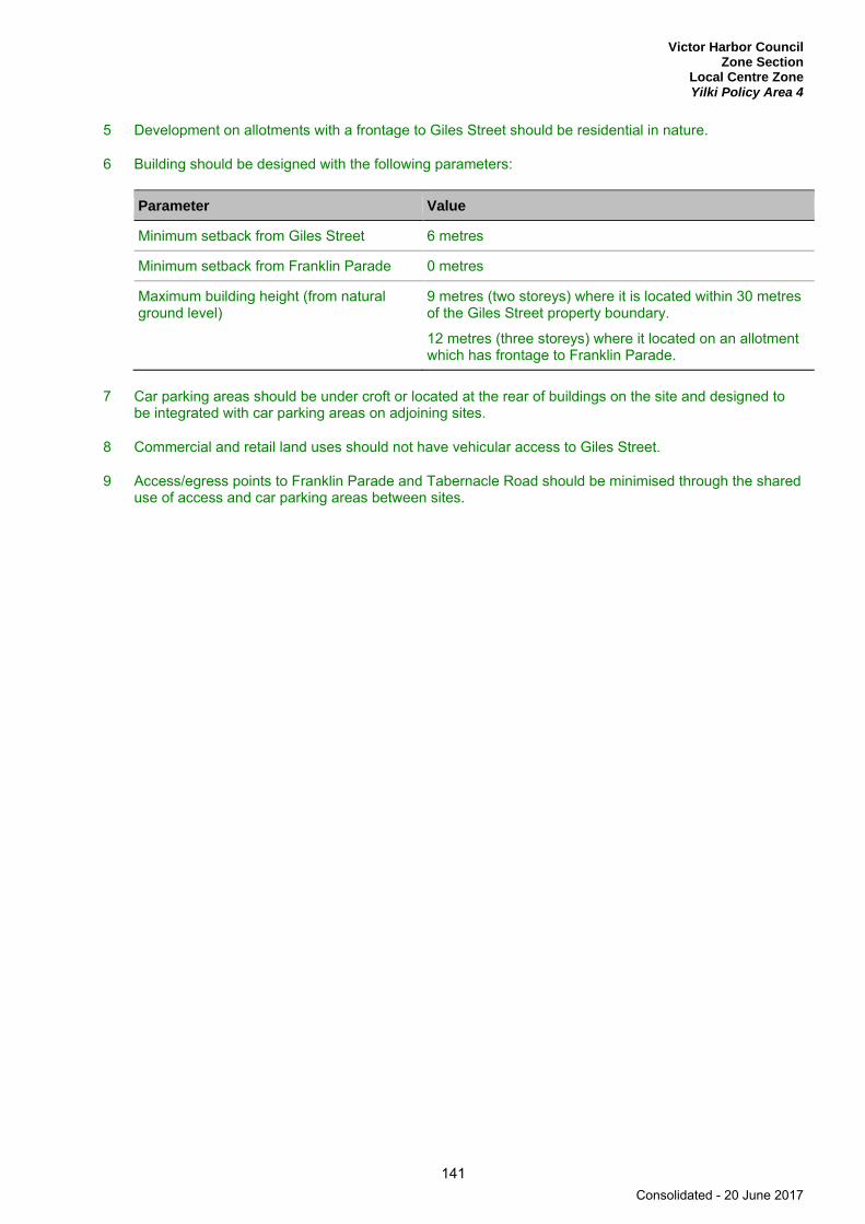
Victor Harbor Council Zone Section
Local Centre Zone Yilki Policy Area 4
141
5 Development on allotments with a frontage to Giles Street should be residential in nature.
6 Building should be designed with the following parameters:
Parameter Value
Minimum setback from Giles Street 6 metres
Minimum setback from Franklin Parade 0 metres
Maximum building height (from natural ground level)
9 metres (two storeys) where it is located within 30 metres of the Giles Street property boundary.
12 metres (three storeys) where it located on an allotment which has frontage to Franklin Parade.
7 Car parking areas should be under croft or located at the rear of buildings on the site and designed to be integrated with car parking areas on adjoining sites.
8 Commercial and retail land uses should not have vehicular access to Giles Street.
9 Access/egress points to Franklin Parade and Tabernacle Road should be minimised through the shared use of access and car parking areas between sites.
Consolidated - 20 June 2017
Victor Harbor Council Zone Section Local Centre Zone
142
PROCEDURAL MATTERS
Complying Development Complying developments are prescribed in Schedule 4 of the Development Regulations 2008.
In addition, the following forms of development (except where the development is non-complying) are complying:
A change of use to a shop, office, consulting room or any combination of these uses where all of the following are achieved:
(a) the area to be occupied by the proposed development is located in an existing building and is currently used as a shop, office, consulting room or any combination of these uses
(b) the building is not a State heritage place
(c) it will not involve any alterations or additions to the external appearance of a local heritage place as viewed from a public road or public space
(d) if the proposed change of use is for a shop that primarily involves the handling and sale of foodstuffs, it achieves either (i) or (ii):
(i) all of the following:
(A) areas used for the storage and collection of refuse are sited at least 10 metres from any Residential Zone boundary or a dwelling (other than a dwelling directly associated with the proposed shop)
(B) if the shop involves the heating and cooking of foodstuffs in a commercial kitchen and is within 30 metres of any Residential Zone boundary or a dwelling (other than a dwelling directly associated with the proposed shop), an exhaust duct and stack (chimney) exists or is capable of being installed for discharging exhaust emissions
(ii) the development is the same or substantially the same as a development, which has previously been granted development approval under the Development Act 1993 or any subsequent Act and Regulations, and the development is to be undertaken and operated in accordance with the conditions attached to the previously approved development
(e) if the change in use is for a shop with a gross leasable floor area greater than 250 square metres and has direct frontage to an arterial road, it achieves either (i) or (ii):
(i) the primary vehicle access (being the access where the majority of vehicles access / egress the site of the proposed development) is from a road that is not an arterial road
(ii) the development is located on a site that operates as an integrated complex containing two or more tenancies (and which may comprise more than one building) where facilities for off-street vehicle parking, vehicle loading and unloading, and the storage and collection of refuse are shared
(f) off-street vehicular parking is provided in accordance with the rate(s) specified in Table ViH/2 - Off Street Vehicle Parking Requirements and Table ViH/3 - Off Street Bicycle Parking Requirements to the nearest whole number, except in any one of more of the following circumstances:
(i) the building is a local heritage place
(ii) the development is the same or substantially the same as a development, which has previously been granted development approval under the Development Act 1993 or any subsequent Act and Regulations, and the number and location of parking spaces is the same or substantially the same as that which was previously approved.
Consolidated - 20 June 2017

Victor Harbor Council Zone Section
Local Centre Zone
143
Non-complying Development Development (including building work, a change in the use of land, or division of an allotment) for the following is non-complying:
Form of development Exceptions
Development which is located on an allotment which has frontage to Giles Street
Except where the development is a dwelling or it is associated with and ancillary to a dwelling.
Dwelling Except where it achieves one of the following: (a) it is located on an allotment which does not have
frontage to Franklin Parade or Giles Street and it is developed in conjunction with a non-residential development
(b) it is located on an allotment which has frontage to Franklin Parade and it is located above or behind a non-residential land use
(c) it is located on an allotment which has frontage to Giles Street.
Fuel depot
Horticulture
Industry
Intensive animal keeping
Motor repair station
Petrol filling station
Public service depot
Residential flat building Except where in conjunction with a non-residential development.
Road transport terminal
Service trade premises
Store
Warehouse
Waste reception, storage, treatment or disposal
Wrecking yard
Public Notification Categories of public notification are prescribed in Schedule 9 of the Development Regulations 2008.
Consolidated - 20 June 2017

Victor Harbor Council Zone Section Mixed Use Zone
144
Mixed Use Zone
Refer to the Map Reference Tables for a list of the maps that relate to this zone.
OBJECTIVES
1 A functional and diverse zone accommodating a mix of commercial, community, medium density residential, office, and small-scale shop land uses.
2 Development that minimises any adverse impacts upon the amenity of the locality within the zone.
3 Development that contributes to the desired character of the zone.
DESIRED CHARACTER
The zone provides for a wide range of development but emphasis is placed on activities with a low impact such as community services, residential development and educational facilities.
Vegetated areas, particularly adjacent the Inman River, will be retained for open space and recreational purposes. Legible and safe pedestrian paths will be provided around and through the site to the riverine environment.
Access / egress to the site will be via Ewen Terrace and Armstrong Road, however, the access from Armstrong Road will provide a no-through road arrangement that services uses fronting that road.
The vegetated council drain along Armstrong Road will be retained and provide screening to the emergency services precinct. Emergency service activities will be protected from encroachment by adjoining uses that would otherwise restrict their activities.
Development will not occur within a 1-in-100 year average return interval flood event area. Development will seek opportunities for harvesting and recycling of stormwater and will ensure that pollutants are not transferred to the river system.
PRINCIPLES OF DEVELOPMENT CONTROL
Land Use 1 The following forms of development are envisaged in the zone:
▪ affordable housing▪ aged persons accommodation▪ community facility▪ consulting room▪ educational establishment▪ emergency services facility▪ group dwelling▪ institutional facility▪ multiple dwelling▪ office▪ residential flat building▪ row dwelling▪ shop or group of shops where the maximum gross leasable area is in the order of 250 square
metres
Consolidated - 20 June 2017
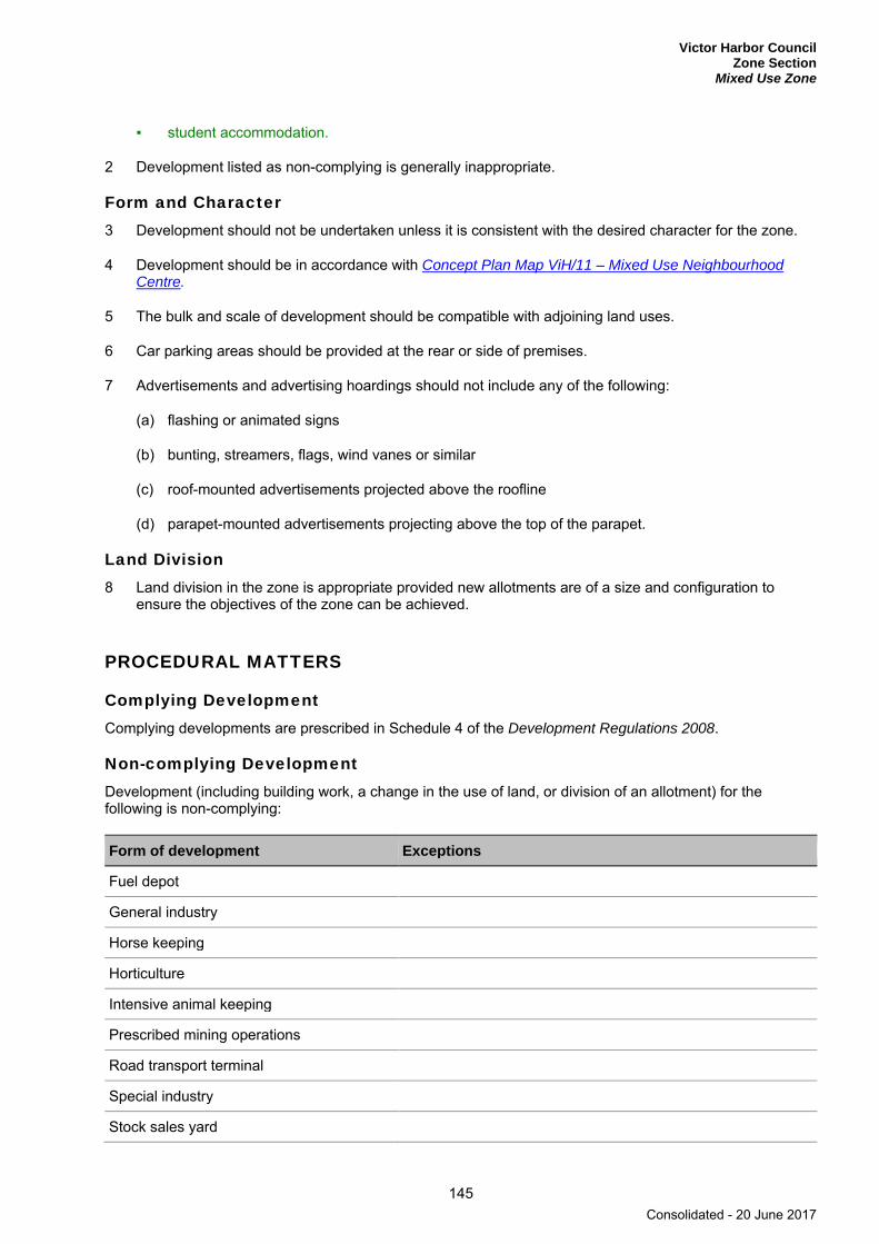
Victor Harbor Council Zone Section
Mixed Use Zone
145
▪ student accommodation.
2 Development listed as non-complying is generally inappropriate.
Form and Character 3 Development should not be undertaken unless it is consistent with the desired character for the zone.
4 Development should be in accordance with Concept Plan Map ViH/11 – Mixed Use Neighbourhood Centre.
5 The bulk and scale of development should be compatible with adjoining land uses.
6 Car parking areas should be provided at the rear or side of premises.
7 Advertisements and advertising hoardings should not include any of the following:
(a) flashing or animated signs
(b) bunting, streamers, flags, wind vanes or similar
(c) roof-mounted advertisements projected above the roofline
(d) parapet-mounted advertisements projecting above the top of the parapet.
Land Division 8 Land division in the zone is appropriate provided new allotments are of a size and configuration to
ensure the objectives of the zone can be achieved.
PROCEDURAL MATTERS
Complying Development Complying developments are prescribed in Schedule 4 of the Development Regulations 2008.
Non-complying Development Development (including building work, a change in the use of land, or division of an allotment) for the following is non-complying:
Form of development Exceptions
Fuel depot
General industry
Horse keeping
Horticulture
Intensive animal keeping
Prescribed mining operations
Road transport terminal
Special industry
Stock sales yard
Consolidated - 20 June 2017

Victor Harbor Council Zone Section Mixed Use Zone
146
Form of development Exceptions
Stock slaughter works
Tourist accommodation
Waste reception, storage, treatment or disposal
Except where in the form of a recycling collection depot.
Wrecking yard
Public Notification Categories of public notification are prescribed in Schedule 9 of the Development Regulations 2008.
Further, the following forms of development (except where the development is non-complying) are designated:
Category 1 Category 2
Community facility
Consulting room
Dwelling
Office
Residential flat building
Shop or group of shops where the gross leasable area is 250 square metres or less.
Educational establishment
Emergency services facility
Shop, other than where designated as Category 1
Consolidated - 20 June 2017
Victor Harbor Council Zone Section
Neighbourhood Centre Zone
147
Neighbourhood Centre Zone
Refer to the Map Reference Tables for a list of the maps that relate to this policy area.
OBJECTIVES
1 A activity centre providing a range of shopping, community, businessand recreational facilities for the surrounding neighbourhood.
2 A activity centre that provides the main focus of business and community life outside of the Regional Centre Zone, and provides for the more frequent and regularly recurring needs of a community.
3 A activity centre accommodating residential development in conjunction with non-residential development.
4 An activity centre which has a safe and convenient environment for the movement of pedestrians, cyclists and vehicular traffic, within, to, and from the zone.
5 Development located and designed to minimise adverse impact and conflict between land uses, both within the zone and in adjoining areas.
6 Development that contributes to the desired character of the zone.
DESIRED CHARACTER
Development will be of a high architectural design standard and appearance that responds to and reinforces positive aspects of the local environment and built form. Active frontages will be promoted through the frequency of different tenancies, diversity of activities, a high proportion of windows and numerous pedestrian entrances. Verandas will be provided to create a comfortable and intimate place for pedestrians and large blank walls will be avoided. A consistent landscaping approach will be employed in each activity centre location to provide a unified, linking aspect over the various land uses.
The activity centres at McCracken and Hayborough occupy prominent locations and, as such, it is important that built form and associated advertisements do not overwhelm the respective localities. This will be achieved through the appropriate siting of taller buildings (or taller elements of buildings), use of setbacks from roadways (including a minimum of 3 metre setback from both Adelaide and Hindmarsh roads) and adjacent residential sites, landscaping of all frontages to soften built form, and the use of colours and materials.
Hayborough Area Development of the Hayborough Area of the Neighbourhood Centre Zone will be undertaken in accordance with Concept Plan Map ViH/ 12 – Neighbourhood Centre (Hayborough). Stand-alone residential dwellings may be developed fronting March Avenue, however, all other residential development in the Hayborough Area will be in conjunction with non-residential development.
McCracken Area Development of the McCracken Area of the Neighbourhood Centre Zone will be undertaken in accordance with Concept Plan Map ViH/ 13 – Neighbourhood Centre (McCracken). The primary vehicular access to commercial activities will be via the Adelaide / Hindmarsh / Port Elliot roundabout and from Adelaide Road, with appropriate vehicular access also provided from McCracken Drive.
Consolidated - 20 June 2017

Victor Harbor Council Zone Section Neighbourhood Centre Zone
148
PRINCIPLES OF DEVELOPMENT CONTROL
Land Use 1 The following forms of development are envisaged in the zone:
▪ bank▪ bulky goods outlet▪ child care facility▪ consulting room▪ dwelling in conjunction with non-residential land use▪ library▪ health centre▪ office▪ petrol filling station▪ place of worship▪ playing field▪ pre-school▪ primary school▪ recreation area▪ restaurant▪ shop▪ supermarket▪ tourist accommodation with no gaming or public bar facilities.
2 Development listed as non-complying is generally inappropriate.
3 Development should be undertaken in accordance with Concept Plan Map ViH/ 12 – Neighbourhood Centre (Hayborough) and Concept Plan Map ViH/ 13 – Neighbourhood Centre (McCracken).
4 Development comprising a variety of residential and non-residential uses should only be undertaken if such development does not prejudice the operation of existing or future non-residential activity within the zone.
5 Dwellings should be located only behind or above non-residential uses on the same allotment other than:
(a) within the Hayborough Area where residential development has direct frontage to March Avenue
(b) within the McCracken Area where residential development is envisaged within the southern portion of the site as per Concept Plan Map ViH/ 13 – Neighbourhood Centre (McCracken).
Form and Character 6 Development should not be undertaken unless it is consistent with the desired character for the zone.
7 Buildings should:
(a) not exceed three storeys (or 12 metres in height) above existing natural ground level
(b) be orientated towards the street and not turn its back on the public domain
(c) have setbacks from street boundaries to cater for appropriate car parking, access, manoeuvring and landscaped areas.
8 Outdoor advertisements attached to buildings should only be erected in the zone where they are attached to the building and are below the ridgeline of the supporting building.
9 Development should be sited and designed to minimise negative impacts on existing and potential future land uses desired in the locality.
Consolidated - 20 June 2017
Victor Harbor Council Zone Section
Neighbourhood Centre Zone
149
10 Residential development adjacent to non-residential land uses should be located, designed and/or sited to protect residents from potential adverse impacts from non-residential activities.
Interface 11 Development should mitigate interface impacts that are likely to adversely affect nearby residential uses
and general amenity in adjoining zones. This can be achieved by:
(a) utilising noise attenuation devices and building design to minimise the emission and effect of noise
(b) providing visual relief by way of landscaping on the perimeter of the site and within vehicle parking areas
(c) utilising air pollution control measures to prevent unreasonable interference with local amenity
(d) locating waste collection and storage areas away from the boundary with adjacent zones and within specially designed enclosures
(e) amending hours of operation
(f) siting and designing lighting to avoid overspill to adjoining properties.
Freestanding Advertisements 12 Freestanding advertisements and / or advertising hoardings for multiple-business tenancy complexes
should:
(a) be a maximum of 8 metres in height from the natural ground level
(b) incorporate the name or nature of each business or activity within the site or complex in a single advertisement.
Land Division 13 Land division in the zone is appropriate provided new allotments are of a size and configuration to
ensure the objectives of the zone can be achieved.
PROCEDURAL MATTERS
Complying Development Complying developments are prescribed in Schedule 4 of the Development Regulations 2008.
In addition, the following forms of development (except where the development is non-complying) are complying:
A change of use to a shop, office, consulting room or any combination of these uses where all of the following are achieved:
(a) the area to be occupied by the proposed development is located in an existing building and is currently used as a shop, office, consulting room or any combination of these uses
(b) the building is not a State heritage place
(c) it will not involve any alterations or additions to the external appearance of a local heritage place as viewed from a public road or public space
(d) if the proposed change of use is for a shop that primarily involves the handling and sale of foodstuffs, it achieves either (i) or (ii):
Consolidated - 20 June 2017
Victor Harbor Council Zone Section Neighbourhood Centre Zone
150
(i) all of the following:
(A) areas used for the storage and collection of refuse are sited at least 10 metres from any Residential Zone boundary or a dwelling (other than a dwelling directly associated with the proposed shop)
(B) if the shop involves the heating and cooking of foodstuffs in a commercial kitchen and is within 30 metres of any Residential Zone boundary or a dwelling (other than a dwelling directly associated with the proposed shop), an exhaust duct and stack (chimney) exists or is capable of being installed for discharging exhaust emissions
(ii) the development is the same or substantially the same as a development, which has previously been granted development approval under the Development Act 1993 or any subsequent Act and Regulations, and the development is to be undertaken and operated in accordance with the conditions attached to the previously approved development
(e) if the change in use is for a shop with a gross leasable floor area greater than 250 square metres and has direct frontage to an arterial road, it achieves either (i) or (ii):
(i) the primary vehicle access (being the access where the majority of vehicles access / egress the site of the proposed development) is from a road that is not an arterial road
(ii) the development is located on a site that operates as an integrated complex containing two or more tenancies (and which may comprise more than one building) where facilities for off-street vehicle parking, vehicle loading and unloading, and the storage and collection of refuse are shared
(f) off-street vehicular parking is provided in accordance with the rate(s) specified in Table ViH/2 - Off Street Vehicle Parking Requirements and Table ViH/3 - Off Street Bicycle Parking Requirements to the nearest whole number, except in any one of more of the following circumstances:
(i) the building is a local heritage place
(ii) the development is the same or substantially the same as a development, which has previously been granted development approval under the Development Act 1993 or any subsequent Act and Regulations, and the number and location of parking spaces is the same or substantially the same as that which was previously approved
(iii) the development is located on a site that operates as an integrated complex containing two or more tenancies (and which may comprise more than one building) where facilities for off-street vehicle parking, vehicle loading and unloading, and the storage and collection of refuse are shared.
Non-complying Development Development (including building work, a change in the use of land, or division of an allotment) for the following is non-complying:
Form of development Exceptions
Dwelling Except where one of the following applies: (a) it is developed in conjunction with a non-residential
development (b) it is located within the McCracken area as shown on Concept
Plan Map ViH/ 13 – Neighbourhood Centre (McCracken) and it is located south of a line formed along the centre line of the Port Elliot Road reserve between Wilkinson Avenue and Yandra Terrace that is extended through the McCracken Area
(c) it is located within the Hayborough Area as shown on Concept Plan Map ViH/ 12 – Neighbourhood Centre (Hayborough).
Consolidated - 20 June 2017

Victor Harbor Council Zone Section
Neighbourhood Centre Zone
151
Form of development Exceptions
Fuel depot
Horticulture
Industry
Major public service depot
Motor repair station
Residential flat building Except where in conjunction with a non-residential development.
Road transport terminal
Store
Warehouse
Waste reception, storage, treatment or disposal
Wrecking yard
Public Notification Categories of public notification are prescribed in Schedule 9 of the Development Regulations 2008.
Consolidated - 20 June 2017
Victor Harbor Council Zone Section Open Space Zone
152
Open Space Zone
Refer to the Map Reference Tables for a list of the maps that relate to this zone.
OBJECTIVES
1 Provision for community, recreational and conservation uses of land for the local and visiting population.
2 A zone:
(a) in which the open space character is preserved to provide a visual contrast to the surrounding urban area
(b) comprising open space that accommodates a range of public and private activities in an open and natural setting, including:
(i) passive and active recreation land uses
(ii) habitat conservation and restoration.
3 A linear park that:
(a) provides an open space corridor across Regional South Australia.
(b) promotes the use, awareness and preservation of the riverine environment and enhancement of natural or semi natural habitats for the movement of wildlife and conservation of biodiversity.
4 Preservation of the estuary environment in a natural state, and recognition of the unsuitability of flood-prone land for development.
5 A river system which provides for the maintenance of stormwater capacity and flood mitigation measures for adjoining areas.
6 The establishment of tourist accommodation facilities in conjunction with the Victor Harbor Golf Course.
7 Development that contributes to the desired character of the zone.
DESIRED CHARACTER
The zone provides for the establishment and maintenance of a network of open spaces and corridors based on the natural drainage pattern of the Council area.
The zone has a natural open character based on the conserved natural resources (watercourses, associated floodplains and riparian vegetation) and recreational land use functions. Development within the zone is allowed where it is associated with these envisaged functions, including the expansion the existing TAFE SA, Investigator College and Victor Harbor High School campuses. Additional land uses are confined to Golf Course Policy Area 5.
Consolidated - 20 June 2017

Victor Harbor Council Zone Section
Open Space Zone
153
PRINCIPLES OF DEVELOPMENT CONTROL
Land Use 1 The following forms of development are envisaged in the zone:
▪ conservation work ▪ educational establishment ▪ lighting ▪ outbuilding associated with open space maintenance ▪ playground ▪ recreation area ▪ sporting club facility ▪ structure associated with a public facility such as car parking, picnic/barbeque area, shelter and
toilet ▪ toilet block and barbeque facility.
2 Development listed as non-complying is generally inappropriate.
3 Publicly owned land should be used for any of the following:
(a) to provide natural or landscaped open space using locally indigenous plant species
(b) to accommodate a range of public recreation, sporting and institutional facilities and uses
(c) to accommodate stormwater retention and management
(d) to conserve and restore areas of remnant native vegetation and wildlife habitats and corridors
(e) to conserve sites of scientific, cultural or heritage interest
(f) for revegetation purposes using locally indigenous plant species
(g) to provide a buffer to adjoining areas of conservation significance.
4 Privately owned land should be used for any of the following:
(a) rural activities and agriculture (but not intensive animal keeping)
(b) low-impact sporting facilities
(c) conservation purposes.
5 Development should allow for unstructured passive and active recreation.
Form and Character 6 Development should not be undertaken unless it is consistent with the desired character for the zone.
7 Development should only occur where it is integral to the aesthetic, drainage or recreation function of the zone.
8 Buildings should be:
(a) restricted in size and number
(b) sited so as not to detract from the open natural character of the zone
(c) constructed of materials which blend with the riverine landscape.
Consolidated - 20 June 2017

Victor Harbor Council Zone Section Open Space Zone
154
9 Development should ensure coordinated design with an emphasis on the creation of pedestrian areas.
10 The natural features of the Inman River and Hindmarsh River estuaries should be conserved.
11 Landscaped buffers should be provided around the perimeter of recreation or sporting facilities.
12 Landscaping should comprise locally indigenous species and incorporate existing remnant vegetation.
13 Development, landscaping, and paths for pedestrians and cyclists should:
(a) take into account the changing flow regime and width of waterways
(b) be constructed of permeable material where practical to reduce stormwater runoff.
Land Division 14 Land division should not be undertaken except where:
(a) it will facilitate the development of an envisaged uses in the zone or policy area
(b) no additional allotments are created.
Consolidated - 20 June 2017

Victor Harbor Council Zone Section
Open Space Zone Golf Course Policy Area 5
155
Golf Course Policy Area 5
Refer to the Map Reference Tables for a list of the maps that relate to this policy area.
OBJECTIVES
1 A policy area comprising the Victor Harbor Golf Course and associated tourist accommodation facilities designed to integrate with areas of open space and the rural backdrop to the city.
PRINCIPLES OF DEVELOPMENT CONTROL
Land Use 1 The following forms of development are envisaged in the policy area in addition to the zone:
▪ car parking ▪ clubroom associated with a recreation facility ▪ golf course ▪ office associated with recreation facility ▪ shops or groups of shops ancillary to recreation facility ▪ tourist accommodation ▪ tourist development.
2 Development listed as non-complying is generally inappropriate.
3 Development associated with the Victor Harbor Golf Course should be sited and designed so that its profile sits below the ridge top when viewed from the township and does not detract from the open natural character of the policy area.
4 A shop or group of shops should only be developed where:
(a) it is in association with and ancillary to a recreational use
(b) the total gross leasable area is less than 450 square metres.
Form and Character 5 Development should be compatible with conservation and enhancement of the river environment.
Consolidated - 20 June 2017
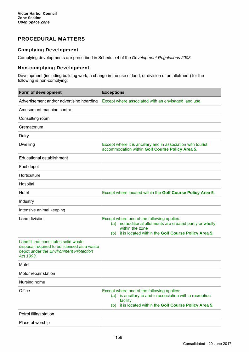
Victor Harbor Council Zone Section Open Space Zone
156
PROCEDURAL MATTERS
Complying Development Complying developments are prescribed in Schedule 4 of the Development Regulations 2008.
Non-complying Development Development (including building work, a change in the use of land, or division of an allotment) for the following is non-complying:
Form of development Exceptions
Advertisement and/or advertising hoarding Except where associated with an envisaged land use.
Amusement machine centre
Consulting room
Crematorium
Dairy
Dwelling Except where it is ancillary and in association with tourist accommodation within Golf Course Policy Area 5.
Educational establishment
Fuel depot
Horticulture
Hospital
Hotel Except where located within the Golf Course Policy Area 5.
Industry
Intensive animal keeping
Land division Except where one of the following applies: (a) no additional allotments are created partly or wholly
within the zone (b) it is located within the Golf Course Policy Area 5.
Landfill that constitutes solid waste disposal required to be licensed as a waste depot under the Environment Protection Act 1993.
Motel
Motor repair station
Nursing home
Office Except where one of the following applies: (a) is ancillary to and in association with a recreation
facility (b) it is located within the Golf Course Policy Area 5.
Petrol filling station
Place of worship
Consolidated - 20 June 2017
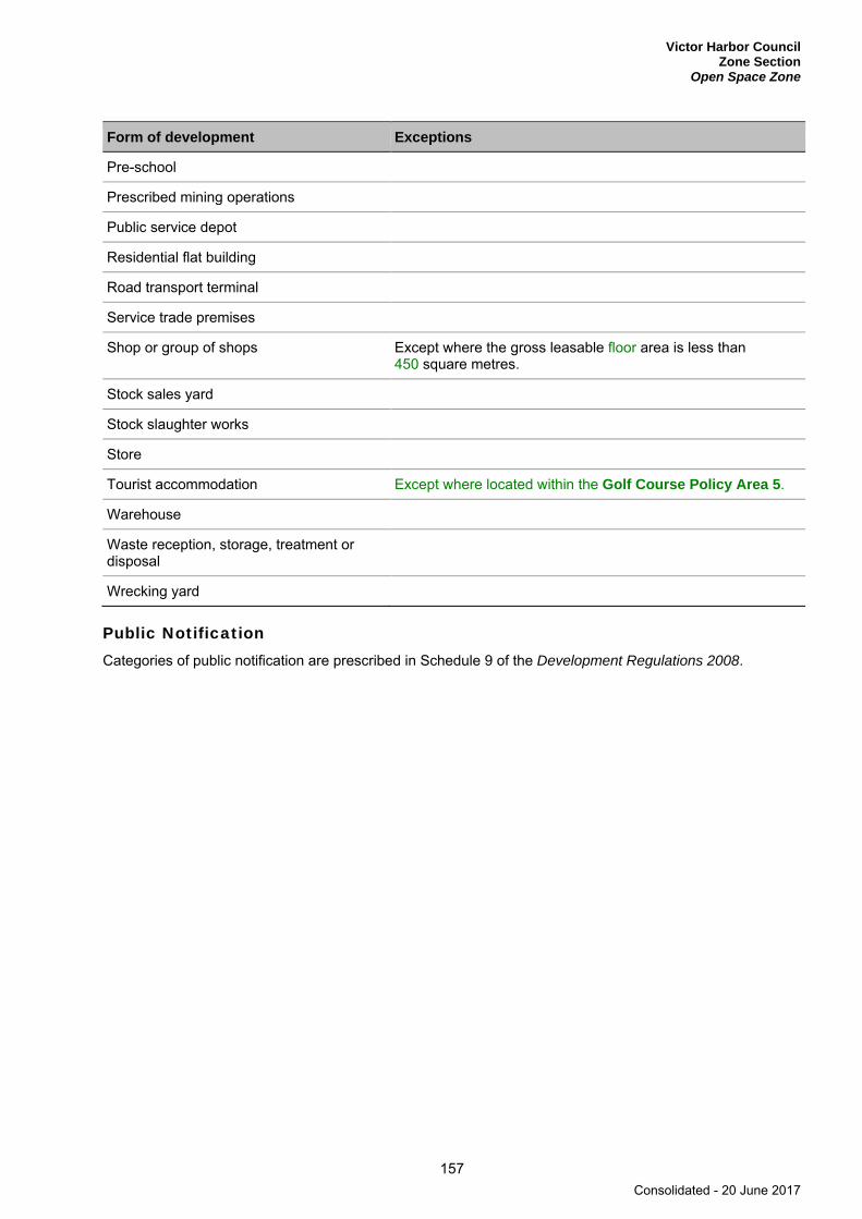
Victor Harbor Council Zone Section
Open Space Zone
157
Form of development Exceptions
Pre-school
Prescribed mining operations
Public service depot
Residential flat building
Road transport terminal
Service trade premises
Shop or group of shops Except where the gross leasable floor area is less than 450 square metres.
Stock sales yard
Stock slaughter works
Store
Tourist accommodation Except where located within the Golf Course Policy Area 5.
Warehouse
Waste reception, storage, treatment or disposal
Wrecking yard
Public Notification Categories of public notification are prescribed in Schedule 9 of the Development Regulations 2008.
Consolidated - 20 June 2017
Victor Harbor Council Zone Section Primary Production (Mount Lofty Ranges) Zone
158
Primary Production (Mount Lofty Ranges) Zone
Refer to the Map Reference Tables for a list of the maps that relate to this zone.
OBJECTIVES
1 The long term continuation of primary production.
2 Economically productive, efficient and environmentally sustainable primary production.
3 Allotments of a size and configuration that promote the efficient use of land for primary production.
4 Protection of primary production from encroachment by incompatible land uses and protection of scenic qualities of rural landscapes, including the outstanding landscape features of the land between the Cape Jervis to Victor Harbor Road and the southern coast, Glacier Rock and Spring Mount Conservation Park.
5 Development that contributes to the desired character of the zone.
DESIRED CHARACTER
This zone occupies a large proportion of the council area and consists of uses such as farming, horticulture, dairy, intensive animal keeping and commercial forestry. It is desirable not only that these activities continue, but also that good land management techniques be encouraged to control proclaimed pest plants, vermin, soil erosion and maintain water quality.
In order to improve the economy of the district and the viability of primary production units, ancillary value adding and agro-based industry, such as processing or handling of primary produce, is warranted. However, a large-scale proliferation of intensive development and occupation of the zone would threaten its proper function and render the rural landscape susceptible to competing demands, urbanisation and undesirable change. Incompatible development is to be restricted to support the ongoing function of primary production.
Tourism development will be small in scale and appropriate to the rural amenity and environment, including preservation of water quality. Larger tourism developments and related retail activities will remain primarily focused in townships and centres.
There is a considerable amount of significant native vegetation on private and public land. Buildings and structures on allotments which are wholly or partly covered in native vegetation will be designed and sited in a manner which requires the least area of vegetation to be cleared and the least fragmentation of homogenous areas of native vegetation. Development will revegetate denuded landscapes with indigenous vegetation.
Large allotments are to be maintained and amalgamations are encouraged to strengthen the viability of primary production land uses.
Ancillary development to primary production, including dwellings and outbuildings will be in appropriate locations to minimise visual and operational impacts on primary production activities.
Dwellings and other structures will be set well back from all boundaries, apart from within existing minor settlements where the existing pattern of development should be followed.
The public road network throughout the primary production areas will serve multiple functions as a freight network, tourist drives, droving of stock, people movement routes, transportation of farm machinery and as biodiversity corridors.
Consolidated - 20 June 2017

Victor Harbor Council Zone Section
Primary Production (Mount Lofty Ranges) Zone
159
The scenic qualities of the public routes and views across the zone will emphasise primary production and be unobstructed by inappropriate development, including excessive advertising signage. The nature and appearance of road reserves will vary across the primary production area depending on the role the road plays. Freight routes are to maintain wide, open reserves with limited driveway access points. Road reserves are to be kept clear of obstructions for the movement of farm machinery. Special tourist drives, particularly to conservation parks, will include vegetation corridors of biodiversity significance. Areas of conservation and biodiversity significance are to be protected from inappropriate development.
Development will be associated with existing clusters of buildings and will be of complementary scale and massing to those buildings, while also being of appropriate dimensions to serve their intended function. Development, including large sheds, will also be located and designed to blend with the existing landscape with appropriate earthworks and building design to suit the natural landform. Other structures will be of a form that blends with, and does not detract from, the scenic qualities and primary production function.
Development will maintain the rural landscape with buildings appropriately sited, designed and screened by vegetation. Buildings are to be constructed using materials and low-light reflective natural colours that blend with the rural landscape.
PRINCIPLES OF DEVELOPMENT CONTROL
Land Use 1 The following forms of development are envisaged in the zone:
▪ bulk handling and storage facility ▪ commercial forestry ▪ dairy farming ▪ farming ▪ horticulture ▪ intensive animal keeping ▪ on-farm rural produce sales ▪ tourist accommodation (including through the diversification of existing farming activities and
conversion of farm buildings).
2 Development listed as non-complying is generally inappropriate.
3 Industry and warehousing should only be developed if it supports primary production, the processing of organic waste or the processing, storage and distribution of local primary produce or products produced on the same site, and should be developed where:
(a) it has a direct relationship with primary production
(b) it is unlikely to limit or inhibit the use of adjoining land for primary production
(c) the particular use requires a site in proximity to a particular natural resource or other product or materials sourced from the locality
(d) it will not result in the alienation of land or water resources identified as significant for primary production or ecological reasons
(e) the use would be inappropriate within a township
(f) the capacity of the infrastructure, including roads, is capable of supporting the use without detriment to existing users.
4 A dwelling should only be developed if:
(a) there is a demonstrated connection with farming or other primary production
Consolidated - 20 June 2017

Victor Harbor Council Zone Section Primary Production (Mount Lofty Ranges) Zone
160
(b) the location of the dwelling will not inhibit the continuation of farming, other primary production or other development that is in keeping with the provisions of the zone
(c) it is located more than 500 metres from an existing intensive animal keeping operation unless used in association with that activity
(d) it does not result in more than one dwelling per allotment.
5 Tourist accommodation development should only occur where it achieves at least one of (a) or (b):
(a) it is within existing buildings
(b) it is an integral part of a farm complex in the form of at least 1 of the following:
(i) farm stay
(ii) guesthouse
(iii) rural or nature retreat
(iv) bed and breakfast accommodation.
6 Tourist accommodation should not be converted to dwellings and should be designed to preclude the conversion of buildings into dwellings such as through shared facilities, common utility services, grouped accommodation and/or shared parking.
7 A shop or group of shops should:
(a) be ancillary to and in association with a primary production or processing use, tourist accommodation or other tourist development
(b) be located on the same site as the primary use
(c) have a total gross leasable floor area of 250 square metres or less.
Form and Character 8 Development should not be undertaken unless it is consistent with the desired character for the zone.
9 Development should not occur within 500 metres of a National Park, Conservation Park, Wilderness Protection Area or significant stands of native vegetation if it will increase the potential for, or result in, the spread of pest plants.
10 Development should provide an access way of at least 3 metres wide that provides access for emergency vehicles to the rear of the allotment.
11 Buildings should primarily be limited to farm buildings, a detached dwelling associated with primary production on the allotment and residential outbuildings that are:
(a) grouped together on the allotment and set back from allotment boundaries to minimise the visual impact of buildings on the landscape as viewed from public roads
(b) screened from public roads and adjacent land by existing vegetation or landscaped buffers.
12 Dwellings on the hillside facing the Victor Harbor urban area should be single-storey in height or where they comprise two levels, are benched into the slope of the land to establish a low profile.
13 Buildings on the hillside facing the Victor Harbor urban area should not appear on or above the skyline but should be sited well below the ridge top.
Consolidated - 20 June 2017
Victor Harbor Council Zone Section
Primary Production (Mount Lofty Ranges) Zone
161
14 Dwellings, outbuildings, tanks and other structures on the hillside facing the Victor Harbor urban area should be grouped together to avoid scattered or random siting of structures.
15 Roads and driveways on the hillside facing the Victor Harbor urban area should be landscaped to minimise their visual impact.
16 To prevent visual intrusion on the escarpment, electricity and telephone lines located on the hillside facing the Victor Harbor urban area should be underground.
17 Fences located on the hillside facing the Victor Harbor urban area should be constructed of open mesh, post and wire or other materials which can be seen through and solid fences should not be erected.
On-farm Rural Produce Sales 18 On-farm sales of primary produce sourced from the subject allotment and/or processed on the subject
allotment may occur provided that:
(a) the retail ‘farm gate’ sales remain ancillary and incidental to the principal horticultural, farming or processing use of the land, and is not for the purpose of general retailing
(b) it occurs primarily within existing buildings or structures and where the location of the proposed activity will not result in an unreasonable impact on the amenity of habitable buildings on adjacent allotments
(c) the total area on the allotment for the sale and display of primary produce and/or related goods does not exceed 50 square metres
(d) where a new building is proposed it is sited within 15 metres of an existing dwelling or farm building on the allotment
(e) the design of the building or building addition is single storey and is not of a height greater than 5 metres above the natural ground level and has external materials which are in keeping with existing farm buildings
(f) the site has an existing direct access from a public road, such that no additional crossover in the road reserve is required to accommodate the use, and is connected to an internal access road:
(i) which allows for the forward entry and exit of all vehicles generated by the existing and proposed use of the allotment
(ii) which is designed, or can be easily modified without extensive excavation and or filling of the land, to accommodate the forward entry and exit of all vehicles generated by the existing and proposed use of the allotment
(g) there is sufficient area for on-site parking such that there is no increase in the risk of visitors parking in the road reserve arsing from traffic generated by the sale of goods on the land
(h) signage dimensions, overall height and the number of signs are designed and located to minimise undesirable impact on the visual amenity of the area and potential unreasonable impact on road or driver safety, and:
(i) may be in the form of a moveable or portable sign so that it is easily removed periodically, or when produce is not in season, or when trading does not occur
(ii) be integrated with an existing sign on the allotment provided the area of the advertisement does not exceed 2 square metres nor have a dimension greater than 2 metres
(iii) be an additional sign provided it does not result in more than two signs on the allotment and each sign has an advertisement area that does not exceed 2 square metres nor have a dimension greater than 2 metres
Consolidated - 20 June 2017
Victor Harbor Council Zone Section Primary Production (Mount Lofty Ranges) Zone
162
(iv) the finished height from ground level is not greater than 2.5 metres
(v) no fixed sign is constructed in a road reserve
(i) development involving new built form or hard paved parking or display areas includes native landscaping, appropriate to the site and locality, to enhance the appearance of the site.
Land Division 19 Land division should only occur if no additional allotments are created in association with one of the
following:
(a) the proposal is for a minor readjustment of allotment boundaries in order to correct an anomaly in the placement of those boundaries with respect to the location of existing buildings or structures
(b) the proposal is to alter the boundaries of an allotment in order to improve the management of the land for the purpose of primary production and/or the conservation of natural features.
Consolidated - 20 June 2017
Victor Harbor Council Zone Section
Primary Production (Mount Lofty Ranges) Zone Coastal Policy Area 6
163
Coastal Policy Area 6
Refer to the Map Reference Tables for a list of the maps that relate to this policy area.
OBJECTIVES
1 A policy area consisting of farming activities compatible with preservation of the natural coastal environment.
2 Retention and enhancement of areas with particular scientific, recreational and environmental quality and significance.
3 Protection of the visual qualities for the scenic coastal landscape, including the rocky cliffs, sandy beaches, dunes and estuaries and native vegetation.
4 Provision for enhancement and conservation of those locations and sites of particular tourist/recreational attraction, including Parsons/Waitpinga Beach, Petrel Cove, Rosetta Head and Rosetta Bay.
5 Land subject to inundation or susceptible to erosion kept free of development.
PRINCIPLES OF DEVELOPMENT CONTROL
Land Use 1 Development should be comprised primarily of agricultural land uses which are of an appropriate size
and scale to minimise the impact on the special environmental features of the coastal area.
2 Industrial or commercial development should only occur in this policy area where it is ancillary to and in association with the processing of primary production in the locality.
3 Development should be designed and sited to minimise its visual impact on the coast and retain the visual and environmental qualities of the coast.
4 Development should not be located on sand dunes or close to soft, erodible coastal cliffs.
5 Buildings should be located at least 400 metres from the high water mark.
6 Development should not be located on prominent sites on open land.
7 Where land is in view from the coast the most unobtrusive portion of the allotment should be used, preferably where existing vegetation will screen the development substantially. Wherever possible, an extensive tree planting scheme should be undertaken to screen any exposed views of the development and in all cases, the design of buildings should be, as far as possible:
(a) of a character and design which will blend with the surrounding landscapes
(b) incorporate low-pitched roofs of a non-reflective texture and natural earth colours, for example, green or brown
(c) have walls finished in natural colours with preference being given to brown or green finishes which will blend with the intended rural character of the zone
(d) involve excavations having a minimum detrimental effect on any vegetation on the site or the natural appearance of the zone
Consolidated - 20 June 2017
Victor Harbor Council Zone Section Primary Production (Mount Lofty Ranges) Zone Coastal Policy Area 6
164
(e) have fencing of non-reflective materials and of a design, height and colour that will not impair the surrounding landscape
(f) locate any access roads, driveways and associated excavations so as to cause minimum impairment to the natural appearance of the policy area.
Land Division 8 Land division should only be undertaken where no additional allotments are created wholly or partly
within the policy area and the purpose of the plan of division is to achieve one of the following:
(a) provide for a minor readjustment of allotment boundaries in order to correct an anomaly in the placement of these boundaries with respect to the location of existing buildings and structures
(b) provide for minor readjustment of allotment boundaries in order to improve the management of the land for the purpose of primary production and/or the conservation of its natural features.
Consolidated - 20 June 2017
Victor Harbor Council Zone Section
Primary Production (Mount Lofty Ranges) Zone
165
PROCEDURAL MATTERS
Complying Development Complying developments are prescribed in Schedule 4 of the Development Regulations 2008.
No other forms of development are complying in the zone.
Non-complying Development Development (including building work, a change in the use of land, or division of an allotment) for the following is non-complying:
Form of development Exceptions
Buildings within Coastal Policy Area 6
Where located greater than 400 metres from the high water mark.
All forms of development Complying Development as prescribed in Schedule 4 of the Development Regulations 2008.
Advertisement and/or advertising hoarding where the development achieves at least one of (a) or (b):
(a) is adjacent to a road with a speed limit of less than 80 km/h
(b) has an advertisement area of 2 square metres or less and achieves all of the following: (i) the message contained thereon relates entirely to a
lawful use of land (ii) the advertisement is erected on the same allotment
as the use it seeks to advertise (iii) the advertisement will not result in more than two
advertisements on the allotment.
Agricultural industry (including an ancillary area for sale and display of produce) that achieves all of the following criteria:
(a) at least one of the following activities associated with the processing of primary produce takes place: (i) washing (ii) grading (iii) processing (including bottling) (iv) packing or storage
(b) the total combined area for any one or any combination of these activities (including ancillary activities) does not exceed 250 square metres per allotment with a maximum total floor area of no greater than 150 square metres, including a maximum total floor area of 50 square metres for sale and display of goods manufactured in the industry
(c) the industry, including any ancillary uses, is located within the boundary of a single allotment
(d) there is no more than one industry located on an allotment (e) the industry is not located in areas subject to inundation
by a 100 year return period flood even or sited on land fill which would interfere with the flow of such waters
(f) the industry is connected to an approved effluent disposal scheme or has an on site waste water treatment and disposal method which complies with the requirements of the Environment Protection Authority
(g) the industry effluent system and any disposal areas are located within the allotment of the development
Consolidated - 20 June 2017
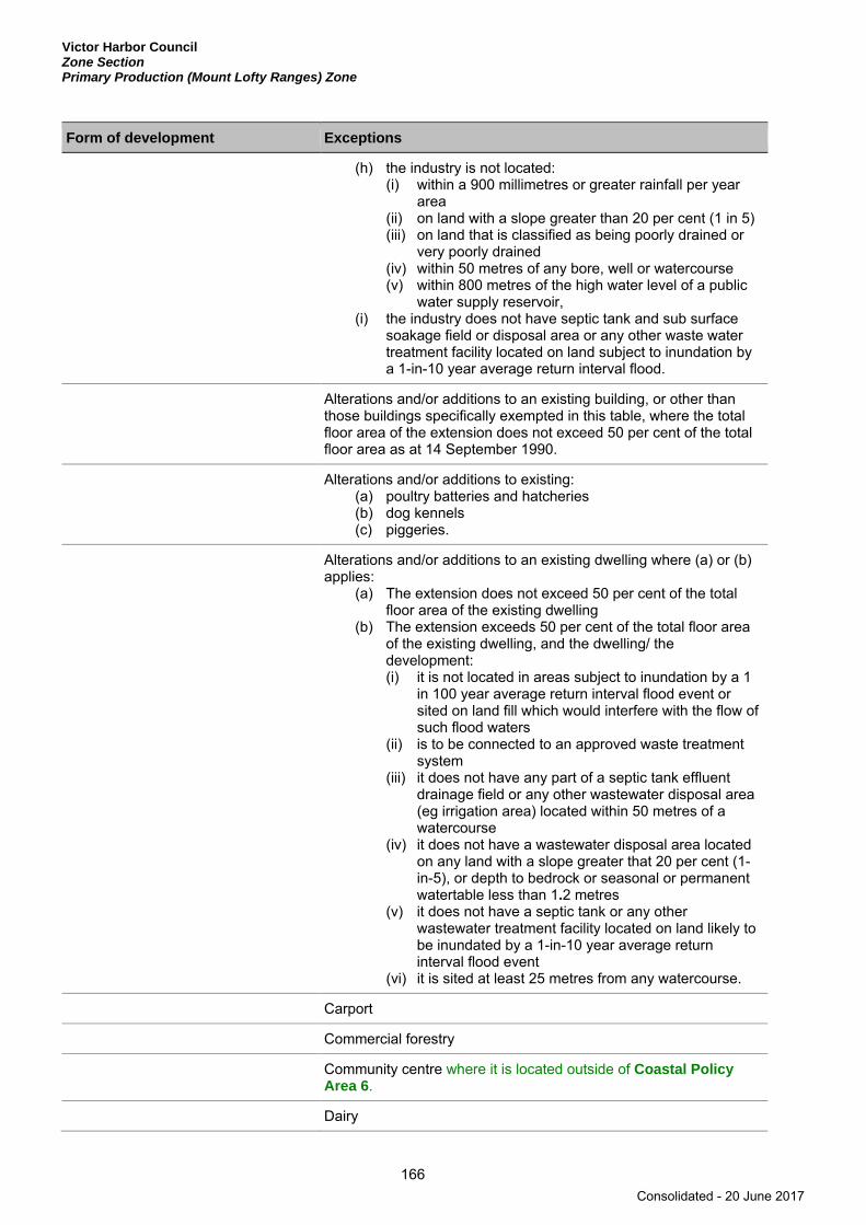
Victor Harbor Council Zone Section Primary Production (Mount Lofty Ranges) Zone
166
Form of development Exceptions
(h) the industry is not located: (i) within a 900 millimetres or greater rainfall per year
area (ii) on land with a slope greater than 20 per cent (1 in 5) (iii) on land that is classified as being poorly drained or
very poorly drained (iv) within 50 metres of any bore, well or watercourse (v) within 800 metres of the high water level of a public
water supply reservoir, (i) the industry does not have septic tank and sub surface
soakage field or disposal area or any other waste water treatment facility located on land subject to inundation by a 1-in-10 year average return interval flood.
Alterations and/or additions to an existing building, or other than those buildings specifically exempted in this table, where the total floor area of the extension does not exceed 50 per cent of the total floor area as at 14 September 1990.
Alterations and/or additions to existing: (a) poultry batteries and hatcheries (b) dog kennels (c) piggeries.
Alterations and/or additions to an existing dwelling where (a) or (b) applies:
(a) The extension does not exceed 50 per cent of the total floor area of the existing dwelling
(b) The extension exceeds 50 per cent of the total floor area of the existing dwelling, and the dwelling/ the development: (i) it is not located in areas subject to inundation by a 1
in 100 year average return interval flood event or sited on land fill which would interfere with the flow of such flood waters
(ii) is to be connected to an approved waste treatment system
(iii) it does not have any part of a septic tank effluent drainage field or any other wastewater disposal area (eg irrigation area) located within 50 metres of a watercourse
(iv) it does not have a wastewater disposal area located on any land with a slope greater that 20 per cent (1-in-5), or depth to bedrock or seasonal or permanent watertable less than 1.2 metres
(v) it does not have a septic tank or any other wastewater treatment facility located on land likely to be inundated by a 1-in-10 year average return interval flood event
(vi) it is sited at least 25 metres from any watercourse.
Carport
Commercial forestry
Community centre where it is located outside of Coastal Policy Area 6.
Dairy
Consolidated - 20 June 2017
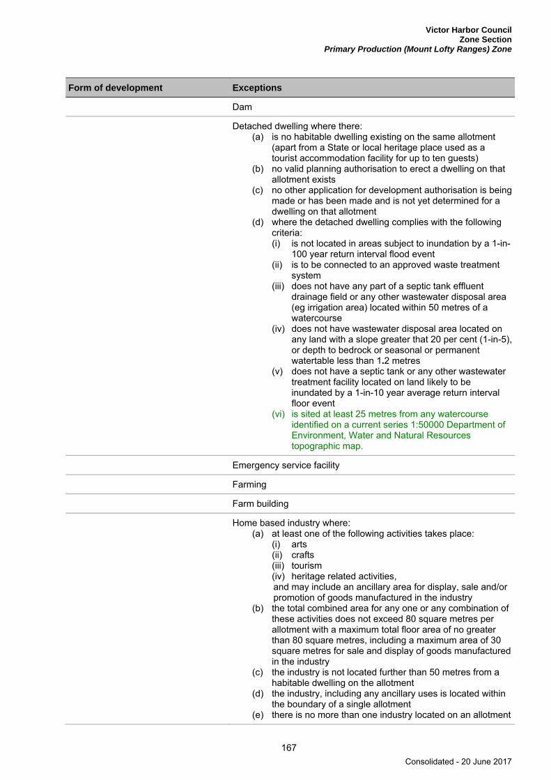
Victor Harbor Council Zone Section
Primary Production (Mount Lofty Ranges) Zone
167
Form of development Exceptions
Dam
Detached dwelling where there: (a) is no habitable dwelling existing on the same allotment
(apart from a State or local heritage place used as a tourist accommodation facility for up to ten guests)
(b) no valid planning authorisation to erect a dwelling on that allotment exists
(c) no other application for development authorisation is being made or has been made and is not yet determined for a dwelling on that allotment
(d) where the detached dwelling complies with the following criteria: (i) is not located in areas subject to inundation by a 1-in-
100 year return interval flood event (ii) is to be connected to an approved waste treatment
system (iii) does not have any part of a septic tank effluent
drainage field or any other wastewater disposal area (eg irrigation area) located within 50 metres of a watercourse
(iv) does not have wastewater disposal area located on any land with a slope greater that 20 per cent (1-in-5), or depth to bedrock or seasonal or permanent watertable less than 1.2 metres
(v) does not have a septic tank or any other wastewater treatment facility located on land likely to be inundated by a 1-in-10 year average return interval floor event
(vi) is sited at least 25 metres from any watercourse identified on a current series 1:50000 Department of Environment, Water and Natural Resources topographic map.
Emergency service facility
Farming
Farm building
Home based industry where: (a) at least one of the following activities takes place:
(i) arts (ii) crafts (iii) tourism (iv) heritage related activities, and may include an ancillary area for display, sale and/or promotion of goods manufactured in the industry
(b) the total combined area for any one or any combination of these activities does not exceed 80 square metres per allotment with a maximum total floor area of no greater than 80 square metres, including a maximum area of 30 square metres for sale and display of goods manufactured in the industry
(c) the industry is not located further than 50 metres from a habitable dwelling on the allotment
(d) the industry, including any ancillary uses is located within the boundary of a single allotment
(e) there is no more than one industry located on an allotment
Consolidated - 20 June 2017

Victor Harbor Council Zone Section Primary Production (Mount Lofty Ranges) Zone
168
Form of development Exceptions
(f) the industry is not located in areas subject to inundation by a 1-in-100 year average return interval flood or sited on land fill which would interfere with the flow of such flood waters
(g) the industry is connected to an approved sewerage effluent disposal scheme or has an on site waste water treatment and disposal method which complies with the requirements of the Environment Protection Authority
(h) the industry effluent system and any effluent drainage field is located within the allotment of the development
(i) the industry is not located: (i) on land with a slope greater than 20 per cent (1-in-5) (ii) on land that is classified as being poorly drained or
very poorly drained (iii) within 50 metres of any bore, well or watercourse (iv) within 200 metres of a major stream (3rd order or
higher), (j) the industry does not have a septic tank or any other
waste water treatment facility located on land subject to inundation by a 1-in-10 year average return interval flood.
Intensive animal keeping where it is located outside of Coastal Policy Area 6.
Land division where: (a) no additional allotments are created, either partly or
wholly, within the zone (b) the development of the proposed allotments does not
result in a greater risk of pollution of surface or underground waters that would the development of the existing allotments
(c) each resulting allotment provides a suitable site for a detached dwelling which complies with the following criteria: (i) is not located in areas subject to inundation by a 1-in-
100 year average return interval flood event or sited on land fill which would interfere with the flow of such flood waters
(ii) is to be connected to an approved waste treatment system.
(iii) does not have any part of a septic tank effluent drainage field or any other wastewater disposal area (eg irrigation area) located within 50 metres of a watercourse
(iv) does not have wastewater disposal area located on any land with a slope greater that 20 per cent (1-in-5), or depth to bedrock or seasonal or permanent watertable less than 1.2 metres
(v) does not have a septic tank or any other wastewater treatment facility located on land likely to be inundated by a 1-in-10 year average return interval flood
(vi) is sited at least 25 metres from any watercourse (d) it is located within Coastal Policy Area 6 and all resulting
allotments are located at least 200 metres of the coast.
Consolidated - 20 June 2017

Victor Harbor Council Zone Section
Primary Production (Mount Lofty Ranges) Zone
169
Form of development Exceptions
Mineral water extraction and processing plant where: (a) at least one of the following activities associated with the
extraction and processing of mineral water takes place: (i) extraction (ii) bottling (iii) packaging (iv) storage (v) distribution, and may include ancillary activities of administration and sale or promotion of mineral water product; and
(b) the total combined area for any one or any combination of these activities (including ancillary activities) does not exceed 350 square metres per allotment with a maximum total floor area of no greater than 250 square metres, including a maximum floor area of 50 square metres for the sale and display of goods manufactured in the industry
(c) the industry, including any ancillary uses, is located within the boundary of a single allotment
(d) there is no more than one industry located on an allotment (e) the industry is not located in areas subject to inundation
by a 1-in-100 year average return interval flood event or sited on land fill which would interfere with the flow of such flood waters
(f) the industry is connected to an approved sewage effluent disposal scheme or has an on site waste water treatment and disposal method which complies with the requirements of the Environment Protection Authority
(g) the industry effluent system and any effluent drainage field are located within the allotment of the development
(h) the building for bottling/packaging of mineral water for sale and distribution in refillable containers is not located: (i) on land with a slope greater than 20 per cent (1-in-5) (ii) on land that is classified as being poorly drained or
very poorly drained (iii) within 50 metres of any bore, well or watercourse (iv) within 200 metres of a major stream (3rd order or
higher), (i) the industry does not have a septic tank or any other
waste water treatment facility located on land subject to inundation by a 1-in-10 year average return intervalflood event
Office where ancillary to primary production or tourism development.
Consolidated - 20 June 2017

Victor Harbor Council Zone Section Primary Production (Mount Lofty Ranges) Zone
170
Form of development Exceptions
Organic waste processing facility where: (a) an impervious leachate barrier is provided between the
operational areas and the underlying soil and groundwater of an organic waste processing operation proposed to be located on a site that is wholly or partly within a water protection area
(b) the proposed organic waste processing operation is located on a site with ground slopes no greater than 6 per cent
(c) the proposed organic waste processing operation is located a minimum distance of 100 metres from any dam, river, creek, watercourse, channel or bore and not within the area of a 1-in-100 year average return interval flood event
(d) the proposed organic waste processing operation is located on land with a depth to subsurface seasonal tidal or permanent groundwater of 2 metres or greater
(e) the land to be used for the organic waste processing operation either (i) is at least 500 metres from the nearest sensitive
receptor, or (ii) the proposed organic waste processing operation
employs an in-vessel or fully enclosed composting system.
Outbuilding
Pergola
Public service depot
Recreation area including associated buildings and facilities.
Shop or group of shops where they are ancillary to and in association with a primary production or tourism development and they have a total floor area of 250 square metres or less.
Telecommunications facility below 30 metres in height.
Tourist accommodation and ancillary uses (not including caravan or camping grounds) where one of (a) to (e) applies and all of (f) to (l) applies:
(a) it is located within part of or as an extension to a dwelling or lawful tourist accommodation existing as at 14 September 1990, and where up to eight guests are accommodated in hosted accommodation
(b) it is located wholly within a dwelling or lawful tourist accommodation existing as at 21 September 2000, and where up to ten guests are accommodated in non-hosted accommodation
(c) it is located wholly within or within part of or as an extension to a State or local heritage place (which may be in association with a new or existing dwelling) and where no more than thirty guests are accommodated on a single allotment
(d) it is an integral part of a farm complex and it is in the form of at least one of the following: (i) farm stay (ii) guesthouse
Consolidated - 20 June 2017
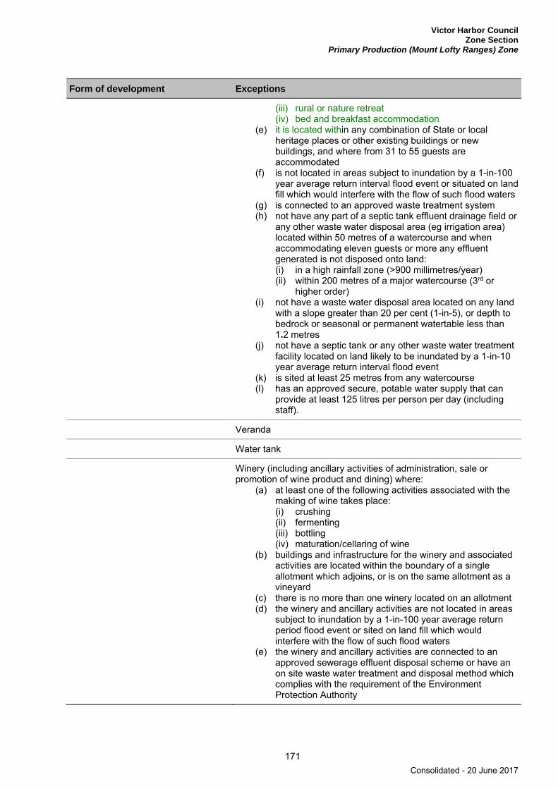
Victor Harbor Council Zone Section
Primary Production (Mount Lofty Ranges) Zone
171
Form of development Exceptions
(iii) rural or nature retreat (iv) bed and breakfast accommodation
(e) it is located within any combination of State or local heritage places or other existing buildings or new buildings, and where from 31 to 55 guests are accommodated
(f) is not located in areas subject to inundation by a 1-in-100 year average return interval flood event or situated on land fill which would interfere with the flow of such flood waters
(g) is connected to an approved waste treatment system (h) not have any part of a septic tank effluent drainage field or
any other waste water disposal area (eg irrigation area) located within 50 metres of a watercourse and when accommodating eleven guests or more any effluent generated is not disposed onto land: (i) in a high rainfall zone (>900 millimetres/year) (ii) within 200 metres of a major watercourse (3rd or
higher order) (i) not have a waste water disposal area located on any land
with a slope greater than 20 per cent (1-in-5), or depth to bedrock or seasonal or permanent watertable less than 1.2 metres
(j) not have a septic tank or any other waste water treatment facility located on land likely to be inundated by a 1-in-10 year average return interval flood event
(k) is sited at least 25 metres from any watercourse (l) has an approved secure, potable water supply that can
provide at least 125 litres per person per day (including staff).
Veranda
Water tank
Winery (including ancillary activities of administration, sale or promotion of wine product and dining) where:
(a) at least one of the following activities associated with the making of wine takes place: (i) crushing (ii) fermenting (iii) bottling (iv) maturation/cellaring of wine
(b) buildings and infrastructure for the winery and associated activities are located within the boundary of a single allotment which adjoins, or is on the same allotment as a vineyard
(c) there is no more than one winery located on an allotment (d) the winery and ancillary activities are not located in areas
subject to inundation by a 1-in-100 year average return period flood event or sited on land fill which would interfere with the flow of such flood waters
(e) the winery and ancillary activities are connected to an approved sewerage effluent disposal scheme or have an on site waste water treatment and disposal method which complies with the requirement of the Environment Protection Authority
Consolidated - 20 June 2017

Victor Harbor Council Zone Section Primary Production (Mount Lofty Ranges) Zone
172
Form of development Exceptions
(f) the winery and ancillary activities’ effluent system and any effluent drainage field are located within the allotment of the development
(g) the winery and ancillary activities are not located: (i) on land with a slope greater than 20 per cent (1-in-5) (ii) on land that is classified as being poorly drained or
very poorly drained (iii) within 50 metres of any bore, well or watercourse (iv) within 200 metres of a major stream (3rd order or
higher) (h) the winery extension and ancillary activities do not have a
septic or any other waste water treatment facility located on land subject to inundation by a 1-in-10 year average return period flood event.
Public Notification Categories of public notification are prescribed in Schedule 9 of the Development Regulations 2008.
Further, the following forms of development (except where the development is non-complying) are designated:
Category 1 Category 2
Agricultural Industry
Cellar door sales outlet
Demolition of elements of a Heritage Place identified in Table ViH/5 - State Heritage Places or in Table ViH/4 - Local Heritage Places.
Dwelling where both of the following apply: (a) it is to be established adjacent to an
allotment that contains a lawfully existing winery processing grapes or grape products exceeding the equivalent of a 500 tonne crush per annum
(b) it is to be established within 300 metres of any winery wastewater treatment equipment, effluent dam, building containing wine-making activities, and buildings containing bottling activities associated with a lawfully existing winery processing grapes or grape products exceeding the equivalent of a 500 tonne crush per annum.
Mineral water extraction and/or processing plant where bottling plants only use non refillable containers.
Restaurant
Shop where: (a) the tasting of wine and retail sale of wine
are the predominant activities (b) the sale and tasting of wine is limited to
that which is uniquely the licensee’s own product
Consolidated - 20 June 2017
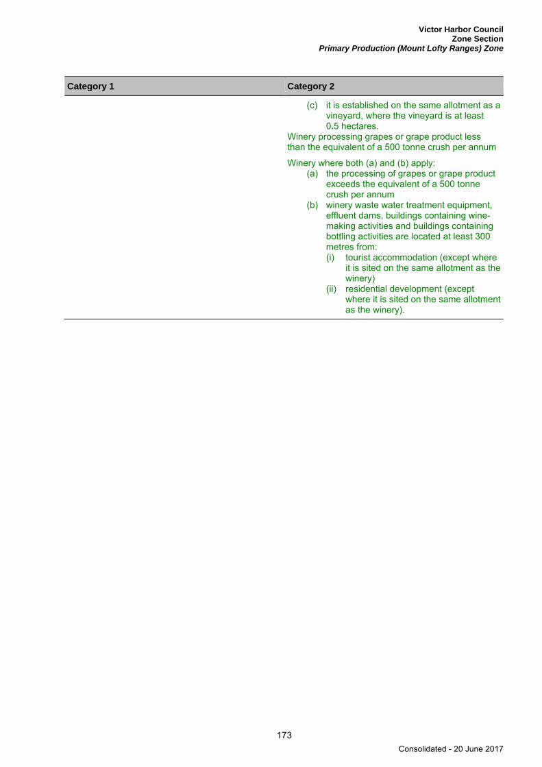
Victor Harbor Council Zone Section
Primary Production (Mount Lofty Ranges) Zone
173
Category 1 Category 2
(c) it is established on the same allotment as a vineyard, where the vineyard is at least 0.5 hectares.
Winery processing grapes or grape product less than the equivalent of a 500 tonne crush per annum
Winery where both (a) and (b) apply: (a) the processing of grapes or grape product
exceeds the equivalent of a 500 tonne crush per annum
(b) winery waste water treatment equipment, effluent dams, buildings containing wine-making activities and buildings containing bottling activities are located at least 300 metres from: (i) tourist accommodation (except where
it is sited on the same allotment as the winery)
(ii) residential development (except where it is sited on the same allotment as the winery).
Consolidated - 20 June 2017
Victor Harbor Council Zone Section Regional Centre Zone
174
Regional Centre Zone
Refer to the Map Reference Tables for a list of the maps that relate to this zone.
OBJECTIVES
1 A centre representing the primary focus for business and commercial services for the region providing a full range of shopping, administrative, cultural, community, entertainment, education, religious, tourist and recreational facilities, and public and private office development.
2 A centre providing a focus for public transport interchanges and networks.
3 Development of a visually and functionally cohesive and integrated regional centre.
4 A centre accommodating medium to high density residential development in conjunction with non-residential development.
5 Development that contributes to the desired character of the zone.
DESIRED CHARACTER
The zone will function as the primary regional service, business, retail, visitor and cultural focus for the southern Fleurieu Peninsula. The Centre will provide and expand upon the diversity of land uses available including retail, administrative, tourist and visitor, cultural, entertainment, community, business, educational and recreational facilities appropriate to the needs of the township and the rural and visitor catchments it serves. It will also accommodate medium to high density residential development in conjunction with non-residential development, for its residents and visitors. Residential development will not prejudice the operation of existing or future non-residential activity within the zone.
The character of the Regional Centre of Victor Harbor is principally derived from built form, infrastructure and landscapes relating to the cultural and historical associations of Victor Harbor as a prominent historical transport node linking rail and sea, a prominent seaside holiday destination, and, more recently, a regional centre. The coastal setting of Victor Harbor has, and will continue to play, an important role in influencing this character.
Historical buildings and infrastructure relating to the themes of early settlement, transport and leisure activities have a strong influence on the built form character of the Regional Centre. Conservation and reinforcement of the intimate and cohesive townscapes of Ocean Street, Coral Street, Railway Terrace and Burke Street, by protecting historic elements, improving existing features and ensuring new development is compatible with historic buildings and township character, particularly in relation to ‘fine grain’ façade patterns, verandas, balconies, fenestrations and signage.
Aspects that contribute to the Centre’s positive built form character include buildings with little or no side or front setbacks, verandas and balconies over footpaths, shop fronts with direct footpath interaction, buildings with a relatively high degree of articulation and detailing in their facades, simplicity in form, and consistent building scale. It is imperative that future development within the zone respects and complements the character and setting of heritage places.
Reserves and public recreation areas with established mature pines, palms and fig trees take advantage of the coastal location and will continue to ensure a high level of amenity. Strategic views from within the town centre to Granite Island, the causeway, Bluff and surrounding hills provides context and understanding of Victor Harbor’s identity as a regional coastal centre.
Consolidated - 20 June 2017

Victor Harbor Council Zone Section
Regional Centre Zone
175
Key ‘landmark’ sites are nominated within the zone or specific policy areas to provide the opportunity to expand upon the existing built form, adding to the vibrancy, liveliness and sustainability of the Regional Centre. The arrangement of development on Landmark Development Sites, limiting height at the street front and providing more substantial set-backs to upper levels will ensure that new buildings relate to the existing scale of built form in the town centre at street level. Development on these sites will be carefully designed to be sympathetic to Victor Harbor’s unique character.
Victor Harbor is a popular tourist destination with the Regional Centre being a tourist attraction in its own right. A significant focus for future development will be to improve the Centre as a vibrant and memorable holiday, seaside destination, providing both residential and visitor accommodation opportunities.
The Regional Centre will develop its movement system by providing an appropriate balance between ease of access, parking, high pedestrian connectivity, safety and amenity. Development will have emphasis on creating safe and attractive pedestrian networks with strong links to adjacent foreshore areas. Opportunities to develop new pedestrian connections involving land in public and private ownership are necessary to facilitate a fully integrated, permeable and cohesive centre as shown on Concept Plan Map ViH/3 - Regional Centre (Victor Harbor).
Development on land designated for the ‘Car Parking Fund Areas 1, 2 and 3’ as shown in Concept Plan ViH/2 - Car Parking Fund Areas will be subject to funding contributions for the purpose of providing appropriate car parking facilities within the Centre.
PRINCIPLES OF DEVELOPMENT CONTROL
Land Use 1 The following forms of development are envisaged in the zone:
▪ affordable housing ▪ bank ▪ child care centre ▪ civic centre ▪ consulting room ▪ department store ▪ dwelling in conjunction with non-residential development ▪ educational establishment ▪ emergency services facility ▪ entertainment facility ▪ health facility ▪ hospital ▪ hotel ▪ indoor games centre ▪ library ▪ motel ▪ motor repair station ▪ office ▪ place of worship ▪ playing field ▪ primary school ▪ pre-school ▪ public transport terminal ▪ residential flat building in conjunction with non-residential development ▪ restaurant ▪ shop ▪ supermarket ▪ swimming pool ▪ tourist facilities.
2 Development listed as non-complying is generally inappropriate.
Consolidated - 20 June 2017
Victor Harbor Council Zone Section Regional Centre Zone
176
3 Development comprising a variety of medium to high density residential (including affordable housing) and non-residential uses should only be developed if it does not prejudice the operation of existing or future non-residential activity within the zone.
Form and Character 4 Development should not be undertaken unless it is consistent with the desired character for the zone.
5 Development on allotments that front onto an ‘Active Street Frontage’ as shown on Concept Plan Map ViH/6 - Landmark Development Site (Regional Centre) should be designed to create an active ground floor street frontage and land use which encourages activity and interest for passing pedestrians, and contributes to the liveliness, vitality and security of public areas. To establish an active street frontage development should provide visual and/or physical contact between the street and the interior of the adjoining building.
6 Verandas should maintain a consistent alignment and be designed within the following parameters:
Street name Minimum Width from the building edge (Metres) Maximum Width from the building edge (Metres)
Ocean Street 3.5 on the eastern side 3.5 on the eastern side
3.2 on the western side 3.2 on the western side
Coral Street 3.4 on the northern side 3.5 on the northern side
3.4 on the southern side and reduced to 2.8 on the south eastern side to correspond with the established setback associated with the Grosvernor Hotel.
3.4 on the southern side
7 Verandas heights (to the underside of canopy or lowest projection) along Ocean Street and Coral Street may vary depending on the building height however, they should be designed within the following parameters:
Height of the Building Minimum Veranda Height (Metres) Maximum Veranda Height (Metres)
Single Storey 2.8 metres 3 metres
Double Storey 3 metres 3.5 metres
8 Except where specified in a particular policy area, development should be designed within the following parameters:
Parameter Value
Minimum setback from primary road frontage
0 metres or 10 metres for any portion of the building that exceeds 9 metres (two storeys) in height.
Minimum setback from side boundaries 0 metres
Maximum building height (from natural ground level)
9 metres (two storeys) or 10.5 metres (three storeys) where it is located on an allotment that fronts onto Ocean Street and the portion of the building which exceeds 9 metres (two storeys) in height is setback at least 10 metres from the road boundary.
9 Development should be designed and sited to promote linkages between the various developments within the centre and adjoining main roads.
Consolidated - 20 June 2017
Victor Harbor Council Zone Section
Regional Centre Zone
177
10 Facilities within the centre should be sited and designed with a view to promoting after-hours use to reinforce the centre as the focus of social activity in the region.
11 Development adjacent to residential development should be designed and sited to incorporate the following:
(a) noise attenuation devices and building design to minimise the emission and effect of noise
(b) landscaping on the perimeter of the site and within vehicle parking areas to provide visual relief
(c) service and plant facilities that are located away from the residential development.
12 Dwellings should be located only behind or above non-residential uses on the same allotment.
13 Development should occur in accordance with Concept Plan Map ViH/3 - Victor Harbor Regional Centre and Concept Plan Map ViH/6 - Landmark Development Sites (Regional Centre).
14 Car parking should be provided under or behind buildings so as not to be visible from the main street frontages.
15 Deck car parks should be integrated with adjoining development and developed in concealed areas or the areas marked ‘Proposed Decked Carpark’ on Concept Plan Map ViH/6 - Landmark Development Sites (Regional Centre).
Land Division 16 Land division, including the re-arrangement of existing allotment boundaries, should only occur where it
is required to achieve a co-ordinated development scheme or to rationalise land holdings to allow for development that is consistent with the objectives of the zone.
Consolidated - 20 June 2017
Victor Harbor Council Zone Section Regional Centre Zone Burke Street Character Policy Area 7
178
Burke Street Character Policy Area 7
Refer to the Map Reference Tables for a list of the maps that relate to this policy area.
OBJECTIVES
1 Development that conserves and enhances the cultural significance and historic character of identified places within the policy area.
2 Development within the policy area that is comprised primarily of single storey dwellings as well as small scale offices and consulting rooms.
3 Development that contributes to the desired character of the policy area.
DESIRED CHARACTER
The policy area provides an opportunity for existing dwellings to be converted to small scale commercial uses such as offices and consulting rooms, whilst ensuring the historic and cohesive character of the existing buildings is conserved.
Development is to be residential in appearance complementing the existing uniform single storey detached dwellings, primarily constructed after World War 1 to the later part of the 19th Century. Development will be designed and sited in a manner that will allow for the retention and enhancement of the character buildings and heritage places.
Development will retain the original street layout including rear access lanes and local roads. The streetscape will be enhanced by landscaped verges to complement front and side yard gardens achieved by providing building setbacks.
The implementation of traffic calming devices in Burke Street will not diminish the character of the original street network.
Open style construction front boundary fencing and low fencing (1.2 metres or less) is desired to maintain the view of heritage buildings and generous landscaping from public roads. Side fencing between front property boundaries and the building alignment will be the same construction as the front fence.
PRINCIPLES OF DEVELOPMENT CONTROL
Land Use 1 The following forms of development are envisaged in the policy area:
▪ bed and breakfast accommodation▪ consulting room▪ dwelling▪ office.
Form and Character 2 Development should not be undertaken unless it is consistent with the desired character for the policy
area.
3 Development should have a single storey appearance when viewed from the street to complement and reinforce the historic character of the policy area.
Consolidated - 20 June 2017
Victor Harbor Council Zone Section
Regional Centre Zone Burke Street Character Policy Area 7
179
4 Two storey development should only occur where it achieves all of the following:
(a) it is contained within the existing roof space or a minor extension to the rear of the roof space
(b) the overall building height, scale, form and setback patterns is compatible with existing single-storey development in the policy area.
5 New buildings should not be sited between the front street boundary and the façade of the existing dwelling.
6 Car parking areas for non residential uses should be located at the rear of the building on the site.
7 Fencing at the front of properties and forward of the main face of the dwelling should:
(a) be designed to complement the traditional period, style and form of the associated building
(b) be constructed of low timber pickets, low pier and plinth masonry or wrought iron
(c) be no more than 1.2 metres in height.
8 Rear and side boundary fencing that is located behind the main face of the dwelling should not exceed 1.8 metres in height.
9 Advertisements and advertising hoardings should:
(a) be of a size, colour, shape and materials that enhances the character of the locality
(b) not dominate or cause detraction from the historic value of the area.
Land Division 10 The division of land should only occur where it will maintain the traditional pattern and scale of existing
allotments.
Consolidated - 20 June 2017
Victor Harbor Council Zone Section Regional Centre Zone Business Policy Area 8
180
Business Policy Area 8
Refer to the Map Reference Tables for a list of the maps that relate to this policy area.
OBJECTIVES
1 A policy area accommodating a range of specialty shopping, businesses, banking, offices, consulting rooms, personal services, government services and community facilities.
2 Development that contributes to the desired character of the policy area.
DESIRED CHARACTER
The policy area will be the primary commercial heart of Victor Harbor focusing on the key gateways into the Regional Centre, on Victoria Street, Torrens Street and Hindmarsh Road.
Development will result in integrated and cohesive streetscapes along Torrens Street, Victoria Street, Hindmarsh Road, Seaview Road and Ocean Street north, with buildings constructed on or close to the street boundary, except along the northern side of Victoria Street between Burke Street and Granite Street where on-site parking to the street is envisaged.
Development will enhance the amenity of the policy area by improving the appearance of land and buildings and providing shelter for pedestrians.
PRINCIPLES OF DEVELOPMENT CONTROL
Land Use 1 The following forms of development are envisaged in the policy area:
▪ bank▪ community centre▪ consulting room▪ office▪ personal services establishment▪ shop.
Form and Character 2 Development should not be undertaken unless it is consistent with the desired character for the policy
area.
3 Except where it is located on a landmark development site marked ‘G’, ‘H’ or ‘K’ on Concept Plan Map ViH/6 - Landmark Development Sites (Regional Centre), development should be setback from the primary road frontage in accordance with the following table:
Parameter Value
Development located on allotments that front onto Torrens Street, Stuart Street or the eastern side of McKinlay Street
0 metres
Consolidated - 20 June 2017

Victor Harbor Council Zone Section
Regional Centre Zone Business Policy Area 8
181
Parameter Value
Development on allotments that front onto Victoria Street
2 metres for development located east of Burke Street
4 metres for development located west of Burke Street
Development located on allotments that front onto Hindmarsh Road
0 metres for development located on the eastern side of Hindmarsh Road
6 metres for development located on the western side of Hindmarsh Road
Development located on allotments that front onto the Esplanade
3 metres for open sided structures and 4.5 metres for all other buildings and structures
4 Except where it is located on a landmark development site marked ‘G’, ‘H’ or ‘K’ on Concept Plan Map ViH/6 - Landmark Development Sites (Regional Centre),development should be setback from side boundaries in accordance with the following table:
Parameter Value
Development located on allotments that front onto Torrens Street or Stuart Street
0 metres
Development on allotments that front onto Victoria Street
0 to 1 metre
5 Except where it is located on a landmark development site marked ‘G’, ‘H’ or ‘K’ on Concept Plan Map ViH/6 - Landmark Development Sites (Regional Centre), development should not exceed the maximum building height shown in the following table:
Parameter Value
Development located on allotments that front onto Torrens Street or Stuart Street
9 metres (two storeys)
Development on allotments that front onto Victoria Street
9 metres (two storeys)
Development located on allotments that front onto Hindmarsh Road
17.5 metres (five storeys) for development located on the eastern side of Hindmarsh Road
9 metres (two storeys) for development located on the western side of Hindmarsh Road.
6 Development on landmark development site ‘G’, identified in the figure below and marked on Concept Plan Map ViH/6 - Landmark Development Sites (Regional Centre), should be undertaken in accordance with the following requirements:
(a) be setback in accordance with the figure below
(b) have a maximum height of no more than four storeys (15 metres) above natural ground level with the fourth storey contained within the roof space
(c) include verandas over the footpath on Torrens Street, Crozier Street and Coral Street to provide shelter for pedestrians
(d) be designed to provide active ground floor street frontages
Consolidated - 20 June 2017

Victor Harbor Council Zone Section Regional Centre Zone Business Policy Area 8
182
(e) ensure access for parking and service vehicles is provided via Crozier Road:
7 Development located on the landmark development site marked ‘H’ on Concept Plan Map ViH/6 - Landmark Development Sites (Regional Centre), should be undertaken in accordance with the following table:
Parameter Minimum Setback
Minimum setback from the primary road frontage 0 metres
Minimum setback from side boundaries 0 metres
Maximum building height (above natural ground level)
10.5 metres (two storeys or three storeys where the third storey is located within the roof space)
8 Development on landmark development site ‘K’, identified in the figure below and marked on Concept Plan Map ViH/6 - Landmark Development Sites (Regional Centre), should be undertaken in accordance with the following requirements:
(a) be setback in accordance with the figure below
(b) have a maximum height of no more than four storeys (14 metres) above natural ground level
(c) ensure vehicular access is to be gained via Eyre Terrace and vehicle access points are located as far as possible from the intersection of Eyre Terrace and Hindmarsh Road
(d) locate car parking adjacent the eastern boundary of the site and screen it from the railway line
(e) ensure the primary public access is from Hindmarsh Road and/or Eyre Terrace
Consolidated - 20 June 2017

Victor Harbor Council Zone Section
Regional Centre Zone Business Policy Area 8
183
(f) be designed to provide active ground floor street frontages along Eyre Terrace and Hindmarsh Road
(g) include verandas over the footpath on Hindmarsh Road and Eyre Terrace to provide shelter for pedestrians.
9 Development should maintain consistent setbacks along the frontages of Torrens Street, Hindmarsh Road and Victoria Street.
10 Buildings which front onto the following streets should include post supported verandas that extend from the front of the building and over the footpath to provide shelter for pedestrians:
(a) Coral Street
(b) Crozier Street
(c) Eyre Terrace
(d) Hindmarsh Road
(e) McKinlay Street
(f) Stuart Street
Consolidated - 20 June 2017
Victor Harbor Council Zone Section Regional Centre Zone Business Policy Area 8
184
(g) Torrens Street.
11 Direct vehicular access onto Hindmarsh Road, Torrens Street and Victoria Street should be minimised where possible by utilising shared car parking arrangements between sites.
12 Vehicle access for development to Newland Street, Kingsford Street and Seymour Lane should be avoided where practicable to minimise impacts on the adjacent Residential Zone.
13 On-site parking should be located at the rear of developments and interconnected between sites.
Consolidated - 20 June 2017
Victor Harbor Council Zone Section
Regional Centre Zone Town Centre Character Policy Area 9
185
Town Centre Character Policy Area 9
Refer to the Map Reference Tables for a list of the maps that relate to this policy area.
OBJECTIVES
1 An area for community and recreation services and tourist accommodation, and the use and display of historical transportation facilities.
2 An area of great interest and amenity created by the interaction of complementary community and tourist activities, including specialty shops in new and rehabilitated historical buildings and landscaped public areas and courtyards.
3 A pedestrian dominated area with vehicular access and car parking provided in a manner that will not prejudice the operation of the historic railway and associated buildings, or the amenity of pedestrian spaces.
4 Cohesive, integrated development of high design standards which complements existing heritage items, taking advantage of views to adjoining public reserves.
5 Development that contributes to the desired character of the policy area.
DESIRED CHARACTER
The policy area comprises the main historic core of Victor Harbor. Notable within this zone are commercial premises in Ocean Street, the institutional buildings in Coral Street and those supporting facilities associated with the terminus of the railway line along Railway Terrace.
Many buildings in this area survive from the 1870s to 1890s era, a period of early development in Victor Harbor. Many buildings also survive from the 1920s to 1930s when Victor Harbor experienced a boom period as a holiday destination. It is the buildings from these eras that contribute most to the built form character of the area.
The intersections of Ocean Street and Coral Street, Coral Street and Flinders Parade and the termination of the Railway Terrace at Warland Reserve are key elements of urban space within the policy area.
Commercial properties provide the main built form within the precinct and are characteristically single or two-storey buildings aligning with the street boundary. Typically buildings are symmetrical in design with parapets, verandas and balconies over the footpath to further define the pedestrian nature of the area.
Many of the key buildings within the area are included on the State Heritage register or are Local Heritage Places as identified in Table ViH/5 - State Heritage Places or in Table ViH/4 - Local Heritage Places.
The policy area will be protected and enhanced as the most intact and cohesive heritage area within Victor Harbor. Consolidating the Railway Terrace and Coral Street environs provides the policy area with a distinct character ranging from the majestic nineteenth century commercial buildings to single storey cottages.
Conservation and enhancement of the existing heritage fabric and character of the policy area is essential. Development is required to conserve and respect the scale, character, and place values of the area and incorporate high standards of design, materials and landscape.
The area is to be established as a vibrant walking and shopping area comprising small-scale shops, cafes, specialty shops and tourist attractions of a historic nature. New opportunities should be explored to create pedestrian linkages to adjacent policy areas and the foreshore to improve the area's vibrancy, integration and connection with the remainder of the Regional Centre Zone.
Consolidated - 20 June 2017
Victor Harbor Council Zone Section Regional Centre Zone Town Centre Character Policy Area 9
186
New development will provide a transition in scale to adjacent heritage structures and shall incorporate material choices, proportioning systems and building articulation to ensure a compatible juxtaposition of new and old.
PRINCIPLES OF DEVELOPMENT CONTROL
Land Use 1 The following forms of development are envisaged in the policy area:
▪ community centre▪ community facilities▪ historical transportation facilities▪ recreation activities▪ recreation facilities▪ small scale specialty shops▪ tourist accommodation▪ tourism services and facilities.
Form and Character 2 Development should not be undertaken unless it is consistent with the desired character for the policy
area.
3 Development should be coordinated and staged to ensure that cohesive townscapes are created along the frontages to Railway Terrace, Coral Street and Flinders Parade, and that development is integrated with pedestrian spaces and car parking areas.
4 Development fronting Ocean Street and Coral Street should incorporate the use of verandas over the footpath, and balconies on a scale similar to those on existing buildings within these streets.
5 Tourist accommodation should be in the form of holiday apartments or units, developed at medium densities in buildings of a low scale.
6 Infill development along the western edges of the policy area (abutting Warland Reserve and Railway Terrace) should be sited and designed to avoid blocking views to the State Heritage listed goods shed (wool store) and railway station from Railway Terrace.
7 Development should be designed within the following parameters:
Parameter Value
Minimum setback from primary road frontage
0 metres from Coral Street or Railway Terrace.
1.5 metres from Flinders Parade for a non-enclosed structure.
3 metres from Flinders Parade for an enclosed structure.
Minimum setback from side boundaries
0 metres
Minimum setback from the rear boundary
2 metres where the allotment has frontage to Flinders Parade.
Consolidated - 20 June 2017

Victor Harbor Council Zone Section
Regional Centre Zone Town Centre Character Policy Area 9
187
Parameter Value
Maximum building height (above natural ground level)
9 metres (two storeys) where the allotment has frontage to Railway Terrace.
9 metres (two storeys) where the allotment has frontage to Coral Street or Ocean Street or 10.5 metres (three storeys) for any portion of the building that is setback 10 metres or more from both the Coral Street or Ocean Street boundaries.
13 metres (three storeys) where the allotment has frontage to Flinders Parade (the third storey should be contained within the roof space).
8 Development on Flinders Parade should be undertaken in accordance with all of the following requirements:
(a) be comprised of uses primarily related to tourist activities and tourist accommodation
(b) be comprised of medium pitched hipped and gabled steel roof, post supported veranda and traditional façade detailing (masonry construction with minimal ornament)
(c) result in active ground floor uses
(d) comprise facades that are dominated by traditional vertical proportions (e.g. height and width of traditional double hung windows)
(e) include open style fencing that has a maximum height of 1.2 metres, constructed between the forward building alignment (e.g. verandas and balconies on the site and the Flinders Parade boundary)
(f) provide vehicle access to development from Flinders Parade.
9 Development in Coral Street should be undertaken in accordance with all of the following requirements:
(a) be of high architectural quality, and include post supported front verandas of a traditional style to provide shelter for pedestrians with parapets facing the street
(b) include building frontages that are constructed of masonry construction, have an accentuated entry from street level and have traditional window openings (upright rectangular), with blank (uninterrupted) walls that do not exceed 2 metres in length
(c) ensure that commercial signage is coordinated, to allow for more subtle forms of advertising.
10 Development in Railway Terrace should be undertaken in accordance with the following requirements:
(a) ensure all buildings in the street are of a size, scale and appearance similar to the existing historic cottages including:
(i) pitched hipped or gabled corrugated iron roof, post supported front verandas of 3 metres depth over the footpath
(ii) traditional facade detailing (masonry construction with no additional ornament)
(b) comprise building facades that are dominated by traditional residential fenestration, with timber framed openings (windows, doors), and blank walls that do not exceed 2 metres in length
(c) ensure that commercial signage is limited and consist of subtle 'historic' forms of signage (lettering painted directly onto the building facade).
11 Development should be located and designed so that integrated parking facilities and access points can be shared.
Consolidated - 20 June 2017

Victor Harbor Council Zone Section Regional Centre Zone Town Centre Character Policy Area 9
188
12 The provision of numerous small parking areas and separate vehicular access points should be avoided.
13 Development should provide a high degree of pedestrian access and permeability within the area and to the adjoining business, foreshore and reserve areas through the provision of appropriate malls, plazas, courtyards and arcades.
14 The large Moreton Bay fig trees within Railway Terrace should be conserved and sensitively incorporated in any new development.
Consolidated - 20 June 2017
Victor Harbor Council Zone Section
Regional Centre Zone Shopping Policy Area 10
189
Shopping Policy Area 10
Refer to the Map Reference Tables for a list of the maps that relate to this policy area.
OBJECTIVES
1 A policy area that accommodates major retail shopping development in association with office, commercial and appropriate medium density residential development.
2 Development that contributes to the desired character of the policy area.
DESIRED CHARACTER
The policy area will remain the primary focus of supermarket and convenience shopping within the Regional Centre. Commercial activities, consulting rooms, community facilities and medium density residential development are also envisaged as secondary uses.
Development will provide opportunities for the consolidation of sites as well as the redevelopment and staged expansion of the existing shopping centre complex to integrate the centre with the Business Policy Area 8. The redevelopment of the Victor Central Shopping Centre will create opportunities to re-establish an active shopping frontage on the corner of Torrens Street and Crozier Road, and create improved and activated pedestrian access into the centre and to the Business Policy Area 8.
Development will minimise its impact on adjacent residential areas through the careful design and management of building bulk, scale, access and car parking.
PRINCIPLES OF DEVELOPMENT CONTROL
Land Use 1 The following forms of development are envisaged in the policy area:
▪ bank ▪ community centre ▪ consulting room ▪ dwelling in conjunction with non-residential development ▪ office ▪ residential flat building in conjunction with non-residential development ▪ restaurant ▪ shop ▪ supermarket.
Form and Character 2 Development should not be undertaken unless it is consistent with the desired character for the policy
area.
3 Medium density residential development should be located above non-residential development.
4 Vehicle access to car parking or service areas from Acraman Street and the western portions of Crozier Road and Seaview Road should be avoided to minimise the impact on the locality.
5 Development fronting Acraman Street, Crozier Road and Seaview Road should be sympathetic to the scale of development in the adjacent Residential Zone and with the context of its setting with regard to shape, size, setback, materials colour and landscaping.
Consolidated - 20 June 2017

Victor Harbor Council Zone Section Regional Centre Zone Shopping Policy Area 10
190
6 Development should be designed within the following parameters:
Parameter Value
Minimum setback from street boundaries 0 metres
Minimum setback from side boundaries 0 metres
Maximum building height (from natural ground level)
10.5 metres (three storeys) or 8 metres (two storeys) for any potion of a building located within 10 metres of a zone boundary.
Consolidated - 20 June 2017

Victor Harbor Council Zone Section
Regional Centre Zone Visitor Facilities Policy Area 11
191
Visitor Facilities Policy Area 11
Refer to the Map Reference Tables for a list of the maps that relate to this policy area.
OBJECTIVES
1 A policy area that accommodates tourist related activities including hospitality services, cafes, restaurants, tourist based retail, community facilities and tourist accommodation.
2 Development that exhibits high standard of design and finish where it fronts onto a boulevard, public space or has exposure to the foreshore, Encounter Bay or Granite Island.
3 Car parking facilities and service areas that do not intrude on to major street frontages or have a detrimental effect on the area's character and amenity.
4 Development that contributes to the desired character of the policy area.
DESIRED CHARACTER
The policy area is the main focus area for visitor accommodation, hospitality services, cafes and restaurants, tourist based retail and holiday apartments. Development, including the consolidation and redevelopment of landmark development sites ‘A’, ‘B’, ’C’, 'D', ‘E’ and ‘F’, will reinforce the role and image of the policy area as the focus for visitor activity and a key destination in the Regional Centre Zone.
Medium to high-density residential mixed-use developments are encouraged that create non-residential active commercial ground floor street frontages and land uses and visitor accommodation or residential development at upper levels. There are opportunities for introducing innovative new designs, whilst being respectful and complementary to the context of existing heritage buildings and adjoining precincts.
Conservation and enhancement of the existing heritage fabric and character of Ocean Street is paramount. New development is required to respect the scale and character of heritage structures by providing a transition in scale to adjacent heritage structures and shall incorporate material choices, proportioning systems and building articulation to ensure a compatible juxtaposition of new and old.
An enhanced pedestrian environment is a primary objective for the policy area and will be achieved through improved pedestrian linkages, streetscape upgrades and active building frontages for new development.
PRINCIPLES OF DEVELOPMENT CONTROL
Land Use 1 The following forms of development are envisaged in the policy area:
▪ community facility ▪ restaurant ▪ shop ▪ tourist accommodation ▪ tourist facilities.
Form and Character 2 Development with frontage to Albert Place should maintain and/or re-establish a continuous frontage of
built form.
Consolidated - 20 June 2017
Victor Harbor Council Zone Section Regional Centre Zone Visitor Facilities Policy Area 11
192
3 Development on land abutting Albert Place, Ocean Street and Victoria Street should incorporate appropriately designed wide verandas or balconies to provide continuity of these townscape elements and shelter for pedestrians.
4 Development on allotments fronting onto the Esplanade, except where it is located on the landmark development site marked ‘A’ on Concept Plan Map ViH/6 - Landmark Development Sites (Regional Centre), should not include the construction of solid walls, screens, fences or any other similar structures between the main face of the building and the street boundary.
5 Development should not include direct vehicle access onto Albert Place.
6 Car parking areas should be located behind development, not include undercroft parking and not intrude on to the frontages of Albert Place or The Esplanade.
7 Except where it is located on a landmark development site marked ‘A’, ‘G’, ‘H’ or ‘K’ on Concept Plan Map ViH/6 - Landmark Development Sites (Regional Centre), development should be accordance with the following table:
Parameter Value
Minimum setback from the primary road frontage 0 metres from Albert Place
3 metres from the Esplanade for a non-enclosed structure
4.5 metres from the Esplanade for an enclosed structure
Minimum setback from side boundaries 0 metres
Maximum building height (from natural ground level)
10.5 metres (three storeys)
Landmark Development Sites 8 Development on landmark development site ‘A’ identified in the figure below and marked on Concept
Plan Map ViH/6 - Landmark Development Sites (Regional Centre), should be undertaken in accordance with the following requirements:
(a) be setback in accordance with the figure below
(b) have maximum height of no more than six storeys (21 metres) above natural ground level, with the sixth storey contained within the roof space
(c) include verandas over the footpath to provide shelter for pedestrians, and balconies to the Esplanade and Albert Place frontages
(d) be designed to activate ground floor street frontages and land uses along the Esplanade and Albert Place frontages
(e) ensure elevations are designed in horizontal and vertical modules to express tourist/residential accommodation components
(f) utilise highly articulated and modelled facades along the Esplanade and Albert Place.
Consolidated - 20 June 2017
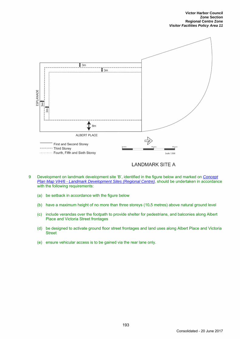
Victor Harbor Council Zone Section
Regional Centre Zone Visitor Facilities Policy Area 11
193
9 Development on landmark development site ‘B’, identified in the figure below and marked on Concept Plan Map ViH/6 - Landmark Development Sites (Regional Centre), should be undertaken in accordance with the following requirements:
(a) be setback in accordance with the figure below
(b) have a maximum height of no more than three storeys (10.5 metres) above natural ground level
(c) include verandas over the footpath to provide shelter for pedestrians, and balconies along Albert Place and Victoria Street frontages
(d) be designed to activate ground floor street frontages and land uses along Albert Place and Victoria Street
(e) ensure vehicular access is to be gained via the rear lane only.
Consolidated - 20 June 2017
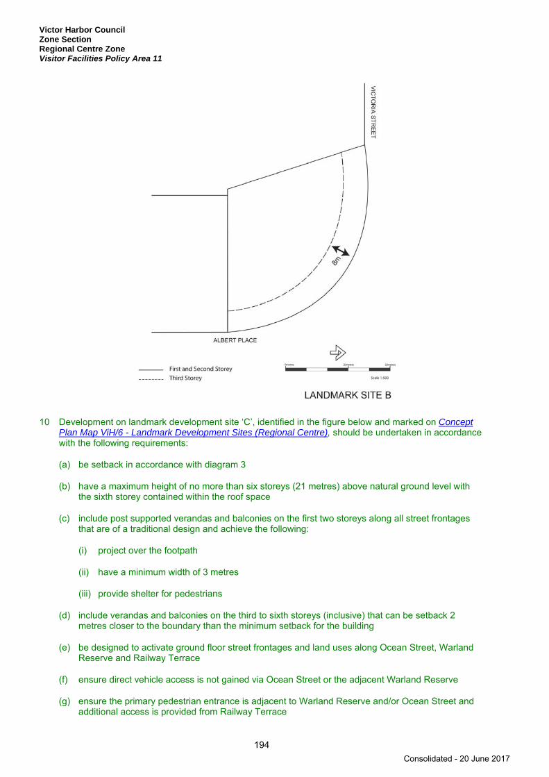
Victor Harbor Council Zone Section Regional Centre Zone Visitor Facilities Policy Area 11
194
10 Development on landmark development site ‘C’, identified in the figure below and marked on Concept Plan Map ViH/6 - Landmark Development Sites (Regional Centre), should be undertaken in accordance with the following requirements:
(a) be setback in accordance with diagram 3
(b) have a maximum height of no more than six storeys (21 metres) above natural ground level with the sixth storey contained within the roof space
(c) include post supported verandas and balconies on the first two storeys along all street frontages that are of a traditional design and achieve the following:
(i) project over the footpath
(ii) have a minimum width of 3 metres
(iii) provide shelter for pedestrians
(d) include verandas and balconies on the third to sixth storeys (inclusive) that can be setback 2 metres closer to the boundary than the minimum setback for the building
(e) be designed to activate ground floor street frontages and land uses along Ocean Street, Warland Reserve and Railway Terrace
(f) ensure direct vehicle access is not gained via Ocean Street or the adjacent Warland Reserve
(g) ensure the primary pedestrian entrance is adjacent to Warland Reserve and/or Ocean Street and additional access is provided from Railway Terrace
Consolidated - 20 June 2017

Victor Harbor Council Zone Section
Regional Centre Zone Visitor Facilities Policy Area 11
195
(h) include articulated and modelled facades to Ocean Street, Railway Terrace and Warland Reserve including the use of large balconies, sun shades and fin walls
(i) utilise building materials and design elements that will reinforce traditional materials and consist of stone, brick, rendered masonry and metal cladding with minimal ornament, overall high solid to void rations, vertical proportioning of fenestration patterns and deep reveals to windows and doors
(j) include pitched hipped or gabled corrugated steel roof
(k) ensure services are concealed within the roof space or behind parapets and are not be visible from public areas.
11 Development on landmark development site ‘D’, identified in the figure below and marked on Concept Plan Map ViH/6 - Landmark Development Sites (Regional Centre), should be undertaken in accordance with the following requirements:
(a) be setback in accordance with the figure below
(b) have a maximum height of no more than five storeys (17.5 metres) above natural ground level
(c) include verandas and balconies of a traditional scale to the Ocean Street and Albert Place frontages
(d) ensure ground floor pedestrian access to the public car park in Stuart Street is provided, and if applicable form part of an internal mall or arcade arrangement through the site to Crozier Street and/or Ocean Street
(e) be designed to activate ground floor street frontages and land uses along Crozier Street and Ocean Street and to any internal mall or arcade
(f) ensure vehicular access is to be gained via Crozier Street.
Consolidated - 20 June 2017

Victor Harbor Council Zone Section Regional Centre Zone Visitor Facilities Policy Area 11
196
12 Development on landmark development site ‘F’, identified in the figure below and marked on Concept Plan Map ViH/6 - Landmark Development Sites (Regional Centre), should be undertaken in accordance with the following requirements:
(a) be setback in accordance with the figure below
(b) have a maximum height of no more than three storeys (10.5 metres) above natural ground level
(c) include verandas over the footpath to provide shelter for pedestrians and balconies on the Victoria Street frontage
(d) be designed to activate ground floor street frontages to Victoria Street.
Consolidated - 20 June 2017
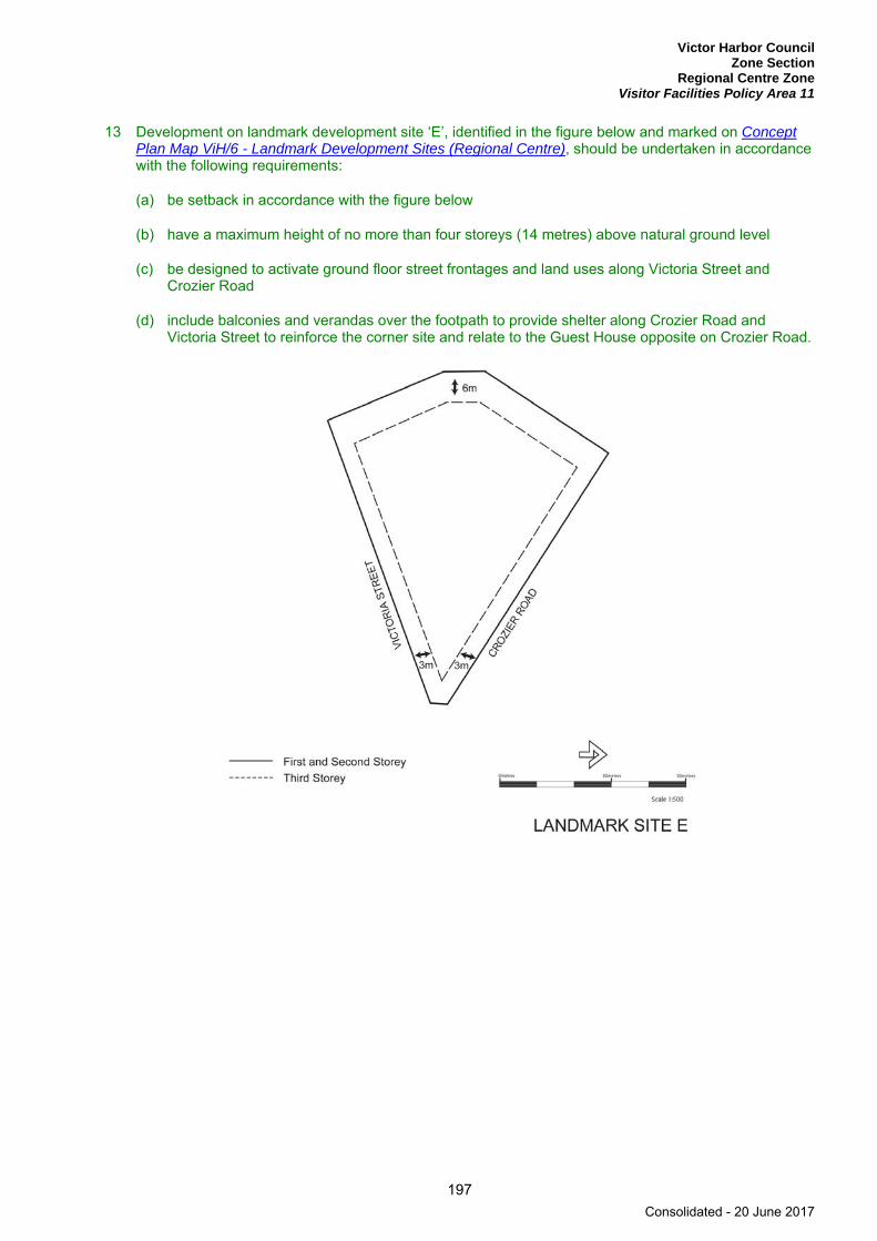
Victor Harbor Council Zone Section
Regional Centre Zone Visitor Facilities Policy Area 11
197
13 Development on landmark development site ‘E’, identified in the figure below and marked on Concept Plan Map ViH/6 - Landmark Development Sites (Regional Centre), should be undertaken in accordance with the following requirements:
(a) be setback in accordance with the figure below
(b) have a maximum height of no more than four storeys (14 metres) above natural ground level
(c) be designed to activate ground floor street frontages and land uses along Victoria Street and Crozier Road
(d) include balconies and verandas over the footpath to provide shelter along Crozier Road and Victoria Street to reinforce the corner site and relate to the Guest House opposite on Crozier Road.
Consolidated - 20 June 2017

Victor Harbor Council Zone Section Regional Centre Zone
198
PROCEDURAL MATTERS
Complying Development Complying developments are prescribed in Schedule 4 of the Development Regulations 2008.
In addition, the following forms of development (except where the development is non-complying) are complying:
A change of use to a shop, office, consulting room or any combination of these uses where all of the following are achieved:
(a) the area to be occupied by the proposed development is located in an existing building and is currently used as a shop, office, consulting room or any combination of these uses
(b) the development is located inside any of the following area(s):
(i) Business Policy Area 15
(ii) Shopping Policy Area 16
(c) the building is not a State heritage place
(d) it will not involve any alterations or additions to the external appearance of a local heritage place as viewed from a public road or public space
(e) if the proposed change of use is for a shop that primarily involves the handling and sale of foodstuffs, it achieves either (i) or (ii):
(i) all of the following:
(A) areas used for the storage and collection of refuse are sited at least 10 metres from any Residential Zone boundary or a dwelling (other than a dwelling directly associated with the proposed shop)
(B) if the shop involves the heating and cooking of foodstuffs in a commercial kitchen and is within 30 metres of any Residential Zone boundary or a dwelling (other than a dwelling directly associated with the proposed shop), an exhaust duct and stack (chimney) exists or is capable of being installed for discharging exhaust emissions
(ii) the development is the same or substantially the same as a development, which has previously been granted development approval under the Development Act 1993 or any subsequent Act and Regulations, and the development is to be undertaken and operated in accordance with the conditions attached to the previously approved development
(f) if the change in use is for a shop with a gross leasable floor area greater than 250 square metres and has direct frontage to an arterial road, it achieves either (i) or (ii):
(i) the primary vehicle access (being the access where the majority of vehicles access / egress the site of the proposed development) is from a road that is not an arterial road
(ii) the development is located on a site that operates as an integrated complex containing two or more tenancies (and which may comprise more than one building) where facilities for off-street vehicle parking, vehicle loading and unloading, and the storage and collection of refuse are shared
(g) off-street vehicular parking is provided in accordance with the rate(s) specified in Table ViH/2 - Off Street Vehicle Parking Requirements and Table ViH/3 - Off Street Bicycle Parking Requirements to the nearest whole number, except in any one of more of the following circumstances:
Consolidated - 20 June 2017

Victor Harbor Council Zone Section
Regional Centre Zone
199
(i) the building is a local heritage place
(ii) the development is the same or substantially the same as a development, which has previously been granted development approval under the Development Act 1993 or any subsequent Act and Regulations, and the number and location of parking spaces is the same or substantially the same as that which was previously approved
(iii) the development is located on a site that operates as an integrated complex containing two or more tenancies (and which may comprise more than one building) where facilities for off-street vehicle parking, vehicle loading and unloading, and the storage and collection of refuse are shared.
Non-complying Development Development (including building work, a change in the use of land, or division of an allotment) for the following is non-complying:
Form of development Exceptions
Dwelling Except where it achieves one of the following: (a) it is in conjunction with a non-residential development (b) it is located within the Burke Street Character Policy
Area 7.
Fuel depot
Horticulture
Industry
Major public service depot
Residential flat building Except where in conjunction with a non-residential development.
Road transport terminal
Stock sales yard
Stock slaughter works
Wrecking yard
Public Notification Categories of public notification are prescribed in Schedule 9 of the Development Regulations 2008.
Further, the following forms of development (except where the development is non-complying) are designated:
Category 1 Category 2
Demolition of elements of a Heritage Place identified in Table ViH/5 - State Heritage Places or in Table ViH/4 - Local Heritage Places.
Consolidated - 20 June 2017
Victor Harbor Council Zone Section Residential Zone
200
Residential Zone
Refer to the Map Reference Tables for a list of the maps that relate to this zone.
OBJECTIVES
1 A residential zone comprising a range of dwelling types, including a minimum of 15 per cent affordable housing.
2 Increased dwelling densities in close proximity to centres, public transport routes and public open spaces.
3 Safe, pleasant, convenient and distinctive living environments for all residents provided by housing together with educational, community and recreational facilities of a nature and scale compatible with the amenity of the residential area.
4 A zone primarily accommodating a range of dwelling types at low to medium densities not exceeding two storeys in height above natural ground level.
5 Development that contributes to the desired character of the zone.
DESIRED CHARACTER
Throughout the city there are variations in the character, appearance and density of residential areas. These variations have resulted from a combination of factors including:
(a) different time periods of settlement and building work
(b) different land form and environmental characteristics
(c) the distinction between the holiday home and permanent resident settlement areas.
In recent years many people have been retiring to the coast and many city dwellers have bought a holiday home by the sea. More and more people are choosing the healthy environment and opportunities for leisure, which the South Coast and Victor Harbor provides.
The topography of the zone ranges from gently undulating to quite steep, in some areas affording outstanding views to the Southern Ocean and Encounter Bay.
The zone should provide for a wide range of residential accommodation. Development throughout the whole of the zone should comprise a range of dwelling types resulting in an overall increase in residential densities, making more efficient use of existing infrastructure and underutilised land. Special needs housing including dependent accommodation and supported accommodation (nursing homes, hostels, and retirement complexes and villages) are envisaged within the zone.
Development of the coast can have a negative impact on landscape values, particularly through the uncontrolled sprawl of the township and the inappropriate siting of buildings and structures upon ridgelines. Within the zone, new development (via infill and re-development of underutilised land) is preferred and will avoid or minimise adverse impacts on coastal resources and their values.
Development that promotes the sustainability of the community by encouraging social diversity and ensuring access to basic services is to be encouraged.
The topography along the coast varies considerably and the attributes of good coastal proximity should be capitalised on in terms of orientation and views, where available.
Consolidated - 20 June 2017
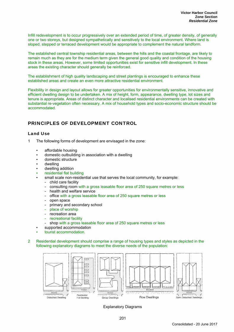
Victor Harbor Council Zone Section
Residential Zone
201
Infill redevelopment is to occur progressively over an extended period of time, of greater density, of generally one or two storeys, but designed sympathetically and sensitively to the local environment. Where land is sloped, stepped or terraced development would be appropriate to complement the natural landform.
The established central township residential areas, between the hills and the coastal frontage, are likely to remain much as they are for the medium term given the general good quality and condition of the housing stock in these areas. However, some limited opportunities exist for sensitive infill development. In these areas the existing character should generally be reinforced.
The establishment of high quality landscaping and street plantings is encouraged to enhance these established areas and create an even more attractive residential environment.
Flexibility in design and layout allows for greater opportunities for environmentally sensitive, innovative and efficient dwelling design to be undertaken. A mix of height, form, appearance, dwelling type, lot sizes and tenure is appropriate. Areas of distinct character and localised residential environments can be created with substantial re-vegetation often necessary. A mix of household types and socio-economic structure should be accommodated.
PRINCIPLES OF DEVELOPMENT CONTROL
Land Use 1 The following forms of development are envisaged in the zone:
▪ affordable housing ▪ domestic outbuilding in association with a dwelling ▪ domestic structure ▪ dwelling ▪ dwelling addition ▪ residential flat building ▪ small scale non-residential use that serves the local community, for example:
- child care facility - consulting room with a gross leasable floor area of 250 square metres or less - health and welfare service - office with a gross leasable floor area of 250 square metres or less - open space - primary and secondary school - place of worship - recreation area - recreational facility - shop with a gross leasable floor area of 250 square metres or less
▪ supported accommodation ▪ tourist accommodation.
2 Residential development should comprise a range of housing types and styles as depicted in the following explanatory diagrams to meet the diverse needs of the population:
Explanatory Diagrams
Consolidated - 20 June 2017

Victor Harbor Council Zone Section Residential Zone
202
3 Development listed as non-complying is generally inappropriate.
4 Vacant or underutilised land should be developed in an efficient and co-ordinated manner to increase housing choice by providing dwellings at densities higher than, but compatible with adjoining residential development.
5 Non-residential development such as shops, schools and consulting rooms should be of a nature and scale that:
(a) serves the local community
(b) is consistent with the character of the locality
(c) does not detrimentally impact on the amenity of nearby residents
6 The use and placement of outbuildings should be ancillary to and in association with a dwelling or dwellings.
Form and Character 7 Development should not be undertaken unless it is consistent with the desired character for the zone.
8 Dwellings should have a maximum building height of no more than 9 metres (two storeys) as measured from existing natural ground level, unless otherwise prescribed within relevant policy areas.
9 Dwellings and outbuildings located in elevated or undulating areas should be designed and sited to be unobtrusive and not detract from the character of the area, and comply with the following:
(a) be comprised of low profile buildings with roof lines that complement the natural form of the land
(b) ensure the mass of buildings complement the contours of the land and is minimised by incorporating variations in the wall and roof lines
(c) incorporate large eaves, verandas and pergolas into designs so as to create shadowed areas which reduce the bulky appearance of buildings.
10 Large individual housing developments comprising more than 30 dwellings should contain a mix of housing types and sizes, and be designed to reduce the impact of the development on the existing locality.
11 Accommodation for the aged and disabled may merit special consideration for development at higher density than prescribed within the relevant policy area. This will be subject to compliance with the relevant Performance Criteria for Residential Accommodation for the Aged and People with Disabilities.
12 Hammer-head allotments should only occur where all of the following applies:
(a) the allotments are located within one of the following policy areas:
(i) Bay Road Policy Area 12
(ii) Hindmarsh River Policy Area 17
(iii) Town Centre Policy Area 22
(iv) Waterfront Policy Area 24
(v) Yilki Residential Policy Area 25
(b) the allotments have direct vehicle access to a public road and the proposed access achieves one of the following:
Consolidated - 20 June 2017

Victor Harbor Council Zone Section
Residential Zone
203
(i) a minimum width of 5 metres for the entire length of the hammer-head handle, where the proposed access is designed to provide access to no more than 2 dwellings
(ii) a minimum width of 6 metres for the entire length of the hammer-head handle, where the proposed access is designed to provide access to more than 2 dwellings
(c) landscaping is provided along the length of the hammer-head handle.
13 Non-residential development should be designed to serve the needs of the local community, be small in scale and has a maximum gross leasable floor area of 250 square metres.
14 Non-residential development should be landscaped in a manner that will enhance the appearance of the development and provide continuity with the residential streetscape.
15 Tourist accommodation should be in the form of small scale bed and breakfast activities and be capable of providing adequate on-site car parking.
Affordable Housing 16 Affordable housing should be distributed throughout the zone to avoid over-concentration of similar
types of housing in a particular area.
Consolidated - 20 June 2017
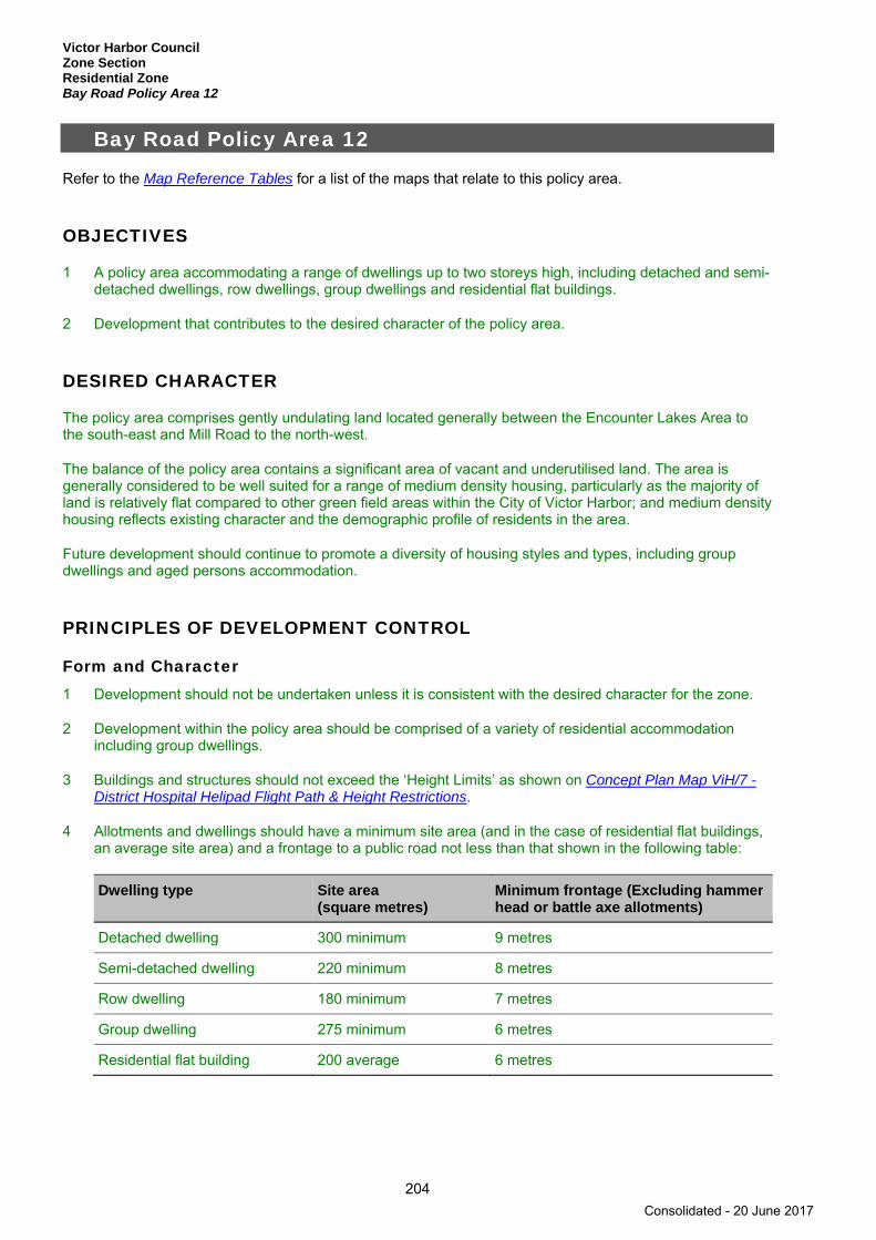
Victor Harbor Council Zone Section Residential Zone Bay Road Policy Area 12
204
Bay Road Policy Area 12
Refer to the Map Reference Tables for a list of the maps that relate to this policy area.
OBJECTIVES
1 A policy area accommodating a range of dwellings up to two storeys high, including detached and semi-detached dwellings, row dwellings, group dwellings and residential flat buildings.
2 Development that contributes to the desired character of the policy area.
DESIRED CHARACTER
The policy area comprises gently undulating land located generally between the Encounter Lakes Area to the south-east and Mill Road to the north-west.
The balance of the policy area contains a significant area of vacant and underutilised land. The area is generally considered to be well suited for a range of medium density housing, particularly as the majority of land is relatively flat compared to other green field areas within the City of Victor Harbor; and medium density housing reflects existing character and the demographic profile of residents in the area.
Future development should continue to promote a diversity of housing styles and types, including group dwellings and aged persons accommodation.
PRINCIPLES OF DEVELOPMENT CONTROL
Form and Character 1 Development should not be undertaken unless it is consistent with the desired character for the zone.
2 Development within the policy area should be comprised of a variety of residential accommodation including group dwellings.
3 Buildings and structures should not exceed the ‘Height Limits’ as shown on Concept Plan Map ViH/7 - District Hospital Helipad Flight Path & Height Restrictions.
4 Allotments and dwellings should have a minimum site area (and in the case of residential flat buildings, an average site area) and a frontage to a public road not less than that shown in the following table:
Dwelling type Site area (square metres)
Minimum frontage (Excluding hammer head or battle axe allotments)
Detached dwelling 300 minimum 9 metres
Semi-detached dwelling 220 minimum 8 metres
Row dwelling 180 minimum 7 metres
Group dwelling 275 minimum 6 metres
Residential flat building 200 average 6 metres
Consolidated - 20 June 2017

Victor Harbor Council Zone Section
Residential Zone Encounter Bay Policy Area 13
205
Encounter Bay Policy Area 13
Refer to the Map Reference Tables for a list of the maps that relate to this policy area.
OBJECTIVES
1 A policy area accommodating residential development in the form of detached dwellings on individual allotments up to two storeys in height above natural ground level.
2 Development that contributes to the desired character of the policy area.
DESIRED CHARACTER
The topography of the policy area varies rising steadily up from Encounter Bay to Waitpinga Road and Three Gullies Road to the north. A large proportion of the policy area is visible from other parts of the township and therefore forms a significant backdrop to Victor Harbor itself.
Allotments to the west of Battye Road are well suited for residential development given their location adjacent to the established built up area of Victor Harbor and the spectacular coastal views.
Existing residential development comprises a predominance of one and two storey detached dwellings, on allotments generally in excess of 700 square metres in area. Most dwellings have been designed and sited in order to obtain views to Encounter Bay and other coastal features such as The Bluff.
Development in the policy area will comprise primarily detached dwellings on large allotments. This is a consequence of the slope of the land, much of which is too steep to readily accommodate compact housing forms and the preference to concentrate medium density housing adjacent to services and facilities provided within the town centre.
Two large sections of broad acre land, which are suitable for residential development, are located at the northern end of the policy area, adjacent to Waitpinga Road. The division of this land for residential purposes should create allotments of a similar area and configuration to that already established in the zone.
Many existing dwellings have resulted in extensive earthworks, in part due to the topography of the site, but also due to the scale and design of the dwellings, which do not complement the natural slope of the land. As a consequence many dwellings dominate the skyline.
Notwithstanding this existing character, minimal earthworks are to be undertaken so development can complement the natural landform.
The mass and vertical profile of buildings will be minimised by incorporating articulations in wall and roof lines and by floor plans which complement the contours of the land.
PRINCIPLES OF DEVELOPMENT CONTROL
Form and Character 1 Development should not be undertaken unless it is consistent with the desired character for the policy
area.
2 Development east of Inman Valley Road and west of Bacchus Road should be undertaken in accordance with Concept Plan Map ViH/8 - Bacchus Road (Encounter Bay) to create an open rural setting entering into the Victor Harbor township.
Consolidated - 20 June 2017

Victor Harbor Council Zone Section Residential Zone Encounter Bay Policy Area 13
206
3 Detached dwellings should have a minimum site area of at least 560 square metres and a minimum frontage of 15 metres.
4 Development within the policy area should be comprised of detached dwellings that are no more than two storeys in height.
5 Development of more than one storey in height should be designed in accordance with the following:
(a) have a height, bulk and scale that is relative to the adjoining dwellings
(b) on sloping sites, ensure that the design of the building is stepped in accordance with the slope of the land
(c) ensure the building is articulated to break down its apparent bulk.
6 Residential development in the form of semi-detached dwellings, row dwellings, group dwellings or residential flat buildings should not be undertaken within the policy area.
7 Development including the creation of roads and allotments should be designed, sited and orientated to:
(a) maximise the views from dwellings into the valleys and Encounter Bay
(b) minimise the need for excavation and landfill by ensuring that the majority of the roads follow the contours of the land and the longer dimension of allotments are perpendicular to the contours of the land
(c) ensure development does not require direct access to or from Inman Valley Road
(d) minimise the bulk and scale of buildings so that they do not dominate the landscape
(e) minimise the need for cut and fill of the natural ground profile and the need for retaining walls.
8 Development south west of Inman Valley Road and North West of Mill Road should not be erected with finished floor levels above the 44.5 metre AHD contour, to retain the open hills face character of the backdrop to Victor Harbor.
9 Retaining walls, batter slopes and excavated faces over 1 metre in height and located between a building and a road frontage, should be stepped in increments of not more than 1 metre and constructed to allow the establishment of landscaping above and to the side.
Land Division 10 Land division located wholly or partly above the 22 metre AHD level as shown on Concept Plan Map
ViH/8 - Bacchus Road (Encounter Bay) should only be divided in accordance with the concept plan to maintain an open rural setting entering into the Victor Harbor township.
Consolidated - 20 June 2017
Victor Harbor Counci Zone Section
Residential Zone Hayborough Policy Area 14
207
Hayborough Policy Area 14
Refer to the Map Reference Tables for a list of the maps that relate to this policy area.
OBJECTIVES
1 A policy area accommodating detached and semi-detached dwellings up to two storeys in height.
2 Development that is designed and sited so that the profiles of buildings complement the slope of the land.
3 Development south of Hindmarsh Road that maintains the attractiveness and amenity of the outstanding views of the bay and islands.
4 Development that is sited to minimise the disturbance to views obtained from public vantage points, such as the Kleinig Hill Lookout.
5 Development that retains and enhances the outstanding views of the bay and Granite Island that are obtained when entering the township from Hindmarsh Road, Adelaide Road or Port Elliot Road.
6 Development that contributes to the desired character of the policy area.
DESIRED CHARACTER
The policy area contains a growing proportion of dwellings which are two storey or split-level in design, in order to take advantage of coastal views. Commanding views are available from the most elevated sections of the area, and consequently those areas are also quite visible from many viewing points on the coastal flats adjacent.
The pleasant environment and recreational opportunities afforded by a coastal setting ensure the popularity of this location for residential development. At the same time, the coastline is an important recreational resource for the general community as well as for residents in beach-side areas.
As such the purpose of this policy area is to allow for a greater number of residents to take advantage of the pleasant residential environment afforded by Encounter Bay, while maintaining the recreation value of the location for the enjoyment of the wider community.
The outstanding views of Encounter Bay and Granite Island entering into the township from Hindmarsh Road, Adelaide Road or Port Elliot Road will be retained and enhanced when designing future development. The emblematic entry into the township represents a classic seaside panorama of local and regional significance. The views provide a stunning scenic entry into the township of Victor Harbor and have significance beyond this policy area. The value and extent of this scenic vista should not be diminished. Any further development that may occur on the southern side of Hindmarsh Road within this policy area must be of low profile and have consideration and empathy in retaining the outlook enjoyed by locals and visitors to the region.
New development should also be carefully designed in order to minimise the impact on the privacy and amenity of existing properties, with the apparent bulk of new buildings minimised if they are in a highly visible and prominent location.
While a variety of housing forms including one and two storey dwellings are considered appropriate in this policy area, future development will avoid the creation of continuous facades and will be built in response to the slope of the land in order to minimise the volume of earthworks impacting on the natural ground profile.
Consolidated - 20 June 2017
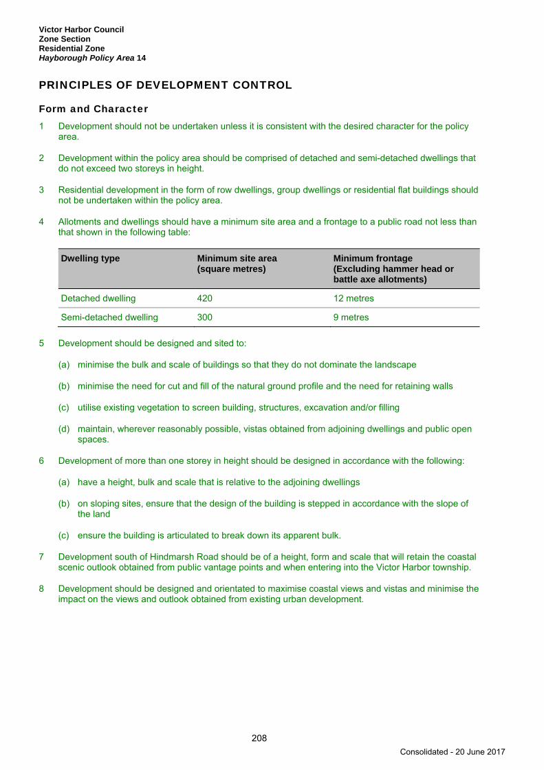
Victor Harbor Council Zone Section Residential Zone Hayborough Policy Area 14
208
PRINCIPLES OF DEVELOPMENT CONTROL
Form and Character 1 Development should not be undertaken unless it is consistent with the desired character for the policy
area.
2 Development within the policy area should be comprised of detached and semi-detached dwellings that do not exceed two storeys in height.
3 Residential development in the form of row dwellings, group dwellings or residential flat buildings should not be undertaken within the policy area.
4 Allotments and dwellings should have a minimum site area and a frontage to a public road not less than that shown in the following table:
Dwelling type Minimum site area (square metres)
Minimum frontage (Excluding hammer head or battle axe allotments)
Detached dwelling 420 12 metres
Semi-detached dwelling 300 9 metres
5 Development should be designed and sited to:
(a) minimise the bulk and scale of buildings so that they do not dominate the landscape
(b) minimise the need for cut and fill of the natural ground profile and the need for retaining walls
(c) utilise existing vegetation to screen building, structures, excavation and/or filling
(d) maintain, wherever reasonably possible, vistas obtained from adjoining dwellings and public open spaces.
6 Development of more than one storey in height should be designed in accordance with the following:
(a) have a height, bulk and scale that is relative to the adjoining dwellings
(b) on sloping sites, ensure that the design of the building is stepped in accordance with the slope of the land
(c) ensure the building is articulated to break down its apparent bulk.
7 Development south of Hindmarsh Road should be of a height, form and scale that will retain the coastal scenic outlook obtained from public vantage points and when entering into the Victor Harbor township.
8 Development should be designed and orientated to maximise coastal views and vistas and minimise the impact on the views and outlook obtained from existing urban development.
Consolidated - 20 June 2017
Victor Harbor Council Zone Section
Residential Zone Hayborough North Policy Area 15
209
Hayborough North Policy Area 15
Refer to the Map Reference Tables for a list of the maps that relate to this policy area.
OBJECTIVES
1 A policy area accommodating residential development in the form of detached and semi-detached dwellings that do not exceed two storeys in height.
2 Residential development that incorporates high quality landscaping and building design in a manner that minimises the impact of the development on the amenity of adjacent residential properties.
3 Development that contributes to the desired character of the policy area.
DESIRED CHARACTER
The policy area comprises gently undulating land which has been gradually developed for residential purposes over the past 30 years. Accordingly, the area contains a mix of holiday home accommodation to more recently developed permanent accommodation. Detached dwellings are the dominant housing type and it is envisaged that lower density forms of housing are to be maintained and comprised of one and two storey dwellings. Row dwellings, group dwellings and residential flat buildings are not encouraged within the policy area.
The vacant broad acre land located at the north-western end of the policy area is generally low lying, with a watercourse dissecting the land. Future land division and residential development of this land should therefore include appropriate engineering investigations to ensure that the design takes into account any flood risk and retain natural watercourses and integrate them into an open space network.
Future residential development of the vacant broad-acre land should create an attractive and highly cohesive low to medium density residential character, consistent with that already established in other parts of the policy area. Flat or gently sloping land is appropriate for compact forms of housing. The configuration of allotments and roads should be designed to allow dwellings to be sited and oriented to take advantage of views to Encounter Bay and/or Brown Hill.
Both Waterport Road and Port Elliot Road are major road linkages between Victor Harbor and Port Elliot/Goolwa. The division and future development of land should also create an attractive streetscape along these frontages. Preferably dwellings should address these frontages, or alternatively an extensive landscape buffer be created as a comprehensive land division scheme so that development does not back onto these principal roads.
PRINCIPLES OF DEVELOPMENT CONTROL
Form and Character 1 Development should not be undertaken unless it is consistent with the desired character for the policy
area.
2 Development within the policy area should be comprised of detached and semi-detached dwellings that do not exceed two storeys in height.
3 Residential development in the form of row dwellings, group dwellings or residential flat buildings should not be undertaken within the policy area.
4 Direct vehicle access onto Waterport Road should not occur within the policy area.
Consolidated - 20 June 2017
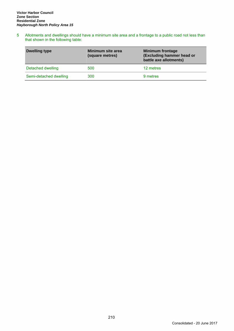
Victor Harbor Council Zone Section Residential Zone Hayborough North Policy Area 15
210
5 Allotments and dwellings should have a minimum site area and a frontage to a public road not less than that shown in the following table:
Dwelling type Minimum site area (square metres)
Minimum frontage (Excluding hammer head or battle axe allotments)
Detached dwelling 500 12 metres
Semi-detached dwelling 300 9 metres
Consolidated - 20 June 2017

Victor Harbor Council Zoen Section
Residential Zone Canterbury West Policy Area 16
211
Canterbury West Policy Area 16
Refer to the Map Reference Tables for a list of the maps that relate to this policy area.
OBJECTIVES
1 A policy area accommodating residential development in the form of detached dwellings of up to two storeys in height.
2 Development that contributes to the desired character of the policy area.
DESIRED CHARACTER
The policy area comprises gently undulating land, located between Armstrong Road (Ring Road) and Canterbury Road.
Future safe and convenient vehicular access should be facilitated via Canterbury Road, Crozier Road or Greenhills Road. North-South and East- West pedestrian and cycling connectivity is also envisaged throughout the re-development of the whole policy area.
The majority of allotments to the west of Armstrong Road (Ring Road) are either vacant, or contain single dwellings. Most of these allotments have frontage to Canterbury Road.
The policy area contains generally low lying land, which is subject to flooding. Future land division and residential development of this land will therefore include appropriate engineering investigations to ensure that the design takes into account any flood risk and appropriate methods of stormwater disposal. Significant natural watercourses are to be integrated into an evolving open space network.
Future residential development of the vacant broad acre land will create an attractive and highly cohesive urban form consisting of detached dwellings at low densities and consistent with the adjacent Mt Breckan Policy Area 21.
PRINCIPLES OF DEVELOPMENT CONTROL
Form and Character 1 Development should not be undertaken unless it is consistent with the desired character for the policy
area.
2 Development within the policy area should be comprised of detached dwellings.
3 Residential development in the form of semi-detached dwellings, row dwellings, group dwellings or residential flat buildings should not be undertaken within the policy area.
4 Detached dwellings should have a minimum site area of at least 420 square metres and a minimum frontage of 12 metres.
5 Roads and allotments should be designed so that dwellings can be located to gain maximum advantage of views into the creek valleys and across reserves and areas of regional open space.
6 Direct vehicle access onto Armstrong Road (Ring Road) should not occur within the policy area.
Consolidated - 20 June 2017

Victor Harbor Council Zone Section Residential Zone Canterbury West Policy Area 16
212
Land Division 7 Land division should result in allotments that are capable of providing a 10 metre wide landscaped
buffer along the Ring Road property boundary, except in places where a sufficient landscaping buffer already exists or where the natural features of the land alleviate the need for a landscape buffer.
Consolidated - 20 June 2017

Victor Harbor Council Zone Section
Residential Zone Hindmarsh River Policy Area 17
213
Hindmarsh River Policy Area 17
Refer to the Map Reference Tables for a list of the maps that relate to this policy area.
OBJECTIVES
1 A policy area accommodating residential development in the form of detached, semi-detached and group dwellings up to two storeys in height.
2 Development that contributes to the desired character of the policy area.
DESIRED CHARACTER
The policy area covers a significant proportion of the Victor Harbor area and is intended to retain the existing character of the area while allowing for limited residential infill and redevelopment. The policy area contains dwellings in a wide range of styles and ages, however its character is established by the predominance of detached dwellings of single storey construction on individual allotments. The majority of dwellings were constructed between the 1960s and 1980’s on relatively large allotments. Setbacks are typically six metres from primary road frontages with lesser setbacks to the secondary frontages of corner allotments. Dwellings are typically of masonry construction with tiled roofs.
Additional minor infill and re-development opportunities exist within the policy area. Such development activity will predominantly involve the creation of hammer-head allotments, the development of the rear of allotments having dual road frontages, the development of lane frontages and the development of group dwellings at the rear of developed allotments. These types of infill development will allow for the retention of character based on the predominant detached dwelling appearance to the street, whilst providing opportunities for an increase in the number and variety of dwellings within the policy area.
PRINCIPLES OF DEVELOPMENT CONTROL
Form and Character 1 Development should not be undertaken unless it is consistent with the desired character for the policy
area.
2 Development within the policy area should be comprised of detached, semi-detached and group dwellings up to two storeys in height.
3 Residential development in the form of row dwellings or residential flat buildings should not be undertaken within the policy area.
4 Allotments and dwellings should have a minimum site area and a frontage to a public road not less than that shown in the following table:
Dwelling type Minimum site area (square metres)
Minimum frontage (excluding hammer head or battle axe allotments)
Detached dwelling 420 12 metres
Semi-detached dwelling 300 9 metres
Group dwelling 300 6 metres
Consolidated - 20 June 2017
Victor Harbor Council Zone Section Residential Zone Hindmarsh Valley Policy Area 18
214
Hindmarsh Valley Policy Area 18
Refer to the Map Reference Tables for a list of the maps that relate to this policy area.
OBJECTIVES
1 A predominantly low and medium density residential area that comprises a range of dwelling types together with a neighbourhood activity centre that is located within a walkable distance of most residents in accordance with Concept Plan ViH/10 - Hindmarsh Valley.
2 Development that contributes to the desired character of the policy area.
DESIRED CHARACTER
Development in the policy area will be undertaken in accordance with the Concept Plan ViH/10 - Hindmarsh Valley and comprise a mix of dwelling types, together with community facilities such as child care centres that attract a broad demographic mix of residents, with emphasis on young people and families. Some small scale non-residential uses that serve the local community will also be developed, including offices associated with dwellings and consulting rooms.
Land division and associated development will occur in an orderly sequence associated with the efficient provision of infrastructure and facilities relating to services such as stormwater management and information technology and telecommunications. There will be a wide range of residential densities and a mix of innovative dwelling types and styles available to cater for diversity in the demographics of the community, with higher dwelling densities in areas close to commercial and community facilities, as well as areas of public open space. A proportion of the total housing stock will also be supported accommodation and affordable housing.
The urban form will have a high degree of:
(a) permeability (physical accessibility, maximising connections with surrounding streets and activities and making their role clear to potential users)
(b) legibility (the extent to which people can understand the layout and find their way, including cues from the road network, open spaces, buildings and land uses)
(c) variety (a mix of complementary land use activities within close proximity to each other).
Buildings will be energy efficient while also responding to and reinforcing the positive aspects of the local environment, such as dramatic views of surrounding hinterland and the vegetation along ridgelines and the Hindmarsh River. Development will also provide for a safe, secure, crime resistant environment where building design and land uses are integrated to facilitate community surveillance. There will also be the provision of well designed accommodation for people with special needs.
Along the Adelaide/Victor Harbor Road a single vehicle access point will be developed approximately 300-550 metres from the intersection of Adelaide/Victor Harbor Road and Welch Road. The vehicle access point will not unreasonably impact upon the arterial road function of the Adelaide/Victor Harbor Road so that efficient vehicle access is provided within the policy area on the eastern side of Hindmarsh River.
At least one vehicle access point will be established to provide a link between the McCracken residential development and this policy area to provide vehicle access and ensure that vehicle access is controlled so that there is not a dramatic increase in through traffic along Coromandel Drive.
A crossing of the Hindmarsh River for vehicles, bicycles and pedestrians will be developed in the area marked ‘River Crossing’ as shown on the Concept Plan Map ViH/10 - Hindmarsh Valley to facilitate the efficient movement throughout the policy area.
Consolidated - 20 June 2017

Victor Harbor Council Zone Section
Residential Zone Hindmarsh Valley Policy Area 18
215
The road network will include a ‘ridgeline road’ close to the western boundary of Precinct 2 Adelaide - Victor Harbor Road as shown on the Concept Plan Map ViH/10 - Hindmarsh Valley. Large indigenous trees are to be established along the side of the road to form a dominant visual element along this ridgeline.
There will be a network of linked parks, reserves and recreation areas that are accessible throughout the policy area and connect with the Hindmarsh River open space corridor. There will also be a wide range of facilities for structured and unstructured recreational opportunities.
The riverine environment along the Hindmarsh River will be protected and enhanced through effective stormwater management, weed removal, revegetation and low impact, unstructured recreation activities. Development should preserve the Hindmarsh River and its riverine environment.
Stormwater management systems will be designed and located to maximise the quality of stormwater, minimise pollutant transfer and erosion into receiving waters and protect downstream receiving waters from flooding. Development will also maximise opportunities for re-use of stormwater and wastewater.
The amenity of the area will be enhanced with appropriate planting and other landscaping works, using locally indigenous plant species as much as possible, with a focus on preserving and complementing scattered individual specimens and groups of mature eucalyptus trees along ridge lines and drainage lines. Verge treatments will be reflective of the older parts of Victor Harbor where there is low front fencing, then a footpath (on at least one side of the road), street trees and the gutter, clearly delineating the difference between the public and private realm, while also providing surveillance and interaction between the two. There will also be substantial buffers between residential development and arterial roads to minimise the noise impact of traffic on residents and provides sufficient space for potential road widening.
Precinct 2 Adelaide - Victor Harbor Road The north-eastern corner of precinct will be the primary gateway to Victor Harbor when entering the town from Adelaide. Views towards the precinct from the Adelaide/Victor Harbor Road will be dominated by public open space and associated stormwater management facilities in the foreground, attractively designed low density residential development in the mid-ground, and trees along the ridgeline in the background and close to the western boundary of this policy area. The interface between residential development and the key areas of public open space and stormwater management areas along the Adelaide/Victor Harbor Road will be carefully designed to ensure an attractive entrance to Victor Harbor. Residential development will also be buffered from noise and air quality impacts associated with the Adelaide/Victor Harbor Road and the Ring Road/Welch Road.
Precinct 3 Strawberry Hill Road This precinct will comprise a range of low-to-medium density residential development. Denser residential development will be located in close proximity to key features of the site such as the Hindmarsh River corridor and other areas of public open space, as well as the major access routes through the precinct. There will be a single, crossing of the Hindmarsh River shared between vehicles, bicycles and pedestrians, located at a narrow point in the river corridor towards the south-west corner of this precinct. There will also be a bicycle/pedestrian link provided to the eastern side of the Adelaide/Victor Harbor Road in the south-east corner of this precinct close to the Strawberry Hill Road Reserve that is linked to a bicycle and pedestrian network which feeds into and along the Hindmarsh River corridor. Residential development will also be buffered from noise and air quality impacts associated with the Ring Road/Welch Road.
Precinct 4 Waggon Road North This precinct will comprise a range of low-to-medium density residential development. Medium density residential development will be located in close proximity to the Neighbourhood Centre, Waggon Road and the Hindmarsh River. Clear and direct bicycle and pedestrian networks will be provided within this precinct between residential areas, activity centre developments and the public recreation facilities along the Hindmarsh River.
Precinct 5 Waggon Road South This precinct will be comprised primarily of low density residential development designed to integrate with key areas of public open space along drainage lines and preserve mature trees throughout the precinct. Development will be protected from the potential impact of flooding.
Consolidated - 20 June 2017

Victor Harbor Council Zone Section Residential Zone Hindmarsh Valley Policy Area 18
216
PRINCIPLES OF DEVELOPMENT CONTROL
Form and Character 1 Development within the “Commercial” area identified on Concept Plan Map ViH/10 - Hindmarsh Valley
should be of a scale and location to provide a range of services to surrounding residents and maximise the number of households within walking distance.
2 The designated neighbourhood activity centre should:
(a) maximise its role as a neighbourhood focus by including a range of community facilities
(b) be physically connected with surrounding residential areas by:
(i) avoiding large expanses of vehicle parking that physically separates the activity centre from surrounding residential areas
(ii) including pedestrian and cycle linkages that enable residents to comfortably walk and cycle directly from residential areas to and also within activity centre facilities
(c) orient development towards and near to public spaces and street frontages
(d) incorporate, where possible, mixed use development along the edges to provide a transition from activity centre uses to residential areas
(e) include shelter for pedestrians along public streets and internal access ways
(f) ensure building façades create diversity of interest and have the appearance of an aggregation of small buildings
(g) ensure roof forms are varied and do not include large expanses of roofline that are visible from the public domain
(h) ensure buildings address the street frontage and open spaces with servicing areas generally accessed via rear lanes or internal to the activity centre and not visible from public streets
(i) retain and enhance existing road reserve vegetation to screen the development and provide additional vegetation to the boundaries of the activity centre fronting residential developments.
3 Development within designated activity centres should be set back a maximum of 3 metres from the primary road frontage(s).
4 Development within the policy area should be undertaken in accordance with Concept Plan Map ViH/10 - Hindmarsh Valley.
5 Dwellings within the areas marked ‘Medium Density Residential Areas’ on Concept Plan Map ViH/10 - Hindmarsh Valley should be designed and sited to front onto the Hindmarsh River corridor and be separated and buffered by a public road.
6 Development in the areas marked ‘Recreation/Conservation/Open Space Areas’ on Concept Plan Map ViH/10 - Hindmarsh Valley should be limited to infrastructure associated with recreation and stormwater management, and the understorey should be restored/revegetated to enhance the conservation value of these areas.
7 Development should include a minimum 15 per cent of residential dwellings for affordable housing. Affordable housing should be located in close proximity to public open space, major transport routes and centres.
8 Affordable housing should be distributed throughout the policy area to avoid over concentration of similar types of housing in a particular area.
Consolidated - 20 June 2017
Victor Harbor Council Zone Section
Residential Zone Hindmarsh Valley Policy Area 18
217
9 Places of worship within the policy area should be restricted to no more than 30 worshippers in any one session to minimise the impact on the amenity of the surrounding area.
10 Development should not occur within 50 metres of the centreline of the Hindmarsh River.
11 A buffer should be provided between residential allotments and arterial roads, to preserve sufficient land for any future duplication of such roads, as well as ensuring visual and acoustic separation for nearby residential development.
12 A ‘Landscape Buffer’ should be provided along the Ring Road/Welch Road and the Adelaide/Victor Harbor Road as shown on Concept Plan Map ViH/10 - Hindmarsh Valley for the purposes of any future road widening, as well as visual, acoustic and air quality buffering for nearby residential development.
13 Direct vehicular access should not be provided to the Ring Road/Welch Road from within this policy area so as to preserve and enhance the heavy vehicle/town-by-pass function of this road.
14 Laneways and service roads should be used to provide access to parking where allotment widths are narrow or the access is required for medium density housing that fronts onto public open space or a busy road.
15 A safe and convenient bicycle and pedestrian link should be developed between the Hindmarsh River and the south-eastern corner of the policy area as well as the provision of a connection to land on the eastern side of the Adelaide/Victor Harbor Road adjacent to this corner of the policy area.
16 The road network should be designed to facilitate traffic movements within the policy area and discourage through traffic.
17 Development including, substantial excavations and the use of impervious surfaces should not occur beneath the canopy of trees which meet the following criteria:
(a) a trunk diameter of more than 200 millimetres, measured one metre above natural ground level
(b) a height of more than 5 metres
(c) are of Australian native origin.
Land Division 18 The layout of land divisions should be based on a grid street pattern and be designed to achieve the
following:
(a) facilitate the efficient movement of traffic and to minimise the length of trips
(b) improve the legibility and permeability of the area including minimising the number of dead-end street/cul-de-sacs
(c) reflect a desirable ‘country town’ character
(d) respond to the topographic variation of the land in order to maximise views from within the public realm
(e) maximise the solar orientation for residential allotments.
Consolidated - 20 June 2017
Victor Harbor Council Zone Section Residential Zone Hindmarsh Valley Policy Area 18
218
PRECINCT SPECIFIC PROVISIONS
Refer to the Map Reference Tables for a list of the maps that relate to the following precincts.
Precinct 2 Adelaide - Victor Harbor Road 19 Development should not be undertaken unless it is consistent with the desired character for the
following precinct.
20 Detached dwellings within the precinct should have a minimum site area of 620 square metres and a minimum frontage of 12 metres.
21 Development within the precinct should be comprised of detached dwellings that do not exceed two storeys in height.
22 A substantial area of public open space should be provided along the Adelaide/Victor Harbor Road in the area marked ‘Recreation/Conservation/Open Space Areas’ on Concept Plan Map ViH/10 - Hindmarsh Valley to provide for the following:
(a) stormwater infrastructure and design features that assist in the management of stormwater from within the precinct
(b) an attractive open space buffer between the residential development in this Precinct and the Adelaide/Victor Harbor Road, particularly close to the intersection of the Adelaide/Victor Harbor Road and Welch Road
(c) public open space and recreation needs of nearby residents.
23 Dwellings in the precinct should be oriented to front public open space, or roads adjoining public open space, to ensure the attractive presentation of development when viewed from the Adelaide/Victor Harbor Road and Welch Road, while also encouraging passive and active surveillance of the public open space.
24 The ‘ridgeline road’ as shown on Concept Plan Map ViH/10 - Hindmarsh Valley, should be designed to emphasise this ridgeline as an important visual element in the landscape by achieving the following:
(a) a wide public road reserve along the ridgeline on the western side of the precinct
(b) preventing residential development along the top of the ridgeline
(c) establishing large, native trees within the road reserve.
25 Large indigenous trees should be planted along the ridgeline on the western edge of precinct to provide a dominant visual element when viewed from a distance.
Precinct 3 Strawberry Hill Road 26 Development should not be undertaken unless it is consistent with the desired character for the
following precinct.
27 Group dwellings, row dwellings and residential flat buildings should be located adjacent one of the following:
(a) substantial areas of public open space including the public open space along the Hindmarsh River
(b) the main access road through the precinct, which runs between Adelaide/Victor Harbor Road and the Hindmarsh River.
Consolidated - 20 June 2017
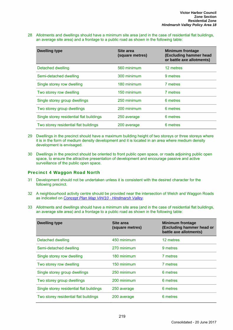
Victor Harbor Council Zone Section
Residential Zone Hindmarsh Valley Policy Area 18
219
28 Allotments and dwellings should have a minimum site area (and in the case of residential flat buildings, an average site area) and a frontage to a public road as shown in the following table:
Dwelling type Site area (square metres)
Minimum frontage (Excluding hammer head or battle axe allotments)
Detached dwelling 560 minimum 12 metres
Semi-detached dwelling 300 minimum 9 metres
Single storey row dwelling 180 minimum 7 metres
Two storey row dwelling 150 minimum 7 metres
Single storey group dwellings 250 minimum 6 metres
Two storey group dwellings 200 minimum 6 metres
Single storey residential flat buildings 250 average 6 metres
Two storey residential flat buildings 200 average 6 metres
29 Dwellings in the precinct should have a maximum building height of two storeys or three storeys where it is in the form of medium density development and it is located in an area where medium density development is envisaged.
30 Dwellings in the precinct should be oriented to front public open space, or roads adjoining public open space, to ensure the attractive presentation of development and encourage passive and active surveillance of the public open space.
Precinct 4 Waggon Road North 31 Development should not be undertaken unless it is consistent with the desired character for the
following precinct.
32 A neighbourhood activity centre should be provided near the intersection of Welch and Waggon Roads as indicated on Concept Plan Map ViH/10 - Hindmarsh Valley.
33 Allotments and dwellings should have a minimum site area (and in the case of residential flat buildings, an average site area) and a frontage to a public road as shown in the following table:
Dwelling type Site area (square metres)
Minimum frontage (Excluding hammer head or battle axe allotments)
Detached dwelling 450 minimum 12 metres
Semi-detached dwelling 270 minimum 9 metres
Single storey row dwelling 180 minimum 7 metres
Two storey row dwelling 150 minimum 7 metres
Single storey group dwellings 250 minimum 6 metres
Two storey group dwellings 200 minimum 6 metres
Single storey residential flat buildings 250 average 6 metres
Two storey residential flat buildings 200 average 6 metres
Consolidated - 20 June 2017
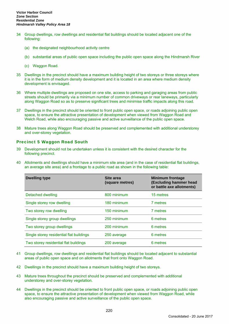
Victor Harbor Council Zone Section Residential Zone Hindmarsh Valley Policy Area 18
220
34 Group dwellings, row dwellings and residential flat buildings should be located adjacent one of the following:
(a) the designated neighbourhood activity centre
(b) substantial areas of public open space including the public open space along the Hindmarsh River
(c) Waggon Road.
35 Dwellings in the precinct should have a maximum building height of two storeys or three storeys where it is in the form of medium density development and it is located in an area where medium density development is envisaged.
36 Where multiple dwellings are proposed on one site, access to parking and garaging areas from public streets should be primarily via a minimum number of common driveways or rear laneways, particularly along Waggon Road so as to preserve significant trees and minimise traffic impacts along this road.
37 Dwellings in the precinct should be oriented to front public open space, or roads adjoining public open space, to ensure the attractive presentation of development when viewed from Waggon Road and Welch Road, while also encouraging passive and active surveillance of the public open space.
38 Mature trees along Waggon Road should be preserved and complemented with additional understorey and over-storey vegetation.
Precinct 5 Waggon Road South 39 Development should not be undertaken unless it is consistent with the desired character for the
following precinct.
40 Allotments and dwellings should have a minimum site area (and in the case of residential flat buildings, an average site area) and a frontage to a public road as shown in the following table:
Dwelling type Site area (square metres)
Minimum frontage (Excluding hammer head or battle axe allotments)
Detached dwelling 800 minimum 15 metres
Single storey row dwelling 180 minimum 7 metres
Two storey row dwelling 150 minimum 7 metres
Single storey group dwellings 250 minimum 6 metres
Two storey group dwellings 200 minimum 6 metres
Single storey residential flat buildings 250 average 6 metres
Two storey residential flat buildings 200 average 6 metres
41 Group dwellings, row dwellings and residential flat buildings should be located adjacent to substantial areas of public open space and on allotments that front onto Waggon Road.
42 Dwellings in the precinct should have a maximum building height of two storeys.
43 Mature trees throughout the precinct should be preserved and complemented with additional understorey and over-storey vegetation.
44 Dwellings in the precinct should be oriented to front public open space, or roads adjoining public open space, to ensure the attractive presentation of development when viewed from Waggon Road, while also encouraging passive and active surveillance of the public open space.
Consolidated - 20 June 2017

Victor Harbor Council Zone Section
Residential Zone Hindmarsh Valley Policy Area 18
221
45 Where multiple dwellings are proposed on one site, access to parking and garaging areas from public streets should be primarily via a minimum number of common driveways or rear laneways, particularly along Waggon Road and the road leading to the crossing over the Hindmarsh River, so as to preserve significant trees and minimise traffic impacts along this road.
Consolidated - 20 June 2017
Victor Harbor Council Zone Section Residential Zone Lakeside Policy Area 19
222
Lakeside Policy Area 19
Refer to the Map Reference Tables for a list of the maps that relate to this policy area.
OBJECTIVES
1 A pleasant lakeside residential area characterised by high quality waterfront housing and landscaped public reserves.
2 Residential development comprising primarily of detached dwellings and a range of other dwelling types developed at low to medium densities that do not exceed two storeys in height.
3 The use and maintenance of the lake in a manner that is compatible with the residential amenity of the locality.
4 Development that contributes to the desired character of the policy area.
DESIRED CHARACTER
From West to East within the policy area there are three distinct residential estates (1990’s – 2010 era), being Encounter Waters, Encounter Lakes and Franklin Island. All three areas are predominantly characterised by a mix of single and two storey dwellings. Encounter Waters is developed within a network of quality open space stormwater wetland areas. Encounter Lakes predominantly has many dwellings with a frontage to an inland tidal lake system, inclusive of man-made beaches and public amenity areas to facilitate water activities. Similarly, Franklin Island also provides an inland tidal system offering allotments with water frontage and public access to man-made beaches, amenities and water activity.
Residential development will be at low to medium densities, up to two storeys in height and comprise primarily of detached dwellings with other housing types in suitable areas.
Development should maintain and further contribute to the establishment of a pleasant residential development consistent with the form and appearance of dwellings already established within the policy area.
PRINCIPLES OF DEVELOPMENT CONTROL
Form and Character 1 Development should not be undertaken unless it is consistent with the desired character for the policy
area.
2 Development within the policy area should comprise primarily detached dwellings and other dwelling types developed at low to medium densities, where visual intrusion into established residential areas is minimised and in close proximity to existing centres, public transport and open space.
3 Buildings and structures should not exceed the ‘Height Limits’ as shown on Concept Plan Map ViH/7 - District Hospital Helipad Flight Path & Height Restrictions.
4 Structures, other than jetties and landings or structures for public recreation should not be constructed in the lake.
Consolidated - 20 June 2017

Victor Harbor Council Zone Section
Residential Zone Lakeside Policy Area 19
223
5 A dwelling should have a minimum site area (and in the case of residential flat buildings, an average site area) and a frontage to a public road as shown in the following table:
Dwelling type Site area (square metres)
Minimum frontage (Excluding hammer head or battle axe allotments)
Detached dwelling 390 minimum 12 metres
Semi-detached dwelling 270 minimum 9 metres
Row dwelling 200 minimum 7 metres
Group dwelling 275 minimum 6 metres
Residential flat building 250 average 6 metres
6 Dwellings should be designed within the following parameters:
Parameter Value
Minimum setback from the lake property boundary 8 metres
Minimum setback to cater for on-site visitor parking 5.5 metres
7 Buildings should be designed and sited to provide varied spaces between buildings on adjoining allotments and varied setbacks from the road and lakeside boundaries so as to avoid the creation of congested and monotonous built form.
8 The external walls and roofs of buildings should not incorporate highly reflective or dilapidated materials which will diminish the appearance of the locality or result in glare to neighbouring properties or drivers.
9 Outbuildings and structures should be sited and designed to complement the dwelling and not detract visually from the amenity of the locality.
10 All stormwater run-off, from both buildings and land located further than 8 metres from the boundary of the lake, should be collected and discharged from the property via underground pipes to the street watertable.
11 Structures should not damage or impair the stability of the rock revetment around the lake.
12 Pontoons, jetties, landings and other similar structures constructed in the lake should comply with all of the following:
(a) be limited to a maximum of one structure per development site
(b) be designed and sited to achieve the following:
(i) maintain the safe use and enjoyment of the lake for recreational purposes
(ii) project no more than 5 metres into the lake as measured horizontally from the lake boundary, and should have a maximum size of 2.5 metres by 4.5 metres with the longer side being orientated parallel to the lake boundary
(iii) be small in scale and constructed of durable low maintenance materials that are suitable to a water environment.
Consolidated - 20 June 2017

Victor Harbor Council Zone Section Residential Zone McCracken Golf Course Policy Area 20
224
McCracken Golf Course Policy Area 20
Refer to the Map Reference Tables for a list of the maps that relate to this policy area.
OBJECTIVES
1 A policy area accommodating a golf course with club house facilities and a motel as well as residential development located on the periphery of the golf course.
2 Provision of a public reserve adjacent to the Hindmarsh River to serve the residents in the policy area.
3 Development that contributes to the desired character of the policy area.
DESIRED CHARACTER
The policy area contains the McCracken Golf Course and low to medium density residential development around the periphery. Residential development will be comprised primarily of detached dwellings however, semi-detached dwellings and group dwellings may be established at the north eastern end of the policy area, immediately adjacent to Adelaide Road.
PRINCIPLES OF DEVELOPMENT CONTROL
Land Use 1 The following forms of development are envisaged in the policy area in addition to the zone:
▪ facilities in association with the golf course ▪ motel.
Form and Character 2 Development should not be undertaken unless it is consistent with the desired character for the policy
area.
3 The policy area should be comprised primarily of residential development, and facilities that are associated with the golf course.
4 Residential development within the policy area should be comprised of detached dwellings with semi-detached dwellings and group dwellings located in the north eastern end of the policy area, immediately adjacent to Adelaide Road.
5 Allotments and dwellings should have a minimum site area and a frontage to a public road as shown in the following table:
Dwelling type Minimum site area (square metres)
Minimum frontage (excluding hammer head or battle axe allotments)
Detached dwelling 420 12 metres
Semi-detached dwelling 300 9 metres
Group dwelling 300 6 metres
6 Direct vehicle access onto Adelaide Road should not occur within the policy area.
Consolidated - 20 June 2017
Victor Harbor Council Zone Section
Residential Zone McCracken Golf Course Policy Area 20
225
7 Buildings located on allotments that front onto the golf course should comply with the following:
(a) be constructed of non-reflective materials and finished in colours which complement the natural colours of the golf course
(b) be sited to allow for landscaping to be established to reduce the visual impact of the buildings.
Consolidated - 20 June 2017
Victor Harbor Council Zone Section Residential Zone Mt Breckan Policy Area 21
226
Mount Breckan Policy Area 21
Refer to the Map Reference Tables for a list of the maps that relate to this policy area.
OBJECTIVES
1 A policy area accommodating residential development in the form of detached dwellings of up to two storeys high.
2 Development that contributes to the desired character of the policy area.
DESIRED CHARACTER
The topography of the policy area is gently undulating and increasing in height to the foothills to the north.
The area is contemporary in character with some very large homes built on generous allotments usually in excess of 600 square metres and considerably larger in the steeper portions of the policy area. Many houses are two-storey or split-level in design. Commanding views are available from the most elevated sections taking advantage of expansive views of the harbour. Due to the generally good condition of housing in the area and the steep topography (in parts), medium density residential development will be limited.
Small scale infill and redevelopment opportunities exist within the zone. This infill should be limited to areas already serviced by sewer and water supplies, with new allotments established for dwellings at a density of one dwelling per 420 square metres to maintain the low density character of the area.
New dwelling sites are to have regard for the privacy and amenity of existing properties, and the appearance of the development if it is in a highly visible and prominent location. New development will also preserve and reinforce the environmental qualities of the area by avoiding interference with remnant vegetation, and minimising alteration to the natural ground levels to protect soil stability and water quality.
The site area, design, siting and appearance of development will complement the natural contours of the land to minimise environmental and visual impacts.
PRINCIPLES OF DEVELOPMENT CONTROL
Form and Character 1 Development should not be undertaken unless it is consistent with the desired character for the policy
area.
2 Development within the policy area should be comprised of detached dwellings on individual allotments up to two storeys in height.
3 Residential development in the form of semi-detached dwellings, row dwellings, group dwellings or residential flat buildings should not be undertaken within the policy area.
4 Development of more than one storey in height should be designed in accordance with the following:
(a) have a height, bulk and scale that is relative to the adjoining dwellings
(b) on sloping sites, ensure that the design of the building is stepped in accordance with the slope of the land
(c) ensure the building is articulated to break down its apparent bulk.
Consolidated - 20 June 2017

Victor Harbor Council Zone Setion
Residential Zone Mount Breckan Policy Area 21
227
5 Development should relate to the slope of the land and be designed and sited to achieve the following:
(a) minimise the bulk and scale of buildings so that they do not dominate the landscape
(b) minimise the need for cut and fill of the natural ground profile and the need for retaining walls
(c) utilise existing vegetation to screen building, structures, excavation and/or filling
(d) maintain vistas obtained from adjoining dwellings and public open spaces.
Land Division 6 Land division should result in allotments that have a minimum site area of 420 square metres and a
minimum frontage of 12 metres.
Consolidated - 20 June 2017
Victor Harbor Council Zone Section Residential Zone Town Centre Policy Area 22
228
Town Centre Policy Area 22
Refer to the Map Reference Tables for a list of the maps that relate to this policy area.
OBJECTIVES
1 A policy area accommodating a range of dwelling types up to two storeys high.
2 Increased dwelling densities and smaller dwelling types, including supported accommodation that takes advantage of the close proximity to township services within the adjacent Regional Centre Zone.
3 Development that contributes to the desired character of the policy area.
DESIRED CHARACTER
The policy area covers a specific area within the zone identified as suitable for small and large-scale redevelopment at different densities—suitable to accommodate a range of dwelling types for the following reasons:
(a) its proximity to shopping and community facilities
(b) the potential availability of large sites to accommodate integrated higher density housing development
(c) the existing mixed composition of dwelling types
(d) the relatively flat topography.
It is proposed that all forms of housing are appropriate within the policy area, including supported accommodation, which will benefit from the proximity to town services and facilities.
PRINCIPLES OF DEVELOPMENT CONTROL
Form and Character 1 Development should not be undertaken unless it is consistent with the desired character for the policy
area.
2 Development within the policy area should be comprised of a range of housing types, including supported accommodation, to meet the diverse needs of the community.
3 Medium density development should occur on amalgamated sites to facilitate appropriate site planning and building layout including safe vehicular access, egress and parking.
Consolidated - 20 June 2017

Victor Harbor Council Zone Section
Residential Zone Town Centre Policy Area 22
229
4 Allotments and dwellings should have a minimum site area (and in the case of residential flat buildings, an average site area) and a frontage to a public road as shown in the following table:
Dwelling type Site area (square metres)
Minimum frontage (excluding hammer head or battle axe allotments)
Detached dwelling 300 minimum 9 metres
Semi-detached dwelling 220 minimum 8 metres
Row dwelling 180 minimum 7 metres
Group dwelling 275 minimum 6 metres
Residential flat building 200 average 6 metres
5 Development along Kullaroo Road and Almond Avenue should be sited and designed in a manner compatible with the flood prone nature of the land.
Consolidated - 20 June 2017
Victor Harbor Council Zone Section Residential Zone Waitpinga Policy Area 23
230
Waitpinga Policy Area 23
Refer to the Map Reference Tables for a list of the maps that relate to this policy area.
OBJECTIVES
1 A policy area accommodating residential development in the form of detached dwellings up to two storeys high, designed in a manner that complements and enhances the character and amenity of the hills living environment.
2 Development that contributes to the desired character of the policy area.
DESIRED CHARACTER
The policy area comprises two specific sections of broad acre land within the Residential Zone, which whilst suitable for residential purposes, have a relatively steep topography.
Allotments within the policy area should have a minimum site area of 1500 square metres to enable the siting of a dwelling and associated structures in a manner which minimises the visual impact and dominance of buildings, structures and earthworks, particularly when viewed from neighbouring properties and roads within the policy area.
Considerable attention will be given to the impact of any subsequent development on the privacy and amenity of existing properties, and the appearance of the development if it is in a highly visible and prominent location. Development will also preserve and reinforce the environmental qualities of the area by avoiding interference with natural drainage lines and creeks, remnant vegetation, and minimising alteration to the natural ground levels.
PRINCIPLES OF DEVELOPMENT CONTROL
Form and Character 1 Development should not be undertaken unless it is consistent with the desired character for the policy
area.
2 Development within the policy area should be comprised of detached dwellings up to two storeys in height.
3 Residential development in the form of semi-detached dwellings, row dwellings, group dwellings or residential flat buildings should not be undertaken within the policy area.
4 Development including the creation of roads and allotments should be designed, sited and orientated to:
(a) minimise the need for excavation and landfill by ensuring that the majority of the roads length follows the contours of the land and the longer dimension of allotments are perpendicular to the contours of the land
(b) minimise the bulk and scale of buildings so that they do not dominate the landscape
(c) minimise the need for cut and fill of the natural ground profile and the need for retaining walls.
5 Direct access onto Waitpinga Road should not occur within the policy area.
Consolidated - 20 June 2017
Victor Harbor Council Zone Section
Residential Zone Waitpinga Policy Area 23
231
6 Retaining walls, batter slopes and excavated faces over 1 metre in height and located between a building and a road frontage, should be stepped down in increments of not more than 1 metre and constructed to allow the establishment of landscaping above and to the side.
Land Division 7 Land division should result in allotments that have a minimum site area of 1500 square metres and a
minimum frontage of 20 metres.
8 Land division should provide an integrated design layout for the whole policy area and create a 10 metre wide landscape buffer aligning Waitpinga Road.
Consolidated - 20 June 2017

Victor Harbor Council Zone Section Residential Zone Waterfront Policy Area 24
232
Waterfront Policy Area 24
Refer to the Map Reference Tables for a list of the maps that relate to this policy area.
OBJECTIVES
1 A policy area comprising a wide range of residential housing types and tourist accommodation of up to three storeys high.
2 Cohesive development that reflects a seaside village character with attractive buildings carefully related to each other to take advantage of views across Encounter Bay.
3 Preservation of the amenity and recreation value of the coastline.
4 Development that contributes to the desired character of the policy area.
DESIRED CHARACTER
The policy area contains that portion of the zone adjacent to the coast. It includes areas abutting or immediately adjacent to Franklin Parade, the Esplanade and Bridge Terrace.
The pleasant environment and recreational opportunities afforded by a coastal setting ensure the popularity of this location for residential development. At the same time, the coastline is an important recreational resource for the general community as well as for residents in beach-side areas.
As such the purpose of this policy area is to allow for a greater number of residents to take advantage of the pleasant residential environment afforded by Encounter Bay, while maintaining the recreation value of the location for the enjoyment of the wider community. To achieve this scenario a greater number of dwellings than exists is anticipated and dwellings are expected to be in the form of residential flat buildings or apartments, row dwellings and other forms of multiple dwellings.
Many existing properties located adjacent to the foreshore enjoy wide sweeping views of coastal features, including Encounter Bay. Inevitably, as the popularity of the coastal residential environment increases, so to will the pressure to redevelop existing residential properties.
In many circumstances development which complies with the relevant height and setback requirements of the Development Plan will result in the loss of some views, particularly those gained over adjoining land. Whilst it is desirable that any loss of views is minimised, there can be no expectation that all existing views will be retained as future development is undertaken in the policy area.
In the coastal foreshore area, development can contribute positively to the character of an area if it results in a relatively consistent but interesting built form, without detracting from the natural coastal environment.
The policy area will continue to develop as an attractive residential area providing a range of dwelling types for both permanent and short-term accommodation. The present disparate character of the townscape should be transformed by a more substantial and cohesive built form. Dwellings will be designed to maintain direct frontage and address Franklin Parade, The Esplanade and Bridge Terrace, where frontage exists to these public roads.
Residential development will establish a character typified by high quality building design and landscaping that will minimise the adverse impacts on the amenity of adjacent residential properties.
Whilst a variety of housing forms including one, two and three storey dwellings are considered appropriate, future development will avoid the creation of continuous facades fronting Franklin Parade, The Esplanade and Bridge Terrace by ensuring articulation and interest in their design.
Consolidated - 20 June 2017

Victor Harbor Council Zone Section
Residential Zone Waterfront Policy Area 24
233
Development will contribute to the creation of attractive streetscapes through the design and architecture of dwellings, which will incorporate themes, materials, and colours that will reinforce the urban coastal character of the policy area.
PRINCIPLES OF DEVELOPMENT CONTROL
Land Use 1 The following forms of development are envisaged in the policy area:
▪ domestic outbuilding in association with a dwelling ▪ dwelling ▪ dwelling addition ▪ residential flat buildings ▪ serviced apartments ▪ tourist accommodation.
Form and Character 2 Development should not be undertaken unless it is consistent with the desired character for the policy
area.
3 Development should not result in a continuous built form along Franklin Parade, Kent Drive, The Esplanade or Bridge Terrace. Elevations that front onto a public road and are greater than one storey in height should not extend for a distance greater than 90 per cent of the allotment frontage and not result in a continuous façade of more than 15 metres in length.
4 Dwellings should be designed within the following parameters:
Parameter Value
Maximum building height (from natural ground level) Three storeys (10.5 metres)
Minimum setback from side boundaries 1 metre or 2 metres where height of the wall exceeds 6 metres
5 Allotments and dwellings should have a minimum site area (and in the case of residential flat buildings, an average site area per dwelling) and a frontage to a public road as shown in the following table:
Dwelling Type Site area (square metres)
Minimum Frontage (Excluding hammer head or battle axe allotments)
Detached dwelling 300 minimum 9 metres
Semi-detached dwelling 220 minimum 8 metres
Row dwelling 180 minimum 7 metres
Group dwelling 275 minimum 6 metres
Residential flat building 200 average 6 metres
6 Development that exceeds one storey in height should be designed and sited to ensure that:
(a) the height and bulk of the proposed building is relative to adjoining dwellings
(b) the building is stepped in accordance with the slope of the land
Consolidated - 20 June 2017
Victor Harbor Council Zone Section Residential Zone Waterfront Policy Area 24
234
(c) the form of the building is articulated to reduce its apparent bulk.
7 Tourist accommodation facilities, such as bed and breakfast facilities or serviced apartments, should be developed at a scale that is in context with the adjoining residential development and will enhance the quality and range of accommodation available to local tourists. Intensive developments such as hotels, motels, taverns or restaurants should not occur within the policy area.
8 Car parking for tourist accommodation should be provided in shared and integrated areas and sited in unobtrusive locations.
9 Car parking should be provided below or behind buildings and not intrude on to the frontages of Bridge Terrace and The Esplanade.
10 Garages and/or carports that front onto a public road should be integrated into ‘and not dominate’ the design of the associated building.
Consolidated - 20 June 2017
Victor Harbor Council Zone Section
Residential Zone Yilki Residential Policy Area 25
235
Yilki Residential Policy Area 25
Refer to the Map Reference Tables for a list of the maps that relate to this policy area.
OBJECTIVES
1 A policy area accommodating a range of dwelling types up to two storeys in height that provide further diversity to the existing housing stock in terms of style, form and density.
2 The regeneration of housing that is under-utilised to provide higher housing density to respond to growth scenarios.
3 The visual appearance of residential streets progressively improved through well designed new dwellings, substantial front garden landscaping and street tree planting.
4 Development that contributes to the desired character of the policy area.
DESIRED CHARACTER
The policy area covers a specific area within the zone which contains a high concentration of original holiday homes which have been identified as suitable for small and large-scale re-development at a range of densities. This area has been selected as suitable to accommodate higher density forms of housing developments, including group dwellings and residential flat buildings for the following reasons:
(a) the condition of existing housing stock is such that it is desirable and potentially economical for redevelopment to occur
(b) the potential availability of amalgamated sites to accommodate integrated multi-dwelling developments
(c) the immediate proximity of this area relative to the Encounter Bay foreshore, and the open space/recreational opportunities this area provides.
Amalgamation of allotments will be encouraged to enable appropriately designed low to medium density re-development. Through a process of retaining existing housing stock in good condition, and the re-development of other properties, the character of the area will be dynamic and should reflect a diversity of housing types and densities. Development will be of a high standard of design to ensure that any new development is well integrated with the surrounding urban landscape.
PRINCIPLES OF DEVELOPMENT CONTROL
Form and Character 1 Development should not be undertaken unless it is consistent with the desired character for the policy
area.
2 Development within the policy area should be comprised of a range of residential housing types up to two storeys in height.
Consolidated - 20 June 2017
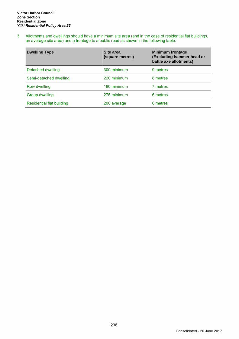
Victor Harbor Council Zone Section Residential Zone Yilki Residential Policy Area 25
236
3 Allotments and dwellings should have a minimum site area (and in the case of residential flat buildings, an average site area) and a frontage to a public road as shown in the following table:
Dwelling Type Site area (square metres)
Minimum frontage (Excluding hammer head or battle axe allotments)
Detached dwelling 300 minimum 9 metres
Semi-detached dwelling 220 minimum 8 metres
Row dwelling 180 minimum 7 metres
Group dwelling 275 minimum 6 metres
Residential flat building 200 average 6 metres
Consolidated - 20 June 2017
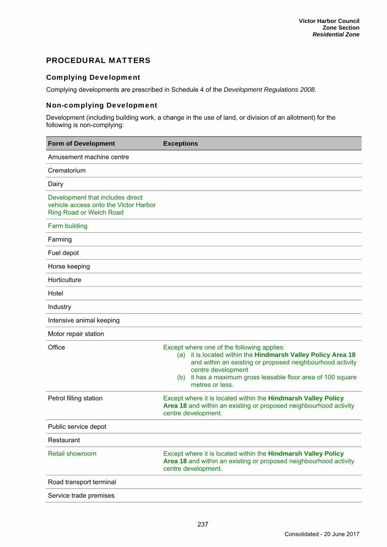
Victor Harbor Council Zone Section
Residential Zone
237
PROCEDURAL MATTERS
Complying Development Complying developments are prescribed in Schedule 4 of the Development Regulations 2008.
Non-complying Development Development (including building work, a change in the use of land, or division of an allotment) for the following is non-complying:
Form of Development Exceptions
Amusement machine centre
Crematorium
Dairy
Development that includes direct vehicle access onto the Victor Harbor Ring Road or Welch Road
Farm building
Farming
Fuel depot
Horse keeping
Horticulture
Hotel
Industry
Intensive animal keeping
Motor repair station
Office Except where one of the following applies: (a) it is located within the Hindmarsh Valley Policy Area 18
and within an existing or proposed neighbourhood activity centre development
(b) it has a maximum gross leasable floor area of 100 square metres or less.
Petrol filling station Except where it is located within the Hindmarsh Valley Policy Area 18 and within an existing or proposed neighbourhood activity centre development.
Public service depot
Restaurant
Retail showroom Except where it is located within the Hindmarsh Valley Policy Area 18 and within an existing or proposed neighbourhood activity centre development.
Road transport terminal
Service trade premises
Consolidated - 20 June 2017

Victor Harbor Council Zone Section Residential Zone
238
Form of Development Exceptions
Shop or group of shops Except where one of the following applies: (a) it is located within the Hindmarsh Valley Policy Area 18
and within an existing or proposed neighbourhood activity centre development
(b) it has a maximum gross leasable floor area of 250 square metres or less.
Stock sales yard
Stock slaughter works
Store
Warehouse
Waste reception, storage, treatment or disposal
Wrecking yard
Public Notification Categories of public notification are prescribed in Schedule 9 of the Development Regulations 2008.
Further, the following forms of development (except where the development is classified as non-complying) are designated:
Category 1 Category 2
Dwellings where the maximum level of fill is no greater than 1.5 metres in height.
A wall where it achieves all of the following: (a) it is located on an allotment boundary (b) it exceeds 3 metres in height (c) the total length of the wall on the boundary
is 8 metres or more.
Demolition of elements of a Heritage Place identified in Table ViH/5 - State Heritage Places or in Table ViH/4 - Local Heritage Places.
Dwellings where the maximum level of cut or fill is greater than 1.5 metres in height.
Consolidated - 20 June 2017

Victor Harbor Council Zone Section
Residential Park Zone
239
Residential Park Zone
Refer to the Map Reference Tables for a list of the maps that relate to this zone.
OBJECTIVES
1 A zone that primarily provides affordable housing opportunities in a landscaped village setting.
2 A zone accommodating low to medium-scale accommodation predominantly in the form of caravan and camping sites, cabins and transportable dwellings, surrounded by open landscaped areas.
3 Development that contributes to the desired character of the zone.
DESIRED CHARACTER
A zone accommodating a range of affordable housing options, within a landscaped setting, that promotes community interaction through its permeable layout, the orientation of buildings, range of shared facilities and quality communal open space.
The zone accommodates a range of low to medium-scale, long-term and short-term accommodation, including camping sites, caravans, relocatable dwellings and cabins.
Buildings, including dwellings, are designed and constructed to enable their relocation, are a maximum of two-storey in height and generously set back from boundaries to allow for landscaped edges of the park. A landscaped village environment will be created.
New development will be sympathetic to the scale, shape, materials and colours of existing adjoining development and landscapes. Vegetation buffers and landscaping will be important in integrating the residential park into the landscape and adjoining urban areas, providing screening from surrounding land uses, as well as reducing visual and noise impacts and providing privacy for park users. The soft landscaping should dominate over buildings and hard surfaces, with caravans only glimpsed in a leafy environment. The park will be enhanced through the further planting of street trees to provide a more leafy and attractive setting and to conceal the built form when viewed from the approaches to the park.
Pedestrian and vehicle linkages provide safe access to employment, shops, public transport facilities, medical services, education facilities, child care and other community facilities. Circulation and movement within the park should be pedestrian friendly and promote low speed vehicle movement.
PRINCIPLES OF DEVELOPMENT CONTROL
Land Use 1 The following forms of development are envisaged in the zone:
▪ amenity block, including shower, toilet, laundry and kitchen facilities ▪ cabin ▪ camping ground ▪ caravan permanently fixed to land ▪ outbuilding ancillary to a dwelling ▪ recreation area ▪ residential park ▪ resident workshop ▪ storage area for recreation vehicle ▪ swimming pool ▪ transportable dwelling.
Consolidated - 20 June 2017

Victor Harbor Council Zone Section Residential Park Zone
240
2 Development listed as non-complying is generally inappropriate.
Form and Character 3 Development should not be undertaken unless it is consistent with the desired character for the zone.
4 Permanent buildings should be limited to a dwelling (manager’s house), shop (in association with and ancillary to a residential park), community or recreational facility and toilets/amenities.
5 Recreation facilities should be provided of a scale that is suitable to maintain the open natural character of the area and ancillary to the primary role and function of the park.
6 At least 16 square metres of contiguous private space, which may be used as a second car parking space, should be provided on each site intended for residential accommodation.
7 Caravan, cabin and dwelling sites should be greater than 100 square metres in area.
8 Landscaping should form an integral part of the design and be used to define spaces, reinforce internal networks, screen utility areas and enhance the visual amenity of the area.
Car Parking and Access 9 Every caravan, cabin or dwelling site should have parking for at least one vehicle, either located on the
site or grouped within the park.
10 Internal road surfaces should be surfaced to prevent dust becoming a nuisance.
Street and Boundary Setbacks 11 Every dwelling, annex or caravan fixed to land should be set back a minimum of:
(a) 1 metre from an internal road
(b) 6 metres from a public road
(c) 2 metres from the boundary of the caravan park or camping ground.
Natural Hazards 12 In areas prone to flooding, bushfire or other natural hazards, buildings and structures (including
annexes attached to caravans or caravans fixed to land) should be designed and constructed so they can be removed in the event of a hazard.
Land Division 13 No additional allotments should be created wholly or partly within the zone except where a lease or
license agreement is made, granted or accepted under the Residential Parks Act 2007.
PROCEDURAL MATTERS
Complying Development Complying developments are prescribed in Schedule 4 of the Development Regulations 2008.
Consolidated - 20 June 2017
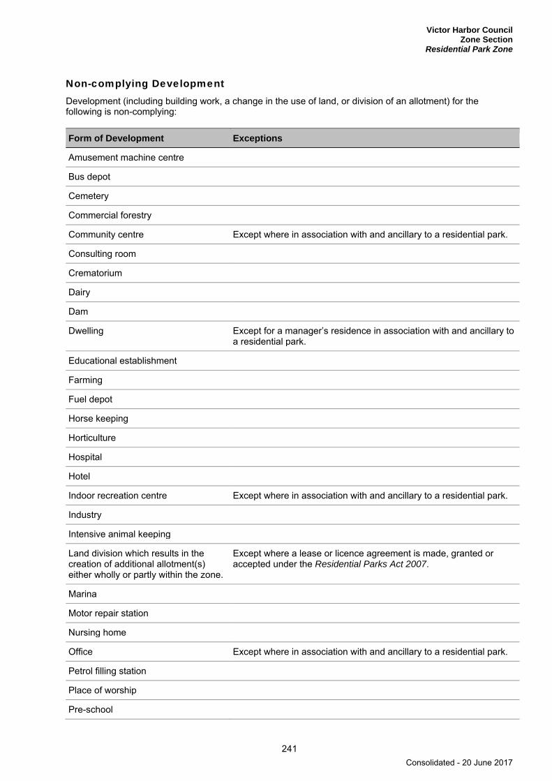
Victor Harbor Council Zone Section
Residential Park Zone
241
Non-complying Development Development (including building work, a change in the use of land, or division of an allotment) for the following is non-complying:
Form of Development Exceptions
Amusement machine centre
Bus depot
Cemetery
Commercial forestry
Community centre Except where in association with and ancillary to a residential park.
Consulting room
Crematorium
Dairy
Dam
Dwelling Except for a manager’s residence in association with and ancillary to a residential park.
Educational establishment
Farming
Fuel depot
Horse keeping
Horticulture
Hospital
Hotel
Indoor recreation centre Except where in association with and ancillary to a residential park.
Industry
Intensive animal keeping
Land division which results in the creation of additional allotment(s) either wholly or partly within the zone.
Except where a lease or licence agreement is made, granted or accepted under the Residential Parks Act 2007.
Marina
Motor repair station
Nursing home
Office Except where in association with and ancillary to a residential park.
Petrol filling station
Place of worship
Pre-school
Consolidated - 20 June 2017

Victor Harbor Council Zone Section Residential Park Zone
242
Form of Development Exceptions
Prescribed mining operations
Public service depot
Residential flat building
Restaurant Except where it is both: (a) less than 150 square metres in gross floor area (b) in association with and ancillary to a residential park.
Road transport terminal
Service trade premises
Shop or group of shops Except where it is both: (a) less than 150 square metres in gross floor area (b) in association with and ancillary to a residential park.
Stadium
Stock sales yard
Stock slaughter works
Store
Warehouse
Waste reception, storage, treatment or disposal
Except where in association with and ancillary to a residential park.
Wrecking yard
Public Notification Categories of public notification are prescribed in Schedule 9 of the Development Regulations 2008.
Further, the following forms of development (except where the development is non-complying) are designated:
Category 1 Category 2
Amenity block, including shower, toilet, laundry and kitchen facilities
Cabin
Camping ground
Caravan permanently fixed to land
Outbuilding
Recreation area
Residential park
Resident workshop
Storage area for recreation vehicle
Swimming pool
Transportable dwelling
Consolidated - 20 June 2017
Victor Harbor Council Zone Section
Rural Living Zone
243
Rural Living Zone
Refer to the Map Reference Tables for a list of the maps that relate to this zone.
OBJECTIVES
1 A zone consisting of large allotments, detached dwellings and rural activities that do not adversely impact the amenity of the locality.
2 Development that contributes to the desired character of the zone.
DESIRED CHARACTER
The zone will accommodate detached dwellings and ancillary small-scale rural activities, whilst maintaining an open rural character. Land will be developed to allow ‘hobby farm’ activities to co-exist with residential living and limited in scale, nature and intensity to be compatible with the amenity of the locality. Development is to have due regard for the environment, including watercourses, natural landforms and local native vegetation.
Land division patterns will provide a variety of allotment sizes, larger than those in the Residential Zone, and consider the natural landform to ensure retention of watercourses, significant ridge tops and indigenous vegetation.
In order to achieve a rural or semi-rural landscape dwellings and structures are envisaged to:
▪ be clustered on each allotment ▪ be designed to be unobtrusive within the landscape ▪ have generous setbacks from all boundaries ▪ reflect land contours ▪ sit below ridgelines and hilltops ▪ be environmentally sustainable with orientation to provide good solar access and ventilation.
Buildings will maintain the rural character by using typical rural materials including non-reflective corrugated galvanized or colour impregnated iron, timber, brick and stone. The design of buildings will reflect the surroundings and utilise natural colours, enabling the structures to blend in with and enhance the surrounding landscape.
Earthworks, driveways and other site works will be minimised, landscaped, screened and designed to complement the landscape.
PRINCIPLES OF DEVELOPMENT CONTROL
Land Use 1 The following forms of development are envisaged in the zone:
▪ detached dwelling ▪ domestic outbuilding in association with a detached dwelling ▪ domestic structure ▪ dwelling addition ▪ farming ▪ farm building ▪ stable.
Consolidated - 20 June 2017
Victor Harbor Council Zone Section Rural Living Zone
244
2 Development listed as non-complying is generally inappropriate.
3 There should be no more than one dwelling per allotment.
4 Non-residential development should be limited in scale, nature and intensity, be ancillary to a residential use and be compatible with the amenity of residential uses in the locality.
5 The keeping of animals should be ancillary to and in association with the residential use of the land.
6 The keeping of horses should only be undertaken if the horses are accommodated within a stable or shelter with supplementary feeding to maintain pasture cover.
Form and Character 7 Development should not be undertaken unless it is consistent with the desired character for the zone.
8 Development should be sited unobtrusively, set-back from roads, and screened with landscaping to ensure that it is not prominently visible from primary or secondary arterial roads, it does not detract from the amenity of the locality and it maintains the open and rural character of the rural landscape.
Horse Keeping 9 Horse keeping should only be undertaken if:
(a) it would not detrimentally affect the character and amenity of the locality
(b) not more than two horses per hectare are kept.
10 Stables and shelters, tack rooms and feed sheds, manure pits and any other building associated with the stabling and keeping of animals should be sited having regard to the following minimum requirements:
(a) 8 metres from any dwelling
(b) 8 metres from every boundary of an allotment
(c) 100 metres from any well
(d) 50 metres from any watercourse.
11 On sites where horses are kept an area should be provided for the loading and unloading of horses, fodder and other goods and materials or wastes brought to or removed from the land.
12 The open space about the stables and yards should be planted or surfaced with a suitable ground cover to minimise dust or erosion.
Consolidated - 20 June 2017

Victor Harbor Council Zone Section
Rural Living Zone Hills Policy Area 26
245
Hills Policy Area 26
Refer to the Map Reference Tables for a list of the maps that relate to this policy area.
OBJECTIVES
1 A policy area consisting of detached dwellings on large allotments and a variety of farming activities including dairying, grazing, horticulture and animal keeping, and other rural uses carried out on a small-scale.
2 Maintenance of the natural skyline and an attractive open rural backdrop to the urban area of Victor Harbor as viewed from that urban area.
3 Residential, recreational and tourist activities developed in a manner which retains the overall rural character of the area and minimises interference with adjoining rural and urban land.
PRINCIPLES OF DEVELOPMENT CONTROL
Land Use 1 The following forms of development are envisaged in the policy area:
▪ animal keeping ▪ detached dwelling ▪ farming ▪ farm building ▪ horticulture.
2 Development should be compatible with the continuation of agricultural activities.
3 Retail, industrial or commercial development should not occur in this policy area unless the activity is associated with the processing of primary production in the locality.
4 The keeping of animals on a commercial basis, and in particular the keeping of pigs, should not occur in or close to the policy area.
Form and Character 5 Dwellings should be single-storey in height or comprise two levels that sit comfortably within the
landscape with a low profile, sited below ridge lines and avoid excessive cut and fill.
6 Development associated with established mining operations should be designed and sited to minimise interference with the surrounding environment and land uses.
7 Dwellings, outbuildings, tanks and other structures should be grouped together to avoid scattered or random siting of structures.
8 To prevent visual intrusion on the escarpment, electricity and telephone lines should be underground.
9 Development should not impair the drainage function or the appearance of the Hindmarsh or Inman Rivers.
Consolidated - 20 June 2017
Victor Harbor Council Zone Section Rural Living Zone Hills Policy Area 26
246
Land Division 10 Division of land should only occur where it achieves one of the following:
(a) no additional allotments are created either partly or wholly within the policy area and the rationalization of allotments will facilitate a use of land consistent with the objectives for the policy area
(b) all resulting allotments are greater than 2 hectares.
11 Land division should not create elongated allotments on the face of the escarpment in a manner which should result in building development in close proximity with adjacent developments on neighbouring allotments.
Consolidated - 20 June 2017
Victor Harbor Council Zone Section
Rural Living Zone Crozier Hill Policy Area 27
247
Crozier Hill Policy Area 27
Refer to the Map Reference Tables for a list of the maps that relate to this policy area.
OBJECTIVES
1 A policy area consisting of detached dwellings on large allotments that provide the opportunity for rural residential and small rural lot pursuits.
2 Development that retains the overall rural character of the area and minimises interference with adjoining rural land.
3 Maintenance of the natural skyline and an attractive open rural backdrop to the urban area of Victor Harbor as viewed from that urban area.
4 Protection of water resources from degradation and pollution.
PRINCIPLES OF DEVELOPMENT CONTROL
Land Use 1 The following forms of development are envisaged in the policy area:
▪ domestic outbuilding ▪ detached dwelling ▪ farming ▪ horse keeping ▪ recreation ▪ stables.
Form and Character 2 Development should be undertaken in accordance with Concept Plan Map ViH/9 - Rural Living (Crozier
Hill).
3 Dwellings and other buildings should be sited on those parts of an allotment that are either devoid or substantially devoid of native vegetation.
4 Buildings and structures, including stables, should be set-back no less than 20 metres from any public road, and 5 metres from any side or rear boundary.
5 Buildings should be sited unobtrusively and screened with landscaping to ensure that the rural character and amenity of the locality is maintained and enhanced.
6 Dwellings and other buildings intended for human habitation should be:
(a) equipped with an adequate and reliable on-site water supply which has a storage capacity equivalent to at least 15 000 litres per bedroom
(b) connected to a suitably designed and constructed effluent disposal system.
7 Areas and facilities used for the storage of fodder should be designed and constructed to prevent infestation by vermin.
8 Horse keeping should only occur on allotments created to the east of and below the ‘50 metre contour’ in accordance with the Concept Plan Map ViH/9 - Rural Living (Crozier Hill).
Consolidated - 20 June 2017

Victor Harbor Council Zone Section Rural Living Zone Crozier Hill Policy Area 27
248
9 Development including buildings and additions to buildings should not be undertaken within the ‘1-in-100 ARI Flood’ extent shown on Concept Plan Map ViH/9 - Rural Living (Crozier Hill).
10 Fences should be designed and located to minimise their impact on the cross sectional volume capacity of the Inman River in the event of a 1-in-100 year average return interval flood event area.
11 The excavation and/or filling of land should be kept to a minimum so as to preserve the natural form of the land and any native vegetation, and should only be undertaken where the capacity of the watercourse or its flood plain is not adversely affected to the detriment of adjoining property owners.
Land Division 12 The division of land should only occur where the resulting allotments have an average size of not less
than 2 hectares.
Consolidated - 20 June 2017

Victor Harbor Council Zone Section
Rural Living Zone Morgan Park Policy Area 28
249
Morgan Park Policy Area 28
Refer to the Map Reference Tables for a list of the maps that relate to this policy area.
OBJECTIVES
1 A policy area consisting of detached dwellings on large allotments that provide the opportunity for people to live and keep horses in a semi-rural environment and undertake other rural living activities compatible with horse keeping.
2 Establishment of equestrian facilities to serve the needs of both local residents and private and public sporting facilities.
PRINCIPLES OF DEVELOPMENT CONTROL
Land Use 1 The following forms of development are envisaged in the policy area:
▪ detached dwelling ▪ domestic outbuilding in association with a detached dwelling ▪ domestic structure ▪ dwelling addition ▪ equestrian facilities ▪ horse keeping ▪ stable.
Form and Character 2 The development of equestrian facilities should be undertaken in appropriate locations and in a manner
that maintains the character and amenity of the policy area.
3 Where a horse is to be kept on an allotment of less than 1 hectare in area the horse should be stabled.
4 Where horses are to be kept on allotments of greater than one hectare in area, the number of horses kept on the allotment and the manner in which they are kept should be consistent with all of the following:
(a) designed and sited so as not to cause undue soil erosion
(b) not require the clearance of, or cause damage to, significant stands of native vegetation
(c) be relative to the size and assimilative capacity of the property with respect to the disposal of wastes.
5 Dwellings should be single-storey in height or comprise two levels that sit comfortably within the landscape with a low profile and avoid excessive cut and fill.
6 To prevent visual intrusion on the escarpment, electricity and telephone lines should be underground.
7 A landscaped buffer area of no less than 10 metres in width should be provided immediately adjacent and along Welch Road reserve.
8 Landscaping should be undertaken in association with development to:
(a) screen structures from public roads
Consolidated - 20 June 2017

Victor Harbor Council Zone Section Rural Living Zone Morgan Park Policy Area 28
250
(b) screen structures from adjoining dwellings
(c) provide protection and shelter for any animals kept on the site.
9 Development should be designed and sited to minimise the impact on the environment and avoid denudation of pastures, or the creation of dust, odour, vermin and noise nuisance.
10 Yards and stables should be designed:
(a) to facilitate regular cleaning
(b) for the collection of surface water that should:
(i) be disposed of in a manner that would not adversely affect neighbouring properties or water resources
(ii) not degrade water resources through the export of sediments, suspended solids, organic matter, nutrients, bacteria and litter in stormwater run-off.
11 Development involving the keeping of horses should be designed to allow for the satisfactory disposal of animal wastes.
12 Wastes produced as a result of the operation of the trotting track, ie wastes generated by public conveniences, stables, holding yards and stormwater emanating from the site, should be disposed of in a manner that will not degrade surface or underground water or in a manner that may generate odour and be a source of annoyance to neighbouring properties.
Land Division 13 Division of land should only occur where the resulting allotments have an average size of not less than
0.5 hectares.
14 All allotments should have direct access on to an equestrian bridle trail which in turn provides a safe and convenient access to the equestrian facilities and the open space area that adjoins the Hindmarsh River.
Consolidated - 20 June 2017

Victor Harbor Council Zone Section
Rural Living Zone Rural Living North Policy Area 29
251
Rural Living North Policy Area 29
Refer to the Map Reference Tables for a list of the maps that relate to this policy area.
OBJECTIVES
1 A policy area consisting of detached dwellings on large allotments in association with farming and other minor rural activities, including horse keeping.
2 The preservation and enhancement of the pleasant rural appearance as derived from the gently undulating pastures, patches of dense scrub, established trees, scattered dwellings and numerous creeks.
PRINCIPLES OF DEVELOPMENT CONTROL
Land Use 1 The following forms of development are envisaged in the policy area:
▪ detached dwelling ▪ domestic outbuilding in association with a detached dwelling ▪ dwelling addition ▪ farming ▪ farm building ▪ horse keeping ▪ stable.
2 The keeping of animals on a commercial basis, and particularly the keeping of pigs, should not occur in the policy area.
3 Industrial, commercial or business (including retail) development should not occur in the policy area.
Land Division 4 Land division should occur where it achieves one of the following:
(a) it is in the form of an alteration or rationalization of allotment boundaries, no additional allotments are created partly or wholly within the zone and the resulting allotments are of a size and shape suitable for the intended use
(b) all new allotments will have a minimum area of 1 hectare.
Consolidated - 20 June 2017

Victor Harbor Council Zone Section Rural Living Zone
252
PROCEDURAL MATTERS
Complying Development Complying developments are prescribed in Schedule 4 of the Development Regulations 2008.
Non-complying Development Development (including building work, a change in the use of land, or division of an allotment) for the following is non-complying:
Form of development Exceptions
Advertisement and/or advertising hoarding
Advertisement and/or advertising hoarding where the development achieves at least one of (a) or (b):
(a) is adjacent to a road with a speed limit of less than 80 km/h (b) has an advertisement area of 2 square metres or less and
achieves all of the following: (i) the message contained thereon relates entirely to a
lawful use of land (ii) the advertisement is erected on the same allotment as
the use it seeks to advertise (iii) the advertisement will not result in more than two
advertisements on the allotment.
Amusement machine centre
Bank
Building or structure Except where it achieves one of the following: (a) it is located in one of the following policy areas:
(i) Hills Policy Area 26 (ii) Morgan Park Policy Area 28 (iii) Rural Living North Policy Area 29
(b) it is located in the Crozier Hill Policy Area 27 and achieves all of the following: (i) it is located below the 110 metres AHD as shown on
Concept Plan Map ViH/9 - Rural Living (Crozier Hill) (ii) service infrastructure facilities cannot be viewed from
Swain Crossing Road (iii) the finished floor level is at least 300 millimetres above
the level of a 1-in-100 year average return interval flood event.
Consulting room
Crematorium
Dairy
Dwelling Except a detached dwelling that results in no more than one dwelling per allotment.
Fuel depot
General industry
Hotel
Intensive animal keeping
Consolidated - 20 June 2017

Victor Harbor Council Zone Section
Rural Living Zone
253
Form of development Exceptions
Landfill that constitutes solid waste disposal required to be licensed as a waste depot under the Environment Protection Act 1993
Light industry
Major public service depot
Motel
Motor repair station
Petrol filling station
Prescribed mining operations
Residential flat building
Restaurant
Road transport terminal
Service trade premises
Shop or group of shops Except where it achieves one of the following: (a) the shop is located in the Morgan Park Policy Area 28 and
has a gross leasable area of 450 square metres or less (b) the shop is located in the Crozier Hill Policy Area 27 and
has a gross leasable area of 50 square metres or less.
Special industry
Stadium
Stock sales yard
Stock slaughter works
Store
Warehouse
Waste reception, storage, treatment or disposal
Wrecking yard
Consolidated - 20 June 2017

Victor Harbor Council Zone Section Rural Living Zone
254
Public Notification Categories of public notification are prescribed in Schedule 9 of the Development Regulations 2008.
Further, the following forms of development (except where the development is classified as non-complying) are designated:
Category 1 Category 2
Within the Crozier Hill Policy Area 27: (a) alterations and additions to existing
development (b) dwelling (c) farming (d) horse keeping (e) recreation (f) shed, garage or residential outbuilding
associated with an existing dwelling on the same site.
Demolition of elements of a Heritage Place identified in Table ViH/5 - State Heritage Places or in Table ViH/4 - Local Heritage Places. Horticulture where it is located within the Crozier Hill Policy Area 27.
Consolidated - 20 June 2017
Victor Harbor Council Zone Section
Suburban Neighbourhood Zone
255
Suburban Neighbourhood Zone
Refer to the Map Reference Tables for a list of the maps that relate to this zone.
OBJECTIVES
1 A predominantly low and medium density residential area that comprises a range of dwelling types together with local and neighbourhood activity centres that are located within a walkable distance of most residents.
2 Provision of medium density residential development adjacent to activity centres, public transport stops and public open space.
3 Affordable housing that is integrated into residential and mixed use development.
4 Local and neighbourhood activity centres that provide a range of shopping, community, business and recreational facilities for the surrounding neighbourhood.
5 The orderly expansion or intensification of urban areas to support the effective and economic provision of public infrastructure and community services.
6 Sustainable development outcomes through innovation in stormwater management, waste minimisation, water conservation, energy efficiency and urban biodiversity.
7 Development on sloping land designed to minimise environmental and visual impacts and protect soil stability and water quality.
8 Development that contributes to the desired character of the zone.
DESIRED CHARACTER
This zone will be developed as low and medium density residential neighbourhood established around a neighbourhood-scale activity centre. The layout of the area will create active public spaces and provide equitable access to public open space, shops, education facilities and a range of community services.
Housing diversity is a priority for the zone and a range of affordable and social housing products will also be delivered through innovative land division layout, housing design, access and parking arrangements. Affordable housing will be integrated and complementary in design and appearance to other dwellings within the development. Affordable housing will be integrated and complementary in design and appearance to other dwellings within the development.
Dwellings will be up to 2 storeys with an average net residential density of around 30 to 45 dwellings per hectare. Higher density buildings with a net residential density of around 45 to 70 dwellings per hectare, which may including taller buildings up to 3 storeys, are envisaged within and directly adjacent to activity centres or directly abutting public open spaces greater than 2000 square metres.
A neighbourhood activity centre is envisaged within the zone on Concept Plan Map ViH/14 - Suburban Neighbourhood (Encounter Bay), containing in the order of 6000 square metres of retail floor space, in addition to other business and community facilities. The neighbourhood activity centre will be located to encourage access via a network of pedestrian and bicycle linkages, and will serve a broader area beyond the Zone.
Street level uses will be primarily retail, service and office. Upper floor land uses will primarily be residential with some office accommodation. Features and activities that attract people to activity centres are encouraged, such as frequent doors and display windows, retail shopfronts and outdoor eating or dining
Consolidated - 20 June 2017
Victor Harbor Council Zone Section Suburban Neighbourhood Zone
256
areas spilling out onto footpaths. A distinctive urban form, adjacent to and within activity centres, will frame squares and courtyards and reinforce a main-street theme.
Activity centres will have a pedestrian friendly environment with wide footpaths, colonnades, courtyards, awnings and street furniture. Public and communal spaces will encourage community interaction and no or low fencing on road frontages will promote casual surveillance. Parking areas will be sited behind buildings, where possible, to reinforce the pedestrian feel.
Street patterns and walkways will be integral to subdivision. Neighbourhood design will encourage active travel such as walking and cycling to local services and facilities.
Open space will be provided away from potential noise sources. Public open space will be designed as safe and attractive places for a range of recreational activities and formal sport as well as water management and environmental protection.
Water Sensitive Urban Design systems, including the harvest, treatment, storage and reuse of storm water, will be integrated throughout the area at the neighbourhood, street, site and building level. Harvested storm water will improve the aesthetic and functional value of open spaces, including public access ways and greenways.
Areas within the Zone on the upper slopes are identified as being subject to Medium Bushfire Risk provisions and adjoin an area of High Bushfire Risk to the west. Land division will therefore ensure that access is available for fire-fighting personnel from the Zone to the adjoining High Bushfire Risk Area. It is expected that larger allotments and lower density development will be provided in this area taking into account the slope of the land and to assist in mitigating bushfire risk. A buffer of reduced vegetation should be established along the boundary of the zone adjacent to the area of High Bushfire Risk.
The upper slopes of the zone form a backdrop to Victor Harbor and Encounter Bay. It also includes land with steeper gradients (above 1 in 5 or more), as indicated by the area for ‘Low Density Residential’ on Concept Plan Figure SN/1. Development in these areas of the Zone will incorporate minimal cut and fill and be designed and landscaped (without compromising bushfire protection measures) to minimise the visual impact of the area when viewed from the lower lying areas to the east. Single storey development in these areas is preferred unless the building is designed to follow the contours of the land (i.e. stepped level development).
An existing quarry operates within a tenement to the north of the zone. These mining operations may shift southwards closer to the zone to access potential mineral resources located to the south and outside of the existing tenement boundary. While existing housing and rural living areas to the north and west of the zone are already located within guideline separation distances for quarry activities, the land division layout should minimise (or preferably avoid) increasing the number of dwellings within 400 metres of the potential mineral resource area shown on Concept Plan Map ViH/14 - Suburban Neighbourhood (Encounter Bay).
PRINCIPLES OF DEVELOPMENT CONTROL
Land Use 1 The following forms of development are envisaged in the zone:
▪ affordable housing ▪ aged persons accommodation ▪ community facility ▪ consulting room ▪ domestic outbuilding ▪ dwelling ▪ educational establishment ▪ indoor recreation centre ▪ office ▪ pre-school ▪ primary school
Consolidated - 20 June 2017
Victor Harbor Council Zone Section
Suburban Neighbourhood Zone
257
▪ residential flat building ▪ shop or group of shops, excluding a bulky goods outlet or a retail showroom. ▪ supported accommodation.
2 The following additional forms of development are envisaged in the designated neighbourhood activity centre, identified on on Concept Plan Map ViH/14 - Suburban Neighbourhood (Encounter Bay):
▪ bulky goods outlet ▪ petrol filling station ▪ place of worship.
3 Development should be in accordance with Concept Plan Map ViH/14 - Suburban Neighbourhood (Encounter Bay).
4 Non-residential development should be located within designated neighbourhood activity centres except where comprising small scale uses that:
(a) serve the local community
(b) are of a nature and scale consistent with the character of the locality
(c) do not compromise the capacity to achieve coordinated activity centre development
(d) do not detrimentally impact on the amenity of nearby residents.
5 Development should not be in the form of entertainment venues and/or licensed premises that provide live music.
6 Development listed as non-complying is generally inappropriate.
Form and Character 7 Development should not be undertaken unless it is consistent with the desired character for the zone.
8 Development of three or more storeys in height should ensure that:
(a) north-facing windows to habitable rooms of existing dwelling(s) on the same allotment, and on adjacent allotments, receive at least 3 hours of direct sunlight over a portion of their surface between 9.00 am and 3.00 pm on 21 June
(b) ground level open space of existing buildings receives direct sunlight for a minimum of 2 hours between 9.00 am and 3.00 pm on 21 June to at least the smaller of the following:
(i) half of the existing ground level open space
(ii) 35 square metres of the existing ground level open space (with at least one of the area’s dimensions measuring 2.5 metres).
9 Development should be 2 storeys or less except where located in or adjacent to a designated activity centre or adjacent to public open space as identified on on Concept Plan Map ViH/14 - Suburban Neighbourhood (Encounter Bay) where development should be 3 storeys or less.
10 The visual massing and height of buildings in activity centres should be progressively reduced at the interface with lower density residential development.
Building to the Side Boundary 11 Walls of dwellings and residential flat buildings sited on side boundaries should be in accordance with at
least one of the following:
Consolidated - 20 June 2017

Victor Harbor Council Zone Section Suburban Neighbourhood Zone
258
(a) be located immediately abutting the wall of an existing or simultaneously constructed building on the adjoining land to the same or lesser length and height
(b) constructed in accordance with any approved building envelope plan
(c) the exposed section of the wall is less than 8 metres in length and 3.5 metres in height.
12 Dwellings developed to both side boundaries, except where there is less than 25 square metres of private open space, should provide ground level access to the rear of the site via a carport, garage, access way, service lane or the like.
Setbacks from the Side Boundary 13 Walls of dwellings set back from the side boundary should be designed in accordance with the
following:
Wall height (measured from natural ground level)
Minimum setback from side boundaries (metres)
For any portion of the wall less than or equal to 7 metres 0.9
For any portion of the wall greater than 7 metres 2
Front Setbacks 14 Dwellings and residential flat buildings (excluding verandas, porticos and the like) should be set back
from road frontages in accordance with the following parameters:
Minimum setback Value (metres)
From the primary road frontage of an arterial road
8 or the average of any existing dwellings on any adjoining allotments with the same primary frontage (or, if there is only one such dwelling, the setback of that dwelling)
From the primary road frontage of all other roads
3 or the average of any existing dwellings on any adjoining allotments with the same primary frontage (or, if there is only one such dwelling, the setback of that dwelling)
1.5 where the allotment is located adjacent to a public reserve greater than 2000 square metres, the dwelling faces that reserve and vehicle access is provided to the rear of the allotment
No minimum where the land is within or directly facing a designated activity centre and vehicle access is provided to the rear of the allotment
From a secondary road frontage that is an arterial road
8 or the average of any existing dwellings on any adjoining allotments with the same primary frontage (or, if there is only one such dwelling, the setback of that dwelling)
Minimum setback to a secondary road frontage that is not an arterial road
0.9
Setbacks from Rear Boundaries 15 The walls of detached, semi-detached and row dwellings should be set back from rear boundaries,
except where the rear boundary adjoins an access way, in accordance with the following parameters:
Consolidated - 20 June 2017

Victor Harbor Council Zone Section
Suburban Neighbourhood Zone
259
Allotment size (square metres)
Ground floor minimum setback (metres)
Second storey minimum setback (metres)
Third storey or more minimum setback (metres)
≤300 2 5 5 plus any increase in wall height over 6 metres
>300 3 5 5 plus any increase in wall height over 6 metres
16 Walls of dwellings and residential flat buildings sited on rear boundaries should be in accordance with at least one of the following:
(a) be located immediately abutting the wall of an existing or simultaneously constructed building on the adjoining land to the same or lesser length and height
(b) constructed in accordance with any approved building envelope plan.
Site Area 17 Other than within the ‘low density area’ as shown on on Concept Plan Map ViH/14 - Suburban
Neighbourhood (Encounter Bay) a dwelling should have a minimum site area (and in the case of residential flat buildings, an average site area per dwelling) and a frontage to a public road not less than that shown in the following table:
Dwelling type Minimum area (square metres) Minimum frontage (metres)
Detached (except where constructed boundary to boundary)
250 minimum allotment area 7
Semi-detached 200 minimum allotment area 6
Row dwelling and detached dwelling constructed boundary to boundary
125 minimum allotment area 5
Group dwellings and/residential flat building (1 and 2 storey)
200 average site area per dwelling No minimum
18 Other than within the ‘low density area’ as shown on on Concept Plan Map ViH/14 - Suburban Neighbourhood (Encounter Bay), the minimum site area requirements specified can be reduced where the division is accompanied by a building envelope plan detailing building footprints and wall heights that demonstrates that the development contributes to the desired character of the zone and where one of the following applies:
(a) the allotment(s) is located within 200 metres of a neighbourhood activity centre
(b) the development includes 15 per cent affordable housing
(c) the allotment(s) is directly adjacent public open space greater than 2000 square metres.
19 Residential development within the ‘low density residential’ area shown on Concept Plan Map ViH/14 - Suburban Neighbourhood (Encounter Bay) should consist only of detached dwellings on allotments of not less than 1500 square metres.
Local and Neighbourhood Activity Centres 20 The neighbourhood activity centre identified on Concept Plan Map ViH/14 - Suburban Neighbourhood
(Encounter Bay) should be of a scale and distribution that does not impede the development of the Victor Harbor Town Centre and be established within the zone such that it maximises the number of households in the wider area that are within walking distance.
Consolidated - 20 June 2017

Victor Harbor Council Zone Section Suburban Neighbourhood Zone
260
21 Designated local and neighbourhood activity centres should:
(a) maximise their role as a neighbourhood focus by including a range of community facilities
(b) be physically connected with surrounding residential areas by:
(i) avoiding large expanses of vehicle parking that physically separates the activity centre from surrounding residential areas
(ii) including pedestrian and cycle linkages that enable residents to comfortably walk and cycle directly from residential areas to and also within activity centre facilities
(c) orient development towards and near to public spaces and street frontages
(d) incorporate, where possible, mixed use development along the edges to provide a transition from activity centre uses to residential areas
(e) include shelter for pedestrians along public streets and internal access ways
(f) ensure building façades create diversity of interest and have the appearance of an aggregation of small buildings
(g) ensure roof forms are varied and do not include large expanses of roofline that are visible from the public domain
(h) ensure buildings address the street frontage and open spaces with servicing areas generally accessed via rear lanes or internal to the activity centre and not visible from public streets.
22 Development within designated activity centres should be set back a maximum of 3 metres from the primary road frontage.
Sloping Land 23 Development including roads and associated driveways should be sited and designed to integrate with
the natural topography of the land and minimise the need for earthworks.
24 Development including roads and associated driveways, including related earthworks, should be sited, designed and undertaken in a manner that:
(a) minimises their visual impact
(b) reduces the bulk of the buildings and structures
(c) minimises the extent of cut and/or fill
(d) minimises the need for, and the height of, retaining walls
(e) does not cause or contribute to instability of any embankment or cutting
(f) avoids the silting of watercourses
(g) protects development and its surrounds from erosion caused by water runoff.
25 Driveways across sloping land should be accessible and have a safe, all-weather trafficable surface.
26 Development sites should not be at risk of landslip.
27 Development on steep land should include site drainage systems to minimise erosion and avoid adverse impacts on slope stability.
Consolidated - 20 June 2017

Victor Harbor Council Zone Section
Suburban Neighbourhood Zone
261
28 Steep sloping sites in un-sewered areas should not be developed unless the physical characteristics of the allotments enable the proper siting and operation of an effluent drainage field suitable for the development intended.
29 The cutting and/or filling of land should:
(a) be kept to a minimum and be limited to a maximum depth or height no greater than 1.5 metres so as to preserve the natural form of the land and the native vegetation
(b) only be undertaken in order to reduce the visual impact of buildings, including structures, or in order to construct water storage facilities for use on the allotment
(c) only be undertaken if the resultant slope can be stabilised to prevent erosion
(d) result in stable scree slopes which are covered with top soil and landscaped so as to preserve and enhance the natural character or assist in the re-establishment of the natural character of the area.
Hazards 30 To protect against bushfire, dwellings should not be sited within 40 metres of a slope greater than 20
degrees, where the length of the slope is greater than 10 metres and covered by hazardous vegetation.
31 The Medium Bushfire Risk classification will apply to development in those parts of the zone shown as Excluded in Bushfire Protection Area BPA Maps – Bushfire Risk, if any of the following apply:
(a) the development does not form part of the contiguous urban area
(b) the development is on an allotment that is not connected to a mains water supply.
Land Division 32 Land division should identify an allotment capable of accommodating an activity centre in the location
identified on Concept Plan Map ViH/14 - Suburban Neighbourhood (Encounter Bay).
PROCEDURAL MATTERS
Complying Development Complying developments are prescribed in Schedule 4 of the Development Regulations 2008.
Non-complying Development Development (including building work, a change in the use of land, or division of an allotment) for the following is non-complying:
Form of development Exceptions
Crematorium
Dairy
Farming
Fuel depot
Horse keeping
Horticulture
Hospital
Consolidated - 20 June 2017
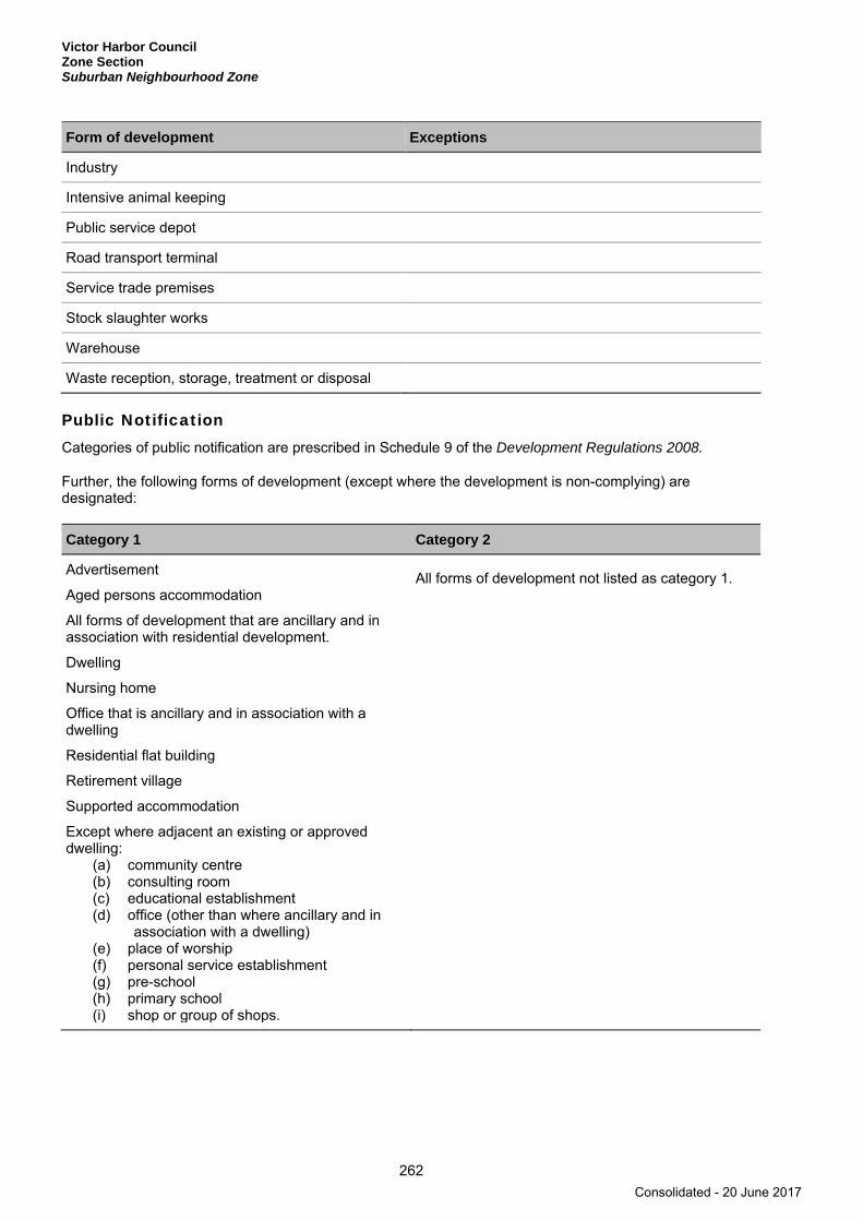
Victor Harbor Council Zone Section Suburban Neighbourhood Zone
262
Form of development Exceptions
Industry
Intensive animal keeping
Public service depot
Road transport terminal
Service trade premises
Stock slaughter works
Warehouse
Waste reception, storage, treatment or disposal
Public Notification Categories of public notification are prescribed in Schedule 9 of the Development Regulations 2008.
Further, the following forms of development (except where the development is non-complying) are designated:
Category 1 Category 2
Advertisement
Aged persons accommodation
All forms of development that are ancillary and in association with residential development.
Dwelling
Nursing home
Office that is ancillary and in association with a dwelling
Residential flat building
Retirement village
Supported accommodation
Except where adjacent an existing or approved dwelling:
(a) community centre (b) consulting room (c) educational establishment (d) office (other than where ancillary and in
association with a dwelling) (e) place of worship (f) personal service establishment (g) pre-school (h) primary school (i) shop or group of shops.
All forms of development not listed as category 1.
Consolidated - 20 June 2017

Victor Harbor Council Zone Section
Tourist Accommodation Zone
263
Tourist Accommodation Zone
Refer to the Map Reference Tables for a list of the maps that relate to this zone.
OBJECTIVES
1 A zone consisting of tourist accommodation and related recreational and community facilities.
2 Development that contributes to the desired character of the zone.
DESIRED CHARACTER
The zone provides a range of tourist accommodation and related recreational and community facilities in close proximity to areas of interest (Inman River and Bluff Reserve).
Tourist accommodation and related facilities will be of high quality, integrated into the landscape and compatible to the environmental qualities within the zone. Design elements including building scale, articulation, orientation, height, colour and materials are to be compatible within the local context. Generous landscaping using local native vegetation is to be provided to soften the built form, provide a more natural appearance and extension of surrounding remnant vegetation, and reduce demands on local water resources.
Development needs to consider the potential for local area flooding of the Inman River and sea level rises along the coast.
Vehicle access and car parking are to be sited and designed to have minimal detrimental impacts on the public realm and to surrounding residential properties.
Pedestrian and cycling accessibility and permeability is essential, both with these areas and to/from adjoining surrounding areas.
PRINCIPLES OF DEVELOPMENT CONTROL
Land Use 1 The following forms of development are envisaged in the zone:
▪ amenity block including shower, toilet and laundry facilities ▪ recreation area ▪ recreation facilities ▪ tourist accommodation ▪ tourist facilities.
2 Development listed as non-complying is generally inappropriate.
Form and Character 3 Development should not be undertaken unless it is consistent with the desired character for the zone.
4 Development should be designed and sited to minimise its visual impact on the coast and retain the visual and environmental qualities of the zone.
5 Development should be sited unobtrusively, set-back from roads, and screened with landscaping to ensure that it is not prominently visible from primary or secondary arterial roads, it does not detract from the amenity of the locality and it maintains the open character of the rural landscape.
Consolidated - 20 June 2017

Victor Harbor Council Zone Section Tourist Accommodation Zone Inman River Tourist Recreation Policy Area 30
264
Inman River Tourist Recreation Policy Area 30
Refer to the Map Reference Tables for a list of the maps that relate to this policy area.
OBJECTIVES
1 A policy area consisting of tourist, recreational and community facilities that are compatible with the sensitivity of the estuarine environment and the flood-prone nature of the land.
PRINCIPLES OF DEVELOPMENT CONTROL
Land Use 1 Development should comprise of tourist accommodation and related tourist services, community and
recreational facilities.
Form and Character 2 Buildings should have a maximum height of no more than 9 metres or two storeys above natural ground
level.
3 Development should be located and designed to minimise visual intrusion on the natural appearance of the Inman River and its environs.
4 Development should be designed and sited to minimise any impact from the flood-prone nature of land adjoining the Inman River.
Consolidated - 20 June 2017
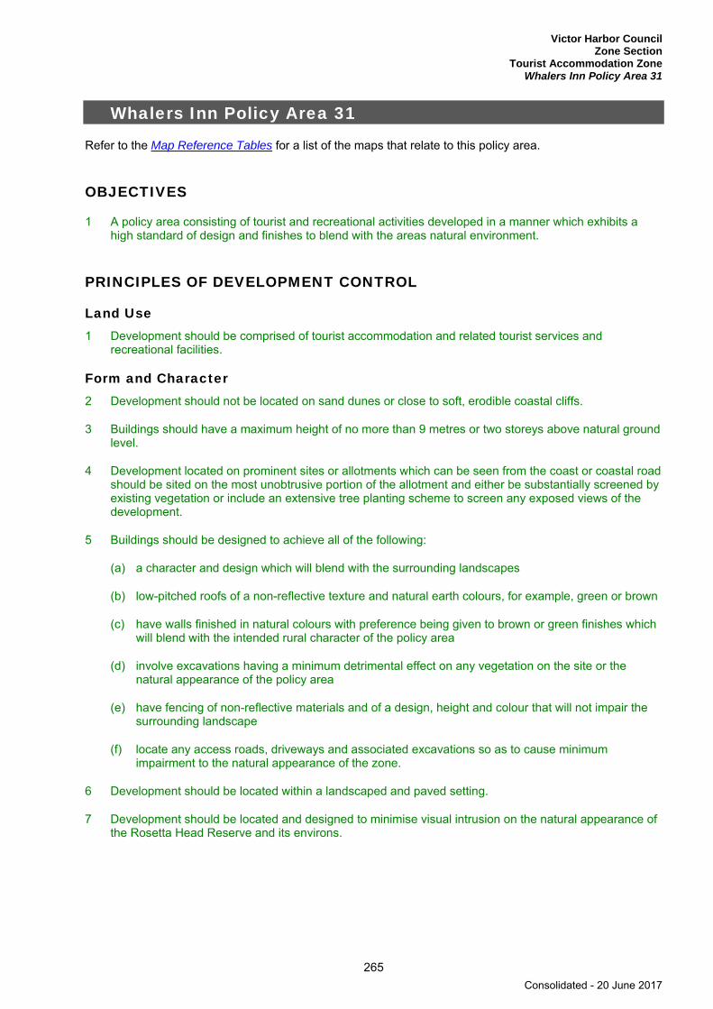
Victor Harbor Council Zone Section
Tourist Accommodation Zone Whalers Inn Policy Area 31
265
Whalers Inn Policy Area 31
Refer to the Map Reference Tables for a list of the maps that relate to this policy area.
OBJECTIVES
1 A policy area consisting of tourist and recreational activities developed in a manner which exhibits a high standard of design and finishes to blend with the areas natural environment.
PRINCIPLES OF DEVELOPMENT CONTROL
Land Use 1 Development should be comprised of tourist accommodation and related tourist services and
recreational facilities.
Form and Character 2 Development should not be located on sand dunes or close to soft, erodible coastal cliffs.
3 Buildings should have a maximum height of no more than 9 metres or two storeys above natural ground level.
4 Development located on prominent sites or allotments which can be seen from the coast or coastal road should be sited on the most unobtrusive portion of the allotment and either be substantially screened by existing vegetation or include an extensive tree planting scheme to screen any exposed views of the development.
5 Buildings should be designed to achieve all of the following:
(a) a character and design which will blend with the surrounding landscapes
(b) low-pitched roofs of a non-reflective texture and natural earth colours, for example, green or brown
(c) have walls finished in natural colours with preference being given to brown or green finishes which will blend with the intended rural character of the policy area
(d) involve excavations having a minimum detrimental effect on any vegetation on the site or the natural appearance of the policy area
(e) have fencing of non-reflective materials and of a design, height and colour that will not impair the surrounding landscape
(f) locate any access roads, driveways and associated excavations so as to cause minimum impairment to the natural appearance of the zone.
6 Development should be located within a landscaped and paved setting.
7 Development should be located and designed to minimise visual intrusion on the natural appearance of the Rosetta Head Reserve and its environs.
Consolidated - 20 June 2017

Victor Harbor Council Zone Section Tourist Accommodation Zone
266
PROCEDURAL MATTERS
Complying Development Complying developments are prescribed in Schedule 4 of the Development Regulations 2008.
Non-complying Development Development (including building work, a change in the use of land, or division of an allotment) for the following is non-complying:
Form of development Exceptions
Building where it is located in the Whalers Inn Policy Area 31
Except where it is no more than 9 metres in height above average natural ground level.
Commercial forestry
Consulting room
Dwelling
Farming
Farm building
Fuel depot
Horticulture
Industry
Intensive animal keeping
Motor repair station
Motor showroom
Prescribed mining operations
Road transport terminal
Shop or group of shops with a gross leasable floor area greater than 450 square metres
Stock sales yard
Stock slaughter works
Store
Timber yard
Warehouse
Waste reception, storage, treatment or disposal
Wrecking yard
Consolidated - 20 June 2017

Victor Harbor Council Zone Section
Tourist Accommodation Zone
267
Public Notification Categories of public notification are prescribed in Schedule 9 of the Development Regulations 2008.
Further, the following forms of development (except where the development is non-complying) are designated:
Category 1 Category 2
Demolition of elements of a Heritage Place identified in Table ViH/5 - State Heritage Places or in Table ViH/4 - Local Heritage Places.
Consolidated - 20 June 2017

Victor Harbor Council Zone Section Watershed Protection (Mount Lofty Ranges) Zone
268
Watershed Protection (Mount Lofty Ranges) Zone
Refer to the Map Reference Tables for a list of the maps that relate to this zone.
OBJECTIVES
1 Provision of a safe drinking water supply to Adelaide by improving the quality and quantity of water harvested from the Mount Lofty Ranges Watershed.
2 Protection of unused catchments in the Mount Lofty Ranges Watershed from inappropriate development which may jeopardize their future use for water supply.
3 Development liable to contribute to the pollution or reduction of surface and/or underground water resources excluded from the zone.
4 Extensive areas of native vegetation to safeguard the catchment and recharge characteristics of the water resource.
5 A zone primarily for farming activities on large land holdings that do not pollute water resources.
6 Development that contributes to the desired character of the zone.
DESIRED CHARACTER
The watershed area is of critical importance to South Australia as it provides on average 60 per cent of Adelaide’s water supply. The zone contains catchment areas for existing as well as proposed reservoirs serving metropolitan Adelaide and the surrounding areas. Land within the zone is also used for a range of purposes including living, rural primary production, and conservation.
The quality of water entering existing reservoirs from the catchments is poor and often does not meet established guideline values. This poor water quality has been linked to the cumulative effects of a large number of small pollution sources. The maintenance and enhancement of water quality and prevention of pollution are of the highest priority in this zone. Strict control of development in the watershed is necessary to ensure a continued economic supply of safe drinking water.
Small scale wineries, low impact agriculture and home based industries are encouraged where they expand the economic base of the South Mount Lofty Ranges Region. Home based industries involving rural, arts, crafts, tourist, cultural and heritage activities are suitable. Small scale tourist development tailored to the local rural amenity and environment are envisaged instead of larger tourism development and related retail activities that are to remain within townships and centres.
Conservation of native vegetation is to occur within the Region to allow for habitat and species protection, landscape amenity, water quality maintenance and soil stability.
PRINCIPLES OF DEVELOPMENT CONTROL
1 Development should not adversely affect the quality or quantity of water resources.
Land Use 2 The following forms of development are envisaged in the zone:
▪ commercial forestry▪ grazing
Consolidated - 20 June 2017
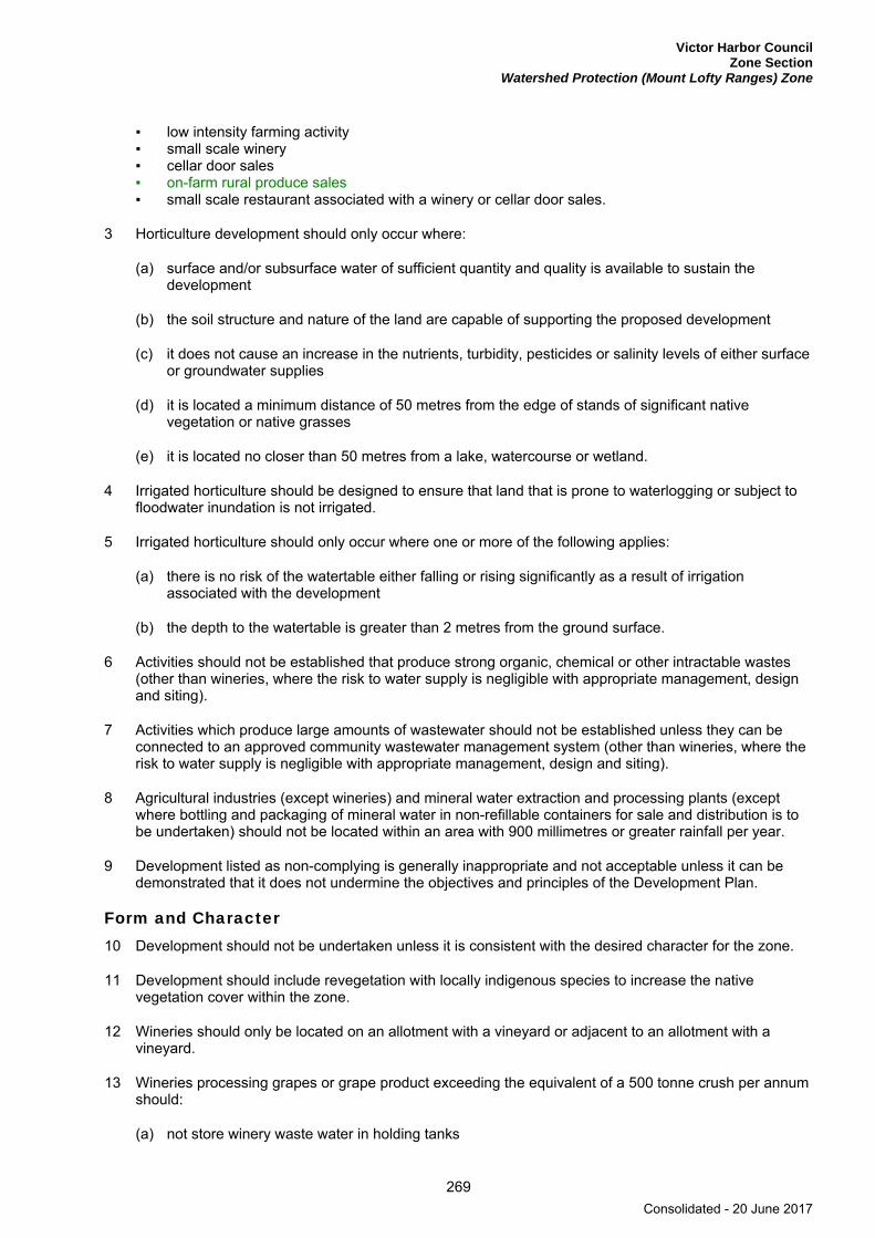
Victor Harbor Council Zone Section
Watershed Protection (Mount Lofty Ranges) Zone
269
▪ low intensity farming activity ▪ small scale winery ▪ cellar door sales ▪ on-farm rural produce sales ▪ small scale restaurant associated with a winery or cellar door sales.
3 Horticulture development should only occur where:
(a) surface and/or subsurface water of sufficient quantity and quality is available to sustain the development
(b) the soil structure and nature of the land are capable of supporting the proposed development
(c) it does not cause an increase in the nutrients, turbidity, pesticides or salinity levels of either surface or groundwater supplies
(d) it is located a minimum distance of 50 metres from the edge of stands of significant native vegetation or native grasses
(e) it is located no closer than 50 metres from a lake, watercourse or wetland.
4 Irrigated horticulture should be designed to ensure that land that is prone to waterlogging or subject to floodwater inundation is not irrigated.
5 Irrigated horticulture should only occur where one or more of the following applies:
(a) there is no risk of the watertable either falling or rising significantly as a result of irrigation associated with the development
(b) the depth to the watertable is greater than 2 metres from the ground surface.
6 Activities should not be established that produce strong organic, chemical or other intractable wastes (other than wineries, where the risk to water supply is negligible with appropriate management, design and siting).
7 Activities which produce large amounts of wastewater should not be established unless they can be connected to an approved community wastewater management system (other than wineries, where the risk to water supply is negligible with appropriate management, design and siting).
8 Agricultural industries (except wineries) and mineral water extraction and processing plants (except where bottling and packaging of mineral water in non-refillable containers for sale and distribution is to be undertaken) should not be located within an area with 900 millimetres or greater rainfall per year.
9 Development listed as non-complying is generally inappropriate and not acceptable unless it can be demonstrated that it does not undermine the objectives and principles of the Development Plan.
Form and Character 10 Development should not be undertaken unless it is consistent with the desired character for the zone.
11 Development should include revegetation with locally indigenous species to increase the native vegetation cover within the zone.
12 Wineries should only be located on an allotment with a vineyard or adjacent to an allotment with a vineyard.
13 Wineries processing grapes or grape product exceeding the equivalent of a 500 tonne crush per annum should:
(a) not store winery waste water in holding tanks
Consolidated - 20 June 2017
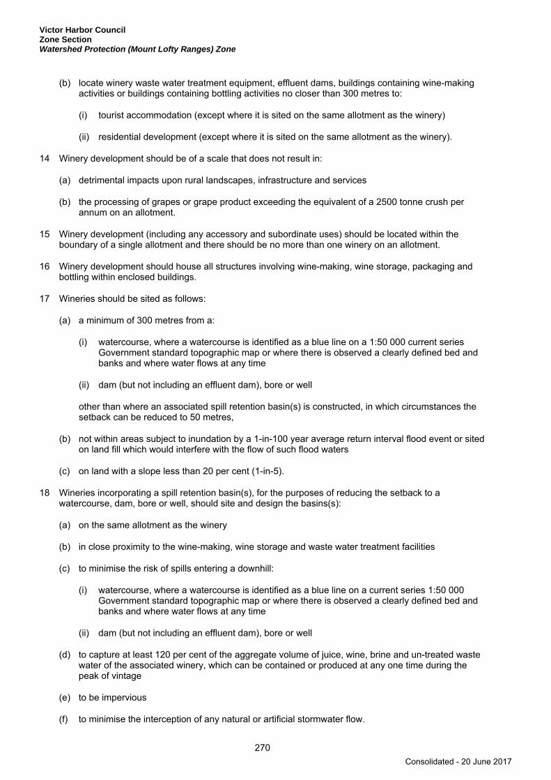
Victor Harbor Council Zone Section Watershed Protection (Mount Lofty Ranges) Zone
270
(b) locate winery waste water treatment equipment, effluent dams, buildings containing wine-making activities or buildings containing bottling activities no closer than 300 metres to:
(i) tourist accommodation (except where it is sited on the same allotment as the winery)
(ii) residential development (except where it is sited on the same allotment as the winery).
14 Winery development should be of a scale that does not result in:
(a) detrimental impacts upon rural landscapes, infrastructure and services
(b) the processing of grapes or grape product exceeding the equivalent of a 2500 tonne crush per annum on an allotment.
15 Winery development (including any accessory and subordinate uses) should be located within the boundary of a single allotment and there should be no more than one winery on an allotment.
16 Winery development should house all structures involving wine-making, wine storage, packaging and bottling within enclosed buildings.
17 Wineries should be sited as follows:
(a) a minimum of 300 metres from a:
(i) watercourse, where a watercourse is identified as a blue line on a 1:50 000 current series Government standard topographic map or where there is observed a clearly defined bed and banks and where water flows at any time
(ii) dam (but not including an effluent dam), bore or well
other than where an associated spill retention basin(s) is constructed, in which circumstances the setback can be reduced to 50 metres,
(b) not within areas subject to inundation by a 1-in-100 year average return interval flood event or sited on land fill which would interfere with the flow of such flood waters
(c) on land with a slope less than 20 per cent (1-in-5).
18 Wineries incorporating a spill retention basin(s), for the purposes of reducing the setback to a watercourse, dam, bore or well, should site and design the basins(s):
(a) on the same allotment as the winery
(b) in close proximity to the wine-making, wine storage and waste water treatment facilities
(c) to minimise the risk of spills entering a downhill:
(i) watercourse, where a watercourse is identified as a blue line on a current series 1:50 000 Government standard topographic map or where there is observed a clearly defined bed and banks and where water flows at any time
(ii) dam (but not including an effluent dam), bore or well
(d) to capture at least 120 per cent of the aggregate volume of juice, wine, brine and un-treated waste water of the associated winery, which can be contained or produced at any one time during the peak of vintage
(e) to be impervious
(f) to minimise the interception of any natural or artificial stormwater flow.
Consolidated - 20 June 2017
Victor Harbor Council Zone Section
Watershed Protection (Mount Lofty Ranges) Zone
271
19 Wineries involving the on-site treatment and disposal of waste water should:
(a) connect to a system capable of treating the winery waste water to a biological oxygen demand (BOD) of less than 100 milligrams per litre before it is stored in the open for more than 48 hours
(b) dispose the treated winery waste water to a suitable irrigation field
(c) mound the irrigation field in a manner that would direct excess effluent runoff to a spill retention basin(s) and minimise the potential for treated waste water to enter:
(i) an adjacent allotment
(ii) public land
(iii) a watercourse, where a watercourse is identified as a blue line on a 1:50 000 current series Government standard topographic map or where there is observed a clearly defined bed and banks and where water flows at any time
(iv) a dam (but not including an effluent dam), bore or well.
20 Winery waste water holding tanks should:
(a) have a total storage capacity of more than four days total flow during the peak of vintage
(b) be contained within an impervious, bunded area having a total liquid holding capacity of more than 120 per cent of the total holding tank capacity.
21 Wineries should:
(a) incorporate all-weather on-site parking (including for commercial vehicles) with safe and convenient access for staff and visitors
(b) utilise existing buildings except where a new building would minimise detrimental environmental impacts
(c) process primary produce that is grown within the Mount Lofty Ranges Region and sell goods manufactured and produced by the industry
(d) enhance the rural/agricultural character and/or heritage features and tourist activities of the Mount Lofty Ranges Region.
22 Wineries should not:
(a) necessitate significant upgrading of public infrastructure including roads and other utilities, unless upgrading would be required through normal maintenance or was imminent due to growth in demand in the locality
(b) generate traffic beyond the capacity of roads necessary to service the development
(c) result in traffic volumes that would be likely to adversely alter the character and amenity of the locality
(d) generate significant additional traffic noise or other nuisance which would detract from resident’s or other land holder’s enjoyment of the locality
(e) generate noise of greater than 40 decibels during the hours of 10.00 pm to 7.00 am and 47 decibels between 7.00 am to 10.00 pm respectively as measured at the nearest neighbouring dwelling or boundary of a vacant allotment.
Consolidated - 20 June 2017

Victor Harbor Council Zone Section Watershed Protection (Mount Lofty Ranges) Zone
272
23 Restaurants should:
(a) be established on the same allotment as, and be visually associated with a winery or shop where the tasting of wine and retail sale of wine are the predominant activities and where the sale of wine is limited to that which is uniquely the licensee’s own product
(b) not result in more than 75 seats for customer dining purposes on the allotment
(c) not result in a gross leasable area of greater than 25 square metres for the display and sale of any non-beverage or non-food items on the allotment.
24 Cellar door sales outlets should:
(a) be established on the same allotment as a winery
(b) primarily sell and offer the tasting of wine that is produced within the Mount Lofty Ranges Region
(c) not result in a gross leasable area of greater than 25 square metres for the display and sale of any non-beverage or non-food items on the allotment
(d) not result in a gross leasable area of greater than 250 square metres for wine tasting and retail sales (and this includes any retail sale of non-beverage or non-food items).
25 Shops where the tasting of wine and retail sale of wine are the predominant activities and where the sale of wine is limited to that which is uniquely the licensee’s own product should:
(a) be established on the same allotment as a vineyard, where the vineyard should be at least 0.5 hectares
(b) primarily sell and offer the tasting of wine that is produced within the Mount Lofty Ranges Region
(c) not result in a gross leasable area of greater than 25 square metres for the display and sale of any non-beverage or non-food items on the allotment
(d) not result in a gross leasable area of greater than 250 square metres for wine tasting and retail sales (and this includes any retail sale of non-beverage or non-food items).
26 Restaurants, cellar door sales outlets and shops where the tasting of wine and retail sale of wine are the predominant activities and where the sale of wine is limited to that which is uniquely the licensee’s own product should:
(a) not be sited:
(i) within areas subject to inundation by a 1-in-100 year average return interval flood event or sited on land fill which would interfere with the flow of such flood waters
(ii) on land with a slope more than 20 per cent (1-in-5)
(b) be setback a minimum of 25 metres from any bore, well or watercourse, where a watercourse is identified as a blue line on a current series 1:50 000 Government standard topographic map or where there is observed a clearly defined bed and banks where water flows at any time and includes all:
(i) dams or reservoirs that collect water flowing in a watercourse
(ii) lakes through which water flows
(iii) channels into which water has been diverted
(iv) any known underground seepage condition
Consolidated - 20 June 2017

Victor Harbor Council Zone Section
Watershed Protection (Mount Lofty Ranges) Zone
273
(c) be setback a minimum of 50 metres from a road other than where occupying a local or state heritage listed building
(d) not result in ribbon development along roads
(e) maintain a clear delineation between urban and rural development.
On-farm Rural Produce Sales 27 On-farm sales of primary produce sourced from the subject allotment and/or processed on the subject
allotment may occur provided that:
(a) the retail ‘farm gate’ sales remain ancillary and incidental to the principal horticultural, farming or processing use of the land, and is not for the purpose of general retailing
(b) it occurs primarily within existing buildings or structures and where the location of the proposed activity will not result in an unreasonable impact on the amenity of habitable buildings on adjacent allotments
(c) the total area on the allotment for the sale and display of primary produce and/or related goods does not exceed 50 square metres
(d) where a new building is proposed it is sited within 15 metres of an existing dwelling or farm building on the allotment
(e) the design of the building or building addition is single storey and is not of a height greater than 5 metres above the natural ground level and has external materials which are in keeping with existing farm buildings
(f) the site has an existing direct access from a public road, such that no additional crossover in the road reserve is required to accommodate the use, and is connected to an internal access road:
(i) which allows for the forward entry and exit of all vehicles generated by the existing and proposed use of the allotment
(ii) which is designed, or can be easily modified without extensive excavation and or filling of the land, to accommodate the forward entry and exit of all vehicles generated by the existing and proposed use of the allotment
(g) there is sufficient area for on-site parking such that there is no increase in the risk of visitors parking in the road reserve arsing from traffic generated by the sale of goods on the land
(h) signage dimensions, overall height and the number of signs are designed and located to minimise undesirable impact on the visual amenity of the area and potential unreasonable impact on road or driver safety, and:
(i) may be in the form of a moveable or portable sign so that it is easily removed periodically, or when produce is not in season, or when trading does not occur
(ii) be integrated with an existing sign on the allotment provided the area of the advertisement does not exceed 2 square metres nor have a dimension greater than 2 metres
(iii) be an additional sign provided it does not result in more than two signs on the allotment and each sign has an advertisement area that does not exceed 2 square metres nor have a dimension greater than 2 metres
(iv) the finished height from ground level is not greater than 2.5 metres
(v) no fixed sign is constructed in a road reserve
Consolidated - 20 June 2017
Victor Harbor Council Zone Section Watershed Protection (Mount Lofty Ranges) Zone
274
(i) development involving new built form or hard paved parking or display areas includes native landscaping, appropriate to the site and locality, to enhance the appearance of the site.
Land Division 28 Land division should only occur if no additional allotments are created wholly or partly in the zone and
where one or more of the following applies:
(a) the proposal is for a minor readjustment of allotment boundaries to correct an anomaly in the placement of those boundaries with respect to the location of existing buildings or structures
(b) the proposal is to alter the boundaries of an allotment in order to improve the management of the land for the purpose of primary production and/or the conservation of natural features.
29 Land should not be divided, nor allotment boundaries rearranged when the proposal is likely to result in an increased risk of pollution of surface or underground waters.
PROCEDURAL MATTERS
Complying Development Complying developments are prescribed in Schedule 4 of the Development Regulations 2008.
Non-complying Development Development (including building work, a change in the use of land, or division of an allotment) for the following is non-complying:
Form of development Exceptions
All forms of development
Complying Development as prescribed in Schedule 4 of the Development Regulations 2008.
Advertisement and/or advertising hoarding where the development achieves at least one of (a) or (b):
(a) is adjacent to a road with a speed limit of less than 80 km/h (b) has an advertisement area of 2 square metres or less and achieves all
of the following: (i) the message contained thereon relates entirely to a lawful use of
land (ii) the advertisement is erected on the same allotment as the use it
seeks to advertise (iii) the advertisement will not result in more than two advertisements
on the allotment.
Agricultural industry (except wineries),including an ancillary area for sale and display of produce, that achieves all of the following criteria:
(a) At least one of the following activities associated with the processing of primary produce takes place: (i) washing (ii) grading (iii) processing (including bottling) (iv) packing or storage
(b) The total combined area for any one or any combination of these activities (including ancillary activities) does not exceed 250 square metres per allotment with a maximum building area of no greater than 150 square metres, including a maximum area of 50 square metres for sale and display of goods manufactured in the industry
Consolidated - 20 June 2017
Victor Harbor Council Zone Section
Watershed Protection (Mount Lofty Ranges) Zone
275
Form of development Exceptions
(c) The industry, including any ancillary uses, is located within the boundary of a single allotment
(d) There is no more than one industry located on an allotment (e) The industry is not located in areas subject to inundation by a 1-in-
100 year average return interval flood event or sited on land fill which would interfere with the flow of such waters
(f) The industry is connected to an approved effluent disposal scheme or an on-site wastewater treatment and disposal system
(g) The industry effluent system and any disposal areas are located within the allotment of the development
(h) The industry is not located in any of the following areas: (i) within a 900 millimetres or greater rainfall per year area (ii) on land with a slope greater than 20 per cent (1-in-5) (iii) on land that is classified as being poorly drained or very poorly
drained (iv) within 50 metres of any bore, well or water course (v) within 800 metres of the high water level of a public water supply
reservoir (i) The industry does not have septic tank and subsurface soakage field or
disposal area or any other wastewater treatment facility located on land subject to inundation by a 1-in-10 year average return interval flood event.
Alterations and/or additions to an existing dwelling where (a) or (b) applies: (a) the extension does not exceed 50 per cent of the floor area of the
existing dwelling (b) the extension exceeds 50 per cent of the floor area of the existing
dwelling, and complies with the following criteria: (i) it is not located in areas subject to inundation by a 1-in-100 year
average return interval flood event or sited on land fill which would interfere with the flow of such flood waters
(ii) it is to be connected to an approved waste treatment system (iii) it does not have any part of a septic tank effluent drainage field or
any other wastewater disposal area (eg irrigation area) located within 50 metres of a watercourse
(iv) it does not have a wastewater disposal area located on any land with a slope greater that 20 per cent (1-in-5), or depth to bedrock or seasonal or permanent watertable less than 1.2 metres
(v) it does not have a septic tank or any other wastewater treatment facility located on land likely to be inundated by a 1-in-10 year average return interval flood event
(vi) it is sited at least 25 metres from any watercourse.
Carport
Cellar door sales outlet where: (a) the tasting of wine and retail sale of wine are the predominant activities; (b) it does not result in a gross leasable area of greater than 250 square
metres for wine tasting and retail sales on the allotment (and this includes any retail sale of non-beverage or non-food items);
(c) the method of waste water disposal does not involve the storage of wastewater in holding tanks;
(d) the development is setback at least 25 metres from a bore, well or watercourse identified as a blue line on a current series 1:50 000 Government standard topographic map or where there is observed a clearly defined bed and banks in which water may flow at any time; and
Consolidated - 20 June 2017

Victor Harbor Council Zone Section Watershed Protection (Mount Lofty Ranges) Zone
276
Form of development Exceptions
(e) no part of the development is undertaken in areas subject to inundation by 1-in-100 year average return interval flood or sited on land fill that would interfere with the flow of such flood waters.
Commercial forestry
Community centre
Dairy
Detached dwelling: (a) where there is no habitable dwelling existing on the same allotment
(apart from a State or local heritage place used as a tourist accommodation facility for up to ten guests)
(b) where no valid planning authorisation to erect a dwelling on that allotment exists
(c) where no other application for development authorisation is being made or has been made and is not yet determined for a dwelling on that allotment
(d) where it will not be located on land subject to inundation by a 1-in-100 year average return interval flood event or on land fill which would interfere with the flow of such flood waters
(e) is to be connected to an approved waste treatment system (f) does not have any part of a septic tank effluent drainage field or any
other wastewater disposal area (eg irrigation area) located within 50 metres of a watercourse
(g) does not have a wastewater disposal area located on any land with a slope greater that 20 per cent (1-in-5), or depth to bedrock or seasonal or permanent watertable less than 1.2 metres
(h) does not have a septic tank or any other wastewater treatment facility located on land likely to be inundated by a 1-in-10 year average return interval flood event
(i) is sited at least 25 metres from any watercourse.
Farming
Farm building
Fire station
Horticulture where: (a) surface and/or subsurface water of sufficient quantity and quality is
available to sustain the development (b) the soil structure and nature of the land are capable of supporting the
proposed development (c) it does not cause an increase in the nutrients, turbidity, pesticides or
salinity levels of either surface or groundwater supplies (d) the growing of olives is not located within 500 metres of:
(i) a national park (ii) a conservation park (iii) a wilderness protection area (iv) the edge of a substantially intact stratum of native vegetation
greater than 5 hectares in area (e) the growing of olives is not located within 50 metres of the edge of a
substantially intact stratum of native vegetation 5 hectares or less in area.
Consolidated - 20 June 2017

Victor Harbor Council Zone Section
Watershed Protection (Mount Lofty Ranges) Zone
277
Form of development Exceptions
Land division where: (a) no additional allotments are created either partly or wholly within the
zone. (b) each resulting allotment provides a suitable site for a detached dwelling
which complies with the following criteria: (i) is not located in areas subject to inundation by a 1-in-100 year
average return interval flood event or sited on land fill which would interfere with the flow of such flood waters
(ii) be connected to an approved waste treatment system (iii) not have any part of a septic tank effluent drainage field or any
other wastewater disposal area (eg irrigation area) located within 50 metres of a watercourse
(iv) not have wastewater disposal area located on any land with a slope greater that 20 per cent (1-in-5), or depth to bedrock or seasonal or permanent watertable less than 1.2 metres
(v) not have a septic tank or any other wastewater treatment facility located on land likely to be inundated by a 1-in-10 year average return interval flood event
(vi) is sited at least 25 metres from any watercourse.
Mineral water extraction and processing plant which may include ancillary activities of administration and sale or promotion of mineral water product where:
(a) at least one of the following activities associated with the extraction and processing of mineral water takes place: (i) extraction (ii) bottling (iii) packaging (iv) storage (v) distribution
(b) the total combined area for any one or any combination of these activities (including ancillary activities) does not exceed 450 square metres per allotment with a maximum building area of no greater than 250 square metres, including a maximum area of 50 square metres for sale and display of goods manufactured in the industry
(c) the industry, including any ancillary uses, is located within the boundary of a single allotment
(d) there is no more than one industry located on an allotment (e) the industry is not located in areas subject to inundation by a 1-in-
100 year average return interval flood event or sited on land fill which would interfere with the flow of such flood waters
(f) the industry is connected to an approved sewage effluent disposal scheme or an on-site wastewater treatment and disposal system
(g) the industry effluent system and any effluent drainage field are located within the allotment of the development
(h) the building for bottling/packaging of mineral water for sale and distribution in refillable containers is not located: (i) within a 900 millimetres or greater rainfall per year area (ii) on land with a slope greater than 20 per cent (1-in-5) (iii) on land that is classified as being poorly drained or very poorly
drained (iv) within 50 metres of any bore, well or watercourse (v) within 800 metres of the high water level of a public water supply
reservoir (i) the industry does not have a septic tank or any other wastewater
treatment facility located on land subject to inundation by a 1-in-10 year average return interval flood event.
Outbuilding
Consolidated - 20 June 2017

Victor Harbor Council Zone Section Watershed Protection (Mount Lofty Ranges) Zone
278
Form of development Exceptions
Pergola
Recreation area including associated buildings and facilities.
Restaurant where: (a) it is located on the same allotment as a winery or a shop where the
tasting of wine and retail sale of wine are the predominant activities and where the sale of wine is limited to that which is uniquely the licensee’s own product
(b) the method of waste water disposal does not involve the storage of waste water in holding tanks
(c) it does not result in more than 75 seats for customer dining purposes on the allotment
(d) the development is setback at least 25 metres from a bore, well or watercourse identified as a blue line on a current series 1:50 000 Government standard topographic map or where there is observed a clearly defined bed and banks in which water may flow at any time
(e) no part of the development is under taken in areas subject to inundation by a 1-in-100 year average return interval flood or sited on land fill that would interfere with the flow of such flood waters.
Shop where: (a) the tasting of wine and retail sale of wine are the predominant activities (b) the sale and tasting of wine is limited to that which is uniquely the
licensee’s own product (c) it is established on the same allotment as a vineyard, where the
vineyard is at least 0.5 hectares (d) it does not result in a gross leasable area of greater than 250 square
metres for wine tasting and retail sales on the allotment (and this includes any retail sale of non-beverage or non-food items)
(e) the method of waste water disposal does not involve the storage of wastewater in holding tanks
(f) the development is setback at least 25 metres from a bore, well or watercourse identified as a blue line on a current series 1:50 000 Government standard topographic map or where there is observed a clearly defined bed and banks in which water may flow at any time
(g) no part of the development is undertaken in areas subject to inundation by 1-in-100 year average return interval flood or sited on land fill that would interfere with the flow of such flood waters.
Shop for the on-farm sale of rural produce where it achieves all of the following: (a) the product or goods for sale are directly associated with product
sourced or processed on the allotment (b) the sales and display area does not exceed 50 square metres (c) the method of waste water disposal does not involve the storage of
wastewater in holding tanks (d) where the development involves a new building, it is setback at least
25 metres from a bore, well or watercourse identified as a blue line on a current series 1:50 000 Government standard topographic map or where there is observed a clearly defined bed and banks in which water may flow at any time
(e) no part of the development is undertaken in areas subject to inundation by 1-in-100 year average return interval flood or sited on land fill that would interfere with the flow of such flood waters
(f) where the development involves a new building, it is setback at least 30 metres from a road other than where occupying an existing building, including a local or state heritage listed building.
Telecommunications facility below 30 metres in height
Consolidated - 20 June 2017
Victor Harbor Council Zone Section
Watershed Protection (Mount Lofty Ranges) Zone
279
Form of development Exceptions
Tourist accommodation and ancillary uses that achieves one of the criteria (a) to (c), and all of the criteria (d) to (j):
(a) within part of or as an extension to a dwelling or lawful tourist accommodation existing as at 14 September 1990, and where up to eight guests are accommodated in hosted accommodation
(b) wholly within a dwelling or lawful tourist accommodation existing as at 14 September 1990, and where up to ten guests are accommodated in non-hosted accommodation
(c) wholly within or within part of or as an extension to a State or local heritage place (which may be in association with a new or existing dwelling) and where no more than thirty guests are accommodated on a single allotment and where no other habitable building erected after 21 September 2000 exists
(d) is not located in areas subject to inundation by a 1-in-100 year average return interval flood event or situated on land fill which would interfere with the flow of such flood waters
(e) be connected to an approved waste treatment system (f) not have any part of a septic tank effluent drainage field or any other
wastewater disposal area (eg irrigation area) located within 50 metres of a watercourse and when accommodating eleven guests or more any effluent generated is not disposed onto land: (i) in a high rainfall zone (>900 millimetres/year) (ii) within 200 metres of a major watercourse (3rd or higher order)
(g) not have a wastewater disposal area located on any land with a slope greater than 20 per cent (1-in-5), or depth to bedrock or seasonal or permanent watertable less than 1.2 metres
(h) not have a septic tank or any other wastewater treatment facility located on land likely to be inundated by a 1-in-10 year average return interval flood event
(i) is sited at least 25 metres from any watercourse (j) has an approved secure, potable water supply that can provide at least
125 litres per person per day (including staff).
Veranda
Winery where: (a) it includes at least one of the following activities associated with the
making of wine: (i) grape crushing (ii) juice fermentation (iii) wine maturation and may include one or more of the following as accessory and subordinate activities: (iv) administration (v) bottling (vi) packaging (vii) storage of wine (viii) waste water treatment, storage and disposal
(b) if the processing of grapes or grape products exceeds the equivalent of a 500 tonne crush per annum, the method of waste water disposal does not involve the storage of waste water in holding tanks
(c) the development is setback at least 50 metres from a bore, well or watercourse identified as a blue line on a current series 1:50 000 Government standard topographic map or where there is observed a clearly defined bed and banks in which water may flow at any time
(d) no part of the development is undertaken in areas subject to inundation by 1-in-100 year average return interval flood or sited on land fill which would interfere with the flow of such flood waters
Consolidated - 20 June 2017
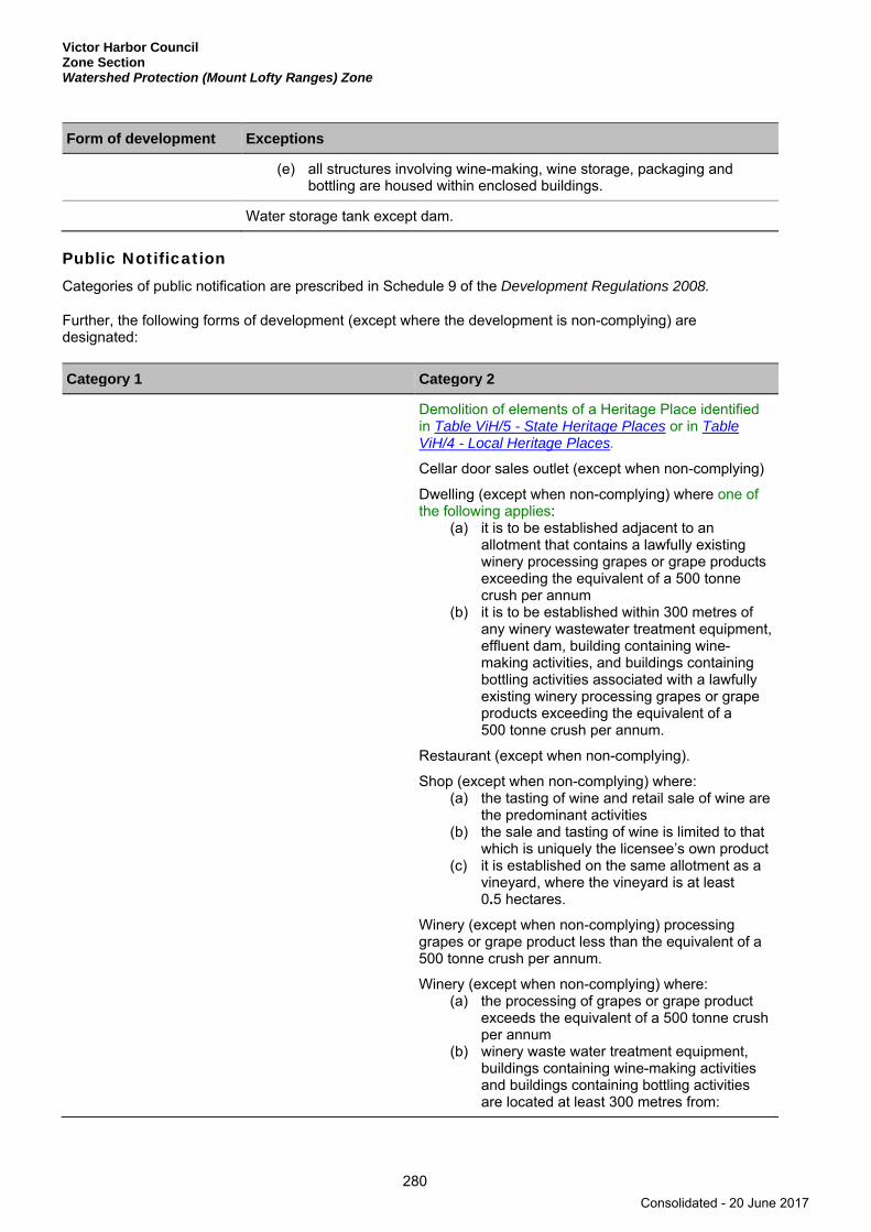
Victor Harbor Council Zone Section Watershed Protection (Mount Lofty Ranges) Zone
280
Form of development Exceptions
(e) all structures involving wine-making, wine storage, packaging and bottling are housed within enclosed buildings.
Water storage tank except dam.
Public Notification Categories of public notification are prescribed in Schedule 9 of the Development Regulations 2008.
Further, the following forms of development (except where the development is non-complying) are designated:
Category 1 Category 2
Demolition of elements of a Heritage Place identified in Table ViH/5 - State Heritage Places or in Table ViH/4 - Local Heritage Places.
Cellar door sales outlet (except when non-complying)
Dwelling (except when non-complying) where one of the following applies:
(a) it is to be established adjacent to an allotment that contains a lawfully existing winery processing grapes or grape products exceeding the equivalent of a 500 tonne crush per annum
(b) it is to be established within 300 metres of any winery wastewater treatment equipment, effluent dam, building containing wine-making activities, and buildings containing bottling activities associated with a lawfully existing winery processing grapes or grape products exceeding the equivalent of a 500 tonne crush per annum.
Restaurant (except when non-complying).
Shop (except when non-complying) where: (a) the tasting of wine and retail sale of wine are
the predominant activities (b) the sale and tasting of wine is limited to that
which is uniquely the licensee’s own product (c) it is established on the same allotment as a
vineyard, where the vineyard is at least 0.5 hectares.
Winery (except when non-complying) processing grapes or grape product less than the equivalent of a 500 tonne crush per annum.
Winery (except when non-complying) where: (a) the processing of grapes or grape product
exceeds the equivalent of a 500 tonne crush per annum
(b) winery waste water treatment equipment, buildings containing wine-making activities and buildings containing bottling activities are located at least 300 metres from:
Consolidated - 20 June 2017
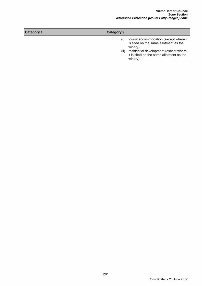
Victor Harbor Council Zone Section
Watershed Protection (Mount Lofty Ranges) Zone
281
Category 1 Category 2
(i) tourist accommodation (except where it is sited on the same allotment as the winery)
(ii) residential development (except where it is sited on the same allotment as the winery).
Consolidated - 20 June 2017

Consolidated - 20 June 2017

Victor Harbor Council Table Section
283
Table Section
Consolidated - 20 June 2017

Consolidated - 20 June 2017
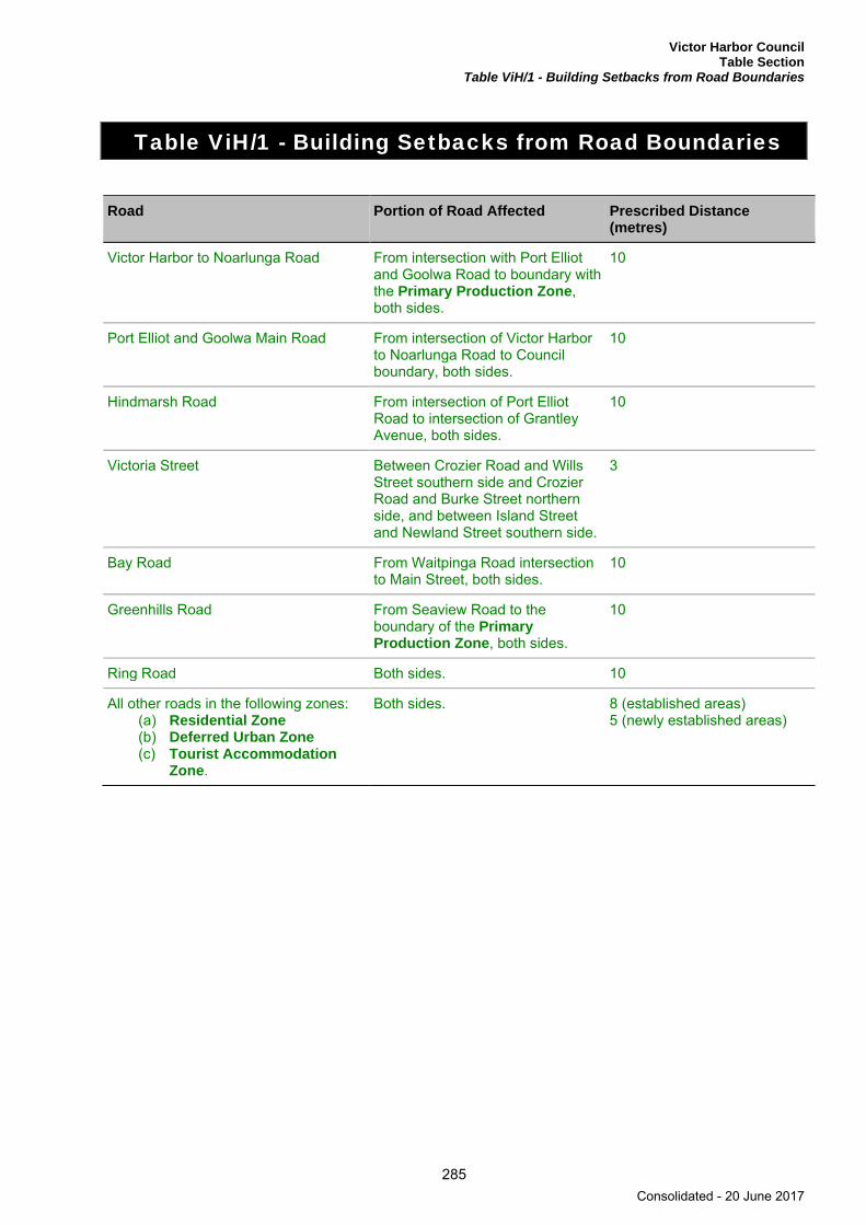
Victor Harbor Council Table Section
Table ViH/1 - Building Setbacks from Road Boundaries
285
Table ViH/1 - Building Setbacks from Road Boundaries
Road Portion of Road Affected Prescribed Distance (metres)
Victor Harbor to Noarlunga Road From intersection with Port Elliot and Goolwa Road to boundary with the Primary Production Zone, both sides.
10
Port Elliot and Goolwa Main Road From intersection of Victor Harbor to Noarlunga Road to Council boundary, both sides.
10
Hindmarsh Road From intersection of Port Elliot Road to intersection of Grantley Avenue, both sides.
10
Victoria Street Between Crozier Road and Wills Street southern side and Crozier Road and Burke Street northern side, and between Island Street and Newland Street southern side.
3
Bay Road From Waitpinga Road intersection to Main Street, both sides.
10
Greenhills Road From Seaview Road to the boundary of the Primary Production Zone, both sides.
10
Ring Road Both sides. 10
All other roads in the following zones: (a) Residential Zone (b) Deferred Urban Zone (c) Tourist Accommodation
Zone.
Both sides. 8 (established areas) 5 (newly established areas)
Consolidated - 20 June 2017
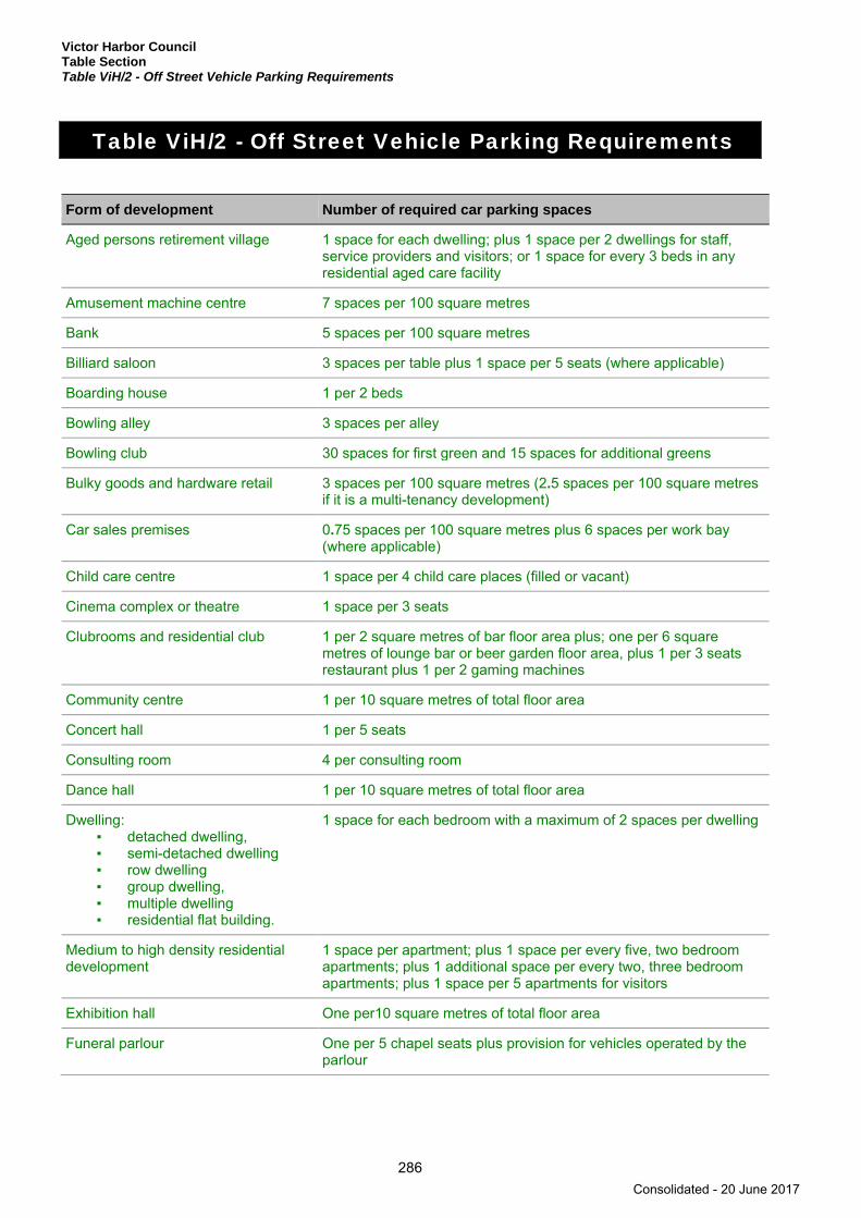
Victor Harbor Council Table Section Table ViH/2 - Off Street Vehicle Parking Requirements
286
Table ViH/2 - Off Street Vehicle Parking Requirements
Form of development Number of required car parking spaces
Aged persons retirement village 1 space for each dwelling; plus 1 space per 2 dwellings for staff, service providers and visitors; or 1 space for every 3 beds in any residential aged care facility
Amusement machine centre 7 spaces per 100 square metres
Bank 5 spaces per 100 square metres
Billiard saloon 3 spaces per table plus 1 space per 5 seats (where applicable)
Boarding house 1 per 2 beds
Bowling alley 3 spaces per alley
Bowling club 30 spaces for first green and 15 spaces for additional greens
Bulky goods and hardware retail 3 spaces per 100 square metres (2.5 spaces per 100 square metresif it is a multi-tenancy development)
Car sales premises 0.75 spaces per 100 square metres plus 6 spaces per work bay (where applicable)
Child care centre 1 space per 4 child care places (filled or vacant)
Cinema complex or theatre 1 space per 3 seats
Clubrooms and residential club 1 per 2 square metres of bar floor area plus; one per 6 square metres of lounge bar or beer garden floor area, plus 1 per 3 seats restaurant plus 1 per 2 gaming machines
Community centre 1 per 10 square metres of total floor area
Concert hall 1 per 5 seats
Consulting room 4 per consulting room
Dance hall 1 per 10 square metres of total floor area
Dwelling: ▪ detached dwelling,▪ semi-detached dwelling▪ row dwelling▪ group dwelling,▪ multiple dwelling▪ residential flat building.
1 space for each bedroom with a maximum of 2 spaces per dwelling
Medium to high density residential development
1 space per apartment; plus 1 space per every five, two bedroom apartments; plus 1 additional space per every two, three bedroom apartments; plus 1 space per 5 apartments for visitors
Exhibition hall One per10 square metres of total floor area
Funeral parlour One per 5 chapel seats plus provision for vehicles operated by the parlour
Consolidated - 20 June 2017
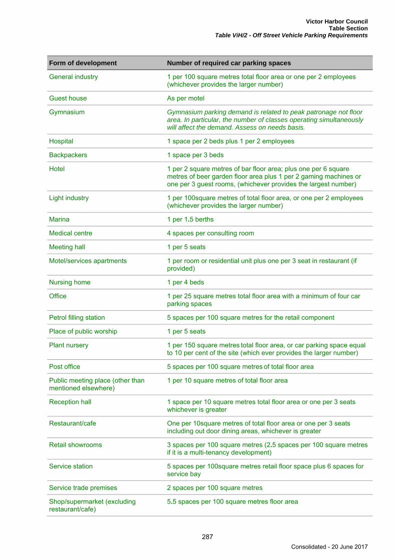
Victor Harbor Council Table Section
Table ViH/2 - Off Street Vehicle Parking Requirements
287
Form of development Number of required car parking spaces
General industry 1 per 100 square metres total floor area or one per 2 employees (whichever provides the larger number)
Guest house As per motel
Gymnasium Gymnasium parking demand is related to peak patronage not floor area. In particular, the number of classes operating simultaneously will affect the demand. Assess on needs basis.
Hospital 1 space per 2 beds plus 1 per 2 employees
Backpackers 1 space per 3 beds
Hotel 1 per 2 square metres of bar floor area; plus one per 6 square metres of beer garden floor area plus 1 per 2 gaming machines or one per 3 guest rooms, (whichever provides the largest number)
Light industry 1 per 100square metres of total floor area, or one per 2 employees (whichever provides the larger number)
Marina 1 per 1.5 berths
Medical centre 4 spaces per consulting room
Meeting hall 1 per 5 seats
Motel/services apartments 1 per room or residential unit plus one per 3 seat in restaurant (if provided)
Nursing home 1 per 4 beds
Office 1 per 25 square metres total floor area with a minimum of four car parking spaces
Petrol filling station 5 spaces per 100 square metres for the retail component
Place of public worship 1 per 5 seats
Plant nursery 1 per 150 square metres total floor area, or car parking space equal to 10 per cent of the site (which ever provides the larger number)
Post office 5 spaces per 100 square metres of total floor area
Public meeting place (other than mentioned elsewhere)
1 per 10 square metres of total floor area
Reception hall 1 space per 10 square metres total floor area or one per 3 seats whichever is greater
Restaurant/cafe One per 10square metres of total floor area or one per 3 seats including out door dining areas, whichever is greater
Retail showrooms 3 spaces per 100 square metres (2.5 spaces per 100 square metres
if it is a multi-tenancy development)
Service station 5 spaces per 100square metres retail floor space plus 6 spaces for service bay
Service trade premises 2 spaces per 100 square metres
Shop/supermarket (excluding restaurant/cafe)
5.5 spaces per 100 square metres floor area
Consolidated - 20 June 2017
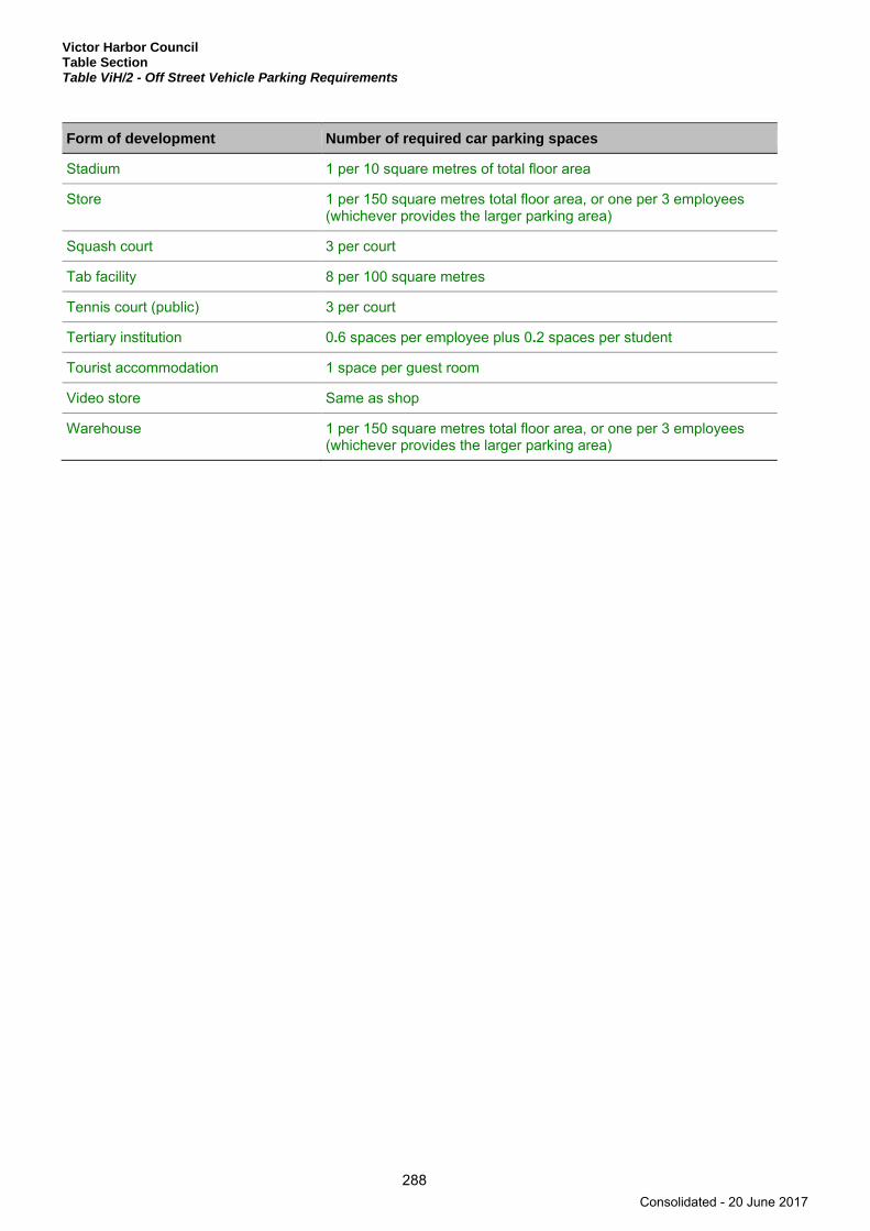
Victor Harbor Council Table Section Table ViH/2 - Off Street Vehicle Parking Requirements
288
Form of development Number of required car parking spaces
Stadium 1 per 10 square metres of total floor area
Store 1 per 150 square metres total floor area, or one per 3 employees (whichever provides the larger parking area)
Squash court 3 per court
Tab facility 8 per 100 square metres
Tennis court (public) 3 per court
Tertiary institution 0.6 spaces per employee plus 0.2 spaces per student
Tourist accommodation 1 space per guest room
Video store Same as shop
Warehouse 1 per 150 square metres total floor area, or one per 3 employees (whichever provides the larger parking area)
Consolidated - 20 June 2017
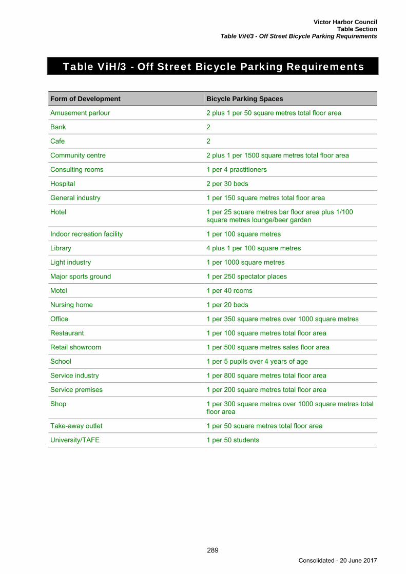
Victor Harbor Council Table Section
Table ViH/3 - Off Street Bicycle Parking Requirements
289
Table ViH/3 - Off Street Bicycle Parking Requirements
Form of Development Bicycle Parking Spaces
Amusement parlour 2 plus 1 per 50 square metres total floor area
Bank 2
Cafe 2
Community centre 2 plus 1 per 1500 square metres total floor area
Consulting rooms 1 per 4 practitioners
Hospital 2 per 30 beds
General industry 1 per 150 square metres total floor area
Hotel 1 per 25 square metres bar floor area plus 1/100 square metres lounge/beer garden
Indoor recreation facility 1 per 100 square metres
Library 4 plus 1 per 100 square metres
Light industry 1 per 1000 square metres
Major sports ground 1 per 250 spectator places
Motel 1 per 40 rooms
Nursing home 1 per 20 beds
Office 1 per 350 square metres over 1000 square metres
Restaurant 1 per 100 square metres total floor area
Retail showroom 1 per 500 square metres sales floor area
School 1 per 5 pupils over 4 years of age
Service industry 1 per 800 square metres total floor area
Service premises 1 per 200 square metres total floor area
Shop 1 per 300 square metres over 1000 square metres total floor area
Take-away outlet 1 per 50 square metres total floor area
University/TAFE 1 per 50 students
Consolidated - 20 June 2017

Victor Harbor Council Table Section Table ViH/4 - Local Heritage Places
290
Table ViH/4 - Local Heritage Places
Property Address Description and/or Extent of Listed Place
Lot No. or Part Sec
Plan No. Certificate of Title
Section 23(4) Criteria
Heritage NR
Lot 27 Hancock Road BACK VALLEY
Ruin-Former Congregational Church and Cemetery; All - Key features are existing form and environs.
A27 D73483 CT 6012/589 a c 14630
557 Inman Valley Road Road BACK VALLEY
Lower Inman Memorial Hall; All - Key features are existing form and scale with original features of corrugated iron walls, timber-framed doors and windows, and corrugated iron roof.
A113 F166172 CT 5824/474 a b c 14632
Lot 100 Wilson Hill Road BACK VALLEY
Former Military Camp Site; Key feature is retention of some of the original site and evidence of early use.
A100 D93527 CT 6143/143 a 14656
1-3 Battye Road ENCOUNTER BAY
Battye Farm Homestead building and long-barn outbuilding previously used as a milking shed and horse stables; Battye Farm Homestead Building and adjacent long outbuilding previously used as a milking shed and horse stables. Key features - existing form and scale with original features of bluestone, timber framed doors and windows, and corrugated iron roof.
A4 D79826 CT 6027/574 a e 14664
173 Bay Road ENCOUNTER BAY
Dwelling; All (excluding roofing material) - Key features are existing form and scale with original features of bluestone, red brick quoins, timber-framed doors and windows, hipped roof and a return veranda.
A74 D44545 CT 5333/150 e 14660
Consolidated - 20 June 2017
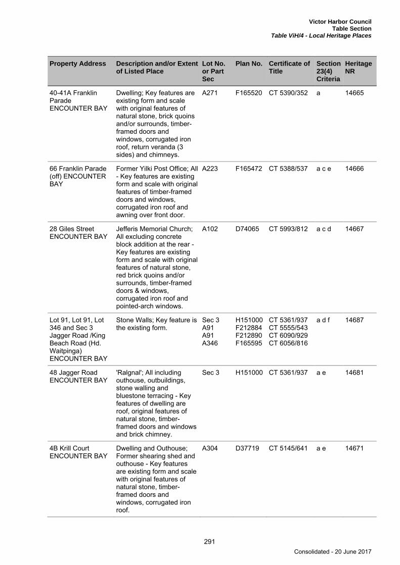
Victor Harbor Council Table Section
Table ViH/4 - Local Heritage Places
291
Property Address Description and/or Extent of Listed Place
Lot No. or Part Sec
Plan No. Certificate of Title
Section 23(4) Criteria
Heritage NR
40-41A Franklin Parade ENCOUNTER BAY
Dwelling; Key features are existing form and scale with original features of natural stone, brick quoins and/or surrounds, timber-framed doors and windows, corrugated iron roof, return veranda (3 sides) and chimneys.
A271 F165520 CT 5390/352 a 14665
66 Franklin Parade (off) ENCOUNTER BAY
Former Yilki Post Office; All - Key features are existing form and scale with original features of timber-framed doors and windows, corrugated iron roof and awning over front door.
A223 F165472 CT 5388/537 a c e 14666
28 Giles Street ENCOUNTER BAY
Jefferis Memorial Church; All excluding concrete block addition at the rear - Key features are existing form and scale with original features of natural stone, red brick quoins and/or surrounds, timber-framed doors & windows, corrugated iron roof and pointed-arch windows.
A102 D74065 CT 5993/812 a c d 14667
Lot 91, Lot 91, Lot 346 and Sec 3 Jagger Road /King Beach Road (Hd. Waitpinga) ENCOUNTER BAY
Stone Walls; Key feature is the existing form.
Sec 3 A91 A91 A346
H151000 F212884 F212890 F165595
CT 5361/937 CT 5555/543 CT 6090/929 CT 6056/816
a d f 14687
48 Jagger Road ENCOUNTER BAY
'Ralgnal'; All including outhouse, outbuildings, stone walling and bluestone terracing - Key features of dwelling are roof, original features of natural stone, timber-framed doors and windows and brick chimney.
Sec 3 H151000 CT 5361/937 a e 14681
4B Krill Court ENCOUNTER BAY
Dwelling and Outhouse; Former shearing shed and outhouse - Key features are existing form and scale with original features of natural stone, timber-framed doors and windows, corrugated iron roof.
A304 D37719 CT 5145/641 a e 14671
Consolidated - 20 June 2017

Victor Harbor Council Table Section Table ViH/4 - Local Heritage Places
292
Property Address Description and/or Extent of Listed Place
Lot No. or Part Sec
Plan No. Certificate of Title
Section 23(4) Criteria
Heritage NR
3 - 7 Mill Road ENCOUNTER BAY
Former Butter Factory; Cottage and attached shop - Key features are existing form and scale with original features of natural stone, timber-framed doors and windows, corrugated iron roof and a veranda.
A501 D46450 CT 5404/880 a e 14672
9 Russell Street ENCOUNTER BAY
Dwelling - 'Maryville'; All including underground water tank with ground level brick done - Key features are existing form and scale with original features of natural stone, red brick quoins and/or surrounds, timber-framed doors and windows, corrugated iron roof and front veranda.
A506 F46100 CT 5936/256 e 14674
Lot 275 Tabernacle Road ENCOUNTER BAY
'Yilki Farm'; All including limestone/timber outbuildings and machine shed - Key features are existing form and scale with original features of natural stone, red brick quoins and/or surrounds, timber-framed doors and windows, return veranda & chimneys.
A275 F165524 CT 5406/937 a e 14677
Lot 91 Tabernacle Road ENCOUNTER BAY
Tabernacle Cemetery/ Newland Memorial Gates; All - Key features are existing form and environs.
A91 A179
F162862 D71731
CT 5307/787 CT 5980/810
a c e 14678
836 Hindmarsh Tiers Road HINDMARSH TIERS
Slab Cottage; All (excluding modern addition to rear) and associated outhouses and outbuildings - Key features are existing form and scale with original features of timber walls, timber-framed doors and windows, corrugated iron twin hipped roof, a veranda and chimneys.
Sec 104 H150300 CT 5395/559 a d 14684
1446 Hindmarsh Tiers Road HINDMARSH TIERS
Former Mt Jagged Mine; Key feature is retention of some of the original site and evidence of early use.
A14 A51
D67349 D75808
CT 5943/44 CT 6000/100
a 14683
Consolidated - 20 June 2017

Victor Harbor Council Table Section
Table ViH/4 - Local Heritage Places
293
Property Address Description and/or Extent of Listed Place
Lot No. or Part Sec
Plan No. Certificate of Title
Section 23(4) Criteria
Heritage NR
30 Hindmarsh Tiers Road HINDMARSH VALLEY
Hall; Key features are existing form and scale, porch and stone feature topped by small flagpole.
A1 F9097 CT 5824/439 a b c 14637
31 Hindmarsh Tiers Road HINDMARSH VALLEY
Former School; All - Key features are existing form and scale with original features of natural stone and corrugated iron gabled roof.
A175 F165424 CT 5820/363 a c 14638
925 Hindmarsh Tiers Road HINDMARSH VALLEY
Former Smelter Site; Key feature is retention of some of the original site and evidence of early use.
A4 D68884 CT 5954/738 a 14685
961 Hindmarsh Tiers Road HINDMARSH VALLEY
Cottage; Key features are existing form and scale with original features of natural stone, timber-framed doors and windows, corrugated iron roof and a veranda.
A130 F165379 CT 5805/492 a e 14686
15 Lincoln Park Drive (off) HINDMARSH VALLEY
'Lincoln Park'; All including bluestone and brick outbuildings and underground tank (excluding modern dairy). Key features are existing form and scale with original features of natural stone, red brick quoins and/or surrounds, timber-framed doors and windows, corrugated iron roof, veranda and balcony, and cast iron decoration.
Q405 & Q406
D72316 CT 6054/974 a d e 14653
40 Nangawooka Track HINDMARSH VALLEY
'Nangawooka'; All including outbuildings - Key features are existing form and scale with original features of natural stone, red brick quoins and/or surrounds, timber-framed doors and windows, corrugated iron roof.
A12 D50364 CT 6054/976 a d e 14652
Consolidated - 20 June 2017
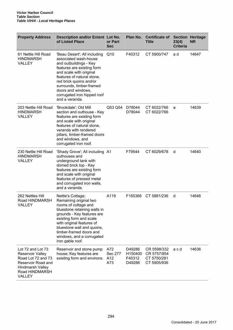
Victor Harbor Council Table Section Table ViH/4 - Local Heritage Places
294
Property Address Description and/or Extent of Listed Place
Lot No. or Part Sec
Plan No. Certificate of Title
Section 23(4) Criteria
Heritage NR
61 Nettle Hill Road HINDMARSH VALLEY
'Beau Desert'; All including associated wash-house and outbuildings - Key features are existing form and scale with original features of natural stone, red brick quoins and/or surrounds, timber-framed doors and windows, corrugated iron hipped roof and a veranda.
Q10 F40312 CT 5900/747 a d 14647
203 Nettle Hill Road HINDMARSH VALLEY
'Brookdale'; Old Mill section and outhouse - Key features are existing form and scale with original features of natural stone, veranda with rendered pillars, timber-framed doors and windows, and corrugated iron roof.
Q53 Q54 D78044 D78044
CT 6022/766 CT 6022/766
a 14639
230 Nettle Hill Road HINDMARSH VALLEY
'Shady Grove'; All including outhouses and underground tank with domed brick top - Key features are existing form and scale with original features of pressed metal and corrugated iron walls, and a veranda.
A1 F79544 CT 6029/678 d 14640
262 Nettles Hill Road HINDMARSH VALLEY
Nettle's Cottage; Remaining original two rooms of cottage and bluestone retaining walls in grounds - Key features are existing form and scale with original features of bluestone wall and quoins, timber-framed doors and windows, and a corrugated iron gable roof.
A119 F165368 CT 5881/236 d 14646
Lot 72 and Lot 73 Reservoir Valley Road Lot 72 and 73 Reservoir Road and Hindmarsh Valley Road HINDMARSH VALLEY
Reservoir and stone pump house; Key features are existing form and environs.
A72 Sec 277 A12 A73
D49286 H150400 F40312 D49286
CR 5598/332 CR 5757/854 CT 5750/281 CT 5905/936
a c d 14636
Consolidated - 20 June 2017
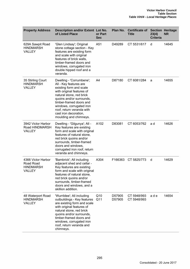
Victor Harbor Council Table Section
Table ViH/4 - Local Heritage Places
295
Property Address Description and/or Extent of Listed Place
Lot No. or Part Sec
Plan No. Certificate of Title
Section 23(4) Criteria
Heritage NR
629A Sawpit Road HINDMARSH VALLEY
'Glen Lindsay'; Original stone cottage section - Key features are existing form and scale with original features of brick walls, timber-framed doors and windows, corrugated iron double hipped roof and a veranda.
A51 D49289 CT 5531/617 d 14645
35 Stirling Court HINDMARSH VALLEY
Dwelling - 'Corrumbene'; All - Key features are existing form and scale with original features of natural stone, red brick quoins and/or surrounds, timber-framed doors and windows, corrugated iron roof, return veranda with cast iron decoration, moulding and chimneys.
A4 D87180 CT 6081/284 a 14655
3942 Victor Harbor Road HINDMARSH VALLEY
Dwelling - 'Gilgunya'; All - Key features are existing form and scale with original features of natural stone, red brick quoins and/or surrounds, timber-framed doors and windows, corrugated iron roof, return veranda and chimneys.
A102 D83081 CT 6053/762 a d 14626
4366 Victor Harbor Road Road HINDMARSH VALLEY
'Bambrick'; All including adjacent shed and cellar - Key features are existing form and scale with original features of natural stone, red brick quoins and/or surrounds, timber-framed doors and windows, and a skillion addition.
A304 F166363 CT 5825/773 d 14629
48 Waterport Road HINDMARSH VALLEY
'Wurrildee'; All including outbuildings - Key features are existing form and scale with original features of natural stone, red brick quoins and/or surrounds, timber-framed doors and windows, corrugated iron roof, return veranda and chimneys.
Q10 Q11
D57905 D57905
CT 5948/993 CT 5948/993
a d e 14654
Consolidated - 20 June 2017

Victor Harbor Council Table Section Table ViH/4 - Local Heritage Places
296
Property Address Description and/or Extent of Listed Place
Lot No. or Part Sec
Plan No. Certificate of Title
Section 23(4) Criteria
Heritage NR
296 Alma Road INMAN VALLEY
Dwelling - 'Avalon'; All - Key features are existing form and scale with original features of natural stone, timber-framed doors and windows, corrugated iron roof and return veranda.
A43 D51677 CT 5736/878 a 14634
296 Mt Alma Road INMAN VALLEY
'Mt Alma' Homestead; All including two large garages and shearing shed - Key features are existing form and scale with original features of natural stone, timber-framed doors and windows, and corrugated iron roof.
A43 D51677 CT 5736/878 a d 14635
33 Parsons Road INMAN VALLEY
Dwelling; All including ironstone garage - Key features are existing form and scale with original features of natural stone, timber-framed doors and windows, corrugated iron roof, return veranda and Bungalow feature of low pitched wide gables.
A50 D84824 CT 6065/86 a d e 14642
93 Prouse Road INMAN VALLEY
Cemetery; Key features are existing form and bushland environs.
Sec 768 H150300 CT 43/46 a c 14643
Lot 12 Inman Valley Road LOWER INMAN VALLEY
Middle Inman School; All - Key features are existing form and scale with original features of natural stone, red brick quoins and/or surrounds, timber-framed doors and windows, and corrugated iron roof.
A12 D29904 CT 5279/738 a c 14657
867 Inman Valley Road LOWER INMAN VALLEY
Lower Inman Congregational Church; All - Key features are existing form and scale with original features of natural stone, red brick quoins and/or surrounds, timber-framed doors and windows, and corrugated iron roof.
A12 D29904 CT 5279/738 a c 14631
Hindmarsh Road MCCRACKEN
New Alexandra Bridge; All - Key features are existing form with original features of concrete and iron balustrading.
RR a 14669
Consolidated - 20 June 2017

Victor Harbor Council Table Section
Table ViH/4 - Local Heritage Places
297
Property Address Description and/or Extent of Listed Place
Lot No. or Part Sec
Plan No. Certificate of Title
Section 23(4) Criteria
Heritage NR
corner Albert Place and Crozier Road VICTOR HARBOR
Norfolk Island Pine Tree; All.
RR a 14594
23-25 Albert Place VICTOR HARBOR
Shop; Key features are existing form and scale with original features of natural stone, red brick quoins and/or surrounds, timber-framed doors and windows, corrugated iron roof, a veranda and balcony.
A102 A103
F166411 F166411
CT 5311/789 CT 5311/789
a c 14593
Section 776 Bridge Terrace VICTOR HARBOR
Tennis Clubhouse; All - Key features are existing form and scale with original features of red brick walls, timber-framed doors and windows, and tiled roof.
Sec 776 H150300 CR 5756/546 a c d 14624
18-24 Burke Street VICTOR HARBOR
St Augustine's Church Hall; All - Key features are existing form and scale with original features of natural stone, red brick quoins and/or surrounds, timber-framed doors and windows, corrugated iron roof and pointed-arch windows and doors.
A300 D24602 CT 5415/740 a b 14661
Coral Street VICTOR HARBOR
Palm Tree; All. RR a 14595
13 Coral Street VICTOR HARBOR
Newspaper Office; Front building only - Key features are existing form and scale with original features of local limestone with red brick quoins (now painted), two projecting gabled bays of unequal width trimmed with finials and a hipped corrugated iron roof. The central veranda is a reconstruction of the original.
A562 F165811 CT 5679/919 a c 14596
Consolidated - 20 June 2017
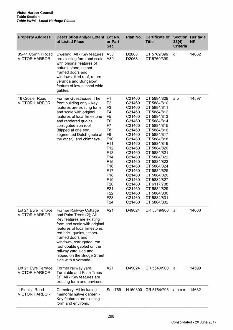
Victor Harbor Council Table Section Table ViH/4 - Local Heritage Places
298
Property Address Description and/or Extent of Listed Place
Lot No. or Part Sec
Plan No. Certificate of Title
Section 23(4) Criteria
Heritage NR
35-41 Cornhill Road VICTOR HARBOR
Dwelling; All - Key features are existing form and scale with original features of natural stone, timber-framed doors and windows, tiled roof, return veranda and Bungalow feature of low-pitched wide gables.
A38 A39
D2068 D2068
CT 5769/399 CT 5769/399
d 14662
16 Crozier Road VICTOR HARBOR
Former Guesthouse; The front building only - Key features are existing form and scale with original features of local limestone and rendered quoins, corrugated iron roof (hipped at one end, segmented Dutch gable at the other), and chimneys.
F1 F2 F3 F4 F5 F6 F7 F8 F9 F10 F11 F12 F13 F14 F15 F16 F17 F18 F19 F20 F21 F22 F23 F24
C21460 C21460 C21460 C21460 C21460 C21460 C21460 C21460 C21460 C21460 C21460 C21460 C21460 C21460 C21460 C21460 C21460 C21460 C21460 C21460 C21460 C21460 C21460 C21460
CT 5884/809 CT 5884/810 CT 5884/811 CT 5884/812 CT 5884/813 CT 5884/814 CT 5884/815 CT 5884/816 CT 5884/817 CT 5884/818 CT 5884/819 CT 5884/820 CT 5884/821 CT 5884/822 CT 5884/823 CT 5884/824 CT 5884/825 CT 5884/826 CT 5884/827 CT 6117/738 CT 5884/829 CT 5884/830 CT 5884/831 CT 5884/832
a b 14597
Lot 21 Eyre Terrace VICTOR HARBOR
Former Railway Cottage and Palm Trees (2); All - Key features are existing form and scale with original features of local limestone, red brick quoins, timber-framed doors and windows, corrugated iron roof double gabled on the railway yard side and hipped on the Bridge Street side with a veranda.
A21 D49024 CR 5549/900 a 14600
Lot 21 Eyre Terrace VICTOR HARBOR
Former railway yard, Turntable and Palm Trees (3); All - Key features are existing form and environs.
A21 D49024 CR 5549/900 a 14599
1 Finniss Road VICTOR HARBOR
Cemetery; All including memorial native garden - Key features are existing form and environs.
Sec 769 H150300 CR 5764/795 a b c e 14682
Consolidated - 20 June 2017

Victor Harbor Council Table Section
Table ViH/4 - Local Heritage Places
299
Property Address Description and/or Extent of Listed Place
Lot No. or Part Sec
Plan No. Certificate of Title
Section 23(4) Criteria
Heritage NR
20-23 Flinders Parade VICTOR HARBOR
Norfolk Island Pine Tree; All.
RR a 14603
3 George Main Road VICTOR HARBOR
High School (older section); Older single storey section - Key features are existing form and scale with original features of red brick walls, timber-framed doors and windows, corrugated iron roof, tower and central three-light window.
A11 D14245 CT 5659/352 a c 14659
3 George Main Road VICTOR HARBOR
Newland Bridge; All - Key features are existing form with concrete and iron balustrading.
RR a 14668
155 Hindmarsh Road VICTOR HARBOR
Dwelling and attached shop; All - Key features are existing form and scale with original features of natural stone, red brick quoins and/or surrounds, timber-framed doors and windows, tiled roof, return veranda and Bungalow feature of low-pitched wide gables.
A88 D2385 CT 5589/416 a c 14604
158 Hindmarsh Road VICTOR HARBOR
Masonic Lodge (Lodge of Peace No. 99); All - Key features include the original internal ceilings and the building’s existing form and scale with original features of sandstone front and side walls set on plinth of rusticated sandstone, timber-framed doors and windows, corrugated iron roof, decorative render, portico and arrangement of windows to Hindmarsh Road.
A185 F166244 CT 5898/402 a c d 14605
Consolidated - 20 June 2017
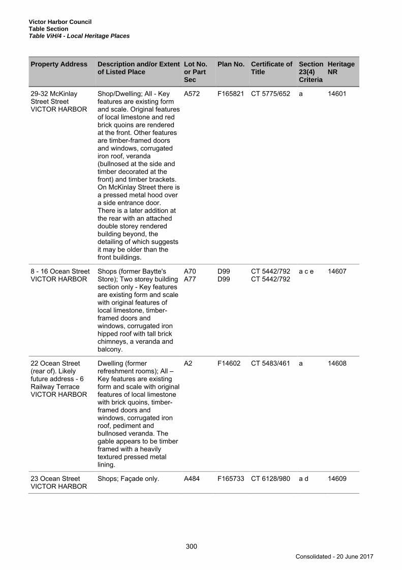
Victor Harbor Council Table Section Table ViH/4 - Local Heritage Places
300
Property Address Description and/or Extent of Listed Place
Lot No. or Part Sec
Plan No. Certificate of Title
Section 23(4) Criteria
Heritage NR
29-32 McKinlay Street Street VICTOR HARBOR
Shop/Dwelling; All - Key features are existing form and scale. Original features of local limestone and red brick quoins are rendered at the front. Other features are timber-framed doors and windows, corrugated iron roof, veranda (bullnosed at the side and timber decorated at the front) and timber brackets. On McKinlay Street there is a pressed metal hood over a side entrance door. There is a later addition at the rear with an attached double storey rendered building beyond, the detailing of which suggests it may be older than the front buildings.
A572 F165821 CT 5775/652 a 14601
8 - 16 Ocean Street VICTOR HARBOR
Shops (former Baytte's Store); Two storey building section only - Key features are existing form and scale with original features of local limestone, timber-framed doors and windows, corrugated iron hipped roof with tall brick chimneys, a veranda and balcony.
A70 A77
D99 D99
CT 5442/792 CT 5442/792
a c e 14607
22 Ocean Street (rear of). Likely future address - 6 Railway Terrace VICTOR HARBOR
Dwelling (former refreshment rooms); All – Key features are existing form and scale with original features of local limestone with brick quoins, timber-framed doors and windows, corrugated iron roof, pediment and bullnosed veranda. The gable appears to be timber framed with a heavily textured pressed metal lining.
A2 F14602 CT 5483/461 a 14608
23 Ocean Street VICTOR HARBOR
Shops; Façade only. A484 F165733 CT 6128/980 a d 14609
Consolidated - 20 June 2017

Victor Harbor Council Table Section
Table ViH/4 - Local Heritage Places
301
Property Address Description and/or Extent of Listed Place
Lot No. or Part Sec
Plan No. Certificate of Title
Section 23(4) Criteria
Heritage NR
24 Ocean Street VICTOR HARBOR
Shops; All - Key features are existing form and scale with original features of local limestone and brick quoins (part painted), first floor Art Moderne balcony and veranda and large display window to one side.
A2 D87407 CT 6088/897 a e 14610
26 Ocean Street VICTOR HARBOR
Former Commercial Bank; All - Key features are existing form and scale with original features of decorative render, moulded features, masonry balcony and cast iron decoration (veranda not original).
A1 D87407 CT 6088/896 a c d 14611
35 Ocean Street VICTOR HARBOR
Shops (former Coffee Palace); Central two storey building section only - Key features are existing form and scale with original features of pediment, first floor balcony with cast iron panels to balustrade, and a veranda.
A87 D99 CT 6133/965 a b 14612
37-41 Ocean Street VICTOR HARBOR
Victa Cinema; All - Key features are existing form and scale of Art Deco with original building features of decorative render, main glass doors and shop-fronts, vertical sign and veranda.
A94 A86
F165303 D99
CT 5309/930 CT 5309/931
a c d 14613
43 Ocean Street /Corner Coral Street VICTOR HARBOR
Bells Store; All - Key features are existing form and scale with original features of rendered pediment and walls, and window positions at first floor level. Single storey sections are either side of the two storey corner building (note veranda is not the original).
A85 D99 CT 5084/392 a c e f 14614
Consolidated - 20 June 2017
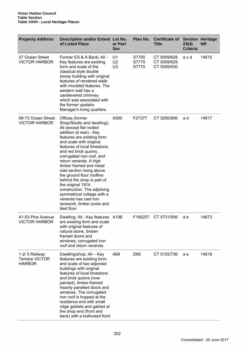
Victor Harbor Council Table Section Table ViH/4 - Local Heritage Places
302
Property Address Description and/or Extent of Listed Place
Lot No. or Part Sec
Plan No. Certificate of Title
Section 23(4) Criteria
Heritage NR
57 Ocean Street VICTOR HARBOR
Former ES & A Bank; All - Key features are existing form and scale of the classical style double storey building with original features of rendered walls with moulded features. The western wall has a cantilevered chimney which was associated with the former upstairs Manager's living quarters.
U1 U2 U3
S7700 S7770 S7770
CT 5009/628 CT 5009/629 CT 5009/630
a c d 14615
69-73 Ocean Street VICTOR HARBOR
Offices (former Shop/Studio and dwelling); All (except flat roofed addition at rear) - Key features are existing form and scale with original features of local limestone and red brick quoins, corrugated iron roof, and return veranda. A high timber framed and metal clad section rising above the ground floor roofline behind the shop is part of the original 1914 construction. The adjoining symmetrical cottage with a veranda has cast iron lacework, timber posts and tiled floor.
A500 F27377 CT 5250/806 a d 14617
41-53 Pine Avenue VICTOR HARBOR
Dwelling; All - Key features are existing form and scale with original features of natural stone, timber-framed doors and windows, corrugated iron roof and return veranda.
A198 F166257 CT 5731/556 d e 14673
1-2/ 5 Railway Terrace VICTOR HARBOR
Dwelling/shop; All – Key features are existing form and scale of two adjoined buildings with original features of local limestone and brick quoins (now painted), timber-framed heavily panelled doors and windows. The corrugated iron roof is hopped at the residence end with small ridge gablets and gabled at the shop end (front and back) with a bullnosed front
A69 D66 CT 5105/736 a e 14618
Consolidated - 20 June 2017

Victor Harbor Council Table Section
Table ViH/4 - Local Heritage Places
303
Property Address Description and/or Extent of Listed Place
Lot No. or Part Sec
Plan No. Certificate of Title
Section 23(4) Criteria
Heritage NR
veranda with stop chamfered timber posts extending the full width of the building.
7a Railway Terrace VICTOR HARBOR
Shop/Dwelling (former bakery and tea rooms); All – Key features are existing form and scale with original features of local limestone and red brick quoins, hipped corrugated iron roof, arched pediment, bullnose front veranda and chimneys. The shop/dwelling adjoins a gabled fronted building which has its own straight corrugated galvanised iron veranda at the front.
A3 D87407 CT 6116/185 a e 14619
30-32 Seaview Road VICTOR HARBOR
St Joan of Arc Church; Key features are existing form and scale of the rendered stylised Romanesque building with large porch to the front and attached bell tower to the rear, with other original features being small half-round leadlight windows, rose leadlight window on the main nave wall above the porch surrounded by ornamental brickwork, Marseilles tiled roof with brickwork around the gable.
A11 A12
D2068 D2068
CT 5358/135 CT 5837/211
a c d f 14675
51-55 Seaview Road VICTOR HARBOR
Dwelling; All - Key features are existing form and scale with original features of limestone, red brick quoins and/or surrounds, timber-framed doors and windows, corrugated iron roof, return veranda, cast iron balustrade to balcony, masonry steps.
A2 F102083 CT 5118/664 d e 14676
Consolidated - 20 June 2017
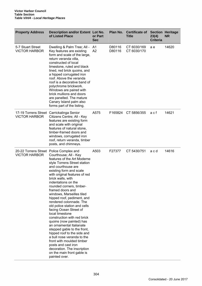
Victor Harbor Council Table Section Table ViH/4 - Local Heritage Places
304
Property Address Description and/or Extent of Listed Place
Lot No. or Part Sec
Plan No. Certificate of Title
Section 23(4) Criteria
Heritage NR
5-7 Stuart Street VICTOR HARBOR
Dwelling & Palm Tree; All - Key features are existing form and scale of the large, return veranda villa, constructed of local limestone, ruled and black lined, red brick quoins, and a hipped corrugated iron roof. Above the veranda roof is a decorative band of polychrome brickwork. Windows are paired with brick mullions and doors are panelled. The mature Canary Island palm also forms part of the listing.
A1 A2
D80116 D80116
CT 6030/169 CT 6030/170
a e 14620
17-19 Torrens Street VICTOR HARBOR
Carrickalinga Senior Citizens Centre; All - Key features are existing form and scale with original features of natural stone, timber-framed doors and windows, corrugated iron roof, return veranda, timber posts, and chimneys.
A575 F165824 CT 5856/355 a c f 14621
20-22 Torrens Street VICTOR HARBOR
Police Complex and Courthouse; All - Key features of the Art Moderne style Torrens Street station and courthouse are existing form and scale with original features of red brick walls, with indentations on the rounded corners, timber-framed doors and windows, Marseilles tiled hipped roof, pediment, and rendered colonnade. The old police station and cells facing Ocean Street of local limestone construction with red brick quoins (now painted) has an ornamental Italianate stepped gable to the front, hipped roof to the side and a bull nose veranda to the front with moulded timber posts and cast iron decoration. The inscription on the main front gable is painted over.
A503 F27377 CT 5430/751 a c d 14616
Consolidated - 20 June 2017

Victor Harbor Council Table Section
Table ViH/4 - Local Heritage Places
305
Property Address Description and/or Extent of Listed Place
Lot No. or Part Sec
Plan No. Certificate of Title
Section 23(4) Criteria
Heritage NR
21-37 Torrens Street VICTOR HARBOR
Former School; All - Key features are existing form and scale with original features of natural stone, red brick quoins and/or surrounds, corrugated iron roof and roof vents.
A6 D24412 CT 5199/70 a c 14622
Victoria Street VICTOR HARBOR
Row of Trees (3 pines, 2 palms); All.
RR a f 14623
Warland Reserve VICTOR HARBOR
Norfolk Island Pine Trees (8); All.
S757 H150300 CR 5756/545 a f 14625
17-19 Warne Street VICTOR HARBOR
Former Congregational Church; All - Key features are existing form and scale with original features of natural stone, red brick quoins and/or surrounds, timber-framed doors and windows, corrugated iron roof and pointed-arch window
A329 F165578 CT 5825/406 a c 14658
174 Coolawang Road WAITPINGA
Old Shearing Shed, 'Old Coolawang' complex; All including garage, stables and old shearing shed - Key features are existing form and scale with original features of natural stone, timber-framed doors and windows, and corrugated iron roof.
A1 S14
D49385 H151000
CT 5541/416 CT 5785/71
a b e 14628
Lot 1 Dennis Road Newland Conservation Park WAITPINGA
Dennis's Hut; All - Key features are existing form and scale with original features of natural stone, timber-framed doors and windows, corrugated iron roof and a chimney.
A10 D23229 CR 5778/27 a e 14680
76 Kings Beach Road WAITPINGA
King Cottage; Key features are existing form and scale with original features of natural stone walls, quoins and chimney, timber-framed doors and windows, corrugated iron gabled roof.
A61 D72974 CT 6009/937 a b e 14633
Consolidated - 20 June 2017

Victor Harbor Council Table Section Table ViH/4 - Local Heritage Places
306
Property Address Description and/or Extent of Listed Place
Lot No. or Part Sec
Plan No. Certificate of Title
Section 23(4) Criteria
Heritage NR
8 Mill Road WAITPINGA
Mill Cottage; All excluding besser block addition - Key features are existing form and scale with original features of ironstone, red brick quoins (stone quoins at front), timber-framed doors and windows, corrugated iron hipped roof and a veranda.
A92 A93
F166394 F166395
CT 5552/536 CT 5552/535
a e 14679
86 Parsons Beach Road WAITPINGA
'Nurunderi' Complex; All including outbuildings of various construction and farm infrastructure - Key features of main building are existing form and scale with original features of natural stone, timber-framed doors and windows, and corrugated iron roof.
S1324 A4
H151000 D80815
CT 5949/740 CT 5949/740
a 14641
Section 18 Pitkin Road WAITPINGA
Former RAAF Barrack Building; All - Key features are existing form and scale with original features of corrugated iron walls, timber-framed doors and windows, & corrugated iron roof.
Sec 18 H151000 CT 5597/742 a 14648
716 Waitpinga Road WAITPINGA
Dairy; All - Key features are existing form and scale.
A302 A304
F165021 F165021
CT 5859/604 CT 5859/525
a 14627
1161 Waitpinga Road WAITPINGA
Shearing Shed; All - Key features are existing form and scale with original features of natural stone, timber-framed doors and windows, and corrugated iron roof.
Q20 Q21 Q22
D89303 D89303 D89303
CT 6096/731 CT 6096/731 CT 6096/731
a d 14651
727 Waitpinga Road WAITPINGA
Dwelling - 'Santa Cruz'; All excluding cream brick addition - Key features are existing form and scale with original features of limestone, red brick quoins and/or surrounds, timber-framed doors and windows, corrugated iron roof, return veranda and Bungalow feature of low-pitched wide gables.
Sec 361 H151000 CT 5583/627 a b d 14650
Consolidated - 20 June 2017
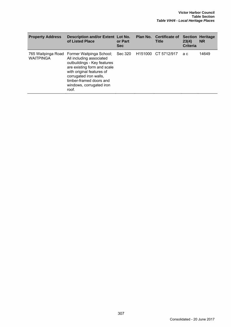
Victor Harbor Council Table Section
Table ViH/4 - Local Heritage Places
307
Property Address Description and/or Extent of Listed Place
Lot No. or Part Sec
Plan No. Certificate of Title
Section 23(4) Criteria
Heritage NR
765 Waitpinga Road WAITPINGA
Former Waitpinga School; All including associated outbuildings - Key features are existing form and scale with original features of corrugated iron walls, timber-framed doors and windows, corrugated iron roof.
Sec 320 H151000 CT 5712/917 a c 14649
Consolidated - 20 June 2017
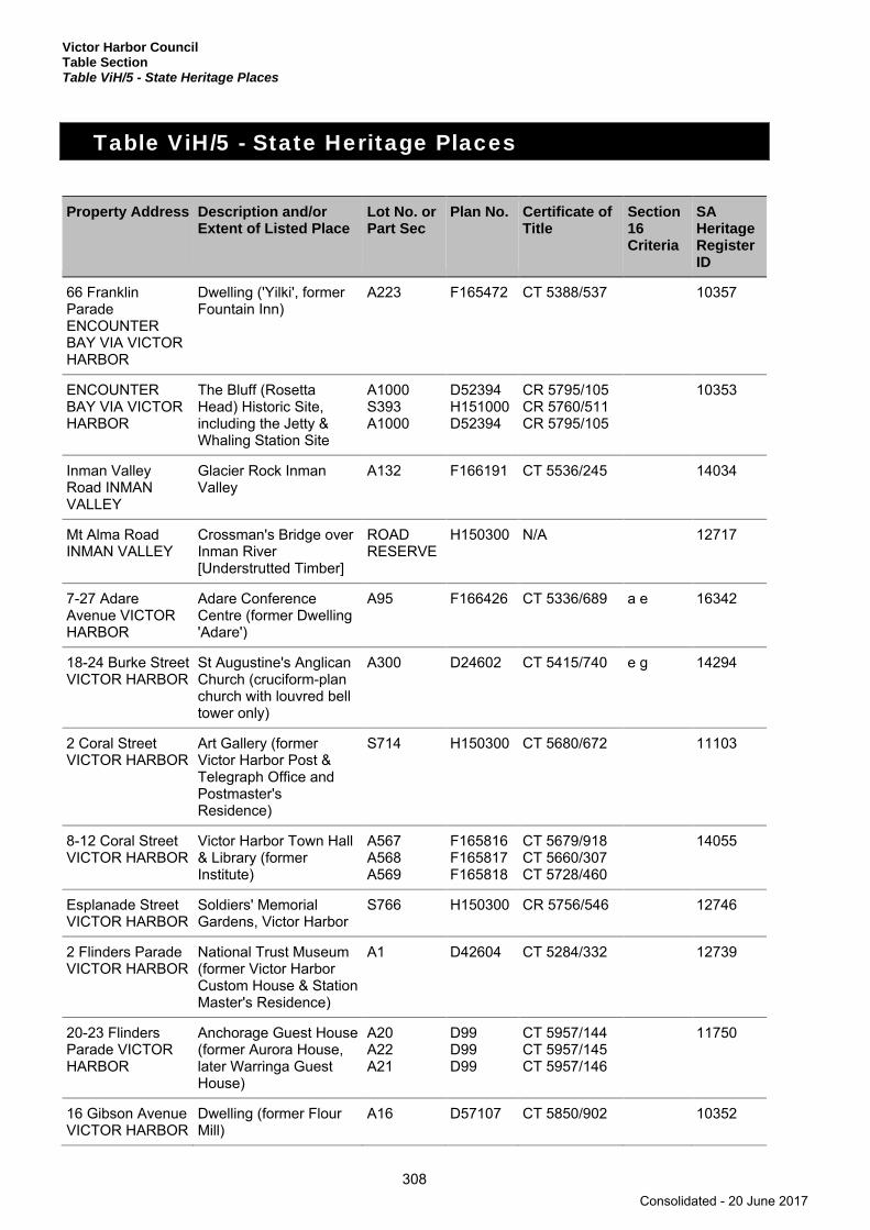
Victor Harbor Council Table Section Table ViH/5 - State Heritage Places
308
Table ViH/5 - State Heritage Places
Property Address Description and/or Extent of Listed Place
Lot No. or Part Sec
Plan No. Certificate of Title
Section 16 Criteria
SA Heritage Register ID
66 Franklin Parade ENCOUNTER BAY VIA VICTOR HARBOR
Dwelling ('Yilki', former Fountain Inn)
A223 F165472 CT 5388/537 10357
ENCOUNTER BAY VIA VICTOR HARBOR
The Bluff (Rosetta Head) Historic Site, including the Jetty & Whaling Station Site
A1000 S393 A1000
D52394 H151000 D52394
CR 5795/105 CR 5760/511 CR 5795/105
10353
Inman Valley Road INMAN VALLEY
Glacier Rock Inman Valley
A132 F166191 CT 5536/245 14034
Mt Alma Road INMAN VALLEY
Crossman's Bridge over Inman River [Understrutted Timber]
ROAD RESERVE
H150300 N/A 12717
7-27 Adare Avenue VICTOR HARBOR
Adare Conference Centre (former Dwelling 'Adare')
A95 F166426 CT 5336/689 a e 16342
18-24 Burke Street VICTOR HARBOR
St Augustine's Anglican Church (cruciform-plan church with louvred bell tower only)
A300 D24602 CT 5415/740 e g 14294
2 Coral Street VICTOR HARBOR
Art Gallery (former Victor Harbor Post & Telegraph Office and Postmaster's Residence)
S714 H150300 CT 5680/672 11103
8-12 Coral Street VICTOR HARBOR
Victor Harbor Town Hall & Library (former Institute)
A567 A568 A569
F165816 F165817 F165818
CT 5679/918 CT 5660/307 CT 5728/460
14055
Esplanade Street VICTOR HARBOR
Soldiers' Memorial Gardens, Victor Harbor
S766 H150300 CR 5756/546 12746
2 Flinders Parade VICTOR HARBOR
National Trust Museum (former Victor Harbor Custom House & Station Master's Residence)
A1 D42604 CT 5284/332 12739
20-23 Flinders Parade VICTOR HARBOR
Anchorage Guest House (former Aurora House, later Warringa Guest House)
A20 A22 A21
D99 D99 D99
CT 5957/144 CT 5957/145 CT 5957/146
11750
16 Gibson Avenue VICTOR HARBOR
Dwelling (former Flour Mill)
A16 D57107 CT 5850/902 10352
Consolidated - 20 June 2017

Victor Harbor Council Table Section
Table ViH/5 - State Heritage Places
309
Property Address Description and/or Extent of Listed Place
Lot No. or Part Sec
Plan No. Certificate of Title
Section 16 Criteria
SA Heritage Register ID
Goolwa Road VICTOR HARBOR
Hindmarsh River Railway Bridge [Concrete Girder]
A41 D57526 CR 6181/561 11186
Granite Island VICTOR HARBOR
Granite Island Causeway, Screw-pile Jetty, Breakwater & Cutting, partly located within Granite Island Recreation Park
Q2-5 A1
D43331 D43331 H150300
CR 5306/358 CR 5585/330 N/A
11050
2-6 McKinlay Street VICTOR HARBOR
ANZ Bank (former Bank of South Australia Victor Harbor Branch, later Union Bank)
A1 A2
D57226 D57226
CT 5852/647 CT 5852/648
14057
32 - 44 Ocean Street VICTOR HARBOR
Grosvenor Hotel A63 & A84
D99 CT 5138/931 12767
45 Ocean Street VICTOR HARBOR
BankSA (former Savings Bank of South Australia Victor Harbor Branch)
A560 F165809 CT 6130/143 12769
8 Railway Terrace VICTOR HARBOR
Shop & Dwelling A66 D99 CT 5334/846 11034
9 Railway Terrace VICTOR HARBOR
Former PM Davies Boot and Shoe Shop
A65 D99 CT 5706/337 12766
Railway Terrace VICTOR HARBOR
Victor Harbor Railway Station Historic Site, including former Goods Shed (now the Whale Centre), Station & Level Crossing Gates
A27 S795 & S797
D64923 H150300
CT 5921/385 CR 5757/326
11730
17-25 Renown Avenue VICTOR HARBOR
Dwelling ('Mount Breckan')
FCP Q500-504, 511 F5 F505 F506 Q507-510
C24741 C24741 C24741 C24741 C24741 C24741
CT 6168/263 CT 6168/261 CT 6168/264 CT 6168/265 CT 6168/266 CT 6168/262
13176
33-34 The Parkway VICTOR HARBOR
Dwelling ('Castlemaine') A263 F166322 CT 5545/246 14428
Victor Harbor Road VICTOR HARBOR
Cut Hill Stone Wall & Memorial Plaque
A639 ROAD RESERVE
F165888 H150400
CT 5773/280 N/A
14093
20-28 Victoria Street VICTOR HARBOR
Second Newland Memorial Uniting (former Congregational) Church
A12-15 F110174 CT 5200/477 14090
Consolidated - 20 June 2017

Victor Harbor Council Table Section Table ViH/5 - State Heritage Places
310
Property Address Description and/or Extent of Listed Place
Lot No. or Part Sec
Plan No. Certificate of Title
Section 16 Criteria
SA Heritage Register ID
30 Victoria Street VICTOR HARBOR
Victor Harbor Uniting Church Hall (former First Newland Memorial Congregational Church)
A476 F165725 CT 5743/129 14089
Range Road WAITPINGA VIA VICTOR HARBOR
Former RAAF No 202 Radar Station, Victor Harbor (including four concrete shelters, the bases of two demolished towers and a gun pit)
A1 A2
D20549 D23687
CT 5394/553 CT 5305/245
a b 26311
Note: This table is an extract from the South Australian Heritage Register established under Section 13 (1) of the Heritage Places Act 1993. In the event of a discrepancy between this extract and the South Australian Heritage Register, the South Australian Heritage Register shall prevail.
Consolidated - 20 June 2017
Victor Harbor Council Mapping Section
311
Mapping Section
Map Reference Tables Spatial Extent Maps Bushfire Risk Maps Concept Plan Maps
Consolidated - 20 June 2017

Consolidated - 20 June 2017

Victor Harbor Councill Mapping Section
Map Reference Tables
313
Map Reference Tables
Index Maps
Map Reference
Council Index Map
Zone Maps
Zone Name Map Numbers
Caravan and Tourist Park Zone ViH/15, ViH/19
Coastal Conservation Zone ViH/20
Coastal Open Space Zone ViH/15, ViH/16, ViH/19, ViH/20, ViH/21, ViH/22
Commercial Zone ViH/15, ViH/16
Community Zone ViH/18
Deferred Urban Zone ViH/8, ViH/10, ViH/11, ViH/15
Light Industry Zone ViH/12, ViH/14, ViH/18, ViH/19
Local Centre Zone ViH/16, ViH/22
Mixed Use Zone ViH/14, ViH/19
Neighbourhood Centre Zone ViH/11, ViH/15, ViH/16,
Open Space Zone ViH/8, ViH/10, ViH/11, ViH/13, ViH/14, ViH/15, ViH/18, ViH/19
Primary Production (Mount Lofty Ranges) Zone ViH/1, ViH/2, ViH/3, ViH/4, ViH/5, ViH/6, ViH/7, ViH/8, ViH/9, ViH/10, ViH/11, ViH/12, ViH/13, ViH/17, ViH/18, ViH/21, ViH/22
Regional Centre Zone ViH/14, ViH/15, ViH/19, ViH/20
Residential Zone ViH/11, ViH/12, ViH/13, ViH/14, ViH/15, ViH/16, ViH/18, ViH/19, ViH/20, ViH/21, ViH/22
Residential Park Zone ViH/18, ViH/19
Rural Living Zone ViH/8, ViH/9, ViH/10, ViH/11, ViH/13, ViH/14, ViH/15, ViH/17, ViH/18, ViH/21
Suburban Neighbourhood Zone ViH/18
Tourist Accommodation Zone ViH/19, ViH/21
Watershed Protection (Mount Lofty Ranges) Zone ViH/1, ViH/2, ViH/3, ViH/4
Consolidated - 20 June 2017
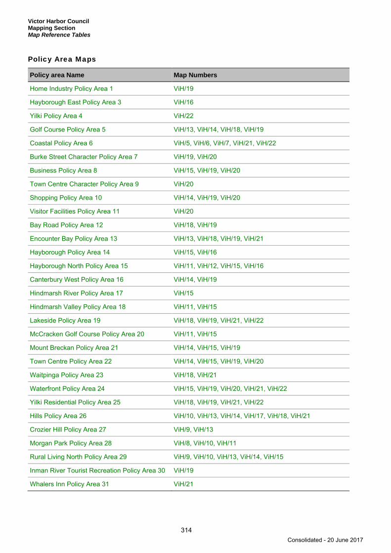
Victor Harbor Council Mapping Section Map Reference Tables
314
Policy Area Maps
Policy area Name Map Numbers
Home Industry Policy Area 1 ViH/19
Hayborough East Policy Area 3 ViH/16
Yilki Policy Area 4 ViH/22
Golf Course Policy Area 5 ViH/13, ViH/14, ViH/18, ViH/19
Coastal Policy Area 6 ViH/5, ViH/6, ViH/7, ViH/21, ViH/22
Burke Street Character Policy Area 7 ViH/19, ViH/20
Business Policy Area 8 ViH/15, ViH/19, ViH/20
Town Centre Character Policy Area 9 ViH/20
Shopping Policy Area 10 ViH/14, ViH/19, ViH/20
Visitor Facilities Policy Area 11 ViH/20
Bay Road Policy Area 12 ViH/18, ViH/19
Encounter Bay Policy Area 13 ViH/13, ViH/18, ViH/19, ViH/21
Hayborough Policy Area 14 ViH/15, ViH/16
Hayborough North Policy Area 15 ViH/11, ViH/12, ViH/15, ViH/16
Canterbury West Policy Area 16 ViH/14, ViH/19
Hindmarsh River Policy Area 17 ViH/15
Hindmarsh Valley Policy Area 18 ViH/11, ViH/15
Lakeside Policy Area 19 ViH/18, ViH/19, ViH/21, ViH/22
McCracken Golf Course Policy Area 20 ViH/11, ViH/15
Mount Breckan Policy Area 21 ViH/14, ViH/15, ViH/19
Town Centre Policy Area 22 ViH/14, ViH/15, ViH/19, ViH/20
Waitpinga Policy Area 23 ViH/18, ViH/21
Waterfront Policy Area 24 ViH/15, ViH/19, ViH/20, ViH/21, ViH/22
Yilki Residential Policy Area 25 ViH/18, ViH/19, ViH/21, ViH/22
Hills Policy Area 26 ViH/10, ViH/13, ViH/14, ViH/17, ViH/18, ViH/21
Crozier Hill Policy Area 27 ViH/9, ViH/13
Morgan Park Policy Area 28 ViH/8, ViH/10, ViH/11
Rural Living North Policy Area 29 ViH/9, ViH/10, ViH/13, ViH/14, ViH/15
Inman River Tourist Recreation Policy Area 30 ViH/19
Whalers Inn Policy Area 31 ViH/21
Consolidated - 20 June 2017
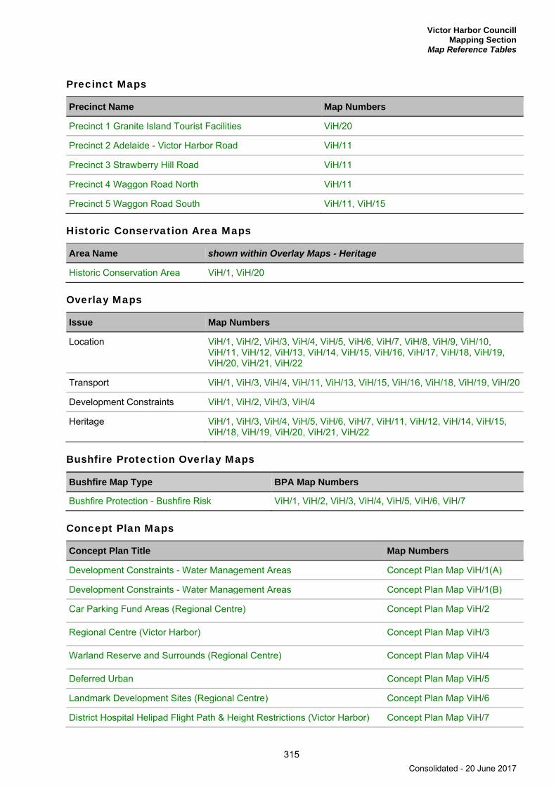
Victor Harbor Councill Mapping Section
Map Reference Tables
315
Precinct Maps
Precinct Name Map Numbers
Precinct 1 Granite Island Tourist Facilities ViH/20
Precinct 2 Adelaide - Victor Harbor Road ViH/11
Precinct 3 Strawberry Hill Road ViH/11
Precinct 4 Waggon Road North ViH/11
Precinct 5 Waggon Road South ViH/11, ViH/15
Historic Conservation Area Maps
Area Name shown within Overlay Maps - Heritage
Historic Conservation Area ViH/1, ViH/20
Overlay Maps
Issue Map Numbers
Location ViH/1, ViH/2, ViH/3, ViH/4, ViH/5, ViH/6, ViH/7, ViH/8, ViH/9, ViH/10, ViH/11, ViH/12, ViH/13, ViH/14, ViH/15, ViH/16, ViH/17, ViH/18, ViH/19, ViH/20, ViH/21, ViH/22
Transport ViH/1, ViH/3, ViH/4, ViH/11, ViH/13, ViH/15, ViH/16, ViH/18, ViH/19, ViH/20
Development Constraints ViH/1, ViH/2, ViH/3, ViH/4
Heritage ViH/1, ViH/3, ViH/4, ViH/5, ViH/6, ViH/7, ViH/11, ViH/12, ViH/14, ViH/15, ViH/18, ViH/19, ViH/20, ViH/21, ViH/22
Bushfire Protection Overlay Maps
Bushfire Map Type BPA Map Numbers
Bushfire Protection - Bushfire Risk ViH/1, ViH/2, ViH/3, ViH/4, ViH/5, ViH/6, ViH/7
Concept Plan Maps
Concept Plan Title Map Numbers
Development Constraints - Water Management Areas Concept Plan Map ViH/1(A)
Development Constraints - Water Management Areas Concept Plan Map ViH/1(B)
Car Parking Fund Areas (Regional Centre) Concept Plan Map ViH/2
Regional Centre (Victor Harbor) Concept Plan Map ViH/3
Warland Reserve and Surrounds (Regional Centre) Concept Plan Map ViH/4
Deferred Urban Concept Plan Map ViH/5
Landmark Development Sites (Regional Centre) Concept Plan Map ViH/6
District Hospital Helipad Flight Path & Height Restrictions (Victor Harbor) Concept Plan Map ViH/7
Consolidated - 20 June 2017
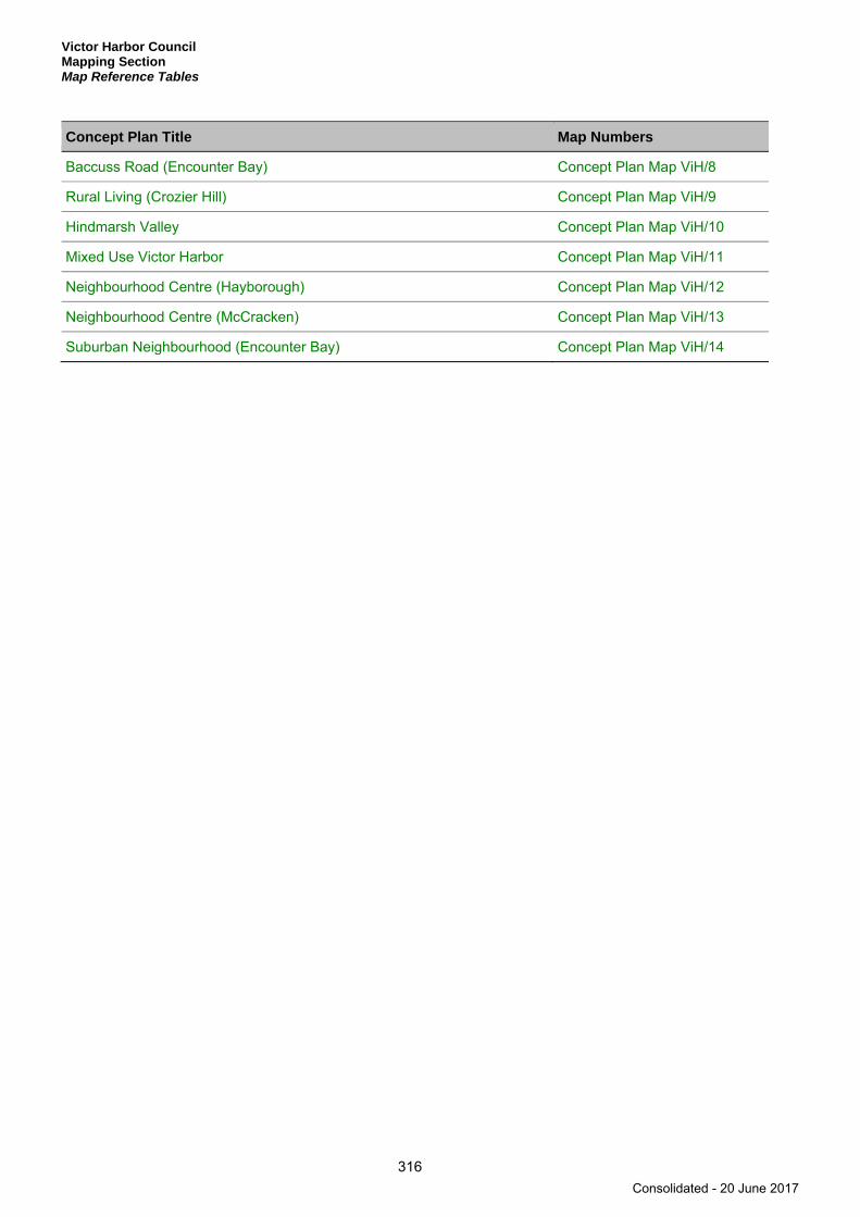
Victor Harbor Council Mapping Section Map Reference Tables
316
Concept Plan Title Map Numbers
Baccuss Road (Encounter Bay) Concept Plan Map ViH/8
Rural Living (Crozier Hill) Concept Plan Map ViH/9
Hindmarsh Valley Concept Plan Map ViH/10
Mixed Use Victor Harbor Concept Plan Map ViH/11
Neighbourhood Centre (Hayborough) Concept Plan Map ViH/12
Neighbourhood Centre (McCracken) Concept Plan Map ViH/13
Suburban Neighbourhood (Encounter Bay) Concept Plan Map ViH/14
Consolidated - 20 June 2017

Victor Harbor Council Mapping Section
Spatial Extent Maps
317
Spatial Extent Maps
Consolidated - 20 June 2017

Consolidated - 20 June 2017

VICT
ORHA
RBORRD
HINDMARSH
RD
INMANVALLEY RD
HINDMARSH TIERS RD
VICTO
R H
ARBO
RR
D
GOOLWA RD
MAIN S
OUTHRD
ADE
LAIDE
RD
NORTH TCE
ViH/1
ViH/6
ViH/5
ViH/4
ViH/3
ViH/2
ViH/7
ViH/8
ViH/9V ViH/12
ViH/19
ViH/20
iH/11
ViH/22
ViH/14
ViH/10
ViH/17
ViH/16
ViH/15
ViH/21
ViH/18
ViH/13
Myponga
Waitpinga
YankallilaCouncil
AlexandrinaCouncil
Land Not Withina Council Area
(Coastal Waters)
Victor Harbor
Port Elliot
Inman Valley
VICTOR HARBOR COUNCIL
Council Index Map
0 15 km
For the purposes of the Development Plan unless otherwise clearlyindicated, the zone/policy area/precinct boundaries depicted on or intendedto be fixed by Maps ViH/1 to Map ViH/22 inclusive shall be read as conformingin all respects (as the case may require) to the land division boundaries,to the centre line of roads or drain reserves or to the title boundaries, or toimaginary straight lines joining the positions defined by survey or by themeasurements shown on the said maps against which the said zone/policyarea/precinct boundaries are shown or otherwise indicated.
Consolidated - 20 June 2017

LandNot Within a Council
Area (Coastal Waters)
AlexandrinaCouncil
YankallilaCouncil
WILLOW CREEK
HINDMARSH TIERS
VICTORHARBOR
LOWERINMAN
VALLEY
HAYBOROUGH
BACK VALLEY
WAITPINGA
MYPONGA
PORT ELLIOT
MOUNTCOMPASS
HINDMARSH VALLEY
INMAN VALLEY
MOUNTJAGGED
GraniteIsland (RP)
Nixon - Skinner(CP)
Mount Billy (CP)
Hesperilla (CP)
Spring Mount (CP)
Stipiturus (CP)
Gum Tree Gully (CP)
Yulte(CP)
West Island (CP)
PullenIsland(CP)
Myponga (CP)
Newland Head (CP)
ViH/21
ViH/16
ViH/22
ViH/14ViH/15
ViH/20
ViH/11 ViH/12
ViH/6
ViH/2ViH/3
ViH/4
ViH/5
ViH/7
ViH/9
ViH/13
ViH/10
ViH/17 ViH/18ViH/19
ViH/8
PortElliot
Myponga
Waitpinga
Inman Valley
VictorHarbor
VIC
TOR
HAR
BOR
RD
AD
ELAIDE
RD
HIND
MAR
SH RD
HINDMARSH TIERS RD
INMA
N VALLEY
RD
PORT ELLIOT RD
MOUNT CO
MPASS-G
O OLWA RD
MAIN SOUTH RD
NORTH TCE
VICTOR HARBOR COUNCIL
Location Map ViH/1
0 15 km
Council Office
Railways
Conservation Park
Recreation Park
Development Plan BoundaryConsolidated - 20 June 2017
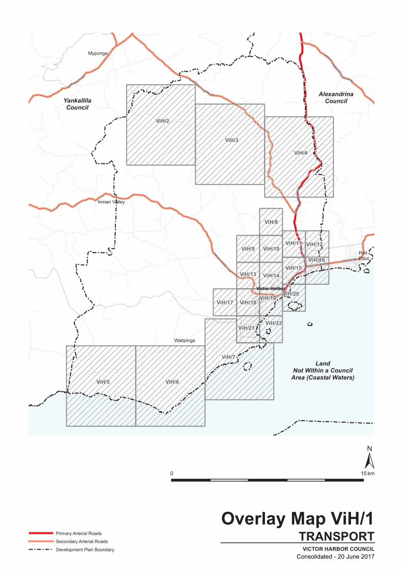
AlexandrinaCouncil
LandNot Within a Council
Area (Coastal Waters)
YankallilaCouncil
ViH/3
ViH/11
ViH/2
ViH/13
ViH/4
ViH/5 ViH/6
ViH/7
ViH/9 ViH/10
ViH/17 ViH/18 ViH/19
ViH/8
ViH/12
ViH/21
ViH/16
ViH/22
ViH/14ViH/15
ViH/20
Myponga
Waitpinga
Inman Valley
PortElliot
Victor Harbor HIND
MARSH RD
AD
ELAIDE
RD
VIC
TOR
HAR
BOR
RD
HINDMARSH T IERS
RD
INMAN VALLEY
RD
NORTH TCE
PORT ELLIOT RD
MOUNT CO
MPASS-G
O
OLWA RD
MAIN SOUTH RD
VICTOR HARBOR COUNCIL
Overlay Map ViH/1
TRANSPORT
0 15 km
Primary Arterial Roads
Secondary Arterial Roads
Development Plan BoundaryConsolidated - 20 June 2017

AlexandrinaCouncil
LandNot Within a Council
Area (Coastal Waters)
YankallilaCouncil
ViH/3
ViH/11
ViH/2
ViH/13
ViH/4
ViH/5 ViH/6
ViH/7
ViH/9 ViH/10
ViH/17 ViH/18 ViH/19
ViH/8
ViH/12
ViH/21
ViH/16
ViH/22
ViH/14ViH/15
ViH/20
Myponga
Waitpinga
Inman Valley
PortElliot
Victor HarborV
ICTO
R H
ARBO
R RD
AD
ELAIDE
RD
HIND
MARSH RD
PO
RT
ELLI
OT
RD
NORTH TCE
INMAN VALLEY
RD
HINDMARSH TIERS RD
GO
OLW
A RD
MAIN SOUTH
RD
PORT ELLIOT RD
VICTOR HARBOR COUNCIL
Overlay Map ViH/1DEVELOPMENT CONSTRAINTS
0 15 km
Mt Lofty Watershed Boundary
Development Plan BoundaryConsolidated - 20 June 2017

INMANVALLEY RD
HINDMARSH TIERS RD
VICTO
R H
ARBO
RR
D
GOOLWA RD
MAIN S
OUTHRD
ADE
LAIDE
RD
NORTH TCE
Myponga
Waitpinga
ViH/6
ViH/5
ViH/4
ViH/3
ViH/2
ViH/7
ViH/8
ViH/9ViH/11
ViH/22
ViH/14
ViH/10
ViH/17
ViH/16
ViH/15
ViH/21
ViH/18
ViH/13
Y
AlexandrinaCouncil
ankallila Council
Victor Harbor
PortElliot
Inman Valley
VICTOR HARBOR COUNCIL
Overlay Map ViH/1HERITAGE
0 15 km
Local heritage place
State heritage place
Historic Conservation Area
Development Plan Boundary
Heritage points are indicative only.For further information on State and Local Heritage Places and Contributoryitems please refer to the relevant tables within this document.
Consolidated - 20 June 2017
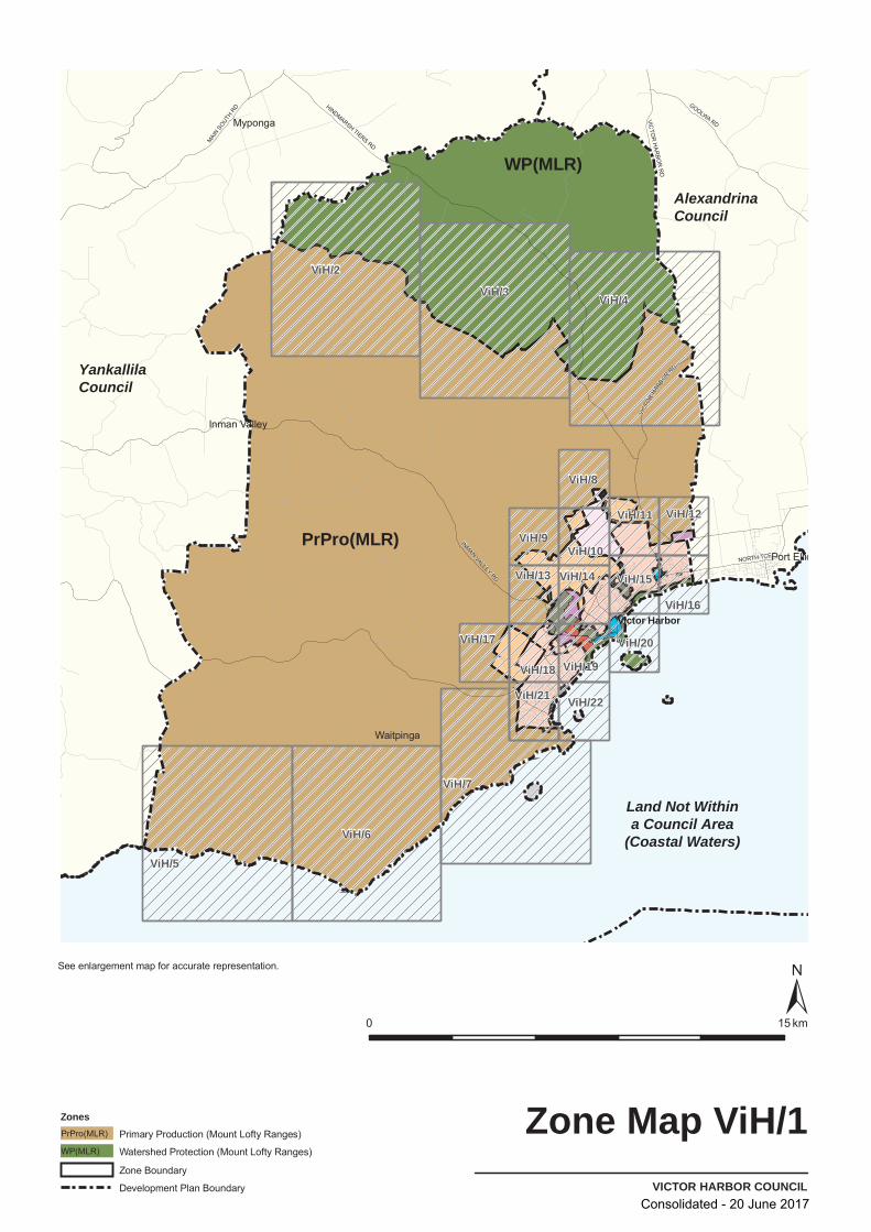
VICT
ORHA
RBORRD
INMANVALLEY RD
HINDMARSH TIERS RD
VICTO
R H
ARBO
RR
D
GOOLWA RD
MAIN S
OUTHRD
NORTH TCE
Myponga
Waitpinga
ViH/6
ViH/5
ViH/4ViH/3
ViH/2
ViH/7
V
ViH/10ViH/10
ViH/11ViH/11 ViH/12ViH/12
ViH/13ViH/13 ViH/15ViH/15
ViH/18ViH/18 ViH/19ViH/19
ViH/20ViH/20
ViH/21ViH/21
iH/8
ViH/9
ViH/22
ViH/14
ViH/17
ViH/16
PrPro(MLR)
WP(MLR)
Victor Harbor
Port Ellio
Inman Valley
VICTOR HARBOR COUNCIL
Zone Map ViH/1
0 15 km
ZonesPrimary Production (Mount Lofty Ranges)PrPro(MLR)
Watershed Protection (Mount Lofty Ranges)WP(MLR)
Zone Boundary
Development Plan Boundary
See enlargement map for accurate representation.
YankallilaCouncil
AlexandrinaCouncil
Land Not Withina Council Area
(Coastal Waters)
Consolidated - 20 June 2017
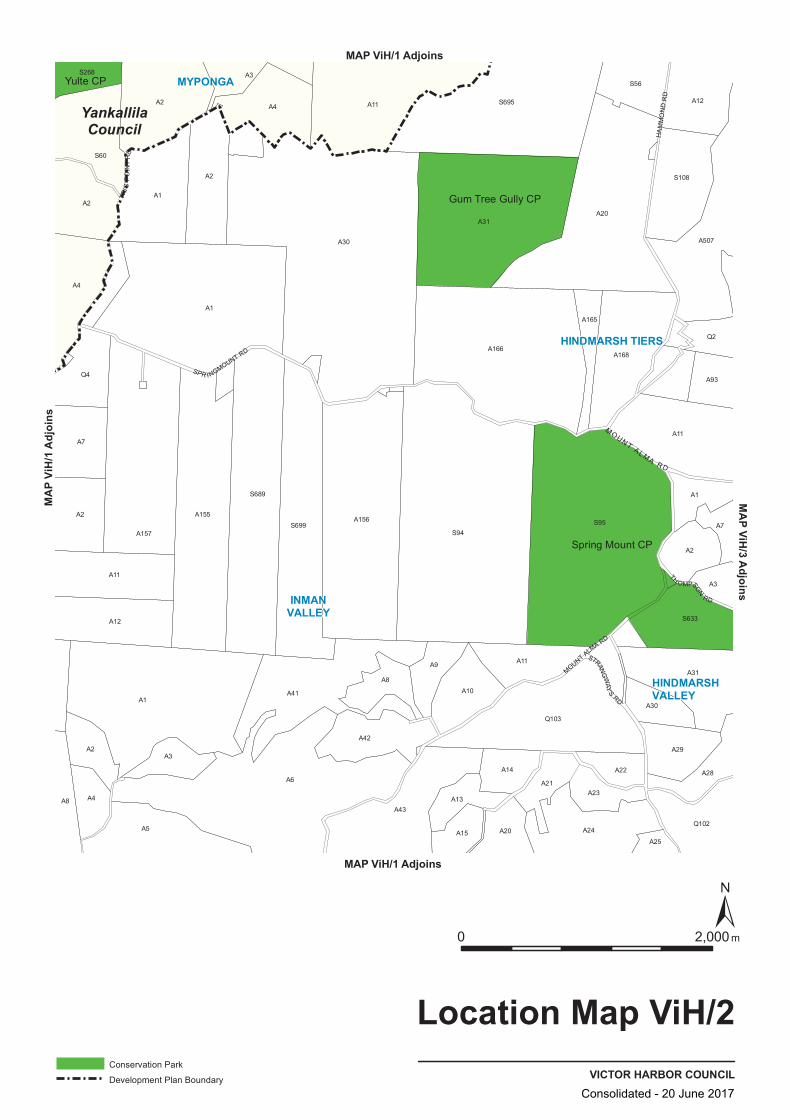
S94
A7
S689
A30
A8
A1
A31
A31
A12
A1
A156
S695
A11
A24
A168
A2
S56
Q2
A3
A155
A25
A11
A29
Q102
Q4
A4
A157
A43
A10
A13
A14
A21A23
A2
A2
A30
S633
A7
A2S699
A41
A9
A165
A22
S95
A4
A20
A507
A12
A4
A1
A5
A166
A3
A2
A2
A11
A15
S268
S60
A1
A28
A93
A6
A42
A20
Q103
A11
A3
S108
A8
MOUNT ALMA RD
HA
MM
ON
D R
D
TRIG
PO
INT
RD
SPR I NGMOUNT RD
STRANG
WAY
S RD
TH O MPSON
RD
MOUN T AL MA
RD
YankallilaCouncil
HINDMARSH TIERS
MYPONGA
HINDMARSHVALLEY
INMANVALLEY
Spring Mount CP
Gum Tree Gully CP
Yulte CP
VICTOR HARBOR COUNCIL
Location Map ViH/2
0 2,000 m
Conservation Park
Development Plan Boundary
MAP ViH/1 Adjoins
MAP ViH/1 Adjoins
MAP V
iH/1
Adjoi
nsMAP ViH/3 Adjoins
Consolidated - 20 June 2017

A20
A156
A2
A11
A8
A13
A31
A2
S268
A7
A28
A11
A93
A507
A12
S699
A41
Q2
A15
A14A6
Q4
A4
Q103
A29
S633
A7
A2
A1
A5
S60
A157
A2
A11
S94
A30
S56
S108
A12
A8
A3
A155
S689
A9
A21
S95
Q102
A165
A4
A42
A43
A1
A1
A102
A22
A24
A25
A31
S695
A1
A2
A30
A10
A11
A23
A166
A20
A168
A3
S P R I N G M O U N T
R D
YankallilaCouncil
DEVELOPMENT CONSTRAINTSVICTOR HARBOR COUNCIL
Overlay Map ViH/2
0 2,000 m
Mt Lofty Watershed Boundary
Development Plan Boundary
MAP ViH/1 Adjoins
MAP ViH/1 Adjoins
MAP V
iH/1
Adjoi
nsMAP ViH/3 Adjoins
Consolidated - 20 June 2017
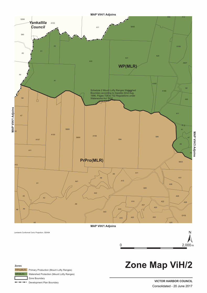
WP(MLR)
PrPro(MLR)
A24
A41
A43
A22
A7
A166
S695
A20
A168
S108
A2
A93
A42
A1
A102
A25
A165
A12
A1
A6
S94
A20
Q50
A31
A31
A4
A2A3
S699A156
Q4
A157
A11
A8
A21
S633
A11
A2
A13
Q102
A3
A1
A5
A1
A9
S95
A30
S56
S689
A7
S268
S60
A2
A14
A29
A28
Q2
A507
A8
A12
A155
A4
A2
A11
A30
A15
A10
A11
A23
S P R I N G M O U N T
R D
YankallilaCouncil
VICTOR HARBOR COUNCIL
Zone Map ViH/2
0 2,000m
Lamberts Conformal Conic Projection, GDA94
ZonesPrimary Production (Mount Lofty Ranges)PrPro(MLR)
Watershed Protection (Mount Lofty Ranges)WP(MLR)
Zone Boundary
Development Plan Boundary
MAP ViH/1 Adjoins
MAP ViH/1 Adjoins
MAP V
iH/1
Adjoi
nsMAP ViH/3 Adjoins
Schedule 2 Mount Lofty Ranges WatershedBoundary according to Gazette 22nd Aug.1996, Pages 728 to 732 Regulations underWaterworks Act 1932
Consolidated - 20 June 2017

A73
A127
A22
Q116
S680
A2
Q2
A502
A506
A23
A113
A7
Q11
S781
Q101
A62
Q102
A53
A501 A11
A2
A125
A1
A124
Q56
Q57
A5
A51
A50
A5
A507
S99
Q52
A2
A3
A2Q10
A72
A3
A5
A114
A129
A4
S104A10
A11
A93
Q51
Q54
S782
A119
A3
A6
A95
Q54
A1
A123
A504
S151
S679
A2
S198
A63
A65
A50
A66
A3A105
A2
A1
A11
A505
A112
A94
A1
A2
KENNY RD
THOMPSO
N
RD
BRAEBURN RD
ATT
RIL
L R
D
HAS
KE
TT R
D
HIND
MAR
SH
FALLS RD
CRES SBROOK RD
H I N D M A R S H
TI E
R
S R
D
SA
WP
I T R
D
NE
TT
LE
S H
I LL
RD
HINDMARSHTIERS
HINDMARSHVALLEY
SpringMount CP
MountBilly CP
VICTOR HARBOR COUNCIL
Location Map ViH/3
0 2,000 m
Conservation Park
MAP ViH/1 Adjoins
MAP ViH/1 Adjoins
MAP V
iH/1
Adjoi
nsMA
P ViH
/2 Ad
joins
MAP ViH/4 Adjoins
Consolidated - 20 June 2017
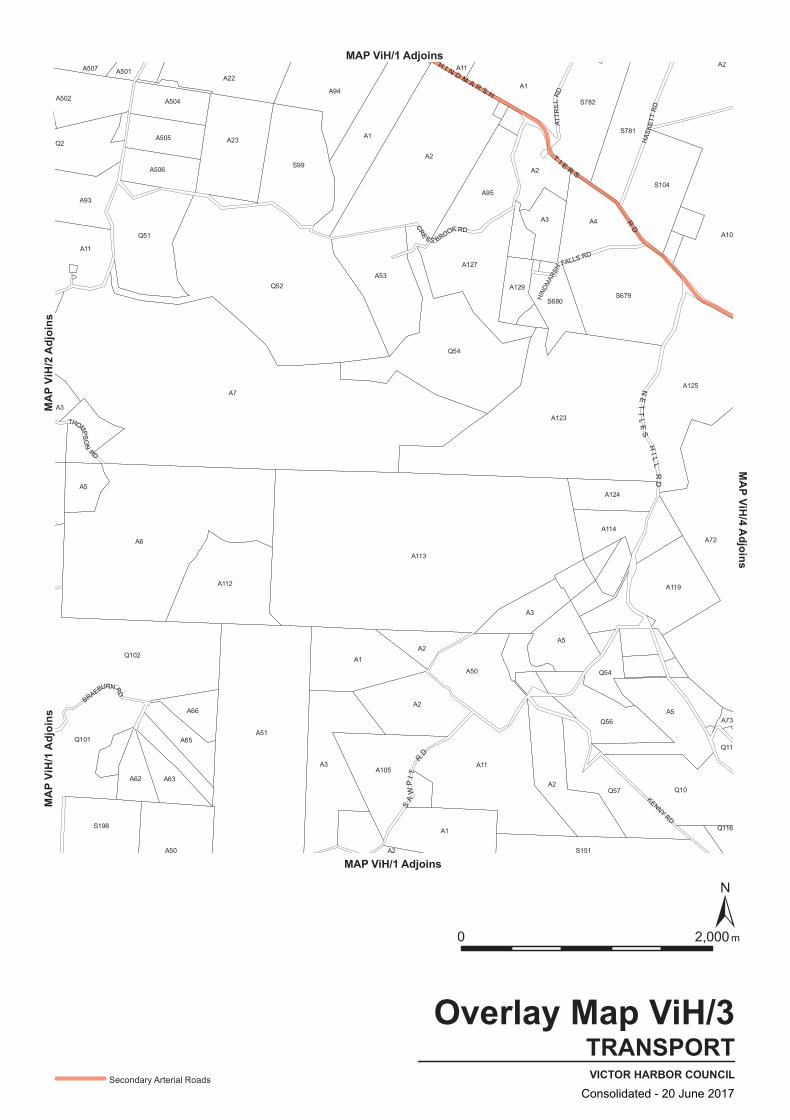
A2
Q2
A502
A506
A23
A113
A73
Q11
S781
Q101
A62
Q102
A53
A501 A11
A2
A125
A1
A7
Q56
Q57
A5
A51
A50
A5
A507
S99
Q52
A2
A3
A2Q10
A72
A3
A5
A114
A129
A4
S104
A10
A11
A93
Q51
Q54
S782
A119
A3
A6
A95
Q54
A1
A123
A504
S151
S679
A2
S198
A63
A65
A50
A66
A3A105
A2
A1
A11
A505
A112
A94
A1
A2
A127
A22
Q116
S680
A124
KENNY RD
THOMPS
ON
RD
BRAEBURN RD
ATT
RIL
L R
D
HAS
KE
TT R
D
HIND
MAR
SH
FALLS RD
CRE
S S BROOK RD
H I N D M A R S H
T I E R S
RD
SA
WP
I T R
D
NE
TT
LE
S H
I LL
RD
TRANSPORTVICTOR HARBOR COUNCIL
Overlay Map ViH/3
0 2,000 m
Secondary Arterial Roads
MAP ViH/1 Adjoins
MAP ViH/1 Adjoins
MAP V
iH/1
Adjoi
nsMA
P ViH
/2 Ad
joins
MAP ViH/4 Adjoins
Consolidated - 20 June 2017
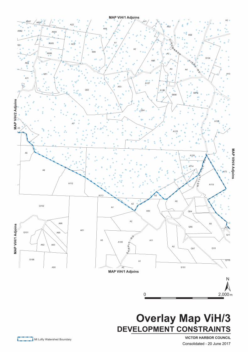
A5
A73
A94
A53A127
A52
A65
A50
A112
A11
A93
A507 A501
A23
A11
A119
A95S104
A53
A10
Q101
A502 A504
A3
A114
A72
Q11
Q116
A1
S680
A4
A7
Q51
A505
A22
A1
A113
Q56
S99
A3
Q52
A50
A5
A2Q57
Q102
A6
A51
A2
Q54
A2
A2
S198
A62
A66
A506
A1A2
A2
A3
A5
A125
A129
A2
S679
A63
A3
Q2
A105
A124
A123
S151
Q10
A11
Q54
HI N
DM
A RS H
T I E RS
RD
SA
WP
I T R
D
NE
TT
LE
HI L
L R
D
DEVELOPMENT CONSTRAINTSVICTOR HARBOR COUNCIL
Overlay Map ViH/3
0 2,000 m
Mt Lofty Watershed Boundary
MAP ViH/1 Adjoins
MAP ViH/1 Adjoins
MAP V
iH/1
Adjoi
nsMA
P ViH
/2 Ad
joins
MAP ViH/4 Adjoins
Consolidated - 20 June 2017
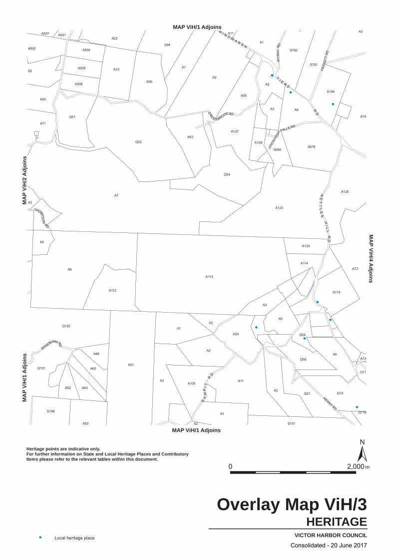
A2
Q2
A502
A506
A23
A113
A73
Q11
S781
Q101
A62
Q102
A53
A501 A11
A2
A125
A1
A7
Q56
Q57
A5
A51
A50
A5
A507
S99
Q52
A2
A3
A2Q10
A72
A3
A5
A114
A129
A4
S104
A10
A11
A93
Q51
Q54
S782
A119
A3
A6
A95
Q54
A1
A123
A504
S151
S679
A2
S198
A63
A65
A50
A66
A3A105
A2
A1
A11
A505
A112
A94
A1
A2
A127
A22
Q116
S680
A124
KENNY RD
THOMPS
ON
RD
BRAEBURN RD
ATT
RIL
L R
D
HAS
KE
TT R
D
HIND
MAR
SH
FALLS RD
CRE
S S BROOK RD
H I N D M A R S H
T I E R S R
D
SA
WP
I T R
D
NE
TT
LE
S H
I LL
RD
HERITAGEVICTOR HARBOR COUNCIL
Overlay Map ViH/3
0 2,000 m
Local heritage place
Heritage points are indicative only.For further information on State and Local Heritage Places and ContributoryItems please refer to the relevant tables within this document.
MAP ViH/1 Adjoins
MAP ViH/1 Adjoins
MA
P Vi
H/1
Adj
oins
MA
P Vi
H/2
Adj
oins
MA
P ViH/4 A
djoins
Consolidated - 20 June 2017
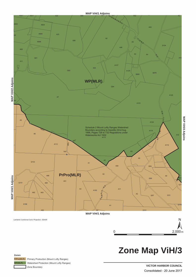
WP(MLR)
PrPro(MLR)
205o
180o
488m
1463m
A93
A501
A504
S151
A2
A66
A22
Q52
A3
A2
A50
A3
A113
A5
Q10
A94
A53
A502
A1
A95
Q54
A2
A10
A6
A11
Q51
A51
A2
A73
Q116
A1
A3
S680
S104
A2
S198
A62
A65
Q102
A3
A505 A23
A114
Q101
A506
A105
A2
Q56
A72
Q2
A507
A11
A124
Q54
A125
Q11
S99
A11
A4
S679
A63
A50
A112
A1
A2
A123
Q57
A5
A119
A53
A129
A127
A52
A5
A7
SA
WP
I T R
D
H I N D M A R S H
T I E R S R
D
NE
TT
LE
HI L
L R
D
VICTOR HARBOR COUNCIL
Zone Map ViH/3
0 2,000m
Lamberts Conformal Conic Projection, GDA94
Zones
Primary Production (Mount Lofty Ranges)PrPro(MLR)
Watershed Protection (Mount Lofty Ranges)WP(MLR)
Zone Boundary
MAP ViH/1 Adjoins
MAP ViH/1 Adjoins
MA
P Vi
H/1
Adj
oins
MA
P Vi
H/2
Adj
oins
MA
P ViH/4 A
djoins
Schedule 2 Mount Lofty Ranges WatershedBoundary according to Gazette 22nd Aug.1996, Pages 728 to 732 Regulations underWaterworks Act 1932
Consolidated - 20 June 2017
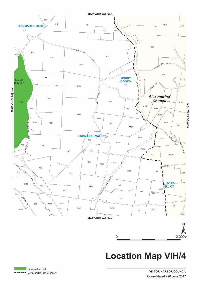
A1
A182
A2
A1
S2413
A60
A73
Q11
Q114
S132
A12
A2
S146
A188
A198
A20
A125
S161
S162
S2457
A13
A101
Q5A1
A23
S305
S290
A102
A192
S182
S306
S155
Q10
A72
Q12 A100
A100
S291
A101
S2414
A3
A187
A8
A100
A12
S152
A2
A629
S60
A22
A633
A10
S293
S69
A199
A13
A101
S59
S58
A632
Q23
A101
A52
S151
A631
A1
S145
A3
A639
A193
S183
A2
A50
A51
Q22
Q116
A2
A2
ANSELL RD
ROSIES RD
MOSQUITO HILL RD
KENNY RD
OLD
COAC
H R
D
CR
O
W S
NE
ST
RD
NE
TT
L E S
HI L L
RD
P A M B U L A
RD
VI C
TO
R H
AR
BO
R
RD
HI N
DM
AR
SH
TIE
RS
RD
AlexandrinaCouncil
HINDMARSH TIERS
PORTELLIOT
HINDMARSH VALLEY
MOUNTJAGGEDMount
Billy CP
VICTOR HARBOR COUNCIL
Location Map ViH/4
0 2,000 m
Conservation Park
Development Plan Boundary
MAP ViH/1 Adjoins
MAP ViH/1 Adjoins
MAP ViH/1 AdjoinsMA
P ViH
/3 Ad
joins
Consolidated - 20 June 2017

S161
A73
Q11
Q114
S132
A12
A2
A1
A188
A198
A20
A125
S182
S162
S2457
A13
A101
Q5A1
A23
S146
S290
A102
A192
S305
S306
S155
Q10
A72
Q12 A100
A100
S291
A101
S2414
A3
A187
A8
A100
A12
S152
A2
A629
S60
A22
A633
A10
S293
S69
A199
A13
A101
S59
S58
A632
Q23
A101
A52
S151
A631
A1
S145
A3
A639
A193
S183
A2
A50
A51
Q22
Q116
A2
A2
A182
A2
A1
S2413
A60
ANSELL RD
ROSIES RD
MOSQUITO HILL RD
KENNY RD
OLD
COAC
H R
D
CR
O
W S
NE
ST
RD
NE
TT
L E S
HI L L
RD
P A M B U L A
RD
HI N
DM
AR
SH
TIE
RS
RD
VI C
TO
R H
AR
BO
R
RD
AlexandrinaCouncil
TRANSPORTVICTOR HARBOR COUNCIL
Overlay Map ViH/4
0 2,000 m
Primary Arterial Roads
Secondary Arterial Roads
Development Plan Boundary
MAP ViH/1 Adjoins
MAP ViH/1 Adjoins
MAP ViH/1 AdjoinsMA
P ViH
/3 Ad
joins
Consolidated - 20 June 2017
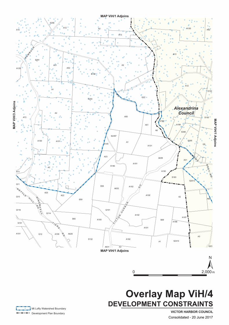
S152
A101
A3
A73
Q114
A100
Q101
A50
A2
A12 A100
A188
S132 A182A1
A22
S162
Q22
S183
A10
Q23
S306
S155
A60
Q5
A629
A72
Q11
A100
Q116
A102
S290
S305
A1
S293
A23
A102
A3
A187
Q12
A101
A101
A101
A12
A51
A2
S2413
A2
A2
S145
S69
S291
S2414
A199
A31
A52
A100
A631
A125
A101
S60
S59
S2457
A633
A1
A51
A192
A52
A13
A13
S151
Q10
A20
S58
S146
A2
A8
A639
A193
A198
CR
OW
S
NE
ST
RD
HI N
DM
AR
SH
T I E R
S
RD
N ET
T LE
HI L L
RD
PA
MB
UL
A
RD
VI C
TO
R H
AR
BO
R
RD
AlexandrinaCouncil
DEVELOPMENT CONSTRAINTSVICTOR HARBOR COUNCIL
Overlay Map ViH/4
0 2,000 m
Mt Lofty Watershed Boundary
Development Plan Boundary
MAP ViH/1 Adjoins
MAP ViH/1 Adjoins
MAP ViH/1 AdjoinsMA
P ViH
/3 Ad
joins
Consolidated - 20 June 2017
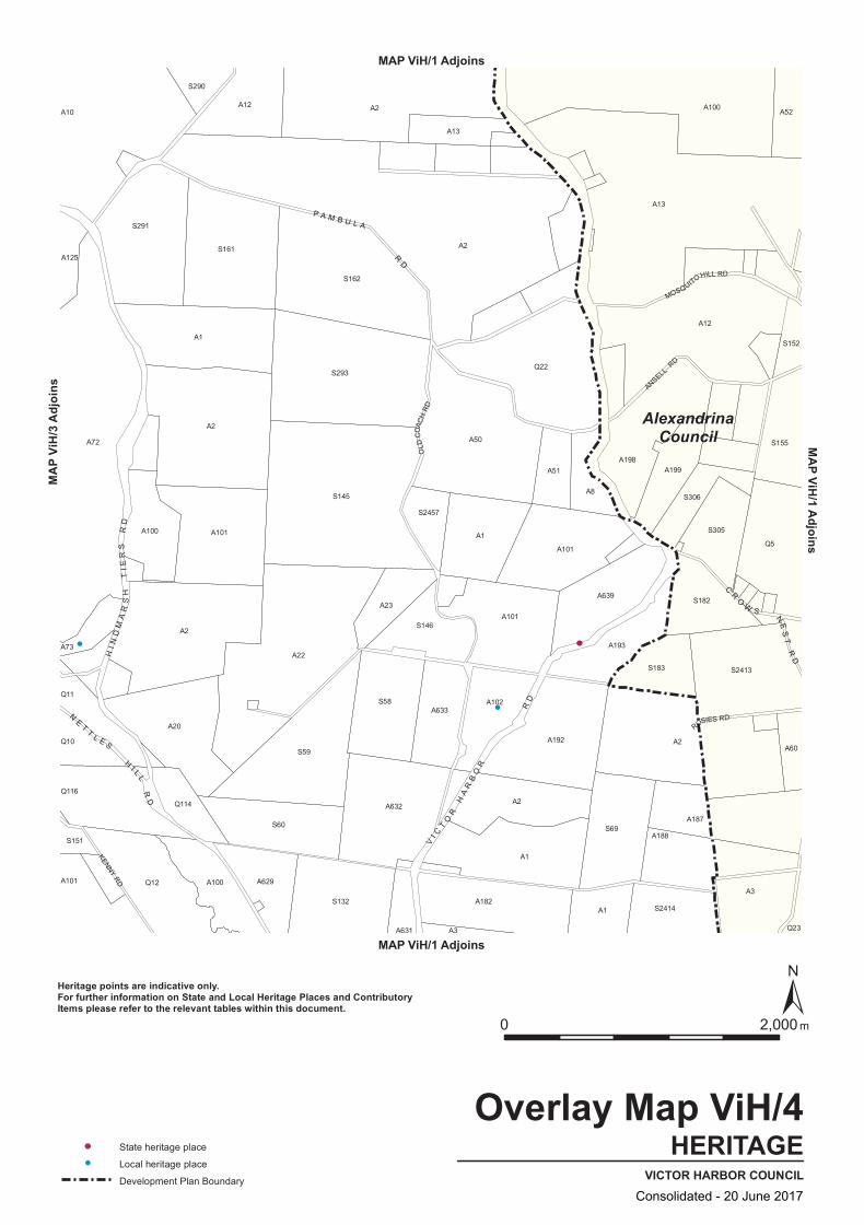
S161
A73
Q11
Q114
S132
A12
A2
A1
A188
A198
A20
A125
S182
S162
S2457
A13
A101
Q5A1
A23
S146
S290
A102
A192
S305
S306
S155
Q10
A72
Q12 A100
A100
S291
A101
S2414
A3
A187
A8
A100
A12
S152
A2
A629
S60
A22
A633
A10
S293
S69
A199
A13
A101
S59
S58
A632
Q23
A101
A52
S151
A631
A1
S145
A3
A639
A193
S183
A2
A50
A51
Q22
Q116
A2
A2
A182
A2
A1
S2413
A60
ANSELL RD
ROSIES RD
MOSQUITO HILL RD
KENNY RD
OLD
COAC
H R
D
CR
O
W S
NE
ST
RD
NE
TT
L E S
HI L L
RD
P A M B U L A
RD
HI N
DM
AR
SH
TIE
RS
RD
VI C
TO
R H
AR
BO
R
RD
AlexandrinaCouncil
HERITAGEVICTOR HARBOR COUNCIL
Overlay Map ViH/4
0 2,000 m
State heritage place
Local heritage place
Development Plan Boundary
Heritage points are indicative only.For further information on State and Local Heritage Places and ContributoryItems please refer to the relevant tables within this document.
MAP ViH/1 Adjoins
MAP ViH/1 Adjoins
MAP ViH/1 AdjoinsMA
P ViH
/3 Ad
joins
Consolidated - 20 June 2017

WP(MLR)
PrPro(MLR)
S2414
A3
S151
A101
A22
S58 A102
A101
A192
A101 A100
A631
Q10
A1
S293
S146
A50
A101
S291
A13
A31
A187
Q5
A2
A100
S145
A1
A101
A102
A10
A51
A100
A629
A73
Q116 Q101
S183
A3
Q23
S305
S306
A188
S2413
S155
S152
A52
Q12
S59
S162
A23
S69
A198
A2
A12
A13
A182
A72
Q114
A20
A2
S60
Q22
A8
A193
S290
A52
A12
A60
A1
A125
Q11
S2457
A633
A51
A2
A639
A2
A199
S132
A100
CR
O
W S
NE
ST
RDH
I ND
MA
RS
H T
IER
S R
D
N ET
T LE
HI L L
RD
P A M B U L A
RD
VI C
TO
R H
AR
BO
R
RD
AlexandrinaCouncil
VICTOR HARBOR COUNCIL
Zone Map ViH/4
0 2,000m
Lamberts Conformal Conic Projection, GDA94
ZonesPrimary Production (Mount Lofty Ranges)PrPro(MLR)
Watershed Protection (Mount Lofty Ranges)WP(MLR)
Zone Boundary
Development Plan Boundary
MAP ViH/1 Adjoins
MAP ViH/1 Adjoins
MAP ViH/1 AdjoinsMA
P ViH
/3 Ad
joins
Schedule 2 Mount Lofty Ranges WatershedBoundary according to Gazette 22nd Aug.1996, Pages 728 to 732 Regulations underWaterworks Act 1932
Consolidated - 20 June 2017
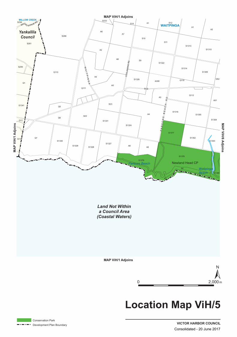
A1
A4
S23
S1376
A8
A4
S12
S1329
S1380
S1341
S1378
S22
A2
S1327
S1326
A3
S1314
S1305
Q112
S1309Q110
S1377
Q13
Q12
S259
Q111
S1328
S333
A7
S10
A1
Q110
S1304
S261
S1330
A6
S1331
A1
S11
S1313
S1302
S1310
Q1
Q5
A5
A6
S1303
A51
S258
Q7
Q6
S288
A8
S14
S1324
S9
A300
S1322
S1316
A2
Q52
A4
CO
OLA
WA
NG
RD
MOUNT SCRUB RD
PA
RS
ON
S B
EA
CH
RD
WA
I TP
I NG
A
R D
Land Not Withina Council Area
(Coastal Waters)
YankallilaCouncil
W IL L O W C R E EK
W AITPINGA
Newland Head CP
WaitpingaBeach
Parsons Beach
VICTOR HARBOR COUNCIL
Location Map ViH/5
0 2,000 m
Conservation Park
Development Plan Boundary
MAP ViH/1 Adjoins
MAP ViH/1 Adjoins
MAP V
iH/1
Adjoi
nsMAP ViH/6 Adjoins
Consolidated - 20 June 2017
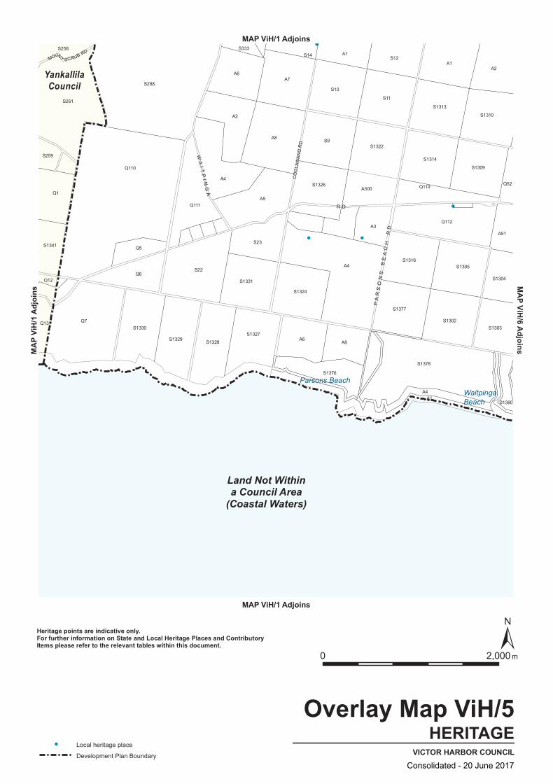
A2
A8
A4
S12
S1329
S1380A1
S1378
S22
S1377
S1327
S1326
A3
S1314
S1305
Q112
S1341
Q110 S1309
Q13
Q12
S259
Q111
S1328
S333
A7
S10
A1
Q110
S1304
S261
S1330
A6
S1331
A1
S11
S1313
S1302
S1310
Q1
Q5
A5
A6
S1303
A51
S258
Q7
Q6
S288
A8
S14
S1324
S9
A300
S1322
S1316
A2
Q52
A4
A4
S23
S1376
CO
OLA
WA
NG
RD
MOUNT SCRUB RD
PA
RS
ON
S B
EA
CH
RD
WA
I TP
I NG
A
R D
Land Not Withina Council Area
(Coastal Waters)
YankallilaCouncil
WaitpingaBeach
Parsons Beach
HERITAGEVICTOR HARBOR COUNCIL
Overlay Map ViH/5
0 2,000 m
Local heritage place
Development Plan Boundary
Heritage points are indicative only.For further information on State and Local Heritage Places and ContributoryItems please refer to the relevant tables within this document.
MAP ViH/1 Adjoins
MAP ViH/1 Adjoins
MAP V
iH/1
Adjoi
nsMAP ViH/6 Adjoins
Consolidated - 20 June 2017
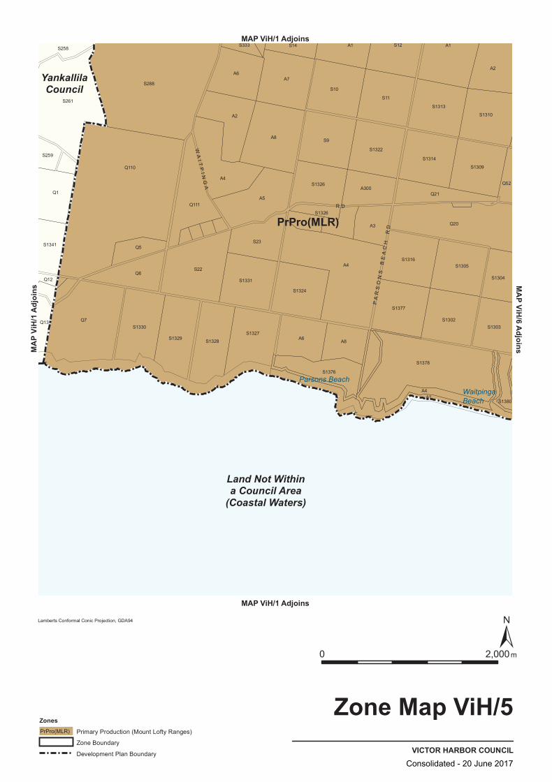
PrPro(MLR)
S1380
S1310
Q52
S12
Q1
S258
S1330
S1329
S288
A1
A4
S1313
S1302
Q21
Q12
A7
A3
A2
S261
S22
S1327
S23
S10
A4
S1303
A6
S14
S9
S1377
A1
S259
Q7
Q110
Q111
A2
S1331
S1326
S1326
S11
S1316
Q13
S1341
Q6
S1328
A8
S1324
A6
S1378
S1309
A4
A5
A8
S1322
S1314
S1305
S1304
Q20
A1
Q5
S1376
S333
A300
PA
RS
ON
S B
EA
CH
RD
WA
I TP
I NG
A
R D
Land Not Withina Council Area
(Coastal Waters)
YankallilaCouncil
WaitpingaBeach
Parsons Beach
VICTOR HARBOR COUNCIL
Zone Map ViH/5
0 2,000m
Lamberts Conformal Conic Projection, GDA94
ZonesPrimary Production (Mount Lofty Ranges)PrPro(MLR)
Zone Boundary
Development Plan Boundary
MAP ViH/1 Adjoins
MAP ViH/1 Adjoins
MAP V
iH/1
Adjoi
nsMAP ViH/6 Adjoins
Consolidated - 20 June 2017
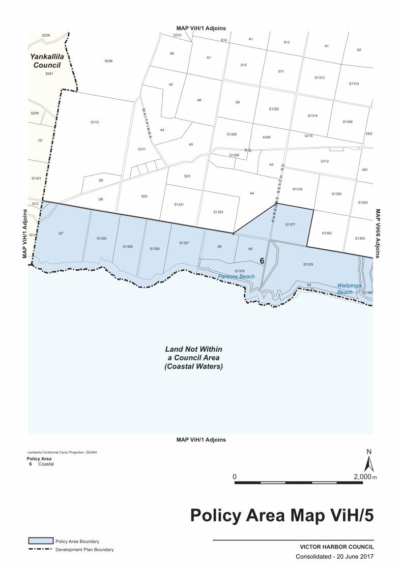
Q52
Q13
Q111
S14
S1309
S258
S261
S23
A6
S9
Q1
S1328
A4
S1327
S1376
A7
A4
S1310
S1304
S1341
A2
S1331
S1326
S1326
S10
A4
A300
S1377
S1378
S1303
A1
A1
Q12Q6
S1330
A8
A6
S1302
S12
S1329
A5
S1380
A8
S1322
Q112
A51
S259
Q110
S288
A2
S1324
A3
S11
S1316
S1314
Q7
Q5
S22
S333
S1313
S1305
Q110
A1
PA
RS
ON
S B
EA
CH
RD
WA
I TP
I NG
A
R D
Land Not Withina Council Area
(Coastal Waters)
YankallilaCouncil
6
WaitpingaBeach
Parsons Beach
VICTOR HARBOR COUNCIL
Policy Area Map ViH/5
0 2,000 m
Lamberts Conformal Conic Projection, GDA94
Policy Area Boundary
Development Plan Boundary
Policy Area 6 Coastal
MAP ViH/1 Adjoins
MAP ViH/1 Adjoins
MAP V
iH/1
Adjoi
nsMAP ViH/6 Adjoins
Consolidated - 20 June 2017

A17
S296
A4
A303
S1380
S1381
S297
Q42
A1
Q13
S18
S361
Q12
Q15
S1304
S5
A2
A302
S370
A11
Q14
S399
A5
Q53 A3
A6
S1303
A51
S17
A16
A2
Q52
S347
Q44
A100
FRANCIS RD
PITK
IN R
D
DE
NN
I S
RD
WA
I TP
I NG
A R D
Land Not Withina Council Area
(Coastal Waters)
WAITPINGA
Newland Head CP
Newland Head
VICTOR HARBOR COUNCIL
Location Map ViH/6
0 2,000 m
Conservation Park
Development Plan Boundary
MAP ViH/1 Adjoins
MAP ViH/1 Adjoins
MAP ViH/1 AdjoinsMA
P ViH
/5 Ad
joins
MAP ViH/7 Adjoins
Consolidated - 20 June 2017
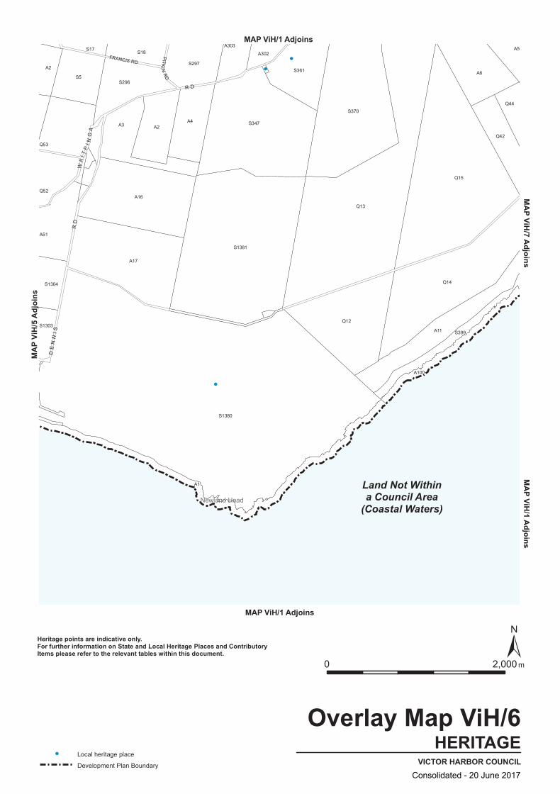
S297
A303
S1380
A17
S1381
Q42
A1
Q13
S18
S361
Q12
Q15
S1304
S5
A2
A302
S370
A11
Q14
S399
A5
Q53
A3
A6
S1303
A51
S17
A16
A2
Q52
S347
Q44
A100
S296
A4
FRANCIS RD
PITK
IN R
D
DE
NN
I S
RD
WA
I TP
I NG
A R D
Land Not Withina Council Area
(Coastal Waters)Newland Head
HERITAGEVICTOR HARBOR COUNCIL
Overlay Map ViH/6
0 2,000 m
Local heritage place
Development Plan Boundary
Heritage points are indicative only.For further information on State and Local Heritage Places and ContributoryItems please refer to the relevant tables within this document.
MAP ViH/1 Adjoins
MAP ViH/1 Adjoins
MAP ViH/1 AdjoinsMA
P ViH
/5 Ad
joins
MAP ViH/7 Adjoins
Consolidated - 20 June 2017

PrPro(MLR)
S296
A2
S1380
S17
A2A3
S5
Q12
Q15
S399
Q53
Q42
S1303
S361
A5
A17
A16
S18S297 S370
Q13
A11
A100
A1
S1381
S347
Q44
A303 A302 A6
A4
Q14S1304
Q20
Q52
W A I T P I N G A
R D
DE
NN
I S
RD
Land Not Withina Council Area
(Coastal Waters)Newland Head
VICTOR HARBOR COUNCIL
Zone Map ViH/6
0 2,000m
Lamberts Conformal Conic Projection, GDA94
ZonesPrimary Production (Mount Lofty Ranges)PrPro(MLR)
Zone Boundary
Development Plan Boundary
MAP ViH/1 Adjoins
MAP ViH/1 Adjoins
MAP ViH/1 AdjoinsMA
P ViH
/5 Ad
joins
MAP ViH/7 Adjoins
Consolidated - 20 June 2017

180o
180o
Q52
Q12
A11
S361
S399
S1304
Q42
A302
S1303
S297
A100
A1
A16
Q44
S1380
A51
A2
A17
A3
Q13
Q15
Q14
A6
A5
Q53
S296
A4
S17
S1381
S347
S370
A303
A2
S5
S18
W A I T P I N G A
R D
DE
NN
I S
RD
Land Not Withina Council Area
(Coastal Waters)
6
Newland Head
VICTOR HARBOR COUNCIL
Policy Area Map ViH/6
0 2,000 m
Lamberts Conformal Conic Projection, GDA94
Policy Area Boundary
Development Plan Boundary
Policy Area 6 Coastal
MAP ViH/1 Adjoins
MAP ViH/1 Adjoins
MAP ViH/1 AdjoinsMA
P ViH
/5 Ad
joins
MAP ViH/7 Adjoins
Consolidated - 20 June 2017

SEE MAP ViH/22SEE MAP ViH/21
A3
Q50 A61
A4
S375A5
S3
Q44
A100
A1
A3
S725
S188S26
A60
Q42
A91
A2
A10
A2
S167
A91
Q49
A1000
Q24
Q23
A22
A9A21
Q14
A11
S399
A5
A21
A91
S360
S400
S27
S185
A346A2
Q46
NEVIN AV
KIN
GS
BE
AC
H R
D
JOY
ST
B LUFF CR
SOLWAY CR
FELL ST
STON
E H
UT C CT
CLAIR AV
R
O SEMARY C
T
DODS
ON
RD
BOLGER WY
PETR
EL AV
DAVIES ST
JAGGER RD
DE
PLE
DG
E R
D
BA
UM
RD
WH
AL
ER
S R
D
R A N GE
R D
TH
RE
E G
UL
LI E
S R
D
FR
AN
KL
I N P
DE
B A T T Y E
R D
W A I T P I N G A
R D
DU
MP
RD
Land Not Withina Council Area
(Coastal Waters)
ENCOUNTER BAY
WAITPINGA
WestIsland CP
NewlandHead CP
West Island
Wright Island
King Beach
King Head
KongkengguwarPetrel Cove
Rosetta Harbor
Rosetta Head
EncounterBay
VICTOR HARBOR COUNCIL
Location Map ViH/7
0 2,000 m
Local Reserves
Conservation Park
Development Plan Boundary
MAP ViH/1 Adjoins
MAP ViH/1 Adjoins
MAP V
iH/1
Adjoi
nsMAP ViH/1 Adjoins
MAP ViH/21 Adjoins MAP ViH/22 AdjoinsMA
P ViH
/6 Ad
joins
MAP ViH/22 Adjoins
Consolidated - 20 June 2017
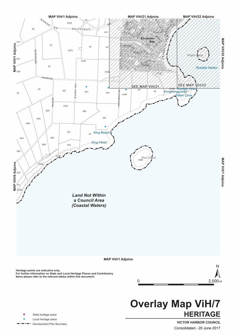
SEE MAP ViH/22SEE MAP ViH/21S3
Q44
A100
A1
Q23
S725
S188S26
A3
A60
Q42
A91
A2
A10
A2
S167
A91
A3
A1000
Q24
A5
A22
A9A21
Q14
A11
S399
A5
A21
A91
S360
S400
S27S185
A346A2
Q46
Q50
Q49
A4
S375
A61
JOY
ST
B LUFF CR
SOLWAY CR
FELL ST
STON
E H
UT C CT
CLAIR AV
R
O SEMARY C
T
DODS
ON
RD
BOLGER WY
PETR
EL AV
DAVIES ST
JAGGER RD
DE
PLE
DG
E R
D
BA
UM
RD
NEVIN AV
KIN
GS
BE
AC
H R
D
WH
AL
ER
S R
D
R A N GE
R D
DU
MP
RD
FR
AN
KL
I N P
DE
TH
RE
E G
UL
LI E
S R
D
B A T T Y E
R D
W A I T P I N G A
R D
Land Not Withina Council Area
(Coastal Waters)
West Island
Wright Island
King Beach
King Head
KongkengguwarPetrel Cove
Rosetta Harbor
Rosetta Head
EncounterBay
HERITAGEVICTOR HARBOR COUNCIL
Overlay Map ViH/7
0 2,000 m
State heritage place
Local heritage place
Development Plan Boundary
Heritage points are indicative only.For further information on State and Local Heritage Places and ContributoryItems please refer to the relevant tables within this document.
MAP ViH/1 Adjoins
MAP ViH/1 Adjoins
MAP V
iH/1
Adjoi
nsMAP ViH/1 Adjoins
MAP ViH/21 Adjoins MAP ViH/22 AdjoinsMA
P ViH
/6 Ad
joins
MAP ViH/22 Adjoins
Consolidated - 20 June 2017
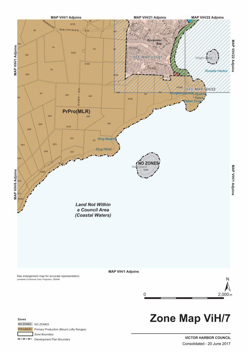
PrPro(MLR)
NO ZONES
SEE MAP ViH/22
SEE MAP ViH/21
Q24
A91
S375
A91
A1
S27
Q49
A21
A3
S399
Q46
A4
A21
A91
A60
Q42
A22
S360
S167
A3
A10
A5
A9
Q50
A2
S3
A1000
A11
A100
A61
S185
A346
Q44
A2
A2
Q14
S400
S26
Q23
A5
S725
S188
DODS
ON
RD
B LUFF CR
NEVIN AV
SOLWAY CR
FELL ST
STON
E H
UT C CT
CLAIR AV
R
O SEMARY C
T
BOLGER WY
PETR
EL AV
WH
AL
ER
S R
D
W A I T P I N G A R D
RANGE R D
FR
AN
KL
I N P
DE
DU
MP
RD
TH
RE
E G
UL
LI E
S R
D
B A T T Y E
R D
Land Not Withina Council Area
(Coastal Waters)
West Island
Wright Island
King Beach
King Head
Kongkengguwar
Petrel Cove
Rosetta Harbor
RosettaHead
EncounterBay
VICTOR HARBOR COUNCIL
Zone Map ViH/7
0 2,000m
Lamberts Conformal Conic Projection, GDA94
ZonesNO ZONESNO ZONES
Primary Production (Mount Lofty Ranges)PrPro(MLR)
Zone Boundary
Development Plan Boundary
See enlargement map for accurate representation.
MAP ViH/1 Adjoins
MAP ViH/1 Adjoins
MAP V
iH/1
Adjoi
nsMAP ViH/1 Adjoins
MAP ViH/21 Adjoins MAP ViH/22 AdjoinsMA
P ViH
/6 Ad
joins
MAP ViH/22 Adjoins
Consolidated - 20 June 2017
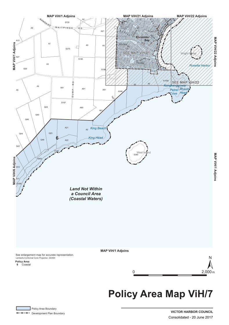
SEE MAP ViH/21
SEE MAP ViH/22
180 o
A346
S26
A3
S167
S375
A1000
A91
A11
A4
A2
S399
S400
Q50
A22
A61
A91
S188
Q42
Q24
A2
A100
A3
Q44
Q49
Q23
A21
S360
A1
S725
A91
Q14
A10
A5
S27
A9
S185
A60
A2
A21
S3
A5
Q46
DODS
ON
RD
B LUFF CR
NEVIN AV
SOLWAY CR
FELL ST
STON
E H
UT C CT
CLAIR AV
R
O SEMARY C
T
BOLGER WY
PETR
EL AV
WH
AL
ER
S R
D
W A I T P I N G A R D
RANGE R D
FR
AN
KL
I N P
DE
DU
MP
RD
TH
RE
E G
UL
LI E
S R
D
B A T T Y E
R D
Land Not Withina Council Area
(Coastal Waters)
6
West Island
Wright Island
King Beach
King Head
KongkengguwarPetrelCove
Rosetta Harbor
RosettaHead
EncounterBay
VICTOR HARBOR COUNCIL
Policy Area Map ViH/7
0 2,000 m
Lamberts Conformal Conic Projection, GDA94
Policy Area Boundary
Development Plan Boundary
Policy Area 6 Coastal
See enlargement map for accurate representation.
MAP ViH/1 Adjoins
MAP ViH/1 Adjoins
MAP V
iH/1
Adjoi
nsMAP ViH/1 Adjoins
MAP ViH/21 Adjoins MAP ViH/22 AdjoinsMA
P ViH
/6 Ad
joins
MAP ViH/22 Adjoins
Consolidated - 20 June 2017
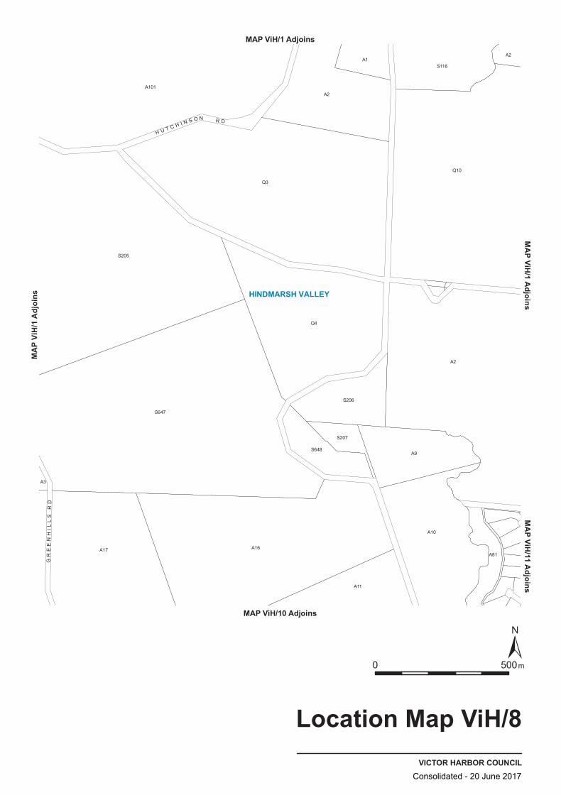
A11
A17
S647
S648
S207
S206
A16
Q3
A2
A9
A10
A81
Q4
S116
A3
S205
A2
A101
A1A2
Q10
GR
EE
NH
ILL
S R
D
H U T C H I N S O N R D
HINDMARSH VALLEY
VICTOR HARBOR COUNCIL
Location Map ViH/8
0 500m
MAP ViH/1 AdjoinsMA
P ViH
/1 Ad
joins
MAP ViH/1 Adjoins
MAP ViH/10 Adjoins
MAP ViH/11 Adjoins
Consolidated - 20 June 2017

OS
RuLDU
PrPro(MLR)
Q4
A9
Q10
A3
A101
A101
S648
S207
A1
A81
A2
Q3
A2
A10
S116
A16
A11
A100
S205
S206
A2
GR
EE
NH
ILL
S R
D
H U T C H I N S O N R D
VICTOR HARBOR COUNCIL
Zone Map ViH/8
0 500m
Lamberts Conformal Conic Projection, GDA94
Zones
Deferred UrbanDU
Open SpaceOS
Primary Production (Mount Lofty Ranges)PrPro(MLR)
Rural LivingRuL
Zone Boundary
MAP ViH/1 AdjoinsM
AP
ViH
/1 A
djoi
nsM
AP ViH
/1 Adjoins
MAP ViH/10 Adjoins
MA
P ViH/11 A
djoins
50m from bank
50mfrombank
Consolidated - 20 June 2017

A101
A9
Q3
S116A1
A2
A16
S205
S207
S206
A11
A81
Q10
A17
S647
Q4
A2
A2
A3
S648
A10
GR
EE
NH
ILL
S R
D
H U T C H I N S O N R D
28
VICTOR HARBOR COUNCIL
Policy Area Map ViH/8
0 500m
Lamberts Conformal Conic Projection, GDA94
Policy Area Boundary
Policy Area28 Morgan Park
MAP ViH/1 AdjoinsM
AP
ViH
/1 A
djoi
nsM
AP ViH
/1 Adjoins
MAP ViH/10 Adjoins
MA
P ViH/11 A
djoins
50mfrombank
Consolidated - 20 June 2017
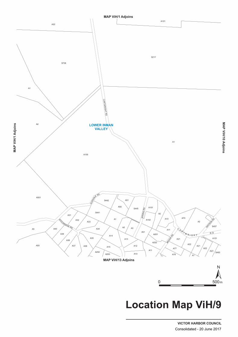
S445
A501
A39
A50
A51
A13
A1
A10
A11
A2
A201
A10
A101
S483
A40S457
A151
A50
A32
A203
A101
A202
A77
A21
A21
A1
A1
A2
A33
S441
A14
A3
A12
A51A11
S217
S726
A36
A102
A22A37
A35
A15
A70
A22
A1
A22
A34
S442
A202
A2
A78
A5
A150
A38
A31
A2
A23
GLE
NVA
LE RD
WAT
SON RD
BRO
OK RD
CA
RTW
RI G
HT
RD
SP
RIN
G R
D
STOCKRIDGE RD C A R T W R I G H T R D
LOWER INMANVALLEY
VICTOR HARBOR COUNCIL
Location Map ViH/9
0 500m
MAP ViH/1 AdjoinsMA
P ViH
/1 Ad
joins
MAP ViH/13 Adjoins
MAP ViH/10 Adjoins
Consolidated - 20 June 2017
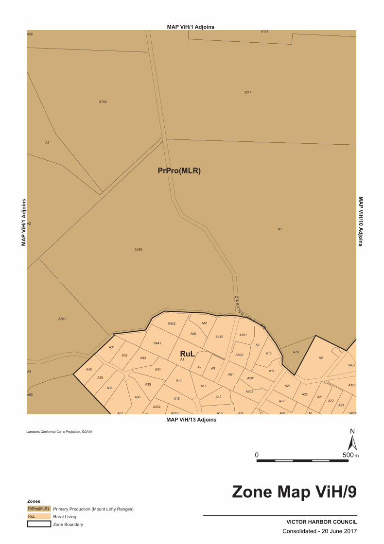
RuL
PrPro(MLR)
A31
A33
S445
A102A70
A22
A2
A1
A2
A34
A15 A12
A10 S483
A36
A2
A10
A11
A77 A22A23
S217
A501
A32
A13
A201
A78
A22
A35
A202
A203
S726
A101
A39
A50
S441
A202
A21
A1
A40
A51
A2
A1
A21
A5
A38
A37
S442
A14
A50
A3
A150
A51
A101
A11 A1
S457
A151
CA
RT
W
R I G H T R D
VICTOR HARBOR COUNCIL
Zone Map ViH/9
0 500m
Lamberts Conformal Conic Projection, GDA94
ZonesPrimary Production (Mount Lofty Ranges)PrPro(MLR)
Rural LivingRuL
Zone Boundary
MAP ViH/1 AdjoinsMA
P ViH
/1 Ad
joins
MAP ViH/13 Adjoins
MAP ViH/10 Adjoins
Consolidated - 20 June 2017
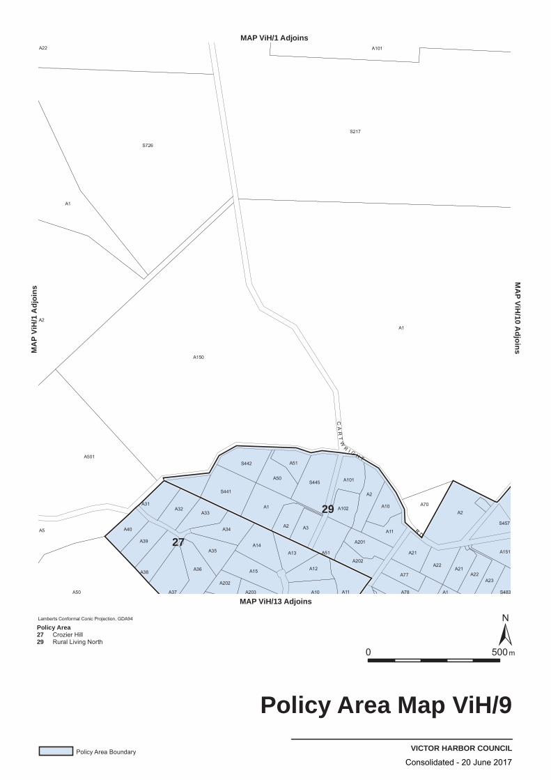
A36
A101
A40
A501
A39
A38
A31
A37
A3
A15
A13
A1
A201
A34
A202
S217
A102
A22
A1
A5
A32
A12
A10
S445
A11
A70
A2
A22
A51
A101
A10
A21
A21A22
A1
A1
S441
A2
A51
A11
S457
A2
A203
A202
A2
A77
A78
A23
A151
A50
A150
S726
A33
A35
S442
A14
A50
S483
CA
RT
W
R I G H T
RD
27
29
VICTOR HARBOR COUNCIL
Policy Area Map ViH/9
0 500m
Lamberts Conformal Conic Projection, GDA94
Policy Area Boundary
Policy Area2729
Crozier HillRural Living North
MAP ViH/1 AdjoinsM
AP
ViH
/1 A
djoi
ns
MAP ViH/13 Adjoins
MA
P ViH/10 A
djoins
Consolidated - 20 June 2017
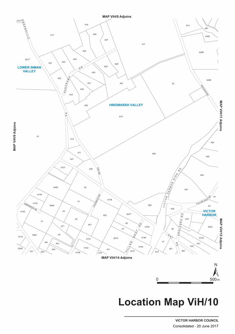
A2
A97
A54
A101
S483
A21
A20
S460
A51
A23
A51
A30
S477
A6
A11
A22
A31
A151
A153
S467
A154
A91
A2
A33
A17
A4
A28
A60 A2
A31
A1
A93
A52
A10
A11
A16
A57
A298
S557
A55
A1
S217
A37
A151
A26
A2
A101
A194
A193
A70
A10
A300
A81
A32
A152
A148
A38
A31
A50
A1
A56
A1
A71
A11
A32
A1
A25
A29
S479
A19
A21
A58
A299
A3
A24
A152
A1
A100
A18
A51
A50
A103
S464
A101
A10
A2
A27
A156
DAY
RD
SINKINSON RD
CO
LEBA
CH
RD
FULLER EAST
RD
WAG
GO
N RD
D A Y
RD
PA
NO
RA
MA
D R
FU
LL
ER
WE
ST
RD
VI C
TO
R H
AR
BO
R R
I NG
RD
GR
EE
NH
I LL
S
RD
AN
GL
ES
EA
RD
HINDMARSH VALLEY
VICTORHARBOR
LOWER INMANVALLEY
VICTOR HARBOR COUNCIL
Location Map ViH/10
0 500m
MAP ViH/8 Adjoins
MAP ViH/14 Adjoins
MAP V
iH/9
Adjoi
nsMAP ViH/15 Adjoins
MAP ViH/11 Adjoins
Consolidated - 20 June 2017

OS
RuL
RuL
RuL
DU
PrPro(MLR)
S464
A20
A10
A37
A2
A194
A193
A19
S557
A103
A1
A27
S483
A154
A148
A52
A60
A97
A56
A2
A31 A2
A298
A152
S217
A101
A100
A18A32
A54
A55
A23
A81
A31
A21
A2
A11
A51
A22
A32
A28
A153
A101
A52
A51
A3S477
A1
A21
A70
A31
A10
A101
A1
A1
S460
A4
A1
A2
A151
A1
A33
A25
A26
A50
A16
A11
A51
A300
A299
A91
A71
A11
S479
A6
A57
A24
A29
A151
A101
A152
A38
A10
A156
A101
A58
A50
A30
D A Y
RD
PA
NO
RA
MA
D R
FU
LL
ER
WE
ST
RD
AR
MS
TR
ON
G
RD
GR
EE
NH
I LL
S R
DA
NG
LE
SE
A R
D
VICTOR HARBOR COUNCIL
Zone Map ViH/10
0 500m
Lamberts Conformal Conic Projection, GDA94
Zones
Deferred UrbanDU
Open SpaceOS
Primary Production (Mount Lofty Ranges)PrPro(MLR)
Rural LivingRuL
Zone Boundary
MAP ViH/8 Adjoins
MAP ViH/14 Adjoins
MA
P Vi
H/9
Adj
oins
MA
P ViH/15 A
djoinsM
AP ViH
/11 Adjoins
50m from
bank
50mfrombank
Consolidated - 20 June 2017

A300
A26
A152
A20
A101
A1
A51
A151
A156
A19
A32
A31 A2
A58
A101
A1
A193
A2
A22
A298
A11
A10
A11A100
A194
A6
A10
A70
A103
A54
A55
A23A24
A27
A153
A91
A21
A38
A50
A1
A33
A25
A30
A29
A16
A31
A1
A52
A51
A10
A57
A50
A11
A51
A81
A151
A154
S460
A17
A2
A71
A148
A52
A101A21
A18
A28
A299
A4
A152
A2
S479
A1
A2
A1
A97A32
A31
S483
S464
A101
S217
A37
A3S477
A60
S557
A56
D A Y
RD
PA
NO
RA
MA
D R
FU
LL
ER
WE
ST
RD
AR
MS
TR
ON
G
RD
GR
EE
NH
I LL
S R
DA
NG
LE
SE
A R
D
29
26
28
VICTOR HARBOR COUNCIL
Policy Area Map ViH/10
0 500m
Lamberts Conformal Conic Projection, GDA94
Policy Area Boundary
Policy Area262829
HillsMorgan ParkRural Living North
MAP ViH/8 Adjoins
MAP ViH/14 Adjoins
MA
P Vi
H/9
Adj
oins
MA
P ViH/15 A
djoinsM
AP ViH
/11 Adjoins
50m from bank
Consolidated - 20 June 2017

A11
Q1166
A200
A100A11
A24
A301
A1161
A101
A3
S299
A2
A4
A14
A2
A9
A21
A29
A11
A130
Q202
A55
A64
A10
Q200
A23
A31
A12
S733
A45
A22
A2
A10
A5
A4
A4
A50
A503
A2
A500
A101
A56
A32
A28
A50
S298
A1010
A299
A6
A3
A3
A30
A11
Q201
A1
A2
A13
A30
A35
A8
A100
A2
A54
A1
A295
A1
A62
A31
A25
A1
A637
S295
FULL
ER EAST
RD
NA
NG
AW
OO
KA
TRK
RIVERWAY C
T
COROMANDEL DR
VI C
TO
R H
AR
BO
R R
D
VI C
TO
R
HA
RB
OR
R I N G
R D
AD
EL
AI D
E R
D
WA
GG
ON
RD
W A T E R P OR
T
RD
A R A B I A N
C T
S HE T L A N D C T
W E L C H R D
AP
PA
LO
OS
A D
R
LI P
I ZZ
AN
ER
DR
VICTORHARBOR
HAYBOROUGH
MCCRACKEN
HINDMARSH VALLEY
VICTOR HARBOR COUNCIL
Location Map ViH/11
0 500m
School
Local Reserves
MAP ViH/1 Adjoins
MAP ViH/15 Adjoins
MAP V
iH/10
Adjo
insMAP ViH/12 Adjoins
Consolidated - 20 June 2017
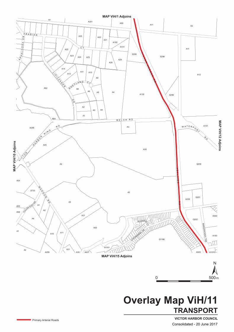
A11
A24
A301
A1161
A101
A3
S299
A2
A4
A11
A2
A9
A21
A29
A11
A130
Q202
A55
A64
A10
A14
A23
A31
A12
S733
A45
A22
A2
A10
A5
A4
A4
A50
A503
A2
A500
A101
A56
A32
A28
A50
S298
A1010
A299
A6
A3
A3
A30
A11
Q201
A1
A2
A13
A30
A35
A8
A100
A2
A54
A1
A295
A1
A62
A31
A25
A1
A637
S295
Q1166
A200
A100
Q200
COROMANDEL DR
RIVERWAY C
T
NA
NG
AW
OO
KA
TRK
FULL
ER EAST
RD
VI C
TO
R
HA
RB
OR
R I N G
R D
AD
EL
AI D
E R
D
VI C
TO
R H
AR
BO
R R
D
W A T E R P OR
T
RD
A R A B I A N
C T
S HE T L A N D C T
W E L C H R D
AP
PA
LO
OS
A D
R
LI P
I ZZ
AN
ER
DR
WA
GG
ON
RD
TRANSPORTVICTOR HARBOR COUNCIL
Overlay Map ViH/11
0 500m
Primary Arterial Roads
MAP ViH/1 Adjoins
MAP ViH/15 Adjoins
MAP V
iH/10
Adjo
insMAP ViH/12 Adjoins
Consolidated - 20 June 2017
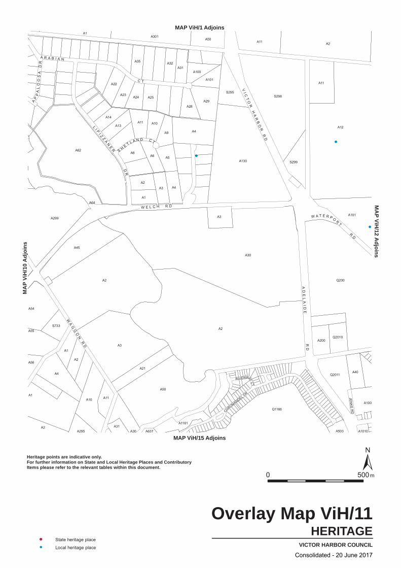
A1
A2
A11
Q200
A22
A8
A3
A9
A29
A130
A56
A2
A50
Q2010
Q2011
A62
A13
A23
A2
A1
A3
A11
A54
A55
A1A3
A1161
A40
A31
A4
A101
A2
A21
A503
A100
A1
A10
A50
S298
A11
A101
A31
A200
Q1166
A24
A6
A301
S299
A12
S733
A4
A295 A637
A2
A1010
A299
A4
A30
A2
A45
A14A11
A25
A32
A5
A100
A10
A30
A64
A35
A28
S295
COROMANDEL DR
RIVERWAY C
T
JEN
KE
RD
AD
EL
AI D
E R
D
VI C
TO
R H
AR
BO
R R
D
W A T E R P OR
T
RD
A R A B I A N
C T
W E L C H R D
S HE T L A N D C T
AP
PA
LO
OS
A D
R
LI P
I ZZ
AN
ER
DR
WA
GG
ON
RD
HERITAGEVICTOR HARBOR COUNCIL
Overlay Map ViH/11
0 500m
State heritage place
Local heritage place
Heritage points are indicative only.For further information on State and Local Heritage Places and ContributoryItems please refer to the relevant tables within this document.
MAP ViH/1 Adjoins
MAP ViH/15 Adjoins
MA
P Vi
H/1
0 A
djoi
nsM
AP ViH
/12 Adjoins
Consolidated - 20 June 2017
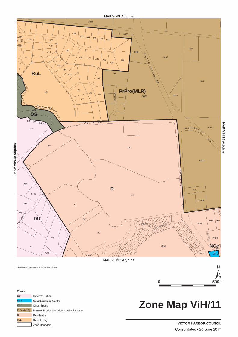
R
RuL
DU
PrPro(MLR)
OS
NCe
COROMANDEL DR
STIRLIN
G C
T
FULL
ER E
AST
RD
JENK
ER
D
RIVERWAY CT
A2
A30
A12
A62
A3
Q200
A200
A50
S298
Q950
A299
A1
A45
A4
A64
A101
A10
A11
A54
A29
A21
A301
Q2011
A55
S295
A5
A8
A9
A6S299
A7
A40
A22
A28
A31
A100
A23
A13
A32A35
A14
A25A24
A33
A26
A34
A36
S733
A27
A701
Q2010
A103
A41
A15
A295
A16
A303
A18
A56
A19
A20A119
A503
A107
A108
A1010
A109
A702
VICTOR HARBOR COUNCIL
Zone Map ViH/11
0050 m
Lamberts Conformal Conic Projection, GDA94
Zones
Deferred UrbanDU
Neighbourhood CentreNCe
Open SpaceOS
Primary Production (Mount Lofty Ranges)PrPro(MLR)
ResidentialR
Rural LivingRuL
Zone Boundary
MAP ViH/1 Adjoins
MAP ViH/15 Adjoins
sniojdA 01/
HiV PA
MM
AP
V1/
Hi2
j dA
oisn
50m from bank
50m from bank
AD
EL
AI D
ER
D
VI C
TO
RH
AR
BO
RR
D
W A T E R P OR
T
RD
W E L C H R D
WA
GG
ON
RD
Consolidated - 20 June 2017

18
28
20
15COROMANDEL DR
STIRLIN
G C
T
FULL
ER E
AST
RD
JENK
E R
D
RIVERWAY CT
A2
A30
A12
A62
A3
Q200
A200
A50
S298
Q950
A299
A1
A45
A4
A64
A101
A10
A11
A54
A29
A21
A301
Q2011
A55
S295
A5
A8
A9
A6S299
A40
A22
A28
A31
A100
A23
A13
A32A35
A14
A25A24
S733
A701
Q2010
A295
A56
A503 A1010A702
VICTOR HARBOR COUNCIL
Policy Area Map ViH/11
0050 m
Lamberts Conformal Conic Projection, GDA94
Policy Area Boundary
Policy Area15182028
Hayborough NorthHindmarsh ValleyMcCracken Golf CourseMorgan Park
MAP ViH/1 Adjoins
MAP ViH/15 Adjoins
sniojdA 01/
HiV PA
MM
AP
V1/
Hi2
j dA
oisn
50m from bank
AD
EL
AI D
ER
D
VI C
TO
RH
AR
BO
RR
D
W A T E R P OR
T
RD
W E L C H R D
WA
GG
ON
RD
Consolidated - 20 June 2017
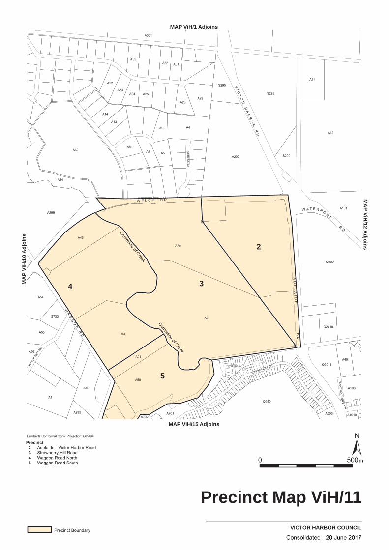
34
2
5 COROMANDEL DR
STIRLIN
G C
T
FULL
ER E
AST
RD
JENK
ER
D
RIVERWAY CT
JEN
KE
RD
A2
A30
A12
A62
A3
Q200
A200
A50
S298
Q950
A299
A1
A45
A4
A64
A101
A10
A11
A54
A29
A21
A301
Q2011
A55
S295
A5
A8
A9
A6S299
A40
A22
A28
A31
A100
A23
A13
A32A35
A14
A25A24
S733
A701
Q2010
A295
A56
A503 A1010A702
VICTOR HARBOR COUNCIL
Precinct Map ViH/11
0050 m
MAP ViH/1 Adjoins
MAP ViH/15 Adjoins
sniojdA 01/
HiV PA
MM
AP
V1/
Hi2
j dA
oisn
Lamberts Conformal Conic Projection, GDA94
Precinct Boundary
Precinct 2 3 4 5
Adelaide - Victor Harbor RoadStrawberry Hill RoadWaggon Road NorthWaggon Road South
Centreline of Creek
Centreline of Creek
AD
EL
AI D
ER
D
VI C
TO
RH
AR
BO
RR
D
W A T E R P OR
T
RD
W E L C H R D
WA
GG
ON
RD
Consolidated - 20 June 2017
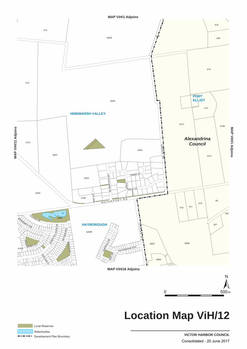
A12
Q406
Q405
A101
Q200
Q201
A21
A403
Q907
A101
A10
A20
A500
A158
A22
A30
A100
A6
A10
A12
A906
Q905
A404
A18
A100
A2000
A10
A11
A131
A13
TRADE CT
MIS
SE
N AV
DR
UM
MOND CCT
SPRINGBETT DR
AGN
ES G
ILLE
SP
IE D
R
SINCLAIR ST
EMER
ALD
DR
KLEINIG DR
LINC
OLN
PAR
K D
R
AQUAMARINE BVD
PIT
L AN
E
CO
MM
E RCE CR
MIN
T D
R
HE
YSE
N P
DE
OC
EA
N R
D
W A T E R P O R T R D
AlexandrinaCouncil
HINDMARSH VALLEY
PORTELLIOT
HAYBOROUGH
VICTOR HARBOR COUNCIL
Location Map ViH/12
0 500m
Local Reserves
Waterbodies
Development Plan Boundary
MAP ViH/1 AdjoinsM
AP ViH
/1 Adjoins
MAP ViH/16 Adjoins
MA
P Vi
H/1
1 A
djoi
ns
LINC
OLN
RD
Consolidated - 20 June 2017
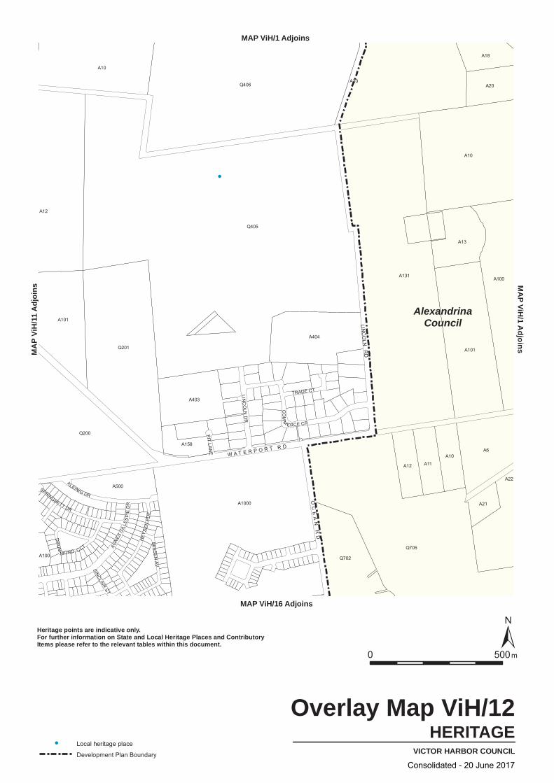
A12
A10
Q406
A22
A10
Q201
A30
A101
A404
A13
A101
A1000
Q405
A100
A18
A6
A403
A11
A20
Q705
A500
A158
Q702
A131
A10
A21
A100
Q200
A12
SPRINGBETT DR
AGN
ESG
ILLE
SP
IED
R
SINCLAIRST
KLEINIG DR
LINC
OLN
DR
PIT
L AN
E
CO
MM
E RCE CR
HE
YSE
NP
DE
TRADE CT
MIS
SE
NAV
DR
UM
MOND CCT
OC
EA
NR
D
W A T E R P O R T R D
AlexandrinaCouncil
HERITAGEVICTOR HARBOR COUNCIL
Overlay Map ViH/12
0050 m
Local heritage place
Development Plan Boundary
Heritage points are indicative only.For further information on State and Local Heritage Places and ContributoryItems please refer to the relevant tables within this document.
MAP ViH/1 AdjoinsM
AP
VHi
/d
A 1
ji o
sn
MAP ViH/16 Adjoins
sniojdA 11/
HiV PA
M
LINC
OLN
RD
Consolidated - 20 June 2017

LIn
R
PrPro(MLR)
A6
Q200
Q201
A21
A403
Q907
A12
A10
A20
A500
A158
A22
A30
A100
A101
A10
A12
A906
Q905
A404
A18
A100
A2000
A10
A11
A131
A13
Q406
Q405
A101
DR
UM
MOND CCT
SPRINGBETT DR
AGN
ES G
ILLE
SP
IE D
R
SINCLAIR ST
EMER
ALD
DR
KLEINIG DR
LINC
OLN
PAR
K D
R
AQUAMARINE BVD
PIT
L AN
E
CO
MM
E RCE CR
MIN
T D
R
HE
YSE
N P
DE
TRADE CT
MIS
SE
N AV
OC
EA
N R
D
W A T E R P O R T R D
AlexandrinaCouncil
VICTOR HARBOR COUNCIL
Zone Map ViH/12
0 500m
Lamberts Conformal Conic Projection, GDA94
ZonesLight IndustryLIn
Primary Production (Mount Lofty Ranges)PrPro(MLR)
ResidentialR
Zone Boundary
Development Plan Boundary
MAP ViH/1 AdjoinsMAP ViH/1 Adjoins
MAP ViH/16 Adjoins
MAP V
iH/11
Adjo
ins
Consolidated - 20 June 2017
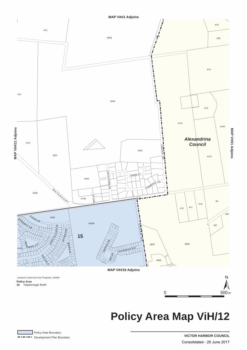
A18
A13
A158
Q200
A906
A12
A12
Q907
A30
A101
A100
Q201
A10
A6
A404
A10
A101
A11
A403
Q405
A131
A10
A22
Q905
A20
A100
A500
A2000
Q406
A21
MIS
SE
N AV
DR
UM
MOND CCT
SPRINGBETT DR
AGNE
S G
ILLE
SP
IE D
R
SINCLAIR ST
EMER
ALD
DR
KLEINIG DR
LINC
OLN
PAR
K D
R
AQUAMARINE BVD
PIT
LAN
E
COMMERCE CR
MIN
T D
R
HEY
SE
N P
DE
TRADE CT
O
LINC
OLN
RD
CE
AN
RD
WA T E
RP
OR T
R D
AlexandrinaCouncil
15
VICTOR HARBOR COUNCIL
Policy Area Map ViH/12
0 500m
Lamberts Conformal Conic Projection, GDA94
Policy Area Boundary
Development Plan Boundary
Policy Area15 Hayborough North
MAP ViH/1 AdjoinsM
AP ViH
/1 Adjoins
MAP ViH/16 Adjoins
MA
P Vi
H/1
1 A
djoi
ns
Consolidated - 20 June 2017

LOWER INMAN VALLEY
BACK VALLEY
VICTOR HARBOR
WAITPINGAJASMIN DR
WATER RESERVE R
D
A2
A1
A50
A51A30
S656
Q52
A662
A96
A4
Q50
A45
A5
A18
A6
A7
S453
S487
A10
A41
S729
A104
A17
A22
A21
A3
A24
A19
A60
A23
A20
A28
A26
A703
A101
A702
A27
S731
A29
A16
A100
A503
A84
S663
S662
A61
A201
A102
A701
A700
A78
A202
A200
A103
A501
A15
A36
A11
A203
A14
S490
A12
A502A37
VICTOR HARBOR COUNCIL
Location Map ViH/13
0 500 m
Local Reserves
MA
P Vi
H/1
Adj
oins
MAP ViH/9 Adjoins
MAP ViH/18 Adjoins
MA
P ViH/14 A
djoins
SW
AI N
CR
OS
SI N
G
R D C E M E T E R Y R D
PA
GE
R D
S T O C K R D
I N M A N
VA
LL
EY
RD
C L Y D
ES
DA
LE
DR
Consolidated - 20 June 2017
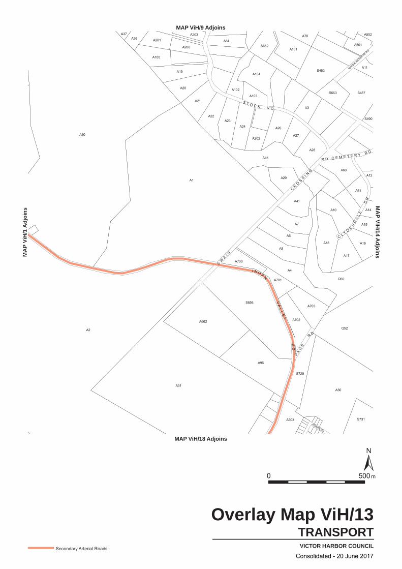
JASMIN DR
WATER RESERVE R
D
A2
A1
A50
A51A30
S656
Q52
A662
A96
A4
Q50
A45
A5
A18
A6
A7
S453
S487
A10
A41
S729
A104
A17
A22
A21
A3
A24
A19
A60
A23
A20
A28
A26
A703
A101
A702
A27
S731
A29
A16
A100
A503
A84
S663
S662
A61
A201
A102
A701
A700
A78
A202
A200
A103
A501
A15
A36
A11
A203
A14
S490
A12
A502A37
TRANSPORTVICTOR HARBOR COUNCIL
Overlay Map ViH/13
0 500 m
Secondary Arterial Roads
MA
P Vi
H/1
Adj
oins
MAP ViH/9 Adjoins
MAP ViH/18 Adjoins
MA
P ViH/14 A
djoins
SW
AI N
CR
OS
SI N
G
R D C E M E T E R Y R D
PA
GE
R D
S T O C K R D
I N M A N
VA
LL
EY
RD
C L Y D
ES
DA
LE
DR
Consolidated - 20 June 2017
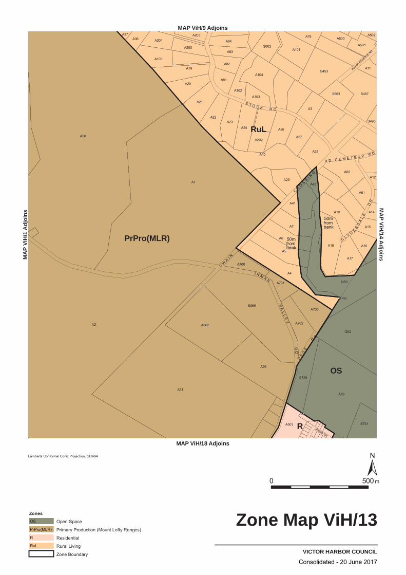
RuL
PrPro(MLR)
OS
R JASMIN DR
WATER RESERVE R
D
A2
A1
A50
A51A30
S656
Q52
A662
A96
A4
Q50
A45
A5
A18
A6
A7
S453
S487
A10
A41
S729
A104
A17
A22
A21
A3
A24
A19
A60
A23
A20
A28
A26
A703
A101
A702
A27
S731
A29
A16
A100
A503
A84
S663
S662
A61
A102
A201
A82
A81
A83
A701
A40
A700
A202
A200
A78
A103
A501
A15
A36 A500
A11
A203
A14
S490
A12
A502A37
180
VICTOR HARBOR COUNCIL
Zone Map ViH/13
0 500 m
MA
P Vi
H/1
Adj
oins
MAP ViH/9 Adjoins
MAP ViH/18 Adjoins
MA
P ViH/14 A
djoins
Lamberts Conformal Conic Projection, GDA94
Zones
Open SpaceOS
Primary Production (Mount Lofty Ranges)PrPro(MLR)
ResidentialR
Rural LivingRuL
Zone Boundary
50m from
bank
50mfrombank
SW
AI N
CR
OS
SI N
G
R D C E M E T E R Y R D
PA
GE
R D
S T O C K R D
I N M A N
VA
LL
EY
RD
C L Y D
ES
DA
LE
DR
0
Consolidated - 20 June 2017

27
5
29
29
2626
13 JASMIN DR
WATER RESERVE R
D
A2
A1
A50
A51A30
S656
Q52
A662
A96
A4
Q50
A45
A5
A18A6
A7
S453
S487
A10
A41
S729
A104
A17
A22
A21
A3
A24
A19
A60
A23
A20
A28
A26
A703
A101
A702
A27
S731
A29
A16
A100
A503
A84
S663
S662
A61
A102
A201
A82
A81
A83
A701
A40
A700
A202
A200
A78
A103
A501
A15
A36 A500
A11
A203
A14
S490
A12
A502A37
180o
VICTOR HARBOR COUNCIL
Policy Area Map ViH/13
0 500 m
Lamberts Conformal Conic Projection, GDA94
Policy Area Boundary
Policy Area13262729 5
Encounter BayHillsCrozier HillRural Living NorthGolf Course
MA
P Vi
H/1
Adj
oins
MAP ViH/9 Adjoins
MAP ViH/18 Adjoins
MA
P ViH/14 A
djoins
180
50mfrombank
50mfrombank
0
SW
AI N
CR
OS
SI N
G
R D C E M E T E R Y R D
PA
GE
R D
S T O C K R D
I N M A N
VA
LL
EY
RD
C L Y D
ES
DA
LE
DR
Consolidated - 20 June 2017
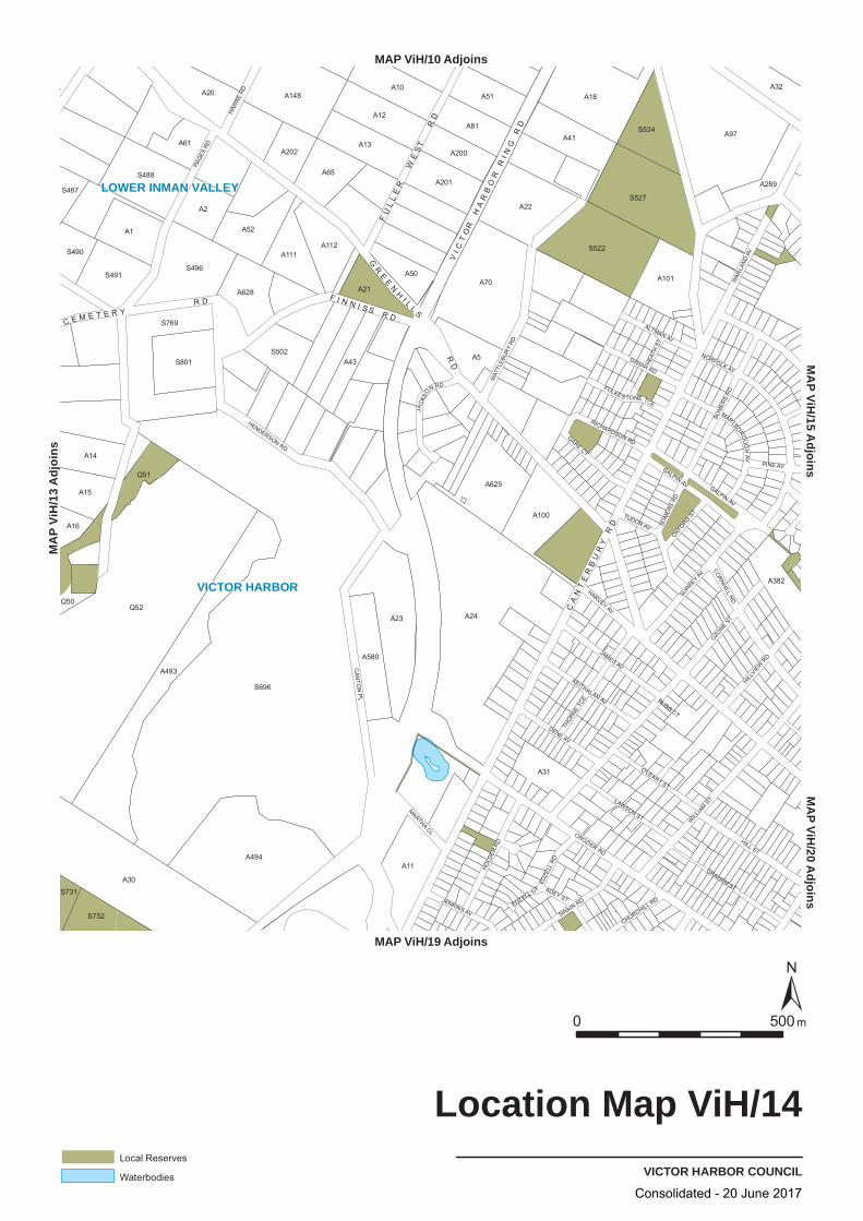
VICTOR HARBOR
LOWER INMAN VALLEY
OZONE
ST
CROZIER RD
PAG
ES R
D
CAN
TON
PL
WILL
IAM S
T
HENDERSON RD
HILL ST
NORFOLK AV
SURREY AV
WAT
TLEB
URY
RD
SOM
ERS
RD
GALPIN AV
JAMES AV
GRAHAM ST
CORNHILL
RD
WAR
LAND
AV
DENE AV
HOLD
ER R
D
SWAIN RD
TUDOR AV
GARE CT
THORN
E TC
E
O'LEARY ST
LAWSON ST
DWIAR RD
HILLVIE
WRD
KEITHALAN AV
ALTMAN AV
HAW
KERD
PINE AV
JENKINS AV
JACK
SO
N RD
MARTHA CL
MARLBOROUG
HAV
EDZE
LLRD
OXFORD
ST
RICHARDSON RD
FOLKES TONE TCE
ADEY ST
HARVEY AV
CHURCHILL RD
HEAT
H ST
EDZELL CT
BLISS CT
GALPIN AV
SOM
ERS
RD
S696
Q52A24
A30
A97
A494
A493
A70
A23
A18
S527
S522
S769
A22
A1
A148
A11
S496
A625
A2
S488
A41A13
A12
A100
A52
A5S801
A10
A65
A20
A101
A51
A580
A81
S491
S534
A14
A111A112
A628
A15
A31
A201
A382
A21
A32
A43
A50
S502
A61
Q51
A200
A289
S732
A202
Q50
S490
A16
S487
S731
VICTOR HARBOR COUNCIL
Location Map ViH/14
0050 m
Local Reserves
Waterbodies
MAP ViH/10 Adjoins
MAP ViH/19 Adjoins
sniojdA 31/
HiV PA
MA
MP
i V/
H1
A 5
j doinsA
MP
i VH2/0
dA
ji ons
CA
NT
ER
BU
RY
RD
GR
EE
NH
I L LS
RD
F I N N I S S R D
VI C
T
T
OH
AR
BO
R
R
RI N
GR
D
FU
LL
ER
WE
SR
D
C E M E T E R YR D
Consolidated - 20 June 2017

S730
Q6
A11
A50
A14
A1
S488
S485
A20
A112
A22
A101
S534
A289
A382
A31
A31
S487
S491
A32
A12
A5
A81
A70
S527
S696
A31
S769
A93
A13
A10
A11
A41
S731
A493
A101
A22
A24
S490
A11
A628
A201
A202
A580
A50
A62
A101
A101
S522
A32
A20
Q4
A15
A13
A2
A111
A148
A61
A201
A42
A111
S732
A16
A19
A19
A43
A200
A51
A21
A494
A10
A2
S502
A152
A65
A210
A23
A18
A101
A12
A22
S496
A1
A52
A21
A100
A101
A97
SWAIN
RD
WILL
IAM
ST
PINE AV
SURREY AV
GALPIN AV
TUD
OR
AV
OZONE ST
CROZIER RD
HILL ST
THO
RNE TC
E
O'LEARY ST
HILLV
IEW
RD
JENKINS AV
HEAT
H ST
HENDERSON RD
DWIAR RD
ALTMAN AV
ADEY ST
FOLKES TONE TCE SOM
ERS
RD
HOLD
ER R
D
CORNH
ILL RD
DENE AV
HARVEY AV
KEITHALAN AV
JAMES AV
CHURCHILL RD
EDZE
LL RD
OXFORD
ST
MARTHA CL
HAW
KE R
D
PAG
ES
RD
LAWSON ST
GRAHAM ST
RICHARDSON RD
WAT
TLE
BU
RY
RD
NO
RFO
LK AV
MARLBOROUG
H AV
WAR
LAN
D AV
GARE CT
JAC
KSO
N
RD
CA
NTO
N P
L
WA
GG
ON
R D
GR
EE
NH
I L LS
RD
C E M E T E RY R
D
F I N N I S S R D
SE
A VI E
W R
D
A R
MS
TR
ON
G R
DF
UL
LE
R W
ES
T R
D
DA
Y R
D
CA
NT
ER
BU
RY
RD
VI C
TO
R H
AR
BO
R R
I NG
RD
HERITAGEVICTOR HARBOR COUNCIL
Overlay Map ViH/14
0 500m
Local heritage place
Heritage points are indicative only.For further information on State and Local Heritage Places and ContributoryItems please refer to the relevant tables within this document.
MAP ViH/10 Adjoins
MAP ViH/19 Adjoins
MAP V
iH/13
Adjo
insMAP ViH/15 Adjoins
MAP ViH/20 Adjoins
Consolidated - 20 June 2017

R
RuL
OS
OS
LIn
MU RCe
OZONE
ST
CROZIER RD
PAG
ES R
D
CAN
TON
PL
WILL
IAM
ST
HEN
DE
RS
ON
RD
HILL ST
NORFOLK AV
SURREYAV
WAT
TLEB
URY
RD
SOM
ERS
RD
GALPIN AV
JAMES AV
GRAHAM ST
CORNHILL RD
WAR
LAND
AV
DENE AV
HOLD
ERRD
SWAINRD
TUDOR AV
GARE CT
THORN
ETC
E
O'LEARY ST
LAWSON ST
DWIAR RD
HILLVIE
WRD
KEITHALAN AV
ALTMAN AV
HAW
KERD
PINE AV
JENKINS AV
JACK
SO
N RD
MARTHA CL
MARLBOROUG
HAV
EDZE
LLRD
OXFORD
ST
RICHARDSON RD
FOLKES TONE TCE
ADEY ST
HARVEY AV
CHURCHILL RD
HEAT
HST
EDZELL CT
BLISS CT
GALPIN AV
SOM
ERS
RD
WARLANDAV
S696
Q52A24
A30
A97
A494
A493
A70
A23
A18
S527
S522
S769
A22
A1
A148
A11
S496
A625
A2
S488
A41A13
A12
A100
A52
A5S801
A10
A65
A20
A101
A51
A580
A81
S491
S534
A14
A111A112
A628
A15
A31
A201
A382
A21
A32
A43
A50
S502
A61
Q51
A200
A289
S732
A202
Q50
S490
A16
S487
S731
180o
VICTOR HARBOR COUNCIL
Zone Map ViH/14
0050 m
Lamberts Conformal Conic Projection, GDA94
Zones
Light IndustryLIn
Mixed UseMU
Open SpaceOS
Regional CentreRCe
ResidentialR
Rural LivingRuL
Zone Boundary
MAP ViH/10 Adjoins
MAP ViH/19 Adjoins
sniojdA 31/
HiV PA
MM
AP
Vi1/
H5
j dA
oisn
M P
AViH
/20A
dji o
sn
A32
CA
NT
ER
BU
RY
RD
GR
E ENH
I LL
S
AR
MS
TR
ON
GR
D
F I N N I S S R D
FU
LL
ER
WE
ST
RD
WA
GG
ON
R D
S W A I N SC R O S S I N G R D
DA
YR
D
C R OZ
I E
RR D
Consolidated - 20 June 2017
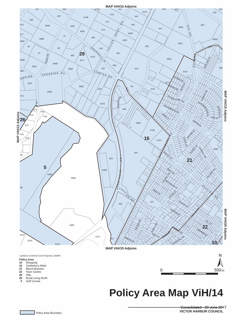
081o
A101
A23
A70
A625
A41
A101
S527
A11
A10
A20
A493
S502A101
A101
A289
A382
S490
A50
A12
S496
A2
A1
A202
A62
A51
A111
A16
A22
A1
S488
S769
A494
A10
A11
A200
A22
A15
A13
Q6
A32
A43
A210
A50
A11
A201
A20
S731
25A13A
A65
A580
A12
A22
A100
S522
A2
S696
A628
A111
A148
A13
A61
A5
A81
A101
A24
A21A18
S534
A101
A14
A14
A19
A19
S732
A201
A52 A112
A152
A21
A31
A97
A32A31
S487
Q4
S491
S485
S730
GRAHAMST
NO
RFO
LKAV
MARLBOROUG
HAV
WAR
LAN
DAV
SWAIN
RD
WILL
IAM
ST
ALTMAN AV
GARECT PINE AV
SURREYAV
GALPIN AV
TUD
OR
AV
OZONEST
JAC
KSO
NRD
CROZIER RD
HILL ST
RICHARDSON RD
THO
RNETC
E
O'LEARY STHIL
LVIE
WRD
JENKINS AV
HEAT
H STDWIAR RD
ADEY ST
FOLKES TONE TCE SOM
ERS
RD
HOLD
ERR
D
CORNH
ILLRD
DENE AV
HARVEY AV
KEITHALAN AV
JAMES AV
CHURCHILL RD
EDZE
LLRD
OXFORD
ST
PAG
ES
RD
LAWSON ST
GR
E ENH
I LL
S
RD
AR
MS
TR
ON
GR
D
F I N N I S S R D
CA
NT
ER
BU
RY
RD
C R OZ
I E
RR D
FU
LL
ER
WE
ST
RD
WA
GG
ON
R D
DA
YR
D
S W A I N SC R O S S I N G R D
SE
A VI E
WR
D
21
16
5
22
10
26
29
VICTOR HARBOR COUNCIL
Policy Area Map ViH/14
0050 m
Lamberts Conformal Conic Projection, GDA94
Policy Area Boundary
Policy Area101621222629 5
ShoppingCanterbury WestMount BreckanTown CentreHillsRural Living NorthGolf Course
MAP ViH/10 Adjoins
MAP ViH/19 Adjoins
sniojdA 31/
HiV PA
MM
/Hi
V P
A1
A 5
sni o
j dM
HiV
PA
2/0d
A oj
sni
Consolidated - 20 June 2017
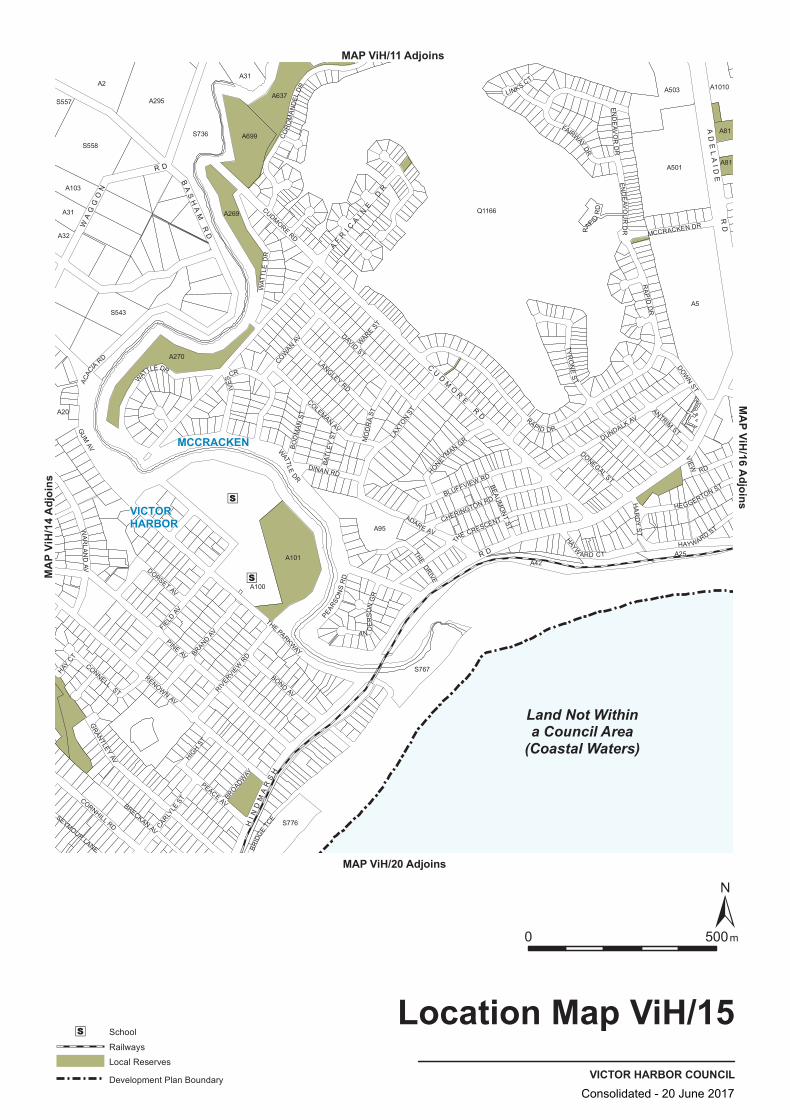
S558
A295
A31
A101
A637
A31
A270
A42
A2
A699
A100
S557
A501
A32
A20
Q1166
S736
S767
A503 A1010
A269
A95
A5
A81
A81
A103
A25
S776
S543
IVES
CR
BRID
GE
TCE
CORNHILL RD CARLYLE
ST
CONNELL ST
HA
RD
Y S
T
RENOWN AV
HONEYMAN GR
LINKS CT
ADARE AV
COWAN
AV
COLEMAN AV
ANTRIM ST
DONEGAL ST
WAT
TLE
DR
PEACE AV
GUM
AV
BEAU
MO
NT
ST
THE DRIVE
HAY CT
CUDMORE RD
AN
DE
RS
ON
GR
MO
DR
A S T
PINE AV
DINAN RD
BRECKAN AV
BLUFFVIEW RD
DAVID ST
DOWN ST
TYR
ON
E S
T
THE CRESCENT
WARE
ST
FIELD
AV
RIVERVIE
W RD
RAPID
RD
THE PARKWAYBRAND
AV
DUNDALK AV
HIGH
ST
BROADWAY
BATL
EY
ST
HEGGERTON ST
EN
DE
AVO
R D
R
CHERINGTON RD
SEYMOUR LANE
DORSET AV
VIEW
RD
GRANTLEY
AV
BO
DM
AN
ST
PEARSO
NS
RD
EN
DEA V
OU
R D
R
HAYW
ARD CTHAYWARD ST
BOND AV
MCCRACKEN DR
ACAC
IA RD LANGLEY
RD
W
ATTLE DR
WATTLE
DR
FAIRWAY DR
LAXT
ON
ST
CO
RO
MA
ND
EL
DR
RAPID DR
RA
PID
DR
WA
RLA
ND
AV
AF
RI C
AI N
E D
R
HI N
DM
AR
SH
R D
CU
DM
OR
E R
D
WA
GG
ON
R D
AD
EL
AID
E R
D
BA
SH
AM
RD
Land Not Withina Council Area
(Coastal Waters)
MCCRACKEN
VICTORHARBOR
VICTOR HARBOR COUNCIL
Location Map ViH/15
0 500m
School
Railways
Local Reserves
Development Plan Boundary
MAP ViH/11 Adjoins
MAP ViH/20 Adjoins
MAP V
iH/14
Adjo
insMAP ViH/16 Adjoins
Consolidated - 20 June 2017

A1010
A31
A270
A42
A2
A699
A100
S557
A501
A32
A20
S558
S736
S767
A503
Q1166A269
A95
A5
A81
A81
A103
A25
S776
S543
A295
A31
A101
A637
CARLYLE
STCORNHILL RD
CONNELL ST
HA
RD
Y S
T
RENOWN AV
HONEYMAN GR
LINKS CT
ADARE AV
COWAN
AV
COLEMAN AV
ANTRIM ST
DONEGAL ST
WAT
TLE
DR
PEACE AV
GUM
AV
BEAU
MO
NT
ST
THE DRIVE
HAY CT
CUDMORE RD
AN
DE
RS
ON
GR
MO
DR
A S T
PINE AV
DINAN RD
BRECKAN AV
BLUFFVIEW RD
DAVID ST
DOWN ST
TYR
ON
E S
T
THE CRESCENT
WARE
ST
FIELD
AV
RIVERVIE
W RD
RAPID
RD
THE PARKWAYBRAND
AV
DUNDALK AV
HIGH
ST
BROADWAY
BATL
EY
ST
HEGGERTON ST
EN
DE
AVO
R D
R
CHERINGTON RD
SEYMOUR LANE
DORSET AV
VIEW
RD
GRANTLEY
AV
BO
DM
AN
ST
PEARSO
NS
RD
EN
DEA V
OU
R D
R
HAYW
ARD CTHAYWARD ST
BOND AV
MCCRACKEN DR
ACAC
IA RD LANGLEY
RD
W
ATTLE DR
WATTLE
DR
FAIRWAY DR
LAXT
ON
ST
CO
RO
MA
ND
EL
DR
RAPID DR
RA
PID
DR
WA
RLA
ND
AV
IVES
CR
BRID
GE
TCE
AF
RI C
AI N
E D
R
HI N
DM
AR
SH
R D
CU
DM
OR
E R
D
WA
GG
ON
R D
AD
EL
AID
E R
D
BA
SH
AM
RD
Land Not Withina Council Area
(Coastal Waters)
TRANSPORTVICTOR HARBOR COUNCIL
Overlay Map ViH/15
0 500m
Primary Arterial Roads
Development Plan Boundary
MAP ViH/11 Adjoins
MAP ViH/20 Adjoins
MAP V
iH/14
Adjo
insMAP ViH/16 Adjoins
Consolidated - 20 June 2017
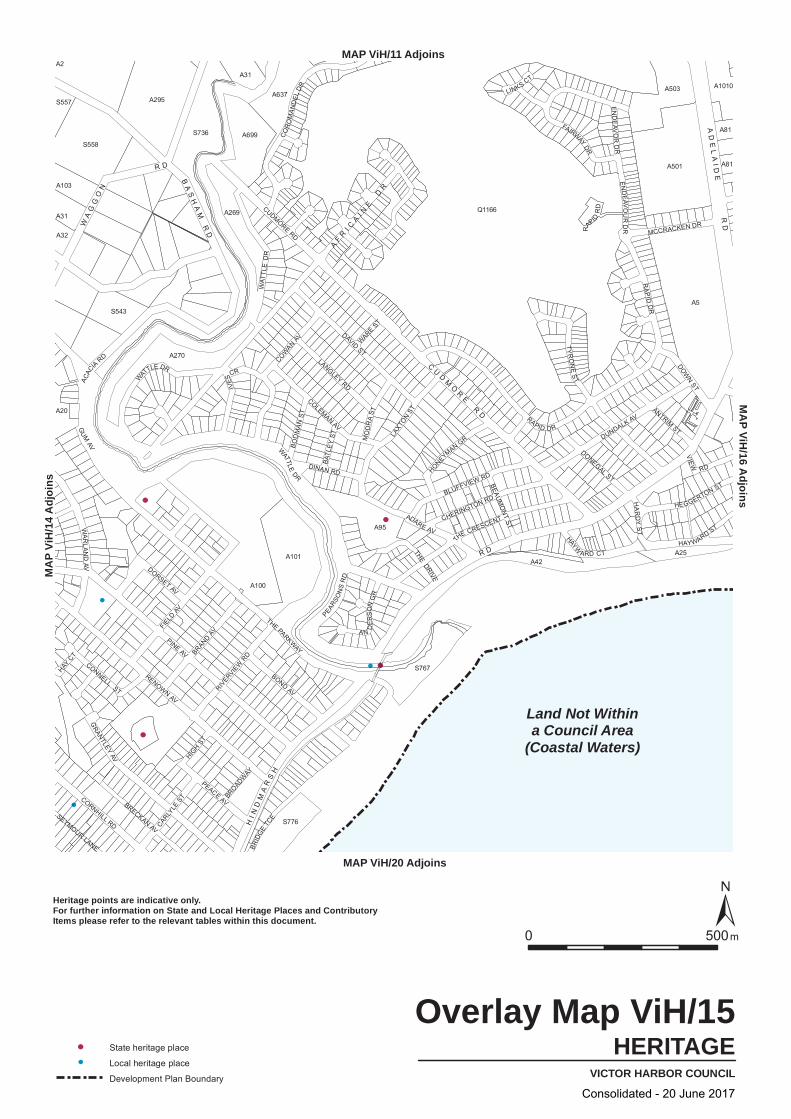
A1010
A31
A270
A42
A2
A699
A100
S557
A501
A32
A20
S558
S736
S767
A503
Q1166A269
A95
A5
A81
A81
A103
A25
S776
S543
A295
A31
A101
A637
CARLYLE
STCORNHILL RD
CONNELL ST
HA
RD
Y S
T
RENOWN AV
HONEYMAN GR
LINKS CT
ADARE AV
COWAN
AV
COLEMAN AV
ANTRIM ST
DONEGAL ST
WAT
TLE
DR
PEACE AV
GUM
AV
BEAU
MO
NT
ST
THE DRIVE
HAY CT
CUDMORE RD
AN
DE
RS
ON
GR
MO
DR
A S T
PINE AV
DINAN RD
BRECKAN AV
BLUFFVIEW RD
DAVID ST
DOWN ST
TYR
ON
E S
T
THE CRESCENT
WARE
ST
FIELD
AV
RIVERVIE
W RD
RAPID
RD
THE PARKWAYBRAND
AV
DUNDALK AV
HIGH
ST
BROADWAY
BATL
EY
ST
HEGGERTON ST
EN
DE
AVO
R D
R
CHERINGTON RD
SEYMOUR LANE
DORSET AV
VIEW
RD
GRANTLEY
AV
BO
DM
AN
ST
PEARSO
NS
RD
EN
DEA V
OU
R D
R
HAYW
ARD CTHAYWARD ST
BOND AV
MCCRACKEN DR
ACAC
IA RD LANGLEY
RD
W
ATTLE DR
WATTLE
DR
FAIRWAY DR
LAXT
ON
ST
CO
RO
MA
ND
EL
DR
RAPID DR
RA
PID
DR
WA
RLA
ND
AV
IVES
CR
BRID
GE
TCE
AF
RI C
AI N
E D
R
HI N
DM
AR
SH
R D
CU
DM
OR
E R
D
WA
GG
ON
R D
AD
EL
AID
E R
D
BA
SH
AM
RD
Land Not Withina Council Area
(Coastal Waters)
HERITAGEVICTOR HARBOR COUNCIL
Overlay Map ViH/15
0 500m
State heritage place
Local heritage place
Development Plan Boundary
Heritage points are indicative only.For further information on State and Local Heritage Places and ContributoryItems please refer to the relevant tables within this document.
MAP ViH/11 Adjoins
MAP ViH/20 Adjoins
MA
P Vi
H/1
4 A
djoi
nsM
AP ViH
/16 Adjoins
Consolidated - 20 June 2017

R
R
R
R
OS
RuL
CstOS
DU
NCe
C
C
CP
NCe
RCe
Land Not Within a Council Area (Coastal Waters)
PINE AV
GUM AV
RAPID
DR
RENOWN AV
THE PARKWAY
DAVIDST
TYRONE ST
FIELD
AV
DUNDALK AV
GRANTLEY AV
LAXT
ONST
CUDMORE RD
THE CRESCENT
ADARE AV
WATTLE
DR
BRAND AV
BOND AV
WAR
LAN
DAV
CO
RO
MAN
DEL
DR
ACACIA RD
BLUFFVIEW RD
PEACE AVCORNHILL RD
DOWN
ST
IVE
S C
R
RIVER
VIEW
RD
BRECKAN AV
LANGLEY RD
CHERINGTON RD
EN
DE
AV
OU
RD
R
CARLY
LEST
DINAN RD
ANTRIM ST
HAYWARD ST
FAIRWAY DR
DONEGAL ST
COWAN AV
VALLEY VIEW RD
MOD
RA S
T
CONNELL ST
THE DRIVE
HEGGER TON ST
HONEYMAN GR
H
AYWARD CT
COLEMAN AV
HIGH S
T
BOD
MAN
ST
VIEW RD
DORSET AV
HAR
DY
ST
PEARS
ON
SR
D
BEAUM
ON
TST
RAPID RD
WAREST
BROAD
WAY
SEYMOUR LANE
LINKS CT
HAY C
T
FERNBA
NK RD
EMMA CT
HOOGHLY CT
ANDERSON G R
SCHAHCT
GOSHAWK CT
ISABELLA CT
WATTLE DR
GUM
AV
CO LEMAN AV
WATTLE DR
IVES
CR
TAMO
'SH
ANTE
RPL
Q950
A5
A100
A501
S736
A2
A295
A101
S558
A42
A95
A270
A699
A503
S767
A702
S776
A269
S543
A25
A31
A103
A1010
A20
A32
S557
A81
77m
51m
32m
180o
90o
90 o
180o
180o
VICTOR HARBOR COUNCIL
Zone Map ViH/15
0050 m
Lamberts Conformal Conic Projection, GDA94
Zones
Caravan and Tourist ParkCP
Coastal Open SpaceCstOS
CommercialC
Deferred UrbanDU
Neighbourhood CentreNCe
Open SpaceOS
Regional CentreRCe
ResidentialR
Rural LivingRuL
Zone Boundary
Development Plan Boundary
MAP ViH/11 Adjoins
MAP ViH/20 Adjoins
sniojdA 41/
HiV PA
MM
AP
V1/
Hi6
j dA
oisn
HI N
DM
AR
SH
R D
CU
DM
OR
ER
D
WA
GG
ON
R D
AD
EL
AID
ER
D
BA
SH
AM
RD
Consolidated - 20 June 2017
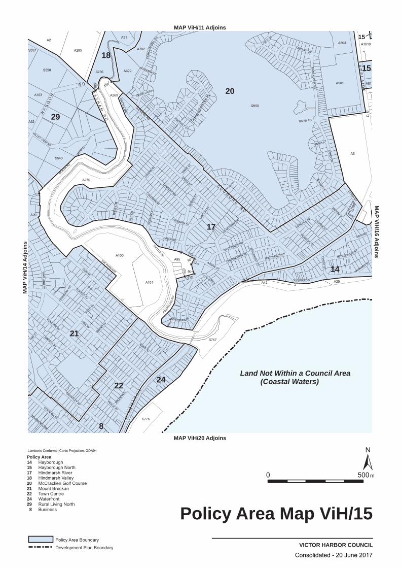
20
17
2
8
1
29
22
14
24
1815
15
Land Not Within a Council Area (Coastal Waters)
PINE AV
GUM AV
RAPID
DR
RENOWN AV
THE PARKWAY
DAVIDST
TYRONE ST
FIELD
AV
DUNDALK AV
GRANTLEY AV
LAXT
ONST
CUDMORE RD
THE CRESCENT
ADARE AV
WATTLE
DR
BRANDAV
BOND AV
WAR
LAN
DAV
CO
RO
MAN
DEL
DR
ACACIA RD
BLUFFVIEW RD
PEACE AVCORNHILL RD
DOWN ST
IVE
S C
R
LANGLEY RD
CHERINGTON RD
EN
DE
AV
OU
RD
R
DINAN RD
ANTRIM ST
HAYWARD ST
FAIRWAY DR
DONEGAL ST
COWAN AV
VALLEY VIEW RD
MOD
RA S
T
CONNELL ST
THE DRIVE
HEGGER TON ST
HONEYMAN GR
H
AYWARD CT
COLEMAN AV
BOD
MAN
ST
VIEW RD
DORSET AV
HAR
DY
ST
PEARS
ON
SR
D
BEAUM
ON
TST
RAPID RD
WAREST
BROAD
WAY
SEYMOUR LANE
LINKS CT
HAY C
T
FERNBA
NK RD
EMMA CT
HOOGHLY CT
ANDERSON G R
SCHAHCT
GOSHAWK CT
ISABELLA CT
WATTLE DR
GUM
AV
CO LEMAN AV
IVES
CR
TAMO
'SH
ANTE
RPL
Q950
A5
A100
A501
S736
A2
A295
A101
S558
A42
A95
A270
A699
A503
S767
A702
S776
A269
S543
A25
A31
A103
A1010
A20
A32
S557
A81
77m
180o
180o
51m
32m90o
90 o
180o
VICTOR HARBOR COUNCIL
Policy Area Map ViH/15
0050 m
Lamberts Conformal Conic Projection, GDA94
Policy Area Boundary
Development Plan Boundary
Policy Area141517182021222429 8
HayboroughHayborough NorthHindmarsh RiverHindmarsh ValleyMcCracken Golf CourseMount BreckanTown CentreWaterfrontRural Living NorthBusiness
MAP ViH/11 Adjoins
MAP ViH/20 Adjoins
sniojdA 41/
HiV PA
MM
AP
V1/
Hi6
j dA
oisn
HI N
DM
AR
SH
R D
CU
DM
OR
ER
D
WA
GG
ON
R D
AD
EL
AID
ER
D
BA
SH
AM
RD
Consolidated - 20 June 2017
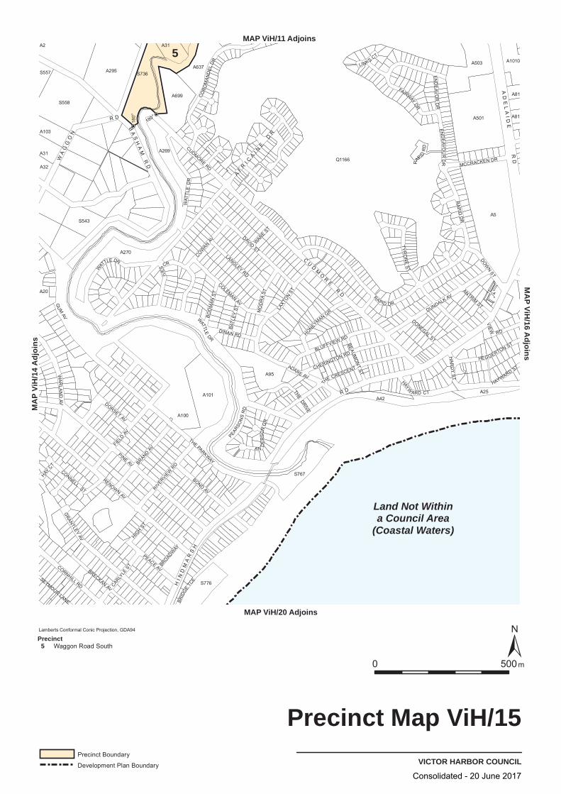
180o
180o
S558
A31
A100
S767
A501
A1010
A2
S543
A270
S776
A637
A103
A295
A20
A269
A699
A101
A95
A503
A42
A5
A25
A32
A31
S736
Q1166
A81
A81
S557
BRID
GE
TCE
CORNHILL RD CARLYLE
ST
CONNELL ST
HA
RD
Y S
T
RENOWN AV
HONEYMAN GR
LINKS CT
ADARE AV
COWAN
AV
COLEMAN AV
ANTRIM ST
DONEGAL ST
WAT
TLE
DR
PEACE AV
GUM
AV
BEAU
MO
NT
ST
THE DRIVE
HAY CT
CUDMORE RD
AN
DE
RS
ON
GR
MO
DR
A S T
PINE AV
DINAN RD
BRECKAN AV
BLUFFVIEW RD
DAVID ST
DOWN ST
TYR
ON
E S
T
THE CRESCENT
WARE
ST
FIELD
AV
RIVERVIE
W RD
RAPID
RD
THE PARKWAYBRAND
AV
DUNDALK AV
HIGH
ST
BROADWAY
BATL
EY
ST
HEGGERTON ST
EN
DE
AVO
R D
R
CHERINGTON RD
SEYMOUR LANE
DORSET AV
VIEW
RD
GRANTLEY
AV
BO
DM
AN
ST
PEARSO
NS
RD
EN
DEA V
OU
R D
R
HAYW
ARD CT
HAYWARD ST
BOND AV
MCCRACKEN DR
LANGLEY RD
W
ATTLE DR
WATTLE
DR
FAIRWAY DR
LAXT
ON
ST
CO
RO
MA
ND
EL
DR
RAPID DR
RA
PID
DR
WA
RLA
ND
AV
IVES
CR
AF
RI C
AI N
E D
R
HI N
DM
AR
SH
R D
CU
DM
OR
E R
D
WA
GG
ON
R D
AD
EL
AID
E R
D
BA
SH
AM
RD
Land Not Withina Council Area
(Coastal Waters)
5
VICTOR HARBOR COUNCIL
Precinct Map ViH/15
0 500m
MAP ViH/11 Adjoins
MAP ViH/20 Adjoins
MA
P Vi
H/1
4 A
djoi
nsM
AP ViH
/16 Adjoins
Lamberts Conformal Conic Projection, GDA94
Precinct Boundary
Development Plan Boundary
Precinct 5 Waggon Road South
Consolidated - 20 June 2017
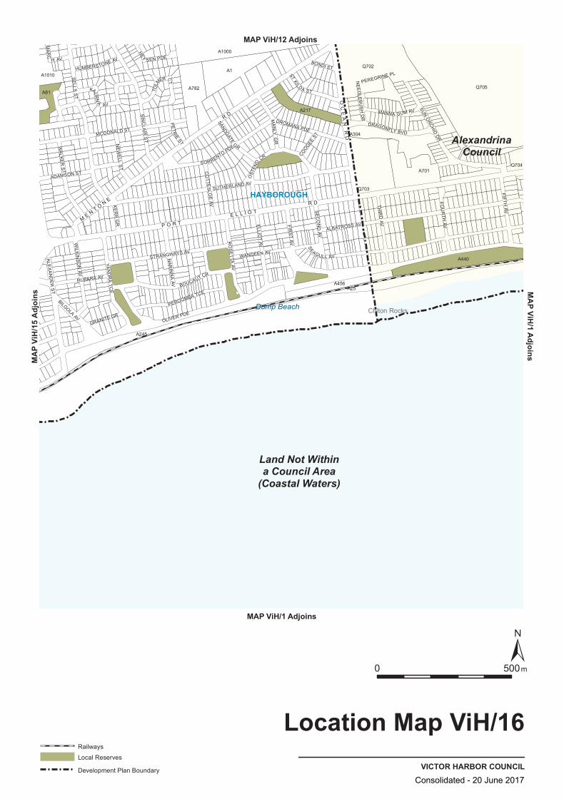
A81Q705
Q702
A304
A440
Q704
A25
A217
A782
Q703
A245
A1000
A1010
A456
A1
A701
OLIVER PDE
SIN
CLA
IR S
T
PE
TR
IE ST
HEY
SEN PDE
TOLM
ER CT
SEAGULL AV
SE
LLS S
T
SUN O
RCHID
DR
NE
ED
LEB
US
H D
R
SUTHERLAND AV
FIFTH AV
YAN
DR
A TC
E
WIL K
INS
ON
AV
F IRS
T AV
BOUCAUT CR
ALE
XA
ND
ER
ST
RO
SE
TTA AV
BILGOLA AV
RUPARA AV
SE
CO
ND
AV
MCDONALD ST
WANDEEN AV
ALBATROSS AV
DRAGONFLY BVD
NE
WE
LL S
T
OST
END
CR
STRANGWAYS AV
ADAMSON ST
FOU
RTH
AV
CO
TTES
LOE
AV
SANDGATE
GR
COOGEE
ST
THIR
D AV
KE
RR
GR
MA
NLY
GR
NA
RI N
NA
AV
BONDI ST
DROMANA PDE
ELLIOT AV
SORRENTO PDEWA
LKE
R S
T
MA
RC
H AV
GRANITE GR
PEREGRINE PLHUMBERSTONE AV
MANNA GUM AV
ST KILD A STKAU
RN
A AV
PEROOMBA TCE
OC
EA
N R
D
P O R T E L L I O T
R D
ME N T O
N E
R D
Land Not Withina Council Area
(Coastal Waters)
AlexandrinaCouncil
HAYBOROUGH
Chiton RocksDump Beach
VICTOR HARBOR COUNCIL
Location Map ViH/16
0 500m
Railways
Local Reserves
Development Plan Boundary
MAP ViH/1 Adjoins
MAP ViH/1 AdjoinsMAP ViH/12 Adjoins
MAP V
iH/15
Adjo
ins
Consolidated - 20 June 2017

Q702
A440
Q704
A25
A217
A782
Q703
A245
A1000
A1010
A456
A81
A701
Q705
A1
A304
SUN O
RCHID
DR
SIN
CLA
IR S
T
PE
TR
IE ST
HEY
SEN PDE
SEAGULL AV
SE
LLS S
T
TOLM
ER CT N
EE
DLE
BU
SH
DR
SUTHERLAND AV
FIFTH AV
YAN
DR
A TC
E
WIL K
INS
ON
AV
F IRS
T AV
BOUCAUT CR
ALE
XA
ND
ER
ST
RO
SE
TTA AV
BILGOLA AV
RUPARA AV
SE
CO
ND
AV
MCDONALD ST
WANDEEN AV
ALBATROSS AV
DRAGONFLY BVD
NE
WE
LL S
T
OST
END
CR
STRANGWAYS AV
ADAMSON ST
FOU
RTH
AV
CO
TTES
LOE
AV
SANDGATE
GR
COOGEE
ST
THIR
D AV
KE
RR
GR
MA
NLY
GR
NA
RI N
NA
AV
BONDI ST
DROMANA PDE
ELLIOT AV
SORRENTO PDEWA
LKE
R S
T
MA
RC
H AV
GRANITE GR
PEREGRINE PLHUMBERSTONE AV
MANNA GUM AV
ST KILD A STKAU
RN
A AV
PEROOMBA TCE
OLIVER PDE
OC
EA
N R
D
P O R T E L L I O T
R D
ME N T O
N E
R D
Land Not Withina Council Area
(Coastal Waters)
AlexandrinaCouncil
Chiton RocksDump Beach
TRANSPORTVICTOR HARBOR COUNCIL
Overlay Map ViH/16
0 500m
Primary Arterial Roads
Secondary Arterial Roads
Development Plan Boundary
MAP ViH/1 Adjoins
MAP ViH/1 AdjoinsMAP ViH/12 Adjoins
MAP V
iH/15
Adjo
ins
Consolidated - 20 June 2017
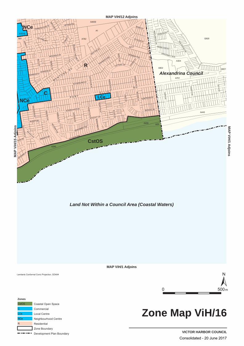
R
C
CstOS
NCe
LCeNCe
Land Not Within a Council Area (Coastal Waters)
Alexandrina Council
SELLS
ST
SEAGULL AV
SUTHERLAND AV
ALBATROSS AV
SUNORCHID
DR
SINCLAIR ST
MCDONALD ST
BOUCAUT CRFIR
ST AV
ELLIOT AV
STRANGWAYS AV
SO
MENTONE RD
RRENTO PDE
OLIVERS PDE
YAND
RA
TCE
FIFTHAV
RO
SETTA
AV
THIR
DAV
ALEXA
ND
ER
ST
RUPARA AV
OSTEND CR
PEROOMBA TCEM
AN
LY GR
WILK
INS
ON
AV
DROMANA PDE
NAR
INN
A AV
KAURNA AV
DRAGONFLY BVD
ST KILDA ST
FOU
RTH
AV
NEW
ELL
ST
ADAMSON ST
MANNA GUM AV
CO
TTES
LOE
AV
BILGOLA AV
SEC
ON
DAV
HEYSEN PDE
NEE
DLEB
US
HD
R
GRANITE GR
BONDI ST
PEREGRINE PLHUMBERSTONE AV
PET
RIEST
COOGEEST
T O LMER
CT
VIEW RD
MA
RG
ATE AV
PER
OO
MB
AP
L
HAYWARD ST
HIC
KSC
T
RAM
SG
ATE AV
RO
SET TA
PL
MILLEW
ATCE
WAN
ILLATC
E
ADAMSON ST
TOLM
ER
CT
Q920
A25
A1
A802
A245
A440
A701
A304
A782
A4000
A456
A217
A81
A1010
Q921
VICTOR HARBOR COUNCIL
Zone Map ViH/16
0050 m
Lamberts Conformal Conic Projection, GDA94
Zones
Coastal Open SpaceCstOS
CommercialC
Local CentreLCe
Neighbourhood CentreNCe
ResidentialR
Zone Boundary
Development Plan Boundary
MAP ViH/1 Adjoins
M P
AViH
1/d
Ani
ojs
MAP ViH/12 Adjoinssniojd
A 51/HiV P
AM
OC
EA
NR
DP O R T
E L L I O TR D
ME N T O N E
R D
Consolidated - 20 June 2017
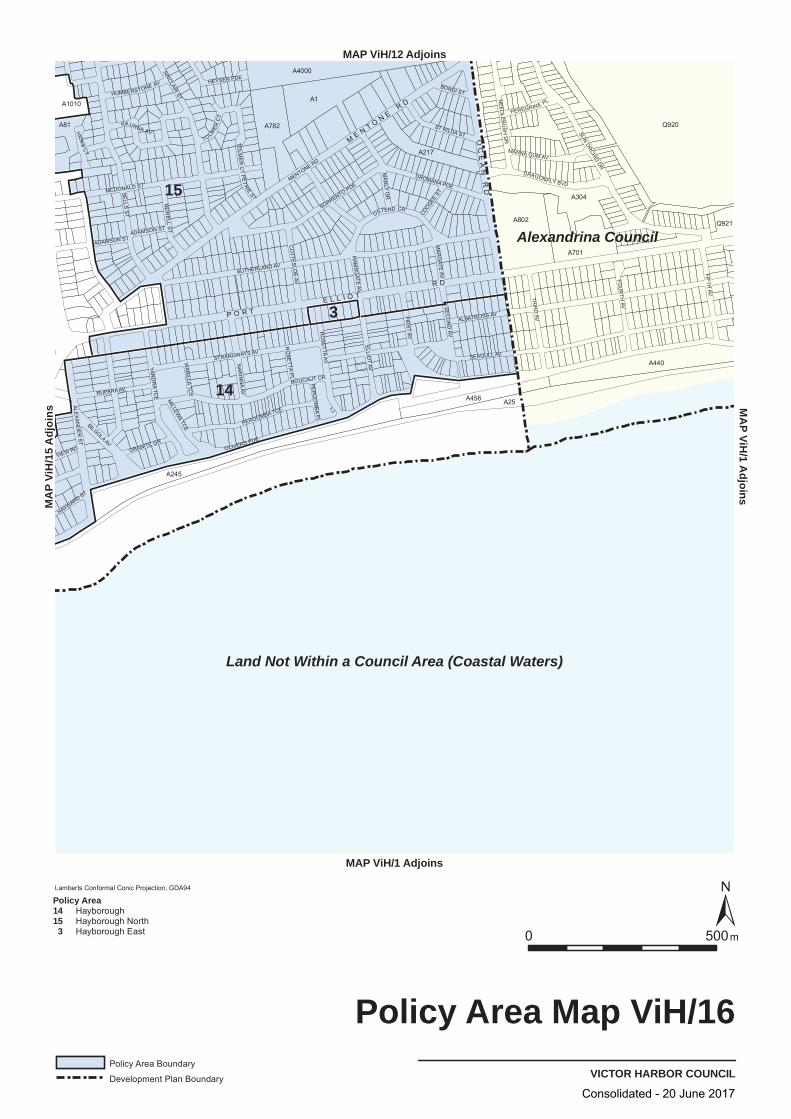
15
14
Land Not Within a Council Area (Coastal Waters)
Alexandrina Council
SELLS
ST
SEAGULL AV
SUTHERLAND AV
ALBATROSS AV
SUNORCHID
DR
SINCLAIR ST
MCDONALD ST
BOUCAUT CRFIR
ST
AV
ELLIOT AV
STRANGWAYS AV
SOR
MENTONE RD
RENTO PDE
OLIVERS PDE
YAND
RA
TCE
FIFTHAV
RO
SETTA
AV
THIR
DAV
ALEXA
ND
ER
ST
RUPARA AV
OSTEND CR
PEROOMBA TCEM
AN
LY GR
DROMANA PDE
NAR
INN
A AV
KAURNA AV
DRAGONFLY BVD
ST KILDA ST
FOU
RTH
AV
NEW
ELL
ST
ADAMSON ST
MANNA GUM AV
CO
TTES
LOE
AV
BILGOLA AV
SEC
ON
D AV
HEYSEN PDE
NEE
DLEB
US
HD
R
GRANITE GR
BONDI ST
PEREGRINE PLHUMBERSTONE AV
PET
RIEST
COOGEEST
T O LMER
CT
VIEW RD
MA
RG
ATE AV
PER
OO
MB
AP
L
HAYWARD ST
HIC
KSC
T
RAM
SG
ATE AV
RO
SET TA
PL
MILLEW
ATCE
WAN
ILLATC
E
ADAMSON ST
TOLM
ER
CT
Q920
A25
A1
A802
A245
A440
A701
A304
A782
A4000
A456
A217
A81
A1010
Q921
3
VICTOR HARBOR COUNCIL
Policy Area Map ViH/16
0050 m
Lamberts Conformal Conic Projection, GDA94
Policy Area Boundary
Development Plan Boundary
Policy Area1415 3
HayboroughHayborough NorthHayborough East
MAP ViH/1 Adjoins
M P
AViH
1/d
Ani
ojs
MAP ViH/12 Adjoinssniojd
A 51/HiV P
AM
OC
EA
NR
DP O R T
E L L I O TR D
ME N T O N E
R D
Consolidated - 20 June 2017

B9
A5
A16
A9A2
A1
A94
A32
A41
A8
S397
A31
A46
A3
A21
A27
A8
A34
S388S
A23
A24
A33
A4
A50
A44
A40
A45
A7
A25
A35
A22
A3
A47
S725
A29
A22
A18
A30
S739
A20
A28
A26
A2
A6
TUGWELL RD
GLA
STONB
URY DR
TJILBR
UK
E D
R
WAITPINGA
BACKVALLEY
VICTOR HARBOR COUNCIL
Location Map ViH/17
0 500m
MAP ViH/1 Adjoins
MAP ViH/1 Adjoins
MAP V
iH/1
Adjoi
nsMAP ViH/18 Adjoins
Consolidated - 20 June 2017

RuL
PrPro(MLR)
A44
A29
A16
A45
A9
A35
A94
A24
A47
A40
A23
A32
A25
A22
A46
A8
A22
A3
S739
A20
A21
A8
A31
A2
A6
B9
A26
A41
A30
A2
A34
S725
A1
A50
A5
A4
S388S
A18
A28
A7
A33
S397
A27
A3
GLA
SSEN
BURY
DR
TJILBR
UK
E D
R
T U GW
EL L
RD
VICTOR HARBOR COUNCIL
Zone Map ViH/17
0 500m
Lamberts Conformal Conic Projection, GDA94
ZonesPrimary Production (Mount Lofty Ranges)PrPro(MLR)
Rural LivingRuL
Zone Boundary
MAP ViH/1 Adjoins
MAP ViH/1 Adjoins
MAP V
iH/1
Adjoi
nsMAP ViH/18 Adjoins
Consolidated - 20 June 2017

A5
A3
A24
A28
A35
B9
A47
S388S
A29
A20
A30
A4
A32
A94
A46
S725
S397
A27
A26
A40
A44
A23
A22
A18
A21
A9A8
A2
A7
A3
A8
A1
A31
A34
A41
A16
A6
A50
S739A25
A22
A45
A2
A33
GLA
SSEN
BURY
DR
TJILBR
UK
E D
R
T
UG
WE
LL
R D
26
VICTOR HARBOR COUNCIL
Policy Area Map ViH/17
0 500m
Lamberts Conformal Conic Projection, GDA94
Policy Area Boundary
Policy Area26 Hills
MAP ViH/1 Adjoins
MAP ViH/1 Adjoins
MAP V
iH/1
Adjoi
nsMAP ViH/18 Adjoins
Consolidated - 20 June 2017
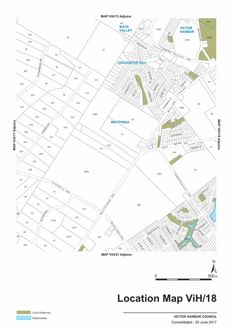
A46
A14
A1
A51
A308
A100
A7
A51
A2
A24
A47
A40
A50
S732
A32
A37
A649
A650
A22
A18
A19
A20
A9
A2
A3
A3
A16
A1
A5A21
A5
A6
A6
B9
A2
A17
A14
A3
S731
A41
A7A10
A13
A12
A34
A39
A1
A6
A16
A101
A10
S80
A8
A50
A1
A102 A40
A1
A503
A3000
A503
A100
A11
A5
A4
A36
A2
A23
A11
A33
A4
A5
A38
A101
A3
A6
A15
MANNIN
G AV
WIS
HAR T
CR
JEFFERY DR
TRIP
P ST
MARLIN TCE
CROSBY C T
HIGG
INS ST
ALLEN ST
BA
CC
HU
S R
D
VIC
TOR
AV
RYM
ILL
AV
POLTONG CR
ROBB
ST
MATTHEW FLINDERS DR
CUTTER CCT
LAURIE AV
SHIELDS CR
GLA
SS
EN
BU
RY
DR
SWEETMAN AV
PR
IME
BV
D
ZILM CT
JAS
MIN
DR
CLIVE AV
PERVAN
ST
KAY
CTSCAR
LETT
CT
CHAMBE
RS CT
DOLPHIN AV
BUTL
ER RI
SE
BAY RD
FERR
IER
DR
TA
BE
RN
AC
LE
RD
WA
I TP
I NG
A R
D
MI L
L R
D
WH
AL
ER
S R
D
T U G WE L L
R D
I N M A N V A L L E Y
R D
B A Y R D
ENCOUNTER BAY
WAITPINGA
VICTORHARBOR
BACKVALLEY
VICTOR HARBOR COUNCIL
Location Map ViH/18
0 500m
Local Reserves
Waterbodies
MAP ViH/13 Adjoins
MAP ViH/21 Adjoins
MAP V
iH/17
Adjo
insMAP ViH/19 Adjoins
Consolidated - 20 June 2017

FERR
IER
DR
BAY RD
PRIME BVD
BUTL
ER R
ISE
RYMILL AV
SWEETMAN AV
VICT
OR
AV
GLASSE
NB
UR
Y D
R
BAC
CH
US
RD
POLTONG CR
JASM
IN D
R
MA
RLI
N T
CE
ZILM CTLAURIE AV
HIGGINS ST
MAT
THEW
FLI
ND
ERS
DR
WIS
HART
CR
DOLPHIN AV
CUTTER CCT
SHIELDS CR
TRIP
P ST
ALLEN ST
KAY
CT
CHAMBE
RS CT
CLIVE AV
SCAR
LETT
CT
JEFFERY DR
PERVAN ST
MANN
ING AV
DYSON CT
CAM
ER
ON CT
BELM O NT ST
MU
RR
AY ST
CROSBY CT
ROBB STSIN
GH
CT
JONES W
AY
SAN
REM
O CT
S80
A2
A649
A1
A5
A503
A650
A301
A40
A100
A51
A7
A6
A8
A3
A14
A9
A4
A10
A16
S732
A23
A47
A101
A19
A18
A17
A21
A15
A39
A11
A36
A13
A38
A37
A50
A20
A12
A46
A102
A32
A41
A24
A33
A22
A3000
A34
A308
S731
B9
TRANSPORTVICTOR HARBOR COUNCIL
Overlay Map ViH/18
0 500 m
Secondary Arterial Roads
MAP ViH/13 Adjoins
MAP ViH/21 Adjoins
MA
P Vi
H/1
7 A
djoi
nsM
AP ViH
/19 Adjoins
TA
BE
RN
AC
LE
RD
WH
AL
ER
SR
D
T U G W E L R D
WA
I TP
I NG
RD
I N M A N V A L L E Y
R D
Consolidated - 20 June 2017
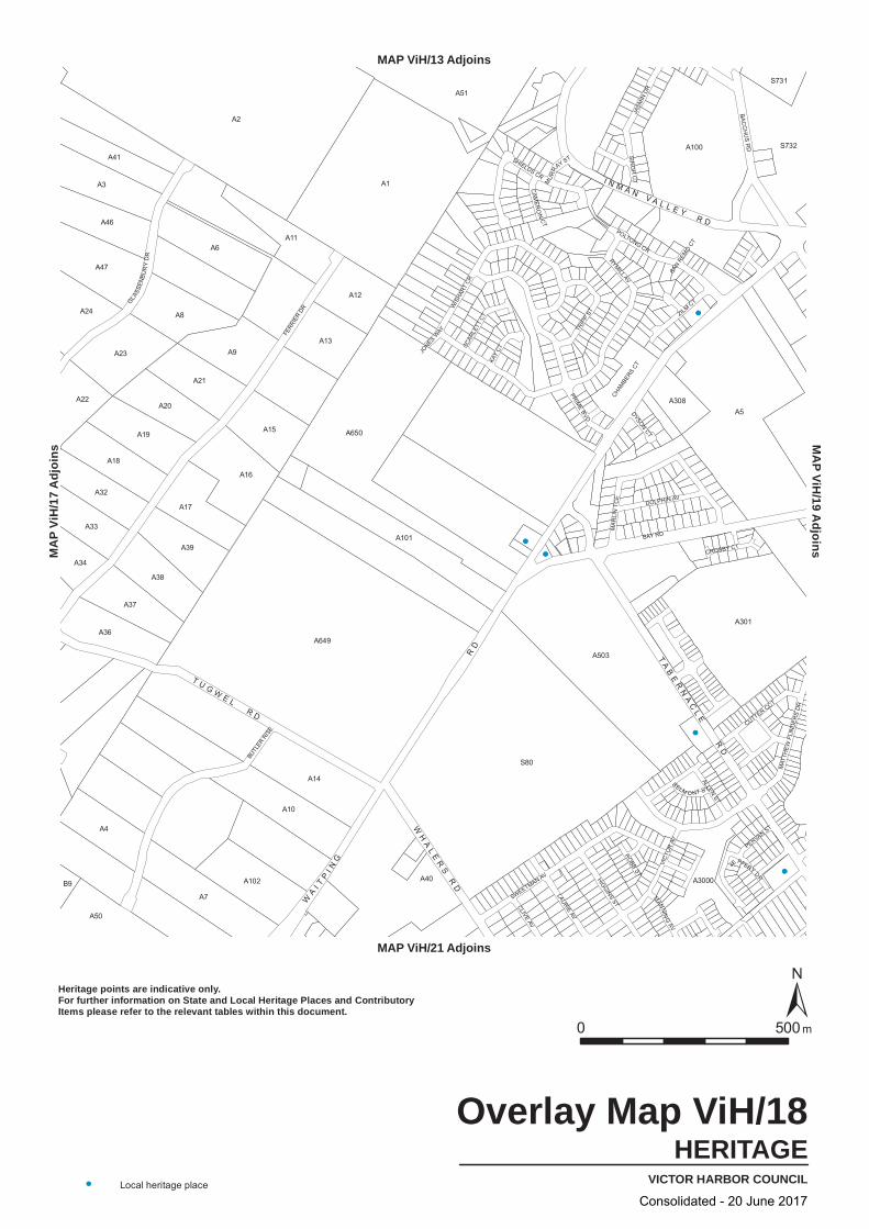
FERR
IER
DR
BAY RD
PRIME BVD
BUTL
ER R
ISE
RYMILL AV
SWEETMAN AV
VICT
OR
AV
GLASSE
NB
UR
Y D
R
BAC
CH
US
RD
POLTONG CR
JASM
IN D
R
MA
RLI
N T
CE
ZILM CTLAURIE AV
HIGGINS ST
MAT
THEW
FLI
ND
ERS
DR
WIS
HART
CR
DOLPHIN AV
CUTTER CCT
SHIELDS CR
TRIP
P ST
ALLEN ST
KAY
CT
CHAMBE
RS CT
CLIVE AV
SCAR
LETT
CT
JEFFERY DR
PERVAN ST
MANN
ING AV
DYSON CT
CAM
ER
ON CT
BELM O NT ST
MU
RR
AY ST
CROSBY CT
ROBB STSIN
GH
CT
JONES W
AY
SAN
REM
O CT
S80
A2
A649
A1
A5
A503
A650
A301
A40
A100
A51
A7
A6
A8
A3
A14
A9
A4
A10
A16
S732
A23
A47
A101
A19
A18
A17
A21
A15
A39
A11
A36
A13
A38
A37
A50
A20
A12
A46
A102
A32
A41
A24
A33
A22
A3000
A34
A308
S731
B9
HERITAGEVICTOR HARBOR COUNCIL
Overlay Map ViH/18
0 500 m
Local heritage place
Heritage points are indicative only.For further information on State and Local Heritage Places and ContributoryItems please refer to the relevant tables within this document.
MAP ViH/13 Adjoins
MAP ViH/21 Adjoins
MA
P Vi
H/1
7 A
djoi
nsM
AP ViH
/19 Adjoins
TA
BE
RN
AC
LE
RD
WH
AL
ER
SR
D
T U G W E L R D
WA
I TP
I NG
RD
I N M A N V A L L E Y
R D
Consolidated - 20 June 2017

R
RuL
SN
OS
RP
PrPro(MLR)
LIn
PrPro(MLR)
FERR
IER
DR
BAY RD
PRIME BVD
BUTL
ER R
ISE
RYMILL AV
SWEETMAN AV
VIC
TOR
AV
GLAS
SEN
BU
RY
DR
BAC
CH
US
RD
POLTONG CR
JASM
IN D
R
MA
RLI
N T
CE
ZILM CTLAURIE AV
HIGGINS ST
MAT
THEW
FLI
ND
ERS
DR
WIS
HART
CR
DOLPHIN AV
CUTTER CCT
SHIELDS CR
TRIP
P ST
ALLEN ST
KAY
CT
CHAMBE
RS CT
CLIVE AV
SCAR
LETT
CT
JEFFERY DR
PERVAN ST
MANN
ING AV
DYSON CT
CA
MER
ON CT
B ELM O NT ST
MU
RRA
Y ST
CROSBY CT
ROBB STSIN
GH
CT
SAN
REM
O CT
S80
A2
A649
A1
A5
A503
A650
A301
A40
A100
A51
A7
A6
A8
A3
A14
A9
A4
A10
A16
S732
A23
A47
A101
A19
A18
A17
A21
A15
A39
A11
A36
A13
A38
A37
A50
A20
A12
A46
A102
A32
A41
A24
A33
A22
A3000
A34
A308
A59
S731
A221
A189
A8011
B9
180 o
VICTOR HARBOR COUNCIL
Zone Map ViH/18
0 500m
Lamberts Conformal Conic Projection, GDA94
Zones
Light IndustryLIn
Open SpaceOS
Primary Production (Mount Lofty Ranges)PrPro(MLR)
ResidentialR
Residential ParkRP
Rural LivingRuL
Suburban NeighbourhoodSN
Zone Boundary
MAP ViH/13 Adjoins
MAP ViH/21 Adjoins
MA
P Vi
H/1
7 A
djoi
nsM
AP ViH
/19 Adjoins
TA
BE
RN
AC
L
RD
WA
I TP
I NA
G
RD
MI L
RD
WH
AL
ER
RD
I N M A N
Y
V A L L ER D
T U G WE L L
R D
Consolidated - 20 June 2017
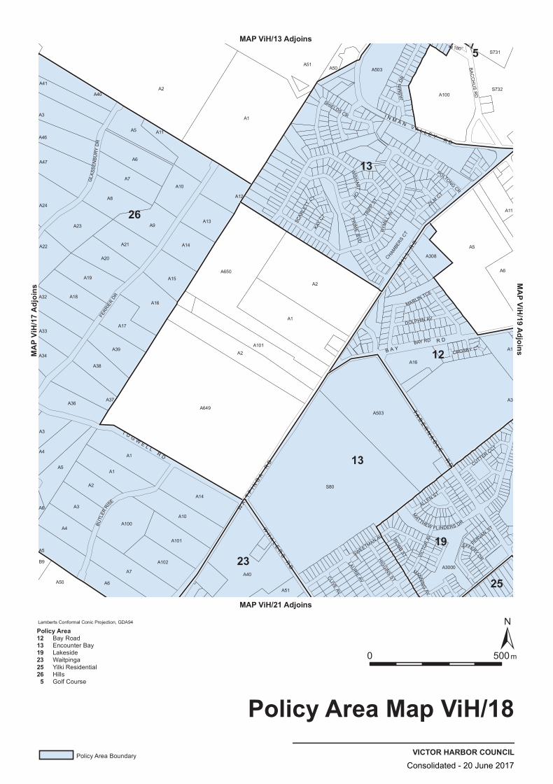
180 o
A3
A6
A15
A14
A1
A51
A308
S731
A100
A7
A51
A2
A24
A47
A40
A50
S732
A32
A37
A649
A650
A22
A46
A19
A20
A9
A2
A3
A3
A16
A1
A5A21
A5
A6
A6
B9
A2
A17
A14
A3
A18
A41
A7A10
A13
A12
A34A39
A1
A6
A16
A101
A10
S80
A8
A50
A1
A102
A40
A1
A503
A3000
A503
A100
A11
A5
A4
A36
A2
A23
A11
A33
A4
A5
A38
A101
MARLIN TCE
FERR
IER
DR
WIS
HAR T
CR
SHIELDS CR
JEFFERY DR
TRIP
P ST
CROSBY C T
MANNIN
G AV
ALLEN ST
VIC
TOR
AV
BA
CC
HU
S R
D
RYM
ILL
AV
POLTONG CR
ROBB
ST
MATTHEW FLINDERS DR
CUTTER CCT
LAURIE AV
HIGG
INS ST
GLA
SS
EN
BU
RY
DR
SWEETMAN AV
PR
IME
BV
D
ZILM CT
JAS
MIN
DR
CLIVE AV
PERVAN
ST
KAY
CTSCAR
LETT
CT
CHAMBE
RS CT
DOLPHIN AV
BUTL
ER RI
SE
BAY RD
TA
BE
RN
AC
LE
RD
WA
I TP
I NG
A R
D
B A Y R D
MI L
L R
D
WH
AL
ER
S R
D
I N M A N V A L L E Y
R D
T U G WE L L
R D
26
12
19
13
13
2325
5
VICTOR HARBOR COUNCIL
Policy Area Map ViH/18
0 500m
Lamberts Conformal Conic Projection, GDA94
Policy Area Boundary
Policy Area121319232526 5
Bay RoadEncounter BayLakesideWaitpingaYilki ResidentialHillsGolf Course
MAP ViH/13 Adjoins
MAP ViH/21 Adjoins
MAP V
iH/17
Adjo
insMAP ViH/19 Adjoins
Consolidated - 20 June 2017
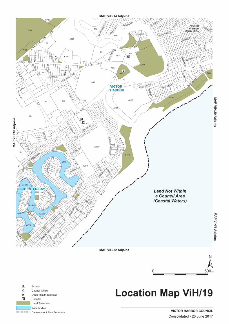
S758
A102
A10A1
A2
A332
A1501
A1503
A6
S730
A508
A279
Q1000
A101
A3
A1
A63
A6S32
A61
A57
A100
A1502
A5
A2
A101
A1512
A55
A56
S732
S760
S787
S716
A11
A408
A1500
KU LLAR
OO RD
NEWLAND ST
CROZIER RD
HENRY ST
BRODERICK TCE
VICTORIA ST
CENTRAL DR
HIN
KLER
ST
BEVERLEY
GR
ISLANDER DR
STURT ST
WARNE ST
CLIPP
ER
CT
RAYM
OR
E LANE
LAKESIDE
CCTH
AR
BO
UR
VIEW
TCE
BA UDIN RD
BU
RKE
ST
CHURCHILL RD
CAN
TER
BURY
RD
GIBSON
AV
ISLAND
ST
INM
AN ST
KING
ST
GR
AN
ITE ST
OVA
L R
D
PHILIP AV
CHARLES ST
GEORGE ST
ESPLANADE
ELLIS AV
AINSLIE
ROBERTS DR
KETCH PL
ENCO
UNTE
R TC
E
SMITH
ST
ME
YE
R S
T
KAREENA AV
MALEN AV
PE
NN
EY
ST
JOLL
Y S
T
LINDSAY ST
WOOD ST
MAT
THEW
FLINDERS DR
OAKHAM ST
MAYFIELD
TCE
LEWORTHY ST
KINGSFORD ST
FORR
EST
ST
TREGO
NNING ST
OVA
L PA
RK
RD
ALMOND AV
NICO
LAS
BAUD
IN DR
RI VER RD
FR
AN
KL
I N
PD
E
G E O R G E M A I N R D
B A Y R D
V I C T O R I A S T
MA
UD
E
ST
TABERNACLE RD
BA
RT
EL
BV
D
KE
NT
DR
E WE N
T C E
A RM
ST R
ON
G
RD
Land Not Withina Council Area
(Coastal Waters)
ENCOUNTER BAY
VICTORHARBOR
VICTORHARBOR
URBAN AREA
VICTOR HARBOR COUNCIL
Location Map ViH/19
0 500m
SchoolCouncil OfficeOther Health ServicesHospitalLocal Reserves
WaterbodiesDevelopment Plan Boundary
MA
P ViH/1 A
djoinsMAP ViH/14 Adjoins
MAP ViH/22 Adjoins
MA
P Vi
H/1
8 A
djoi
nsM
AP ViH
/20 Adjoins
Consolidated - 20 June 2017

S32
A332
A1501
A1503
A6
S730
A508
A279
Q1000
A101
A3
A1
A63
S758
A6
S716
A61
A57
A100
A1502
A5
A2
A101
A1512
A55
A56
S732
S787
S760
A11
A408
A1500
A102
A10A1
A2
CROZIER RD
HENRY ST
BRODERICK TCE
VICTORIA ST
CENTRAL DR
HIN
KLER
ST
BEVERLEY
GR
ISLANDER DR
STURT ST
WARNE ST
CLIPP
ER
CT
RAYM
ORE
LANE
LAKESIDE
CCTH
AR
BO
UR
VIEW
TC
E
BA UDIN RD
BU
RKE
ST
CHURCHILL RD
CAN
TER
BURY
RD
GIBSON
AV
ISLAND
ST
INM
AN ST
KING
ST
GR
AN
ITE ST
OVA
L R
D
PHILIP AV
CHARLES ST
GEORGE ST
ESPLANADE
ELLIS AV
AINSLIE
ROBERTS DR
KETCH PL
ENCO
UNTE
R TC
E
SMITH
ST
ME
YE
R S
T
KAREENA AV
MALEN AV
PE
NN
EY
ST
JOLL
Y S
T
LINDSAY ST
WOOD ST
MAT
THEW
FLINDERS DR
OAKHAM ST
MAYFIELD
TCE
LEWORTHY ST
KINGSFORD ST
FORR
EST
ST
TREGO
NNING ST
OVA
L PA
RK
RD
ALMOND AV
NICO
LAS
BAUD
IN DR
RI VER RD
KU LLAR
OO RD
NEWLAND STF
RA
NK
LI N
PD
E
G E O R G E M A I N R D
B A Y R D
V I C T O R I A S T
MA
UD
E
ST
TABERNACLE RD
BA
RT
EL
BV
D
A RM
ST R
ON
G
RD
E WE N
T C E
KE
NT
DR
Land Not Withina Council Area
(Coastal Waters)
TRANSPORTVICTOR HARBOR COUNCIL
Overlay Map ViH/19
0 500m
Secondary Arterial Roads
Development Plan Boundary
MA
P ViH/1 A
djoinsMAP ViH/14 Adjoins
MAP ViH/22 Adjoins
MA
P Vi
H/1
8 A
djoi
nsM
AP ViH
/20 Adjoins
Consolidated - 20 June 2017
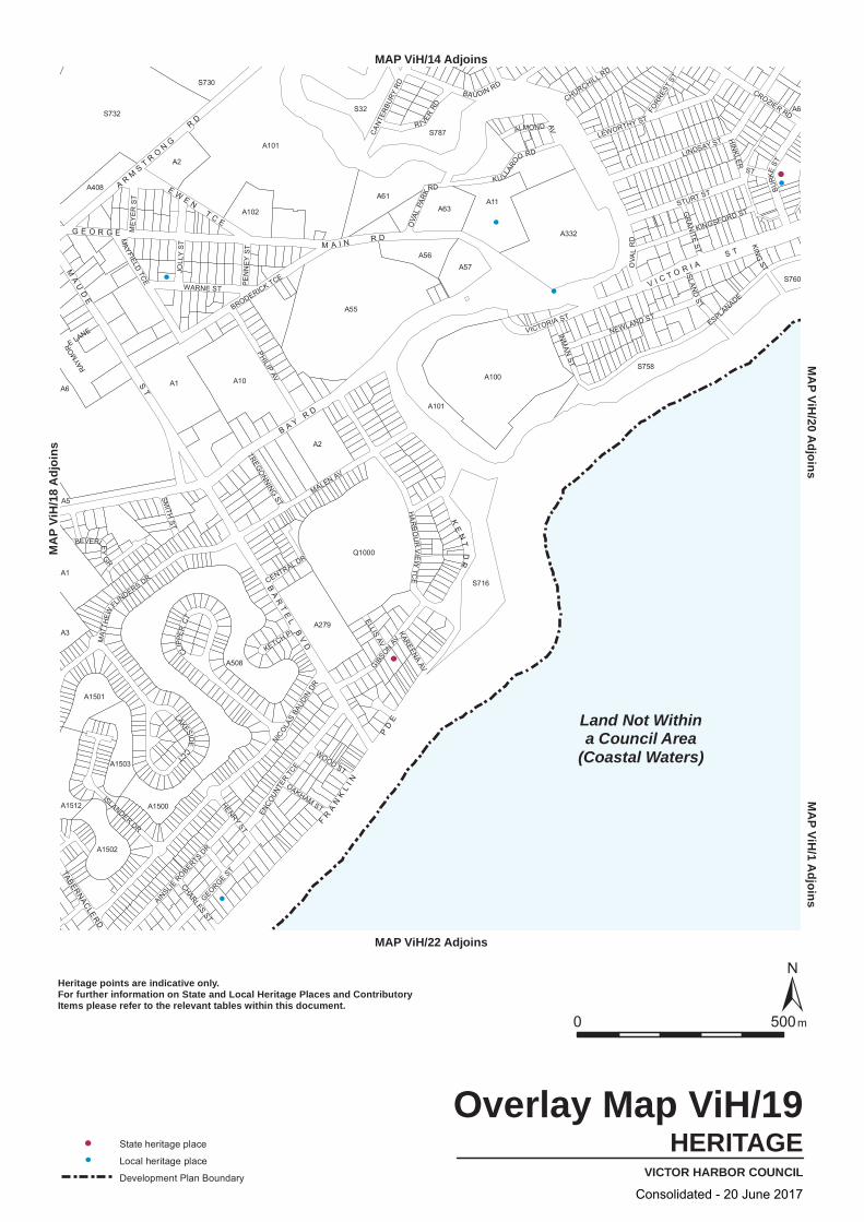
S32
A332
A1501
A1503
A6
S730
A508
A279
Q1000
A101
A3
A1
A63
S758
A6
S716
A61
A57
A100
A1502
A5
A2
A101
A1512
A55
A56
S732
S787
S760
A11
A408
A1500
A102
A10A1
A2
CROZIER RD
HENRY ST
BRODERICK TCE
VICTORIA ST
CENTRAL DR
HIN
KLER
ST
BEVERLEY
GR
ISLANDER DR
STURT ST
WARNE ST
CLIPP
ER
CT
RAYM
OR
E LANE
LAKESIDE
CCTH
AR
BO
UR
VIEW
TCE
BA UDIN RD
BU
RKE
ST
CHURCHILL RD
CAN
TER
BURY
RD
GIBSON
AV
ISLAND
ST
INM
AN ST
KING
ST
GR
AN
ITE ST
OVA
L R
D
PHILIP AV
CHARLES ST
GEORGE ST
ESPLANADE
ELLIS AV
AINSLIE
ROBERTS DR
KETCH PL
ENCO
UNTE
R TC
E
SMITH
ST
ME
YE
R S
T
KAREENA AV
MALEN AV
PE
NN
EY
ST
JOLL
Y S
T
LINDSAY ST
WOOD ST
MAT
THEW
FLINDERS DR
OAKHAM ST
MAYFIELD
TCE
LEWORTHY ST
KINGSFORD ST
FORR
EST
ST
TREGO
NNING ST
OVA
L PA
RK
RD
ALMOND AV
NICO
LAS
BAUD
IN DR
RI VER RD
KU LLAR
OO RD
NEWLAND STF
RA
NK
LI N
PD
E
G E O R G E M A I N R D
B A Y R D
V I C T O R I A S T
MA
UD
E
ST
TABERNACLE RD
BA
RT
EL
BV
D
A RM
ST R
ON
G
RD
E WE N
T C E
KE
NT
DR
Land Not Withina Council Area
(Coastal Waters)
HERITAGEVICTOR HARBOR COUNCIL
Overlay Map ViH/19
0 500m
State heritage place
Local heritage place
Development Plan Boundary
Heritage points are indicative only.For further information on State and Local Heritage Places and ContributoryItems please refer to the relevant tables within this document.
MA
P ViH/1 A
djoinsMAP ViH/14 Adjoins
MAP ViH/22 Adjoins
MA
P Vi
H/1
8 A
djoi
nsM
AP ViH
/20 Adjoins
Consolidated - 20 June 2017
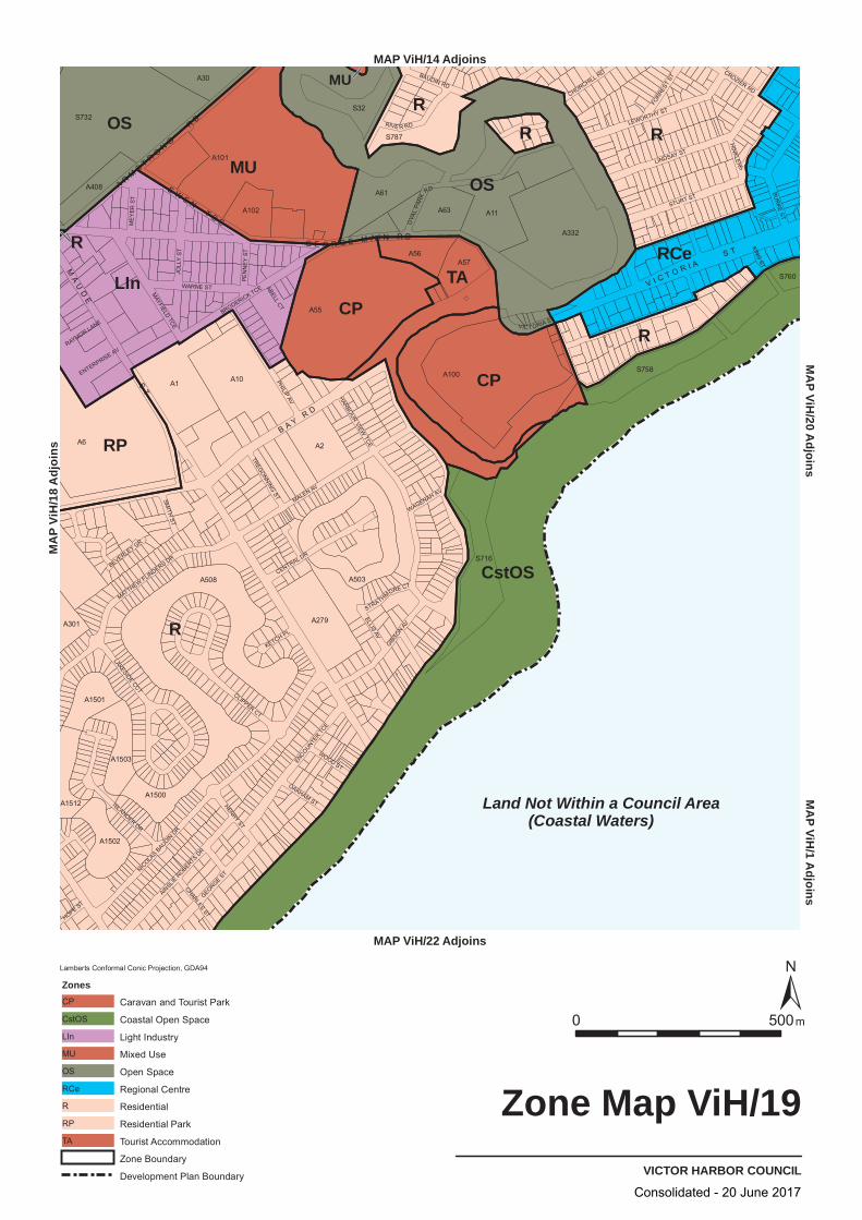
R
R
RR
OS
LIn
CstOS
M
MU
U
CP
OS
CPR
RCe
RP
TA
R
Land Not Within a Council Area (Coastal Waters)
VIC T ORIA ST
MALEN AV
NICOLA
SBAUDIN
DR
LINDSAY ST
BAUDIN RD
PHILIP AV
STURT ST
HARBOURVIEW
TCE
GIBSON AV
BUR
KEST
LEWORTHY ST
BRODERICK TCEWARNE ST
GEORGEST
CENTRAL DR
JOLL
Y ST
ISLANDERDR
MATTHEWFLINDERS DR
ENCOUNTE
RTC
E
CLIPPER CT
RIVE R RD
MAYFIELD
TCE
CROZIER RD
LAKESIDE CCT
AINSLIE
ROBERTS
DR
HENRY ST
WOOD ST
CHARLES ST
ELLIS AV
FORR
EST
ST
SMITH
ST
OAKHAM ST
HIN
KLER
S T
ME
YER
ST
PEN
NE
Y ST
RAYMOR LANE
KETCH PL
CHURCHILL RD
OVA
LPA
RK
RD
TREGONNINGST
HOPE ST
KING
ST
ABELLCT
BEVERLEY GR
STRATHMORE CT
WAGENAH AV
ENTERPRISE AV
A6
A55
A101
A508
S732
A100
A332
A1 A10
S716
A2
A11
A61
A503
A279
S758
S32
S787
A63
A56A57
A30
A1502
A102
A1503
A408
A1500
A1501
A1512
A301
S760
VICTOR HARBOR COUNCIL
Zone Map ViH/19
0050 m
Lamberts Conformal Conic Projection, GDA94
Zones
Caravan and Tourist ParkCP
Coastal Open SpaceCstOS
Light IndustryLIn
Mixed UseMU
Open SpaceOS
Regional CentreRCe
ResidentialR
Residential ParkRP
Tourist AccommodationTA
Zone Boundary
Development Plan Boundary
MA
Pi VH
/1A
j doisn
MAP ViH/14 Adjoins
MAP ViH/22 Adjoins
sniojdA 81/
HiV PA
MM
AP
Vi2/
H0
j dA
oisn
G E O R G E M A I N R D
B A YR D
V I C T O R I AS T
E WE N
T C E
A RM
ST R
ON
G
RD
MA
UD
E
ST
Consolidated - 20 June 2017

S716
A2
A55
A56
A63
A101
A2
A332
A1503
A279
Q3005
A101
A100S758
S732
A102
A61
A57
A1502
A408
A1
S32
S787
S760
A1
A5
A6A10
A3
A1512
A1501
A1500
A11
A508
A30
LEWORTHY ST
KINGSFORD ST
FORR
EST
ST
TREGO
NNINGST
OVA
LPA
RK
RD
ALMONDAV
NICO
LAS
BAUD
INDR
LAKESIDECCT
RI VERRD
KU LLAR
OORD
NEWLAND ST
CROZIER RD
HENRYST
BRODERICK TCE
CENTRAL DR
ISLANDERDR
HIN
KLER
ST
BEVERLEY
GR
STURT ST
CLIPP
ER
CT
VICTORIA ST
WARNE ST
RAYM
OR
LANE
HA
RB
OU
RV
IEWT
CE
BAUDIN RD
BU
RKE
ST
CHURCHILL RD
CAN
TER
BUR
YR
D
GIBSON
AV
ISLAND
ST
INM
AN ST
KING
ST
GR
AN
ITEST
OVA
LR
D
LITTLEB
U
RKE ST
PHILIPAV
CHARLESST
GEORGEST
ESPLANADE
AINSLIE
ROBERTSDR
KETCH PL
ENCO
UNTE
RTC
E
ELLISAV
SMITH
ST
ME
YE
RS
T
KAREENAAV
MALEN AV
PE
NN
EY
ST
JOLL
YS
TLINDSAY ST
WOOD ST
MAT
THEW
FLINDERS DR
OAKHAMST
MAYFIELD TCE
FR
AN
KL
I N
PD
E
G E O R G E M A I N R D
B A YR D
V I C T O R I AS T
BA
RT
EL
BV
D
MA
UD
E
ST
KE
NT
DR
E WE N
T C E
A RM
ST R
ON
G
RD
TABERNACLERD
Land Not Withina Council Area
(Coastal Waters)
21165
8
8
10
7
1 30
12
19
13
25
24
24
2222
VICTOR HARBOR COUNCIL
Policy Area Map ViH/19
0050 m
Lamberts Conformal Conic Projection, GDA94
Policy Area Boundary
Development Plan Boundary
Policy Area 110121316192122242530 5 7 8
Home IndustryShoppingBay RoadEncounter BayCanterbury WestLakesideMount BreckanTown CentreWaterfrontYilki ResidentialInman River Tourist RecreationGolf CourseBurke Street CharacterBusiness
MA
PVi
/H
1A
doj
sni
MAP ViH/14 Adjoins
MAP ViH/22 Adjoins
sniojdA
81/HiV
PA
MM
AP
V/
iH20
Aj do
nis
Consolidated - 20 June 2017
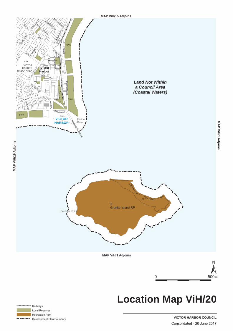
A1
S763
S776
S760
Q2
S766
A106
CROZIER RD
BR
IDG
E TC
EFL
IND
ER
S P
DE
ACRAM
AN ST
RAIL WAY
TCE
HILL ST
ALBE
RT
PL
WILLS
ST
EYRE TCE
CARLYLE
ST
ESPLANADE
SEYMOUR LANE
CORAL ST
DENNI
S PL
BRECKAN AV
CORNHILL RD
MC
KIN
LAY S
T
GRANITE
ISLAND RD
HI N
DM
AR
SH
RD
V I C T O R I A S T
TO
RR
EN
S
ST
G
RA
NI T
E
I S L A N D R D
OC
EA
N S
T
SE
A VI E
W
RD
Land Not Withina Council Area
(Coastal Waters)
VICTORHARBOR
Granite Island RP
VICTORHARBOR
URBAN AREA
PolicePoint
Boulder Point
VictorHarbor
VICTOR HARBOR COUNCIL
Location Map ViH/20
0 500m
RailwaysLocal ReservesRecreation ParkDevelopment Plan Boundary
MAP ViH/1 Adjoins
MA
P ViH/1 A
djoinsMAP ViH/15 Adjoins
MA
P Vi
H/1
9 A
djoi
ns
Consolidated - 20 June 2017
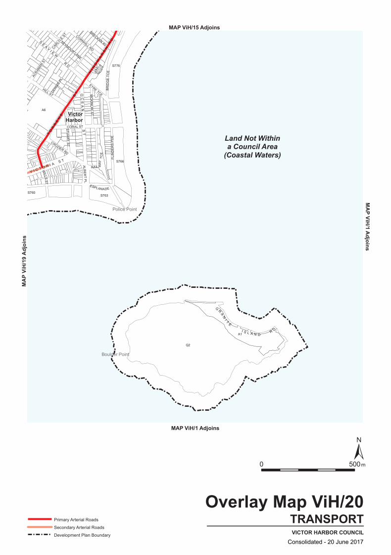
S763
Q2
S776
A1
S760
A6
S766
STU
AR
T S
T
FLIN
DE
RS
PD
E
ACRAM
AN ST
RAIL WAY
TCE
HILL ST
ALBE
RT
PL
WILLS
ST
EYRE TCE
CARLYLE
ST
ESPLANADE
SEYMOUR LANE
CORAL ST
DENNI
S PL
BRECKAN AV
CORNHILL RD
MC
KIN
LAY S
T
CROZIER RD
BR
IDG
E TC
EHI N
DM
AR
SH
RDS
EA V
I EW
RD
TO
RR
EN
S
ST
V I C T O R I A S T
OC
EA
N S
TG
RA
NI T
E
I S L A N D R D
Land Not Withina Council Area
(Coastal Waters)
Police Point
Boulder Point
VictorHarbor
TRANSPORTVICTOR HARBOR COUNCIL
Overlay Map ViH/20
0 500m
Primary Arterial Roads
Secondary Arterial Roads
Development Plan Boundary
MAP ViH/1 Adjoins
MAP ViH/1 AdjoinsMAP ViH/15 Adjoins
MAP V
iH/19
Adjo
ins
Consolidated - 20 June 2017
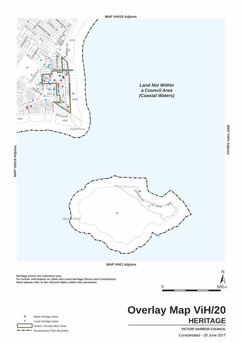
S763
Q2
S776
A1
S760
A6
S766
STU
AR
T S
T
FLIN
DE
RS
PD
E
ACRAM
AN ST
RAIL WAY
TCE
HILL ST
ALBE
RT
PL
WILLS
ST
EYRE TCE
CARLYLE
ST
ESPLANADE
SEYMOUR LANE
CORAL ST
DENNI
S PL
BRECKAN AV
CORNHILL RD
MC
KI N
LAY S
T
CROZIER RD
BR
IDG
E TC
EHI N
DM
AR
SH
RDS
EA V
I EW
RD
TO
RR
EN
S
ST
V I C T O R I A S T
OC
EA
N S
TG
RA
NI T
E
I S L A N D R D
Land Not Withina Council Area
(Coastal Waters)
Police Point
Boulder Point
Victor Harbor
HERITAGEVICTOR HARBOR COUNCIL
Overlay Map ViH/20
0 500m
State heritage place
Local heritage place
Historic Conservation Area
Development Plan Boundary
Heritage points are indicative only.For further information on State and Local Heritage Places and ContributoryItems please refer to the relevant tables within this document.
MAP ViH/1 Adjoins
MA
P ViH/1 A
djoinsMAP ViH/15 Adjoins
MA
P Vi
H/1
9 A
djoi
ns
Consolidated - 20 June 2017
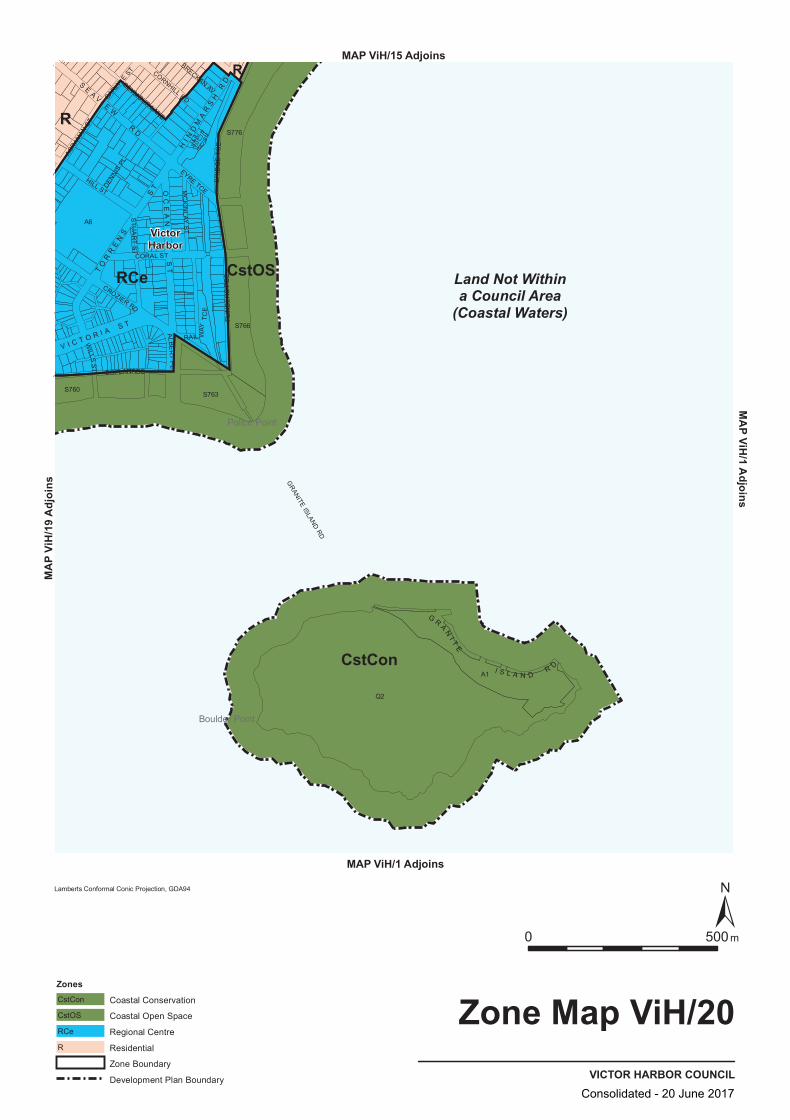
CstOSRCe
CstCon
R
R
S760
A6
S766
Q2
S763
A1
S776
ACRAM
AN ST
STU
AR
T S
T
FLIN
DE
RS
PD
E
HILL ST
ALBE
RT
PL
RAIL WAY
TCE
WILLS
ST
EYRE TCE
CARLYLE
ST
ESPLANADE
SEYMOUR LANE
CORAL ST
DENNI
S PL
BRECKAN AV
BR
IDG
E TC
E
CORNHILL RD
MC
KIN
LAY S
T
GRANITE
ISLAND RD
CROZIER RD
HI N
DM
AR
SH
RD
TO
RR
EN
S
ST
G R AN
I TE
I S L A N D R D
SE
A VI E
W
RD
V I C T O R I A S T
OC
EA
N S
T
Land Not Withina Council Area
(Coastal Waters)
Police Point
Boulder Point
VictorHarbor
VICTOR HARBOR COUNCIL
Zone Map ViH/20
0 500m
MAP ViH/1 Adjoins
MAP ViH/1 AdjoinsMAP ViH/15 Adjoins
MAP V
iH/19
Adjo
ins
Lamberts Conformal Conic Projection, GDA94
ZonesCoastal ConservationCstCon
Coastal Open SpaceCstOS
Regional CentreRCe
ResidentialR
Zone Boundary
Development Plan BoundaryConsolidated - 20 June 2017
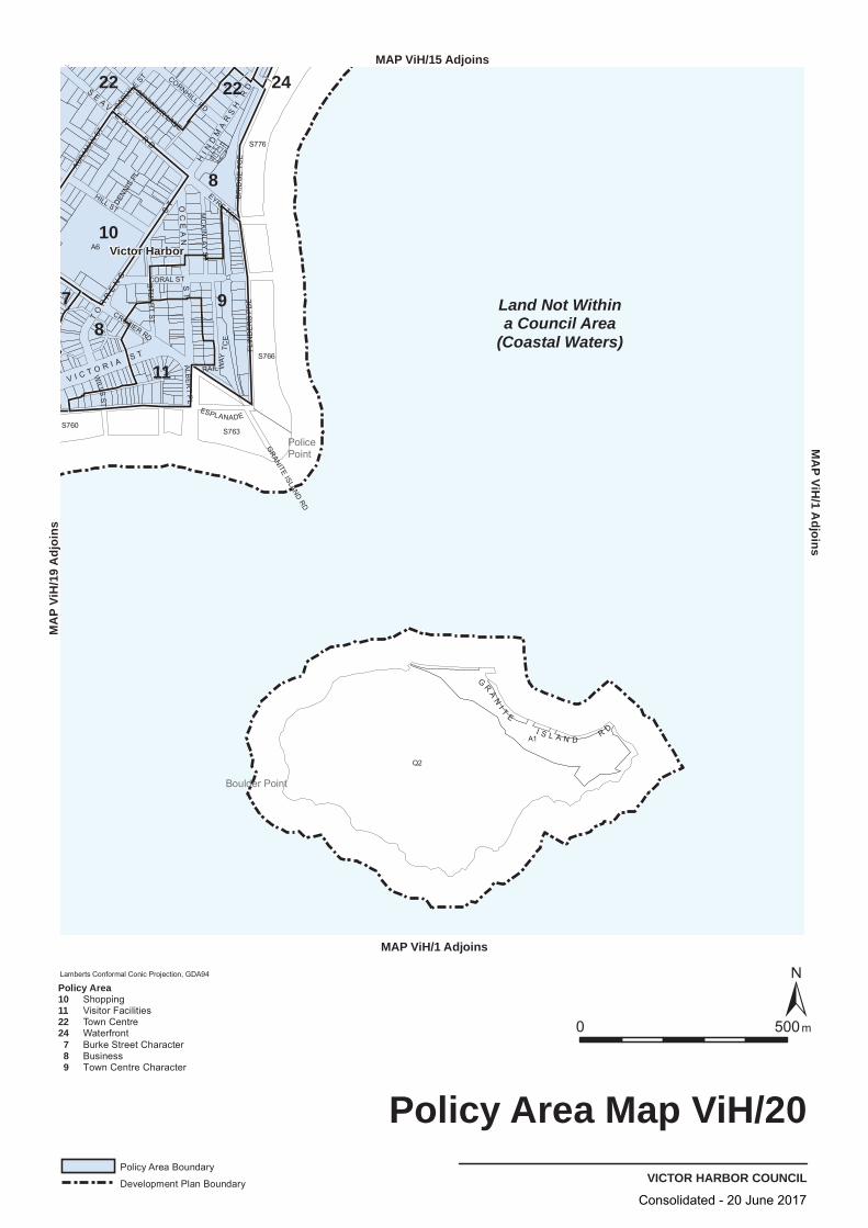
Q2
A1
S776
S760
A6
S766
S763
BR
IDG
E TC
E
CORNHILL RD
MC
KI N
LAYS
T
GRANITE
ISLANDRD
CROZIER RD
EYRE TCE
STU
AR
TS
T
FLIN
DE
RS
PD
E
ACRA
MAN
ST
HILL ST
ALBE
RT
PL
RAIL WAY
TCE
WILLS
ST
CARLYLE
ST
ESPLANADE
SEYMOUR LANE
CORAL ST
DENNI
SPL
HI N
DM
AR
SH
RD
TO
RR
EN
S
ST
G
RA
NI T
E
I S L A N DR D
SE
A VI E
W
RD
V I C T O R I AS T
OC
EA
NS
T
Land Not Withina Council Area
(Coastal Waters)
22 22
8
8
10
9
11
24
7
PolicePoint
Boulder Point
Victor Harbor
VICTOR HARBOR COUNCIL
Policy Area Map ViH/20
0050 m
Lamberts Conformal Conic Projection, GDA94
Policy Area Boundary
Development Plan Boundary
Policy Area10112224 7 8 9
ShoppingVisitor FacilitiesTown CentreWaterfrontBurke Street CharacterBusinessTown Centre Character
MAP ViH/1 Adjoins
PA
M/
HiV
dA
1oji
snMAP ViH/15 Adjoins
sniojdA 91/
HiV PA
M
Consolidated - 20 June 2017
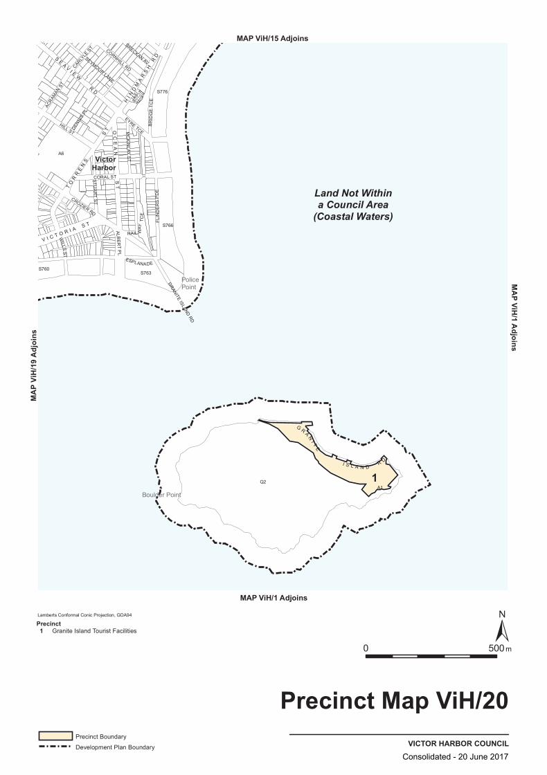
S760
S776
S763
A6
S766
Q2A1
BR
IDG
E TC
EFL
IND
ER
S P
DE
CARLYLE
ST
ACRAM
AN ST
RAIL WAY
TCE
HILL ST
ALBE
RT
PL
WILLS
ST
EYRE TCE
STU
AR
T S
T
ESPLANADE
SEYMOUR LANE
CORAL ST
DENNI
S PL
BRECKAN AV
CORNHILL RD
MC
KIN
LAY S
T
GRANITE
ISLAND RD
CROZIER RD
HI N
DM
AR
SH
RDS
EA V
I EW
RD
V I C T O R I A S T
TO
RR
EN
S
ST O
CE
AN
ST
G R AN
I TE
I S L A N D R D
Land Not Withina Council Area
(Coastal Waters)
1
PolicePoint
Boulder Point
VictorHarbor
VICTOR HARBOR COUNCIL
Precinct Map ViH/20
0 500m
MAP ViH/1 Adjoins
MAP ViH/1 AdjoinsMAP ViH/15 Adjoins
MAP V
iH/19
Adjo
ins
Lamberts Conformal Conic Projection, GDA94
Precinct Boundary
Development Plan Boundary
Precinct 1 Granite Island Tourist Facilities
Consolidated - 20 June 2017

A231
A1
A2
S188
A1000
A21
A6
A4
A91
A1
A50
A347
A7
A346A2
A29
A12
A40
A51
A5
S3
A2
A122
VIKING
ST
LAURIE AV
BLUFF CR
STO
NE
HU
T C
CT
PARK
AV
VICTOR AV
KRILL CT
SOLW
AY
CR
ROLAND RD
RU
MB
ELO
W S
T
MIL
LAR
D CT
RUSSELL ST
SIMPSON RD
CLA
IR AV
CAKEBREAD RD
RIDGEW
AY ST
WH
ITE
CR
HORIZON WY
MOLLIEN AV
MINNAMO ORA CT
THEISENGER CT
ORCA P
L
CRY STA
L CT
RIDGE
AVH
AR
PO
ON
AV
CLIVE AV
NEIGHBOU
R ST
HUMP BACK RD
HIGG
INS ST
ED
DY
CT
PIL
OT
CT
HOPE ST
FELL ST
MAYFL OWER
CT
FOUNTAIN AV
INN
ES
AV
BOLGER WY
ISLA
ND
VIE
W C
R
OY
ST E
R A V
T ITE
AVSE
ACRE
ST
AV
GRIBBLE
CT
HA
RT
AV
BAYVIEW
GR
NAN
YAR
I AV
GILES ST
PETR
EL AV
MO
ONY
A AV
NU
NK
ER
I AV
WHI
TE C
L
HODGE AV
CYGNET CT
KIR
BY
ST
PAS
SATT
ST
WALLAGE CTS
HA
NN
ON
ST
BUFFALO CTDAV
IES
ST
TW
IN
F IG S CT
SOUTHERN RIGHT CR
NEVIN AV
OLIV
EB
AN
K C
R
KI N
GS
BE
AC
H R
D
MIN
KE W
HA
LE D
R
RA
MINJE
RI CR
ROSEMARY CT
JOY
STDO
DSO
N RD
DO
DS
ON
RD
INV E
STIG
ATO
R C
R
COORO
NG C
R
NO
RM
A C
R
POLLARD CT
B A T T Y E
R D
WH
AL
ER
S R
D
TH
RE
E G
UL
LI E
S R
D
J A GG
E R R D
W A I T P I N G A
RD
O L D R D
FR
AN
KL
I N P
DE
Land Not W ithina Council Area
(Coastal W aters)
ENCOUNTER BAY
WAITPINGA
EncounterBay
VICTOR HARBOR COUNCIL
Location Map ViH/21
0 500m
Local Reserves
Development Plan Boundary
MAP ViH/18 Adjoins
MAP ViH/7 Adjoins
MAP V
iH/7
Adjoi
nsMAP ViH/22 Adjoins
Consolidated - 20 June 2017

A1
S188
A1000
A21
A6
A4
A91
A1
A50
A347
A7
A346 A2
A29
A12
A40
A51
A5
S3
A231
A122
A2
A2
VIKING
ST
LAURIE AV
BLUFF CR
STO
NE
HU
T C
CT
PARK
AV
VICTOR AV
KRILL CT
SOLW
AY
CR
ROLAND RD
RU
MB
ELO
W S
T
MIL
LAR
D CT
RUSSELL ST
SIMPSON RD
CLA
IR AV
CAKEBREAD RD
RIDGEW
AY ST
WH
ITE
CR
HORIZON WY
MOLLIEN AV
MINNAMO ORA CT
THEISENGER CT
ORCA P
L
CRY STA
L CT
RIDGE
AVH
AR
PO
ON
AV
CLIVE AV
NEIGHBOU
R ST
HUMP BACK RD
HIGG
INS ST
ED
DY
CT
PIL
OT
CT
HOPE ST
FELL ST
MAYFL OWER
CT
FOUNTAIN AV
INN
ES
AV
BOLGER WY
ISLA
ND
VIE
W C
R
OY
ST E
R A V
T ITE
AVSE
ACRE
ST
AV
GRIBBLE
CT
HA
RT
AV
BAYVIEW
GR
NAN
YAR
I AV
GILES ST
PETR
EL AV
MO
ONY
A AV
NU
NK
ER
I AV
WHI
TE C
L
HODGE AV
CYGNET CT
KIR
BY
ST
PAS
SATT
ST
WALLAGE CTS
HA
NN
ON
ST
BUFFALO CTDAV
IES
ST
TW
IN
F IG S CT
SOUTHERN RIGHT CR
NEVIN AV
OLIV
EB
AN
K C
R
KI N
GS
BE
AC
H R
D
MIN
KE W
HA
LE D
R
RA
MINJE
RI CR
ROSEMARY CT
JOY
STDO
DSO
N RD
DO
DS
ON
RD
INV E
STIG
ATO
R C
R
COORO
NG C
R
NO
RM
A C
R
POLLARD CT
B A T T Y E
R D
WH
AL
ER
S R
D
TH
RE
E G
UL
LI E
S R
D
J A GG
E R R D
W A I T P I N G A
RD
O L D R D
FR
AN
KL
I N P
DE
Land Not W ithina Council Area
(Coastal W aters)
EncounterBay
HERITAGEVICTOR HARBOR COUNCIL
Overlay Map ViH/21
0 500m
Local heritage place
Development Plan Boundary
Heritage points are indicative only.For further information on State and Local Heritage Places and ContributoryItems please refer to the relevant tables within this document.
MAP ViH/18 Adjoins
MAP ViH/7 Adjoins
MAP V
iH/7
Adjoi
nsMAP ViH/22 Adjoins
Consolidated - 20 June 2017
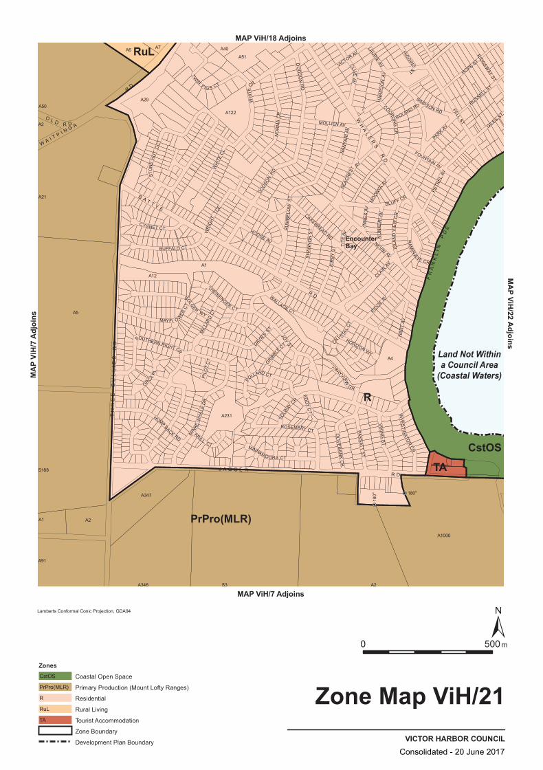
CstOS
RuL
R
TA
PrPro(MLR)
180o
180o
A6
A5
A7
A231
A51
A347
A1
S3
A1000
A2
A1
A346
A122
A2
A4
A2
S188
A50A29
A12
A40
A91
A21
STO
NE
HU
T C
CT
ROLAND RD
KRILL CT
LAURIE AV
BLUFF CR
PARK
AV
VICTOR AV
NEVIN AV
SOLW
AY
CR
INV
ES
TIGATO
R C
R
RU
MB
ELO
W S
T
MIL
LAR
D CT
RUSSELL ST
SIMPSON RD
CLA
IR AV
CAKEBREAD RD
RIDGEW
AY ST
WH
ITE
CR
HORIZON WY
MOLLIEN AV
MINNAMO ORA CT
THEISENGER CT
WH
ITE
CL
ORCA P
L
CRY STA
L CT
RIDGE
AVH
AR
PO
ON
AV
CLIVE AV
WR
IGH
T TC
E
HUMP BACK RD
HIGG
INS ST
ED
DY
CT
PIL
OT
CT
HOPE ST
FELL ST
MAYFL OWER
CT
I NN
ES
AV
FOUNTAIN AV
BOLGER WY
ISLA
ND
VIE
W C
R
TITE
AVSE
ACRE
ST
AV
GRIBBLE
CT
HA
RT
AV
BAYVIEW
GR
NAN
YAR
I AV
NU
NK
ERI A
V
GILES ST
PETR
EL AV
MO
ONY
A AV
HODGE AV
CYGNET CT
KIR
BY
ST
PAS
SATT
ST
WALLAGE CTS
HA
NN
ON
ST
BUFFALO CTDAV
IES
ST
TW
IN
F IG S CT
DODS
ON
RD
DO
DS
ON
RD
SOUTHERN RIGHT CR
OLIV
EB
AN
K C
R
MIN
KE W
HA
LE D
R
ROSEMARY CT
JOY
ST
RA
MINJE
RI CR
COORO
NG C
R
NO
RM
A C
R
POLLARD CT
VIKING
ST
B A T T Y E
R D
WH
AL
ER
S R
D
TH
RE
E G
UL
LI E
S R
D
J A G G E R R D
O L D R D
W A I T P I N G A
RD
FR
AN
KL
I N P
DE
Land Not Withina Council Area
(Coastal Waters)
EncounterBay
VICTOR HARBOR COUNCIL
Zone Map ViH/21
0 500m
Lamberts Conformal Conic Projection, GDA94
ZonesCoastal Open SpaceCstOS
Primary Production (Mount Lofty Ranges)PrPro(MLR)
ResidentialR
Rural LivingRuL
Tourist AccommodationTA
Zone Boundary
Development Plan Boundary
MAP ViH/18 Adjoins
MAP ViH/7 Adjoins
MAP V
iH/7
Adjoi
nsMAP ViH/22 Adjoins
Consolidated - 20 June 2017
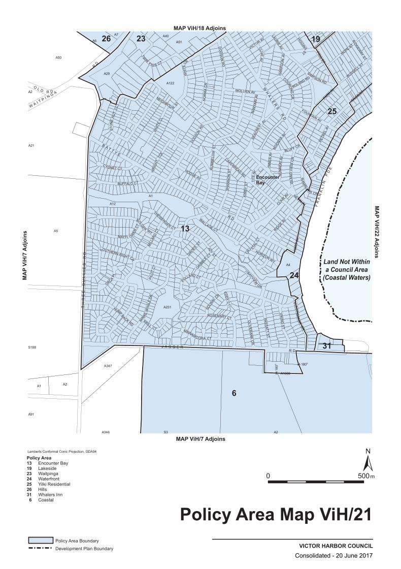
180o
180o
A122
A2
S188
A50
A29
A12
A40
A91
A21
A5
A7
A231
A51
A347
A1
S3
A1000
A2
A1
A346
A4
A2
A6
COORO
NG C
R
NO
RM
A C
R
POLLARD CT
VIKING
ST
SOLW
AY
CR
LAURIE AV
BLUFF CR
PARK AV
VICTOR AV
STO
NE
HU
T C
CT
NEVIN AV
KRILL CT
ROLAND RD
RU
MB
ELO
W S
T
MIL
LAR
D CT
RUSSELL ST
SIMPSON RD
CLA
IR AV
CAKEBREAD RD
RIDGEW
AY ST
WH
ITE
CR
HORIZON WY
MOLLIEN AV
MINNAMO ORA CT
THEISENGER CT
WH
ITE
CL
ORCA P
L
CRY STA
L CT
RIDGE
AVH
AR
PO
ON
AV
CLIVE AV
NEIGHBOU
R ST
WR
IGH
T TC
E
HUMP BACK RD
HIGG
INS ST
ED
DY
CT
PIL
OT
CT
HOPE ST
FELL ST
MAYFL OWER
CT
I NN
ES
AV
FOUNTAIN AV
BOLGER WY
ISLA
ND
VIE
W C
R
TITE
AVSE
ACRE
ST
AV
GRIBBLE
CT
HA
RT
AV
BAYVIEW
GR
NAN
YAR
I AV
NU
NK
ERI A
V
GILES ST
PETR
EL AV
MO
ONY
A AV
HODGE AV
CYGNET CT
KIR
BY
ST
PAS
SATT
ST
WALLAGE CTS
HA
NN
ON
ST
BUFFALO CTDAV
IES
ST
TW
IN
F IG S CT
DODS
ON
RD
DO
DS
ON
RD
SOUTHERN RIGHT CR
OLIV
EB
AN
K C
R
MIN
KE W
HA
LE D
R
ROSEMARY CT
JOY
ST
RA
MINJE
RI CR
INV E
STIG
ATO
R C
R
B A T T Y E
R D
WH
AL
ER
S R
D
TH
RE
E G
UL
LI E
S R
D
J A G G E R R D
W A I T P I N G A
RD
O L D R D
FR
AN
KL
I N P
DE
Land Not Withina Council Area
(Coastal Waters)
26 19
13
23
25
24
31
6
EncounterBay
VICTOR HARBOR COUNCIL
Policy Area Map ViH/21
0 500m
Lamberts Conformal Conic Projection, GDA94
Policy Area Boundary
Development Plan Boundary
Policy Area13192324252631 6
Encounter BayLakesideWaitpingaWaterfrontYilki ResidentialHillsWhalers InnCoastal
MAP ViH/18 Adjoins
MAP ViH/7 Adjoins
MAP V
iH/7
Adjoi
nsMAP ViH/22 Adjoins
Consolidated - 20 June 2017
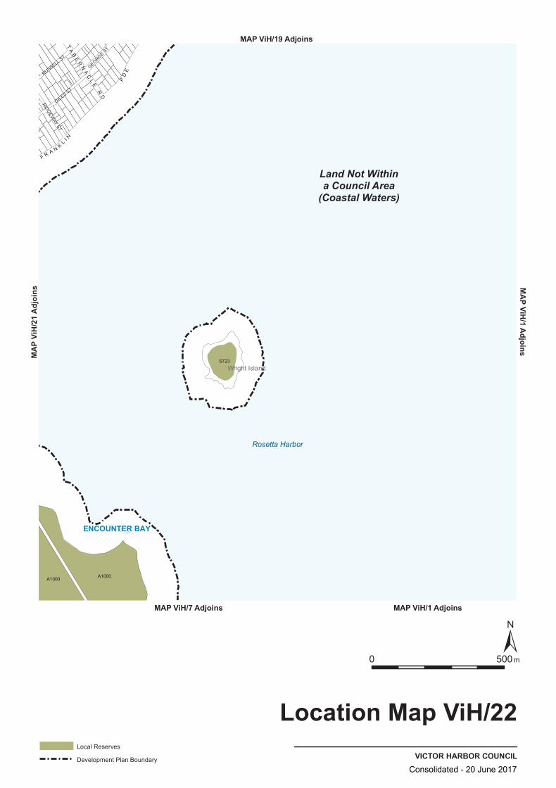
A1000 A1000
S723
GILES ST
RUSSELL ST
RIDGEW
AY ST
GEORGE ST
F R A N KL
I N
PD
E
TA
BE
RN
AC
LE
RD
Land Not Withina Council Area
(Coastal Waters)
ENCOUNTER BAY
Wright Island
Rosetta Harbor
VICTOR HARBOR COUNCIL
Location Map ViH/22
0 500m
Local Reserves
Development Plan Boundary
MAP ViH/1 Adjoins
MA
P ViH/1 A
djoinsMAP ViH/19 Adjoins
MAP ViH/7 Adjoins
MA
P Vi
H/2
1 A
djoi
ns
Consolidated - 20 June 2017
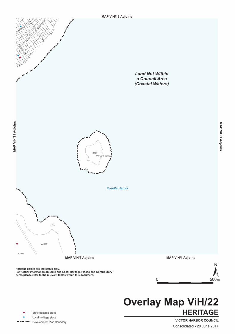
A1000
A1000
S723
GILES ST
RUSSELL ST
RIDGEW
AY ST
GEORGE ST
F R A N KL
I N
PD
E
TA
BE
RN
AC
LE
RD
Land Not Withina Council Area
(Coastal Waters)
Wright Island
Rosetta Harbor
HERITAGEVICTOR HARBOR COUNCIL
Overlay Map ViH/22
0 500m
State heritage place
Local heritage place
Development Plan Boundary
Heritage points are indicative only.For further information on State and Local Heritage Places and ContributoryItems please refer to the relevant tables within this document.
MAP ViH/1 Adjoins
MAP ViH/1 AdjoinsMAP ViH/19 Adjoins
MAP ViH/7 Adjoins
MAP V
iH/21
Adjo
ins
Consolidated - 20 June 2017

CstOS
CstOS
LCe
R
NO ZONES
PrPro(MLR)A1000
A1000
S723
GILES ST
RUSSELL ST
RIDGEW
AY ST
GEORGE ST
F R AN
KL
I N
PD
E
TA
BE
RN
AC
LE
RD
Land Not Withina Council Area
(Coastal Waters)
Wright Island
Rosetta Harbor
VICTOR HARBOR COUNCIL
Zone Map ViH/22
0 500m
Lamberts Conformal Conic Projection, GDA94
ZonesCoastal Open SpaceCstOS
Local CentreLCe
NO ZONESNO ZONES
Primary Production (Mount Lofty Ranges)PrPro(MLR)
ResidentialR
Zone Boundary
Development Plan Boundary
MAP ViH/1 Adjoins
MAP ViH/1 AdjoinsMAP ViH/19 Adjoins
MAP ViH/7 Adjoins
MAP V
iH/21
Adjo
ins
Consolidated - 20 June 2017
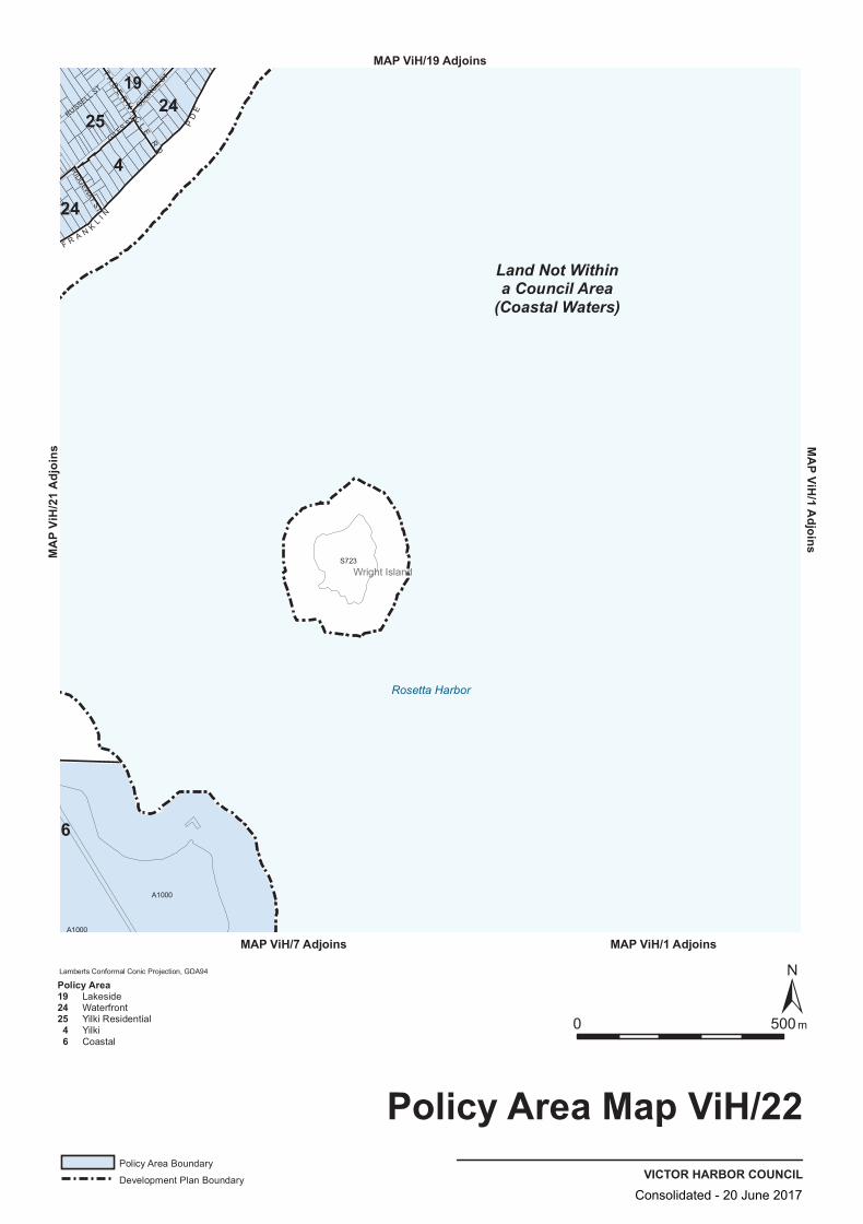
S723
A1000
A1000
GILES ST
RUSSELL ST
RIDGEW
AY ST
GEORGE ST
F R A N KL I N
PD
E
TA
BE
RN
AC
LE
RD
Land Not Withina Council Area
(Coastal Waters)
1925
4
24
24
6
Wright Island
Rosetta Harbor
VICTOR HARBOR COUNCIL
Policy Area Map ViH/22
0 500m
Lamberts Conformal Conic Projection, GDA94
Policy Area Boundary
Development Plan Boundary
Policy Area192425 4 6
LakesideWaterfrontYilki ResidentialYilkiCoastal
MAP ViH/1 Adjoins
MAP ViH/1 AdjoinsMAP ViH/19 Adjoins
MAP ViH/7 Adjoins
MAP V
iH/21
Adjo
ins
Consolidated - 20 June 2017

Consolidated - 20 June 2017

Error! Unknown document property name. Mapping Section
Bushfire Risk BPA Maps
415
Bushfire Risk BPA Maps
Consolidated - 20 June 2017

Consolidated - 20 June 2017

LandNot Within a Council
Area (Coastal Waters)
AlexandrinaCouncil
YankallilaCouncil
Myponga
PortElliot
Inman Valley
Waitpinga
Victor Harbor
BPA Map ViH/3
BPA Map ViH/4 BPA Map ViH/5
BPA Map ViH/6BPA Map ViH/7
BPA Map ViH/2
VICT
OR
HA
RB
OR
RD
AD
ELAIDE
RD
HIND
MARSH RD
IN MAN VALLEY RD
NORTH TCE
PORT ELLIOT RD
HINDMARSH TIERS RD
GO
OLW
A RD
MAIN SOUTH RD
VICTOR HARBOR COUNCIL
Bushfire Protection AreaBPA Map ViH/1
BUSHFIRE RISK
0 15 km
High Bushfire Risk
Medium Bushfire Risk
Excluded area from bushfire protection planning provisions
Development Plan Boundary
See enlargement map for accurate representation.
Consolidated - 20 June 2017
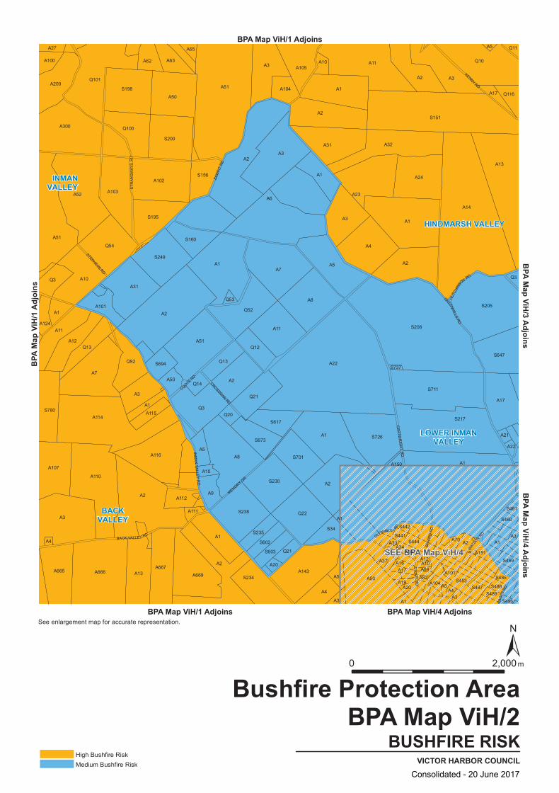
SEE BPA Map ViH/4
S780
A1
A7
A115
A102
S160
A63
S230
A4
A1
A50
S441
S442
S444
A12
A84
A70
A10
Q53
Q21
A7
A1
A8
A1
A2
A1
A667
Q3
A101
S694
Q101
A50
A9
S235
S602
S603
S234 A5
A16
A4
A101
A2
A1
S460
Q20
A1
A3
S701
A3
A14
A2
A107
A110
A2
A12
A10A31
A3
A300 Q100
A62
A17
A5
A151
S488
S496
A2
A11
A51
S461
Q3
A3
Q13
A103
A1
A20
A19A20
S485
S469
A22
A4
A2
A24
S217
A21
A13
A3
A5
A17
A3
A665 A13 A669
A51
A11
Q54
Q3
A51
A100
A111
A8
A143
A3
A82
A150
A3
A5
A104
A3A10
A105
A4
A666
A2
A116
S195
S200
S34
A33
A2
A14
A104
A1
S453S487
A1
Q14A2
Q52
S673
S617
A31
A23
S726
S711
A17
S205
S151
Q10
A124
A52
Q92
A114
A50
A2
A65
S238 Q22
Q12
A1
A11
Q11
A22
A112
A1
S249
A27
A200S198
Q21
A37
A34
A10
S489
A5
S156
Q13
A6
S737
A32
S208
S647
Q116
SPR
ING
RD
INM
AN
VAL LE
Y R
D
GREENHILLS
RD
GLENVALE RD
WAT
SO
N
RD
CROSSMAN RD
COOTE RD
PAG
ES R
D
STEPHENS RD
HUTC
HINS
ON RD
SAW
PIT
RD
MEMORY GR
ST
OCK
RD
STR
AN
GW
AYS
RD
KENNY RD
BACK VALLEY RD
CA
RTW
RIG
HT
RD
HINDMARSH VALLEY
INMANVALLEY
LOWER INMANVALLEY
BACKVALLEY
BUSHFIRE RISKVICTOR HARBOR COUNCIL
Bushfire Protection AreaBPA Map ViH/2
High Bushfire RiskMedium Bushfire Risk
BPA Map ViH/1 Adjoins
BPA Map ViH/1 Adjoins
BPA
Map V
iH/1
Adjoi
ns
BPA Map ViH/4 Adjoins
BPA Map ViH/3 AdjoinsBPA Map ViH/4 Adjoins
0 2,000m
See enlargement map for accurate representation.
Consolidated - 20 June 2017
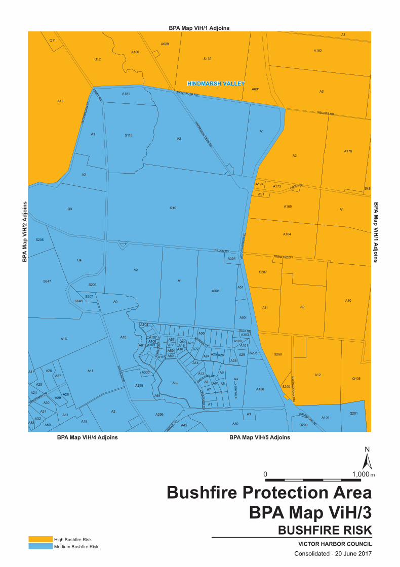
A9
Q4
A16 A10
A81A18A19
A36
A8 A6
A164
A2
A33A32
A2
A59
A58
A3
S298
A24
A31
S648
Q3
A2
A181
S116
A107
A51
A29
A303
A50
Q405
A1
A173
A165
Q201
A3
A178
Q11
A30
A13
A300
A109
A60
A12
A2
S287
S299
Q200
S207
A1
A11
A9
A298
A629
A14
A25
A174
A30
A10
A17
S205
A29A28
S206
A2
A19
A51
A108
A100
A20
A1
A45
A22
A24
A1
A5
A301
S132
S295
A130
A12
A182
A1
A1
A50
A27
A116
A57
A62
A26A28
A304
A4
A100
A631
A11
S48
A25
A26
S647
Q12
A104
A299
A64
A21
A7
Q10
A101
A91
A2
A101
WEL
CH RD
VIC
TOR
HAR
BO
R R
D
SQUIRES RD
GLEN RD
BAMBRICK RD
PANORAMA DR
WATERPORT RD
VIRGIN RD
ARABIAN CT
WAG
GO
N R
D
HINDMARSH
TIERS RD
MONT ROSA RD
DILLON RD
HU
TCH
INSO
N R
D
SHETLAND CT
APPA
LOO
SA
DR
LIPIZZAN
ER
DR
NA
NG
AWO
OK
A TR
K
STI
RLI
NG
CT
KENNY RD
HINDMARSH VALLEY
BUSHFIRE RISKVICTOR HARBOR COUNCIL
Bushfire Protection AreaBPA Map ViH/3
High Bushfire RiskMedium Bushfire Risk
BPA Map ViH/1 AdjoinsBPA Map ViH/1 Adjoins
BPA Map ViH/4 Adjoins BPA Map ViH/5 Adjoins
BPA
Map V
iH/2
Adjoi
ns
0 1,000 m
Consolidated - 20 June 2017

VICTOR HARBOR
LOWER INMAN VALLEY
BACK VALLEY
WAITPINGA
HINDMARSH VALLEY
ENCOUNTER BAY
DAY R
D
ARM
STRO
NGRD
INMAN VALLEY RD
CANT
ERBU
RYRD
STOCK RD
CARTWRIGHT
RD
CROZIER RD
OZONE S
T
GEORGE MAIN RD
MILL RD
BAY RD
SWAIN
SCROSSING RD
GREENHILL
SRD
BAC
CH
US
RD
GLENVALE RD
OVAL
RD
VICTORIA ST
PAG
ES R
D
CAN
TON
PL
FULL
ERW
EST
RD
ESPLANADE
MAUDE ST
WILL
IAM S
T
HENDE RSON RD
FINNISS RD
LINDSAY ST
BA UDIN RD
GLASSENBU
RY
DR
SURREY AV
PRIME
BV
D
SEAVIEW RD
JASM
INDR
WAG
GON RD
FERR
IER
DR
STURT ST
WAT
TLE
BU
RY
RD
SWAIN RD
SOM
ERS
RD
GALPIN AV
HILL ST
JAMES AV
SPR
ING
RD
DENE AV
EWEN TCE
GRAHAM ST
HOLD
ER R
D
CLYDESDA
LED
R
NEWLAND ST
LEWORTHY ST
BRODERICK TCE
POLTONG CRWARNE ST
FULLER EAST RD
PHILIP AV
TUDOR
AV
GARE CT
WAR
LAND
AV
HAW
KE R
D
THORN
E TC
E
O'LEARY ST
ZILMCT
BRO
OKRD
LAWSON STSTOCKRIDGE RD
CORNHILL RD
KINGSFORD ST
DWIAR RD
R IVER RD CHURCHILL RD
KU LLAROO RD
MAYFIELD TCE
WATER
RESER
VERD
ANG
LES
EAR
DJENKINS AV
ALTMAN AV
WIS
HART
CR
COLE
BATC
HRD
WAT
SONRD
INM
AN ST
SHIELDS CR
TRIPP ST
JAC
KSON RD
MARTHA CL
KAY
CT
EDZE
LL R
D
SINKINSON RD
ALMOND AV
HIN
KL
ER ST
SCAR
LE
TT CT
HARVEY AV
ME
YER
ST
OV
AL
PARKRD
BLISS CT
ENTERPRISE AV
PAG
ES
RD
AA1
AA2
AA50
AA150
AA51
SS696
QQ52
AA19
AA30
AA21
AA24
SS732AA101
SS656
AA5
AA55
AA662
AA97
QQ50
AA96
AA57
AA494
AA100
AA4
AA56
AA52
AA3
AA493
AA70
AA332
AA45
AA60
AA18
AA23
AA503
SS460
AA47
SS527
AA6
SS487
AA10
SS453
SS522
SS479
AA20
SS769
AA8
AA7
AA650AA9
AA148
AA22
SS731
AA46
AA36
SS496
AA38
AA11AA61
AA40
AA625
AA104
AA13
AA41
SS445
AA78
SS488
AA12
SS441
AA15
AA16
AA17
AA37
AA703
AA14
SS464
AA28
AA26
AA31
SS801
SS477
AA34
AA65
AA27
AA29
AA152
SS491
SS442
AA111
AA81
AA33
AA201SS663
AA63
AA84
SS502
AA58
AA82
AA83
AA72AA194
AA193
AA501
SS726
BUSHFIRE RISKVICTOR HARBOR COUNCIL
Bushfire Protection AreaBPA Map ViH/4
Excluded area from bushfire protectionplanning provisions or Medium bushfire risk subject to the requirements of the Suburban Neighbourhood zone
Medium Bushfire RiskHigh Bushfire Risk
Excluded area from bushfire protection planning provisions
Development Plan Boundary
APB
V paM
HiA 1/
djsnio
BPA Map ViH/3 AdjoinsBPA Map ViH/2 Adjoins
BPA Map ViH/6 Adjoins
sniojdA 2/
HiV paM AP
BP
BA
aM
pHi
V/5
Adj
i ons
000,10 m
Consolidated - 20 June 2017

Q503
S557
S542
S763
A699
A3
A21
A95
S767
A1
A234
A131
A31
A2
S733
S761
A11A50
A200
A81
A7
A32
A20
A55
A59
A40
A295
A3
A303
Q201
A782
A14
A12
A21
Q501
A57
A56
S531
A5
A1
A21
A1161
A100
Q200
A6
A11
A22
A5
A100
A30
Q1166
A103
Q202 S87
A69
A10
A440
A404
S530
A6
A14
A158
A45
A15
A62
A304
A9 A58
S760
A54
S543
A4
S736
A5
A3
A157
A16
Q500
A103
A2
S558
A10
A270
A101
A637
A2
A501
A1010
A2030A500
A403
A101 Q405
A4
A200
Q502
BRI D
GE
TCE
HONEYMAN GR
MISS
EN
AV
ACRA
MAN
ST
ALBATROSS AVPORT ELLIOT RD
SUN O
RCHID DR
SELLS
ST
CORAL ST
AD
ELAID
E R
D
AGNES GILLESPIE
DR
SUTHERLAND AV
HIN
DM
ARSH
RD
AFRIC
AINE
DR
SINC
LAIR
S T
YAN
DR
A TC
E
ALBERT
PL
EMER
ALD
DRCOROMANDEL DR
CUDMORE RD
VICTORIA ST
FIRS
T AV
BOUCAUT CR
NO
RFO
LK AV
GRANTLEY AV
PINE AV
KLEINIG DR
RENOWN AV
ADARE AV
COWAN
AV
LINC
OLN
PAR
K D
R
ALE
XAN
DE
R ST
COLEMAN AV
GRANITE
ISLAND RD
RO
SETTA
AV
ANTRIM ST
DONEGAL ST
MCDONALD ST
PEACE AV
GUM
AV
AQ UAMARINE BVD
THE DRIVE
CARLYLE
ST
SEAGULL AV
OC
EA
N R
D
ESPLANADE
DRAGONFLY BVD
LAMONT
RD
RUPARA AV
MO
DRA
ST
SEAVIEW RD
NE
WELL
ST
DINAN RD
OSTEND CR
BLUFFVIEW RD
DAVID ST
HILL ST
DOWN
ST
TYR
ON
E S
T
THE CRESCENT
FOU
RTH
AV
FIELD
AVRIV
ERVIEW
RD
RAPID RD
SANDGATE GR
CORNHILL RD
THIR
D AV
LI NC
OLN
RD
ADAMSON ST
MAN
LY G
R
BRAND AV
NA
RIN
NA
AV
DUNDALK AV
HIGH
ST
DROMANA PDE
ELLIO
T AV
WATERPORT RD
WA
LKER ST
HEGGERTON ST
YATES AV
CHERINGTON RD
SEYMOUR LANE
COMMERCE CR
BRECKAN AV
MA
RC
H
AV
MC
KI N
L A Y ST
ST
KILDA ST
VIEW RD
HAYWARD CT
STRAWBERRY HILL RD
BOND AV
MCCRACKEN DR
AC
ACIA RD
BASHAM
RD
LANGLEY RD
VALLEY VIEW RD
KA
U RN A AV
PEROOMBA TCE
H AYWARD ST
OLIVER PDE
FULL
ER EA
ST RD
WAGGON RD
TORR
ENS
ST
MENTONE RD
WATTLE
DR
CROZIER RD
FAI RWAY DR
HEY
SEN
PD
E
LAXT
ON ST
RAPID DR
STUA
RT S
T
WAR
LAND
A V
FLIN
DE
RS
PDE
OC
EA
N S
T
TRADE CT
Land Not Withina Council Area
(Coastal Waters)
AlexandrinaCouncil
HAYBOROUGH
VICTORHARBOR
HINDMARSH VALLEY
MCCRACKEN
PORTELLIOT
Police Point
Chiton RocksDump Beach
VictorHarbor
BUSHFIRE RISKVICTOR HARBOR COUNCIL
Bushfire Protection AreaBPA Map ViH/5
High Bushfire RiskMedium Bushfire RiskExcluded area from bushfire protection planning provisionsDevelopment Plan Boundary
BPA Map ViH/1 Adjoins
BPA Map ViH/1 Adjoins
BPA Map ViH/1 AdjoinsBPA Map ViH/3 Adjoins
BPA
Map V
iH/4
Adjoi
ns
0 1,000 m
Consolidated - 20 June 2017

ENCOUNTER BAY
WAITPINGAVICTOR HARBOR
Land Not Within a Council Area (Coastal Waters)
FRANKLIN
PDE
BAY RD
BATTYE RD
JAGGER RDW
HALERSRDW
AITP
INGA
RD
TABERNACLE RD
MIL
L RD
DODS
ON
RD
THR
EE
GU
LLIE
S R
D
KENT
DR
BARTEL BVD
JOYST
KIN
GS
BEA
CH
RD
FELLST
VICTOR AV
MALEN AV
NEVIN AV
TUGWELL RD
WHITE CRHOPE ST
GILES ST
SOLWAY CR
MAT
THE
WFL
INDE
RSDR
RU
MBE
LOW
S T
NICOLA
S BAUDIN
DR
CLIVE AV GEORGEST
LAURIEAV
HIGGINSST
SWEETMAN AV
RUSSELL ST
HARBOUR
VIEWTC
E
CLAIRAV
PETR
ELAV
BUTLER RISE
FERRIE
RDR
CAKEBREAD RD
WHI
TE C
L
BLUFF CR
GIBSON AV
DAVIE S S T
WR
IGHT
TCE
NO RMA
CR
MINKE WHALE DR
KIR
BYST
LORD
HOBA
RT
CR
VIK
ING
ST
FOUNTAIN AV
MAU
DE
ST
ISLANDERDR
BUFFALO C T
BOLGER WAY
ENCOUNTE
R TCE
RIDGE
AVM
ARLIN TCE
ROSEMARY CT
CLIPPER CT
PARK AV
STO
NE H
UT C
CTM
ILLA
RDCT
TWIN FIGS CT
AINSLIE
ROBERTSDR
HUMP BACKRD
WALLAGE CT
SHA
NN
ON
ST
MOLLIEN AV
LAKESID
E CCT
PASS
ATT ST
HODGE AV
DOLPHIN AV
OLIV
EBA
NK
CR
SEAC
RE
ST AV
COORONGC
R
MAYFLOWE RCT
MINNAMOORA CT
CYGNET CT
HENRY ST
MANNING AV
POLLARD CT
ALLEN ST
CHAPEL STH
ART
AV
INVE
STIGA
TOR
CR
KRI LL CT
THEISEN GER CT
SMITH
ST
HORIZON WAY
PERVAN ST
OY
STE
RAV
ORCA PL
EDD
YC
T
BAYVIEWGR
MICHAEL ST
BEVERLEY GR
BALE
EN CT
FLUKE
CT
ROBBST
POO
LE A
V
DALBLAIR CT
BAY RD
SS3
AA2AA1000
AA346
SS80
AA649
AA6
AA503
AA5
AA301
AA1
AA40
AA508
AA650
AA21
AA7
AA14
AA347
AA10
AA16
AA50
AA101
AA100
AA17
AA102
AA15
AA39
SS723
AA231
AA4
AA122
AA38
AA20
BUSHFIRE RISKVICTOR HARBOR COUNCIL
Bushfire Protection AreaBPA Map ViH/6
BPA Map ViH/1 Adjoins
PB
Aa
M p
HiV
/1A
dji ons
BPA Map ViH/4 Adjoinssniojd
A 7/HiV pa
M APB
000,10 m
Excluded area from bushfire protectionplanning provisions or Medium bushfire risk subject to the requirements of the Suburban Neighbourhood zone
Medium Bushfire RiskHigh Bushfire Risk
Excluded area from bushfire protection planning provisions
Development Plan Boundary
Consolidated - 20 June 2017
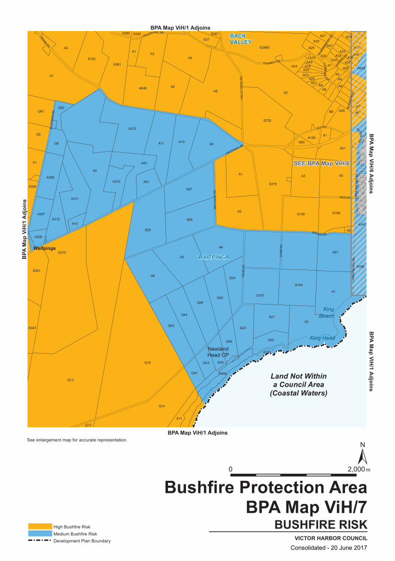
SEE BPA Map ViH/6
S27
Q13
Q91
A10
S722
A9
S380
S37
A16A45
A8
A91
A21
A11
Q46
Q6
A2
A5
Q49
A21A2
A1
A44
S388S
S185
A100
A20
A18
A39
A19
S370
Q14
A304
A2
A315
A50
A51
A5
S387 A27
A31
A5
Q42
S361
Q92
A3
A10
S26
Q45
A1
A3
S167
S164
A21A9
B9
A3
A33
A4
A5
A2
A17
A649
Q44
A100
A1
A305
Q5
A312
A6
A4
A4
S725
A22
A35
A347
A346
Q15 Q43
S400
A308
A311
A1
S381
A310
A1
A3
A28
A37
A50A7
A307
A646
A11
S382
Q50
A22
A23
A1
A2
A1
A34
A36
S188
A38
A6
S347
Q12
Q41
S25
A8
Q24
Q23
S375
Q92
A29
A30
BATTYE R
D
BLO
CK
ERS
RD
TJILBRU
KE
DR
BUTL
ER
RIS
E
HAL
LS C
RE
EK
RD
OLD RD
JAGGER RD
WAITPINGA RD
RANGE RD
TUGWELL RD
THR
EE
GU
LLIE
S R
D
REID RD
WILSON HILL RD
GLASS
ENBU
RY DR
BAU
M R
D
DU
MP
RD
FERR
IER DR
DE
PLE
DG
E R
D
KIN
GS
BEA
CH
RD
Land Not Withina Council Area
(Coastal Waters)
WAITPINGA
BACKVALLEY
NewlandHead CP
King Head
KingBeach
Waitpinga
BUSHFIRE RISKVICTOR HARBOR COUNCIL
Bushfire Protection AreaBPA Map ViH/7
High Bushfire RiskMedium Bushfire RiskDevelopment Plan Boundary
BPA Map ViH/1 Adjoins
BPA Map ViH/1 Adjoins
BPA
Map V
iH/1
Adjoi
nsBPA Map ViH/1 Adjoins
BPA Map ViH/6 Adjoins
0 2,000 m
See enlargement map for accurate representation.
Consolidated - 20 June 2017

Consolidated - 20 June 2017
Error! Unknown document property name. Mapping Section
Concept Plan Maps
425
Concept Plan Maps
Consolidated - 20 June 2017

Consolidated - 20 June 2017
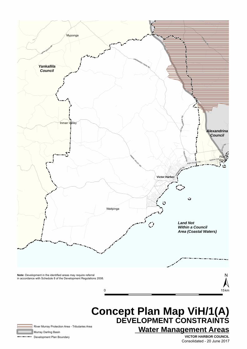
Land NotWithin a CouncilArea (Coastal Waters)
AlexandrinaCouncil
YankallilaCouncil
Myponga
PortElliot
Inman Valley
Waitpinga
Victor HarborV
ICTO
R H
AR
BOR
RD
AD
E LAID E
RD
HIND
MAR
SHRD
PO
RT
ELLI
OT
RD
NORTH TCE
INMAN VALLEY
RD
HINDMARSH TIERS RD
GOO
LWA
RD
MAIN SOUTH
RD
PORT ELLIOT RD
±
VICTOR HARBOR COUNCIL
0 15km
River Murray Protection Area - Tributaries Area
Murray Darling Basin
Development Plan Boundary
Concept Plan Map ViH/1(A)DEVELOPMENT CONSTRAINTS
Water Management Areas
Note: Development in the identified areas may require referralin accordance with Schedule 8 of the Development Regulations 2008.
Consolidated - 20 June 2017

Land NotWithin a CouncilArea (Coastal Waters)
AlexandrinaCouncil
YankallilaCouncil
Myponga
PortElliot
Inman Valley
Waitpinga
Victor Harbor
WesternMount Lofty
Ranges
EasternMount LoftyRanges
VIC
TOR
HA
RBO
R RD
AD
E LAID E
RD
HIND
MAR
SHRD
PO
RT
ELLI
OT
RD
NORTH TCE
INMAN VALLEY
RD
HINDMARSH TIERS RD
GOO
LWA
RD
MAIN SOUTH
RD
PORT ELLIOT RD
±
VICTOR HARBOR COUNCIL
0 15km
Tributaries
Prescribed Water Resource Areas
Development Plan Boundary
Concept Plan Map ViH/1(B)DEVELOPMENT CONSTRAINTS
Water Management Areas
Note: Development in the identified areas may require referralin accordance with Schedule 8 of the Development Regulations 2008.
Mount Lofty Ranges Water Protection Area
Consolidated - 20 June 2017

ESPLANADEESPLANADE
BRIDG
E TCE
BRIDG
E TCE
VICTORIA ST
BURK
E ST
TORR
ENS S
T
HILL ST
CORAL ST
OCEAN ST
CROZIER RD
SEAVIEW RD
FLINDERS PDEFLINDERS PDE
ACRA
MAN ST
ACRA
MAN ST
SouthernOcean
3
3
2
1
1
776
766
CAR PARKING FUND POLICY AREAS
Car Parking Fund Area 1
Car Parking Fund Area 2
Car Parking Fund Area 3
Concept Area Boundary
Development Plan Boundary
±0 100 200 300 400 500 Metres
Concept Plan Map ViH/2VICTOR HARBOR COUNCIL
REGIONAL CENTRE
CAR PARKING FUND AREAS
Consolidated - 20 June 2017
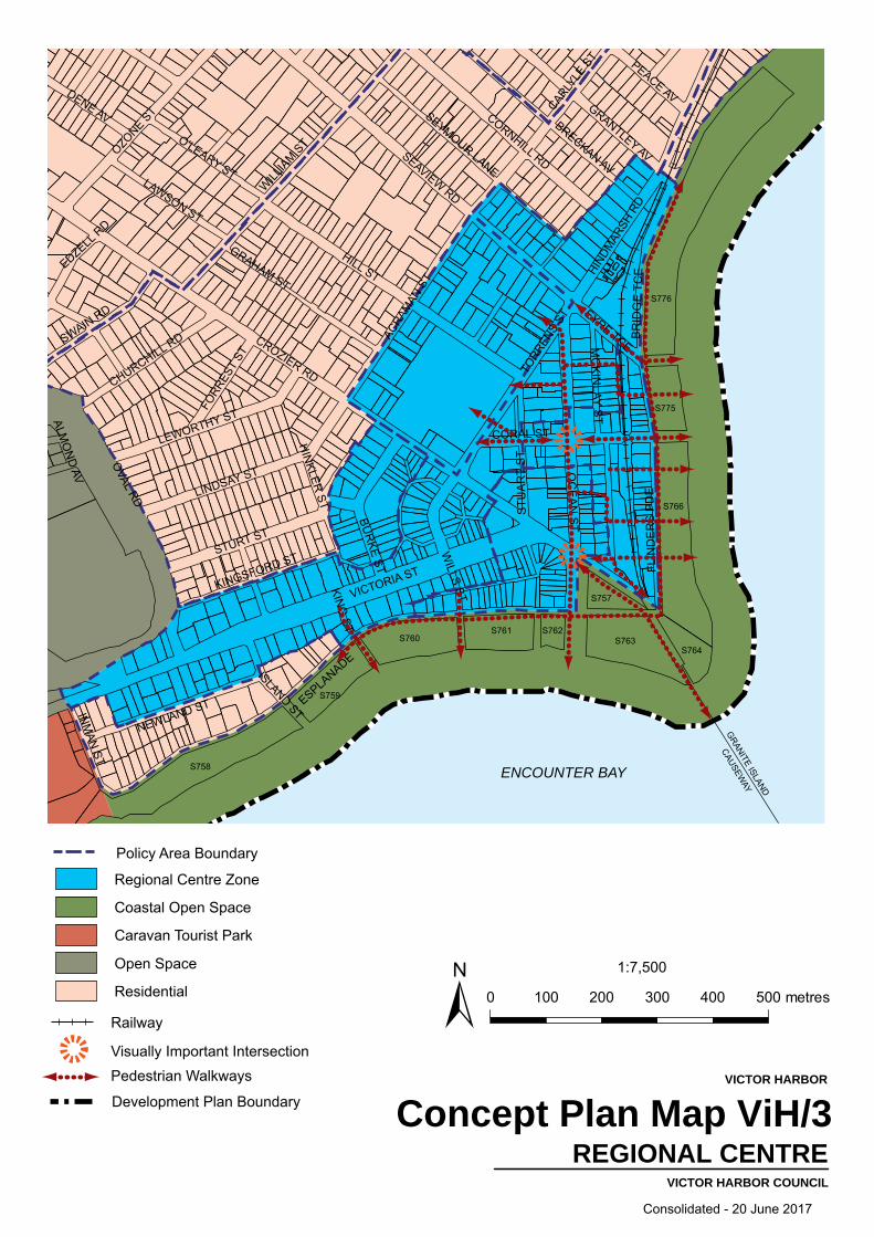
ESPLANADE
CROZIER RD
HILL ST
VICTORIA ST
OVAL RD
SEAVIEW RDWILL
IAM S
T
BR
IDG
E T
CE
OC
EA
N S
T
TORR
ENS
ST
OZONE S
T CORNHILL RD
LINDSAY ST
HIND
MAR
SH R
D
BRECKAN AV
STURT STCARLY
LE S
T
FLIN
DE
RS
PD
E
CORAL ST
ACRA
MAN
ST
GRAHAM ST
SEYMOUR LANE
GRANTLEY AV
BUR
KE ST
LEWORTHY ST
NEWLAND ST
SWAIN RD
O'LEARY STLAWSON ST
STU
AR
T S
T
DENE AV
KINGSFORD ST
CHURCHILL RD
PEACE AV
INM
AN ST
EYRE TCEMC
KIN
LAY STFO
RRES
T ST
EDZELL R
D
ISLAND STH
INKLER
ST
WILLS STKIN
G ST
ALMO
ND
AV
GRANITE ISLAND
CAUSEWAY
ENCOUNTER BAY
Concept Plan Map ViH/3VICTOR HARBOR COUNCIL
VICTOR HARBOR
REGIONAL CENTRE
1:7,500
0 100 200 300 400 500 metres±Railway
Pedestrian WalkwaysVisually Important Intersection
Development Plan Boundary
Policy Area Boundary
Regional Centre Zone
Coastal Open Space
Caravan Tourist Park
Open Space
Residential
S763
S757
S762S761S760
S758
S759
S764
S766
S775
S776
Consolidated - 20 June 2017

ESPLANADE
OC
EA
N S
T
CORAL ST
FLIN
DE
RS
PD
E
TORR
ENS
ST
CROZIER RD
STU
AR
T ST
VICTORIA ST RAILWAY TCE
MC
KIN
LAY ST
ALBERT PL
ENCOUNTER BAY
GRANIT ISLAND CASUEW
AY
Concept Plan Map ViH/4VICTOR HARBOR COUNCIL
REGIONAL CENTRE
WARLAND RESERVE & SURROUNDS
1:5,000
0 50 100 150 200 250 metres±Railways
Development Plan Boundary
Regional Centre
Coastal Open Space
Warland Reserve
Consolidated - 20 June 2017
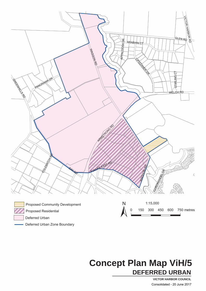
DAY RD
WELCH RD
WAG
GO
N R
D
ARMSTRONG RD
GREENHILLS RD
ARABIAN CT
LIPIZZANER DR
FULLER EAST RD
PANORAMA DR
VICTO
R H
ARBO
R R
D
CORO
MAN
DEL
DR
GLEN RD
STI
RLI
NG
CT
APPA
LOO
SA D
R
COLE
BATC
H RD
WAG
GO
N R
D
Concept Plan Map ViH/5VICTOR HARBOR COUNCIL
DEFERRED URBAN
1:15,000
0 150 300 450 600 750 metres±Deferred Urban
Deferred Urban Zone Boundary
Proposed Community Development
Proposed Residential
Consolidated - 20 June 2017

K
B
A
C
DE
G
H
JI
F
SouthernOcean
TORR
ENS
ST
TORR
ENS
ST
EYRE TCE
EYRE TCE
ESPLANADEESPLANADE
BURK
E ST
BURK
E ST
VICTORIA ST VICTORIA ST
ACRA
MAN S
T
ACRA
MAN S
THILL STHILL ST
HILL STHILL ST
SEAVIEW RD
SEAVIEW RD
HINDM
ARSH
RD
HINDM
ARSH
RD
FLINDERS PDEFLINDERS PDE
BRIDG
E TCE
BRIDG
E TCE
ALBERT PLALBERT PL
CROZIER RD
CROZIER RD
MCKINLAY STMCKINLAY ST
CORAL STCORAL ST
OCEAN STOCEAN ST
776
766
±0 200 Metres
Scale 1:5000
Concept Plan Map ViH/6VICTOR HARBOR COUNCIL
REGIONAL CENTRE
LANDMARK DEVELOPMENT SITES
Landmark Sites
Active Street Frontages
Proposed Decked carpark
Policy Area Boundary
Development Plan Boundary
A
NOTE: Detailed diagrams are provided for each Landmark Development site within the Zone policy, except for ‘H”, ‘I’ and ‘J’
Consolidated - 20 June 2017

BAY RD
MALEN AV
HARBOUR VIEW TCE
KENT D
R
CENTRAL DR
PHILIP AV
MAU
DE ST
SMITH
ST
TREGONNING ST
STRATHMORE CT
GIBSON AV
CLIFTON WY
MATTHEW FLINDERS DR
7.06
8.11
9.17
10.2
211
.27
12.3
213
.37
14.4
215
.47
16.5
217
.57
18.6
318
.63
20.7
321
.78
22.8
323
.83
25.9
825
.98
27.0
328
.08
29.1
430
.19
31.2
432
.29
33.3
434
.39
35.4
436
.49
37.5
4
3.91
0020406080100
120
140
160
180
200
220
240
260
280
300
320
4.69
6.01
BEARING 139º24’14”
BEARING 313º51’10”
HELIPAD
HORIZONTAL DISTANCE (METRES) FROM EDGE OF HELIPAD
MA
X. B
UIL
DIN
G H
EIG
HT
(ME
TRE
S A
HD
)
Concept Plan Map ViH/7
VICTOR HARBOR COUNCIL
VICTOR HARBOR
DISTRICT HOSPITAL HELIPADFLIGHT PATH & HEIGHT RESTRICTIONS
Helipad
Height Limits
Flight Path Boundary
Tree
Proposed Land Division
1:3,400
0 50 100 150 200 250 metres
±
Consolidated - 20 June 2017
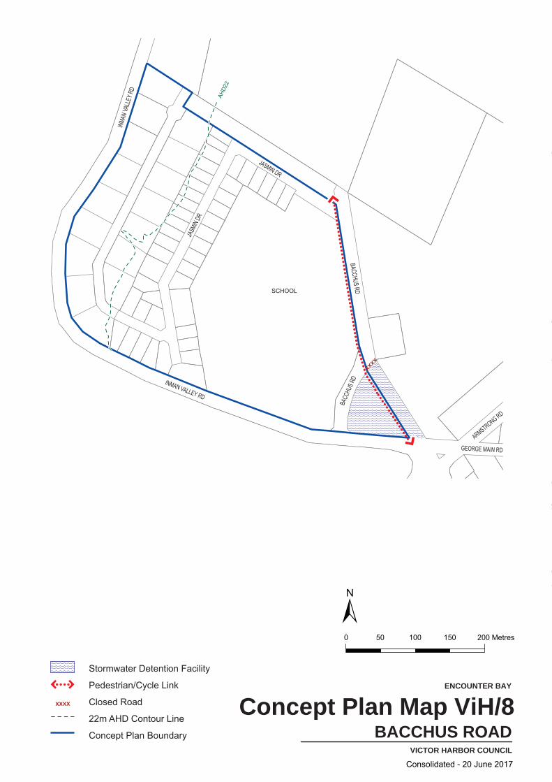
INMA
N VA
LLEY
RD
INMAN VALLEY RD
MILL RD
BACCHUS RD
BACC
HUS R
D
JASMIN DR
JASM
IN DR
POLTONG CRWISHART CR
MAUDE ST
RYMILL AV
TRIPP ST
ARMSTRONG RD
GEORGE MAIN RD
SAN REM
O CT
xxxx
SCHOOL
AHD2
2
ENCOUNTER BAY
±0 50 100 150 200 Metres
Concept Plan Map ViH/8VICTOR HARBOR COUNCIL
BACCHUS ROAD
Stormwater Detention Facility
Pedestrian/Cycle Link
Closed Road
22m AHD Contour Line
Concept Plan Boundary
xxxx
Consolidated - 20 June 2017

RESERVE
40 50
60
30
3020
40
40
50
5060
708090
110120
130
140150
160
20
708090
100
10010
0
STOCK RD
INMAN
RIV
ER
SPR
ING
RD
CLYD
ESDA
LE D
R
STOCKRIDGE RD
BROOK
RD
WAT
SON R
D
Concept Plan Map ViH/9VICTOR HARBOR COUNCIL
CROZIER HILL
RURAL LIVING
1:10,0000 100 200 300 400 500 metres±
Contour interval 10m
110m Contour (AHD)
WaterCourses
Policy Area Boundary
Approximate Extent of 100 ARI Flood (Conceptual only)
Open Space
Reserve
Primary Production
Rural Living
Consolidated - 20 June 2017

WELCH RD
WAGGON RD
AD
ELA
IDE
RD
COROMANDEL DR
Ridgeline RoadFU
LLER
EAS
T RD
ARMSTRONG RD
FAIRWAY DR
LIP
IZZA
NE
R D
R
BANKSIA LANE
BASHAMS RD
LINKS CT
WAGGON RD
RIVER
HINDMARSH
NCe
Concept Plan Map ViH/10VICTOR HARBOR COUNCIL
HINDMARSH VALLEY
1:10,000
0 100 200 300 400 500 metres
±Water Courses
Landscape Buffer (30m)
Large Trees in Road Reserve
Minor Vehicular Link
Proposed Road
River Crossing
Medium Density Residential Areas
Proposed Community Development
Deferred Urban
Open Space
Primary Production
Residential
Rural Living
Pedestrian/Bicycle Link
Stormwater Management Areas
Neighbourhood Centre
Recreation/Conservation/Open Space Areas
SS
NCe
SSSS
SS
SS
Consolidated - 20 June 2017

RuL1
Rec
HIn
LIn
LIn
TA(IR)
CTP
R
MU
CANT
ERBU
RY R
D
ARMSTRONG RD
GEORGE MAIN RD
EWEN TCE
Emergency Services
Concept Plan Map ViH/11VICTOR HARBOR COUNCIL
MIXED USE VICTOR HARBOR
±Zone Boundary
Concept Plan Boundary
Emergency Services Precinct
Vehicle Access
Open Space
0 50 100 150 200 250 m1:4,000
Mixed Use Zone
Consolidated - 20 June 2017

C
NCe
R
ADELAID
E RD
MAR
CH
AVE
SELLS ST
AGNES GILLESPIE DR
Concept Plan Map ViH/12VICTOR HARBOR COUNCIL
NEIGHBOURHOOD CENTRE
HAYBOROUGH
0 20 40 60 80 100 m
Potential Residential/Tourist Accommodation
Neighbourhood Centre
Zone Boundary
Potential Vehicle Access
Potential Pedestrian Path
Vegetation/Landscaping
Concept Plan Boundary
±
Consolidated - 20 June 2017
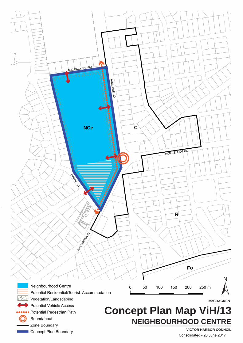
CNCe
Fo
R
PORT ELLIOT RD
McCRACKEN DR
DOWN ST
ADELAID
E RD
HIND
MAR
SH R
D
Concept Plan Map ViH/13VICTOR HARBOR COUNCIL
NEIGHBOURHOOD CENTRE
McCRACKEN
Neighbourhood CentrePotential Residential/Tourist AccommodationVegetation/LandscapingPotential Vehicle AccessPotential Pedestrian PathRoundaboutZone BoundaryConcept Plan Boundary
±0 50 100 150 200 250 m
Consolidated - 20 June 2017

TABERNACLE RD
INMAN VALLEY RD
WAI
TPIN
GA R
D
BAY RD
MIL
L RD
GF
GF Rec
RuL2
LIn
RP
SN
R
115115
110
110
105
105
105
100
100
100
959595 909090 858585 808080 757575
707070 656565 606060 555555
105
105
105
100
100
100
959595909090
858585 808080 757575
151515151515
202020
252525
303030
3535354040454545
505050
757575808080
858585
909090959595
100
100
100
125125125
120120120
101010101010
NCe
Concept Plan Map ViH/14VICTOR HARBOR COUNCIL
SUBURBAN NEIGHBOURHOOD
Neighbourhood Activity CentreSuburban Neighourhood ZoneLow Density ResidentialOpen Space/LandscapingExisting Mine TenementPotential Mineral ResourcePotential Vehicle AccessConcept Plan Boundary
ContoursZone Boundary ±0 100 200 300 400 500 m
1:10,000NCe
ENCOUNTER BAY
Consolidated - 20 June 2017


![Port Lincoln Council Development Plan - DPTI...– [18 October 2012] Section 29(2)(c) Amendment – [29 November 2012] 4 July 2013 Car Parking DPA – 4 July 2013 24 October 2013 Industry,](https://static.fdocuments.in/doc/165x107/5f2d2154cff25a169b3d7ade/port-lincoln-council-development-plan-dpti-a-18-october-2012-section-292c.jpg)