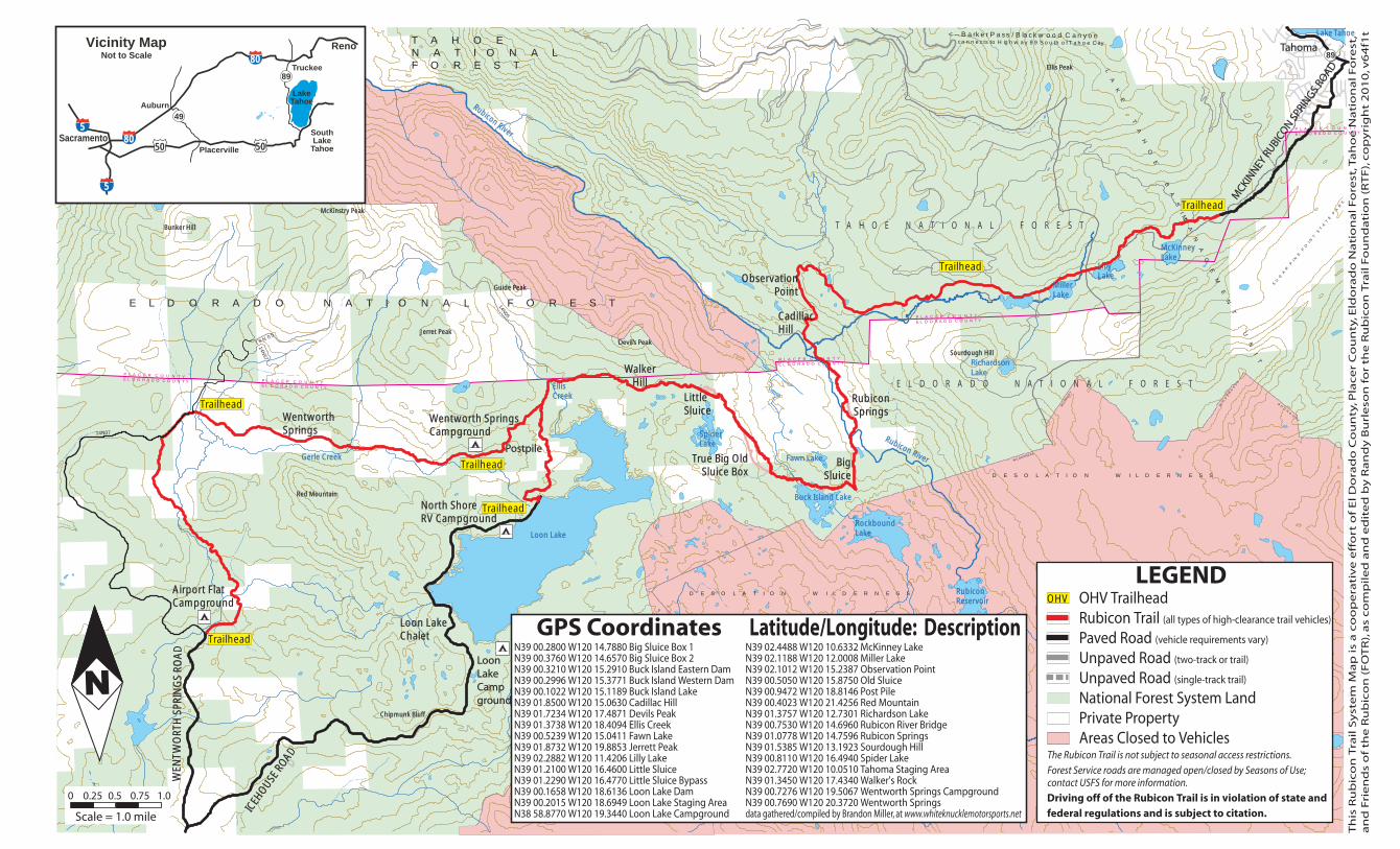
Vicinity Map Reno TahomaTahoma This Rubicon Trail … Rubicon Trail System Map is a cooperative...
1
� � � � � � � � � � � � � � � � � � � � � � � � � � � � � � � � � � � � � � � � � � � � � � � � � � � � � � � � � � � � � � � � � � � � � � � � � � � � � � � � � � � � � � � � � � � � � � � � � � � � � � � � � � � � � � � � � � � � � � � � � � � � � � � � � � ��� ������� ��� � ���� � � � � � � � � � � � � � � � � �� This Rubicon Trail System Map is a cooperative effort of El Dorado County, Placer County, Eldorado National Forest, Tahoe National Forest, and Friends of the Rubicon (FOTR), as compiled and edited by Randy Burleson for the Rubicon Trail Foundation (RTF), copyright 2010, v64f1t � � � � � � � � � � � � � � � � � � � � � � � � � � � � � � � � � � � � � � � � � � � � � � � � � � � � � � � � � � � � � � � � � � � � � � � � � � � � � � � � � � E L D O R A D O N A T I O N A L F O R E S T T A H O E N A T I O N A L F O R E S T � � � � � � � � � � � � � � � � � � � � � � � � � � � � � � � � � � � � � � � � � � � � � � � � � � � � � � � � � � � � � � � � � � � � � � ����� ����� ����� � � � � � 89 � �� � � �� � � � � �� � � �� � � � �� � � � � � � � � � �� � � �� �� � �� � � � � � � � � � �� � � � � � � � � ��� � ���� ���� � � �� � �� � � � �� � � � �� � � � � � � � � � � ���� � ���� � � � � � � � � Richardson Richardson Lake Lake � ���� � ���� � � � � � � � � � � � � ��� � ��� � � � � � � � � � � � � � � � � � � � � � � � � � � � � � � � � � � � � � Fawn Lake Fawn Lake � � � �� � � �� � � � � � � �� �� � � � � � � � �� � � �� � � � � � � �� �� � � � � � � � � � � � � �� �� � � � � � � �� � � � � � � � � � � � � � � � � � � � � � � � � � � � � � � � �� � � �� � � � � � � � � � � � � � � � �� � �� � � � � � �� � �� � � �� � �� � � � � � � �� � � � �� � � � � � � � � � � � � � � � �� � � � �� � � � � � � � � � � � � � � � � � � � � � � � � � � � � � � � � � � � � ��� � � � ��� � � � � � � � � � � � � � � � �� � � �� Devil’s Peak Devil’s Peak � � � � � � � � � � � � � ��� � � � � � � ��� Ellis Peak Ellis Peak � � ��� � � ��� � � � � � � � � � �� � � � � � � �� � � � � � �� �� �� �� Loon Loon Lake Lake Camp Camp ground ground � � � � � � � � � � � � � � � � � � � � � � � � � � � � � � � � � � � � � � � � � � � � � � � � � � � � � � � � � � � � � � �� � � �� � � � � � � � � � � � � � � � � � � � � � � �� �� � � � � � � � � � �� �� � � � � � � � � � � � � � � � � � � � � � � � � � � � � � � � � � � � � �� � � � �� � � � � � � � � � � � � � � � � � � � � � �� � � �� � � Postpile Postpile � � �� � �� � � � � � ��� � ��� � ��� �� � ��� �� � �� �� �� �� � � � � � � � � � �� � �� � �� �� � �� �� �� �� � � � � � � � �� �� � �� �� �� �� � � � � �� � � �� � � � � � � � � � �� � � �� � � � � � ���� � � � ���� � � ��� � ��� � � � � � � � � � � � � �� � � �� � � � �� � �� � Tahoma Tahoma � � � � � � � � � � � � � � � � � � � � � � � MCKINNEY RUBICON SPRINGS ROAD MCKINNEY RUBICON SPRINGS ROAD � � � � � � � � � � � � � � � � � � � � � � � � � � � � � � � � � � � � � � � LEGEND OHV Trailhead Rubicon Trail (all types of high-clearance trail vehicles) Paved Road (vehicle requirements vary) Unpaved Road (two-track or trail) Unpaved Road (single-track trail) National Forest System Land Private Property Areas Closed to Vehicles The Rubicon Trail is not subject to seasonal access restrictions. Forest Service roads are managed open/closed by Seasons of Use; contact USFS for more information. Driving off of the Rubicon Trail is in violation of state and federal regulations and is subject to citation. � � � GPS Coordinates N39 00.2800 W120 14.7880 Big Sluice Box 1 N39 00.3760 W120 14.6570 Big Sluice Box 2 N39 00.3210 W120 15.2910 Buck Island Eastern Dam N39 00.2996 W120 15.3771 Buck Island Western Dam N39 00.1022 W120 15.1189 Buck Island Lake N39 01.8500 W120 15.0630 Cadillac Hill N39 01.7234 W120 17.4871 Devils Peak N39 01.3738 W120 18.4094 Ellis Creek N39 00.5239 W120 15.0411 Fawn Lake N39 01.8732 W120 19.8853 Jerrett Peak N39 02.2882 W120 11.4206 Lilly Lake N39 01.2100 W120 16.4600 Little Sluice N39 01.2290 W120 16.4770 Little Sluice Bypass N39 00.1658 W120 18.6136 Loon Lake Dam N39 00.2015 W120 18.6949 Loon Lake Staging Area N38 58.8770 W120 19.3440 Loon Lake Campground Latitude/Longitude: Description N39 02.4488 W120 10.6332 McKinney Lake N39 02.1188 W120 12.0008 Miller Lake N39 02.1012 W120 15.2387 Observation Point N39 00.5050 W120 15.8750 Old Sluice N39 00.9472 W120 18.8146 Post Pile N39 00.4023 W120 21.4256 Red Mountain N39 01.3757 W120 12.7301 Richardson Lake N39 00.7530 W120 14.6960 Rubicon River Bridge N39 01.0778 W120 14.7596 Rubicon Springs N39 01.5385 W120 13.1923 Sourdough Hill N39 00.8110 W120 16.4940 Spider Lake N39 02.7720 W120 10.0510 Tahoma Staging Area N39 01.3450 W120 17.4340 Walker's Rock N39 00.7276 W120 19.5067 Wentworth Springs Campground N39 00.7690 W120 20.3720 Wentworth Springs data gathered/compiled by Brandon Miller, at www.whiteknucklemotorsports.net � � � ��� � � � � � � ��� � � � � � � ��� � � � � � � ��� � � � � � � ��� � � � � � � ��� � � � Reno Lake Tahoe South Lake Tahoe Auburn Placerville Truckee Sacramento Vicinity Map Not to Scale � � � � � � � � � � � � � � � � � � 49 89 1.0 0.75 0.5 0.25 0 Scale = 1.0 mile
Transcript of Vicinity Map Reno TahomaTahoma This Rubicon Trail … Rubicon Trail System Map is a cooperative...
� � � � � � � � � � � � �
� � �� � � � � � �� � � � � �
� � � � � � � � � � � � �
� � �� � � � � � �� � � � � �
� � � � � � � � � � � � �
� � �� � � � � � �� � � � � �
� � � � � � � � � � � � �� � �� � � � � � �� � � � � �
� � � � � � � � � � � � �� � �� � � � � � �� � � � � �
� ���� ��� ��
��
��
��
��
��
��
��
��
���
��
��
��
�
Th
is R
ub
ico
n T
rail
Sy
ste
m M
ap
is
a c
oo
pe
rati
ve
eff
ort
of
El
Do
rad
o C
ou
nty
, Pla
ce
r C
ou
nty
, Eld
ora
do
Na
tio
na
l F
ore
st, T
ah
oe
Na
tio
na
l F
ore
st,
an
d F
rie
nd
s o
f th
e R
ub
ico
n (
FO
TR
), a
s c
om
pil
ed
an
d e
dit
ed
by
Ra
nd
y B
url
eso
n f
or
the
Ru
bic
on
Tra
il F
ou
nd
ati
on
(R
TF
), c
op
yri
gh
t 2
01
0, v
64
f1t
� � � � � � � � � � � � � � � � � � � � � � �
� � � � � � � � � � � � � � � � � � � � � � �
� � � � � � � � � � � � � � � � � � � � � � �
� � � � � � � � � � � � � � � � � � � � � � � � � �
E L D O R A D O N A T I O N A L F O R E S T
T A H O E N A T I O N A L F O R E S T
��
��
��
��
��
��
��
��
��
��
��
��
��
��
��
��
��
��
��
��
�� �
� ��
� ��
� ��
� ��
��
�� �
��
�
� � � � �� � � � � � � �� � � � � �
�����
�����
�����
� � � � �
89
� ���� � �� � ��� � �� ���� �� � � � � � � �� � � � � ���������� � � � � � �� ��� �� �� � � � � �� � �� � � �� �� ��� � � � � �� ���
�� ���������� �� � � �� � �
�� � �� � �� �� � �� � �� � � ��
�� ���� ����� �� � �� � � ��
Richardson Richardson LakeLake
� ����� ����� � �� � � ��
�� � �� � �� � ��� � � ��� � �� � � ��
� � �� � � � �� ��� � � �� � � ��
�� �� � � �� � �� � �� � � ��
Fawn LakeFawn Lake
�� � � ��� � �� � � ��
� � �� ���� � �� �
�� � � ��� � �� � � ��
� � �� ���� � �� �
�� � � � ��� � � ��� �� � � �� � �� �� � � �� � � ��
�� �� � �� � �� � � � �� � � �� � �� � � ��
�� � � ��� � �� � �� ��� � � � �� � � � �� � ��� ��
�� � �� � �� ���� �� �� � � �� � �
�� � �� � �� � � ��� � � � � ��� �� � � �� � �
�� � �� � ��� �� � �� � � �� � �
�� � �� � �� � � ��� � �� � � �� � �
�� � � �� � � � � �� ���� � �� ���
�� � � ��� � �� � � �� � � � � ��� � ��
Devil’s PeakDevil’s Peak
�� � � �� � � � � � � � �� ���� � � � � �� ���
Ellis PeakEllis Peak
�� � ��� ��� ��� �� � � �� � �
�� � �� � � � � ��� �� � � � � �� �� � ��� � �
LoonLoonLakeLakeCampCampgroundground
�� � �� � � � ��� � �� � � �� � � ���� � ��� �� � � �� � � � �� � � � � �� � � �
�� � �� � �� �� � �� � � � ��� � �� � �� � �� � � ��� � � ��� � � �� � � � �� � � � � �� � � �
�� ���� �� � �� � � ��� �� ���� ���� � � �� � � � �� � � � � �� � � �
�� �� � � �� � �� � �� � � ���� � � �� �� � �� �
�� � �� � �� �� � �� � � �� ��� � �� � �� � � ��� � � �
PostpilePostpile
�� � ��� �� � �� �� ���� ���
� �� � ��� �� � ���� �� ���� �� � �� �
�� �� � � ��� � �� �� ���� �� ������ �� ���� �� � ��� �� �� ��
�� �� ��� ��� �� ���� �� ��
�� � � ��� � �� � � �� � ��� � �� � �� � ��� � �
�� � � ���� � �� � ���� � �� ���� ���
�� � � � �� � � � �� �� � �� � �� �� � ��� � ��� �� ��
TahomaTahoma
��� �
�� � �
��
��� �
�� � �
���� � �� �
MCKIN
NEY R
UBICO
N SPR
INGS
ROAD
MCKIN
NEY R
UBICO
N SPR
INGS
ROAD
�� �
��
� �� �
��
��
�� �
��� �
���
� ��
� ���
� ���
�� �
���
��
��
LEGEND OHV Trailhead Rubicon Trail (all types of high-clearance trail vehicles)
Paved Road (vehicle requirements vary)
Unpaved Road (two-track or trail)
Unpaved Road (single-track trail)
National Forest System Land Private Property Areas Closed to Vehicles The Rubicon Trail is not subject to seasonal access restrictions.
Forest Service roads are managed open/closed by Seasons of Use; contact USFS for more information.
Driving off of the Rubicon Trail is in violation of state and federal regulations and is subject to citation.
� � �
GPS CoordinatesN39 00.2800 W120 14.7880 Big Sluice Box 1 N39 00.3760 W120 14.6570 Big Sluice Box 2 N39 00.3210 W120 15.2910 Buck Island Eastern Dam N39 00.2996 W120 15.3771 Buck Island Western Dam N39 00.1022 W120 15.1189 Buck Island Lake N39 01.8500 W120 15.0630 Cadillac Hill N39 01.7234 W120 17.4871 Devils Peak N39 01.3738 W120 18.4094 Ellis Creek N39 00.5239 W120 15.0411 Fawn Lake N39 01.8732 W120 19.8853 Jerrett Peak N39 02.2882 W120 11.4206 Lilly Lake N39 01.2100 W120 16.4600 Little Sluice N39 01.2290 W120 16.4770 Little Sluice Bypass N39 00.1658 W120 18.6136 Loon Lake Dam N39 00.2015 W120 18.6949 Loon Lake Staging Area N38 58.8770 W120 19.3440 Loon Lake Campground
Latitude/Longitude: Description N39 02.4488 W120 10.6332 McKinney Lake N39 02.1188 W120 12.0008 Miller Lake N39 02.1012 W120 15.2387 Observation Point N39 00.5050 W120 15.8750 Old Sluice N39 00.9472 W120 18.8146 Post Pile N39 00.4023 W120 21.4256 Red Mountain N39 01.3757 W120 12.7301 Richardson Lake N39 00.7530 W120 14.6960 Rubicon River Bridge N39 01.0778 W120 14.7596 Rubicon Springs N39 01.5385 W120 13.1923 Sourdough Hill N39 00.8110 W120 16.4940 Spider Lake N39 02.7720 W120 10.0510 Tahoma Staging Area N39 01.3450 W120 17.4340 Walker's Rock N39 00.7276 W120 19.5067 Wentworth Springs Campground N39 00.7690 W120 20.3720 Wentworth Springs data gathered/compiled by Brandon Miller, at www.whiteknucklemotorsports.net
� � � ��� � � �
� � � ��� � � �
� � � ��� � � �
� � � ��� � � �
� � � ��� � � �
� � � ��� � � �
Reno
LakeTahoe
SouthLake
Tahoe
Auburn
Placerville
Truckee
Sacramento
Vicinity MapNot to Scale
� �� � � �� �� �� �
��
��
� �� �
49
89
1.00.750.50.250
Scale = 1.0 mile