VERMONT TOWN PLAN -...
153
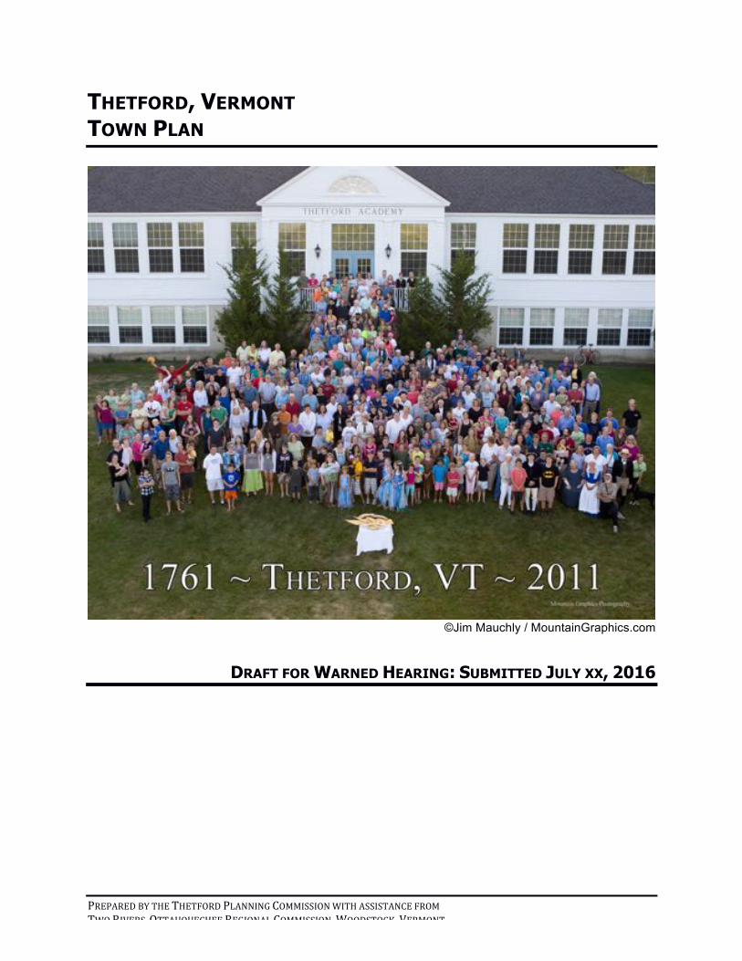
PREPARED BY THE THETFORD PLANNING COMMISSION WITH ASSISTANCE FROM TWO RIVERS6OTTAUQUECHEE REGIONAL COMMISSION,WOODSTOCK,VERMONT THETFORD, VERMONT TOWN PLAN ©Jim Mauchly / MountainGraphics.com DRAFT FOR WARNED HEARING: SUBMITTED JULY XX, 2016
Transcript of VERMONT TOWN PLAN -...
!
PREPARED!BY!THE!THETFORD!PLANNING!COMMISSION!WITH!ASSISTANCE!FROM!!TWO!RIVERS6OTTAUQUECHEE!REGIONAL!COMMISSION,!WOODSTOCK,!VERMONT!
THETFORD, VERMONT TOWN PLAN
!©Jim Mauchly / MountainGraphics.com
DRAFT FOR WARNED HEARING: SUBMITTED JULY XX, 2016
!!
1!
CONTENTS
INTRODUCTION)....................................................................................................................................................)1!PURPOSE!.....................................................................................................................................................................................!1!SUMMARY!OF!CHAPTERS!..........................................................................................................................................................!1!
CHAPTER)I:)HOUSING)..........................................................................................................................................)9!HOUSING!PROFILE!.....................................................................................................................................................................!9!AFFORDABLE!HOUSING!.........................................................................................................................................................!11!RENTAL!HOUSING!..................................................................................................................................................................!14!ELDER!HOUSING!.....................................................................................................................................................................!14!GOALS,!POLICIES,!AND!RECOMMENDATIONS!....................................................................................................................!17!
CHAPTER)II:)EDUCATION)................................................................................................................................)19!EARLY!CHILDHOOD!................................................................................................................................................................!20!CHILDREN!IN!K612!................................................................................................................................................................!21!Governance)...........................................................................................................................................................................)22!Thetford)Academy).............................................................................................................................................................)23!Open)Fields)School).............................................................................................................................................................)25!Home)Schooling)..................................................................................................................................................................)25!Continuing)Education)......................................................................................................................................................)25!
CHALLENGES!...........................................................................................................................................................................!26!GOALS,!POLICIES,!AND!RECOMMENDATIONS!....................................................................................................................!26!
CHAPTER)III:)FUTURE)ECONOMIC)DEVELOPMENT)................................................................................)28!GOALS,!POLICIES!AND!RECOMMENDATIONS!.....................................................................................................................!30!
CHAPTER)IV:)FACILITIES,)SERVICES,)AND)UTILITIES)............................................................................)32!TOWN!AND!COMMUNITY!FACILITIES!..................................................................................................................................!32!1.)Town)Hall)..........................................................................................................................................................................)32!2.)Town)Garage)...................................................................................................................................................................)33!3.)Recycling)Center)............................................................................................................................................................)34!4.)Libraries)............................................................................................................................................................................)35!
Peabody!Library!................................................................................................................................................................................................!35!Bicentennial!Building!......................................................................................................................................................................................!36!The!North!Thetford!Library!..........................................................................................................................................................................!36!
5.)Cemeteries)........................................................................................................................................................................)36!6.)Churches)............................................................................................................................................................................)38!7.)Public)Gathering)Places)..............................................................................................................................................)39!
TOWN!AND!COMMUNITY!SERVICES!....................................................................................................................................!39!1.)Water)Supplies)...............................................................................................................................................................)40!
Thetford!Hill!........................................................................................................................................................................................................!40!North!Thetford!...................................................................................................................................................................................................!40!East!Thetford!.......................................................................................................................................................................................................!40!Post!Mills!...............................................................................................................................................................................................................!41!
2.)Sanitary)Sewer)...............................................................................................................................................................)41!3.)Septage)..............................................................................................................................................................................)41!4.)Solid)Waste).......................................................................................................................................................................)43!5.)Police)Protection)............................................................................................................................................................)43!6.)Fire)and)Emergency)Protection)..............................................................................................................................)44!7.)Emergency)Medical)Services)....................................................................................................................................)45!
Thetford!FAST!Squad!.......................................................................................................................................................................................!45!Upper!Valley!Ambulance!................................................................................................................................................................................!46!
!!
2!
8.)Emergency)Planning)in)Thetford)...........................................................................................................................)46!9.)Health)Care)Facilities)..................................................................................................................................................)46!11.)Recreation)......................................................................................................................................................................)47!
TOWN!AND!COMMUNITY!UTILITIES!....................................................................................................................................!50!GOALS,!POLICIES,!AND!RECOMMENDATIONS!....................................................................................................................!51!Town)and)Community)Facilities)..................................................................................................................................)51!
Libraries!................................................................................................................................................................................................................!52!Cemeteries!...........................................................................................................................................................................................................!52!
Town)and)Community)Services)and)Utilities)..........................................................................................................)53!Water!......................................................................................................................................................................................................................!53!Solid!Waste!and!Septage!................................................................................................................................................................................!53!Police!Protection!...............................................................................................................................................................................................!53!Fire!and!Emergency!Services!.......................................................................................................................................................................!54!Recreation!............................................................................................................................................................................................................!54!Telecommunications!.......................................................................................................................................................................................!55!
CHAPTER)V:)NATURAL)RESOURCES)............................................................................................................)56!WATER!.....................................................................................................................................................................................!57!Flowing)Waters)...................................................................................................................................................................)58!
The!Connecticut!River!.....................................................................................................................................................................................!58!The!Ompompanoosuc!River!and!Tributaries!........................................................................................................................................!59!
Still)Waters)...........................................................................................................................................................................)60!Lakes!and!Ponds!................................................................................................................................................................................................!60!Wetlands!...............................................................................................................................................................................................................!62!Vernal!Pools!.........................................................................................................................................................................................................!63!Groundwater!and!Aquifers!...........................................................................................................................................................................!65!
EARTH!......................................................................................................................................................................................!65!Slope).........................................................................................................................................................................................)65!Agricultural)and)Silvicultural)Soils)............................................................................................................................)66!Landscape)Features)..........................................................................................................................................................)68!
FLORA!&!FAUNA!.....................................................................................................................................................................!68!Forests).....................................................................................................................................................................................)68!Wildlife)....................................................................................................................................................................................)69!
Wildlife!Corridors!.............................................................................................................................................................................................!72!Endangered!and!Threatened!Species!.......................................................................................................................................................!72!
CONCLUSION!............................................................................................................................................................................!73!GOALS,!POLICIES!AND!RECOMMENDATIONS!.....................................................................................................................!73!All)Natural)Resources).......................................................................................................................................................)73!Water).......................................................................................................................................................................................)74!
All!waters!..............................................................................................................................................................................................................!74!Flowing!Waters—Rivers,!Streams!and!Brooks!....................................................................................................................................!75!Still!waters!...........................................................................................................................................................................................................!77!
Lakes!and!ponds!..........................................................................................................................................................................................!77!Wetlands!.........................................................................................................................................................................................................!78!Vernal!pools!..................................................................................................................................................................................................!78!
Groundwater!&!Aquifers!................................................................................................................................................................................!78!Earth)........................................................................................................................................................................................)80!
Agricultural!land!................................................................................................................................................................................................!80!Minerals!.................................................................................................................................................................................................................!81!Landscape!features!...........................................................................................................................................................................................!82!
Flora)&)Fauna)......................................................................................................................................................................)82!General!...................................................................................................................................................................................................................!82!Forests!...................................................................................................................................................................................................................!83!Wildlife!...................................................................................................................................................................................................................!83!Vegetation!............................................................................................................................................................................................................!84!
Atmosphere)...........................................................................................................................................................................)85!
!!
3!
Air!.............................................................................................................................................................................................................................!85!Quiet,!Natural!Light!&!Darkness!.................................................................................................................................................................!85!
CHAPTER)VI:)FLOOD)RESILIENCE)................................................................................................................)86!BACKGROUND!..........................................................................................................................................................................!86!Types)of)Flooding)...............................................................................................................................................................)86!Flood)Plains)..........................................................................................................................................................................)86!Causes)of)Flooding).............................................................................................................................................................)87!National)Flood)Insurance)Program)(NFIP))............................................................................................................)88!Historic)Flood)Events)........................................................................................................................................................)88!
FLOOD!HAZARD!AND!RIVER!CORRIDOR!AREAS!................................................................................................................!89!Flood)Hazard)Regulations)..............................................................................................................................................)89!
PROMOTING!FLOOD!RESILIENCE:!FLOOD!HAZARD!REGULATION!AND!NON!REGULATORY!APPROACHES!............!90!GOALS,!POLICIES!AND!RECOMMENDATIONS!.....................................................................................................................!90!
CHAPTER)VII:)ENERGY).....................................................................................................................................)92!ENERGY!CURRENT!DEMANDS!..............................................................................................................................................!93!CURRENT!ENERGY!SOURCES!................................................................................................................................................!94!NonWrenewable)Sources)...................................................................................................................................................)94!
Fossil!Fuels!...........................................................................................................................................................................................................!94!Nuclear!...................................................................................................................................................................................................................!94!
Renewable)Sources)............................................................................................................................................................)94!Solar!Energy!........................................................................................................................................................................................................!94!Wind!Energy!........................................................................................................................................................................................................!96!Biomass!&!Biogas!Energy!..............................................................................................................................................................................!96!Hydropower!........................................................................................................................................................................................................!98!
Permitting)Considerations).............................................................................................................................................)99!DECREASING!ENERGY!NEED!.................................................................................................................................................!99!Changing)Behavior)............................................................................................................................................................)99!Implementing)Energy)Efficiency).................................................................................................................................)99!
MUNICIPAL!ROLE!IN!ENERGY!EFFICIENCY!......................................................................................................................!100!Thetford)Energy)Committee)........................................................................................................................................)100!Auditing)Municipally)Owned)Buildings)..................................................................................................................)101!PropertyWAssessed)Clean)Energy)(PACE))...............................................................................................................)101!Policy).....................................................................................................................................................................................)101!
Land!Use!..............................................................................................................................................................................................................!101!Transportation!.................................................................................................................................................................................................!102!Energy!Assurance!Planning!........................................................................................................................................................................!102!
GOALS,!POLICIES!AND!RECOMMENDATIONS!...................................................................................................................!103!
CHAPTER)VIII:)TRANSPORTATION)............................................................................................................)106!PRESENT!CONDITIONS!.........................................................................................................................................................!106!Public)Roads).......................................................................................................................................................................)106!Revenue)................................................................................................................................................................................)107!Road)Maintenance)...........................................................................................................................................................)107!Safety).....................................................................................................................................................................................)108!Congestion)...........................................................................................................................................................................)108!Scenic)Roads).......................................................................................................................................................................)109!
TRANSPORTATION!IN!THE!FUTURE!...................................................................................................................................!109!GOALS,!POLICIES!AND!RECOMMENDATIONS!...................................................................................................................!111!
CHAPTER)XI:)HISTORIC)RESOURCES).........................................................................................................)113!THETFORD’S!HISTORIC!STRUCTURES!AND!SITES!...........................................................................................................!113!THETFORD’S!HISTORIC!ARTIFACTS!..................................................................................................................................!115!
!!
4!
TOOLS!FOR!HISTORICAL!PRESERVATION!.........................................................................................................................!116!Private)Citizens)and)Organizations).........................................................................................................................)116!Historic)Resources)Survey)............................................................................................................................................)116!National)Register)of)Historic)Places)........................................................................................................................)117!Local)Historic)Districts,)Design)Control)Districts,)&)Transferable)Development)Rights)...................)118!Revolving)Funds)................................................................................................................................................................)119!Easements)............................................................................................................................................................................)120!Covenants)............................................................................................................................................................................)121!State)Grants)........................................................................................................................................................................)121!Potential)Archeological)Areas)....................................................................................................................................)121!
GOALS,!POLICIES,!AND!RECOMMENDATIONS!..................................................................................................................!122!
CHAPTER)X:)SCENIC)RESOURCES)...............................................................................................................)124!EXISTING!CONDITIONS!........................................................................................................................................................!125!THE!FUTURE!..........................................................................................................................................................................!125!Design)Considerations)....................................................................................................................................................)125!Scenic)Road)Designations).............................................................................................................................................)125!Ridgeline)Development)Controls)...............................................................................................................................)126!Minimization)of)Outdoor)Light)Pollution)..............................................................................................................)126!Competing)Aesthetic,)Safety)and)Expedience)Issues).........................................................................................)127!Aesthetics)of)Business)Districts)..................................................................................................................................)128!
GOALS,!POLICIES!AND!RECOMMENDATIONS!...................................................................................................................!128!
CHAPTER)XI:)LAND)USE).................................................................................................................................)131!EXISTING!CONDITIONS!........................................................................................................................................................!132!EXISTING!LOCAL!LAND!USE!TOOLS!..................................................................................................................................!136!Subdivision)Regulations)................................................................................................................................................)136!Zoning)Bylaw).....................................................................................................................................................................)137!
Village!Residential!Land!Use!Area!(VR)!.................................................................................................................................................!137!Community!Business!Land!Use!Area!(CB)!............................................................................................................................................!138!Neighborhood!Residential!Land!Use!Area!(NR)!................................................................................................................................!138!Rural!Residential!Land!Use!Area!(RR)!...................................................................................................................................................!139!Thetford!Hill!Historic!Preservation!Overlay!District!.......................................................................................................................!139!
Flood)Hazard)Area)Zoning)Bylaw).............................................................................................................................)139!THE!FUTURE!..........................................................................................................................................................................!140!Land)Capability).................................................................................................................................................................)140!Natural)Resource)and)Open)Space)Protection)....................................................................................................)141!Residential)Development)..............................................................................................................................................)141!Zoning)Districts).................................................................................................................................................................)142!Energy)...................................................................................................................................................................................)142!
GOALS,!POLICIES!AND!RECOMMENDATIONS!...................................................................................................................!142!
CHAPTER)XII:)RELATIONSHIP)OF)THIS)PLAN)TO)THE)REGION)........................................................)144!
CHAPTER)XIII:)IMPLEMENTATION)OF)THE)PLAN).................................................................................)146!REGULATORY!APPROACHES!TO!IMPLEMENTATION!.......................................................................................................!146!ACT!250!.................................................................................................................................................................................!146!NON6REGULATORY!APPROACHES!TO!IMPLEMENTATION!.............................................................................................!147!CONTINUING!THE!PLANNING!PROCESS!............................................................................................................................!147!
INTRODUCTION!!
5!
FIGURES
Figure 1: Total Housing Units, 1940–2010 ..................................................................................................... 9!Figure 2: Thetford Housing Stock, 2010 ....................................................................................................... 10!Figure 3: Thetford Housing Occupancy, 2010 .............................................................................................. 10!Figure 4: Price of Residential Houses in Thetford and Surrounding Area, 2000 and 2010 ......................... 11!Figure 5: Thetford Affordable Housing Market Analysis ............................................................................... 14!Figure 6: Vermont Area Nursing and Residential Care Facilities, 2011 ........................................................ 15!Figure 7: Child Care Facilities Thetford and Surrounding Towns, 2015 ....................................................... 21!Figure 8: Thetford Elementary School Enrollment ...................................................................................... 23!Figure 9: Thetford Labor Force Statistics ...................................................................................................... 28!Figure 10: Thetford Business Establishments ............................................................................................... 29!Figure 11: Town-Owned Equipment Housed at the Town Garage ............................................................... 34!Figure 12: Cemeteries in Thetford ................................................................................................................. 37!Figure 13: Thetford’s Major Fire-Fighting Equipment ................................................................................. 44!Figure 14: Thetford Agricultural Area and Soils ........................................................................................... 67!Figure 15: Effect of Habitat Fragmentation on Number of Wildlife Species ................................................ 70!Figure 16: Vermont Energy Use by Sector, 2013 ........................................................................................... 93!Figure 17: Thetford Road Mileage by Functional Classification ................................................................. 106!Figure 18: Highway Revenue ........................................................................................................................ 107!Figure 19: Population of Thetford and Area Towns, 1910–2010 ................................................................. 132!Figure 20: Population Growth Rate per Decade for Orange County, Thetford, and Area Towns .............. 133!Figure 21: Thetford Taxable Property by Type ............................................................................................. 134!Figure 22: Approved Subdivisions, 1994–2012 ........................................................................................... 135!Figure 23: Zoning Permits Issued, 1994–2012 ............................................................................................ 136!
PHOTO CREDITS
Cover: Thetford 250th Celebration, ©Jim Mauchly / MountainGraphics.com Photo 1: Union Village School, c. 1930 – Thetford Historical Society ........................................................... 19!Photo 2: Thetford Academy Mountain Day Hike, 2015 – Dan Grossman ................................................... 24!Photo 3: Town Hall in Thetford Center ......................................................................................................... 33!Photo 4: Thetford Recycling Center .............................................................................................................. 43!Photo 5: Hockey at Child’s Pond .................................................................................................................... 47!Photo 6: Thetford Center Common ............................................................................................................... 48!Photo 7: North Star –Tom Urgo .................................................................................................................... 56!Photo 8: Rock Outcrop in Thetford Center – Li Shen ................................................................................... 56!Photo 9: Ompompanoosuc Bank Erosion – Li Shen ..................................................................................... 59!Photo 10: Spotted Salamander Eggs on Thetford Hill – Li Shen .................................................................. 63!Photo 11: Logging Operation – Li Shen ......................................................................................................... 67!Photo 12: Barred Owl – John Joline .............................................................................................................. 70!Photo 13: Marsh Mermaid Weed – USACE website ..................................................................................... 72!Photo 14: Renewable Energy Sources – R. Walker ....................................................................................... 92!Photo 15: Thetford Elementary School Photovoltaic Solar Array – Erin Sterner ........................................ 95!Photo 16: Multiple Solar Energy Sources on a Single Dwelling – R. Walker ............................................... 96!Photo 17: Plowing on Thetford Hill, c. 1930 – Thetford Historical Society ................................................. 114!Photo 18: Thetford Hill with Elms, c. 1930 – Thetford Historical Society .................................................. 117!Photo 19: Thetford, The View from Houghton Hill of Lake Abenaki and Beyond – Kevin O’Hara ............ 124!Photo 20: The Milkhouse on Tucker Hill Road, Originally the W.H. Messer Farm, as Seen from the Bill
Hill Trail – Dean Whitlock ............................................................................................................ 128!Photo 21: Thetford Resident Roger Hanlon Enjoys the View Southward Across Thetford from Sawnee
Bean – Tig Tillinghast ................................................................................................................... 130!
INTRODUCTION!!
1!
INTRODUCTION
PURPOSE This is the 2015 Thetford Town Plan, written eight years after the last plan was first approved. The Plan is written for the residents of Thetford, and anyone else interested in the growth and development of the Town. The Plan is intended to provide a ten- thousand foot view of Thetford in 2015, summarizing information about Thetford and identifying goals, policies, recommendations, and enabling language (consistent with Vermont law) so that Thetford’s various departments and review boards can pursue the goals of the Town.
A town plan is intended to maintain some control over the inevitable and constant change that goes on in every town. We cannot stop the exact form that development will take over time. Every five years, as required by state law, we imagine what we would like our town to look like when our grandchildren have grandchildren. We balance the individual’s right to live the way he or she wants with the needs and desires of townspeople as a whole, today and in the foreseeable future.
We live in a beautiful place. Trees and mountains surround us. Streams and lakes water the land. When snow falls in December, our town becomes a perfect place, at least until the first footprints and tire tracks break the spell. This could easily change. It is not an exaggeration to say that Thetford could look like any one of the hundreds of overcrowded, overdeveloped towns up and down the east coast that let development happen to them, especially during the nineteen fifties, sixties, and seventies. There is plenty of money to be made building tract homes, strip malls, and box stores on former farmland. Thetford, a town with not even one stoplight, is only 20 minutes from Route 12A in West Lebanon, where some of us can still remember corn growing. Even in quiet Thetford, we have learned the cost of not educating ourselves about the potential consequences of development from the experience of the operation and cleanup of the Elizabeth Mine.
SUMMARY OF CHAPTERS The Planning Commission, after consulting with the Two Rivers-Ottauquechee Regional Commission and residents who attended Planning Commission meetings and forums, has made many adjustments to the previous Town Plan (2007, readopted 2012). The Planning Commission understands that these changes will bring the Town Plan into
INTRODUCTION!!
2!
compliance with state law and the Regional Plan1, as well as with the expressed desires of the townspeople of Thetford.
I. The Housing chapter addresses the fact that Thetford’s housing market, like that in other Upper Valley communities, has experienced a low growth rate for new single-family homes over the last ten years. The highest demand is for affordable rentals and modest senior housing units, both of which are currently in limited supply in Thetford. This pent-up demand has spurred the Senior & Affordable Housing Committee to consider the feasibility of constructing a Senior/Affordable Housing project in East Thetford.
Town Plan Goals for Housing
1. Encourage and provide the opportunity for safe, adequate, and affordable shelter for present and future populations.
2. Have a density and distribution of housing throughout the town that allow for the continued maintenance of the working landscape.
3. Preserve historic structures in ways appropriate to serve the need for housing.
4. Have a mix of housing types throughout town, provided they do not put an undue burden on town services and facilities.
5. Incorporate energy conservation measures in upgrades and rehabilitation of existing housing stock.
6. Support community activities and initiatives that enable “aging in place” to occur.
7. Accommodate housing that is affordable for a mix of households having moderate, low, and very low incomes.
II. The Education chapter focuses on the current state of public and private education for our children, from infancy through high school, and also references the opportunities available for continuing formal education for people who live in Thetford, even though post-high-school opportunities are, for the most part, concentrated 20 miles south of Thetford.
Town Plan Goals for Education
1. Support competitively priced child care services and facilities that meet the needs of residents.
1 See Two Rivers-Ottauquechee Regional Commission, http://www.trorc.org/
INTRODUCTION!!
3!
2. Continue to provide ever-improving education for all young people, in facilities that meet or exceed the state minimum standards.
3. Improve access for residents to all forms of adult education, including those that enable career change and lifelong learning.
III. The Future Economic Development chapter encourages sustainable economic growth in harmony with Thetford’s rural character and traditional pattern of development. The chapter describes our current economic assets and recommends that the Town consider enrolling in Vermont’s Village Center Designation Program with the Vermont Agency of Commerce and Economic Development. Important benefits of this program include priority consideration for state grants and tax credits for commercial businesses to redevelop historic buildings. Ultimately, achieving the strong and long lasting economic growth the Town desires requires both effective planning and sensible land use regulations that guide future economic development and improve the community.
Town Plan Goals for Future Economic Development
1. Strengthen the identity and vitality of Thetford’s villages.
2. Encourage a strong and diverse local economy that provides satisfying and rewarding employment opportunities for residents while maintaining the community’s rural character.
3. Encourage businesses that do not endanger natural resources and integrate them into villages.
4. Encourage land use that helps create sustainable local jobs that pay a living wage, enabling workers to live in Thetford.
5. Encourage an inter-generational population, with housing, education, activities, and employment opportunities for a wide range of ages.
IV. In the Facilities, Services, and Utilities chapter, one can find new information on continuing improvements to the “building envelopes” of our Town-owned facilities, resulting in reduced energy use; the ongoing need to have a vibrant recreation program and associated facilities to support a physically healthy community; and the expressed goal of many residents for high-speed Internet access. A statement has been added regarding existing and proposed buildings and facilities, including power generating plants and transmission lines, storm drainage, and other facilities and activities, with recommendations on how to meet future needs for community facilities and services, with suggested priorities of need, costs, and method of financing.
INTRODUCTION!!
4!
Town Plan Goals for Facilities, Services, and Utilities
1. Maintain Town-owned facilities and upgrade energy performance, where practical, to maintain property values and reduce operating expenses.
2. Continue to support the Library Federation and the individual libraries and foster cooperation between the libraries in town, while preventing unnecessary duplication of services and encouraging efficient use of town resources.
3. Increase access to technology and digital literacy for library patrons, staff, and volunteers.
4. Ensure adequate space for future burials.
5. Continue to protect and preserve the quality and quantity of water resources in the town.
6. Continue to support efforts to recycle and programs that encourage reuse and recycling.
7. Maintain enough of a police presence to result in an acceptable level of public safety.
8. Maintain a well-trained and well-equipped volunteer fire department and emergency services department.
9. Ensure fire safety in homes and businesses.
10. Support recreation opportunities for all ages in Thetford.
11. Support public and private efforts to bring high-speed Internet services to all areas of Thetford.
V. The Natural Resources chapter has been extensively rewritten. Along with input from the community at large, we received a great deal of help from the Thetford Conservation Commission, to include current research and specific suggestions for options that seem to hold the most promise for effective protection and use of our natural resources.
Town Plan Goals for Natural Resources
1. Conserve and improve Thetford’s natural resources so they are healthier in one hundred years than they are today.
2. Protect and improve the quality of Thetford’s water resources and their natural environments.
3. Ensure that groundwater quality throughout Thetford is pure enough for private and public water supply.
INTRODUCTION!!
5!
4. Preserve land with agricultural potential for agricultural activity.
5. Use gravel, sand, and other mineral resources responsibly to provide long-term benefit to the town.
6. Conserve and develop living natural resources of diverse wildlife and vegetation, supporting human interaction with the natural world through observing, hunting, fishing, forestry, farming, gardening, and other sustainable activities.2
7. Insulate rare, threatened, and endangered plants and animals as identified by the Vermont Natural Heritage Information Project from disruptive land use.3
8. Ensure that animals and plants are able to disperse freely and over long distances between forested blocks.
9. Protect the natural environment and ensure the continued health of important habitats such as wetlands, forests, grasslands, shrublands, unusual land features, and natural communities.
10. Maintain the high quality of the town’s air.
VI. The Flood Resilience chapter acknowledges that flooding from both flash floods and inundation can create significant hardships for both the private citizens of Thetford as well as for our town at large. As a community, we are wise to maintain our wetlands and buffer zones as well as our town infrastructure in an effort to better cope with severe weather events including winter/spring flooding caused by ice jams. Proper planning and diligent infrastructure maintenance will help minimize damage and the associated expenses and will help Thetford recover more quickly from the impacts caused by flooding.
Town Plan Goals for Flood Resilience
1. Maintain and enhance use of flood hazard areas as open space, greenways, non-commercial recreation and/or agricultural land.
2. Ensure no net loss of flood storage capacity in an effort to minimize potential negative impacts. These impacts include the loss of life and property, disruption of commerce, and demand for extraordinary public services and expenditures that result from flood damage.
3. Protect town infrastructure and buildings from the potential of flood damage.
2 http://www.vtfishandwildlife.com/library/maps/Community_Wildlife_Program/complete.pdf 3 http://www.vtfishandwildlife.com/wildlife_nongame.cfm
INTRODUCTION!!
6!
VII. Our use of and access to the energy we all depend upon for transportation, heat, communications, and the convenience of modern appliances continues to be a critical issue. The Energy chapter discusses how our Thetford Energy Committee has given us opportunities to save energy through its home weatherization project and, more recently, through two community-based solar electricity projects.
Town Plan Goal for Energy
Foster a sustainable energy future that minimizes environmental impact, supports our local economy, emphasizes energy conservation and efficiency, and increases use of local and regional renewable energy sources.
VIII. The Transportation chapter focuses on the changes in commuting habits for the majority of residents working outside of town. Commutes have gotten longer, on average, and 75% of Thetford residents drive alone to work. This pattern is unsustainable over the long run, and the plan identifies alternatives to the one car, one driver model so common at this time.
Town Plan Goals for Transportation
1. Maintain a safe and durable road system.
2. Prevent congestion on town roads.
3. Increase the use of public transit and ridesharing.
4. Improve pedestrian access in Thetford’s villages.
XI. The Historic Resources chapter describes the state of the historic structures, sites, artifacts, and recorded history of Thetford. It lists some of the most significant structures that have been preserved and maintained by owners and the Town, and describes the activities of the Thetford Historical Society and its many historical assets. It also contains a list of tools for historical preservation, such as state and federal programs that provide financial or expert support to preservation efforts.
Town Plan Goal for Historic Resources
Protect existing historic structures and the environment in which they are situated, while balancing preservation with energy efficiency and providing for the needs of residents.
INTRODUCTION!!
7!
X. The Scenic Resources chapter describes the importance of Thetford’s views, byways, and other scenic resources to the environment, economy, and quality of life in the town and makes recommendations for preserving our aesthetic heritage so that the things we most admire about the way our town looks today will still be recognizable to future generations.
Town Plan Goals for Scenic Resources
1. Protect our aesthetic heritage so that the things we most admire about the way our town looks today will still be recognizable to future generations.
2. Preserve scenic resources.
XI. The Land Use chapter, more than any other, directly affects Thetford’s Zoning Bylaw. The Planning Commission revised the text to reflect the ongoing expression of support in town for the rich and varied natural heritage and the rural and village character of Thetford, while also encouraging a vibrant, sustainable local economy. The chapter includes a recommendation for a new zoning district in Post Mills designed to focus commercial development in the village center and discourage sprawl outward from the village.
Town Plan Goals for Land Use
1. Conserve Thetford’s natural heritage. (See the Natural Resources chapter.)
2. Preserve the rural character of Thetford and strengthen the identity of Thetford’s villages.
3. Promote a small town quality and character in housing development to preserve and enliven Thetford’s villages.
4. Encourage businesses that do not endanger natural resources and integrate them into villages. (See Goal #2.)
5. Encourage land use that helps create a sustainable local economy and jobs that pay a living wage, enabling workers to live in Thetford.
6. Encourage an inter-generational population, with housing, education, activities, and employment opportunities for a wide range of ages.
INTRODUCTION!!
8!
A copy of this Town Plan can be found on the Thetford website, under the Documents tab (www.thetfordvermont.us/town-documents). Scroll down to find the Thetford 2016 Plan. 4
A town plan is a guide to the future. We look forward to improvements in housing, transportation, communication, land use, education, agriculture, business, emergency response, energy use and production, waste management, public safety, and recreation. Thinking about these things now can improve the quality of life for all Thetford residents in a future we can only imagine.
It is impossible to please everyone with such a broad ranging document. There are quite a few places where the information presented will have changed by the time you read the final version. If you find too many faults in the Thetford Town Plan, why not consider helping write the next one? There are often open spots on the Planning Commission. The plan and regulation upgrade is a five-year cycle. Even if you are not ready to serve, you are welcome to attend our meetings, held at the Town Hall on the first and third Tuesdays of the month at 7:15 p.m. Approval of this plan will be followed, as per state law, by a re-writing of Town zoning and subdivision regulations to bring them into compliance with the new plan.
This plan builds on the work of previous Planning Commissions and all participants who have discussed the town's future; we thank the many people whose contributions have made this a better plan, and especially immediate past Planning Commissioners Liora Alschuler, Patrick Kearney, and Terry Longo.
Respectfully submitted by the Thetford Planning Commission:
Jason Crance, Liz Ryan Cole, Patricia Norton, Michael Schunk, Jamie Thaxton, Dean Whitlock (Recording Clerk), Kevin O’Hara (Chair)
4 The last Thetford Town Plan (re-adopted in 2012) is posted at http://www.thetfordvermont.us/town-documents/ (See “Thetford 2012 Plan”.)
CHAPTER!I:!HOUSING!!
9!
CHAPTER I: HOUSING Many towns in New England experienced rapid economic growth and residential sprawl in the last forty years of the 20th century. Quite often, their present appearance bears little resemblance to the pre-World War II historical development. Thetford, however, has not experienced a great deal of dislocated development and still bears a strong resemblance to its past settlement patterns. The last 20 years have shown a slow tapering-off of residential growth, which in turn, has somewhat reduced the potential pressures for such development. A key element to the town’s character is its housing – the quality, availability, and variety of places for its residents to live. Housing has a large influence on the rate and direction of current and future business and commercial growth. Figure 1: Total Housing Units, 1940–2010
Source: US Census A major goal of this chapter is to encourage planning that meets two important community objectives:
1. To encourage, safe, adequate, and affordable shelter for present and future populations
2. To have a density and a distribution of housing throughout the town that allow for the continued maintenance of the working landscape5
Although the provision and maintenance of a town’s housing stock is primarily a private sector activity, the growth and development of housing affects the environment within which the town is located as well as the facilities and services the town provides or will provide. Housing constructed in the absence of adequate planning for public facilities can overburden schools, roads, and other municipal services. Poorly located housing can also overburden the soils important to safe sewage disposal, pollute water supplies, destroy important wildlife habitat, and be washed away in floods. Housing that is inadequate to meet the demand of one town can strain adjacent towns and prevent people from living close to their jobs.
HOUSING PROFILE According to the US Census, there were 1238 housing units in Thetford in 2010, up from the 2000 total of 1164 housing units (see Figure 1). This amounted to an increase of 74
5 Vermont Working Landscape Partnership Council, Vermont Council on Rural Development, 2012.
295$ 330$ 374$
523$
805$
1059$
1164$
1238$
0$
100$
200$
300$
400$
500$
600$
700$
800$
900$
1000$
1100$
1200$
1300$
1940$ 1950$ 1960$ 1970$ 1980$ 1990$ 2000$ 2010$
Num
ber$of$Hou
sing$Units$
Year$
Total$Housing$Units$1940?2010$
CHAPTER!I:!HOUSING!!
10!
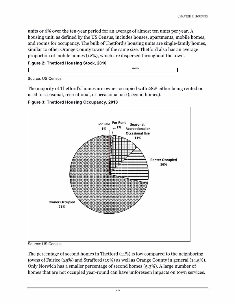
units or 6% over the ten-year period for an average of almost ten units per year. A housing unit, as defined by the US Census, includes houses, apartments, mobile homes, and rooms for occupancy. The bulk of Thetford’s housing units are single-family homes, similar to other Orange County towns of the same size. Thetford also has an average proportion of mobile homes (12%), which are dispersed throughout the town. Figure 2: Thetford Housing Stock, 2010
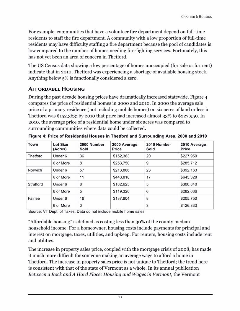
Source: US Census The majority of Thetford’s homes are owner-occupied with 28% either being rented or used for seasonal, recreational, or occasional use (second homes). Figure 3: Thetford Housing Occupancy, 2010
!Source: US Census The percentage of second homes in Thetford (11%) is low compared to the neighboring towns of Fairlee (25%) and Strafford (19%) as well as Orange County in general (14.5%). Only Norwich has a smaller percentage of second homes (5.3%). A large number of homes that are not occupied year-round can have unforeseen impacts on town services.
For$Sale$1%$
For$Rent$1%$
Seasonal,$Recrea1onal$or$Occasional$Use$
11%$
Renter$Occupied$16%$
Owner$Occupied$71%$
CHAPTER!I:!HOUSING!!
11!
For example, communities that have a volunteer fire department depend on full-time residents to staff the fire department. A community with a low proportion of full-time residents may have difficulty staffing a fire department because the pool of candidates is low compared to the number of homes needing fire-fighting services. Fortunately, this has not yet been an area of concern in Thetford.
The US Census data showing a low percentage of homes unoccupied (for sale or for rent) indicate that in 2010, Thetford was experiencing a shortage of available housing stock. Anything below 5% is functionally considered a zero.
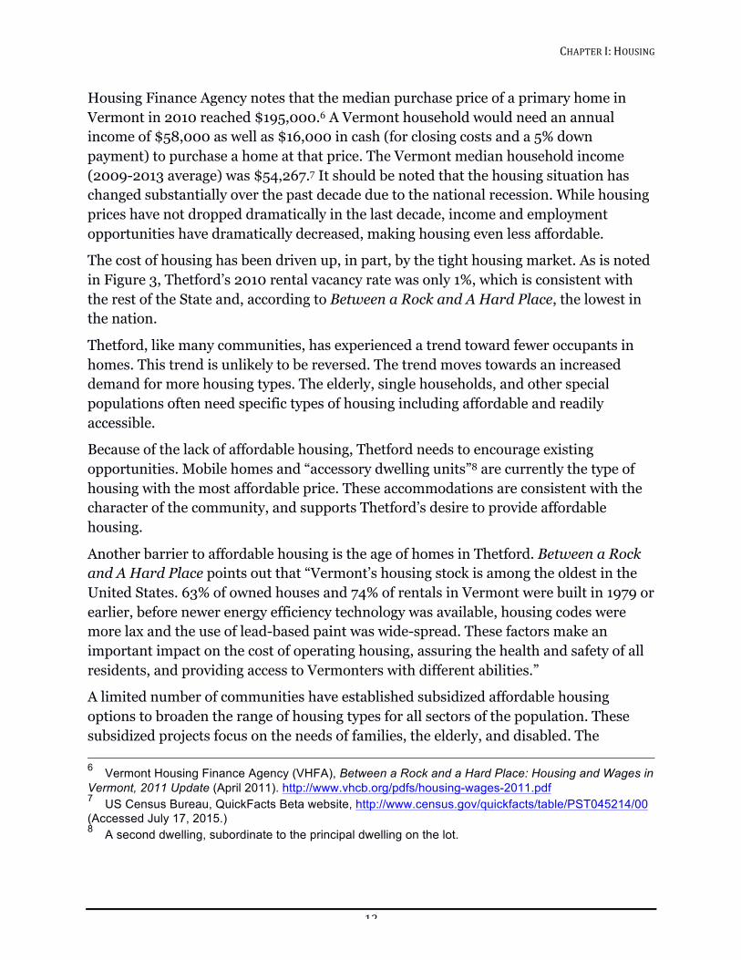
AFFORDABLE HOUSING During the past decade housing prices have dramatically increased statewide. Figure 4 compares the price of residential homes in 2000 and 2010. In 2000 the average sale price of a primary residence (not including mobile homes) on six acres of land or less in Thetford was $152,363; by 2010 that price had increased almost 33% to $227,950. In 2010, the average price of a residential home under six acres was compared to surrounding communities where data could be collected. Figure 4: Price of Residential Houses in Thetford and Surrounding Area, 2000 and 2010
Town Lot Size (Acres)
2000 Number Sold
2000 Average Price
2010 Number Sold
2010 Average Price
Thetford Under 6 36 $152,363 20 $227,950
6 or More 8 $253,750 9 $285,712
Norwich Under 6 57 $213,886 23 $392,163
6 or More 11 $443,818 17 $645,328
Strafford Under 6 8 $182,625 5 $300,840
6 or More 5 $119,320 6 $282,086
Fairlee Under 6 16 $137,804 8 $205,750
6 or More 0 3 $126,333 Source: VT Dept. of Taxes. Data do not include mobile home sales. “Affordable housing” is defined as costing less than 30% of the county median household income. For a homeowner, housing costs include payments for principal and interest on mortgage, taxes, utilities, and upkeep. For renters, housing costs include rent and utilities.
The increase in property sales price, coupled with the mortgage crisis of 2008, has made it much more difficult for someone making an average wage to afford a home in Thetford. The increase in property sales price is not unique to Thetford; the trend here is consistent with that of the state of Vermont as a whole. In its annual publication Between a Rock and A Hard Place: Housing and Wages in Vermont, the Vermont
CHAPTER!I:!HOUSING!!
12!
Housing Finance Agency notes that the median purchase price of a primary home in Vermont in 2010 reached $195,000.6 A Vermont household would need an annual income of $58,000 as well as $16,000 in cash (for closing costs and a 5% down payment) to purchase a home at that price. The Vermont median household income (2009-2013 average) was $54,267.7 It should be noted that the housing situation has changed substantially over the past decade due to the national recession. While housing prices have not dropped dramatically in the last decade, income and employment opportunities have dramatically decreased, making housing even less affordable.
The cost of housing has been driven up, in part, by the tight housing market. As is noted in Figure 3, Thetford’s 2010 rental vacancy rate was only 1%, which is consistent with the rest of the State and, according to Between a Rock and A Hard Place, the lowest in the nation.
Thetford, like many communities, has experienced a trend toward fewer occupants in homes. This trend is unlikely to be reversed. The trend moves towards an increased demand for more housing types. The elderly, single households, and other special populations often need specific types of housing including affordable and readily accessible.
Because of the lack of affordable housing, Thetford needs to encourage existing opportunities. Mobile homes and “accessory dwelling units”8 are currently the type of housing with the most affordable price. These accommodations are consistent with the character of the community, and supports Thetford’s desire to provide affordable housing.
Another barrier to affordable housing is the age of homes in Thetford. Between a Rock and A Hard Place points out that “Vermont’s housing stock is among the oldest in the United States. 63% of owned houses and 74% of rentals in Vermont were built in 1979 or earlier, before newer energy efficiency technology was available, housing codes were more lax and the use of lead-based paint was wide-spread. These factors make an important impact on the cost of operating housing, assuring the health and safety of all residents, and providing access to Vermonters with different abilities.”
A limited number of communities have established subsidized affordable housing options to broaden the range of housing types for all sectors of the population. These subsidized projects focus on the needs of families, the elderly, and disabled. The 6 Vermont Housing Finance Agency (VHFA), Between a Rock and a Hard Place: Housing and Wages in Vermont, 2011 Update (April 2011). http://www.vhcb.org/pdfs/housing-wages-2011.pdf 7 US Census Bureau, QuickFacts Beta website, http://www.census.gov/quickfacts/table/PST045214/00 (Accessed July 17, 2015.) 8 A second dwelling, subordinate to the principal dwelling on the lot.

CHAPTER!I:!HOUSING!!
13!
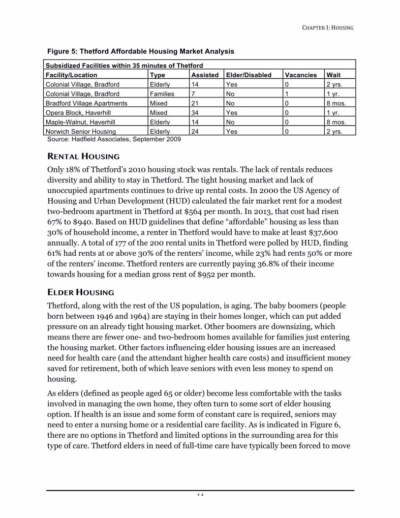
demand and availability for this type of housing is high, as indicated by vacancies and wait times noted in Figure 5.
CHAPTER!I:!HOUSING!!
14!
Figure 5: Thetford Affordable Housing Market Analysis
Subsidized Facilities within 35 minutes of Thetford Facility/Location Type Assisted Elder/Disabled Vacancies Wait Colonial Village, Bradford Elderly 14 Yes 0 2 yrs. Colonial Village, Bradford Families 7 No 1 1 yr. Bradford Village Apartments Mixed 21 No 0 8 mos. Opera Block, Haverhill Mixed 34 Yes 0 1 yr. Maple-Walnut, Haverhill Elderly 14 No 0 8 mos. Norwich Senior Housing Elderly 24 Yes 0 2 yrs. Source: Hadfield Associates, September 2009
RENTAL HOUSING Only 18% of Thetford’s 2010 housing stock was rentals. The lack of rentals reduces diversity and ability to stay in Thetford. The tight housing market and lack of unoccupied apartments continues to drive up rental costs. In 2000 the US Agency of Housing and Urban Development (HUD) calculated the fair market rent for a modest two-bedroom apartment in Thetford at $564 per month. In 2013, that cost had risen 67% to $940. Based on HUD guidelines that define “affordable” housing as less than 30% of household income, a renter in Thetford would have to make at least $37,600 annually. A total of 177 of the 200 rental units in Thetford were polled by HUD, finding 61% had rents at or above 30% of the renters’ income, while 23% had rents 50% or more of the renters’ income. Thetford renters are currently paying 36.8% of their income towards housing for a median gross rent of $952 per month.
ELDER HOUSING Thetford, along with the rest of the US population, is aging. The baby boomers (people born between 1946 and 1964) are staying in their homes longer, which can put added pressure on an already tight housing market. Other boomers are downsizing, which means there are fewer one- and two-bedroom homes available for families just entering the housing market. Other factors influencing elder housing issues are an increased need for health care (and the attendant higher health care costs) and insufficient money saved for retirement, both of which leave seniors with even less money to spend on housing.
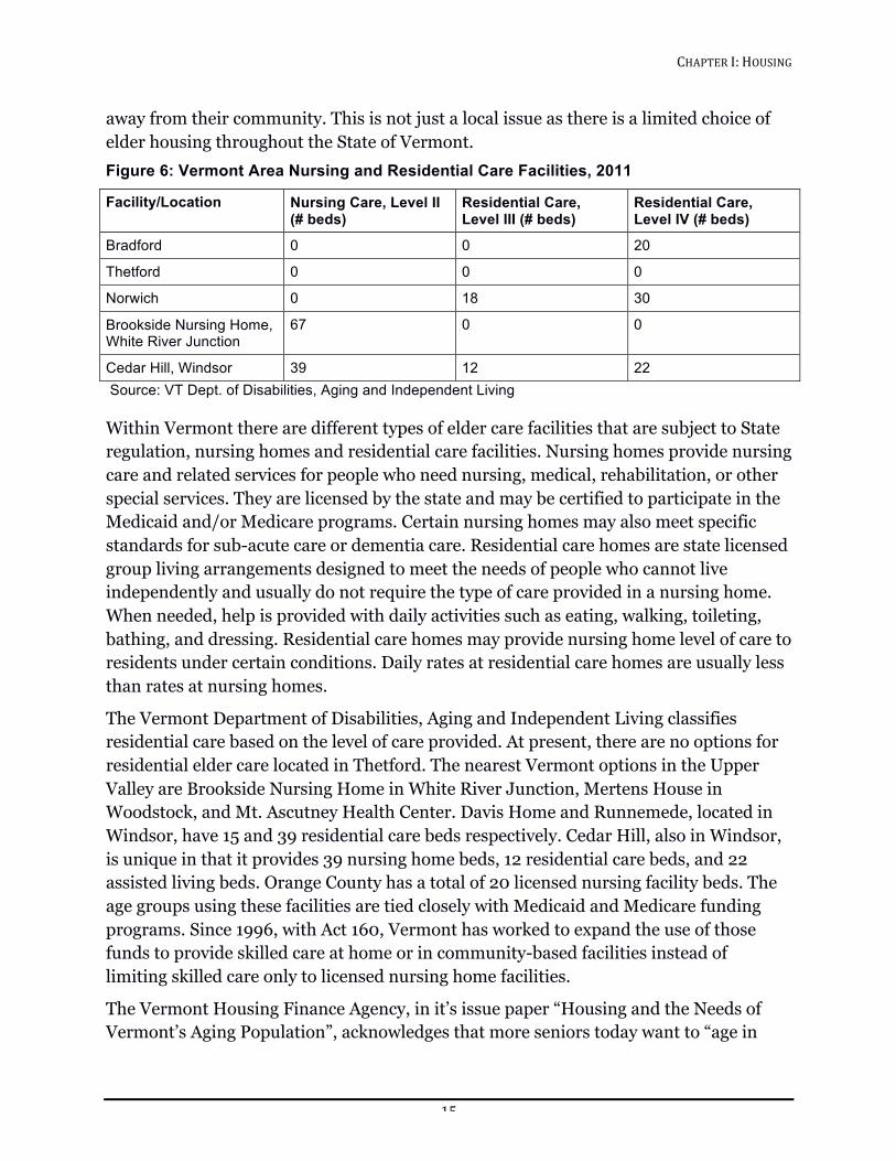
As elders (defined as people aged 65 or older) become less comfortable with the tasks involved in managing the own home, they often turn to some sort of elder housing option. If health is an issue and some form of constant care is required, seniors may need to enter a nursing home or a residential care facility. As is indicated in Figure 6, there are no options in Thetford and limited options in the surrounding area for this type of care. Thetford elders in need of full-time care have typically been forced to move
CHAPTER!I:!HOUSING!!
15!
away from their community. This is not just a local issue as there is a limited choice of elder housing throughout the State of Vermont. Figure 6: Vermont Area Nursing and Residential Care Facilities, 2011
Facility/Location Nursing Care, Level II (# beds)
Residential Care, Level III (# beds)
Residential Care, Level IV (# beds)
Bradford 0 0 20
Thetford 0 0 0
Norwich 0 18 30
Brookside Nursing Home, White River Junction
67 0 0
Cedar Hill, Windsor 39 12 22 Source: VT Dept. of Disabilities, Aging and Independent Living Within Vermont there are different types of elder care facilities that are subject to State regulation, nursing homes and residential care facilities. Nursing homes provide nursing care and related services for people who need nursing, medical, rehabilitation, or other special services. They are licensed by the state and may be certified to participate in the Medicaid and/or Medicare programs. Certain nursing homes may also meet specific standards for sub-acute care or dementia care. Residential care homes are state licensed group living arrangements designed to meet the needs of people who cannot live independently and usually do not require the type of care provided in a nursing home. When needed, help is provided with daily activities such as eating, walking, toileting, bathing, and dressing. Residential care homes may provide nursing home level of care to residents under certain conditions. Daily rates at residential care homes are usually less than rates at nursing homes.
The Vermont Department of Disabilities, Aging and Independent Living classifies residential care based on the level of care provided. At present, there are no options for residential elder care located in Thetford. The nearest Vermont options in the Upper Valley are Brookside Nursing Home in White River Junction, Mertens House in Woodstock, and Mt. Ascutney Health Center. Davis Home and Runnemede, located in Windsor, have 15 and 39 residential care beds respectively. Cedar Hill, also in Windsor, is unique in that it provides 39 nursing home beds, 12 residential care beds, and 22 assisted living beds. Orange County has a total of 20 licensed nursing facility beds. The age groups using these facilities are tied closely with Medicaid and Medicare funding programs. Since 1996, with Act 160, Vermont has worked to expand the use of those funds to provide skilled care at home or in community-based facilities instead of limiting skilled care only to licensed nursing home facilities.
The Vermont Housing Finance Agency, in it’s issue paper “Housing and the Needs of Vermont’s Aging Population”, acknowledges that more seniors today want to “age in
CHAPTER!I:!HOUSING!!
16!
place,” which means choosing to remain at home or in a supportive living community as they grow older without having to move each time their needs increase. Considering the lack of availability of nursing homes in Thetford, and Vermont as a whole, aging in place may be the optimal way to address elder housing in the future. Having the right housing includes the ability to stay active and engaged in the community as a whole. Considering the high cost of housing in Thetford, aging in place may not be an affordable option for many older residents.
Several municipalities have benefited from planned retirement communities that provide for older persons. Innovative land use policies and development practices that accommodate special needs should be encouraged. Such land uses are best located in close proximity to existing village centers where basic services are available. An example of this type of facility is Menig Extended Care, a senior living community on a 30-acre campus in Randolph Center that is part of the Gifford Medical Center. When expansion is completed, the campus will have 100 independent living apartments, 20 assisted living units and end-of-life care facility, all in one place. The scope and infrastructure necessary for a project of this size may not be suitable or appropriate for Thetford, and other options might have to be considered.
To better understand Thetford’s housing issues and options, Thetford’s Senior and Affordable Housing Committee, in conjunction with the Thetford Elder Network and the non-profit Ompompanoosuc Community Trust, has prepared an affordable housing market analysis. The recommendations of this analysis provided the framework to evaluate a community-based combined senior living and affordable housing development for Thetford. Partnering with developer, Twin Pines Housing Trust, the project has identified property in East Thetford where existing businesses can provide resident services within walking distance and allow opportunities for more diverse businesses to develop. While helping the community business area, the project’s planning goals can also serve the greater community by providing space for activities such as community suppers, senior center, or an office for a “community nurse”.
Other towns that currently have a town or parish nurse are Norwich, Lyme, Hanover, and Woodstock. The community nurse model has the support of the “Community Health Team Plan”, part of the Vermont Health Care Reform Blueprint for Health initiative. In some cases, state funding can be provided. The community nurse is an advocate and trusted community neighbor who can coordinate and integrate health and social resources available in the area and helping those in need of assistance. The community nurse can be a critical element in enabling elders to age in place within their own homes. (See the Facilities, Services, and Utilities chapter for further discussion of the community nurse.)
CHAPTER!I:!HOUSING!!
17!
GOALS, POLICIES, AND RECOMMENDATIONS Goals
1. Encourage and provide the opportunity for safe, adequate, and affordable shelter for present and future populations.
2. Have a density and distribution of housing throughout the town that allow for the continued maintenance of the working landscape.
3. Preserve historic structures in ways appropriate to serve the need for housing.
4. Have a mix of housing types throughout town, provided they do not put an undue burden on town services and facilities.
5. Incorporate energy conservation measures in upgrades and rehabilitation of existing housing stock.
6. Support community activities and initiatives that enable “aging in place” to occur.
7. Accommodate housing that is affordable for a mix of households having moderate, low, and very low incomes.
Polices
1. Use Town zoning to ensure a mix of housing types and density in locations supported by the community’s ability to provide adequate public facilities (e.g., schools and municipal services).
2. Keep housing affordable by planning for appropriately sized lots, accessory apartments, and clustered developments consistent with the desire to maintain the town’s rural qualities.
3. Work with businesses and non-profit housing corporations to help Thetford better meet the demands for affordable housing.
4. Enable provisions for accommodating special-needs populations.
5. Review the location of primary and vacation housing, related amenities, and land uses for planning with due regard to the physical limitations of the site and proximity to current or planned public and private services such as roads and commercial/service centers.
6. Encourage the location of future housing to complement existing or planned employment patterns, travel times, and energy demand.
7. Record with the Town evidence of compliance with Vermont Energy Codes for all housing and building construction.
8. Encourage the use of accessory dwellings units.

CHAPTER!I:!HOUSING!!
18!
Recommendations
1. The Planning Commission should review zoning policy to encourage the development of senior and affordable housing in appropriate areas.
2. The Planning Commission should consider additional ways to encourage rental housing options in existing and new homes as part of the on-going review of current zoning guidelines.
3. The Town should support Thetford Elder Network and the Senior and Affordable Housing Committee’s initiative to provide affordable housing to Thetford.
4. The Town should implement a system to educate and inform home owners and contractors about the benefits of energy efficiency and the need for compliance with REBS (Residential Energy Building Standards) and recording certifications with the Town Clerk.
5. The Town should undertake “A Cost of Community Services” (CosCS) study to analyze the financial demands of public services and costs to provide these services as a basis of information to better plan the town’s future growth and policies.
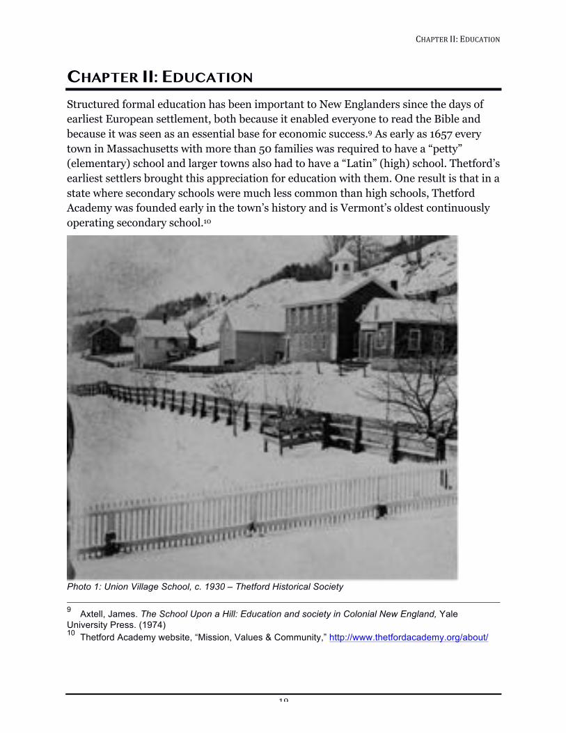
CHAPTER!II:!EDUCATION!!
19!
CHAPTER II: EDUCATION Structured formal education has been important to New Englanders since the days of earliest European settlement, both because it enabled everyone to read the Bible and because it was seen as an essential base for economic success.9 As early as 1657 every town in Massachusetts with more than 50 families was required to have a “petty” (elementary) school and larger towns also had to have a “Latin” (high) school. Thetford’s earliest settlers brought this appreciation for education with them. One result is that in a state where secondary schools were much less common than high schools, Thetford Academy was founded early in the town’s history and is Vermont’s oldest continuously operating secondary school.10
!Photo 1: Union Village School, c. 1930 – Thetford Historical Society 9 Axtell, James. The School Upon a Hill: Education and society in Colonial New England, Yale University Press. (1974) 10 Thetford Academy website, “Mission, Values & Community,” http://www.thetfordacademy.org/about/
CHAPTER!II:!EDUCATION!!
20!
Education today means much more than the reading, writing, and arithmetic important in colonial times. This chapter has been written keeping in mind the fact that education can be both on-site and distance-based and can happen at all ages, beginning with early childhood education and continuing all the way through post-secondary, career-change-focused, and lifelong learning opportunities. Thetford values education at many levels: it helps individuals achieve economic success; it fosters thoughtful and engaged citizens; and it provides a foundation for rich, rewarding lives. An additional and significant element, from a planning perspective, is the direct relationship between property values and the perceived quality of education in available in town.
EARLY CHILDHOOD In a time when most children in Vermont grew up in extended multi-generational families and economic activity was based on a local site such as a farm or mill, early education and child rearing was usually managed by and within the family. As the economy changed and both parents sometimes worked away from home, child care needs, especially for the youngest children, changed significantly. This change was only recently recognized from a legislative perspective. In 2003 the Vermont Legislature added a thirteenth goal to the Municipal and Regional Planning and Development Act: “To ensure the availability of safe and affordable child care and to integrate child care issues into the planning process, including child care financing, infrastructure, business assistance for child care providers, and child care work force development.” (24 V.S.A. § 4302(c)(13)).11
The State of Vermont has two classifications of regulated child care: Registered Family Child Care Home(s) and Licensed Program(s). A list of these providers is available at Vermont’s Department for Children & Families child care information system (Bright Futures).
Registered Family Child Care Home: a child care program approved only in the provider’s residence, limited to a small number of children based on specific criteria.
Licensed Program: a child care program providing care to children in any approved location. The number and ages of children served are based on available approved space and staffing qualifications, as well as play and learning equipment. A Licensed Program must be inspected by the Vermont Division of Fire Safety’s Fire Safety Inspectors, and must obtain a Water and Wastewater Disposal Permit from the Agency of Environmental Conservation. A Licensed Program is considered a public building under
11 All Vermont statues referenced in this Town Plan use this style of notation: Title number, Vermont Statute Annotated (V.S.A.), section (§) or chapter (Ch.) number. See Vermont Statues Online, http://legislature.vermont.gov/statutes/
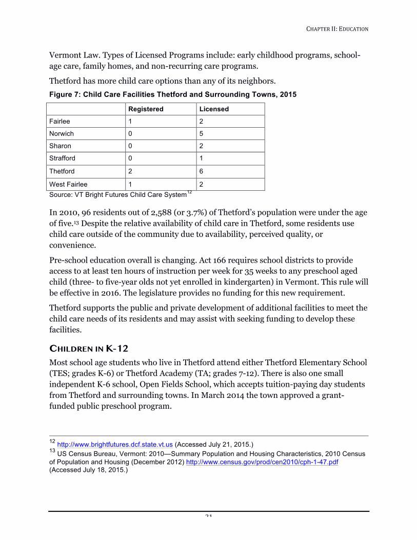
CHAPTER!II:!EDUCATION!!
21!
Vermont Law. Types of Licensed Programs include: early childhood programs, school-age care, family homes, and non-recurring care programs.
Thetford has more child care options than any of its neighbors. Figure 7: Child Care Facilities Thetford and Surrounding Towns, 2015
Registered Licensed
Fairlee 1 2
Norwich 0 5
Sharon 0 2
Strafford 0 1
Thetford 2 6
West Fairlee 1 2 Source: VT Bright Futures Child Care System12 In 2010, 96 residents out of 2,588 (or 3.7%) of Thetford’s population were under the age of five.13 Despite the relative availability of child care in Thetford, some residents use child care outside of the community due to availability, perceived quality, or convenience.
Pre-school education overall is changing. Act 166 requires school districts to provide access to at least ten hours of instruction per week for 35 weeks to any preschool aged child (three- to five-year olds not yet enrolled in kindergarten) in Vermont. This rule will be effective in 2016. The legislature provides no funding for this new requirement.
Thetford supports the public and private development of additional facilities to meet the child care needs of its residents and may assist with seeking funding to develop these facilities.
CHILDREN IN K-12 Most school age students who live in Thetford attend either Thetford Elementary School (TES; grades K-6) or Thetford Academy (TA; grades 7-12). There is also one small independent K-6 school, Open Fields School, which accepts tuition-paying day students from Thetford and surrounding towns. In March 2014 the town approved a grant-funded public preschool program.
12 http://www.brightfutures.dcf.state.vt.us (Accessed July 21, 2015.) 13 US Census Bureau, Vermont: 2010—Summary Population and Housing Characteristics, 2010 Census of Population and Housing (December 2012) http://www.census.gov/prod/cen2010/cph-1-47.pdf (Accessed July 18, 2015.)
CHAPTER!II:!EDUCATION!!
22!
Governance Public education is the responsibility of Thetford’s citizens organized as the Thetford School District. Voters use Australian ballot, both to vote total School Budget up or down, and to select a five-member Thetford School Board of Directors (the School Board) with responsibility for the education of all students from kindergarten through grade 12. Thetford maintains its own elementary school and designates Thetford Academy as its sole public high school. Thetford Academy serves students in grades 7-12. Students attend other schools only if they or their families pay tuition or the School Board, acting on its own initiative or upon request from parents, determines a child’s best interests are served by attending another school. The designation of Thetford Academy was the result of a town-wide vote, which created the original partnership between Thetford Academy and the Town. From time to time townspeople have placed a warned item on the Town Meeting agenda asking the voters to remove the designation of, or “de-designate”, Thetford Academy. To this point these warned items have not passed.
One important School Board responsibility is to define the town’s goals and outcomes for the education of all their children. In 2011 the School Board adopted a strategic plan for the period 2011-2016. The introduction says, “The Thetford community is strongly committed to the public education of our children from pre-K through 12th grade. This education includes each child’s acquisition of the knowledge, skills and love of learning necessary for each stage of his or her academic development. It also includes the nurturing of each child’s sense of self worth, his or her respect for others, community-mindedness, and overall emotional and physical well-being”.
In addition to defining goals and responsibilities, the School Board of Directors serves as the governing board of the Thetford Elementary School, making all significant management decisions. Management decisions at Thetford Academy are made by the Thetford Academy Board of Trustees. The School Board of Directors has one voting representative on the Thetford Academy Board of Trustees, meets biannually with the Trustees, and collaborates with staff, administration, and Board Trustees from Thetford Academy, especially regarding the transition from 6th grade to Thetford Academy from Thetford Elementary School.
Located on Route 113 in the village of Thetford Hill, Thetford Elementary School is a public school serving students in grades K-6. Anecdotally, Thetford Elementary School has a solid reputation based on experienced teachers, strong special education offerings, and small class size. Thetford’s district schoolhouses were consolidated in 1962 into the Thetford Elementary School on Thetford Hill. In the 1970s and 80s, Thetford Elementary School continued to grow in size and improved its existing facilities. In 2003 the most recent major renovation project was completed, which included a new
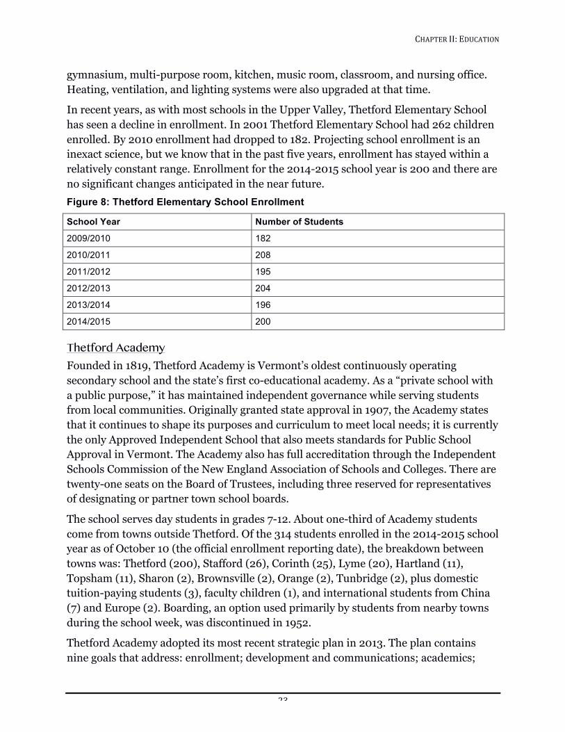
CHAPTER!II:!EDUCATION!!
23!
gymnasium, multi-purpose room, kitchen, music room, classroom, and nursing office. Heating, ventilation, and lighting systems were also upgraded at that time.
In recent years, as with most schools in the Upper Valley, Thetford Elementary School has seen a decline in enrollment. In 2001 Thetford Elementary School had 262 children enrolled. By 2010 enrollment had dropped to 182. Projecting school enrollment is an inexact science, but we know that in the past five years, enrollment has stayed within a relatively constant range. Enrollment for the 2014-2015 school year is 200 and there are no significant changes anticipated in the near future. Figure 8: Thetford Elementary School Enrollment
School Year Number of Students
2009/2010 182
2010/2011 208
2011/2012 195
2012/2013 204
2013/2014 196
2014/2015 200
Thetford Academy Founded in 1819, Thetford Academy is Vermont’s oldest continuously operating secondary school and the state’s first co-educational academy. As a “private school with a public purpose,” it has maintained independent governance while serving students from local communities. Originally granted state approval in 1907, the Academy states that it continues to shape its purposes and curriculum to meet local needs; it is currently the only Approved Independent School that also meets standards for Public School Approval in Vermont. The Academy also has full accreditation through the Independent Schools Commission of the New England Association of Schools and Colleges. There are twenty-one seats on the Board of Trustees, including three reserved for representatives of designating or partner town school boards.
The school serves day students in grades 7-12. About one-third of Academy students come from towns outside Thetford. Of the 314 students enrolled in the 2014-2015 school year as of October 10 (the official enrollment reporting date), the breakdown between towns was: Thetford (200), Stafford (26), Corinth (25), Lyme (20), Hartland (11), Topsham (11), Sharon (2), Brownsville (2), Orange (2), Tunbridge (2), plus domestic tuition-paying students (3), faculty children (1), and international students from China (7) and Europe (2). Boarding, an option used primarily by students from nearby towns during the school week, was discontinued in 1952.
Thetford Academy adopted its most recent strategic plan in 2013. The plan contains nine goals that address: enrollment; development and communications; academics;
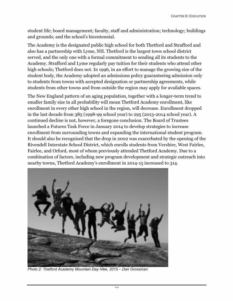
CHAPTER!II:!EDUCATION!!
24!
student life; board management; faculty, staff and administration; technology; buildings and grounds; and the school’s bicentennial.
The Academy is the designated public high school for both Thetford and Strafford and also has a partnership with Lyme, NH. Thetford is the largest town school district served, and the only one with a formal commitment to sending all its students to the Academy. Strafford and Lyme regularly pay tuition for their students who attend other high schools; Thetford does not. In 1996, in an effort to manage the growing size of the student body, the Academy adopted an admissions policy guaranteeing admission only to students from towns with accepted designation or partnership agreements, while students from other towns and from outside the region may apply for available spaces.
The New England pattern of an aging population, together with a longer-term trend to smaller family size in all probability will mean Thetford Academy enrollment, like enrollment in every other high school in the region, will decrease. Enrollment dropped in the last decade from 385 (1998-99 school year) to 295 (2013-2014 school year). A continued decline is not, however, a foregone conclusion. The Board of Trustees launched a Futures Task Force in January 2014 to develop strategies to increase enrollment from surrounding towns and expanding the international student program. It should also be recognized that the drop in 2002 was exacerbated by the opening of the Rivendell Interstate School District, which enrolls students from Vershire, West Fairlee, Fairlee, and Orford, most of whom previously attended Thetford Academy. Due to a combination of factors, including new program development and strategic outreach into nearby towns, Thetford Academy’s enrollment in 2014-15 increased to 314.
!Photo 2: Thetford Academy Mountain Day Hike, 2015 – Dan Grossman
CHAPTER!II:!EDUCATION!!
25!
The Thetford Academy campus is sited on 295 acres on Thetford Hill and is within walking distance of Thetford Elementary School, the Latham Memorial Library, and the Eclipse Grange Theater (home of the Parish Players). The campus includes three primary and a few accessory buildings. The White Building is the oldest and is wood framed. The science building and Anderson/Vaughn Gym are a combination of masonry, concrete and steel framing. The maintenance building is wood frame. There is also one portable classroom.
In 2009 a major capital project was initiated. Work completed to date includes renovating the old gym building to house the new Martha Jane Rich Theater, a cafeteria and refurbished kitchen, and adding a new state-of-the-art gymnasium, the Vaughn Alumni Gymnasium. The science wing was also completely renovated. At the same time Thetford Academy drilled additional wells for their domestic water system, enlarged the existing septic field, and added a new field to enable the school to alternate septic fields annually.
Open Fields School Open Fields School is a small private school located on Academy Road on Thetford Hill, established in 1971. The school serves 18-25 elementary-age students (grades K-6, ages 4-12) and offers a non-competitive, creative, individualized program; exploration of the natural world; and plenty of time outdoors. The building is a three-story wood frame structure with three rooms on the first floor; three classrooms, kitchen and storage room on the second floor; and office space and kitchen on the third floor. The quarter-acre site has parking for 4-6 vehicles, with staff size of three to four full-time teachers and a part-time director. The building is also used occasionally as meeting space for community groups and afterschool programs.
Home Schooling According to the State of Vermont Board of Education a very small percentage of Thetford’s students are home schooled (between 1.5% and 3% in any given year).
Continuing Education In Thetford there are very few options for people who want to complete high school or continue formal or vocational education or engage in organized learning for learning’s sake. Other than the occasional local lecture, Thetford’s residents must look elsewhere. The community is, however, lucky to have a number of local options including the Community College of Vermont, and The River Bend Career and Technical Center. In addition, Dartmouth College offers places in college courses for high school students and The Osher Institute for Life Long Learning. It may be that improved telecommunications (see the Facilities, Services, and Utilities chapter) can provide other opportunities for learning in years to come.
CHAPTER!II:!EDUCATION!!
26!
CHALLENGES Thetford faces three major challenges as we consider educational issues:
1. To continue to prepare Thetford’s youth for the future.
2. To respond effectively to the likely decrease in enrollment in K-12 schools.
3. To determine the best ways to continue to fund public education.
In New England, unlike other parts of the US, education costs are primarily paid with funds raised by property taxes. Short of moving away from a property tax based system of funding for education, there are three things towns can do to decrease the impact of the cost of education on our households.
1. Increase the Grand List, thereby spreading the tax burden over a broader base.
2. Decrease spending.
3. Improve incomes so the property tax is a smaller percentage of taxpayer’s overall budgets.
GOALS, POLICIES, AND RECOMMENDATIONS Goals
1. Support competitively priced child care services and facilities that meet the needs of residents.
2. Continue to provide ever-improving education for all young people, in facilities that meet or exceed the minimum state standards.
3. Improve access for residents to all forms of adult education, including those that enable career change and lifelong learning.
Policies
1. Support the development of additional or improved facilities to meet the childcare needs of residents.
2. Support efforts to seek funding to assist with the development of child care infrastructure.
3. Encourage developers to consider the child care impacts of their new developments.
Recommendations
School and Town administrators should:
1. Work with the Regional Planning Commission to conduct a child care needs assessment.
CHAPTER!II:!EDUCATION!!
27!
2. Continue to cooperate and share recreation and meeting room facilities to maximize public benefits and minimize costs.
3. Continue to support bringing high speed Internet to all parts of Thetford.
The Thetford School Board should assist the Thetford Elementary School and Thetford Academy to:
4. Continue their policy of developing and implementing a capital improvement plan (including annual and long-term plans).
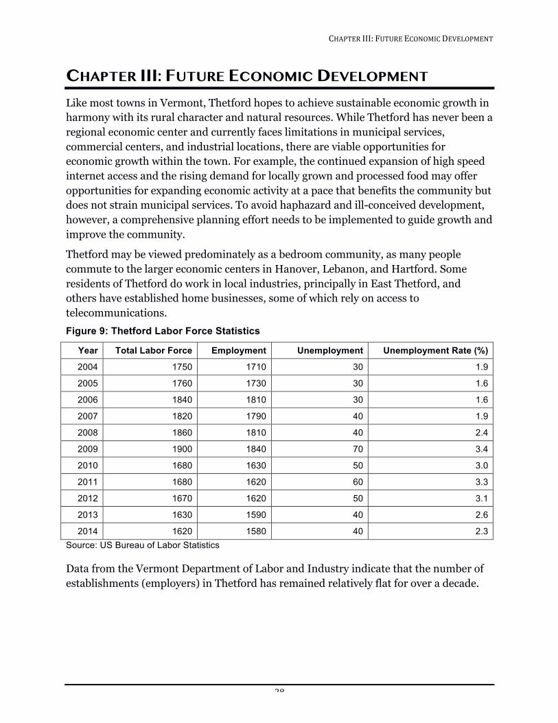
CHAPTER!III:!FUTURE!ECONOMIC!DEVELOPMENT!!
28!
CHAPTER III: FUTURE ECONOMIC DEVELOPMENT Like most towns in Vermont, Thetford hopes to achieve sustainable economic growth in harmony with its rural character and natural resources. While Thetford has never been a regional economic center and currently faces limitations in municipal services, commercial centers, and industrial locations, there are viable opportunities for economic growth within the town. For example, the continued expansion of high speed internet access and the rising demand for locally grown and processed food may offer opportunities for expanding economic activity at a pace that benefits the community but does not strain municipal services. To avoid haphazard and ill-conceived development, however, a comprehensive planning effort needs to be implemented to guide growth and improve the community.
Thetford may be viewed predominately as a bedroom community, as many people commute to the larger economic centers in Hanover, Lebanon, and Hartford. Some residents of Thetford do work in local industries, principally in East Thetford, and others have established home businesses, some of which rely on access to telecommunications. Figure 9: Thetford Labor Force Statistics
Year Total Labor Force Employment Unemployment Unemployment Rate (%)
2004 1750 1710 30 1.9
2005 1760 1730 30 1.6
2006 1840 1810 30 1.6
2007 1820 1790 40 1.9
2008 1860 1810 40 2.4
2009 1900 1840 70 3.4
2010 1680 1630 50 3.0
2011 1680 1620 60 3.3
2012 1670 1620 50 3.1
2013 1630 1590 40 2.6
2014 1620 1580 40 2.3 Source: US Bureau of Labor Statistics Data from the Vermont Department of Labor and Industry indicate that the number of establishments (employers) in Thetford has remained relatively flat for over a decade.
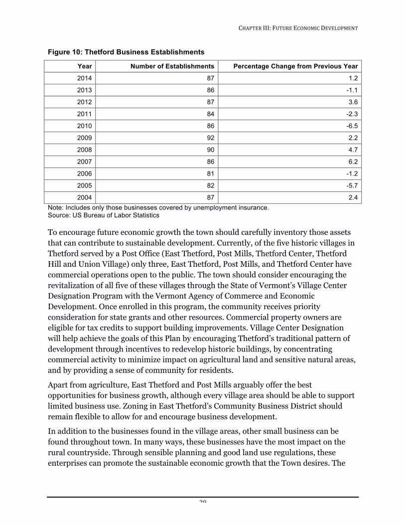
CHAPTER!III:!FUTURE!ECONOMIC!DEVELOPMENT!!
29!
Figure 10: Thetford Business Establishments
Year Number of Establishments Percentage Change from Previous Year
2014 87 1.2
2013 86 -1.1
2012 87 3.6
2011 84 -2.3
2010 86 -6.5
2009 92 2.2
2008 90 4.7
2007 86 6.2
2006 81 -1.2
2005 82 -5.7
2004 87 2.4 Note: Includes only those businesses covered by unemployment insurance. Source: US Bureau of Labor Statistics To encourage future economic growth the town should carefully inventory those assets that can contribute to sustainable development. Currently, of the five historic villages in Thetford served by a Post Office (East Thetford, Post Mills, Thetford Center, Thetford Hill and Union Village) only three, East Thetford, Post Mills, and Thetford Center have commercial operations open to the public. The town should consider encouraging the revitalization of all five of these villages through the State of Vermont’s Village Center Designation Program with the Vermont Agency of Commerce and Economic Development. Once enrolled in this program, the community receives priority consideration for state grants and other resources. Commercial property owners are eligible for tax credits to support building improvements. Village Center Designation will help achieve the goals of this Plan by encouraging Thetford’s traditional pattern of development through incentives to redevelop historic buildings, by concentrating commercial activity to minimize impact on agricultural land and sensitive natural areas, and by providing a sense of community for residents.
Apart from agriculture, East Thetford and Post Mills arguably offer the best opportunities for business growth, although every village area should be able to support limited business use. Zoning in East Thetford’s Community Business District should remain flexible to allow for and encourage business development.
In addition to the businesses found in the village areas, other small business can be found throughout town. In many ways, these businesses have the most impact on the rural countryside. Through sensible planning and good land use regulations, these enterprises can promote the sustainable economic growth that the Town desires. The
CHAPTER!III:!FUTURE!ECONOMIC!DEVELOPMENT!!
30!
community will continue to encourage the development of small businesses as long as they do not negatively impact the rural character of Thetford and are at a size and a scale to exist harmoniously with surrounding homes and other businesses. The burden placed on municipal services, especially roads, by these businesses should be considered and avoided when possible. Commercial “sprawl” or “strip development” is not consistent with the character of the community. Specifically, the intersection of Interstate 91 and Route 113 should not be developed so that we may protect Thetford’s rural character and maintain and encourage the vitality of our village centers.
Thetford does not have a local chamber of commerce or business association, but the Upper Valley Chamber of Commerce includes Thetford as part of its region. The Dartmouth Entrepreneurial Network is a resource for innovative and local business support. Ideas for future business initiatives include agricultural processing facilities where local produce and meat can be canned, cured, butchered, etc. This would raise incomes for farmers, conserve energy spent on transportation, and make local agricultural products more available. A food-processing center could create local jobs in three ways: increasing on-farm opportunities as demand rises, enabling food related businesses to grow, and providing employment at the facility itself. A food-processing facility could be a hub for economic development in this community, as it could support micro-businesses as well as home-based operations.
Leadership in this process is needed to achieve Thetford’s goals for future economic growth. A coordinated effort from key figures in the community, such as small business owners, realtors, and Thetford Academy and Town representatives, is needed to form the consensus necessary for successful economic development. That process should begin by identifying the commercial needs of the Town and whether they can be realistically offered locally. Using this information, the Town should develop specific plans to guide future economic growth.
GOALS, POLICIES AND RECOMMENDATIONS Goals
1. Strengthen the identity and economic vitality of Thetford and its villages.
2. Encourage a strong and diverse local economy that provides satisfying and rewarding employment opportunities for residents while maintaining the community’s rural character.
3. Encourage businesses that do not endanger natural resources and integrate them into villages.
4. Encourage land use that helps create a sustainable local jobs that pay a living wage, enabling workers to live in Thetford.
CHAPTER!III:!FUTURE!ECONOMIC!DEVELOPMENT!!
31!
5. Encourage an inter-generational population, with housing, education, activities, and employment opportunities for a wide range of ages.
Policies
1. Encourage businesses that contribute to mixed-use village life and services.
2. Encourage home and small businesses in rural areas.
3. Encourage agricultural operations and food processing facilities that foster growth of local food sources.
4. Actively support the expansion of broadband services to all homes and businesses in town.
5. Review industrial and commercial uses with careful attention to their environmental impacts, building size and effect on traffic.
Recommendations
1. The Town should apply for Village Designation for one or more of the five village areas to give local developers and business owners access to tax credits for revitalization.
2. The Town should revise the village district boundary for Thetford Hill to exclude the Interstate 91 intersection.
3. The Town should create a new zoning district that allows differentiation between the village center of Post Mills and the extended village residential area (“neighborhood residential” designation).
4. The Town should encourage development in Thetford’s village areas to be sensitive to the visual aesthetic of the traditional Vermont town.
5. The Town should encourage and support the responsible development of information technology and communications infrastructure necessary for new economic growth.
CHAPTER!IV:!FACILITIES,!SERVICES,!AND!UTILITIES!!
32!
CHAPTER IV: FACILITIES, SERVICES, AND UTILITIES Community facilities are physical assets such as the Town Hall and town roads. Community services include health, safety, recreation, and other programs that serve the town’s residents. They are generally administered by a town department or nonprofit organization, but may include private operations. Community utilities may combine both facilities and services through an organization that delivers a commodity such as water. Funding for the operation of these facilities, services, and utilities is usually through the Town’s General Budget, although it is not uncommon for user fees to be a source of funding. Education is covered in another chapter of this Plan.
The extent and adequacy of community facilities, services, and utilities, whether publicly or privately operated, play an important role by contributing to the general welfare of residents and the quality of life in town and by attracting certain types of development to the community. The demand is not static. Existing facilities may become inadequate through structural deterioration or functional obsolescence as well as through increased or new demands that accompany population growth and changes in lifestyles.
To plan for future needs, it is necessary to inventory existing facilities, examine their needs, and project future costs for upkeep. It should be noted that the primary concern in this Town Plan is with physical facilities and not with operating programs. The suitability of the existing facilities, services, and utilities to meet future demands will also be considered.
TOWN AND COMMUNITY FACILITIES
1. Town Hall The Thetford Town Hall is located on Route 113 in Thetford Center. Originally built in 1830 as a one-story red brick meeting hall, it is listed on the National Register of Historic Places. In the 1960s the building was renovated to add offices for the Town Clerk, Town Treasurer, Listers, Zoning Administration, Selectboard, Food Shelf, Records Vault, and eventually the Police Department. In 2003 a major renovation was funded by bond vote to restore and refurbish the original meeting hall and adjacent historic red brick Wallace Vault. A wood frame addition was built to join both brick buildings and provide additional office and storage space, doubling the size of the original facility. The meeting hall is used frequently for public hearings by the Selectboard, Planning Commission, Conservation Commission, and other Town departments, and for community activities such as voting and political caucuses.
Thetford’s Town Hall is now centrally wired for voice and data communications providing for computerized functions for all Town offices and for public access. The
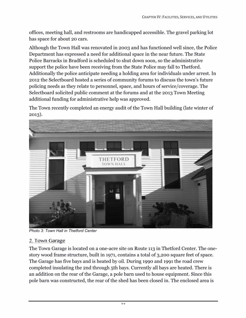
CHAPTER!IV:!FACILITIES,!SERVICES,!AND!UTILITIES!!
33!
offices, meeting hall, and restrooms are handicapped accessible. The gravel parking lot has space for about 20 cars.
Although the Town Hall was renovated in 2003 and has functioned well since, the Police Department has expressed a need for additional space in the near future. The State Police Barracks in Bradford is scheduled to shut down soon, so the administrative support the police have been receiving from the State Police may fall to Thetford. Additionally the police anticipate needing a holding area for individuals under arrest. In 2012 the Selectboard hosted a series of community forums to discuss the town’s future policing needs as they relate to personnel, space, and hours of service/coverage. The Selectboard solicited public comment at the forums and at the 2013 Town Meeting additional funding for administrative help was approved.
The Town recently completed an energy audit of the Town Hall building (late winter of 2013).
!Photo 3: Town Hall in Thetford Center
2. Town Garage The Town Garage is located on a one-acre site on Route 113 in Thetford Center. The one-story wood frame structure, built in 1971, contains a total of 3,200 square feet of space. The Garage has five bays and is heated by oil. During 1990 and 1991 the road crew completed insulating the 2nd through 5th bays. Currently all bays are heated. There is an addition on the rear of the Garage, a pole barn used to house equipment. Since this pole barn was constructed, the rear of the shed has been closed in. The enclosed area is
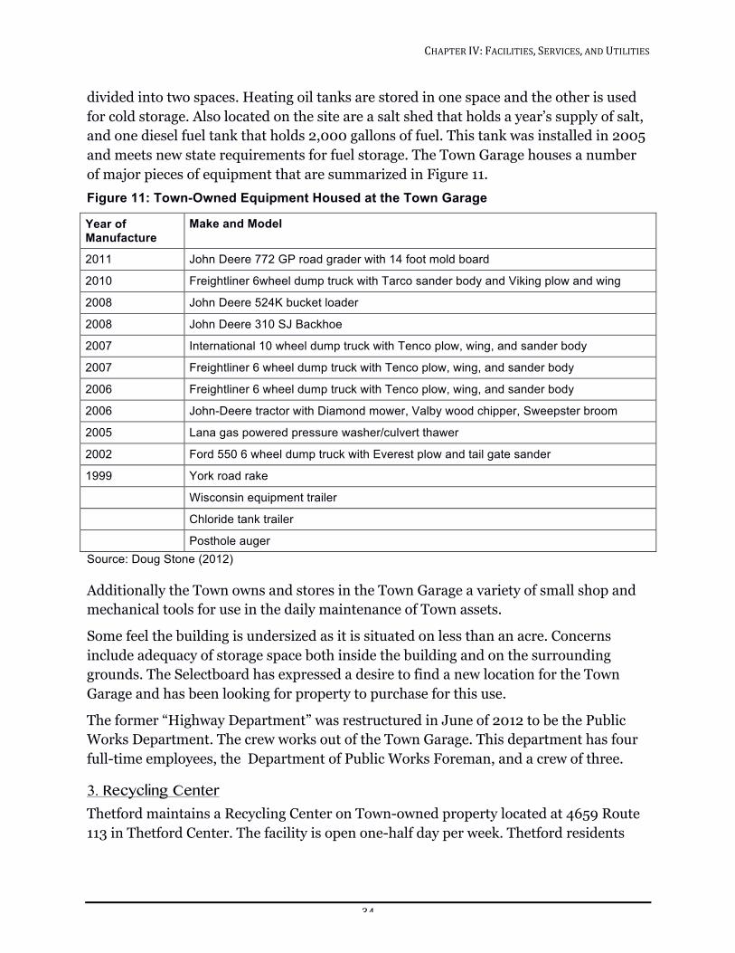
CHAPTER!IV:!FACILITIES,!SERVICES,!AND!UTILITIES!!
34!
divided into two spaces. Heating oil tanks are stored in one space and the other is used for cold storage. Also located on the site are a salt shed that holds a year’s supply of salt, and one diesel fuel tank that holds 2,000 gallons of fuel. This tank was installed in 2005 and meets new state requirements for fuel storage. The Town Garage houses a number of major pieces of equipment that are summarized in Figure 11. Figure 11: Town-Owned Equipment Housed at the Town Garage
Year of Manufacture
Make and Model
2011 John Deere 772 GP road grader with 14 foot mold board
2010 Freightliner 6wheel dump truck with Tarco sander body and Viking plow and wing
2008 John Deere 524K bucket loader
2008 John Deere 310 SJ Backhoe
2007 International 10 wheel dump truck with Tenco plow, wing, and sander body
2007 Freightliner 6 wheel dump truck with Tenco plow, wing, and sander body
2006 Freightliner 6 wheel dump truck with Tenco plow, wing, and sander body
2006 John-Deere tractor with Diamond mower, Valby wood chipper, Sweepster broom
2005 Lana gas powered pressure washer/culvert thawer
2002 Ford 550 6 wheel dump truck with Everest plow and tail gate sander
1999 York road rake
Wisconsin equipment trailer
Chloride tank trailer
Posthole auger Source: Doug Stone (2012) Additionally the Town owns and stores in the Town Garage a variety of small shop and mechanical tools for use in the daily maintenance of Town assets.
Some feel the building is undersized as it is situated on less than an acre. Concerns include adequacy of storage space both inside the building and on the surrounding grounds. The Selectboard has expressed a desire to find a new location for the Town Garage and has been looking for property to purchase for this use.
The former “Highway Department” was restructured in June of 2012 to be the Public Works Department. The crew works out of the Town Garage. This department has four full-time employees, the Department of Public Works Foreman, and a crew of three.
3. Recycling Center Thetford maintains a Recycling Center on Town-owned property located at 4659 Route 113 in Thetford Center. The facility is open one-half day per week. Thetford residents
CHAPTER!IV:!FACILITIES,!SERVICES,!AND!UTILITIES!!
35!
wishing to use the Town’s Recycling Center, for trash or recycling must purchase a permit. Permits are available at Town Hall during regular business hours.
The Recycling Center is in a functional location, although there are some constraints on the site due to setback requirements and the size of the parcel on which it is located. Because of the limited hours of operation, traffic problems can arise as many in the community seek to use the facility during the three and a half-hour open period. Since 2008 the town has been setting aside $5,000 per year into a capital reserve fund to support broad based infrastructure improvements. Should a property become available that is deemed better for the recycling and waste needs of the town, this money could be used in support of that purchase.
4. Libraries The Thetford Library Federation, formed in the late 1960s, is a coordinated group representing the Elementary School and Academy libraries, Latham and Peabody libraries, and the Thetford Historical Society Library. Latham (Thetford Hill) and Peabody (Post Mills) are the two public libraries in the Federation. Each library has its own board of directors and makes its own policies, but through the Federation resources and funding are shared. The Federation board consists of representatives from each of the member institutions. Latham Library serves both as a town library and a library for the First Congregational Church. Originally, the Latham board was made up solely of church members, but at one point in its history, it was merged with the town library board. The North Thetford Library chose to remain independent of the Federation. It does not ask the Town for any funding.
PEABODY LIBRARY
The George Peabody Library is located on Route 113 in Post Mills. Built in 1867, this wood frame, clapboarded and gable-roofed structure is on the National Register of Historic Places. A warm air and circulating liquid system heats the building. This building has no potable water, but does have an electric toilet facility. A major renovation of the library was completed in 2002 with funding from bequests and from the Freeman Foundation. Its collection includes some of the original volumes purchased in 1867, a collection of American fiction and an expanding collection of materials for children. The current part-time Children’s Librarian hosts about fifty programs a year in the library as well as a number of programs each summer at Treasure Island.
The library staff consists of a part-time Librarian with a professional degree and a part-time Children’s Librarian. The Peabody Library is particularly noteworthy as the oldest library building in Vermont still functioning as a public library.
CHAPTER!IV:!FACILITIES,!SERVICES,!AND!UTILITIES!!
36!
BICENTENNIAL BUILDING
Built in 1975 by the Thetford Library Federation, the Bicentennial Building on Thetford Hill houses the Thetford Historical Society and Latham Memorial Library. The building was constructed through private fundraising and with the help of the first federal building grant honoring the nation’s bicentennial. The building, which is heated with oil, is handicapped-accessible and includes a reading room, workroom, two vaults, and an exhibit room. The historical collection includes 2,500 volumes that do not circulate. The two collections together include over 13,000 volumes, 40 manuscript collections, a genealogical file, photographs and glass negatives, framed portraits and paintings. Genealogical research, preschool story hour, art exhibits, an after school teen space, and programs for all ages are offered in the building. Thanks to volunteers, the library can be kept open more hours and provide a level of service beyond what two part-time librarians can provide. In February 2013, much needed new computers were installed in the building.
The Town annually appropriates an amount of money to cover the operating costs of the Bicentennial Building and provides some funding for Peabody Library and Latham Memorial Library. Investment income from an annual giving campaign and donations fund the Library Federation’s other activities.
THE NORTH THETFORD LIBRARY
Located on Route 5 in North Thetford, the North Thetford Library as of this writing is inactive. The lower level of the building is currently being used for a daycare.
5. Cemeteries Thetford has 14 cemeteries distributed throughout town. Of these, two cemeteries are privately owned, Thetford Center and Post Mills. Along with North Thetford, these three are the only cemeteries with available space.
Responding to a request from the Evergreen Cemetery Board, the Cemetery Commission is weighing the possibility of taking over the Thetford Center (new) cemetery as a Town cemetery.
The Town anticipates the likelihood of adding additional cemeteries as older cemeteries with no management ask to become part of the Town system.
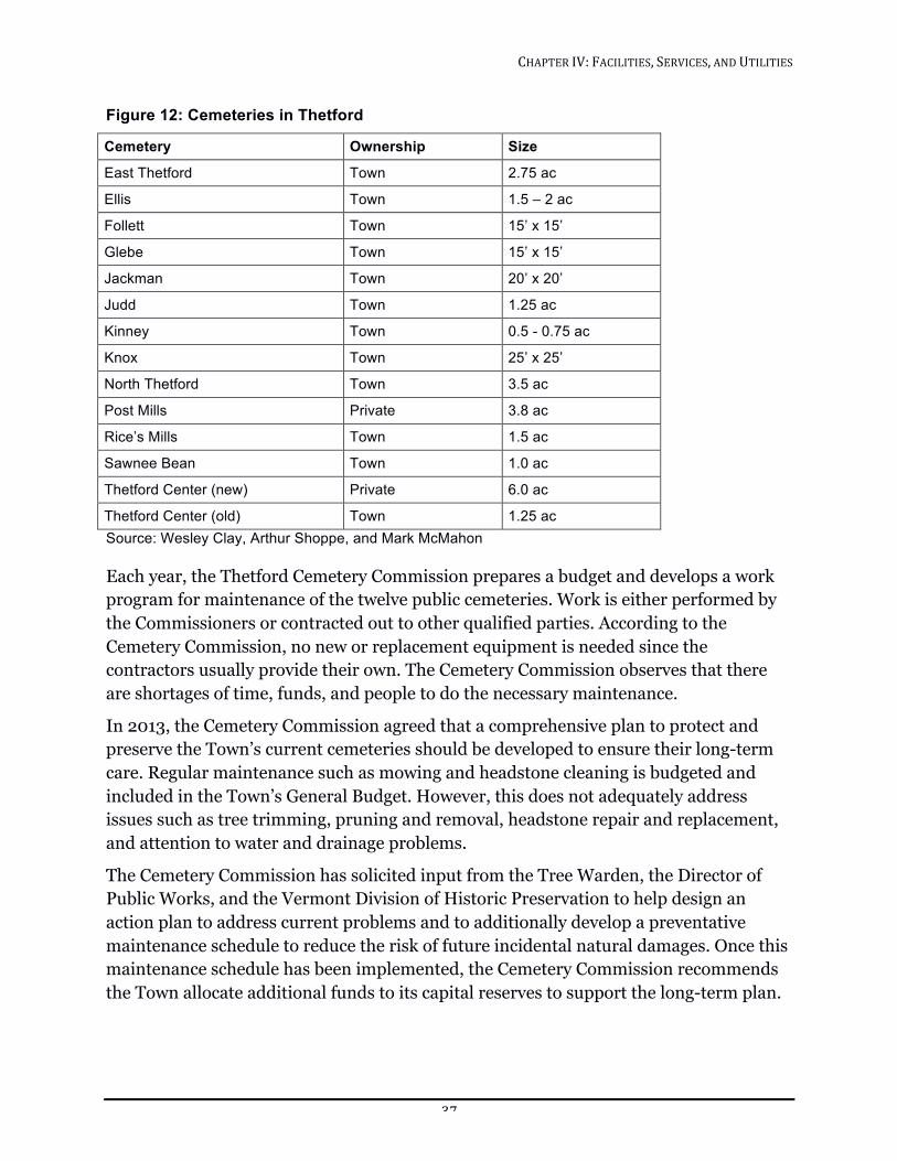
CHAPTER!IV:!FACILITIES,!SERVICES,!AND!UTILITIES!!
37!
Figure 12: Cemeteries in Thetford
Cemetery Ownership Size
East Thetford Town 2.75 ac
Ellis Town 1.5 – 2 ac
Follett Town 15’ x 15’
Glebe Town 15’ x 15’
Jackman Town 20’ x 20’
Judd Town 1.25 ac
Kinney Town 0.5 - 0.75 ac
Knox Town 25’ x 25’
North Thetford Town 3.5 ac
Post Mills Private 3.8 ac
Rice’s Mills Town 1.5 ac
Sawnee Bean Town 1.0 ac
Thetford Center (new) Private 6.0 ac
Thetford Center (old) Town 1.25 ac Source: Wesley Clay, Arthur Shoppe, and Mark McMahon Each year, the Thetford Cemetery Commission prepares a budget and develops a work program for maintenance of the twelve public cemeteries. Work is either performed by the Commissioners or contracted out to other qualified parties. According to the Cemetery Commission, no new or replacement equipment is needed since the contractors usually provide their own. The Cemetery Commission observes that there are shortages of time, funds, and people to do the necessary maintenance.
In 2013, the Cemetery Commission agreed that a comprehensive plan to protect and preserve the Town’s current cemeteries should be developed to ensure their long-term care. Regular maintenance such as mowing and headstone cleaning is budgeted and included in the Town’s General Budget. However, this does not adequately address issues such as tree trimming, pruning and removal, headstone repair and replacement, and attention to water and drainage problems.
The Cemetery Commission has solicited input from the Tree Warden, the Director of Public Works, and the Vermont Division of Historic Preservation to help design an action plan to address current problems and to additionally develop a preventative maintenance schedule to reduce the risk of future incidental natural damages. Once this maintenance schedule has been implemented, the Cemetery Commission recommends the Town allocate additional funds to its capital reserves to support the long-term plan.
CHAPTER!IV:!FACILITIES,!SERVICES,!AND!UTILITIES!!
38!
Finally, as Thetford’s population ages, the town will have to consider either purchasing additional property or consider using existing Town-owned property to provide additional cemetery space.
6. Churches The town of Thetford has a church in every village. The churches serve as both religious and social gathering places. Each church hosts a number of activities other than church services. Among these are important social services such as the WIC (Women, Infants, and Children) program and monthly senior meals hosted by the Thetford Elder Network (TEN). If the churches were not available for use as meeting places, Thetford would lack sufficient public assembly spaces and the sense of village character would be undermined without a place for people to gather in each neighborhood. Additionally, the churches are prominent structures in the villages, which contribute significantly to the village character.
The Thetford Baptist Church (East Thetford) was established in 1982. The church building has an interesting history. It was originally constructed in Cambridgeport Vermont, in 1836. The building was dismantled, moved, and reconstructed in East Thetford in 1985. The building has no known structural or systemic problems.
The First Congregational Church in Thetford, VT, United Church of Christ (Thetford Hill) was established in 1773. The first services were held in a log building on Garey Road. The church on Thetford Hill was constructed in 1787. It is notable as the oldest meetinghouse in the state still in continuous use. Today, in addition to church-related functions and a variety of social activities, Maple Leaf Day Care uses the facility.
The United Church of Thetford was formed in 2008 by the merger of the former North Thetford Federated Church and the Timothy Frost United Methodist Church in Thetford Center. The United Church continues to use and maintain two buildings—one in North Thetford and one in Thetford Center. The North Thetford church dates from 1860, with additions in 1900 and 1958. Serving a United Church of Christ and United Methodist congregation, the structure is believed to be unique, as it is thought to be the only church in North America with a gold leaf covered pineapple at the top of the steeple. The pineapple is a symbol of friendship and hospitality. There is also a large fellowship hall with a stage and fully equipped kitchen that is available to the community. The Thetford Elder Network holds monthly luncheons at the North Thetford church building.
Built in 1836, the Timothy Frost Methodist Church in Thetford Center was named after an early minister. The church has no running water and the nearby Thetford Center Community Building provides kitchen and bathroom facilities for church functions The Methodist Church has benefitted from grants for clock conservation.

CHAPTER!IV:!FACILITIES,!SERVICES,!AND!UTILITIES!!
39!
The Post Mills Congregational Church was begun in 1818 and interior work was completed in 1828. In addition to year-round residents, campers from the youth camps on Lake Fairlee attend summer church services. The Post Mills Congregational Church has a kitchen and a spacious utility room in the basement, currently used by Caring Communities Preschool.
7. Public Gathering Places Thetford’s historical pattern of settlement, many small villages, has left a legacy of public and institutional structures scattered throughout the town. These include: the Thetford Center Community Building, Rice’s Mills Community Building, and the Eclipse Grange and American Legion Hall on Thetford Hill. These structures are important architecturally, visually, and historically. Each is included in the Vermont Historic Sites and Structures Survey. The American Legion Hall and Eclipse Grange are included in the Thetford Hill National Register Historic District. The Thetford Center Community Building has been nominated as part of the Thetford Center National Historic District. These buildings should be used either for community activities or privately, as long as their appearance is not altered significantly. They contribute to the town’s sense of the past and to the available community spaces.
The Thetford Center Community Building was built c. 1870 and served Thetford School District #8. It is used now by the Thetford Center Community Association and is rented out for local activities such as yoga.
Built c. 1928, the Rice’s Mills Community Building was used as a schoolhouse until the construction of the Elementary School on Thetford Hill. In 1961, 12 families bought the building from the town. In the past few years the community association has made substantial repairs, including replacing the roof. This building is used for recreation, such as dancing, and frequently hosts pot luck suppers.
The American Legion Hall was built in 1910 and was the last schoolhouse to serve District #10. Its use as a school was discontinued in 1945 and it was sold to the American Legion in 1952.
The Elementary School and Thetford Academy, as discussed in other sections of this Plan, are also used for community activities.
TOWN AND COMMUNITY SERVICES Unlike urban areas, which frequently offer many services such as sewer and water, Thetford is rural and sparsely populated. Most households have their own well and septic systems. The beyond the educational system, primary services offered by the community are road maintenance, emergency services, and solid waste removal. There are no public water or sewer systems in Thetford. There are several private water systems active in the community.
CHAPTER!IV:!FACILITIES,!SERVICES,!AND!UTILITIES!!
40!
1. Water Supplies Thetford has several community water systems that supply water for domestic purposes. All have aquifer protection areas that must be located before contaminants such as fertilizer, insecticides, or herbicides are applied nearby.
THETFORD HILL
The Thetford Water Cooperative, Inc. provides water to 41 residences and 7 community organizations on Thetford Hill. The Cooperative draws water from two drilled wells. A 500’ well was drilled in 2001 and served as the primary water source until 2010 when a second well approximately 700’ deep was drilled and now has the “primary source” designation. Together, the wells produce 18 gallons per minute. Both wells are located in the Houghton Hill State Forest and the Cooperative possesses a water rights easement for this land. The Houghton Hill land was donated by Dwight Goddard in 1931 for the purpose of providing water to the village.
Water from the wells is pumped to two 10,000-gallon tanks and is gravity fed from these reservoirs to the users, providing on average 6000 gallons of water per day to all users combined. Water quality is monitored through scheduled testing set by the State of Vermont. With two drilled wells now in place the Cooperative presently exceeds the state’s supply requirements for the number of users.
An annual fee of $550 is assessed for each connection to the Cooperative’s water main. Additional connections have to be approved by the Thetford Water Cooperative Board of Directors and the State of Vermont. A source protection plan for the Cooperative’s wells is on file with the State of Vermont. Aquifer protection areas are shown on Natural Resources Map and Water Features Map.
NORTH THETFORD
The North Thetford Union Water Company serves approximately 23 households. A bedrock spring is tapped to provide water that is gravity fed. The water is chlorinated. Users are unmetered and pay an annual fee of $60.
The North Thetford Water Company split into two water companies in 1995—the North Village Water Company and the South Village Water Company. There are 11-12 connections for each water company.
EAST THETFORD
The East Thetford Water Company serves approximately 40 residences. A new well was provided for the water company in 1990 by the Vermont Agency of Transportation whose salt shed, which was up-gradient of the original water source, may have been leaching sodium into the water. The new well is on top of Cobble Hill on land owned by Vaughan Farms. This well has a large capacity and could easily serve more residences. The water is treated for iron and manganese and is chlorinated.
CHAPTER!IV:!FACILITIES,!SERVICES,!AND!UTILITIES!!
41!
POST MILLS
A new well was drilled to supply nine residences near the old landfill in Post Mills. The system was installed by the Vermont Agency of Natural Resources using funds collected through a legal action against the Upper Valley Regional Landfill Corporation. The legal action was a consequence of the pollution of local private wells by the landfill. This private water system has been built to public water supply standards and has a designated protection area as it may become public in the future. The system is owned and run by the Post Mills Water Association. The well that serves the system is located on a 104-acre parcel that abuts the landfill parcel. This parcel is owned by the Town of Thetford with an easement that protects the land from development and will help to ensure a continuing source of clean water for the water system.
2. Sanitary Sewer In Thetford all sewage, whether domestic, institutional, or industrial, is disposed of by means of on-site systems. At present there are no areas with sufficient density of housing to warrant the construction of a sewage treatment plant. On-site systems will remain the sole method of sewage disposal for the foreseeable future in Thetford. For this reason, the feasibility of creating building lots hinges, to a large extent, on the land’s capability of handling sewage and, at the same time, providing an adequate and safe supply of water for domestic usage.
Since the last revision of this Plan, state law has changed the way towns may regulate and permit septic systems. As of July 1, 2007 septic regulations in all towns in Vermont were superseded by new state rules. These rules have more lenient site requirements than did the Thetford rules, which will increase the amount of land in Thetford where septic systems may be permitted. This legislation was enacted to ensure that the design and technical standards for potable water supplies and wastewater systems be uniform statewide. By statute, a municipality cannot adopt more stringent design and technical standards for septic systems and potable water supplies.
3. Septage Septage, the material that is pumped from septic tanks, must be disposed of. Approximately 125,000 gallons are generated annually in Thetford. Haulers dispose of the septage at several treatment plants, depending on location and disposal fees. The Town has no real control over the ultimate disposal location of septage. One Thetford hauler reports that the septage he collects from Thetford is deposited in their state permitted septage lagoon. Ultimately in accordance with the permit it is spread on the land at a local farm.
Land application of septage is a common disposal method. Both the nutrient and water content of septage can benefit the land on which it is spread. The risks of surface and groundwater contamination are drawbacks to land spreading. Careful site selection and
CHAPTER!IV:!FACILITIES,!SERVICES,!AND!UTILITIES!!
42!
responsible site management can substantially reduce these risks. Septage spreading is not permitted when the ground is wet, frozen, or snow-covered. Recently, there has been an increase in concern over septage spreading because research has revealed that new substances are showing up in sewage containing personal care products and pharmaceuticals. The future of septage spreading is uncertain.
Currently, the lowest cost disposal option for septage haulers is through privately owned permitted lagoons and spreading sites. Co-treatment with sewage at a wastewater treatment plant is the other option, but involves higher operating and maintenance costs and potentially additional transportation costs for haulers. The septage disposal location is selected by the individual septage hauler that contracts with the individual homeowner, and is based on economics. Should land application permitting become more stringent, increasing the costs for operating the septage lagoons and land application, there will likely be an increase in the volume of septage disposed of at local wastewater treatment facilities, including Hanover NH.
Each year the Town of Thetford signs a non-binding contract with the Town of Hanover for the option to dispose of septage from Thetford. Historically very little septage from Thetford has been disposed of at the Hanover Wastewater Treatment Facility but the contract ensures that the option remains open. The septage facilities at the Hanover Wastewater Treatment Facility co-mingle the septage with the treatment plant sludge for disposal at the Lebanon Landfill.
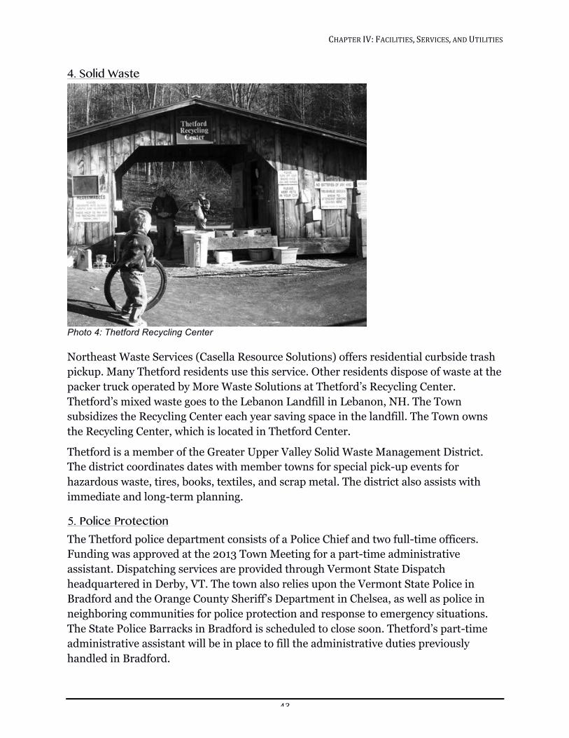
CHAPTER!IV:!FACILITIES,!SERVICES,!AND!UTILITIES!!
43!
4. Solid Waste
!Photo 4: Thetford Recycling Center
Northeast Waste Services (Casella Resource Solutions) offers residential curbside trash pickup. Many Thetford residents use this service. Other residents dispose of waste at the packer truck operated by More Waste Solutions at Thetford’s Recycling Center. Thetford’s mixed waste goes to the Lebanon Landfill in Lebanon, NH. The Town subsidizes the Recycling Center each year saving space in the landfill. The Town owns the Recycling Center, which is located in Thetford Center.
Thetford is a member of the Greater Upper Valley Solid Waste Management District. The district coordinates dates with member towns for special pick-up events for hazardous waste, tires, books, textiles, and scrap metal. The district also assists with immediate and long-term planning.
5. Police Protection The Thetford police department consists of a Police Chief and two full-time officers. Funding was approved at the 2013 Town Meeting for a part-time administrative assistant. Dispatching services are provided through Vermont State Dispatch headquartered in Derby, VT. The town also relies upon the Vermont State Police in Bradford and the Orange County Sheriff’s Department in Chelsea, as well as police in neighboring communities for police protection and response to emergency situations. The State Police Barracks in Bradford is scheduled to close soon. Thetford’s part-time administrative assistant will be in place to fill the administrative duties previously handled in Bradford.
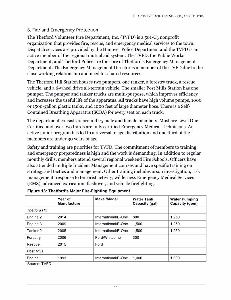
CHAPTER!IV:!FACILITIES,!SERVICES,!AND!UTILITIES!!
44!
6. Fire and Emergency Protection The Thetford Volunteer Fire Department, Inc. (TVFD) is a 501-C3 nonprofit organization that provides fire, rescue, and emergency medical services to the town. Dispatch services are provided by the Hanover Police Department and the TVFD is an active member of the regional mutual aid system. The TVFD, the Public Works Department, and Thetford Police are the core of Thetford’s Emergency Management Department. The Emergency Management Director is a member of the TVFD due to the close working relationship and need for shared resources.
The Thetford Hill Station houses two pumpers, one tanker, a forestry truck, a rescue vehicle, and a 6-wheel drive all-terrain vehicle. The smaller Post Mills Station has one pumper. The pumper and tanker trucks are multi-purpose, which improves efficiency and increases the useful life of the apparatus. All trucks have high volume pumps, 1000 or 1500-gallon plastic tanks, and 1000 feet of large diameter hose. There is a Self-Contained Breathing Apparatus (SCBA) for every seat on each truck.
The department consists of around 25 male and female members. Most are Level One Certified and over two thirds are fully certified Emergency Medical Technicians. An active junior program has led to a reversal in age distribution and one third of the members are under 30 years of age.
Safety and training are priorities for TVFD. The commitment of members to training and emergency preparedness is high and the work is demanding. In addition to regular monthly drills, members attend several regional weekend Fire Schools. Officers have also attended multiple Incident Management courses and have specific training on strategy and tactics and management. Other training includes arson investigation, risk management, response to terrorist activity, wilderness Emergency Medical Services (EMS), advanced extrication, flashover, and vehicle firefighting. Figure 13: Thetford’s Major Fire-Fighting Equipment
Year of Manufacture
Make /Model Water Tank Capacity (gal)
Water Pumping Capacity (gpm)
Thetford Hill
Engine 2 2014 International/E-One 800 1,250
Engine 3 2009 International/E-One 1,500 1,250
Tanker 2 2005 International/E-One 1,500 1,250
Forestry 2006 Ford/Whitcomb 300
Rescue 2015 Ford
Post Mills
Engine 1 1991 International/E-One 1,000 1,000 Source: TVFD
CHAPTER!IV:!FACILITIES,!SERVICES,!AND!UTILITIES!!
45!
The lack of an adequate water supply is a major hindrance to effective fire protection in some areas town. The Fire Insurance Underwriter’s Bureau, an agency that establishes the level of rate coverage for community fire insurance, places a 60 percent emphasis upon water supply and a 40 percent emphasis on available equipment. For residential properties, the Bureau requires a water flow of 500 gallons per minute for a two-hour duration and somewhat greater volume and duration for commercial, industrial, and agricultural properties. The majority of properties in Thetford are within 3,000 feet of an existing water supply, however, many supplies are inadequate in summer, inaccessible in winter, or do not have access via a dry hydrant. The Fire Insurance Underwriter’s Bureau recently revised Thetford’s Public Protection Classification (PPC) upward, from 9 to 8b. The PPC uses a scale from 1 to 10, with 1 being the best and 10 being the worst rating. (For information on the rating system see: http://www.isomitigation.com/ppc/2000/ppc2004.html#.ULLctGfci6s.)
The feasibility of developing an improved system of water supply, via underground water mains, has been investigated, however the expense associated with providing such service to six widely separated villages proved to be too great. At the present time, Thetford is the only town on the west bank of the Connecticut River from Wells River to Hartford that does not provide underground water mains for fire protection. As a partial remedy to this situation, the town voted at Town Meeting in 1992 to begin raising funds for the Fire Department to install dry hydrants in existing ponds at key locations around town. This plan has been successful. The town now has close to twenty dry hydrants.
TVFD maintains an overall strategy that includes replacing a truck every eight years, putting the newest pumper on Thetford Hill, the older pumper in Post Mills, and converting the oldest pumper into a tanker. Every few years, townspeople vote at Town Meeting whether to authorize a new truck purchase. All maintenance and truck conversions are paid for with TVFD fund raising.
7. Emergency Medical Services
THETFORD FAST SQUAD
Emergency medical calls are answered initially by the Thetford FAST Squad, which is a part of the Fire Department. There are approximately 18 Fire Department members trained at a minimum of the EMT level with 6 members being trained at the Advanced EMT level. The purpose of the FAST Squad is to provide immediate response to emergencies while an ambulance from Upper Valley Ambulance is on route to the accident or situation. (FAST stands for First Aid Stabilization Team.) The budget for the FAST squad is included as part of the Fire Department budget and there is not a separate line item in the Town Budget.
CHAPTER!IV:!FACILITIES,!SERVICES,!AND!UTILITIES!!
46!
UPPER VALLEY AMBULANCE
Located in Fairlee, VT, the Upper Valley Ambulance, Inc. (UVA) is a not for profit emergency ambulance and rescue service composed of paid full-time staff. UVA covers an area consisting of nine towns in Vermont, including Thetford, and several towns in New Hampshire. In addition to emergency services, UVA offers non-emergency services including transportation to hospitals, nursing homes, and other residences as well as training in CPR (cardiopulmonary resuscitation) and first aid.
8. Emergency Planning in Thetford Thetford maintains an Emergency Management Director who is one of its appointed officers. The role of this individual is to coordinate local and regional emergency services and to ensure that the town is prepared in the event of an emergency. The Town keeps an up-to-date Emergency Operations Plan as well as a Basic Emergency Operations Plan. These tools establish the chain of command during major emergencies and provide local officials with the information they need to safely handle such difficult situations. Thetford Elementary School has been designated the Town’s emergency shelter.
9. Health Care Facilities Health care facilities are essential in the prevention, treatment, and management of illness, and in the preservation of mental and physical well-being through the services they offer. Rural locations such as Thetford are served by small facilities that can assist residents with general health care needs but are not suited for more complex acute care services that require specialized service and equipment.
The low population density of Vermont’s rural countryside and the large area over which the population is distributed can make providing adequate health care difficult, particularly for the elderly who may not be able to drive themselves to major health care facilities. Likewise in rural areas, emergency care for severe trauma or major acute illnesses such as stroke and heart attack may take longer to arrive than in more populated locations, risking potential loss of life.
Thetford is home to The Center for Sustainable Medicine where homeopathy and acupuncture are two of the practices offered. There are a number of smaller health clinics located in neighboring towns such as Lyme, Chelsea, Sharon and Hartford. Alice Peck Day, located in Lebanon NH, and Gifford Medical Center, located in Randolph, offer a wide range of services to address most medical needs. Dartmouth-Hitchcock Medical Center, a tertiary care facility and the largest medical center in Northern New England, is located in Lebanon NH.
The Thetford Elder Network and the Ompompanoosuc Community Trust are exploring the model of a community nurse, in part to help meet the needs of our senior neighbors
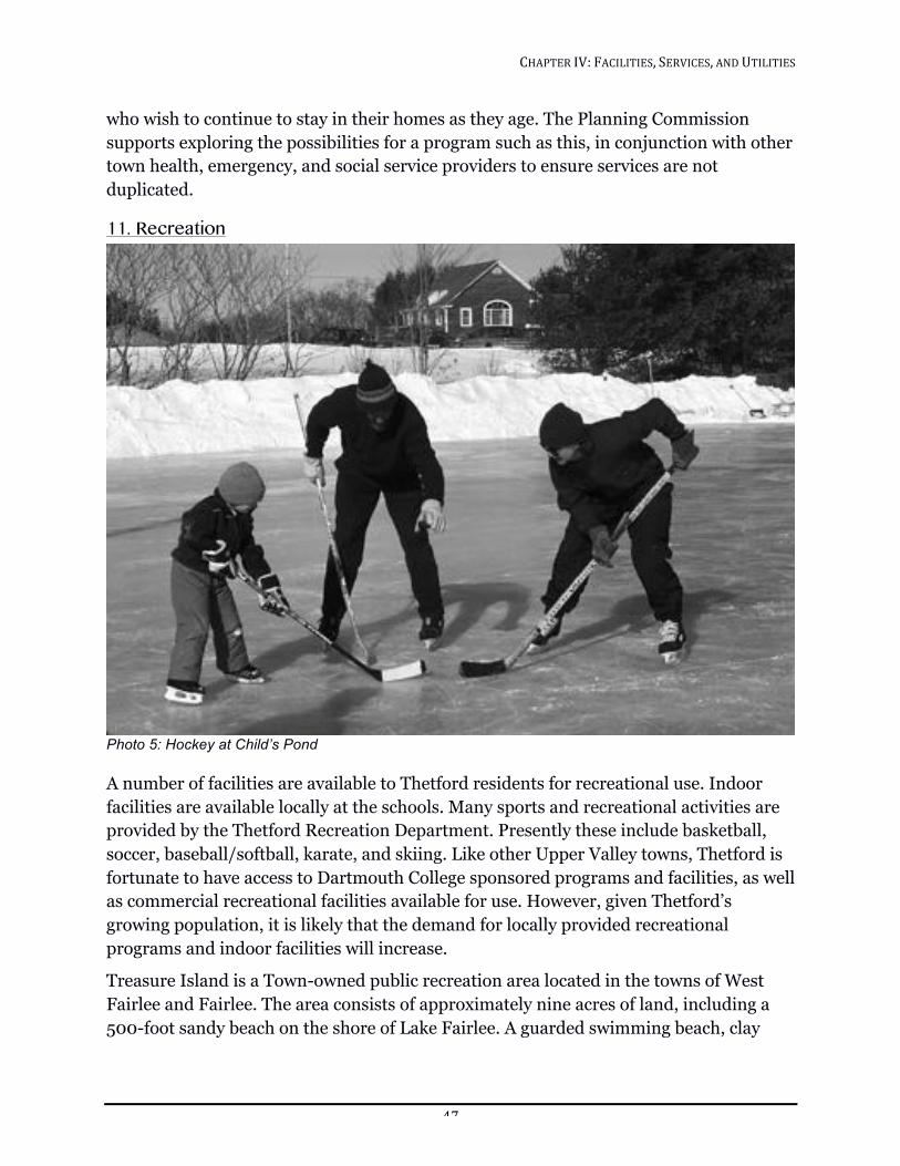
CHAPTER!IV:!FACILITIES,!SERVICES,!AND!UTILITIES!!
47!
who wish to continue to stay in their homes as they age. The Planning Commission supports exploring the possibilities for a program such as this, in conjunction with other town health, emergency, and social service providers to ensure services are not duplicated.
11. Recreation
!Photo 5: Hockey at Child’s Pond!
A number of facilities are available to Thetford residents for recreational use. Indoor facilities are available locally at the schools. Many sports and recreational activities are provided by the Thetford Recreation Department. Presently these include basketball, soccer, baseball/softball, karate, and skiing. Like other Upper Valley towns, Thetford is fortunate to have access to Dartmouth College sponsored programs and facilities, as well as commercial recreational facilities available for use. However, given Thetford’s growing population, it is likely that the demand for locally provided recreational programs and indoor facilities will increase.
Treasure Island is a Town-owned public recreation area located in the towns of West Fairlee and Fairlee. The area consists of approximately nine acres of land, including a 500-foot sandy beach on the shore of Lake Fairlee. A guarded swimming beach, clay
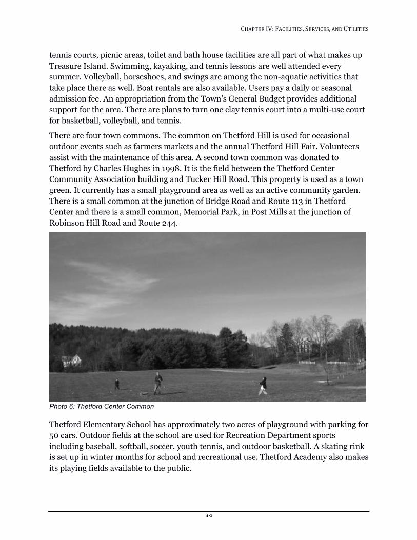
CHAPTER!IV:!FACILITIES,!SERVICES,!AND!UTILITIES!!
48!
tennis courts, picnic areas, toilet and bath house facilities are all part of what makes up Treasure Island. Swimming, kayaking, and tennis lessons are well attended every summer. Volleyball, horseshoes, and swings are among the non-aquatic activities that take place there as well. Boat rentals are also available. Users pay a daily or seasonal admission fee. An appropriation from the Town’s General Budget provides additional support for the area. There are plans to turn one clay tennis court into a multi-use court for basketball, volleyball, and tennis.
There are four town commons. The common on Thetford Hill is used for occasional outdoor events such as farmers markets and the annual Thetford Hill Fair. Volunteers assist with the maintenance of this area. A second town common was donated to Thetford by Charles Hughes in 1998. It is the field between the Thetford Center Community Association building and Tucker Hill Road. This property is used as a town green. It currently has a small playground area as well as an active community garden. There is a small common at the junction of Bridge Road and Route 113 in Thetford Center and there is a small common, Memorial Park, in Post Mills at the junction of Robinson Hill Road and Route 244.
!Photo 6: Thetford Center Common!
Thetford Elementary School has approximately two acres of playground with parking for 50 cars. Outdoor fields at the school are used for Recreation Department sports including baseball, softball, soccer, youth tennis, and outdoor basketball. A skating rink is set up in winter months for school and recreational use. Thetford Academy also makes its playing fields available to the public.
CHAPTER!IV:!FACILITIES,!SERVICES,!AND!UTILITIES!!
49!
There is also a Little League field used and maintained by the Recreation Department, located in Post Mills and owned by the Thetford Volunteer Fire Department.
The Thetford Recreation Department is a member of the Upper Valley Recreation Association. This association helps coordinate programs, camps, and the scheduling of games. Thetford is also a member of the Vermont Recreation and Parks Association and the New England Recreation and Parks Association.
The Thetford Snowcoasters maintains a network of over 80 miles of snowmobile trails within the town. These trails join others in Strafford, West Fairlee, Fairlee, Norwich, and beyond.
The 229-acre Thetford Hill State Park, with access from Academy Road, has a 33-acre picnic area with 14 tables and grills and 40 parking spaces. Additionally, The Thetford Academy cross-country trail runs through the park.
The Thetford Hill State Forest, adjacent to Houghton Hill Road, is a 262-acre undeveloped tract with trails for hiking, cross-country skiing, and snowmobiling.
A fishing access point maintained by the Vermont State Department of Fish and Wildlife is located on the Connecticut River in North Thetford. It is open to the public without charge.
The US Army Corps of Engineers oversees the Union Village Dam, a flood control project along the East and West Branches of the Ompompanoosuc River, which includes 991 acres of land. Fishing, swimming, hunting, picnicking, hiking, and cross-country skiing take place at this area. It is open to the public at no charge and there are three picnic areas with tables, rest rooms, and drinking water.
Through the years the town has received land from several sources. A Thetford Town Forest is located off Five Corners Road, near Thetford Center. This 176-acre tract of woodland is leased to the Upper Valley Fish and Game Club, Inc. The Club has cleared a section of land near the road and has set up ranges for rifle, pistol, archery, and trap shooting. Local State Police and County Sheriffs’ departments use the range as well. The club also sponsors Hunter Safety courses twice a year. Children’s fishing derbies are held at the man-made pond to the north of the range. The Upper Valley Fish and Game Club has logged small areas periodically to create spaces for varied wildlife habitat.
The Post Mills Natural Area was created from 104 acres donated to the Town by the state as part of a settlement that provided for capping an adjacent landfill and provision for a watershed and wellhead protection area for neighboring residences. The land is managed for wildlife with an emphasis on keeping the fields open and allowing the forest to mature. Non-motorized recreation such as walking, birding, and skiing are permitted. Parking is available on a right-of-way to the area. A management plan has
CHAPTER!IV:!FACILITIES,!SERVICES,!AND!UTILITIES!!
50!
been approved for this property by the Selectboard and the Upper Valley Land Trust and is available at the Town Hall or through the Thetford Conservation Commission.
The Hughes Forest is a 280-acre parcel owned by the town through a donation by the Vermont Nature Conservancy. The property can be accessed from Sawnee Bean Road, Poor Farm Road, or Whippoorwill Road. There is a small parking area on Sawnee Bean Road with a walking trail near the pond. The parcel is managed as a woodlot with an equal emphasis on wildlife. In 2008 the Town adopted a forestry management plan that documents the result of the forestry inventory and lays out a plan for improving timber quality.
In late 2005, a 21-acre Class 2 wetland known informally as ‘the DeCola wetland’ located on Godfrey Road was donated to the Town. The Thetford Conservation Commission inventoried the wetland for significant wildlife and plants in 2009 and 2015. The property will be used for educational purposes illustrating the critical role wetlands play in providing habitat for many animals and plants, protecting land from flooding, stabilizing soil, improving water quality by storing organic matter, removing pollutants, and by filtering eroded sediments from surface runoff.
The Zebedee wetland, located off Houghton Hill Road, is another parcel available for outdoor exploration and education. This rich piece of land is a 27-acre parcel that has been conserved through the Upper Valley Land Trust.
The Taylor recreational fields consist of 36 acres of wooded, open and wetland area adjacent to the Ompompanoosuc River in Post Mills. In July 2013 this property was officially protected with a conservation easement held by the Upper Valley Land Trust. This nature preserve is owned by the Town of Thetford and is open to the public.
TOWN AND COMMUNITY UTILITIES Cell phone service and high-speed Internet access have become a necessity in our lives, just as electricity and the telephone were in the early part of the last century. These modern technologies utilize towers, antennas, and additional wire strung along poles or run underground. Federal statutes mandate that these services be made available to everyone, thereby limiting the rights of towns to review and condition these projects. In some cases local review is eliminated entirely.
Due to hilly terrain and the limited number of towers, cell service in Thetford is spotty and nonexistent in some areas. Thetford’s Telecommunication Bylaw permits towers in any district while minimizing their adverse visual impact on public areas without limiting service. Cell service, which often also delivers Internet access, and broadband Internet access are utilities which help provide important benefits to residents including safety and security, education, economic, health monitoring, entertainment, etc. The Town should continue to support these services while minimizing the adverse visual
CHAPTER!IV:!FACILITIES,!SERVICES,!AND!UTILITIES!!
51!
impact of towers, antennas, and wires to the extent possible. Although parts of town have access to broadband Internet service over cable, DSL, digital subscriber line, or through wireless providers, many areas cannot obtain high-speed Internet connections. These areas of town are limited to slow dial-up or less slow but expensive satellite services. A “Fiber to the Home” network, which proposes to provide service to the entire town at speeds substantially faster than either cable or DSL, has some infrastructure in place at the time of this writing.
Provision of broadband services to all areas of town is an important ingredient in attracting new residents and businesses as well as maintaining a vibrant community.
GOALS, POLICIES, AND RECOMMENDATIONS Thetford is committed to supporting the continued vitality of the community by maintaining and upgrading shared facilities, services, and utilities, balanced by careful consideration of town needs and taxpayer resources.
Town and Community Facilities Goal
Maintain Town-owned facilities and upgrade energy performance, where practical, to maintain property values and reduce operating expenses. Please refer to the Energy chapter of this plan for more details on energy performance upgrading.
Policies
1. Maintain a proactive approach to identifying any maintenance and repair issues with Town-owned facilities.
2. Find new uses for the older community facilities that are underutilized and that might serve new or multiple purposes.
3. Promote the buildings identified as public gathering places to be used for community activities or private events, as long as the appearance is not altered significantly.
Recommendations
1. The Town should make an inventory of existing facilities and prioritize a schedule for maintenance and repair.
2. The Town should continue the search for a new property to house and garage the Public Works Department.
3. The Town should continue the search for a new property for the Recycling Center and extend the hours of operation.
CHAPTER!IV:!FACILITIES,!SERVICES,!AND!UTILITIES!!
52!
LIBRARIES
Goals
1. Continue to support the Library Federation and the individual libraries and foster cooperation between the libraries in town, while preventing unnecessary duplication of services and encouraging efficient use of town resources.
2. Increase access to technology and digital literacy for patrons, staff, and volunteers.14 (From Latham Memorial Library’s Strategic Plan 2013-2015.)
Policies
1. Support a Town Librarian who spends part-time in each of the Library Federation libraries.
2. Reconfigure current and future space to increase and improve library services at Latham Memorial Library. (From Latham Memorial Library’s Strategic plan 2013 – 2015.)
3. Attract diverse groups to the library through improved communications and programs. (From Latham Memorial Library’s Strategic plan 2013 – 2015.)
Recommendation
The Town should support current technology and resources across the Thetford Libraries.
CEMETERIES
Goal
Ensure adequate space for future burials.
Policy
Maintain the existing cemeteries.
Recommendations
1. The Cemetery Commission should develop a plan for the long-term maintenance and upkeep of the existing cemeteries.
2. The Town should consider expansion of cemetery space as needed, through acquisition of new property or designating existing Town-owned property.
3. The Town should budget for comprehensive maintenance including headstone repair and replacement and additional drainage as needed.
14 Latham Memorial Library’s Strategic Plan 2013-2015. Available at Latham Library.
CHAPTER!IV:!FACILITIES,!SERVICES,!AND!UTILITIES!!
53!
4. The Town should allocate additional funds to the Town capital reserves to support the Cemetery Commission’s long term plan.
Town and Community Services and Utilities
WATER
Goal
Continue to protect and preserve the quality and quantity of water resources in the town. (For more on this please see the Natural Resources chapter.)
Policy
Prevent contamination of Thetford’s water resources by such things as road salt, erosion, agricultural runoff, and failed septic systems.
SOLID WASTE AND SEPTAGE
Goal
Continue to support efforts to recycle and programs that encourage reuse and recycling.
Policy
Support regional solutions for solid waste and septage, in cooperation with neighboring towns in Vermont and New Hampshire.
Recommendations
1. The Town should study ways to expand participation in recycling, including workshops for elementary and high school students.
2. The Town should maintain participation in the Greater Upper Valley Solid Waste Management District.
3. The Town should monitor effects of Vermont Act 148 on waste disposal and small local businesses.
POLICE PROTECTION
Goal
Maintain enough of a police presence to result in an acceptable level of public safety.
Policy
Support the needs of the Police Department without adding undue financial burden to the community.
Recommendation
The Town should continue to look for additional space for the changing needs of the Police Department.
CHAPTER!IV:!FACILITIES,!SERVICES,!AND!UTILITIES!!
54!
FIRE AND EMERGENCY SERVICES
Goals
1. Maintain a well-trained and well-equipped volunteer fire department and emergency services department.
2. Ensure fire safety in homes and businesses.
Policies
1. Require new homes to provide year round access for emergency services equipment.
2. Require the Development Review Board to address water supply issues in all major developments that come before it.
3. Support the Thetford Fire Department’s expressed desire for a pressure system in East Thetford.
4. Ensure that driveway standards in zoning or Town ordinances comply with emergency services recommendations.
Recommendations
1. The Town should encourage home and business owners and community facilities to make use of early detection systems.
2. The Town should encourage home and business owners to consider use of sprinklers.
3. The Town should work in coordination with area health, emergency, and social service providers to choose and support the most effective means to expand the community’s ability to care for the health and well-being of people in Thetford.
RECREATION
Goal
Support recreation opportunities for all ages in Thetford.
Policy
Promote cooperation between the Town and schools in the use of current facilities and in the development of new facilities.
Recommendations
1. The Recreation Department should undertake an in-depth study of recreation needs to plan for the future.
2. The Town should investigate purchasing state or federal lands when any come up for sale in Thetford.
CHAPTER!IV:!FACILITIES,!SERVICES,!AND!UTILITIES!!
55!
3. The Town should expand and maintain the network of trails to connect each park and town, state, and federal open space areas in a manner consistent with and sensitive to the Town Plan.
4. The Town should initiate a reserve capital improvement account for development of new recreational facilities and programs.
5. The Town should explore the feasibility of a Connecticut River recreation area for water activities and picnicking.
6. The Town should encourage the schools to make their facilities available to the community at large.
7. The Town should identify new playground and park areas for each village.
TELECOMMUNICATIONS
Goal
Support public and private efforts to bring high-speed Internet services to all areas of Thetford.
Recommendation
The Town should continue to explore expanding high-speed Internet to the secondary and tertiary roads.
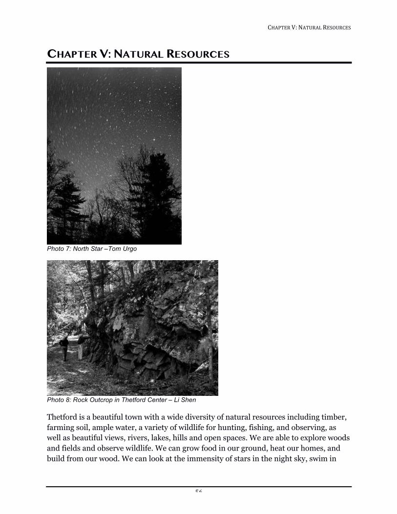
CHAPTER!V:!NATURAL!RESOURCES!!
56!
CHAPTER V: NATURAL RESOURCES
!Photo 7: North Star –Tom Urgo
!Photo 8: Rock Outcrop in Thetford Center – Li Shen
Thetford is a beautiful town with a wide diversity of natural resources including timber, farming soil, ample water, a variety of wildlife for hunting, fishing, and observing, as well as beautiful views, rivers, lakes, hills and open spaces. We are able to explore woods and fields and observe wildlife. We can grow food in our ground, heat our homes, and build from our wood. We can look at the immensity of stars in the night sky, swim in
CHAPTER!V:!NATURAL!RESOURCES!!
57!
cold, clear water, or rumple the mud under our feet. This connection with the natural world is one of the enormous benefits we enjoy by living in Thetford. Recognizing that it is our privilege to live here, we want to move beyond using and enjoying our town to preserving and improving our natural resources for the residents of Thetford five, ten, and one hundred years from now.
To know what steps to take to reach this goal, we begin by reviewing the variety of natural resources available in Thetford, and how our choices affect the future of those resources.
Thetford’s landscape consists of fertile valley bottoms separated by forested ridgelines, slopes, and terraces, deeply furrowed by the channels of streams. The largest river in New England, the Connecticut, forms the eastern border of our town and one of New England’s most beautiful rivers, the Ompompanoosuc, flows through Thetford in two branches which meet in the Union Village Dam Recreation Area and empty into the Connecticut River.
WATER In 1997, a town-wide visioning process in Thetford listed water quality as the most important issue to address.15 The 1986 Vermont Legislature amended Vermont’s water quality statutes to say, "it is the policy of the state to seek over the long term to upgrade the quality of waters and to reduce existing risks to water quality.”16 To achieve this goal, the state requires all river watersheds to have a “basin plan” under §303(e) of the federal Clean Water Act (33 U.S.C. §§1251-1387) and 40 C.F.R. part 131. The basin plan for the Ompompanoosuc was finalized in 2008 and is the basis for some of the recommendations in this chapter.
In order to protect channel and floodplain stability, wildlife habitats, and water quality, the Vermont Agency of Natural Resources and Accepted Agricultural Practices recommend maintaining buffers of native woody plants between developed land and waters and establishing setbacks between the edge of the water and structures. Current Zoning Bylaws include riparian and shoreline setbacks where no structures shall be allowed within the setback distances for streams and ponds.
15 Thetford Community Profile Report from November 1997 16 10 V.S.A. §1250: Water Pollution Control
CHAPTER!V:!NATURAL!RESOURCES!!
58!
Flowing Waters
THE CONNECTICUT RIVER
Thetford has approximately 8.5 miles of frontage on the Connecticut River, the largest and most powerful river in New England. In May 2012, the US Department of the Interior designated the Connecticut and its watershed as the nation’s first Blueway, which recognizes collaborative “source to sea” stewardship of resources. The watershed contains premier fish and wildlife habitat and the river is a major migration route for waterfowl. Otter, mink, bald eagles, and migrating osprey hunt the river. Millennia of flooding and sediment deposition in the floodplain have created some of the richest agricultural soils in the entire continent.
Large hydroelectric dams on the Connecticut were not built expressly for flood control and there is still danger of flooding on the river. Flooding causes costly damage either through inundation or when the river cuts away the surrounding land, a process called fluvial erosion.
In Thetford, the level of the Connecticut River is controlled by the Wilder Dam. The river is kept unnaturally high and wide and its level fluctuates with the daily opening and closing of the dam. Typical fluvial erosion is not as much of an issue as the erosion caused by frequent changes in water levels and the action of boat wakes. A study in the 1970s documented two sites of erosion in Thetford where the riverbank was receding by four and six feet per year. This loss of our best agricultural soils is ongoing. In February 2013, the Two Rivers-Ottauquechee Regional Planning Commission requested that a study of the effects of erosion be completed as part of the relicensing of the Wilder Dam.
Two studies by the EPA detected heavy metals and polycyclic aromatic hydrocarbons (PAH) from automobiles in Connecticut River sediments in the Upper Valley.17 Adequate riparian buffers can prevent pollution from washing into the river.
The Connecticut is a popular destination for swimming, boating, fishing, and riverside camping. Recreational access to the river is provided via the North Thetford Fish and Wildlife Department boat launch; Thetford may wish to consider ways to expand access in the future.
17 Water Resources by Ct River Joint Commission, updated July, 2009 pp. 85-85 http://www.crjc.org/waterresources.htm
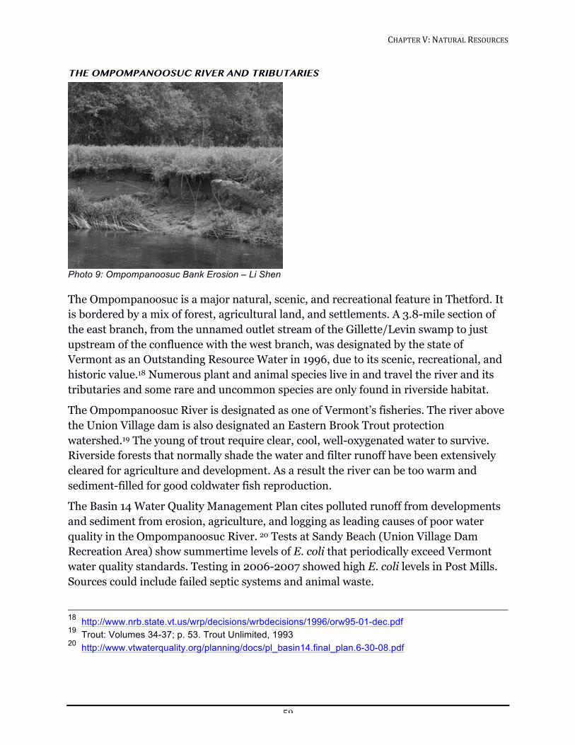
CHAPTER!V:!NATURAL!RESOURCES!!
59!
THE OMPOMPANOOSUC RIVER AND TRIBUTARIES
!Photo 9: Ompompanoosuc Bank Erosion – Li Shen
The Ompompanoosuc is a major natural, scenic, and recreational feature in Thetford. It is bordered by a mix of forest, agricultural land, and settlements. A 3.8-mile section of the east branch, from the unnamed outlet stream of the Gillette/Levin swamp to just upstream of the confluence with the west branch, was designated by the state of Vermont as an Outstanding Resource Water in 1996, due to its scenic, recreational, and historic value.18 Numerous plant and animal species live in and travel the river and its tributaries and some rare and uncommon species are only found in riverside habitat.
The Ompompanoosuc River is designated as one of Vermont’s fisheries. The river above the Union Village dam is also designated an Eastern Brook Trout protection watershed.19 The young of trout require clear, cool, well-oxygenated water to survive. Riverside forests that normally shade the water and filter runoff have been extensively cleared for agriculture and development. As a result the river can be too warm and sediment-filled for good coldwater fish reproduction.
The Basin 14 Water Quality Management Plan cites polluted runoff from developments and sediment from erosion, agriculture, and logging as leading causes of poor water quality in the Ompompanoosuc River. 20 Tests at Sandy Beach (Union Village Dam Recreation Area) show summertime levels of E. coli that periodically exceed Vermont water quality standards. Testing in 2006-2007 showed high E. coli levels in Post Mills. Sources could include failed septic systems and animal waste.
18 http://www.nrb.state.vt.us/wrp/decisions/wrbdecisions/1996/orw95-01-dec.pdf 19 Trout: Volumes 34-37; p. 53. Trout Unlimited, 1993 20 http://www.vtwaterquality.org/planning/docs/pl_basin14.final_plan.6-30-08.pdf
CHAPTER!V:!NATURAL!RESOURCES!!
60!
The 2009 Phase 1 Stream Geomorphic Assessment of the Ompompanoosuc found that the river suffers from much artificial straightening and berming, primarily to accommodate roads next to the river.21 Channel straightening makes the river flow more swiftly, eroding and destabilizing its banks. Riverside roads can be expensive to maintain as rivers try to regain their natural course. It is important to protect undeveloped river sections to allow the space for channel adjustment; otherwise, management of the river will become increasingly difficult and expensive.
Undersized or improperly installed bridges and culverts for both roads and driveways create problems. When squeezed through an undersized space, the water speeds up and erodes the downstream channel. Undersized culverts also fail in floods. “Hanging culverts” present insurmountable barriers to fish and other aquatic life.
The Ompompanoosuc and its tributaries are interrupted by several dams. The largest is the United States Army Corps of Engineers Union Village flood control dam that allows free flow during the summer. Other dams include the derelict Montague Rod and Reel Mill dam in Post Mills and the Lake Fairlee Outlet dam. Dams disrupt the river’s transport of sediment by trapping sediment on their upstream side. The downstream river then lacks sufficient sediment to absorb its excess energy and it replenishes its sediment by eroding and widening the downstream channel. The 2011 Ompompanoosuc Phase 2 Geomorphic Assessment and River Corridor Plan for West Fairlee and upper Post Mills recommends that the Montague Rod and Reel Dam be removed.22
Still Waters
LAKES AND PONDS
Neither biologists, lawyers, or town planners have come up with a universally accepted distinction between a lake and a pond, though there is general agreement that it has something to do with size and depth, quantity of rooted plants, temperature difference in depth of water, wave height in storms, and size of the outlet or feeder stream. In Thetford, we have Lake Fairlee and Child’s Pond, which are both probably lakes, mid-sized ponds, including Lake Abenaki, and smaller ponds (under ten acres).
Child’s Pond is a kettle pond ten acres in size, with lake-like depth and temperature stratification. Lying less than 200 feet from Connecticut River, its surface is over 150 feet above that waterway, while the soil underlying the pond is composed of quicksand.
In addition to Lake Fairlee and Child’s Pond, Thetford has several mid-sized ponds including Lake Abenaki (sometimes called Mud Pond), Payson Pond (also called Lily
21 http://thetfordvermont.us/docs/ccminutes/Omp%20P1Report_Final@204_16_09.pdf 22 http://www.vtwaterquality.org/planning/htm/pl_stevens.htm
CHAPTER!V:!NATURAL!RESOURCES!!
61!
Pond), Norford Lake, Mud Pond, and Forsythe Pond (which is also known as Mud Pond on some maps). Thetford also has 128 ponds under ten acres in size. The main concerns regarding ponds include nutrient enrichment, exotic species, acidification and toxins, as well as dams and water level fluctuations. The Agency of Natural Resources Basin 14 Water Quality Management plan recommends protecting the shorelines of Lake Abenaki and Lake Fairlee through voluntary conservation of shoreline property. In the Thetford Zoning Bylaw adopted September 26, 2011, the town included a 75 feet shoreline setback for Lake Fairlee, Child’s Pond, Mud Pond, Lake Abenaki, Norford Lake, and the unnamed pond off Cream Street (Payson or Lily Pond).
Lake Fairlee straddles the town lines of Fairlee, Thetford, and West Fairlee. It covers about 460 acres and collects water from the surrounding 22 square miles. Middle Brook and Blood Brook are the primary inlets. The lake level is maintained by the outlet dam at the Thetford end of the lake.
The lake supports good vegetative and fish production, which brings many local and out-of-state fishermen to the state boat launch. Thetford’s ownership of Treasure Island and the popularity of watercraft like kayaks, paddleboards, and windsurfers reflect the importance of Lake Fairlee for recreation.
The lake has a rich ecosystem. There are perch, bass, and pickerel and the state Fish and Wildlife Department stocks the lake annually with brown trout and rainbow trout. An abundance of diverse wildlife species is attracted to the lake for its shoreland and freshwater habitat.
Threats to the lake can be identified by a review of the “Lake Score Card”, a tool developed by the state of Vermont to illustrate the health of a lake.23 Lake Fairlee received a red score, indicating worsening conditions or highly significant decline, in two areas: aquatic invasive species and shoreland/lake habitat. More than 50% of Lake Fairlee’s native shore vegetation has been replaced by lawns to the water’s edge. Lawn instead of woodland at the water’s edge destroys the shore and shallow water habitat. Highly developed shores are ranked by the US Environmental Protection Agency as the number one threat to a lake’s biology.24 Excessive nutrients coming from erosion and runoff in unbuffered sections of Middle Brook and Blood Brook threaten lake water quality. For instance, trampling by livestock on Blood Brook is aggravating bank erosion and the river is not protected from their manure.25
23 http://www.vtwaterquality.org/cfm/lakerep/lakerep_details.cfm?id=FAIRLEE
24 http://www.anr.state.vt.us/anr/envrptsb/ANREnvReport2011.pdf, p.14 25 http://www.vtwaterquality.org/planning/htm/pl_stevens.htm
CHAPTER!V:!NATURAL!RESOURCES!!
62!
A shoreline protection bill is pending in the Vermont state legislature as of January, 2014, which would require shoreline property owners to seek a permit from either the town or state to build something new over a certain size. The Thetford Zoning Administrator is working to ensure that property owners who may be affected are knowledgeable about the bill and have the opportunity to be engaged in the legislative process.
The lake is owned by the State of Vermont but the outlet dam is in private ownership. At the last state inspection in 2009 the following recommendation was made: “Due to the deteriorating condition of the cement, plans for repairs and/or replacement of the concrete should be implemented.” The integrity of the dam is a serious concern for the camps, property owners, and the community; if the dam were to fail, it could reduce the shoreline by 8 to 12 feet, resulting in a significant economic impact on all three towns that border the lake. In early 2012 a Tri-Town Committee was formed which can make recommendations for action to the selectboards involved: Fairlee, West Fairlee, and Thetford. At town meetings in March of 2013 each of the three towns approved funds to pay for the planning phase of the project. The engineering firm of Dubois & King completed a series of engineering studies and extensive study of possible solutions. By October, the Committee received a final report from Dubois & King, which involves rebuilding the dam in its present location. They are following through on the details of that work. The selectboards of the three towns are considering an interlocal agreement, a contract that would outline their cooperation in the ongoing operation and management of the dam.
WETLANDS
Wetlands are hotspots of biodiversity and among the most productive of all ecosystems. They are critical habitat for breeding and migratory waterfowl. Overall, about half of our rare and endangered species rely on them, some requiring connections between wetlands. The hydric soils of wetlands are dominated by communities of specially adapted plants.
Wetlands perform many essential functions for which they are protected by Vermont’s Wetland Rules.26 They temporarily store floodwaters and stormwater runoff, attenuate flood flows, and reduce property damage caused by inundation or erosion. Water flowing through wetlands is cleansed; sediment, organic matter, and nutrients such as phosphate are removed. Wetlands also recharge groundwater by holding water so it can percolate into the soil.
26 http://www.nrb.state.vt.us/wrp/rulemaking/wetlands2010/filedruledocs/VWR%207-16-10.pdf
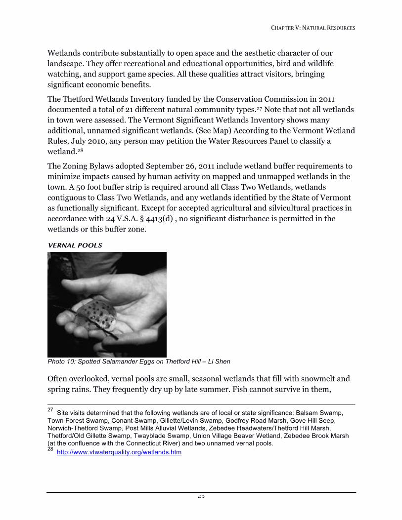
CHAPTER!V:!NATURAL!RESOURCES!!
63!
Wetlands contribute substantially to open space and the aesthetic character of our landscape. They offer recreational and educational opportunities, bird and wildlife watching, and support game species. All these qualities attract visitors, bringing significant economic benefits.
The Thetford Wetlands Inventory funded by the Conservation Commission in 2011 documented a total of 21 different natural community types.27 Note that not all wetlands in town were assessed. The Vermont Significant Wetlands Inventory shows many additional, unnamed significant wetlands. (See Map) According to the Vermont Wetland Rules, July 2010, any person may petition the Water Resources Panel to classify a wetland.28
The Zoning Bylaws adopted September 26, 2011 include wetland buffer requirements to minimize impacts caused by human activity on mapped and unmapped wetlands in the town. A 50 foot buffer strip is required around all Class Two Wetlands, wetlands contiguous to Class Two Wetlands, and any wetlands identified by the State of Vermont as functionally significant. Except for accepted agricultural and silvicultural practices in accordance with 24 V.S.A. § 4413(d) , no significant disturbance is permitted in the wetlands or this buffer zone.
VERNAL POOLS
!Photo 10: Spotted Salamander Eggs on Thetford Hill – Li Shen
Often overlooked, vernal pools are small, seasonal wetlands that fill with snowmelt and spring rains. They frequently dry up by late summer. Fish cannot survive in them,
27 Site visits determined that the following wetlands are of local or state significance: Balsam Swamp, Town Forest Swamp, Conant Swamp, Gillette/Levin Swamp, Godfrey Road Marsh, Gove Hill Seep, Norwich-Thetford Swamp, Post Mills Alluvial Wetlands, Zebedee Headwaters/Thetford Hill Marsh, Thetford/Old Gillette Swamp, Twayblade Swamp, Union Village Beaver Wetland, Zebedee Brook Marsh (at the confluence with the Connecticut River) and two unnamed vernal pools. 28 http://www.vtwaterquality.org/wetlands.htm
CHAPTER!V:!NATURAL!RESOURCES!!
64!
making them critical breeding habitats for wood frogs and salamanders, species of conservation concern. Not every wet depression is a vernal pool. A working definition of a vernal pool is one that contains evidence of two or more indicator species or over 20 egg masses of one of these species. These indicator species include wood frog, mole salamanders (spotted, blue-spotted, and Jefferson salamanders), and fairy shrimp. Despite their small size, (<0.1-2 acres, but generally smaller than .5 acre) vernal pools contribute a huge amount of food to animals of the surrounding upland in the form of water insects, frogs and salamanders, and their tadpoles.29 The Jefferson salamander has been designated a Species of Greatest Conservation Need (high priority) and the blue-spotted and spotted salamanders as Species of Greatest Conservation Need (medium priority) in Vermont’s Wildlife Action Plan. The critical terrestrial habitat of mole salamanders extends about 535 feet (175 meters) out from the high-water mark of a vernal pool.30 If the vernal pool were <0.1-2 acres and a perfect circle, this habitat area would be less than 23.6-35.5 acres. Because vernal pools aren’t perfect circles, the total habitat area will be somewhat larger. To protect these salamanders, it is essential to consider not only the pool itself but also the surrounding habitat area. Amphibians are very sensitive and pools are quickly made uninhabitable by such pollutants as road salt, pesticides, oil, or sediment. While we’re not going to move major roads because they’re within 500 ft. of a vernal pool, delineating the critical habitat is an attempt to understand the effects human actions are having and choose when we can eliminate, minimize or mitigate disturbance.
Because their movement on dry land is limited, amphibians need multiple pools or wetlands within short distances for dispersal and repopulation. Ruts, excess slash, debris piles, roads, and driveways are all barriers to movement. Roads are a direct and serious cause of mortality. A partial inventory of Thetford’s vernal pools was conducted in 2010. (See Map) We recommend that landowners consider the interdependency of plant and animal communities and leave as light a footprint as possible. Landowners are the best monitors of vernal pools, keeping track of the wildlife present, documenting findings, and following practices that help protect the health of the pool. Information and help identifying vernal pools is available through VINS (the Vermont Institute of Natural Sciences) and the Vermont NRCS (Natural Resources Conservation Service).
29 http://www.nrcs.usda.gov/Internet/FSE_DOCUMENTS/nrcs142p2_010203.pdf 30 Vermont Center for Ecostudies; Research Notes #3: Salamander strategies; Faccio, S. D. 2003. “Post-breeding emigration and habitat use of radio-implanted Jefferson and spotted salamanders in Vermont.” Journal of Herpetology 37:479-489.
CHAPTER!V:!NATURAL!RESOURCES!!
65!
GROUNDWATER AND AQUIFERS
While many communities in the US struggle with water issues, our area is blessed with an abundance of clean water. We should not take this valuable resource for granted.
Groundwater is the primary source of our drinking water. Most of us rely on individual wells or springs, except for those who take water from Lake Fairlee, Norford Lake, or ponds in town. There are a handful of official community water systems (those serving ten or more households or 25 people) that supply water to limited areas of town. Aquifer Protection Areas (APAs) have been delineated for these systems and are shown on the Natural Resources Map (2007 Maps). There are state rules for APAs that apply in these areas.31 Thetford currently has no specific rules regarding APAs. There are also smaller water sources that have multiple users.
Groundwater is often necessary for crop irrigation and livestock, and is a potential resource for many businesses, such as processing facilities that need clean water. Groundwater is threatened by spills of hazardous materials, improper treatment of septage, poor agricultural practices, road salt, and leaks from underground fuel tanks. Protection of groundwater from pollution or depletion is critical.
EARTH
Slope Slopes are a crucial part of Thetford’s topography. They determine how fast water flows downhill, how much soil moisture is retained, and how much solar radiation heats the ground. These factors influence productivity of the land for agriculture, forestry, and wildlife. Slope aspect is important, affecting solar radiation, productivity, and the freeze-thaw cycle.
Thetford’s topography can be expressed in five slope percentage categories, A: 0-3% (Flat); B: 4-8% (Rolling); C: 9-14% (Moderately Steep); D: 15-25% (Steep); and E: greater than 25% (Very Steep). (See 2007 Map) “Very Steep” slopes should remain completely undisturbed; “Steep” slopes may be developed only if no viable alternative exists.
On “Steep” slopes soil erosion is of great concern. Exposing the lower layers, or substrata of soils can irreversibly harm their structural integrity. When disturbed, many slopes will immediately erode, compromising their strength for supporting roadways or foundations. Flow of water down the slope becomes uneven, creating flood areas and dead, dry zones. The exposure of lower soil layers that lack microbes means that 90% of nutrient cycling is lost. The plants normally found in steep, wooded areas in Vermont do 31 VT Statutes Title 10: Chapter 56
CHAPTER!V:!NATURAL!RESOURCES!!
66!
not do well in the sterile soils exposed by hillside erosion. Those that fill in this vacuum are more likely to be non-native invasives, some of which were originally imported to help control erosion.
Destabilized slopes rapidly transport sediments downhill. Silt can remain suspended in runoff for over 400 ft. and pollute streams and surface water, damaging aquatic life. Development on steep slopes is likely to cause environmental problems and providing emergency services to places with steep access is problematic (e.g., in winter).
Agricultural and Silvicultural Soils Thetford possesses geological deposits of outstanding soils for agriculture that are recognized for their prime or statewide importance. “Prime” farmland has the soil quality, growing season, and moisture supply needed to economically produce sustained high yields of crops under accepted farming methods. Prime soils are porous to water and air, contain few if any rocks, and are not flooded frequently. They are also available for agricultural use and may be cropland, pasture, or forestland, but not currently developed. As of 2013, Thetford has 2500 acres of designated Prime soil.
Soils and farmlands designated as “Important” statewide are less productive than Prime soils due to one or more of the following conditions: excessive slope, erosion hazard, excessive wetness or slow permeability, flooding hazard, depth less than 20 inches or moderately low to very low available water capacity. Thetford has 3,900 acres designated as being of Statewide Agricultural Importance. Areas of Prime and Important soils in Thetford are identified on the accompanying Soils Map.
These soils help farming be profitable and are not replaceable; they cannot be created. The main loss of these soils is by conversion from farmland to building lots for homes or businesses. The gentle slopes and deep soils that make land good for farming also make it easy to develop. Although Thetford generally has been active in conserving land for wildlife protection, soils of agricultural significance are virtually unprotected. While farmers should and do retain the right to development, this should be balanced against the preservation of a vital and irreplaceable resource. The Town should directly help landowners with the conservation of irreplaceable soils in any way possible. When the Town is crafting regulation that will affect agricultural soils, we need to include farmers and affected landowners in that discussion.
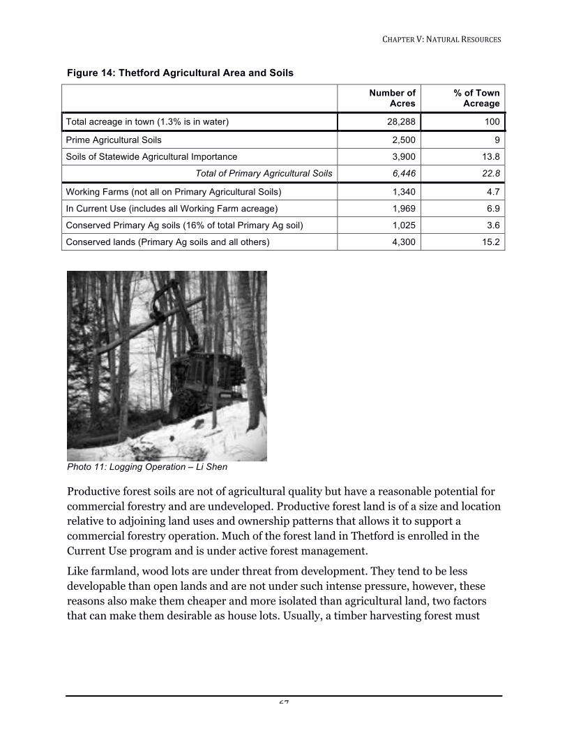
CHAPTER!V:!NATURAL!RESOURCES!!
67!
Figure 14: Thetford Agricultural Area and Soils
Number of Acres
% of Town Acreage
Total acreage in town (1.3% is in water) 28,288 100
Prime Agricultural Soils 2,500 9
Soils of Statewide Agricultural Importance 3,900 13.8
Total of Primary Agricultural Soils 6,446 22.8
Working Farms (not all on Primary Agricultural Soils) 1,340 4.7
In Current Use (includes all Working Farm acreage) 1,969 6.9
Conserved Primary Ag soils (16% of total Primary Ag soil) 1,025 3.6
Conserved lands (Primary Ag soils and all others) 4,300 15.2
!Photo 11: Logging Operation – Li Shen
Productive forest soils are not of agricultural quality but have a reasonable potential for commercial forestry and are undeveloped. Productive forest land is of a size and location relative to adjoining land uses and ownership patterns that allows it to support a commercial forestry operation. Much of the forest land in Thetford is enrolled in the Current Use program and is under active forest management.
Like farmland, wood lots are under threat from development. They tend to be less developable than open lands and are not under such intense pressure, however, these reasons also make them cheaper and more isolated than agricultural land, two factors that can make them desirable as house lots. Usually, a timber harvesting forest must
CHAPTER!V:!NATURAL!RESOURCES!!
68!
cover at least 50 acres to be considered economically viable.32 If large tracts of forest are kept intact, Thetford will reap their benefits for a long time to come.
Landscape Features Enduring features include topographic elements (mountains, hills, valleys) and landscape features such as bedrock and surficial deposits (e.g., sand, gravel, silt, clay, peat). The greatest variety of the latter occurs in low-lying areas where melting glaciers made surficial deposits. Cliffs, talus, steep slopes, and caves are other examples of enduring features.
Enduring features may be home to specific species and plant communities. Ledges, cliffs, and other outcrops provide den or nest sites for such species as bobcat, bats, eagles, falcons, and ravens. Rocky crevices, caves, boulder piles, and talus slopes provide shelter for rare small-footed and other bats, snakes, and many mammals. Gravel pits and sandy bare areas favor nesting by turtles, including the wood turtle, and uncommon, declining birds such as nighthawks, larks, and vesper sparrow. Other species create burrows in muddy banks (muskrats, otters) and sandy banks (kingfisher, bank swallow). Protecting a variety of enduring features preserves the town’s biodiversity of plants and animals.
FLORA & FAUNA
Forests Forests are the major vegetative cover in Thetford and give the landscape its essence and character. Forests provide many “capital services”. They prevent erosion and protect water quality. They filter groundwater, cleanse the air by photosynthesis, and prevent floods by absorbing rainwater. Transpiration of water vapor from their leaves cools the surroundings and creates humidity. These services contribute to the comfort and stability of our climate. In contrast to costly, man-made, single-service facilities, healthy forests provide many services simultaneously, at no cost to the town.
Timber and wood products provide a livelihood for many residents. Firewood, pulp wood, sawlogs, woodchips, maple syrup, and Christmas trees are all potential products from our woods, as is biomass energy in the form of wood pellets.33 Forests also provide many community benefits such as scenic beauty, tourism income, hunting, trapping, hiking, bird watching, photography, nature observation, and quiet contemplation.
32 TRORC Regional Forest Stewardship Report 2012 33 Chuck Wooster article, Valley News, 7/15/2012. http://www.vitalcommunities.org/blog/wp-content/uploads/2012/10/Upper-Valley-Can-Heat-Itself-Wooster-VNews-7.15.12.pdf
CHAPTER!V:!NATURAL!RESOURCES!!
69!
Thetford, like all of Vermont, lies in a region known as transition forest, the zone between the coniferous boreal forest and the deciduous woodlands of temperate North America. Here over 100 species of woody plants are testing the limits of their northern or southern ranges. Transition forest has a longer growing season and is more open than boreal forest. This encourages wildflowers and understory growth and makes the forest more accessible.
Transition forests are extremely productive ecosystems that support the vast majority of the region’s wildlife species, from signature mammals like moose, bear, and bobcat to songbirds, salamanders, rodents, and insects. Groups of mature oak and beech trees (mast stands) are a key wildlife food source.
Population growth is bringing an increase in forest “parcelization”, whereby relatively large tracts are divided into smaller parcels. This leads to disjointed land ownership patterns and brings in housing and infrastructure such as clearings, driveways, roads, septic, and utility lines. Parcelization fragments the forest and negatively affects plants and animals, wildlife habitat, and water quality. It also reduces the ability of forestland to contribute to Vermont’s rural economy.
Uninterrupted forests provide interior forest habitats (core forest, 330 ft. from edges) required by reclusive wildlife species. The reduction of core forest by fragmentation renders forests unsuitable for many native plants and animals.
Wildlife Thetford has a diversity of wildlife, with species overlapping at the northern or southern extents of their range. Moose are close to the southern limit of their range, while white-tailed deer are at their northern limit. Both northern and southern flying squirrels are found here as well as hermit thrush (a northern species) and wood thrush (a southern species). In fact the transition forests of the northeast harbor the greatest diversity of songbirds in the US.
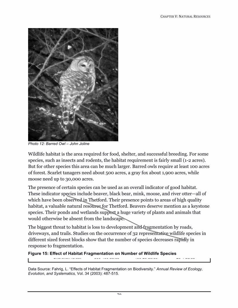
CHAPTER!V:!NATURAL!RESOURCES!!
70!
!Photo 12: Barred Owl – John Joline
Wildlife habitat is the area required for food, shelter, and successful breeding. For some species, such as insects and rodents, the habitat requirement is fairly small (1-2 acres). But for other species this area can be much larger. Barred owls require at least 100 acres of forest. Scarlet tanagers need about 500 acres, a gray fox about 1,900 acres, while moose need up to 30,000 acres.
The presence of certain species can be used as an overall indicator of good habitat. These indicator species include beaver, black bear, mink, moose, and river otter—all of which have been observed in Thetford. Their presence points to areas of high quality habitat, a valuable natural resource for Thetford. Beavers deserve mention as a keystone species. Their ponds and wetlands support a huge variety of plants and animals that would otherwise be absent from the landscape.
The biggest threat to habitat is loss to development and fragmentation by roads, driveways, and trails. Studies on the occurrence of 32 representative wildlife species in different sized forest blocks show that the number of species decreases rapidly in response to fragmentation. Figure 15: Effect of Habitat Fragmentation on Number of Wildlife Species
Data Source: Fahrig, L. “Effects of Habitat Fragmentation on Biodiversity.” Annual Review of Ecology, Evolution, and Systematics, Vol. 34 (2003): 487-515.
0
5
10
15
20
25
30
35
Unbroken forest 500-100 acres 100-20 acres 20-1 acres
Num
ber!of!W
ildlife!Species!
CHAPTER!V:!NATURAL!RESOURCES!!
71!
Not all species thrive in forest habitat. Exceptions include grassland birds and shrubland birds. Grassland birds are a priority for conservation in Vermont.34 For survival and reproduction, they need lands dominated by grasses, sedges, and forbs. Mowing prior to mid-July destroys their nests and young. Except for haying, cutting of grass fields should be delayed until the end of July or later.
Shrubland birds are songbirds and game birds (grouse, woodcock) that depend upon areas of low, thick woody growth. Many shrubland bird populations are declining. Most species prefer large (> 2.5 acre), blocks of shrub or early succession habitat.
Species that rely on riparian habitat have been greatly reduced throughout Vermont by riverside development. The state Wildlife Action Plan35 lists protection and restoration of riparian areas as highest priority activities. Uncommon riparian species include the wood turtle (Glyptemys insculpta) that overwinters in the Ompompanoosuc River and needs floodplain habitat and sandy areas to lay eggs. The wood turtle is declining everywhere. Habitat loss, mowing, and motor vehicles are the chief causes.
The use of motorized off-road vehicles (ORVs), including all terrain vehicles (ATVs) and snowmobiles, is an issue where there is strong disagreement in our town. Concerns include physical damage to trails and streambeds; effects on wildlife through habitat fragmentation, noise, and pollutants; the spread of invasive plants; and erosion, with its effects on water quality and fish. These vehicles can reach remote areas, disturbing interior forest habitats.
On the other hand, ORVs make it possible for people who are unable to walk great distances to get away from developed areas and enjoy the natural resources of Thetford. The use of ORVs need not create erosion or water pollution when they are driven with care for the land. Most users care about the land they drive on and are good stewards of that land. And it must be noted that non-motorized trail use, including mountain bikes, can cause similar damage, while unleashed or uncontrolled pets can also disturb wildlife and damage trails.
The Town has chosen not to allow roaming of dogs or other pet animals in Thetford. Off the owner’s property, animals must be leashed, in a vehicle, or reliably under command, hunting, working, or training with the owner. Thetford has also passed an ordinance controlling ATV use on town roads, while Vermont state law states that ATVs may be
34 Henslow’s Sparrow, Sedge Wren (both endangered), Upland Sandpiper, Grasshopper Sparrow (both threatened), Vesper Sparrow (uncommon), and Savannah Sparrow, Bobolink and Eastern Meadowlark (declining.) 35 http://www.vtfishandwildlife.com/swg_cwcs_report.cfm
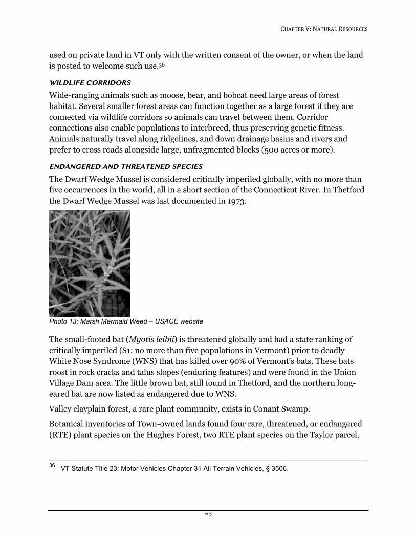
CHAPTER!V:!NATURAL!RESOURCES!!
72!
used on private land in VT only with the written consent of the owner, or when the land is posted to welcome such use.36
WILDLIFE CORRIDORS
Wide-ranging animals such as moose, bear, and bobcat need large areas of forest habitat. Several smaller forest areas can function together as a large forest if they are connected via wildlife corridors so animals can travel between them. Corridor connections also enable populations to interbreed, thus preserving genetic fitness. Animals naturally travel along ridgelines, and down drainage basins and rivers and prefer to cross roads alongside large, unfragmented blocks (500 acres or more).
ENDANGERED AND THREATENED SPECIES
The Dwarf Wedge Mussel is considered critically imperiled globally, with no more than five occurrences in the world, all in a short section of the Connecticut River. In Thetford the Dwarf Wedge Mussel was last documented in 1973.
!Photo 13: Marsh Mermaid Weed – USACE website
The small-footed bat (Myotis leibii) is threatened globally and had a state ranking of critically imperiled (S1: no more than five populations in Vermont) prior to deadly White Nose Syndrome (WNS) that has killed over 90% of Vermont’s bats. These bats roost in rock cracks and talus slopes (enduring features) and were found in the Union Village Dam area. The little brown bat, still found in Thetford, and the northern long-eared bat are now listed as endangered due to WNS.
Valley clayplain forest, a rare plant community, exists in Conant Swamp.
Botanical inventories of Town-owned lands found four rare, threatened, or endangered (RTE) plant species on the Hughes Forest, two RTE plant species on the Taylor parcel,
36 VT Statute Title 23: Motor Vehicles Chapter 31 All Terrain Vehicles, § 3506.
CHAPTER!V:!NATURAL!RESOURCES!!
73!
and four RTE plant species on the Town Forest. Large marsh-bedstraw and the marsh mermaid-weed, both ranked S1 (critically imperiled in Vermont), also occur in Thetford.
The fact that rare Vermont species were found by surveys of relatively small areas makes it highly likely that there are many more undocumented occurrences of rare, threatened, and endangered species in town.
CONCLUSION Thetford is fortunate to have a depth and variety of natural resources. The choices we make now will affect the future vitality of our town. Through informed actions and regulations enlightened by public input we can improve and preserve this wealth of natural resources. Our progress is ultimately guided by the people of the town.
GOALS, POLICIES AND RECOMMENDATIONS
All Natural Resources Goal
Conserve and improve Thetford’s natural resources so they are healthier in one hundred years than they are today.
Policy
The Selectboard and Department of Public Works direct activities related to road construction, improvement, and maintenance in a manner that protects and preserves natural resources.
Recommendations
1. The Town should give priority to the completion of inventories of natural resources, natural communities, and uncommon and rare species.
2. The Town should direct Town boards and encourage landowners to consult with the Conservation Commission when a decision is being made that might significantly affect an important natural resource and there are no clear existing guidelines.
3. The Town should recognize a natural area for each of Thetford’s villages, with input from the Conservation Commission if requested. If necessary, the Town could consider purchasing said areas.
4. The Town should continue to build the Conservation Trust Fund and conserve lands identified as important for permanent conservation in collaboration with landowners.
5. The Town should commit financial resources to conservation initiatives such as those recommended in this Plan.
CHAPTER!V:!NATURAL!RESOURCES!!
74!
Water
ALL WATERS
Goal
Protect and improve the quality of Thetford’s water resources and their natural environments.
Policies
1. Prevent pollution of all water resources.
2. Reduce flooding damage.
3. Reduce runoff of road sediment.
4. Leave natural buffers in place and restore buffers that have been destroyed.
Recommendations
1. The Town should continue to support shoreline setbacks (including all types of waters).
2. The Town should research effective riparian water protection and consider adopting incentives for creating shoreline buffers.
3. The Town should direct that failed septic systems that are not being repaired must be brought to the attention of the Town Health Officer, who will help evaluate the problem. Problems needing further resolution are dealt with by the Vermont Agency of Natural Resources Regional Office in Barre.
4. The Town should provide public education on septic system maintenance and cleanup of pet waste.
5. The Town should educate developers to retain storm water on site, reduce impervious land cover, and protect water quality.
6. The Town should educate townspeople and officials about Accepted Agricultural Practices37, pasture and barnyard management, shoreland and riparian buffers, and other topics relating to water quality.
7. The Town should pay extra vigilance to roads that border waters.
8. The Town should keep the Town road crew up-to-date using training from the Better Backroads Program38 on Best Practices for road repair, drainage, grading, salting, cleaning and other road maintenance.
37 http://www.vermontagriculture.com/ARMES/awq/AAP.html
CHAPTER!V:!NATURAL!RESOURCES!!
75!
9. The Town should publicize regional hazardous waste pickup for proper disposal of hazardous materials such as oil, paint, solvents, and pharmaceuticals at the Recycling Center.
10. The Town should conserve natural flood storage areas: floodplains, wetlands, etc.
11. The Selectboard and Planning Commission should create incentives for developers to plant vegetative buffers and preserve hydrologic connectivity of wetlands.
12. The Town should encourage porous surfaces to protect recharge of groundwater and reduce runoff of pollutants such as phosphorous.
13. The Town should adopt zoning bylaws incorporating standards for use of silt barriers between excavation and surface waters.
14. The Town should educate Town boards and townspeople about the need to leave natural buffers in place and restore buffers that have been destroyed.
15. The Planning Commission should collaborate with the Lake Fairlee Association in developing guidelines for shoreline property owners and landscapers that encourage a setback for lawns, prohibit the use of fertilizers and pesticides, and discourage the construction of artificial beach areas.
FLOWING WATERS—RIVERS, STREAMS AND BROOKS
Policies
1. Restore natural flow and sediment regime whenever possible.
2. Restore forested buffers and natural waterside vegetation, which filter pollutants and protect banks from erosion.
3. Minimize conflict between the river and transportation infrastructure, such as roads, bridges, culverts, and ditches.
4. Reduce erosion from road surfaces, ditches, and banks. (Basin 14 Plan)
5. Protect stable river sections, intact floodplain, and forested river corridors.
6. Increase the public and town participation in water quality and stream corridor protection.
38 http://www.nvtrcd.org/custom-2/2009%20Better%20Backroads%20Manual.pdf
CHAPTER!V:!NATURAL!RESOURCES!!
76!
7. Restore unstable river sections and sections without adequate buffers, and reduce fluvial erosion.39
8. Minimize the negative effects of dams in the watershed.40
9. Prevent storm water systems from directly discharging into rivers and streams.
Recommendations
1. To control erosion, the Town should encourage use of “soft” bank protections such as buffer plantings rather than “hard” protection such as riprap and bank armoring that reflect erosive currents onto banks downstream and require Stream Alteration Permits for over ten cu yd. (1o V.S.A § 1021: Regulation of Stream Flow; Alteration prohibited; exceptions.)
2. The Town should encourage landowners, residents, and the Conservation Commission to educate themselves and others about the benefits of protecting stable river sections, intact floodplain, and forested river corridors.
3. The Town should avoid spreading invasive species such as Japanese knotweed, phragmites, or purple loosestrife.
4. The Town should refrain from widening roads along shorelands of rivers or lakes or adding more infrastructure along waterways.
5. The Town should replace undersized culverts and properly install culverts and bridges designed to prevent channel erosion and to allow free passage of aquatic organisms.
6. The Department of Public Works should identify Better Backroads grant opportunities by touring watersheds with road commissioners and applying for Better Backroads or other grants to address the most serious road-related erosion and runoff problems.
7. The Selectboard should develop a capital road improvement budget to replace undersized culverts and bridges.
8. The Conservation Commission should use data from Phase 2 Geomorphic Assessment of the Ompompanoosuc River in Thetford and Norwich to perform Fluvial Erosion Hazard (FEH) mapping of the Ompompanoosuc River through the VT Agency of Natural Resources.
9. The Town should adopt zoning bylaws that prevent development in FEH zones.
39 Basin 14 WQM Plan: http://www.vtwaterquality.org/planning/docs/pl_basin14.final_plan.6-30-08.pdf 40 Basin 14 WQM Plan: http://www.vtwaterquality.org/planning/docs/pl_basin14.final_plan.6-30-08.pdf
CHAPTER!V:!NATURAL!RESOURCES!!
77!
10. The Conservation Commission should work with the state and landowners to implement restoration and buffer projects in areas identified through river corridor plans including the 2011 Ompompanoosuc Phase 2 Geomorphic Assessment and River Corridor Plan (West Fairlee and Thetford)41 and the 2013 Phase 2 Geomorphic Assessment in Thetford and Norwich.
11. The Conservation Commission and Selectboard should study the feasibility of removing the Montague Dam as recommended by the Geomorphic Assessment of the Ompompanoosuc and the Basin 14 Water Quality Management Plan.
12. The Conservation Commission and Department of Public Works should work together to complete bridge and culvert surveys on all flowing waters to prioritize bridge and culvert replacement, referring to stream geomorphic conditions and wildlife recommendations for more guidance.
13. The Town should educate farmers about financial incentives42 to follow these practices:
a. Maintaining vegetative buffers next to streams
b. Keeping a 10 ft. perennial buffer between annual crops and waters, as required under Accepted Agricultural Practices (6 V.S.A. § 4810: Agricultural Water Quality: Authority; cooperation; coordination)
c. Designing proper livestock watering areas and keeping livestock away from stream banks
d. Preventing runoff from barnyards, manure areas and livestock holding areas from entering waters and significant wetlands (6 V.S.A. Ch. 215: Agricultural Water Quality)
STILL WATERS
Lakes and ponds Policies
1. Be proactive in the fight to protect Lake Fairlee from aquatic invasive species.
2. Mitigate the impact of growth and development on Lake Fairlee.
Recommendations
1. Landowners and the Selectboard should continue to support the ongoing aquatic invasive species control program of the Lake Fairlee Association.
41 http://www.vtwaterquality.org/planning/htm/pl_stevens.htm 42 http://www.vt.nrcs.usda.gov/programs/
CHAPTER!V:!NATURAL!RESOURCES!!
78!
2. The Selectboard should consider a town wash station to encourage washing boats and trailers before entering the lake.
3. The Town should continue to support the tri-town organization that collaborates with the Lake Fairlee Association and Aloha Foundation to oversee and fund management of Lake Fairlee, address ongoing deterioration of the dam, and milfoil eradication.
4. The Town should work toward the protection of the shoreline of Lake Fairlee, and Lake Abenaki by voluntary conservation of at least one shoreline property before the next town plan is created.43
Wetlands Policies
1. Continue to protect wetlands and their buffers and connections between wetlands.
2. Allow regeneration of beaver wetlands and accommodate beavers where appropriate.
Recommendations
1. The Conservation Commission should encourage townspeople to petition the Agency of Natural Resources to add significant wetlands from the Thetford Inventory that are not shown on the Vermont State Wetlands Inventory.
2. The Town should target high quality and important wetlands and connections between wetlands for land acquisition or open space planning.
3. The Town should regenerate beaver wetlands and accommodate beavers in such habitat where practical.
Vernal pools Policy
Protect vernal pools and the surrounding habitat through independent landowner action.
Recommendation
The Conservation Commission should continue the inventory of Thetford’s vernal pools.
GROUNDWATER & AQUIFERS
Goal
43 Basin 14 WQM Plan: http://www.vtwaterquality.org/planning/docs/pl_basin14.final_plan.6-30-08.pdf

CHAPTER!V:!NATURAL!RESOURCES!!
79!
Ensure that groundwater quality throughout Thetford is pure enough for private and public water supply.
Policy
Groundwater levels should not be lowered through human use to the detriment of natural communities.
Recommendations
1. The Selectboard should commission an in-depth study of Thetford’s aquifers to identify recharge areas, aquifers, and subsurface movements of water.44
2. The Selectboard, advised by the Conservation Commission, should consider land banking areas of high water yield near existing settlements for use by future wells.
3. The Planning Commission should establish additional protective zones for areas of high water yield near existing settlements, possibly with a water resources protection overlay zone.
4. The Town should restrict activities that risk contamination of the Aquifer Protection Areas and other areas of dense settlement where residents rely on private wells and systems. Examples of protective measures to be incorporated are:
a. Prohibiting home or commercial occupations which use or store hazardous materials (e.g., auto repair, furniture refinishing) on Aquifer Protection Areas
b. Allowing clear cutting of timber on small parcels, as well as those covered by state regulations (in excess of 40 acres) only if a strict erosion control program ensures recharge by preventing runoff
c. Prohibiting intensive uses which generate large amounts of sewage effluent to be disposed of within the protected area
5. The Town should adopt bylaws requiring that conditional use applicants whose proposal may present a threat to water quality submit plans for the protection of the groundwater. Implementation of approved plans would be a condition of the approval.
44 Consider VT Rural Water Association for mapping help.
CHAPTER!V:!NATURAL!RESOURCES!!
80!
6. The Town should direct that landowners of wells withdrawing large amounts of groundwater (in excess of 20,000 gallons per day) should provide evidence that their withdrawals will not lower water tables.
7. Planning Commission should consider writing bylaws such that high intensity commercial groundwater use based on the thresholds in VT Act 199 are prohibited.
Earth
AGRICULTURAL LAND
Goal
Preserve land with agricultural potential for agricultural activity.
Policy
1. Treat farmers equitably and support the sustainable local agricultural and forest economy.
2. Create an economically favorable environment for farm- and forest-based businesses.
3. Farmers, loggers, and foresters should use Required Management Practices (RMP) and are encouraged to implement Best Management Practices (BMP) in their operations and to minimize point and non-point source pollution.
Recommendations
1. The Town should adopt bylaws stating that development may be placed on farmland or open agricultural soil as identified by USDA/NRCS maps only when there are no viable alternatives.
2. The Town should recommend and provide incentives for the clustering of development at the perimeter of farm and forest parcels.
3. The Town should encourage buyers and sellers of farmland to consider deed restrictions which leave as much of farmland intact and useable for future farming as possible.
4. The Town should fund conservation easements that pay farmers to permanently protect farmland from development.
5. The Town should encourage farmland conservation easements. Easements can be created to allow non-farm uses (sand and gravel extraction, logging, housing, etc.).
6. The Town should encourage townspeople to promote the use of locally produced food through use in school lunches when possible.
CHAPTER!V:!NATURAL!RESOURCES!!
81!
7. The Town should permit farm stands under zoning so residents can choose to buy locally, supporting the Thetford economy and sustainable use of natural resources.
MINERALS
Policy
Use gravel, sand, and other mineral resources responsibly to provide long-term benefit to the town.
Recommendations
1. The Town should require all applicants for resource extraction to submit plans that provide for adequate stormwater management, erosion control, invasive plant control, and site reclamation during and after the project.
2. The Town should require adequate stormwater management and erosion control measures for stockpiled sand, gravel, soil, salt or other similar materials.
3. The Town should prohibit the stockpiling of sand, gravel, soil, salt or similar materials in areas adjacent to public water supplies, identified aquifers and surface waters.

CHAPTER!V:!NATURAL!RESOURCES!!
82!
LANDSCAPE FEATURES
Policy
Protect enduring features, including soil types, surficial geology, and landforms, to ensure that a representative cross-section of species, habitats, and natural communities can flourish.
Recommendations
1. The Town should adopt bylaws to discourage development on slopes with high erosion potential: very steep slopes (over 25% slope) should be undisturbed and steep slopes (15-25%) only be developed if there are no feasible alternatives and an effective plan is used to prevent erosion.
2. The Town should adopt bylaws such that driveways shall not exceed 12% over 100 feet.
3. The Town should encourage landowners and direct the Conservation Commission to identify enduring features and open areas that are poorly represented in currently conserved lands, and seek to conserve land with those features.
4. The Town should adopt zoning and subdivision bylaws that give special consideration to enduring features and surficial geology, which are rare or unusual in Thetford.
5. The Town should encourage landowners, residents, and the Conservation Commission to educate themselves and others about the importance of enduring features and the habitats they provide.
Flora & Fauna
GENERAL
Goals
1. Conserve and develop living natural resources of diverse wildlife and vegetation, supporting human interaction with the natural world through observing, hunting, fishing, forestry, farming, gardening, and other sustainable activities.45
2. Insulate rare, threatened, and endangered plants and animals as identified by the Vermont Natural Heritage Information Project from disruptive land use.46
45 http://www.vtfishandwildlife.com/library/maps/Community_Wildlife_Program/complete.pdf 46 http://www.vtfishandwildlife.com/wildlife_nongame.cfm
CHAPTER!V:!NATURAL!RESOURCES!!
83!
3. Ensure that animals and plants are able to disperse freely and over long distances between forested blocks.
FORESTS
Policies
1. Preserve the working forest potential and environmental integrity of large tracts of forest.
2. Conserve a diversity of forests at different elevations through public or private funds.
3. Support the local production and use of wood products, including wood pellets, from sustainably harvested timber.
Recommendations
1. The Town should encourage landowners to retain and manage existing large tracts (500 acres or more) of contiguous forest in a manner that preserves the working forest potential while preserving or enhancing ecosystem diversity.
2. The Town should adopt regulations that encourage landowners to retain intact forested tracts.
3. The Town should encourage forest owners to enroll in the Current Use program and Vermont Family Forests and Smart Wood Certification.
4. The Town should adopt regulations that minimize the fragmentation of forests by new construction, subdivision, transportation and access routes by siting roads, trails, and building envelopes at the periphery of forests and promoting compact settlements.
WILDLIFE
Goal
Protect the natural environment and ensure the continued health of important habitats such as wetlands, forests, grasslands, shrublands, unusual land features, and natural communities.
Policy
Thetford encourages efforts by the Agency of Natural Resources and the US Army Corps of Engineers to prohibit channel dredging and straightening in rivers.
Recommendations
1. The Town should educate landowners on how to improve the Ompompanoosuc fishery by encouraging forested buffers and by leaving in-stream features such as logs and boulders that create pools.
CHAPTER!V:!NATURAL!RESOURCES!!
84!
2. The Conservation Commission should gather information on frequent wildlife crossings on town and state roads from sources including VT Fish and Wildlife Department, hunters, trappers, and road crew members.
3. The Town should encourage landowners to leave protective cover (trees and shrubs) at road crossing areas, bearing highway safety in mind.
4. The Department of Public Works should consider signs identifying wildlife crossings.
5. The Conservation Commission should identify a network of connecting habitat between forest blocks (optimally 1000 ft. wide) within town and to neighboring towns.
6. The Town should adopt bylaws that discourage development in and around identified wildlife corridors.
7. The Department of Public Works, with budget support from the Town, should use oversized drainage culverts or box culverts to provide passage for larger animals where feasible.
8. The Town should educate and encourage landowners and farmers to delay mowing large grassland areas (not hayfields) at least until late July and preferably late August.
9. The Town should encourage townspeople to adopt forest management practices that include two or more acres of early forest succession for shrubland birds.
10. The Town should adopt zoning bylaws to provide wood turtle habitat by establishing riparian setbacks to provide supplemental protection of river and floodplain corridors.
VEGETATION
Policies
1. Reduce the spread of invasive plants.
2. Protect mast stands.
Recommendations
1. The Town should provide education on recognition and control of invasive species.
2. The Town should work with the Fish and Wildlife Department to establish suitable buffer zones and encourage an increase in acres of mast stand habitat.
3. The Town should look for ways to conserve significant natural plant communities identified by the Conservation Commission that are currently unprotected.
CHAPTER!V:!NATURAL!RESOURCES!!
85!
Atmosphere
AIR
Goal
Maintain the high quality of the town’s air.
Policy
Discourage uses and practices that generate air pollution.
Recommendation
The Town should adopt regulations to control dust from activities such as construction sites, and resource extraction and processing operations. (See the Transportation and Land Use chapters for recommendations that reduce vehicular air pollution. See the Energy chapter for recommendations for reducing pollution from wood burning.)
QUIET, NATURAL LIGHT & DARKNESS
Policy
Access to quiet places, natural light, and dark night skies are valuable resources in Thetford and will be protected.
Recommendations
1. The Town should adopt a policy or ordinance on noise pollution.
2. The Town should adopt a lighting policy that is reasonable for public safety, but minimizes intrusive light.
3. The Town should minimize the impact of structures and outdoor lighting on the natural light and darkness available to neighboring units.
CHAPTER!VI:!FLOOD!RESILIENCE!!
86!
CHAPTER VI: FLOOD RESILIENCE
BACKGROUND Following the impact of Tropical Storm Irene in 2011, the Vermont Legislature added a requirement that all communities address flood resilience as part of their Town Plan. By “resilience” we mean that an entity, in this case a town, when faced with a particular situation or event, has the ability to effectively return to its previous state or adapt to change(s) resulting from the situation or event without undue strain. For the purposes of this chapter, “flood resilience” means the ability of Thetford to effectively understand, plan for, resist, manage, and recover reasonably quickly from flooding.
Types of Flooding There are basically two types of flooding that impact communities in the state of Vermont, inundation and flash flooding. Inundation flooding occurs when rainfall over an extended period of time and over an extended area of a river’s basin leads to flooding along rivers, inundating previously dry areas. This type of flooding occurs comparatively slowly, but flood waters can cover a large area. As inundation flooding is slow, emergency management teams may have time for planning if necessary. Unlike a flash flood event, it may take days or weeks for inundation flood waters to subside from low areas, which may severely damage property.
Flash flooding occurs when heavy precipitation falls on the land over a short period of time. Precipitation falls so quickly that the soil is unable to absorb it, leading to surface runoff. The quick-moving runoff collects in the lowest channels—upland streams, small tributaries, and ditches—and the water level rises quickly and moves further downstream. Flash flooding typically does not cover a large area, but the water moves at a very high velocity and the flooding manifests quickly, making flash floods particularly dangerous. Due to the velocity of the water, a flash flood can move large boulders, trees, cars, or even houses.
The collecting of water in channels in steep areas also causes fluvial channel erosion, (erosion of stream banks), which can severely damage roads and public and private property. Fast moving water in the stream channel may undermine roads and structures and change the river channel itself, predisposing other roads and structures to future flooding damage. Flash floods can also mobilize large amounts of debris, plugging culverts and leading to even greater damage. In Vermont, most flood-related damage is caused by flash flooding and fluvial erosion.
Flood Plains Floods are uncontrollable natural events. They occur sporadically and affect lands adjacent to watercourses, the flood plains. It is, therefore, in the public interest to plan
CHAPTER!VI:!FLOOD!RESILIENCE!!
87!
for floods and to implement land use strategies that protect flood plains and minimize the risks to public health, safety, and property. Floodplains are periodically inundated by heavy rains or during spring thaws. The soils are porous and can absorb considerable water before reaching flood stage. Floodplains often make excellent agricultural land but are poorly suited for development, both because of their propensity for flooding and because of their proximity to watercourses, which creates the potential for pollution. Vermont has experienced more than twenty-seven statewide and regional floods since 1973. All but one were declared federal disasters, and economic losses were significant. Damage was not limited to designated floodplains, but often occurred along unstable river systems and steep streams and in areas where stream debris was excessive. Public interest dictates that every reasonable attempt should be made to avoid or reduce such exposure to flood damage.
Causes of Flooding Flooding is caused by a small number of distinctive types of weather, and also by the cumulative impact of a weather event and the conditions on the land at the time the flooding occurs. By far the most common type of weather event in our region is a severe storm. Severe storms may include thunder, lightning, hail, high winds, and precipitation with varying degrees of intensity. Severe storms with particularly heavy precipitation have the capability to create flash flood conditions. Over an extended period of time, severe storms may cause inundation flooding due to the cumulative effects of continuous rain, saturated soils and a high water table/high aquifer levels.
The main hazards associated with severe storms, hurricanes or tropical storms, are high winds and flooding. By the time most hurricanes reach Vermont, they have been downgraded to tropical storms. Due to the steep slopes and narrow valleys in the region, heavy precipitation from a hurricane or tropical storm tends to cause severe flash flooding and widespread destruction. The speed that the hurricane or tropical storm is moving across the area and the pockets of varying severity have an impact on the rainfall totals observed from town to town. Storm impacts can be greatly magnified by previous rains.
Hurricanes and tropical storms occur during the summer and into the fall months, but ice jams and the combination of melting snow and rain leave the region vulnerable to the impacts of flooding in the winter and early spring. Ice jams typically occur during the spring when river ice begins to break up and move downstream, but may occur during a thaw period in the winter months. Sheets of ice become hung up on a narrow portion of the stream or river, such as under a bridge, culvert, or another obstruction, creating a “dam” and additional ice and water back up behind the hung-up ice sheets. This creates inundation flooding immediately adjacent to the site of the ice dam, and additional inundation flooding upstream. Once the ice dam breaks free, flash flooding
CHAPTER!VI:!FLOOD!RESILIENCE!!
88!
may occur downstream as well. Ice jams in the region typically cause minimal damage, but they can damage road infrastructure and flood homes and businesses.
The combination of melting snow and rain can lead to flooding. Flooding is worsened by land uses that create impervious surfaces that lead to faster runoff, and past stream modifications that have straightened or dredged channels, creating channel instability.
National Flood Insurance Program (NFIP) Under the provisions of the National Flood Insurance Act (1968), the Federal Emergency Management Agency (FEMA) has conducted a series of evaluations and hydrologic engineering studies to determine the limits of flood hazard areas along streams, rivers, lakes, and ponds expected to be inundated during the 100-year base flood. (The “100-year base flood” phrase means that the flood level has a 1% chance of being equaled or exceeded in any given year.) FEMA’s calculations do not take into account the impact of ice dams or debris, and may, therefore, actually underestimate the areas that are subject to flooding damage.
FEMA has prepared a Flood Hazard Boundary Map for the Town of Thetford. This map is on file at the Two Rivers-Ottauquechee Regional Commission. 47
FEMA also administers the National Flood Insurance Program, which provides flood hazard insurance at subsidized rates for property owners in affected areas. In order to qualify for federal insurance, towns must adopt and retain a by-law to control land development within these areas. Thetford has a Flood Hazard Area Zoning Bylaw. Minimum standards must be included and approved by FEMA. Coverage is only available to landowners in town if a town elects to participate in the program.
Historic Flood Events One of the worst flood disasters to hit Thetford, as well as the region and the State of Vermont, occurred on November 3, 1927. This event was caused by up to 10 inches of heavy rain from the remnants of a tropical storm that fell on frozen ground. Eighty-four Vermonters were killed. The flooding in the White River valley was particularly violent, with an estimated 120,000 to 140,000 cubic feet/second (cfs) flowing out of the White River at West Hartford, Vermont.
A more recent flood event that devastated the region and the state was the result of Tropical Storm Irene, which occurred on August 28, 2011. Record flooding was reported across the state and was responsible for several deaths, as well as hundreds of millions of dollars of home, road, and infrastructure damage. Due to the strong winds, 50,000
47 Two Rivers-Ottauquechee Regional Commission, http://www.trorc.org/
CHAPTER!VI:!FLOOD!RESILIENCE!!
89!
Vermont residents were initially without power, and many did not have electricity restored to their homes and businesses for over a week.
FLOOD HAZARD AND RIVER CORRIDOR AREAS There are two sets of official maps that govern development in floodplains in Vermont: the Federal Emergency Management Agency’s (FEMA) Flood Insurance Rate Maps (FIRMs) and the VT Agency of Natural Resource’s river corridor area maps. The FIRMs show the floodplain that FEMA has calculated would be covered by water in the 100 year base flood. This area of inundation is called the Special Flood Hazard Area (SFHA). FIRMS are only prepared for larger streams and rivers.
Recent studies have shown that a significant portion of flood damage in Vermont occurs outside of the FEMA mapped areas along smaller upland streams, as well as along road drainage systems that fail to convey the amount of water they are receiving. Since FEMA maps are only concerned with inundation, and these other areas are at risk from flash flooding and erosion, these areas are often not recognized as being flood-prone. It should be noted that although small, mountainous streams may not be mapped by FEMA in NFIP FIRMs, flooding along these streams is possible, and should be expected and planned for. Property owners in such areas outside of SFHAs are not required to have flood insurance. Flash flooding in these areas can be extremely erosive, causing damage to road infrastructure and to topographic features including streambeds and the sides of hills and mountains, and creating landslide risk. The presence of undersized or blocked culverts can lead to further erosion and stream bank/mountainside undercutting. Change in these areas may be gradual or sudden.
Vermont ANR’s river corridor maps show the areas that may be prone to flash flooding or erosion, which may be inside of FEMA-mapped areas or extend outside of these areas. In these areas, the lateral movement of the river and the associated erosion is a greater threat than inundation by floodwaters. Elevation or flood proofing alone may not be protective in these areas as erosion can undermine structures.
Flood Hazard Regulations The Town of Thetford has a standalone Flood Hazard Area Bylaw. These regulations were adopted on July 14, 2008. The Town’s Flood Hazard Area Bylaw sets standards for development in the Town’s floodway and floodway fringe areas.
In an effort to help protect structures and road infrastructure, it is important to restore floodplain, improve and/or increase the number of areas for retention of floodwaters to reduce the risk to structures and road infrastructure wherever possible.
CHAPTER!VI:!FLOOD!RESILIENCE!!
90!
PROMOTING FLOOD RESILIENCE: FLOOD HAZARD REGULATION AND NON REGULATORY APPROACHES It will be important for the Thetford Planning Commission and citizens to review and update the Flood Hazard Area Zoning Bylaw as necessary to ensure that regulated protections remain current and that the bylaw continues to meet the minimum requirements of the NFIP.
It’s important that Thetford continue to maintain and, where needed, upgrade infrastructure, such as culverts and ditches, to effectively channel heavy rain events to help minimize damage from inundation and flash flooding.
GOALS, POLICIES AND RECOMMENDATIONS Goals
1. Maintain and enhance use of flood hazard areas as open space, greenways, non-commercial recreation and/or agricultural land.
2. Ensure no net loss of flood storage capacity in an effort to minimize potential negative impacts. These impacts include the loss of life and property, disruption of commerce, and demand for extraordinary public services and expenditures that result from flood damage.
3. Protect town infrastructure and buildings from the potential of flood damage.
Policies
1. Use sound planning practices to address flood risks so that Thetford’s citizens, property, economy, and the quality of the Town’s rivers and waterways all remain protected.
2. Move or abandon roads that often experience serious flood damage where practical and financially feasible.
3. Design culverts and bridges at a minimum, to meet VTrans Hydraulics Manual and ANR Stream Alteration Standards and to respect the historic character and scenic nature of the community.
4. Maintain vegetated buffer strips in wetland and riparian zones bordering streams and rivers.
5. Maintain Thetford’s upland forests and watersheds to ensure high quality valley streams and to ensure that flood flows are reduced.
6. Post-event recovery and reconstruction within river and stream areas should be managed according to the Vermont River Program’s best practices in order to avoid negative impacts downstream.
CHAPTER!VI:!FLOOD!RESILIENCE!!
91!
7. Use all reasonable efforts to reduce impervious land cover and retain storm water on site.
8. Restore natural flow and sediment stream wherever possible.
Recommendations
1. Thetford should work with VTrans and the Regional Planning Commission advocating for and improving the flood capabilities of state or Town-owned transportation infrastructure.
2. Thetford should continue working to develop flood mitigation plans, and emergency preparedness and recovery procedures.
3. The Selectboard should continue to send a representative to regularly attend and participate in the region’s Local Emergency Planning Committee.
4. The Town should continue to maintain and update town bridge and culvert inventories. This information should be used to develop a schedule to replace undersized culverts.
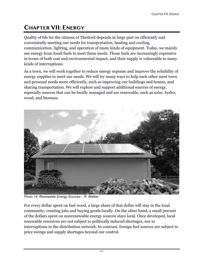
CHAPTER!VII:!ENERGY!!
92!
CHAPTER VII: ENERGY Quality of life for the citizens of Thetford depends in large part on efficiently and conveniently meeting our needs for transportation, heating and cooling, communication, lighting, and operation of many kinds of equipment. Today, we mainly use energy from fossil fuels to meet these needs. Those fuels are increasingly expensive in terms of both cost and environmental impact, and their supply is vulnerable to many kinds of interruptions.
As a town, we will work together to reduce energy expense and improve the reliability of energy supplies to meet our needs. We will try many ways to help each other meet town and personal needs more efficiently, such as improving our buildings and homes, and sharing transportation. We will explore and support additional sources of energy, especially sources that can be locally managed and are renewable, such as solar, hydro, wood, and biomass.
!Photo 14: Renewable Energy Sources – R. Walker
For every dollar spent on fuel wood, a large share of that dollar will stay in the local community, creating jobs and buying goods locally. On the other hand, a small percent of the dollars spent on nonrenewable energy sources stays local. Once developed, local renewable resources are not subject to politically induced shortages, nor to interruptions in the distribution network. In contrast, foreign fuel sources are subject to price swings and supply shortages beyond our control.
CHAPTER!VII:!ENERGY!!
93!
The most abundant local energy “source” is conservation. This is available to us and with no degradation to our natural environment.
While the Planning Commission recognizes that energy supply and demand are directed largely by economic forces at the state, federal, and international levels, the manner in which Thetford plans for future growth can have an impact on energy. For example, a highly dispersed and unplanned pattern of land use can waste both land and energy resources. By planning the location of jobs, public services, and housing in close proximity to growth centers, the consumption of transportation fuel and the needs for additional roads can be reduced. Thoughtful siting and design of buildings and the selection of highly efficient energy systems can reduce the energy needed.
Thetford will need to balance concerns about impacts of development with the local and non-local environmental impacts of our energy use.
This chapter includes analysis of our resources and needs in terms of scarcity and cost. It also contains statements of policy on the conservation of energy, on the development of renewable energy sources, and on patterns of density and land use to support the conservation of energy. As citizens and neighbors, we have the power to decide which actions we will try first, how to share what we learn, and how to ensure Thetford remains a great place to live. Figure 16: Vermont Energy Use by Sector, 2013
Source: US Energy Information Administration, 2013
ENERGY CURRENT DEMANDS In terms of per capita energy consumption for residential and transportation purposes, Vermont is about the same as the rest of the US. In Vermont, 31% of the state’s total energy use is taken by the residential sector, and of that almost 80% is dedicated to space heating and domestic hot water. The transportation sector uses 34% of the state’s total energy use, with over 50% of the transportation energy used to fuel private cars for residents (as opposed to being used for public transit, road maintenance, or another public purposes). The remaining 35% of state energy usage is taken by the commercial and industrial sectors.
According to data on average annual electric energy use collected by Efficiency Vermont in 2011, the Town of Thetford ranks thirteenth from the top when compared with 30 towns in the Two Rivers-Ottauquechee region. In 2011, Thetford used an average of 6,895 kWh per residence.
Residential!32%!
Commercial!19%!Industrial!12%!
Transportation!37%!
CHAPTER!VII:!ENERGY!!
94!
CURRENT ENERGY SOURCES
Non-renewable Sources
FOSSIL FUELS
Thetford, like Vermont as a whole, depends primarily on fossil fuels for heat and transportation. Fossil fuels account for more than 50% of all energy consumed in Vermont, most of which is used in transportation.
NUCLEAR
As of July 2015, Vermont’s largest utility receives 9% of its mix from nuclear-generated power from Seabrook, NH.
Renewable Sources Vermont has a voluntary goal of generating 25% of electricity consumed in the state from renewable energy resources by 2017 and 75% by 2032. The term “renewable energy” refers to energy supplied by sources that are naturally and continually replenished, such as wind, solar, geothermal (using the earth’s heat to create power), hydropower, and various forms of biomass (trees, crops, manure, etc.). Although initial set up costs for renewable energy generation systems can be high, these systems can save users money over the long term, and they reduce the consumption of carbon-based fuels, which helps to protect our environment and reduce our reliance on centralized energy. In Vermont, some of these energy sources are more readily available than others and some are cost effective for the individual energy producer.
The types of renewable energy found in Vermont are solar, wind, biomass, and hydro.
SOLAR ENERGY
Solar energy has potential for providing clean, reliable, and safe energy, even in Vermont’s climate. Most areas in Vermont have the potential for some solar energy production, at least at the residential scale. State statute forbids the creation of land use regulations that prohibit renewable energy generation.
Electricity Generation – The cost of installing solar electricity generation has decreased sharply in the last five years. Thetford Elementary School has installed the first large-scale solar electric generation facility in Thetford. There are no commercial-scale solar electricity generation facilities in Thetford. Future commercial solar facilities should be developed in ways that avoid undue adverse impacts on the rural character of the area in which they are proposed to be located. Developers should make all possible efforts to minimize damage to important natural areas including those identified in the Natural Resource chapter of this Plan.
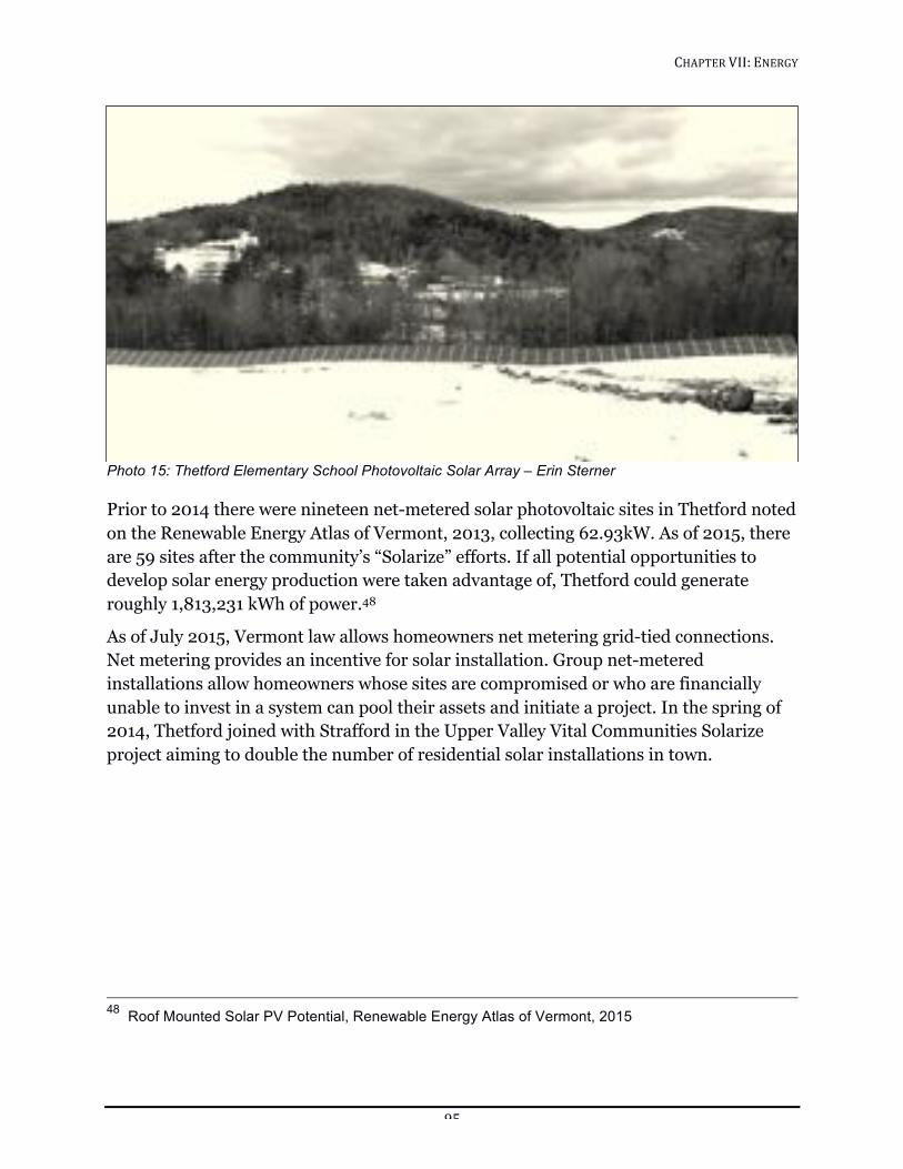
CHAPTER!VII:!ENERGY!!
95!
!Photo 15: Thetford Elementary School Photovoltaic Solar Array – Erin Sterner
Prior to 2014 there were nineteen net-metered solar photovoltaic sites in Thetford noted on the Renewable Energy Atlas of Vermont, 2013, collecting 62.93kW. As of 2015, there are 59 sites after the community’s “Solarize” efforts. If all potential opportunities to develop solar energy production were taken advantage of, Thetford could generate roughly 1,813,231 kWh of power.48
As of July 2015, Vermont law allows homeowners net metering grid-tied connections. Net metering provides an incentive for solar installation. Group net-metered installations allow homeowners whose sites are compromised or who are financially unable to invest in a system can pool their assets and initiate a project. In the spring of 2014, Thetford joined with Strafford in the Upper Valley Vital Communities Solarize project aiming to double the number of residential solar installations in town.
48 Roof Mounted Solar PV Potential, Renewable Energy Atlas of Vermont, 2015
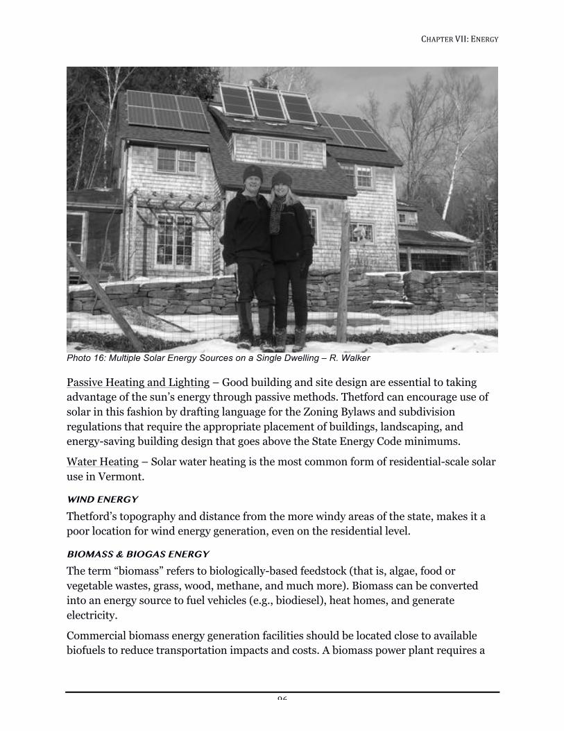
CHAPTER!VII:!ENERGY!!
96!
!Photo 16: Multiple Solar Energy Sources on a Single Dwelling – R. Walker
Passive Heating and Lighting – Good building and site design are essential to taking advantage of the sun’s energy through passive methods. Thetford can encourage use of solar in this fashion by drafting language for the Zoning Bylaws and subdivision regulations that require the appropriate placement of buildings, landscaping, and energy-saving building design that goes above the State Energy Code minimums.
Water Heating – Solar water heating is the most common form of residential-scale solar use in Vermont.
WIND ENERGY
Thetford’s topography and distance from the more windy areas of the state, makes it a poor location for wind energy generation, even on the residential level.
BIOMASS & BIOGAS ENERGY
The term “biomass” refers to biologically-based feedstock (that is, algae, food or vegetable wastes, grass, wood, methane, and much more). Biomass can be converted into an energy source to fuel vehicles (e.g., biodiesel), heat homes, and generate electricity.
Commercial biomass energy generation facilities should be located close to available biofuels to reduce transportation impacts and costs. A biomass power plant requires a
CHAPTER!VII:!ENERGY!!
97!
great deal of space to accommodate the various stages of collection and conversion of the mass into fuel before burning it to produce electricity. Water can also pose a problem because biomass facilities require large quantities of water to handle the recycling process of waste materials. Feedstock materials have to be transported to the facility, so truck or train traffic is a consideration in selecting a site. Smaller scaled heating facilities that produce hot water only can be set up as “heating districts” and serve multiple facilities grouped in close proximity to each other, encouraging high density village development (i.e., elementary school, fire station, library/museum, post office, church). Vermont’s Clean Energy Development Fund (CEDF) 2015 program budget is providing incentives for heating that might be considering a biomass type of project. An example of a community supported project for a biomass boiler took place at Craftsbury Academy on Craftsbury Common, Vermont and the downtown core area in Montpelier.
Wood Heating: According to the 2011 Vermont Comprehensive Energy Plan, those using wood for primary heating consumed about 5.4 cords in 2007–08, while those using wood as a supplementary source used 2.25 cords. In that same year, Vermont households burning wood pellets burned a total of 20,155 tons. Those using wood pellets as a primary-heat-source consumed 3.8 tons per household, while supplementary-heat-source consumers burned 1.2 tons for the season.
Thetford is largely forested. Prior to the wide-scale use of fossil fuels, all of Thetford was wood heated. Thetford contains enough forested land to produce sufficient fuel wood for those who continue to heat their homes with wood. With good planning and management, this can be done on a sustainable basis.
Biofuels: In addition to using biomass for heating, the use of biofuels, particularly biodiesel, is becoming an increasingly popular option for municipalities to cut costs and reduce the environmental impact of vehicle emissions.
BIODIESEL – According to the Vermont Biofuels Association, biodiesel is a clean burning alternative fuel, produced from domestic, renewable resources such as soybeans, sunflowers, canola, waste cooking oil, or animal fats. Biodiesel contains no petroleum, but it can be blended at any level with petroleum diesel to create a biodiesel blend, which is often used in colder weather. It can be used in compression-ignition (diesel) engines or oil-fired boilers or furnaces with little or no modifications.
Growing biomass feedstock to use in biofuels may be a viable way to encourage farming in Thetford, however, balance should be sought between growing for energy demands and for human and animal consumption.
BIOGAS (COW POWER) — Agriculture has the potential to become a net generator of energy through biomass as well. Raising crops for biofuels is one of the more productive and environmentally safe methods of agricultural energy generation. Methane digestion,
CHAPTER!VII:!ENERGY!!
98!
where the methane from manure is used to power a turbine, is another potential way farms can generate power, however, these facilities have only been effective when utilized by large scale farming in the US. Farms often have their own set of potentially adverse environmental impacts and would require additional examination before consideration could be given for this new source of energy in Thetford. European advances in biomass energy production on small farms might be applicable to local projects. One of farms in Green Mountain Power’s Cow Power program is Green Mountain Dairy, a 950 head dairy farm that produces 300 kW of power, enough to serve 350 homes.
One of the key advantages to methane digestion is that it reduces the amount of methane released into the environment. Methane is approximately 20 times more potent as a greenhouse gas than carbon dioxide. If interest from the remaining dairy farms in the community is strong and financial support is available, these options should be considered.
HYDROPOWER
Many locations in Vermont, including Thetford, once depended on hydropower to grind grain, run mills and even supply electricity to homes. Thetford Center, Post Mills, Rice’s Mills, and several other locations in Thetford became thriving communities based on waterpower. Most of these small-scale power generation facilities have been retired and Thetford’s hydroelectricity now comes from massive hydro facilities such as Hydro Quebec. No electricity is commercially produced by hydropower in Thetford, but the potential still exists for projects at Union Village (600-1500kW), Thetford Center (350kW), Post Mills and Rice’s Mills (100kW), and the outlet dam of Lake Fairlee (50kW).
There are two main forms of hydropower: run-of-river, which uses the natural flow of water to generate power, and facilities that store water behind a dam. Run-of-river systems rely on seasonal rainfall and runoff to produce power, resulting in periods of low production. Impounding water behind a dam allows control of the water flow, resulting in consistent electric production.
There are three sites (two on the Ompompanoosuc and one on Avery Brook) in Thetford that are considered “in-service”, meaning that they are not actively producing power, but have the basic infrastructure to do so. Retrofitting these existing sites presents the most effective means of adding hydropower while keeping environmental impacts low.
Hydroelectric development necessitates balancing priorities. While the benefits of generating electricity from local renewable resources are evident, they have associated costs. The power output from a given stream must be moderated by environmental considerations. A minimum stream flow, adequate to support aquatic life forms, must
CHAPTER!VII:!ENERGY!!
99!
be maintained and impoundments must be designed with water quality, land use, and recreation considerations in mind.
Hydropower generating facilities are regulated by the Federal Energy Regulatory Commission and stringent federal water quality standards. As a result, the regulatory process for hydro facilities is extensive and time consuming. Streams are public trust resources and the potential impacts of hydro projects warrant significant consideration. Any hydropower development proposed in Thetford shall not result in an undue adverse impact to riverine ecosystems and water quality.
Permitting Considerations Energy generation in Vermont is subject to a number of different permitting requirements, most of which are limited to state level permitting. On the municipal level, state statute protects residential renewable energy generation systems from regulations that will completely prohibit their development.
The energy generation siting process outlined in 30 V.S.A. § 248 and in 24 V.S.A. § 4302 is currently being modified by the state legislature based on recommendations from the Vermont Generation Siting Policy Commission. In order to have formal standing in the approval process for siting of such projects, the Town Plan’s Energy Chapter must contain specific language regarding the location within Thetford of appropriate sites for renewable energy generation. The language guidelines, which will be included in the Energy Development Improvement Act (Senate bill S.230), are expected to be available in the fall of 2016. As soon as possible after the guidelines become available, the Planning Commission should make whatever additions and adjustments are needed to make the language specific to Thetford's situation, amend the Energy Chapter to include the language, and receive certification from the town's regional planning commission.
DECREASING ENERGY NEED There are a number of ways that Thetford can meet its energy demand locally, first by lowering that demand, and then by working to meet the remaining need with local, renewable energy resources.
Changing Behavior Raising awareness about wasteful energy behaviors and energy saving behaviors reduces the strain on existing energy resources and helps residents and businesses save money, making the town a more affordable place to live with a higher quality of life.
Implementing Energy Efficiency Current state building codes set the minimum standard for energy efficiency, while building programs like “Net Zero” and “Passive House” can achieve up to 80% or more
CHAPTER!VII:!ENERGY!!
100!
energy savings above the minimum standard and should be encouraged by implementing the following:
1. Insulate with high R-value (or heat flow resistance) material
2. Seal gaps, holes and air penetrations through the walls, ceilings and floors
3. Use high efficiency windows
4. Install energy efficient appliances like refrigerators, freezers, front loading washing machines, moisture sensing driers, and high-efficiency ground or air source heat pumps for heating and cooling.
5. Use high efficiency lighting (LED)
6. Use heat pumps or solar hot water heaters
7. Site buildings to make use of existing wind blocks and natural cooling patterns derived from the landscape’s topography
8. Site buildings with maximum southern exposure to capture passive solar energy
New residential development in the State of Vermont is required to comply with Vermont Residential Building Energy Standard (RBES). Commercial development is subject to similar code regulations. Development, which is required to meet the RBES includes:
1. Detached one- and two-family dwellings
2. Multi-family and other residential buildings three stories or fewer in height
3. Additions, alterations, renovations and repairs (new only)
4. Factory-built modular homes (not including mobile homes)
If a home required to meet the RBES does not comply, a homeowner may seek damages in court.
MUNICIPAL ROLE IN ENERGY EFFICIENCY
Thetford Energy Committee The Thetford Energy Committee (EC) is a volunteer group appointed by the Selectboard for the purpose of establishing and implementing the Town’s energy goals and advising the Selectboard and Planning Commission on all things energy-related. Thetford’s Energy Committee is very active; their work includes conducting energy audits on municipal buildings, tracking energy use for these buildings, and working with the Planning Commission on this chapter of the Town Plan.
CHAPTER!VII:!ENERGY!!
101!
Auditing Municipally Owned Buildings Thetford owns buildings that are old and inefficient, for instance with insufficient insulation and thermal passes, wasteful heating and cooling systems, and out-of-date lighting. These kinds of infrastructure problems result in high energy use. The resulting cost is passed onto taxpayers. Audits on Town buildings help determine what improvements are necessary, and which projects have the highest cost-benefit ratio in terms of energy and financial savings.
Property-Assessed Clean Energy (PACE) Vermont enacted legislation in May 2009 (Act 45) that authorizes local governments to create Clean Energy Assessment districts. Thetford voted to become a PACE district in 2011. This allows Thetford to offer financing to property owners for renewable energy and energy-efficiency projects. Eligible projects include the installation of solar water and space heating, photovoltaic panels (PV), and biomass heating, small wind, and micro-hydroelectric systems. Property-Assessed Clean Energy (PACE) financing effectively allows property owners to borrow money to pay for energy improvements. The amount borrowed is typically repaid via a special assessment on the property over a period of up to 20 years. If the property owner wishes to sell the parcel before fully repaying the obligation, then the obligation is transferred to the new property owner at the time of sale.
Policy
LAND USE
The Vermont Municipal and Regional Planning and Development Act (24 V.S.A. Ch. 117) does not allow communities to impose land use regulation that prohibits or has the effect of prohibiting the installation of solar collectors or other renewable energy devices. The statute does enable Vermont’s municipalities to adopt regulatory bylaws, such as zoning and subdivision regulations, for implementing the energy provisions contained in their town plan.
Zoning bylaws control the type and density of development. Thetford’s Zoning Bylaws contain provisions for planned unit developments (PUDs). PUDs are a grouping of mixed use or residential structures, pre-planned and developed on a single parcel of land. The setback frontage and density requirements of the zoning district may be varied, to allow creative and energy efficient design (i.e., east-west orientation of roads to encourage southern exposure of structures, solar access protection, use of land forms or vegetation for wind breaks, and attached structures), and to encourage the construction of energy efficient buildings.
Subdivision regulations are one of the most effective tools for encouraging energy efficiency and conservation. Subdivision regulations, like PUDs, involve Town review
CHAPTER!VII:!ENERGY!!
102!
through the Development Review Board in the design process. Because subdivision regulations govern the creation of new building lots, as well as the provision of access and other facilities and services to those lots, a community can impose requirements that a developer site their building to maximize solar gain. Likewise, subdivision can require that landscaping be utilized to reduce thermal loss.
TRANSPORTATION
It is important that communities recognize the clear connection between land use patterns, transportation, and energy use. Most communities encourage the development of residences in rural areas, and these are coveted locations because of the aesthetics that make Vermont special. However, this rural development requires most of our population to drive to reach schools, work, and services.
Because transportation is such a substantial portion of local energy use, it is in the interest of the community to encourage any new developments that are proposed in town to locate adjacent to existing roads. In particular dense residential developments should be located within or adjacent to existing village centers or within designated growth areas. Commercial development that requires trucking and freight handling should only occur on roads that can effectively handle the size of vehicle needed.
Since road maintenance and school bus service make up the greatest portion of the municipality’s energy costs, Thetford should limit road expansion and provide school busing through a policy that maximizes energy efficiency, while maintaining safety considerations. Most transportation throughout the town of Thetford is by private vehicle. Consideration for alternative transportation and ride sharing should be encouraged and supported for all major town events and gatherings.
ENERGY ASSURANCE PLANNING
If the costs of petroleum were to double, Thetford would be challenged in continuing to offer services and taxpayers would be forced to absorb those rising costs. This, coupled with the impact such fuel cost price changes would have on the private sector, could spell disaster for any part of the United States. Additional concerns lie in our ability to maintain our existing energy distribution systems in the event of a severe hazard event. The State of Vermont has seen an increase in the number of declared disasters over the past decade. In 2011, Tropical Storm Irene isolated a number of communities, keeping them from available fuel sources.
Thetford should engage in comprehensive, integrated energy assurance planning that is designed to mitigate and enable timely response to energy supply disruption, whether it be shortages created by cost or by hazard events. Our Municipal Hazard Mitigation Plan should include an element that specifically addresses fuel shortages. To ensure that there is a comprehensive approach to energy assurance planning, Thetford should
CHAPTER!VII:!ENERGY!!
103!
assess impacts to the local supply and distribution system in the event of a fuel shortage. This plan should include a clear set of non-mandatory and mandatory fuel conservation measures. These measures are designed to alleviate supply shortages or disruptions and potentially prevent a more serious crisis. For more extreme events, communities should be prepared to implement a fuel allocation program that ensures available fuel being distributed to priority areas, such as emergency response and health care providers.
GOALS, POLICIES AND RECOMMENDATIONS Goal
Foster a sustainable energy future that minimizes environmental impact, supports our local economy, emphasizes energy conservation and efficiency, and increases use of local and regional renewable energy sources.
Policies
1. Encourage a pattern of settlement and land use that uses energy efficiently.
2. Promote the construction of energy efficient homes and buildings to lessen or eliminate the need for costly sources of additional energy.
3. Coordinate land-use and transportation planning that promotes energy efficient transportation, both private and public.
4. Encourage the development of renewable energy generation that is sustainable and protects our natural and rural landscape.
5. Support partnerships, strategies, and state and federal legislation that will ensure the affordable, reliable, and sustainable production and delivery of electrical power to the region.
6. Model responsible energy use through municipal actions, decisions, purchases, and projects.
7. Situate major public investments, such as schools, public recreational areas, and municipal facilities, as well as major commercial or residential developments within or in close proximity to the village(s).
8. Support the development of broadband services, energy efficient home occupation, and small-scale home business.
9. Encourage and promote sustainable fuel-wood production and improved forest management.
CHAPTER!VII:!ENERGY!!
104!
Recommendations
1. The Town should participate in the Public Service Board’s review of new and expanded generation and transmission facilities to ensure that local energy, resource conservation, and development objectives are identified and considered in future utility development.
2. As soon as possible after the energy generation siting guidelines become available, the Planning Commission should make whatever additions and adjustments are needed to make the language specific to Thetford's situation, amend the Energy Chapter to include the language, and receive certification from the town's regional planning commission.
3. The Town should develop local emergency contingency plans that ensure access to critical energy supplies and measures to reduce nonessential energy consumption in the event of an abrupt energy shortage in cooperation with state, regional, and local agencies, emergency service providers, regional suppliers and municipalities.
4. The Town should support the Thetford PACE program and other similar statewide programs designed to make energy efficiency improvements more affordable and more likely to be implemented.
5. The Town should provide educational outreach to communities to better educate homeowners on resources available to them for energy efficiency improvements.
6. The Town should promote and implement strategies to encourage ride sharing, public transit, bicycling, and walking.
7. The Town should promote the development and use of a system of trails, greenways, sidewalks, bicycle paths, and commuter lots as viable transportation options and pursue federal and state funding for their construction, particularly during road improvement or expansion decisions.
8. The Town should review and adopt zoning regulations that support development of mixed use growth centers containing daily services to residences as a way to reduce transportation needs.
9. The Town should conduct complete energy audits of all Town buildings to identify areas of energy waste and areas of potential savings.
10. The Town should construct all new municipal buildings according to standards of energy efficiency better than state energy codes.
11. The Town should incorporate life-cycle analysis into the Town’s Capital Budget planning. Use life-cycle analysis to evaluate decisions concerning the purchases of any Town equipment, vehicles, or other items requiring energy consumption.

CHAPTER!VII:!ENERGY!!
105!
12. The Town should review and adopt zoning bylaws and subdivision regulations to promote good building and site design to take advantage of the sun’s energy through passive methods. E.g., appropriate placement and orientation of buildings, landscaping and energy-saving building design.
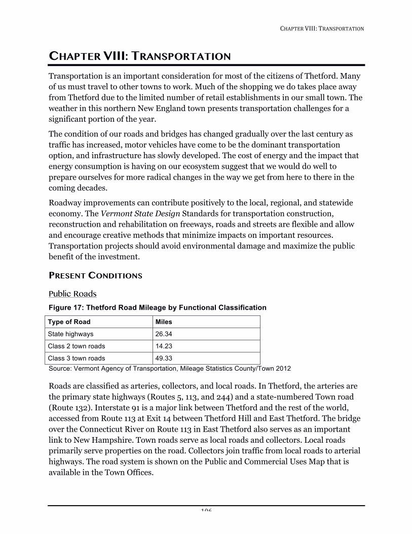
CHAPTER!VIII:!TRANSPORTATION!!
106!
CHAPTER VIII: TRANSPORTATION Transportation is an important consideration for most of the citizens of Thetford. Many of us must travel to other towns to work. Much of the shopping we do takes place away from Thetford due to the limited number of retail establishments in our small town. The weather in this northern New England town presents transportation challenges for a significant portion of the year.
The condition of our roads and bridges has changed gradually over the last century as traffic has increased, motor vehicles have come to be the dominant transportation option, and infrastructure has slowly developed. The cost of energy and the impact that energy consumption is having on our ecosystem suggest that we would do well to prepare ourselves for more radical changes in the way we get from here to there in the coming decades.
Roadway improvements can contribute positively to the local, regional, and statewide economy. The Vermont State Design Standards for transportation construction, reconstruction and rehabilitation on freeways, roads and streets are flexible and allow and encourage creative methods that minimize impacts on important resources. Transportation projects should avoid environmental damage and maximize the public benefit of the investment.
PRESENT CONDITIONS
Public Roads Figure 17: Thetford Road Mileage by Functional Classification
Type of Road Miles
State highways 26.34
Class 2 town roads 14.23
Class 3 town roads 49.33 Source: Vermont Agency of Transportation, Mileage Statistics County/Town 2012 Roads are classified as arteries, collectors, and local roads. In Thetford, the arteries are the primary state highways (Routes 5, 113, and 244) and a state-numbered Town road (Route 132). Interstate 91 is a major link between Thetford and the rest of the world, accessed from Route 113 at Exit 14 between Thetford Hill and East Thetford. The bridge over the Connecticut River on Route 113 in East Thetford also serves as an important link to New Hampshire. Town roads serve as local roads and collectors. Local roads primarily serve properties on the road. Collectors join traffic from local roads to arterial highways. The road system is shown on the Public and Commercial Uses Map that is available in the Town Offices.
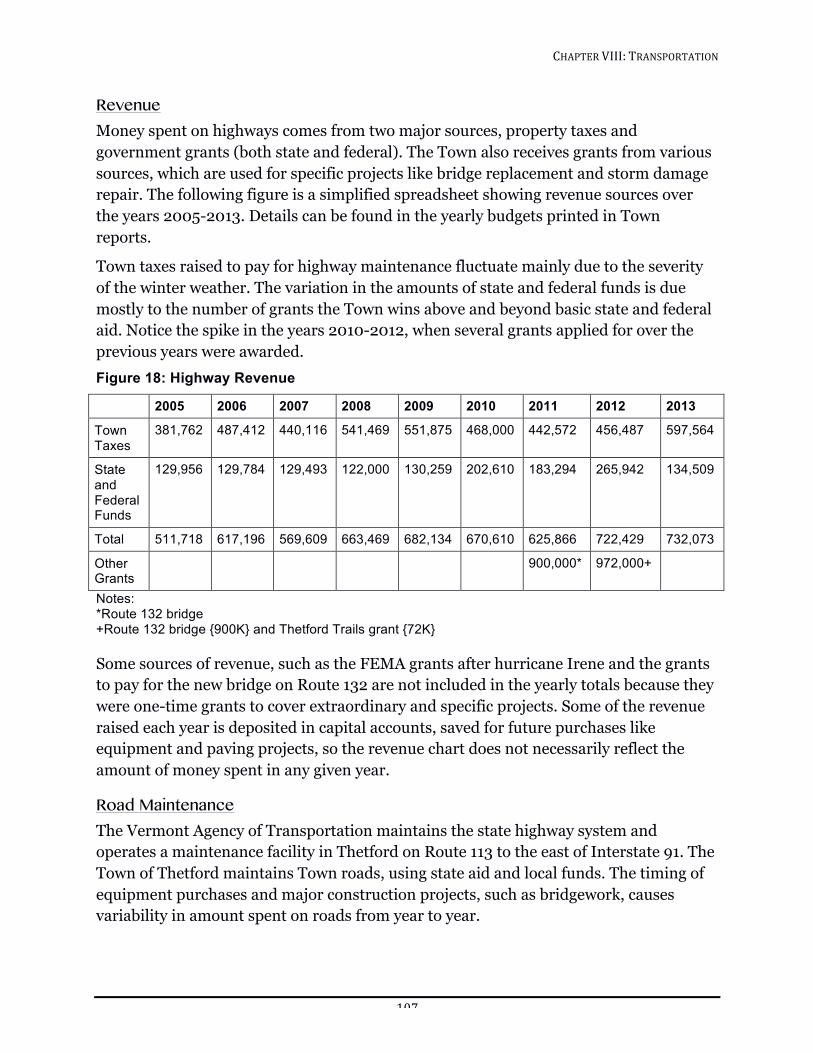
CHAPTER!VIII:!TRANSPORTATION!!
107!
Revenue Money spent on highways comes from two major sources, property taxes and government grants (both state and federal). The Town also receives grants from various sources, which are used for specific projects like bridge replacement and storm damage repair. The following figure is a simplified spreadsheet showing revenue sources over the years 2005-2013. Details can be found in the yearly budgets printed in Town reports.
Town taxes raised to pay for highway maintenance fluctuate mainly due to the severity of the winter weather. The variation in the amounts of state and federal funds is due mostly to the number of grants the Town wins above and beyond basic state and federal aid. Notice the spike in the years 2010-2012, when several grants applied for over the previous years were awarded. Figure 18: Highway Revenue
2005 2006 2007 2008 2009 2010 2011 2012 2013
Town Taxes
381,762 487,412 440,116 541,469 551,875 468,000 442,572 456,487 597,564
State and Federal Funds
129,956 129,784 129,493 122,000 130,259 202,610 183,294 265,942 134,509
Total 511,718 617,196 569,609 663,469 682,134 670,610 625,866 722,429 732,073
Other Grants
900,000* 972,000+
Notes: *Route 132 bridge +Route 132 bridge {900K} and Thetford Trails grant {72K} Some sources of revenue, such as the FEMA grants after hurricane Irene and the grants to pay for the new bridge on Route 132 are not included in the yearly totals because they were one-time grants to cover extraordinary and specific projects. Some of the revenue raised each year is deposited in capital accounts, saved for future purchases like equipment and paving projects, so the revenue chart does not necessarily reflect the amount of money spent in any given year.
Road Maintenance The Vermont Agency of Transportation maintains the state highway system and operates a maintenance facility in Thetford on Route 113 to the east of Interstate 91. The Town of Thetford maintains Town roads, using state aid and local funds. The timing of equipment purchases and major construction projects, such as bridgework, causes variability in amount spent on roads from year to year.
CHAPTER!VIII:!TRANSPORTATION!!
108!
Thetford’s subdivision regulations define a private road as “a privately owned access to three or more lots, sites or dwelling units.” The Planning Commission recommends that all private roads be built to minimum standards for a Town Class 3 road, and Thetford will not consider taking over a road that has not been built to those standards. The Town rarely takes over private roads, and does so only when the road is maintainable and there is sufficient traffic to warrant it.
Development on Class 4 roads is discouraged. Those developing on Class 4 roads are required to sign a waiver signifying that they understand that certain town services may be unavailable. In addition, any improvements to a Class 4 Town road must be performed up to Town standards, under the supervision of the Road Commissioner. The Class 4 road policy limits improvements on a per case basis.
Safety The Vermont Agency of Transportation analyzes accidents on state highways to detect areas with safety problems. It periodically publishes a compendium of “High Accident Locations.” The most recently published volume, 2008-2012, lists no Thetford road segments or intersections as high accident locations.
There are several actions that the Town should take to help assure safety. First, driveways should be located with safe sight distances. Any new driveway onto a state highway requires a driveway permit from the Vermont Agency of Transportation that conforms with Standard B-71 for Residential and Commercial Drives (7/8/05). This standard specifies minimum standards for grade, drainage, and corner sight distance. The corner sight distance is measured from a point on the drive at least 15 feet from the edge of traveled way of the adjacent roadway and measured from a height of eye of 3.5 feet on the drive to a high of 4.25 feet on the roadway. To ensure safety, it is important to trim vegetation at the corners and to enforce the speed limits.
Congestion Although traffic volumes will likely increase, it is unlikely that highway capacity will grow. There may be new local roads built to serve subdivisions, and some of the collector roads may be upgraded or paved, but the arterial system comprised of the state highways in twenty years will likely look very similar to today. It is important to note that the state highway system, the Interstate 91 interchange, and the East Thetford/Lyme bridge over the Connecticut River all serve regional traffic and will be affected by regional growth.
Transportation planners measure congestion on a level of service scale ranging from “A” to “F” as defined in the Highway Capacity Manual, published by the Transportation Research Board. Although no roadways or intersections in Thetford are congested now, and none are expected to be congested soon, policies should be adopted to assure that
CHAPTER!VIII:!TRANSPORTATION!!
109!
problems will not arise unexpectedly. Therefore, this Plan establishes a minimum acceptable level of service of “D” for the town for the “design hour”, defined as the thirtieth highest hour of traffic of the year.
Major proposed traffic generators in the town should provide a traffic study prepared by a qualified professional that demonstrates that the proposed project will not cause or contribute to a traffic condition worse than level of service “D.” Such studies should not be limited to the immediate access point, but should include all roadways that could be adversely affected. If transportation improvements are required, these improvements should be considered the responsibility of the developer.
A major traffic generator in Thetford is defined as a development generating 30 or more one-way (entering or exiting) peak hour trips. Trip generation statistics are provided for many land uses in Trip Generation, published by the Institute of Transportation Engineers. Examples of developments causing 30 peak hour trips would be 30 single-family residences, 50 apartments, 6,000 square feet of retail space, or 15,000 square feet of non-retail commercial space. Certain high traffic generators including fast food restaurants and convenience stores generate greater than 30 peak hour trips regardless of size. These are general guidelines. Traffic impact studies should be required for smaller developments where there are special concerns such as safety on a substandard road. In other cases, the requirement could be waived.
The area that is most likely to become congested is the center of East Thetford village. It lies at the crossing of two state highways between the two important regional links, Interstate 91 Exit 14 and the bridge to New Hampshire. It is the center of the community business district that has been designated as the area to encourage commercial growth. Although not congested now, the traffic capacity in East Thetford is rather limited. Because of the offset between the two Route 113 intersections, capacity probably can’t be increased much without a great investment.
Scenic Roads Route 5 and Academy Road are designated as Scenic Roads. See details in the Scenic Resources chapter.
TRANSPORTATION IN THE FUTURE Over the long term, more comprehensive and more direct bus service would be very desirable for Thetford residents wanting to reduce transportation costs and greenhouse gas emissions from automobiles. Possible routes include Route 113 from Post Mills or beyond to Route 5 south to Norwich and Hanover, and Route 5 from Fairlee through Thetford to Norwich and Hanover. In Hanover, connections can be made to destinations throughout the Upper Valley. Initiation of such a service would require substantial local
CHAPTER!VIII:!TRANSPORTATION!!
110!
interest as well as regional considerations and additional subsidy, which may be available from federal and state sources.
Stagecoach, based in Randolph, provides a wide range of contract bus services throughout Orange County, including Thetford. These buses are also open to the general public. The schedule is subject to change. Current schedules are available at the Town office. Stagecoach also operates the Vermont Rideshare program in Orange County. Anyone wishing to provide rides, needs rides, or wants to save money through sharing rides can call 1-800-685-7433 or go to http://www.vermontrideshare.org/.
The Vermont Agency of Transportation maintains a park and ride lot on the southeast corner of Interstate 91 Exit 14, with space for about 30 cars. This lot is well located. It appears to get a fair amount of use with capacity for more users.
Bicycle activity is quite significant on the state highways during summer months, particularly on Route 5. Riders include commuters, athletes (e.g., Dartmouth College racers), fitness riders, recreational riders, organized benefit tours, and tourist groups. Additionally, roller skiers and skaters are making increasing use of Town roads. The Town should seek to increase opportunities for and improve the safety of non-motorized travel and expand highway, pedestrian, and bicycle safety education.
As the price of energy rises, more Thetford residents will come to rely on bicycles and other non-motorized means of travel to work, on errands, and for recreation. The many trails, logging roads, and Class 4 roads (including those in the State Forest and the Union Village Dam area) will become an even more valuable network of car-free, shortcut byways for those trying to get from place to place without using motor vehicles. The wide variety of bicycles, tires, fenders and cold weather clothing available today has expanded the range of possibility for bikers to the point where hardy commuters can ride to work in places like Norwich, Hanover, White River, and Lebanon on almost any day of the year. The Town should begin to think of its tertiary byways as an important part of its transportation network and support this system whenever possible. Trails should be kept open for their intended purpose and connected to each other when possible.
Over the long-term, consideration should be given to pedestrian access in Thetford’s villages, particularly in the East Thetford community business district. Many short automobile trips from one business to another in East Thetford village might be eliminated if the area felt safe and comfortable to pedestrians. Pedestrian amenities could include crosswalks and sidewalks.
CHAPTER!VIII:!TRANSPORTATION!!
111!
GOALS, POLICIES AND RECOMMENDATIONS Goals
1. Maintain a safe and durable road system.
2. Prevent congestion on town roads.
3. Increase the use of public transit and ridesharing.
4. Improve pedestrian access in Thetford’s villages.
Policies
1. Maintain a minimum “D” level of service on all roads in town, including state highways.
2. Maintain Class IV roads according to state standards in order to avoid erosion and other damage to water resources and abutting land.
3. Development on Class IV roads should be discouraged, but if development occurs, the roads must be improved to Town standards, at developer’s cost.
4. Driveways accessing Town roads must meet state driveway standards. There must be room to turn around in the driveway so that cars are not backing out into the road.
5. Widen Class III roads to the standards set forth for street design in the Thetford Subdivision Regulations.
6. Require those proposing major traffic generators and expansions to prepare traffic impact studies.
7. Support improved bus transit, ridesharing, and bicycling options including more vans and buses, more commuter lots and safer bike routes.
Recommendations
1. The Town should install warning signs near narrow or otherwise dangerous spots on Town roads.
2. The Town should consider more blacktopping on hills, missed sections like T8 Gove Hill, T12 Lake Shore Drive and T11 Robinson Hill Road at the south end of Lake Fairlee, after weighing economics and neighborhood desire to maintain rural character.
3. The Town should install sidewalks and crosswalks in the East Thetford business district.
4. The Town should encourage and enforce lower speed limits in the villages.
CHAPTER!VIII:!TRANSPORTATION!!
112!
5. The Town should discuss with Stagecoach and other providers the possibility of establishing van routes to the Hanover/Lebanon/White River area that originate in Thetford or in adjacent towns, so that residents can rely on this service on a regular basis.
6. The Town should investigate the possibility of getting one or more Zip Cars based in Thetford.
7. The Town should continue to coordinate land-use and future transportation planning that promote energy-efficient and cost-efficient transportation.
8. The Town should direct the Energy Committee to educate Thetford residents about energy efficient transportation by promoting and implementing strategies to encourage ridesharing, public transit, bicycling, and walking.
9. The Town should work with major employers in town and the region to promote energy-efficient commuting and possible ride discounts to those using public transportation.
10. The Town should promote the development of commuter parking lots, with particular attention given to connecting schools, recreation facilities, shopping centers, major places of employment, and mass transportation facilities. This could be accomplished through tax incentives or by acquiring easements.
11. The Town should coordinate with the State Highway Department to better accommodate bicyclists and walkers during the planning and upgrading of State roadways within the community. This effort will encourage cost efficient and safer options for travel between the various villages and service locations.
12. The Town should provide educational and recreational programs for children and adults emphasizing highway, pedestrian, and bicycle safety.
CHAPTER!XI:!HISTORIC!RESOURCES!!
113!
CHAPTER XI: HISTORIC RESOURCES Trying)to)plan)for)the)future)without)a)sense)of)the)past)is)like)trying)to)plant)cut)flowers.))
– Daniel Boorstin, former Librarian of Congress
The area along the Connecticut River where Thetford’s villages sit today has been visited by humans for 11,000 years and occupied since at least the 1600’s, when the Abenaki people and European travelers and settlers used the Connecticut River, the Ompompanoosuc River, and Lake Fairlee as transportation routes and sources of power. Our rivers helped shape a settlement pattern that created seven individual village centers—Thetford Hill, Thetford Center, Post Mills, Rice’s Mills, Union Village, East Thetford, and North Thetford— all of which retain some of the distinct identities they developed when it took people significant time to travel from one village to another. Thetford’s historic resources include a wealth of early 19th-century frame, brick, and stone residences, covered bridges, and stately religious structures. Historic resources, both structures and artifacts, are particularly valuable because they are nonrenewable; they may be preserved or may vanish with a single action.
THETFORD’S HISTORIC STRUCTURES AND SITES Historic structures and sites that survive from earlier periods provide a visual record of Thetford’s history, contribute to the individuality of our town, lend a sense of continuity to our lives, and contribute to the sense of beauty and grace many find in Thetford.
Thetford’s pattern of settlement around many small villages means our rich legacy of public and institutional structures are scattered throughout the town. These structures, which are important architecturally, visually, and historically, contribute to Thetford’s sense of the past. Happily many are also part of today’s available community space.
A number of actions have been taken over the years preserve our historic buildings. For generations many residents have expressed appreciation for Thetford’s history by maintaining homes and community buildings. In 1979, the Vermont Division for Historic Preservation surveyed two (of a possible six) districts and more than 100 Thetford buildings (including some outside the two districts). The survey selected areas and buildings significant for their historic and architectural associations. The two districts surveyed were the Thetford Center Historic District (57 structures) and the Thetford Hill Historic District (35 structures).
1. The Thetford Center Historic District includes the Thetford Center Community Building (nominated as part of the Thetford Center National Historic District and included in the Vermont Historic Sites and Structures Survey), and Thetford Town Hall (built in 1830 as a one-story red brick meeting hall and listed on the National Register of Historic Places).
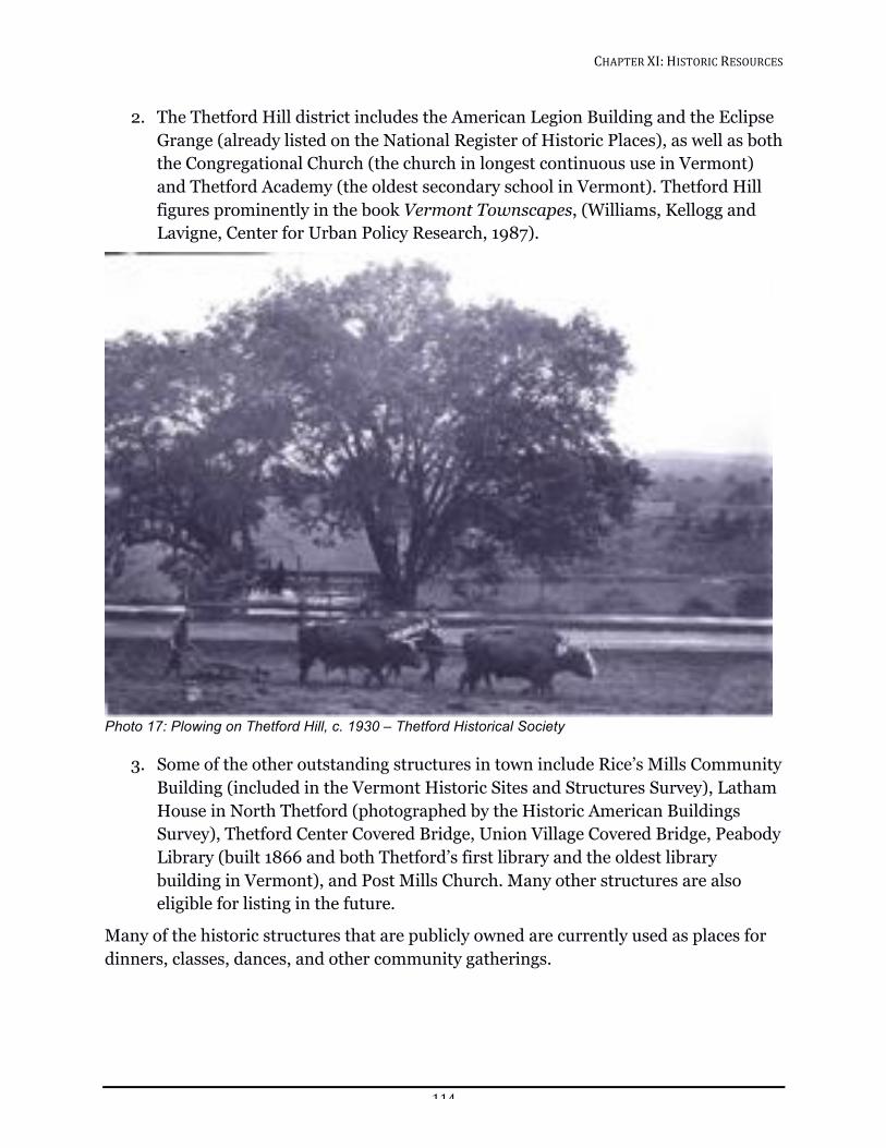
CHAPTER!XI:!HISTORIC!RESOURCES!!
114!
2. The Thetford Hill district includes the American Legion Building and the Eclipse Grange (already listed on the National Register of Historic Places), as well as both the Congregational Church (the church in longest continuous use in Vermont) and Thetford Academy (the oldest secondary school in Vermont). Thetford Hill figures prominently in the book Vermont Townscapes, (Williams, Kellogg and Lavigne, Center for Urban Policy Research, 1987).
!Photo 17: Plowing on Thetford Hill, c. 1930 – Thetford Historical Society
3. Some of the other outstanding structures in town include Rice’s Mills Community Building (included in the Vermont Historic Sites and Structures Survey), Latham House in North Thetford (photographed by the Historic American Buildings Survey), Thetford Center Covered Bridge, Union Village Covered Bridge, Peabody Library (built 1866 and both Thetford’s first library and the oldest library building in Vermont), and Post Mills Church. Many other structures are also eligible for listing in the future.
Many of the historic structures that are publicly owned are currently used as places for dinners, classes, dances, and other community gatherings.
CHAPTER!XI:!HISTORIC!RESOURCES!!
115!
THETFORD’S HISTORIC ARTIFACTS The history of a town is more than the historic structures that remain. It is also collective memory from earlier days, captured in story and song, paintings and photographs. In addition to the care taken of homes by homeowners, churches by parishioners, and schools by students, teachers, parents and boards, a variety of individuals and groups have taken responsibility for local preservation and history-focused activities. The Thetford Historical Society (THS) has taken the lead in collecting and displaying stories and objects from earlier days, protecting these artifacts of our collective memory.
THS was organized in 1943 and has approximately 200 members. The THS collection, housed in the Thetford Bicentennial Building and the Hughes Barn Museum, is catalogued with a card index, and includes artifacts, manuscripts, letters, ledgers, and photographs, as well as books. The THS library consists of approximately 4,000 volumes, which may be used on site for research. The THS works cooperatively with staff at the Library of Congress to enter information on their holdings into the National Union Catalog of Manuscript Collections (NUCMC) system for increased accessibility to researchers. Digital versions of guides of the larger collections in the THS library are available through the THS website.
In order to protect them, materials in the THS archives are encased in acid-free folders, boxes, or photograph slips. Genealogical files and subject files are growing, and are used both by townspeople and families from all over the country. The THS library maintains regular hours throughout the year, and is also open by appointment. The THS Board of Trustees meets regularly, with an annual meeting in October. Public programs of local historical interest are offered throughout the year.
In addition to the library, the THS owns the Charles and Fannie Hughes Barn Museum on Route 113, which is open to the general public on five Sundays during August and September and to local school classes in the early fall. Students at both Thetford Elementary School and Thetford Academy are introduced to the collections in the museum and the library.
The THS creates exhibits for and participates in the Vermont History Expo, sharing stories unique to Thetford with a statewide audience. Exhibits are also displayed at Town Hall, Thetford Academy, and Thetford Elementary School, Latham Gallery, and at the Barn Museum. Walking tours of two villages, including use of historic photographs, have been completed and more are planned. Ongoing activities include collecting and processing manuscripts, answering genealogical questions, and receiving and displaying objects related to Thetford history. The THS also acts as repository for material from a number of local organizations.
CHAPTER!XI:!HISTORIC!RESOURCES!!
116!
TOOLS FOR HISTORICAL PRESERVATION A variety state and private agencies and programs can be useful when planning and implementing historic preservation projects.
Private Citizens and Organizations Private individuals or groups undertake much of the responsibility for historic preservation. Considering the town’s high proportion of older housing units, pride in ownership and regular maintenance alone can be responsible for remarkable results. Unfortunately, improvement work undertaken with good intentions can often result in techniques or materials inconsistent or insensitive to an older building. As a result, the integrity of the building is compromised and work done may actually damage the building it was intended to preserve, often proving more expensive than the proper treatment.
Historic Resources Survey Preservation through documentation is perhaps the most basic, essential, and non-controversial of preservation strategies. There are several advantages in undertaking an historic resources survey. In addition to providing a permanent written and photographic record of a town’s architecture, a good inventory is the foundation for other preservation tools and can be used to establish design control districts or to prepare nominations for the listing of historic structures in the National Register of Historic Places. Data gathered in a survey may encourage a greater appreciation of the built environment by local citizens. Historic resource assessments are also necessary for accomplishing environmental reviews required in projects receiving federal funding. As the beginning of a comprehensive historic preservation strategy, information gathered should act as a firm base for future decision-making by identifying buildings suitable for and worthy of rehabilitation. Since the late 1960’s the Vermont Division for Historic Preservation has conducted the State Historic Sites and Structures Survey on a systematic town-by-town basis. State and Federal law mandates the survey. About 90 percent of the State has been inventoried, and the survey contains information on more than 20,000 of the State’s historic resources. In 1979 the Division prepared a survey of over 100 individual structures and two districts in Thetford with historical and architectural significance.
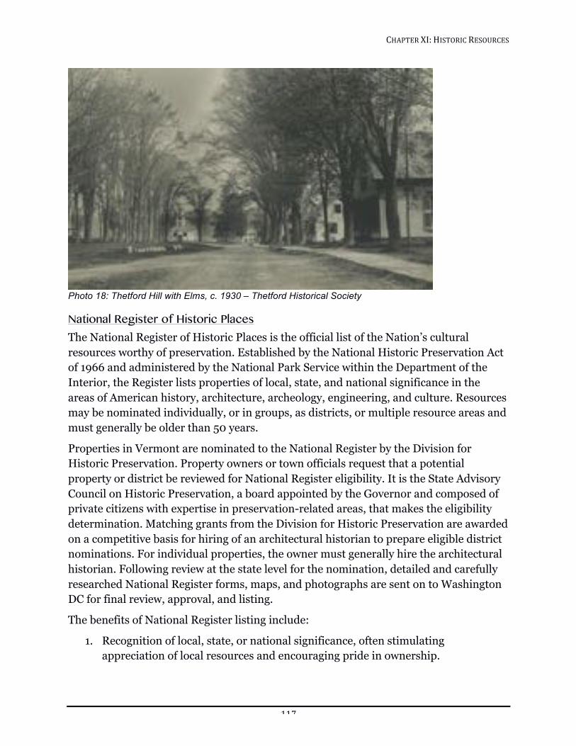
CHAPTER!XI:!HISTORIC!RESOURCES!!
117!
!Photo 18: Thetford Hill with Elms, c. 1930 – Thetford Historical Society
National Register of Historic Places The National Register of Historic Places is the official list of the Nation’s cultural resources worthy of preservation. Established by the National Historic Preservation Act of 1966 and administered by the National Park Service within the Department of the Interior, the Register lists properties of local, state, and national significance in the areas of American history, architecture, archeology, engineering, and culture. Resources may be nominated individually, or in groups, as districts, or multiple resource areas and must generally be older than 50 years.
Properties in Vermont are nominated to the National Register by the Division for Historic Preservation. Property owners or town officials request that a potential property or district be reviewed for National Register eligibility. It is the State Advisory Council on Historic Preservation, a board appointed by the Governor and composed of private citizens with expertise in preservation-related areas, that makes the eligibility determination. Matching grants from the Division for Historic Preservation are awarded on a competitive basis for hiring of an architectural historian to prepare eligible district nominations. For individual properties, the owner must generally hire the architectural historian. Following review at the state level for the nomination, detailed and carefully researched National Register forms, maps, and photographs are sent on to Washington DC for final review, approval, and listing.
The benefits of National Register listing include:
1. Recognition of local, state, or national significance, often stimulating appreciation of local resources and encouraging pride in ownership.
CHAPTER!XI:!HISTORIC!RESOURCES!!
118!
2. Provision for review and amelioration of effects that any federally funded, licensed, or assisted project might have on the property.
3. Qualification for federal and state preservation grants when funding is available. Once nominated, a National Register District must have the approval of a majority of property owners, with each owner having a single vote regardless of the number of eligible properties he may own and regardless of whether the property contributes to the district’s significance. For a single privately owned property with one owner, the property will not be listed if the owner objects. Listing in the National Register does not interfere with a property owner’s right to alter, manage, dispose of, or even demolish his property unless federal funds are involved. Nor does National Register listing require that an owner open his property to the public. Within the town, the Thetford Town Hall, the Thetford Center covered bridge (Sayers Bridge), the Union Village covered bridge, Peabody Library, the Post Mills Church, Thetford Center Historic District, and the 35-structure Thetford Hill Historic District are currently listed on the National Register.
National Register listing can be an important tool for identifying and planning the future of significant resources. Listing can act as a catalyst to change public perception and improve an area’s image, but cannot in itself prevent major detrimental alterations or even demolition. It remains an important psychological first step toward historic awareness, respect, and protection.
Local Historic Districts, Design Control Districts, & Transferable Development Rights In Vermont, as authorized by the "Vermont Townscape Preservation Act" of 1985, any municipality may adopt zoning regulations including provisions for the establishment of design control districts, historic districts and landmarks (individual structures worthy of preservation). These mechanisms are currently the most comprehensive preservation tools available to local governments to protect historic resources.
The enabling legislation empowers the planning commission to establish design control and historic districts following preparation of a report describing the particular planning and design problems of the district and setting forth a plan for the areas. A design control district can be created for any area containing structures of historical and architectural merit. In the absence of specific historic district legislation prior to 1985, several Vermont communities, including Montpelier, Woodstock, Manchester, and Hartland, applied the design control district concept to protect areas of historical significance. A design review board may be appointed by the legislative body of the municipality to advise the planning commission. Unfortunately, the effectiveness of
CHAPTER!XI:!HISTORIC!RESOURCES!!
119!
such a board is often diminished by its strict advisory role in respect to the planning commission.
As in design control districts, within an historic district no structure may be rehabilitated, substantially altered, restored, moved, demolished or changed and no new structure within an historic district may be erected, without the approval of the plans by the planning commission. A local historic district has been created on Thetford Hill to protect the architectural integrity of the village. The boundaries of this district coincide with those of the National Register Historic District. Proposals to build new structures or modify the exterior of or demolish an existing structure within the district are reviewed by the Thetford Historic Preservation Committee. Guidelines for the review are set forth in the Zoning Bylaw.
An important concept also included in the historic district legislation is the transfer of development rights. This concept addresses the importance of maintaining certain areas important to a community’s character, such as open space, despite the fact that existing structures and lands often have a development potential far beyond their current use. In response, owners of land may sell their right to develop open space or residential parcels to others wishing to develop land in other more appropriate sections of the community. By purchasing the development rights, a developer is allowed to construct a development at a higher density than would be possible if he did not possess these transferable development rights. The result is higher density in a "receiving area" and lower density in the area from which the development rights were sold. Although the concept is complex, it holds much promise for the preservation of cultural resources and open space.
Revolving Funds Revolving funds are self-replenishing loan pools. The money in the pools is composed mostly of donations and is used to restore buildings. The fund revolves when the restored building is sold. With a revolving fund, a nonprofit organization can acquire a deteriorating building, restore it and then sell it or make low interest loans available to those who need to restore their historic buildings.
The first building restored by a revolving fund should be a highly visible one, so that donors can see their money at work. A building should be endangered, well worth saving and have a high resale potential before it should be considered eligible for a revolving fund. Besides donations, an organization administering a revolving fund can solicit sources of revenue from private foundations and government subsidies such as Community Development Block Grants.
CHAPTER!XI:!HISTORIC!RESOURCES!!
120!
Easements Across the country, preservation easements have proven to be an effective tool for protecting significant historic properties. An easement is a property right that can be bought or sold through a legal agreement between a property owner and an organization eligible to hold easements. In Vermont, the Preservation Trust, Division for Historic Preservation, and local organizations are all eligible to receive easement donations. Property owners have found that easements provide them with two important benefits. First, the character of a property is protected in perpetuity. In addition, the donation of an easement may make the owner eligible for certain tax advantages. If the property is listed in the National Register, in return for giving an easement, a property owner is eligible under the Tax Treatment and Extension Act of 1980 to make a deduction from his taxes. If the easement is considered a lifetime gift, then the property owner could receive a deduction for up to 50 percent of his adjusted gross income. Donation of an easement may also reduce estate and local property taxes.
Costs of such a program may be significantly lower than buying properties outright to protect these valuable resources, particularly when easements can be acquired by donation. Significant historic resources remain in private hands but are protected from inappropriate alteration as the organization holding the easement is given the right to review any proposed changes to the structure.
Two major types of preservation easements have been employed in the past. First of all the property owner could donate an exterior facade easement. This could include air rights, exterior maintenance, alterations, etc. The second type of preservation easement is rarely used for it is difficult to enforce and also to acquire. An interior easement can restrict all or part of the interior. The facade of and open fields surrounding the Asa Burton homestead are protected by a conservation easement held by the Upper Valley Land Trust, Inc.
On a single village street, it is important to maintain open space between buildings to provide country vistas. The pleasant open vistas viewed from the Thetford Center Covered Bridge are a good example.
In rural areas, conservation easements can play a vital role in preserving the lands around historic sites. Typically, a conservation easement can be donated to protect open spaces, scenic areas, waterways, wildlife, and farmland.
Land trusts with both historic preservation and conservation interests are instrumental in safeguarding both natural and architectural features. Harrisville, New Hampshire, is an example of one rural community that has established a program to protect both settings and buildings. If properly administered, easements are a superior method of conserving and protecting land, water, and historic resources because they are permanent and therefore last longer than zoning or locally designated historic districts.
CHAPTER!XI:!HISTORIC!RESOURCES!!
121!
Covenants A covenant is a contractual agreement whereby the owner agrees to maintain the historic and architectural character of his home. A covenant can either be in the form of an affirmative provision or a negative provision. An affirmative provision requires the owner of an historic structure to provide for certain upkeep of the exterior appearance of his home. A negative provision, or a restrictive covenant, contracts the owner to abstain from changes to his historic building that would alter its historic or architectural integrity. The right to enforce a covenant is normally granted to a preservation agency. The general difference between easements and covenants is that easements are considered to be an interest in real estate, whereas covenants are only a contractual obligation. Under certain circumstances, however, covenants become binding upon future owners as well, thus blurring the difference between the two.
State Grants Limited grants are sometimes available from the Department of Historic Preservation, National Life Building, Drawer 20, Montpelier, VT 05620-0501.
Technical assistance and small grants for project organization may also be available from the Preservation Trust of Vermont, PO Box 177, Windsor House, Windsor. Foundation funding should also be explored for worthy projects.
Potential Archeological Areas Areas with proximity to water, such as the Connecticut and Ompompanoosuc Rivers and smaller brooks in the case of Thetford, logically hold great potential for prehistoric and historic archeological areas. Historically these water bodies were lined with mills seeking to harness their waterpower. Throughout town, cellar holes bear silent witness to early settlers; their houses abandoned as the families moved downhill or in other cases were destroyed by fire. Investigation of these areas, as well as the dock sites that once lined the bank of the Connecticut River and prehistoric sites, could yield much useful information relating to the lifestyles of Thetford’s early settlers. The record of these ancient times is fragile and, no doubt, much has already been lost through vandalism, builders, farmers, road construction, and the inherent acidic nature of waterfront soils. Since this report clearly deals primarily with the town’s architecture, investigation by qualified archeologists is necessary to determine the actual potential of these areas. No comprehensive survey of Thetford’s archeological resources has been prepared thus far. For more information, contact the State Archeologist at the Vermont Division for Historic Preservation.
CHAPTER!XI:!HISTORIC!RESOURCES!!
122!
GOALS, POLICIES, AND RECOMMENDATIONS Goal
Protect existing historic structures and the environment in which they are situated, while balancing preservation with energy efficiency and providing for the needs of residents.
Policies
1. Preserve, rehabilitate, and reuse historic structures.
2. Increase awareness of historic documents, artifacts, and environments.
3. Celebrate Thetford’s history and architecture through publication, and education.
Recommendations
1. The Town should catalog and preserve historic documents, and artifacts.
2. The Town should develop methods to alert landowners to historic resources on their properties so that those resources are not inadvertently destroyed.
3. The Town should encourage the use of publicly owned historic buildings either for community activities or privately, as long as their appearance is not altered significantly.
4. The Town should develop incentives to encourage landowners to preserve historic resources.
5. The Town should continue to inventory and document historic buildings, and other historic sites.
6. The Town should update and add to existing historic records.
7. The Town should support continued protection of Thetford Hill Historic District.
8. The Town should explore utilization of easements to allow access to historic parts of the community.
9. The Town should review Policies for Preservation of documents and update as necessary.
10. The Town should explore the possibility of adding three sites to the National Register of Historic Places.
a. Childhood home of Henry Wells (of Wells Fargo) off Miller Pond Road
b. Burton House off Route 113
c. Old Clay Barn on Clay Road (home of Edward Clay)
CHAPTER!XI:!HISTORIC!RESOURCES!!
123!
11. The Town should support the development or improvement of the following vehicles for increasing interest in all things historic.
a. Photographs and murals in public and commercial buildings
b. Markers at key historic structure
c. Brochures describing town history
d. Tours including walking tours with written and audio guides, of historic structures and sites
e. Classes and entire courses, both existing and new, on local history integrated into the curriculum at the elementary and secondary level
f. Oral history projects
g. Historic Thetford Quests as part of the Valley Quest Project (a project of Vital Communities http://www.vitalcommunities.org/valleyquest/index.cfm)
h. Literature in the Town Offices and website regarding appropriate rehabilitation techniques that encourage the renovation of older homes and buildings
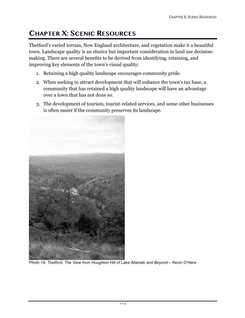
CHAPTER!X:!SCENIC!RESOURCES!!
124!
CHAPTER X: SCENIC RESOURCES Thetford’s varied terrain, New England architecture, and vegetation make it a beautiful town. Landscape quality is an elusive but important consideration in land use decision-making. There are several benefits to be derived from identifying, retaining, and improving key elements of the town’s visual quality:
1. Retaining a high quality landscape encourages community pride.
2. When seeking to attract development that will enhance the town’s tax base, a community that has retained a high quality landscape will have an advantage over a town that has not done so.
3. The development of tourism, tourist-related services, and some other businesses is often easier if the community preserves its landscape.
!Photo 19: Thetford, The View from Houghton Hill of Lake Abenaki and Beyond – Kevin O’Hara
CHAPTER!X:!SCENIC!RESOURCES!!
125!
EXISTING CONDITIONS Entranceways—the sequence of views as one arrives into or departs from Thetford’s village areas—are critically important to the visual quality of the town. Entranceways are where first impressions of a place are formed, and they are often the visual character nonresidents associate with the town. In the Land Use chapter, it has been proposed that the size of the village residential district at Thetford Hill be reduced in order both to protect the area around the Interstate 91 interchange—an important entranceway to our town—from the kind of commercial development found around many interstate exits and to support existing businesses in our village centers.
Views to the wooded hillsides and natural skyline add to the historic character of Thetford’s villages and the rural character of the roads in town.
Academy Road has been designated as a Town Scenic Road, because of its panoramic views looking east and the significant amount of open farmland. Route 5 has been designated a state and federal Scenic Byway, as part of the Connecticut River Scenic Byway (http://www.vermont-byways.us).
THE FUTURE Landscapes that take centuries to develop can be changed in an afternoon. Scenic views—ridgelines, pastures, village centers, and the surrounding hillsides—paint the picture we see in our mind’s eye when we think about what it is we love about our town. Conventional land use regulations alone cannot control the threats to the scenic resources of the region. One alternative approach has been to adopt a design control district on Thetford Hill. Other measures, described below, could involve siting, buffers, and/or architectural review, rather than outright denial of development proposals.
Design Considerations Given the importance of scenic resources in the town for environmental, economic, and quality of life reasons, the Planning Commission should be an advocate for review of development to determine the impact on visual resources and for use of techniques to mitigate any adverse impact on statewide, regional, or local scenic resources. The Planning Commission recommends that the design considerations developed by the Vermont Agency of Natural Resources Design Issues Study Committee in 1990 be used in evaluating local development proposals. This document, titled Vermont’s Scenic Landscapes: a Guide for Growth and Protection, suggests constructive responses to the issue of development in scenic areas.
Scenic Road Designations Designation of scenic roads enables a town to preserve the rural environs around its historic structures. A scenic road designation also stimulates pride in, and respect for,
CHAPTER!X:!SCENIC!RESOURCES!!
126!
the existing landscape. This is an especially important tool for Thetford’s rural areas, where the bond between architecture and landscape is inseparable.
The Vermont Legislature in 1977 enacted a bill "to preserve through planning the scenic quality of Vermont’s rural landscape," with a goal of combining both aesthetic and functional concerns. Through this law, town and state officials are given the authority to designate specific routes as scenic roads in order to protect their character, a character that often derives from historic structures as well as stonewalls, forests, mountains, and other natural features.
The responsibility for a scenic roads program rests primarily on local citizens and their officials. After volunteers conduct a survey of scenic features on the town’s roads, they recommend to the selectmen whether any of the roads should be officially designated as scenic. The selectmen then hold a public hearing and make the designations as described in 19 V.S.A. § 1019. Roads designated as scenic must be managed according to standards set by the State Transportation Board. These standards will help towns reconstruct and maintain their roads in a way that will preserve scenic quality without reducing the level of service or safety. Only state or town owned roads may be officially designated.
Ridgeline Development Controls The hills of Thetford are a key element to the aesthetic environment for much of town. Views from locations such as our village centers, rivers, hilltops, designated scenic roads, and Interstate 91 have nearly universal appeal as scenic resources. For this reason, the town should be involved in a proactive manner in protecting our hills from excessive visible development.
Minimization of Outdoor Light Pollution Dark clear skies and bright stars are a resource that contributes strongly to the rural beauty of our town. The increasing use of outdoor lighting, such as security lighting at private residences, institutions, and businesses, contributes to light pollution. This may indirectly degrade the night sky over large regions of our town by creating an overall light haze. It may also be invasive and offensive to neighbors in direct line of sight. Improperly shielded ridgeline lighting has the potential to be particularly damaging to the night viewscapes. The impact of outdoor lighting can be reduced through the use of proper shielding and screening (making sure the light is directed downward where it is needed and not up at the sky or into other residences), as well as through reduced intensity, where possible, and use only where truly necessary. Providing educational material to property owners is valuable in many situations.
In addition, the Planning Commission recommends that the Town adopt a lighting ordinance.
CHAPTER!X:!SCENIC!RESOURCES!!
127!
Competing Aesthetic, Safety and Expedience Issues Many groups have a role in our aesthetic resources. Segmentation of responsibilities is natural, but sometimes counter productive. It would be easy for only the Town Conservation Commission to deal with resources that are primarily scenic, only the Public Works Department to consider transportation resources, only the Historic Preservation Committee to consider historic aesthetics. However, it is important that we understand how closely our resources are interrelated. Whereas preservation of a fence line may be the highest priority of the Historic Preservation Committee, resulting view obstruction may seem dangerous to the Public Works Department. While widening or paving a rural road may seem expedient to the Public Works Department, it could seriously degrade the scenic quality and also cause an increase in traffic speed, making it less pedestrian friendly. In a village center, rather than enforcing minimum setbacks and making wide road shoulders for safety (common planning commission and road crew strategies in other towns), the Town might instead consider narrow roads with sidewalks and houses close to them; this is known to cause a natural slowing of traffic. Removing triangle intersections at the end of roads may make plowing easier, but it is just such features that give our town character. It is the overall aesthetic feeling of the town, not just the feeling of designated scenic roads, that is important here. The Conservation Commission, Planning Commission, Development Review Board, Selectboard, Department of Public Works, state road crews, and power company line crews could all benefit from an awareness of the tradeoffs inherent in these competing issues.
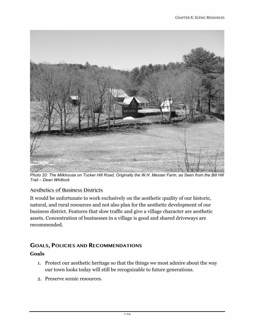
CHAPTER!X:!SCENIC!RESOURCES!!
128!
!Photo 20: The Milkhouse on Tucker Hill Road, Originally the W.H. Messer Farm, as Seen from the Bill Hill Trail – Dean Whitlock
Aesthetics of Business Districts It would be unfortunate to work exclusively on the aesthetic quality of our historic, natural, and rural resources and not also plan for the aesthetic development of our business district. Features that slow traffic and give a village character are aesthetic assets. Concentration of businesses in a village is good and shared driveways are recommended.
GOALS, POLICIES AND RECOMMENDATIONS Goals
1. Protect our aesthetic heritage so that the things we most admire about the way our town looks today will still be recognizable to future generations.
2. Preserve scenic resources.
CHAPTER!X:!SCENIC!RESOURCES!!
129!
Policies
1. Evaluate development proposals using the design considerations developed by the Vermont Agency of Natural Resources (ANR) Design Issues Study Committee in 1990. (Available in the Zoning Office.)
2. Consider visual impact in subdivision review. Developers should minimize adverse impact.
Recommendations
1. Aesthetic maintenance and improvement of town roads is a responsibility of the Department of Public Works. State road crews and power company line crews should adhere to this policy, especially for scenic roads. The Town should enhance communication between these groups.
2. The Town should consider the impact of excessive outdoor lighting on the aesthetic quality of the community and develop a lighting ordinance that will protect the view of the night sky while permitting necessary illumination.
3. The Town should encourage a village feel in our business districts and avoid strip development along Routes 5 and 113.
4. The Town should rewrite subdivision regulations to mitigate adverse impacts of development on Thetford’s aesthetic heritage.
5. The Town should minimize negative impacts of transportation projects on natural, historic, and scenic resources, as well as other community values, while also providing reasonable roadway widths, grades, sight distances, etc., developed by the Vermont Agency of Natural Resources (ANR) Design Issues Study Committee in 1990.
6. The Town should use vegetation and topography to create visual buffers between roadways and new development where appropriate.
7. The Town should use planning and new zoning to address the visual impact of any development that may threaten scenic resources. To the extent possible, the Thetford Planning Commission and Development Review Board should take an active role in site determination where scenic resources might be at risk.
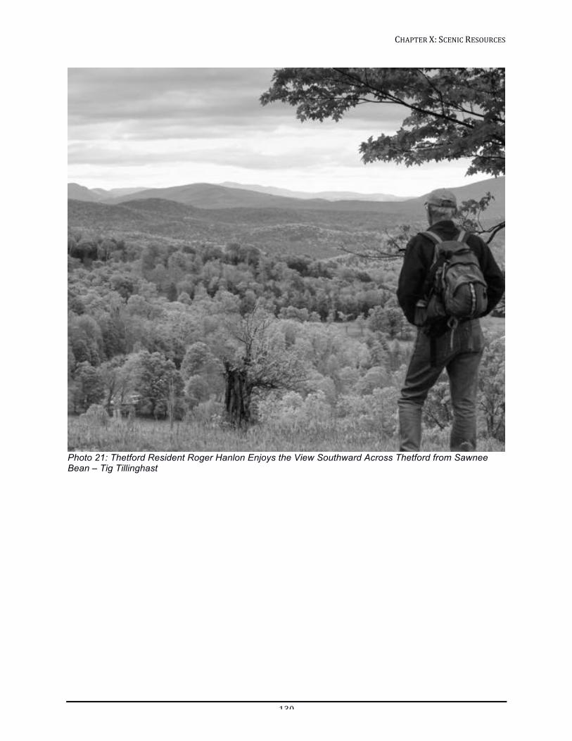
CHAPTER!X:!SCENIC!RESOURCES!!
130!
!Photo 21: Thetford Resident Roger Hanlon Enjoys the View Southward Across Thetford from Sawnee Bean – Tig Tillinghast
CHAPTER!XI:!LAND!USE!!
131!
CHAPTER XI: LAND USE The way land is used in Thetford is a result of both planned and unplanned efforts by private interests, town government, and institutions to create a pattern of living that meets the social and economic needs of the community. Existing land use patterns are the physical expression of a number of past decisions and of past failures to decide; existing patterns will in turn influence future land use. Land that can be characterized as suitable for development is a scarce resource. The use of this land should be managed wisely.
In communities facing growth pressures, there is often a struggle to maintain farmland or natural landscapes, small-town traditions, and rural character while still allowing new people and activity to join the community. Growth can bring new energy and increased resources. It can also bring traffic congestion and conflicts between the natural resources, economy, and residential lifestyles not dependent upon working lands. When the local economy struggles to stay afloat, however, the focus is more often on development strategies that will attract public and private investments.49 In Thetford, we need to balance maintaining and enhancing our natural resources and quality of life with encouraging a vibrant community in which people of all ages can thrive.
Thetford’s Town Plan is based in part on the premise that Thetford’s natural and constructed resources should be preserved and that the future development of the town should be directed and limited by the ability of the land to support that development. Thetford’s natural resources include its forests, open lands, surface and groundwater, wildlife and soils. They present both opportunities for and constraints on development, and must be conserved or used with care so as not to preclude their continued use.
Thetford’s constructed features—roads, schools, and public and private buildings—are also valuable resources that must be used wisely and maintained to ensure their usefulness. The architectural character of Thetford’s villages and historic buildings must also be protected. Maintaining the appearance of a traditional Vermont town is not only an aesthetic notion, but also a recognized economic development strategy for Vermont.50 If Thetford is to continue to provide a high quality of life for its citizens, both the natural and constructed resources of the town must be considered in future land use decisions.
49 Smart Growth in Rural Communities, International City/County Management Association, (ICMA) ©2010. 50 Middlebury 2012 Town Plan
CHAPTER!XI:!LAND!USE!!
132!
This Land Use Chapter has been developed considering:
1. Ability of the community to support development with planned capital improvement, community facilities and services
2. Diverse community attitudes toward growth and development in Thetford
3. Open space to preserve and enhance the scenic, rural and small-town qualities of Thetford
4. Existing land use and current trends in development
5. Capability of the land to support development
6. Transportation and energy efficiency
EXISTING CONDITIONS The present pattern of land use in Thetford began when Thetford’s charter was granted in 1761. People were attracted to mill sites at Thetford Center, Post Mills, Union Village, and Rices Mills as well as to the fertile land along the Connecticut River in East Thetford. The meetinghouse on Thetford Hill, built in 1787, served as another nucleus for a village. The town’s agricultural base grew, as subsistence farming gave way to sheep-raising and then to mixed farming. The pattern of dispersed residences and several village focal points continues to this day.
In 1847, the building of the Boston and Passumpsic Railroad through town strengthened the local economy by making it easier to transport local products, especially farm and mill products, to a larger market. As Thetford’s population dwindled in the latter part of the 19th century, dairy farming continued. The Chubb fishing rod factory in Post Mills and the Ely Copper Mines provided employment opportunities. Summer camps and two small hotels in Post Mills put Thetford on the map as a summer destination. Figure 19: Population of Thetford and Area Towns, 1910–2010
From 1920-1960, the population of Thetford was consistently just over 1000. At the time Interstate 91 was constructed through Thetford, the population increased dramatically in the 1960s and 1970s, about 20 years after Hanover’s population increase spiked. During this time, open fields as well as wooded areas became house lots, reinforcing the dispersed residential pattern of land use. There is continued interest in the intentional preservation of open space, and the health benefits and energy efficiency gains of walkable communities. One strategy that supports these goals would be concentrating new residences in or near the villages. It is difficult to predict whether the
0
2,000
4,000
6,000
8,000
10,000
12,000
14,000
1910 1920 1930 1940 1950 1960 1970 1980 1990 2000 2010
Thetford
Lyme
Hanover
Lebanon
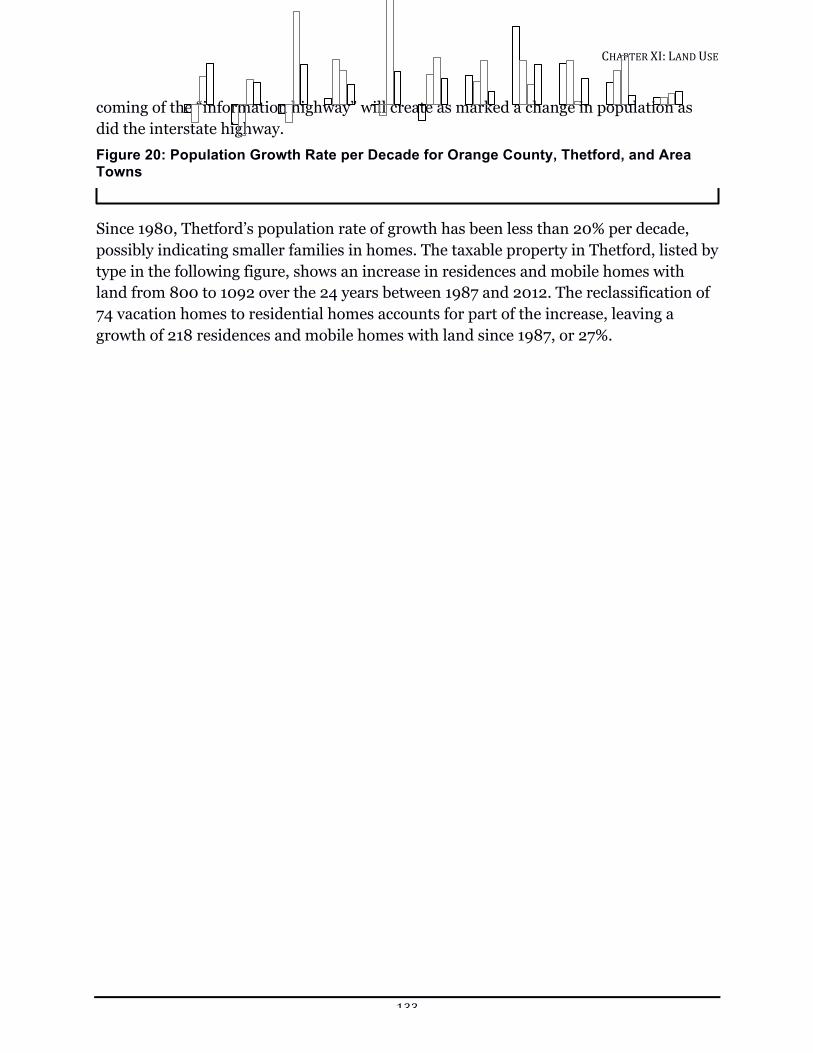
CHAPTER!XI:!LAND!USE!!
133!
coming of the “information highway” will create as marked a change in population as did the interstate highway. Figure 20: Population Growth Rate per Decade for Orange County, Thetford, and Area Towns
Since 1980, Thetford’s population rate of growth has been less than 20% per decade, possibly indicating smaller families in homes. The taxable property in Thetford, listed by type in the following figure, shows an increase in residences and mobile homes with land from 800 to 1092 over the 24 years between 1987 and 2012. The reclassification of 74 vacation homes to residential homes accounts for part of the increase, leaving a growth of 218 residences and mobile homes with land since 1987, or 27%.
620%!
0%!
20%!
40%!
60%!
80%!
100%!
1900s! 1910s! 1920s! 1930s! 1940s! 1950s! 1960s! 1970s! 1980s! 1990s! 2000s!
Percent!Population!Change!per!Decade!
Orange!County!
Lyme!
Hanover!
Lebanon!
Thetford!
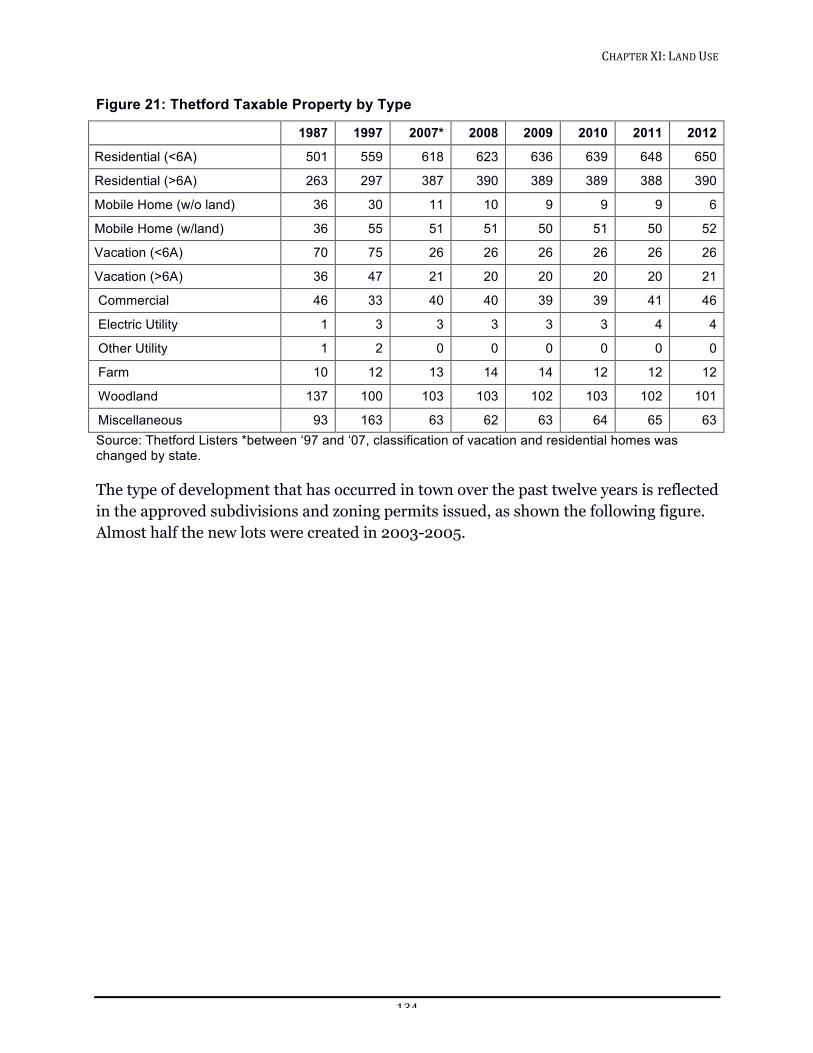
CHAPTER!XI:!LAND!USE!!
134!
Figure 21: Thetford Taxable Property by Type
1987 1997 2007* 2008 2009 2010 2011 2012
Residential (<6A) 501 559 618 623 636 639 648 650
Residential (>6A) 263 297 387 390 389 389 388 390
Mobile Home (w/o land) 36 30 11 10 9 9 9 6
Mobile Home (w/land) 36 55 51 51 50 51 50 52
Vacation (<6A) 70 75 26 26 26 26 26 26
Vacation (>6A) 36 47 21 20 20 20 20 21
Commercial 46 33 40 40 39 39 41 46
Electric Utility 1 3 3 3 3 3 4 4
Other Utility 1 2 0 0 0 0 0 0
Farm 10 12 13 14 14 12 12 12
Woodland 137 100 103 103 102 103 102 101
Miscellaneous 93 163 63 62 63 64 65 63 Source: Thetford Listers *between ‘97 and ‘07, classification of vacation and residential homes was changed by state. The type of development that has occurred in town over the past twelve years is reflected in the approved subdivisions and zoning permits issued, as shown the following figure. Almost half the new lots were created in 2003-2005.
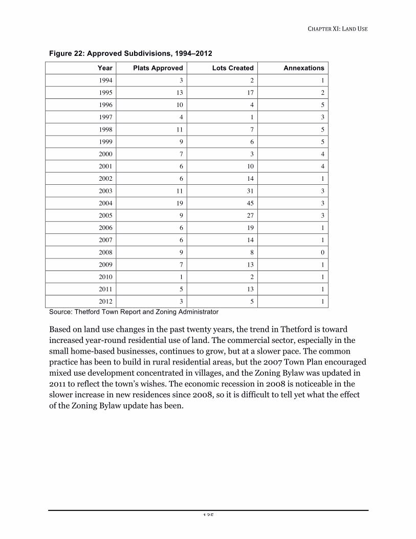
CHAPTER!XI:!LAND!USE!!
135!
Figure 22: Approved Subdivisions, 1994–2012
Year Plats Approved Lots Created Annexations
1994 3 2 1
1995 13 17 2
1996 10 4 5
1997 4 1 3
1998 11 7 5
1999 9 6 5
2000 7 3 4
2001 6 10 4
2002 6 14 1
2003 11 31 3
2004 19 45 3
2005 9 27 3
2006 6 19 1
2007 6 14 1
2008 9 8 0
2009 7 13 1
2010 1 2 1
2011 5 13 1
2012 3 5 1 Source: Thetford Town Report and Zoning Administrator Based on land use changes in the past twenty years, the trend in Thetford is toward increased year-round residential use of land. The commercial sector, especially in the small home-based businesses, continues to grow, but at a slower pace. The common practice has been to build in rural residential areas, but the 2007 Town Plan encouraged mixed use development concentrated in villages, and the Zoning Bylaw was updated in 2011 to reflect the town’s wishes. The economic recession in 2008 is noticeable in the slower increase in new residences since 2008, so it is difficult to tell yet what the effect of the Zoning Bylaw update has been.
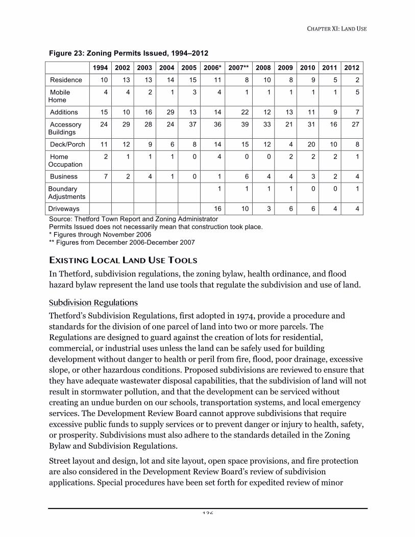
CHAPTER!XI:!LAND!USE!!
136!
Figure 23: Zoning Permits Issued, 1994–2012
1994 2002 2003 2004 2005 2006* 2007** 2008 2009 2010 2011 2012
Residence 10 13 13 14 15 11 8 10 8 9 5 2
Mobile Home
4 4 2 1 3 4 1 1 1 1 1 5
Additions 15 10 16 29 13 14 22 12 13 11 9 7
Accessory Buildings
24 29 28 24 37 36 39 33 21 31 16 27
Deck/Porch 11 12 9 6 8 14 15 12 4 20 10 8
Home Occupation
2 1 1 1 0 4 0 0 2 2 2 1
Business 7 2 4 1 0 1 6 4 4 3 2 4
Boundary Adjustments
1 1 1 1 0 0 1
Driveways 16 10 3 6 6 4 4 Source: Thetford Town Report and Zoning Administrator Permits Issued does not necessarily mean that construction took place. * Figures through November 2006 ** Figures from December 2006-December 2007
EXISTING LOCAL LAND USE TOOLS In Thetford, subdivision regulations, the zoning bylaw, health ordinance, and flood hazard bylaw represent the land use tools that regulate the subdivision and use of land.
Subdivision Regulations Thetford’s Subdivision Regulations, first adopted in 1974, provide a procedure and standards for the division of one parcel of land into two or more parcels. The Regulations are designed to guard against the creation of lots for residential, commercial, or industrial uses unless the land can be safely used for building development without danger to health or peril from fire, flood, poor drainage, excessive slope, or other hazardous conditions. Proposed subdivisions are reviewed to ensure that they have adequate wastewater disposal capabilities, that the subdivision of land will not result in stormwater pollution, and that the development can be serviced without creating an undue burden on our schools, transportation systems, and local emergency services. The Development Review Board cannot approve subdivisions that require excessive public funds to supply services or to prevent danger or injury to health, safety, or prosperity. Subdivisions must also adhere to the standards detailed in the Zoning Bylaw and Subdivision Regulations.
Street layout and design, lot and site layout, open space provisions, and fire protection are also considered in the Development Review Board’s review of subdivision applications. Special procedures have been set forth for expedited review of minor
CHAPTER!XI:!LAND!USE!!
137!
subdivisions and for flexible lot layouts for planned residential and planned unit developments. In 1991 the Planning Commission amended the Subdivision Regulations to require adequate fire protection.
In 2015, Subdivision Regulations are being updated to reflect the standards for development established in the 2011 Zoning Bylaw.
Zoning Bylaw The Thetford Zoning Bylaw, updated in 2011, guides the type and intensity of land use and the location of structures on a parcel of land. In Thetford, zoning was adopted to:
1. Protect the public health, safety, and general welfare.
2. Carry out local goals and objectives that foster orderly community development.
3. Preserve natural resources and retain the beauty and historic character of the town.
4. Ensure that property owners enjoy unhampered use of their property, provided that such use does not affect the health or safety of their neighbors or unduly impair the value of neighboring property.
5. Minimize the expense of providing essential town services.
Four types of zoning land use areas and one district overlay have been established in Thetford. The character of each of these zoning land use areas and the overlay is described briefly below; the Zoning Bylaw should be consulted for specific use and size restrictions.
VILLAGE RESIDENTIAL LAND USE AREA (VR)
The general purpose of the Village Residential land use area is to create relatively dense areas of settlement with the following characteristics:
1. Networks of streets and utilities that make efficient use of land.
2. Neighborhoods with resources such as schools, shops, and libraries within walking distance of residences.
3. Relatively dense housing, noting that village lots “grandfathered” before zoning were often smaller than the current minimum of 20,000 square feet.
4. Mixed-use development, compatible in scale and lot coverage with existing development, supporting commercial and public services for residents.
The minimum lot size in this area is 20,000 square feet, which can support one- or two-unit dwellings. The minimum lot size requirement can be waived in a Planned Unit Development.
CHAPTER!XI:!LAND!USE!!
138!
Residential uses, home businesses, accessory dwellings, churches, farmers markets, and customary accessory uses are the only permitted uses. Conditional uses include civic and institutional uses, businesses, recreational use, commercial and commercial services, cultural facilities, and restaurants.
Thetford’s village districts are Thetford Hill, Thetford Center, Post Mills, North Thetford, and Union Village. Any of these villages are eligible for Village Center designation.
COMMUNITY BUSINESS LAND USE AREA (CB)
The purpose of the Community Business land use area is to share the characteristics of the Village Residential district, with an emphasis on commercial development, compatible in scale and lot coverage with existing development, ranging from small to medium in size.
Unlike Village Residential, the Community Business area allows light industry as a conditional use and allows restaurants, bed and breakfasts, motels and hotels as permitted uses. East Thetford is currently the Town’s only Community Business land use area. It is eligible for Village Center designation.
NEIGHBORHOOD RESIDENTIAL LAND USE AREA (NR)
The purpose of the Neighborhood Residential land use area is to create relatively dense areas of settlement with the following characteristics:
1. Networks of streets and utilities that make efficient use of land.
2. Relatively dense housing, noting that village lots “grandfathered” before zoning were often smaller than the current minimum of 20,000 square feet.
3. Close proximity to Village Residential or Community Business area, where resources such as schools, shops, libraries and commercial and public services for residents can be found.
The minimum lot size in this area is 20,000 square feet, which can support one- or two-unit dwellings. The minimum lot size requirement can be waived in a Planned Unit Development.
Residential uses, home businesses, accessory dwellings, churches, farmers markets, and customary accessory uses are the only permitted uses. Conditional uses include civic and institutional uses, businesses, recreational use, cemeteries, mobile home parks, cultural facilities, restaurants, and commercial services. Village and roadside commercial, industrial, kennel, junkyard, landfill, and travel trailer camp use will not be allowed.
CHAPTER!XI:!LAND!USE!!
139!
RURAL RESIDENTIAL LAND USE AREA (RR)
The purpose of the Rural Residential land use area is to maintain an area of low average density with clusters of high-density use. The Rural Residential area should remain primarily a district of open space, farms, residences, and woodlands, with scattered uses that are either home-based or dependent on natural resources. This area is characterized by development that has:
1. Particular sensitivity to agriculture and natural resources.
2. Minimal sprawl.
The minimum lot size in Rural Residential is 80,000 square feet with exceptions for two-unit dwellings and waivers for Planned Unit Developments.
The permitted uses in Rural Residential area include all of the permitted uses in the Village Residential plus cultural uses, and cemeteries. Conditional uses are the same, excluding certain commercial use, such as hotels and motels, and expanding conditional use to include kennels, and other uses subject to special restrictions (junk yards, landfills, etc.)
This area covers the parts of town not designated as Village Residential, Neighborhood Residential, or Community Business Land Use Areas.
THETFORD HILL HISTORIC PRESERVATION OVERLAY DISTRICT
The purpose of the Thetford Hill Historic Preservation Overlay District is to ensure the protection, enhancement, and renovation of significant architectural and historic resources in Thetford Hill. This area shall preserve property, districts, buildings, and sites having special historical associations or significance or of special architectural merit or significance. While not all buildings are of equal historic significance, all buildings and lands support and contribute to any given area. All uses in the Thetford Hill Historic Preservation Overlay District are conditional use.
Flood Hazard Area Zoning Bylaw This bylaw was adopted in 1978 and updated in July 2008 to promote public health, safety, and general welfare.51 The purpose, according to Article II of the bylaw, is to ensure all of the following:
1. Minimize and prevent the loss of life and property, the disruption of commerce, the impairment of the tax base, and the extraordinary public expenditures and
51 http://www.thetfordvermont.us/wp/wp-content/uploads/2011/05/Flood-Hazard-Area-Zoning-Bylaw-2008.pdf
CHAPTER!XI:!LAND!USE!!
140!
demands on public services that result from flooding and other flood related hazards.
2. Ensure that the design and construction of development in flood and other hazard areas are accomplished in a manner that minimizes or eliminates the potential for flood and loss or damage to life and property.
3. Manage all flood hazard areas designated pursuant to 10 V.S.A. § 753.
4. Make the state, municipalities, and individuals eligible for federal flood insurance and other federal disaster recovery and hazard mitigation funds as may be available.
According to Article III of the bylaw, it applies to: “…all)areas)in)the)Town)of)Thetford,)Vermont)identified)as)areas)of)special)flood)hazard)in)and)on)the)most)current)flood)insurance)studies)and)maps)published)by)the)Department)of)Homeland)Security)(DHS),)Federal)Emergency)Management)Agency)(FEMA),)National)Flood)Insurance)Program)(NFIP),)as)provided)by)the)Secretary)of)the)Agency)of)Natural)Resources)pursuant)to)10)V.S.A.)§)753,)which)are)hereby)adopted)by)reference)and)declared)to)be)part)of)this)bylaw.”)
New construction in affected areas requires a permit. With certain exceptions, all new structures are prohibited. Open space uses are defined and permitted. Improvement and maintenance to existing structures are conditional uses requiring Development Review Board approval. The bylaw specifies development standards for the floodway and floodway fringe area.
The bylaw describes the permitting process and defines the specialized terms utilized within the bylaw.
THE FUTURE
Land Capability The fundamental premise of the concept of land capability is that the natural features of the environment vary in their ability to support development. Steep slopes, flood-prone areas, wetland soils, agricultural lands, wildlife habitat, forest resources, and the presence of bedrock at or near the surface, are constraints to development. The capacity to treat sewage effluent properly on a site is a key consideration since there are currently no municipal sewer areas in Thetford.
Sewer lines can overcome a number of the limitations, however, natural factors remain an important consideration for road construction, foundation stability, erosion and sedimentation hazards. Slope, soil type, and depth to bedrock affect the cost of constructing and maintaining sewer lines.
CHAPTER!XI:!LAND!USE!!
141!
Soil characteristics of critical natural resources may steer development away from most of these areas. Special guidelines may be necessary to limit development on agricultural and aquifer recharge soils.
The future land use vision for Thetford has three components: 1) a natural resource and open space protection plan, 2) a residential plan, and 3) a plan for accommodating businesses. The vision is based on the premise that Thetford’s natural resources should be preserved and that the future development of the town should be directed and limited by the ability of the land to support that development. Our current zoning districts include rural residential, community business, and village residential. In the future, an additional zoning district may be created to facilitate centralizing commercial activity. This plan recognizes the need for defined standards to protect special areas such as significant wildlife habitat and agricultural land.
Natural Resource and Open Space Protection Thetford’s natural resources are described in the Natural Resources chapter. The presence of these elements in the town and their relatively unspoiled condition are important to the people of Thetford. Respondents to the 1992 survey, the 1997 Thetford profile, the 2010 Village Visioning Forum, and participants in the Town Plan Open Houses in 2011-2012 favored continuity for environmentally sensitive areas and, in addition, did not want development in areas where it is difficult to provide public services.
Thetford’s land use tools provide limited protection from development in environmentally sensitive areas. State land use regulations have minimal impact because a great deal of development in Thetford does not require state review. Action and enforcement, where applicable, function best at the local level and should rely on standards set for development review. The review process should encourage discussion on how to meet development goals in accordance with the town’s overarching priorities.
Residential Development If there is growth in Thetford, residences are likely to continue to be the predominant form of development. New residences will affect the need for community facilities and services and place additional demands on the town’s natural resources.
To minimize the loss of Thetford’s farmland, fields and forests, a variety of residential development options must be provided including denser development that preserves open space and provides access to services. Thetford must plan for both sparsely and closely settled areas to minimize sprawl, preserve open space and privacy, and offer neighborhood living with the associated benefits and services.
CHAPTER!XI:!LAND!USE!!
142!
Zoning Districts We have four villages that are zoned as village residential land use areas (VR) and one village (East Thetford) that is zoned as a community business land use area (CB). Any of these five villages can qualify for Village Center designation (see Chapter III, Future Economic Development). Bordering the Post Mills village area along Route 113 to the north and Route 244 to the east is a neighborhood residential area. Currently, this is the only neighborhood residential area in the town. Two of the purposes of such an area on a village periphery along major roads are to restrict commercial development to the village center and to discourage sprawl outward while maintaining the closer residential settlement characteristic of a village. In the Post Mills case, the boundaries of the area were established with due respect to prominent village features such as the airport and church and after hearing the opinions of residents about the effective limits of the town center.
Energy Energy independence and clean energy sources for the future are tied to the town’s natural resources and business climate. How we choose to use our land affects the energy use of the town. Siting of residences and businesses has a great effect on the possibilities for efficient heating and transportation. Thetford should remain open to new types of energy, such as wood pellets and biomass, as ways to use local renewable natural resources in agriculture and silviculture that can build a better energy future and contribute to Thetford’s economy. See the Energy chapter for further exploration of possibilities.
GOALS, POLICIES AND RECOMMENDATIONS Goals
1. Conserve Thetford’s natural heritage. (See the Natural Resources chapter.)
2. Preserve the rural character of Thetford and strengthen the identity of Thetford’s villages. (See the Future Economic Growth chapter.)
3. Promote a small town quality and character in housing development to preserve and enliven Thetford’s villages.
4. Encourage an inter-generational population, with housing, education, activities, and employment opportunities for a wide range of ages. (See also Future Economic Growth chapter.)
Policies
1. Development review standards guide policy for preservation of rural and village character and natural resources.
CHAPTER!XI:!LAND!USE!!
143!
2. Encourage mixed-use, higher-density development, which includes walkable neighborhoods, universal design and active lifestyle elements, energy efficiency, and protection of natural resources.
3. Ensure project developers and owners meet or exceed state mandated standards for energy performance of construction.52
Recommendations
1. The Town should work with the Connecticut River Joint Commission to protect the river’s water quality and shoreline, and to provide recreational access to the river.
2. The Town should promote the use of conservation easements (and purchase of development rights) to protect natural resources and open space (i.e., with Vermont Land Trust or Upper Valley Land Trust).
3. The Conservation Commission should continue to assemble information about Thetford’s natural resources and this information should be used in development reviews.
4. The Town should maintain but not improve or create roads that open up currently inaccessible parts of the town.
5. The Town should encourage development in Thetford’s village areas to be sensitive to the visual aesthetic of the traditional Vermont town.
52 Commercial Building Energy Standards: 21 V.S.A. §268. Residential Building Energy Standards 21 V.S.A. section §266.
CHAPTER!XII:!RELATIONSHIP!OF!THIS!PLAN!TO!THE!REGION!!
144!
CHAPTER XII: RELATIONSHIP OF THIS PLAN TO THE REGION An important premise behind planning is the necessity of looking beyond a single community’s borders, both to coordinate and complement and to mitigate any negative influence of growth and development among neighboring communities.
Thetford is a member of the Two Rivers-Ottauquechee Regional Commission (TRORC) and shares borders with five towns: West Fairlee, Fairlee, Norwich, Sharon, and Strafford. Based on a review of the six plans listed below, the Thetford Plan is both consistent with and compatible with the plans of the adjacent towns and the region. Thetford also maintains membership in the Greater Upper Valley Solid Waste District.
Based on a review of current and proposed land use goals and objectives, as well as this plan’s relationship to neighboring town plans, there is no conflict with the Thetford Town Plan in the following town plans:
1. The Norwich Town Plan, adopted June 2011. 2. The Sharon Municipal Plan, adopted March 2005. 3. The Strafford Town Plan, adopted January 2011. 4. The West Fairlee Town Plan, adopted August 2012.
There is a potential conflict with the Fairlee Town Plan, adopted September 2014.
At present, Fairlee has a designated Industrial Area located around Route 5 in the area bordering Thetford. It is possible that development allowed in Fairlee’s Industrial Area might conflict with the Rural Residential zoning that Thetford has designated for that area.
The current and proposed land use sections of the Strafford Town Plan and map show floodplain areas that extend to the Thetford town line. The future land use sections of the West Fairlee Town Plan and maps show a conservation district, low and medium density rural districts, a shoreland district, and floodplain areas abutting the Thetford town line. Future development in Thetford, where it abuts Strafford and West Fairlee, should take these neighboring districts and related policies into account.
The town of Lyme, New Hampshire lies on our eastern border, across the Connecticut River. Although Lyme is not in the state of Vermont and is not a part of our regional planning group of towns, it exerts an important influence on Thetford. Lyme residents pass through East Thetford en route to Interstate 91 or to work in Thetford and points beyond. Lyme also sends some of its students to Thetford Academy. Some Thetford residents find employment in Lyme or pass through it on their way to work. Some shop, eat or participate in social functions in Lyme and many residents, especially in North Thetford, long for the days when the old North Thetford-Lyme bridge connected our
CHAPTER!XII:!RELATIONSHIP!OF!THIS!PLAN!TO!THE!REGION!!
145!
New Hampshire neighbors more closely to that village than to the people in most other parts of Thetford.
Two Rivers-Ottauquechee Regional Plan, adopted June 2012, was reviewed for consistency with Thetford’s proposed Town Plan, particularly land use goals and policies, and plan implementation. TRORC has recommended that the Thetford Town Plan of 2007, readopted in 2012, be revised in a number of places in order to bring it into conformance with the required elements listed in 24 V.S.A. § 4382 and to make it consistent with the Regional Plan. These recommendations have been taken into account in this current plan.
CHAPTER!XIII:!IMPLEMENTATION!OF!THE!PLAN!!
146!
CHAPTER XIII: IMPLEMENTATION OF THE PLAN The goals, policies, and recommendations of this plan lay a foundation for the future development of Thetford. This Town Plan will be effective for five years from the date of adoption (24 V.S.A. § 4387) unless replaced earlier. During that time, the Town may move to implement the goals of the plan and the related policies and recommendations through several regulatory and non-regulatory tools including, but not limited to, those listed here. (See 24 V.S.A. § 4401- 4403 for a complete list.)
REGULATORY APPROACHES TO IMPLEMENTATION 1. Zoning Regulations: Zoning is a legal process designed to protect the health,
safety, and welfare of a community by control of the use of land. A municipality may adopt zoning regulations to permit, prohibit, restrict, and determine land development.
2. Subdivision Regulations: Subdivision regulations set forth the procedures, requirements, and specifications for the division of land into two or more parcels. Such things as design of streets and lots, installation of utilities, and reservation of park or school land are normally contained in a subdivision bylaw. Thetford is currently in the process of re-writing the Subdivision Regulations in order to bring them into compliance with state law.
As soon as a plan has been adopted, the Planning Commission can propose changes that keep the town in compliance with state law and which carry out the intent of the plan. Adoption or amendment of these bylaws requires at least two public hearing and approval by a majority of the members of the Selectboard (24 V.S.A. §4442).
ACT 250 Vermont towns may provide input into the state’s regulation of land development through Act 250, Vermont’s Land Use and Development Law (10 V.S.A. Ch. 151). By law, the Selectboard and the Planning Commission have full party status in all Act 250 proceedings involving Thetford; they may testify on each of the criteria, offer witnesses to present evidence, and appeal decisions with which they disagree.
The Vermont legislature passed Act 250 to address concerns that arose after the opening of Interstates 91 and 89. The interstates made access to the state much easier for year-round visitors, creating community concerns about congestion, increased environmental problems, the burden of development on local services, and rising taxes. There were no environmental regulations or land use controls in existence at the time. The law created nine District Environmental Commissions to review large-scale development projects using ten criteria that are designed to safeguard the environment, community life, and the aesthetic character of the state. Act 250 also created the
CHAPTER!XIII:!IMPLEMENTATION!OF!THE!PLAN!!
147!
Vermont Environmental Board to review appeals coming from District Environmental Commission rulings. District Environmental Commissions have the power to issue or deny a permit to real estate developers for any project that encompasses more than 10 acres, or more than 1 acre for towns that do not have permanent zoning and subdivision bylaws. The law applies to any development project with more than 10 housing units or housing lots, and may also apply for construction proposed above 2,500 feet of elevation.
For more information about Act 250, consult the Vermont Agency of Natural Resources web site http://www.anr.state.vt.us/dec/permit_hb/sheet47.pdf.
This Plan provides a standard for local review and comment on Act 250 applications. In a broad sense, it establishes a basis for town testimony on the first nine criteria relating to specific subject areas. Specifically under criterion 10, a proposed project must be found to be in conformance with the Plan before a Land Use Permit can be issued. In this manner, the Plan has the potential to become a major factor in the regulations of land development that falls under the jurisdiction of Act 250.
NON-REGULATORY APPROACHES TO IMPLEMENTATION Implementation of the Plan requires public involvement and coordination between the various interest groups in the community.
Private initiatives and non-regulatory approaches to land use such as tax stabilization agreements, land purchase, conservation easements, and gifts of land can supplement regulation. Such efforts may be supported by groups like Thetford’s Conservation Commission, Energy Committee, and Historical Society as well as private non-profit organizations such as conservation foundations, historical societies, land trusts, and watershed associations.
CONTINUING THE PLANNING PROCESS The Planning Commission has the primary responsibility for maintaining and updating the Town Plan. This process will start well before the five-year period has lapsed and will include significant input from the citizens of Thetford.
Education on the value of community planning needs to continue. This will be accomplished through a variety of means including newsletters, community forums and media announcements.
The Planning Commission meets at 7:15pm on the first and third Tuesdays of the month at the Town Hall. The Planning Commission welcomes your input and a public comment period is scheduled at the beginning of each meeting. Written comments are also welcome and may be submitted to any member of the Planning Commission.