
VALLEY PARK, DIDCOT - IEMA - Home_Didcot_NTS... · VALLEY PARK, DIDCOT Non-Technical Summary...
34
VALLEY PARK, DIDCOT Non-Technical Summary December 2014 On behalf of Taylor Wimpey UK Limited, Persimmon Homes and Hallam Land Management Ltd.
Transcript of VALLEY PARK, DIDCOT - IEMA - Home_Didcot_NTS... · VALLEY PARK, DIDCOT Non-Technical Summary...
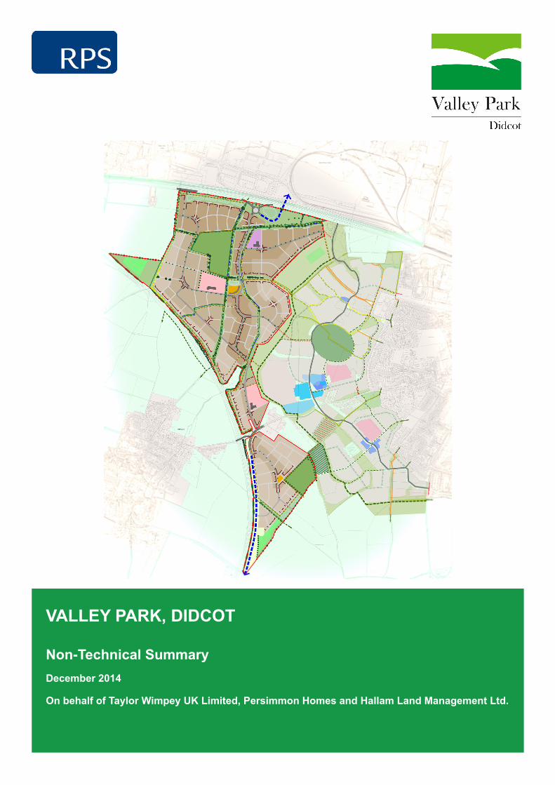
VALLEY PARK, DIDCOT
Non-Technical SummaryDecember 2014
On behalf of Taylor Wimpey UK Limited, Persimmon Homes and Hallam Land Management Ltd.

Non-Technical Summary
1
CONTENTS
1 Introduction ................................................................................................................................. 2
2 The Proposed Development ...................................................................................................... 4
3 Need and Alternatives Considered .......................................................................................... 12
4 Consultation, Scope of Assessment and Methodology ............................................................ 14
5 Summary of Environmental Effects .......................................................................................... 17
6 Further Information ................................................................................................................... 33
Non-Technical Summary
2
1 Introduction
1.1 Taylor Wimpey UK Limited, Persimmon Homes and Hallam Management Limited (‘the
Applicants’) propose new residential development on land adjacent to Great Western Park, to
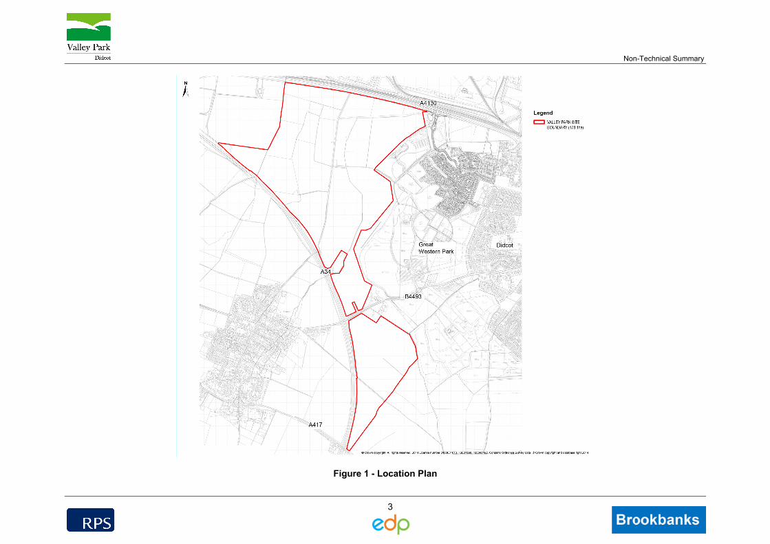
the west of Didcot, Oxfordshire (Figure 1).
1.2 The development, known as Valley Park, comprises up to 4,450 new dwellings, together with
community and educational facilities, landscape planting, open space and access.
1.3 A process of Environmental Impact Assessment (EIA) has been undertaken in accordance
with UK legal requirements to identify the likely significant environmental effects of the
proposed development. An Environmental Statement has been produced, setting out the
findings of the assessment process. The Environmental Statement supports the planning
application to the local planning authority, the Vale of White Horse District Council.
1.4 This document is the Non-Technical Summary of the Environmental Statement. This
summary document provides an overview of the assessment findings. Details of how to view
the full Environmental Statement or to obtain further copies of this Non-Technical Summary
are provided at the end of this document.
Non-Technical Summary
3
Figure 1 - Location Plan
Non-Technical Summary
4
2 The Proposed Development
The Site and Surrounding Area
2.1 The Valley Park site is located to the west of Didcot, Oxfordshire and occupies an area of
approximately 178.1 hectares. The site is bounded to the north by the A4130, beyond which
lies the Milton Park employment area and industrial land, including the Didcot power station.
2.2 The A4130 connects to the A34 at the Milton Interchange to the north west of the Valley Park
site. The A34 provides a north-south link through Oxfordshire, providing connections to
Oxford and the M40 to the north of the site. The A34 forms the site’s southern/western
boundary.
2.3 The site is dissected by the B4493, which crosses the A34 to the west of the site and
connects the village of Harwell with Didcot. The southern section of the Valley Park site lies
between the B4493 and the A417 to the south.
2.4 The eastern boundary of the site is formed by the Great Western Park residential
development. Construction work at Great Western Park commenced in 2011 and remains
ongoing. Parts of the Great Western Park site are now completed and occupied.
Description of Development
2.5 The Valley Park project comprises a residential development with associated means of
access; educational and community facilities; landscape planting and public open space
(Figure 2). The project includes the following key components:
Residential development of up to 4,450 dwellings;
Two new primary schools and an area of land for a special needs school;
A local centre;
Public open space, including sports pitches;
Natural green space to include landscape buffer areas and semi-natural green space and
allotments;
New access from into the site from the A4130 and the B4493;
Secondary accesses and routes within the site, including a network of car, bus and
pedestrian and cycle routes connecting the local road network and to Great Western
Park; and
Sustainable drainage infrastructure.
Non-Technical Summary
5
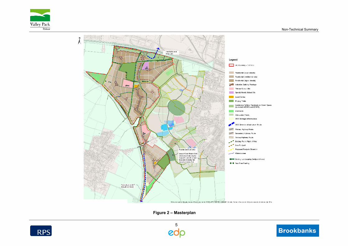
Figure 2 – Masterplan
Non-Technical Summary
6
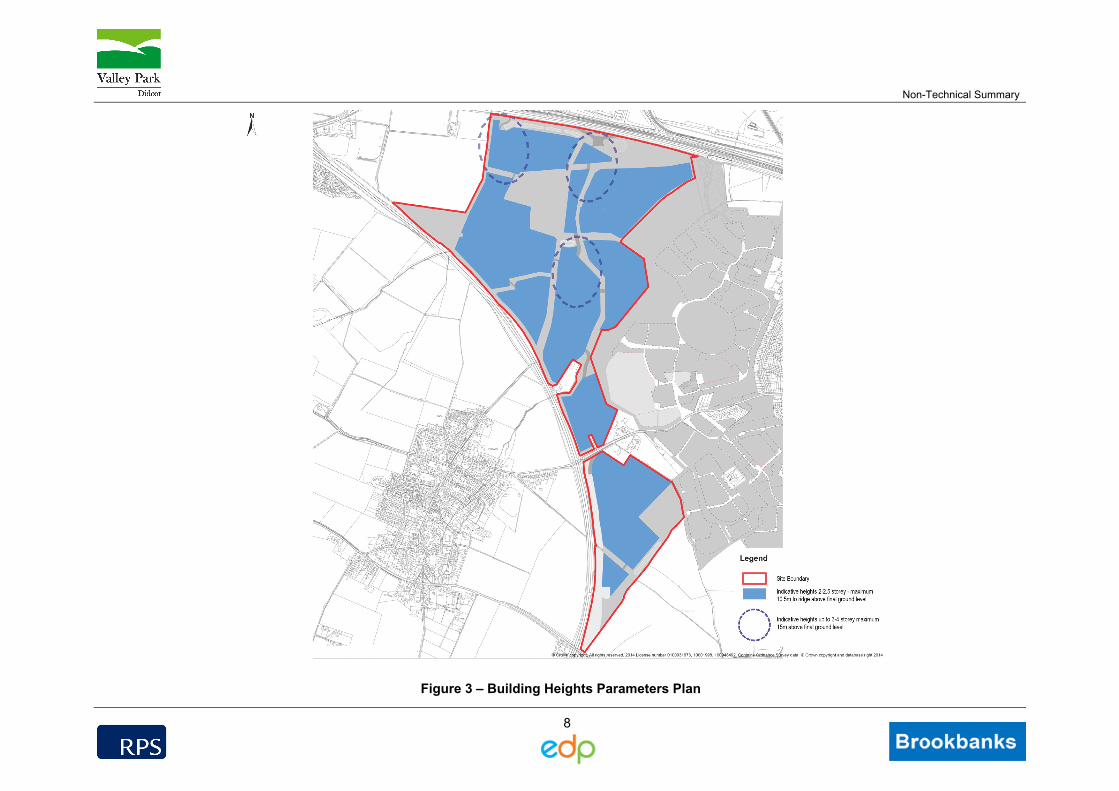
2.6 The development would include a mixture of accommodation. Building height would typically
be between two and four storeys, with height reflecting the changes in land form and
landscape sensitivity of the site (Figure 3). The average site density is anticipated to be
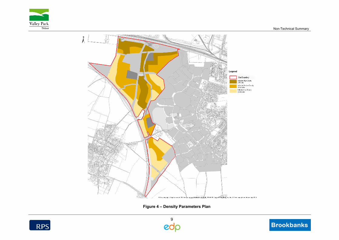
approximately 40 dwellings per hectare (Figure 4).
2.7 It is proposed that the buildings would reflect the local architecture in form, scale and material,
but with their own distinctive character and identity. It is proposed that the site would be
developed to highlight particular character areas within the site.
Local Centre
2.8 The local centre would occupy an area of approximately 0.95 hectares in size
2.9 The centre would include the following:
A neighbourhood centre to include local shops and community facilities to serve the
development;
A community centre.
Schools
2.10 Two primary schools (one ‘two form entry’ and one ‘three form entry’) would be provided. The
two form entry school would occupy an area of approximately 2.2 hectares, while the three
form entry school would occupy approximately 3 hectares.
2.11 In addition, 1.60 hectares of land is provided within the site for a special needs school.
Access
2.12 The project would be accessed from the existing highway. The main access would be from
the A4130 to the north of the site. This access would take the form of a roundabout to the
south of the A4130 (offline).
2.13 In addition, a second access from the A4130 would be provided in the north west of the site.
This would provide a T-junction access to the western part of the site. The site would also be
accessible to the north and south from the B4493.
2.14 A network of internal highway routes would provide connections throughout the site and to the
Great Western Park development to the east.
2.15 Routes for pedestrians and cyclists would be provided throughout the site, including dedicated
routes to promote sustainable travel.
2.16 A public transport strategy would be developed and agreed with the local planning authority to
ensure adequate public transport provision. The strategy would provide links to key
destinations, including Didcot town centre and the train station.
Non-Technical Summary
7
2.17 The project design also allows space for future highways improvements proposed by
Oxfordshire County Council, including:
Science Bridge – the proposed site layout at the main entrance allows for any future
proposal by Oxfordshire County Council to connect the roundabout to their proposed
Science Bridge (and for potential improvements to the A4130);
Harwell Strategic Link Road: In the southern part of the site, the project design allows
space for a connection between the B4493 and the A417 on the eastern side of the A34,
which forms part of Oxfordshire County Council’s proposed strategic link road.
Public Open Space, Landscape and Planting Strategy
2.18 Public open space and recreational facilities would be provided as part of the project. Land
allocated for playing fields and sports pitches occupies an area of 12.76 hectares. This would
be split between an area of approximately 8 hectares in the northern part of the site and an
area of approximately 4.76 hectares in the south. Sports provision has been developed in
consultation with the local planning authority and Sport England.
2.19 Approximately 3.1 hectares of land would be provided for allotments. This is split between
two areas; one located in the north western part of the site and the other in the southern part
of the site.
2.20 In addition, 32.83 hectares of semi-natural open space and landscape planting are provided
for informal recreation. As part of the landscape strategy, the project would include a number
of green corridors. These would take the form of retained and new routes through the site. It
is proposed that Cow Lane would remain in place with the existing hedgerows to be retained
and reinforced with additional planting. The route would become an all-weather route suitable
for horse riders, cyclists and pedestrians. The route would convey users through Valley Park
to key locations, including the local centre. Corridors emanating from this route would provide
access throughout the development, including access to Great Western Park. In the southern
part of the site, ‘The Driftway’ would be retained on its current alignment, although it is likely
that the road through the site would need to cross this route. The indicative masterplan
allows for an open green setting to the north and enhanced with new tree and hedgerow
planting.
2.21 The central stream corridor would be retained as a green spine through the centre of the
development. The watercourse on the western site boundary would also be retained. Both
would function as key wildlife corridors through the site.
Non-Technical Summary
8
Figure 3 – Building Heights Parameters Plan
Non-Technical Summary
9
Figure 4 – Density Parameters Plan
Non-Technical Summary
10
Construction Phase
2.22 Construction works would be undertaken in accordance with a Code of Construction Practice.
The current programme indicates a total construction period of approximately 15 years (based
on an indicative rate of 300 dwellings per year progressed in phases across the site), subject
to market conditions. Working hours are likely to be 07:00 to 19:00 hours Monday to Friday,
07:00 to 13:00 hours on Saturday and at no time on Sundays or on public or bank holidays.
These hours would be subject to agreement with the local planning authority. In the event
that works are required outside of these hours in exceptional circumstances, this would be
agreed with the local planning authority prior to commencement of the activity.
2.23 The broad sequence of construction activities is likely to be:
Construction of main site access to allow access for construction vehicles;
Setting up of working areas and earthworks/regrading of the site;
Infrastructure works, including construction of internal roads, drainage works and sewage
pumping station;
Construction of substructures;
Erection of superstructures and building finishes; and
Planting in accordance with the landscape strategy.
2.24 A number of temporary facilities would be required during construction including:
Temporary offices and welfare facilities;
Storage area for materials, fuels, plant and equipment;
Waste management areas; and
Car parking facilities.
2.25 The development site would be fenced during construction. It is the intention of the applicants
that the site would be registered under the Considerate Constructors Scheme or locally
recognised certification scheme.
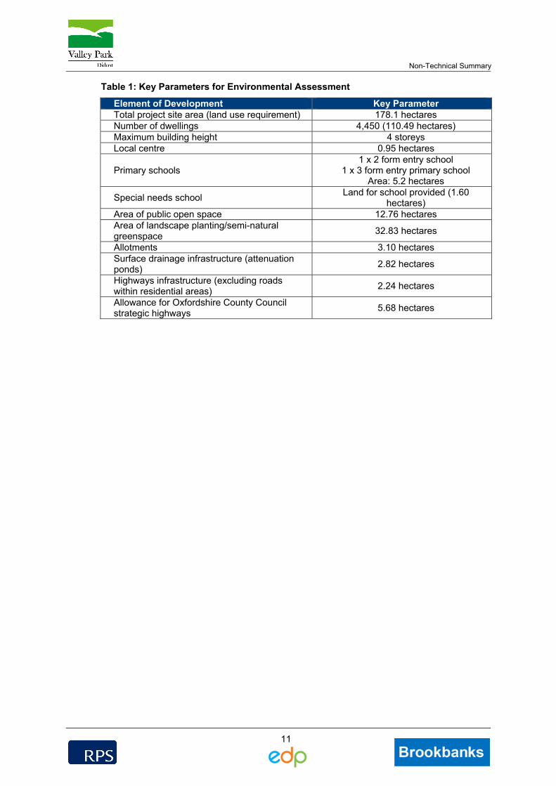
Summary of Key Parameters
2.26 The table below provides a summary of the key parameters that have formed the basis for the
assessment of effects.
Non-Technical Summary
11
Table 1: Key Parameters for Environmental Assessment
Element of Development Key Parameter Total project site area (land use requirement) 178.1 hectares Number of dwellings 4,450 (110.49 hectares) Maximum building height 4 storeys Local centre 0.95 hectares
Primary schools 1 x 2 form entry school
1 x 3 form entry primary school Area: 5.2 hectares
Special needs school Land for school provided (1.60
hectares) Area of public open space 12.76 hectares Area of landscape planting/semi-natural greenspace
32.83 hectares
Allotments 3.10 hectares Surface drainage infrastructure (attenuation ponds)
2.82 hectares
Highways infrastructure (excluding roads within residential areas)
2.24 hectares
Allowance for Oxfordshire County Council strategic highways
5.68 hectares
Non-Technical Summary
12
3 Need and Alternatives Considered
Need for the Development
3.1 The National Planning Policy Framework sets out the need for new sustainable housing.
Paragraph 47 states that in order to significantly boost the supply of housing, local planning
authorities should identify and annually update a supply of specific deliverable sites sufficient
to promote five years’ worth of housing against their housing requirements.
3.2 The Vale of White Horse Local Plan 2011 was adopted in July 2006 (Vale of White Horse
District Council 2006) and covered the period to 2011. Its saved polices remain part of the
development plan pending the adoption of the emerging Local Plan. The adopted Local Plan
identified a significant need for new housing within the district, although it is recognised that
the figures associated with the adopted Local Plan are now outdated.
3.3 With respect to the emerging Local Plan, the Vale of White Horse District Council produced a
Local Plan consultation draft in February 2013 and a Housing Delivery Update in February
2014. A further draft of the Local Plan was produced in November 2014.
3.4 In line with the requirements of the National Planning Policy Framework, the Housing Delivery
Update considered the five year housing supply within the district. The document identified a
need for 20,560 homes in the period 2011 to 2031, which equates to 1,028 new homes per
annum. This figure is consistent with the Oxfordshire Strategic Housing Market Assessment,
which also identifies a need for 1,028 houses per year during the period 2011 to 2031.
3.5 In November 2014, the Vale of White Horse District Council published for consultation its pre-
submission version of the Local Plan 2031. This allocated Valley Park for ‘at least 2,550
homes, subject to masterplanning’.
3.6 Core Policy 25 in the emerging Local Plan requires 35% of new housing to be affordable. The
Valley Park project would provide 4,450 new homes, of which 35% would be affordable.
3.7 There is, therefore, a clear need for housing within the Vale of White Horse District. The
emerging Local Plan documents assume that the Valley Park development would form part of
the housing required to meet that demand.
Alternatives Considered
Site Area
3.8 The area of land that the project occupies has been updated in conjunction with the evolution
of the Local Plan. Public consultation was undertaken in June 2014 based on a design that
accommodated 3,975 houses.
Non-Technical Summary
13
3.9 Since the June 2014 consultation, the Valley Park site area has increased by extending the
site boundary further towards the south up to the A417, and to the north west (remaining
within the allocation areas). The total site area now makes provision for up to 4,450
dwellings, which is the approximate capacity of the site taking into account policy
requirements and site constraints1.
3.10 The site area of the final proposed layout is 178.1 hectares.
Site Layout
3.11 In developing the site layout, consideration has been given to the desire to contribute to
meeting the housing need, while maintaining good design principles and ensuring sufficient
provision of open space. The final layout has taken into account the requirements of the Local
Plan, scaled-up as necessary to accommodate 4,450 houses.
3.12 The selected layout aims to provide:
Careful consideration of the scale and density of proposed new dwellings to meet the
need for new housing at this allocated site, whilst minimising the impact on the
surrounding landscape;
Provision of education and community facilities to meet the requirements of the Local
Plan;
Provision of formal and informal public open space to sustain a pleasant and attractive
environment and afford opportunities for amenity and recreation use;
A network of green spaces and routes to provide amenity, landscape and ecological
opportunities;
Safe vehicular access;
Allowance for potential future highways schemes proposed by others, where possible;
and
Development of cycle and footpath networks to provide permeability across the site and
connection to the wider local access network, including Didcot and Great Western Park.
3.13 The current indicative layout plan is shown on Figure 2.
3.14 Further details are provided in the main Environmental Statement and in the Design and
Access Statement submitted with the application.
1 The figure of 2,550 quoted in the Plan is the Council’s estimate of the number of dwellings that are likely to be delivered within
the Plan period (i.e. to 2031).
Non-Technical Summary
14
4 Consultation, Scope of Assessment and Methodology
Scoping and Consultation
4.1 Topic-specific advice was sought from the Vale of White Horse District Council and other
relevant consultees, where appropriate, throughout the assessment process. In addition to the
local planning authority, the applicant has engaged in pre-application consultation with The
Commission for Architecture and the Built Environment (CABE), Sport England and
NORTOFT on the project design between June 2014 and November 2014.
4.2 The approach to the assessment of traffic effects, and details of proposed highways
improvements, have been discussed with Oxfordshire County Council.
4.3 As part of the public consultation process, the applicant has engaged with the local
community to inform people about the project, to explain the project and its likely effects and
to take into account concerns or issues raised. A public exhibition was held at Didcot Civic
Hall 10th June 2014.
4.4 Comments received during the consultation process have been taken into account by the
design team during the evolution of the project design and the preparation of the planning
application.
4.5 Taking into account the nature, size and location of the proposed development and the expert
professional judgement of the environmental topic specialist team, the following topics have
been identified as requiring consideration within the Environmental Statement:
Table 2: Information Provided within the Environmental Statement
Structure of the ES Non-Technical Summary Summary of the ES using non-technical terminology Volume 1: Text Glossary Chapter 1 Introduction Chapter 2 Project Description Chapter 3 Need and Alternatives Considered Chapter 4 Environmental Assessment Methodology Chapter 5 Ecology Chapter 6 Landscape and Visual Impact Assessment Chapter 7 Historic Environment Chapter 8 Hydrology and Flood Risk Chapter 9 Traffic and Transport Chapter 10 Air Quality and Climate Chapter 11 Noise and Vibration Chapter 12 Agriculture and Soils Chapter 13 Community and Socio-economics Volume 2: Figures Including all figures and drawings to accompany the text. Volume 3: Appendices Including specialist report forming technical appendices to the main text.
Non-Technical Summary
15
Environmental Assessment Methodology
4.6 Environmental Impact Assessment is a means of identifying and collating information to
inform an assessment of the likely significant environmental effects of a development. For
each of the key environmental topics in the Environmental Statement, the following have been
addressed:
Methodology;
Description of the existing environmental (baseline) conditions;
Identification of and assessment of the significance of likely effects arising from the
proposed development;
Identification of any mitigation measures proposed to avoid, reduce and, if possible,
remedy adverse effects; and
Assessment of any cumulative effects with other proposed developments planned in the
area.
4.7 In terms of significance, effects are described using the following scale:
Substantial: Only adverse effects are normally assigned this level of significance. They
represent key factors in the decision making process. These effects are generally, but not
exclusively, associated with sites or features of international, national or regional
importance that are likely to suffer a most damaging impact and loss of resource integrity;
Major: These beneficial or adverse effects are considered to be very important
considerations and are likely to be material in the decision making process;
Moderate: These beneficial or adverse effects may be important, but are not likely to be
key decision making factors. The cumulative effects of such factors may influence
decision making if they lead to an increase in the overall adverse effect on a particular
resource or receptor;
Minor: These beneficial or adverse effects may be raised as local factors. They are
unlikely to be critical in the decision making process, but are important in enhancing the
subsequent design of the development; and
Negligible: No effects or those that are beneath levels of perception, within normal bounds
of variation or within the margin of forecasting error.

Non-Technical Summary
16
Cumulative Effects
4.8 The EIA Regulations require consideration of cumulative effects, which are effects on a
receptor that may arise when the project is considered together with other proposed
developments in the area.
4.9 The cumulative effects of the project, in conjunction with other major schemes, are considered
within each topic chapter of the ES. Other developments considered within the cumulative
assessment include those that are:
Under construction;
Permitted, but not yet implemented;
Submitted, but not yet determined; and
Identified in the Development Plan (and emerging Development Plans - with appropriate
weight being given as they move closer to adoption) recognising that much information on
any relevant proposals will be limited.
4.10 A range of other proposed developments were identified through examination of the Vale of
White Horse District Council website, the South Oxfordshire District Council website and the
Oxfordshire County Council website. Such developments include Great Western Park,
located immediately to the east of the Valley Park site. Great Western Park is currently under
construction, with some dwellings completed and occupied.
4.11 Allocated sites from the emerging Local Plan have also been identified, including proposed
future development at North West Valley Park, Milton Heights and near Harwell and Harwell
Campus. In addition, a number of future road schemes are proposed by Oxfordshire County
Council, such as the Science Bridge and Harwell Strategic Link Road.
4.12 The potential for significant cumulative effects has been identified for some topic areas and
these are described within the topic sections below.

Non-Technical Summary
17
5 Summary of Environmental Effects
5.1 This section provides a summary of the findings of the environmental assessment process.
For full details of the assessments, please refer to the Environmental Statement.
Ecology and Nature Conservation
5.2 The Environmental Dimension Partnership (EDP) has assessed the potential ecological
effects which the project may have on the site and its surroundings. Avoidance, mitigation
and compensation measures have been prepared as part of a holistic ecology strategy for the
project to address any potential significant effects that may arise during construction and after
completion of the project. Additional measures are recommended to enable the project to
deliver positive ecological gain.
5.3 The site primarily comprises intensively farmed agricultural land dissected by poorly managed
hedgerows, scrub, occasional mature trees and streams connected to a seasonally wet ditch
network. Owing to the habitats present on site detailed surveys were undertaken of the
grassland, in addition to protected species surveys for birds, bats, water voles, badgers and
reptiles.
5.4 The site is not within or in close proximity to any designated wildlife sites that may be affected
by the project and is considered to generally be of relatively low ecological value with only a
small number of protected or notable species and habitats identified during the ecological
investigations. These include:
Unimproved neutral lowland meadow grassland;
Network of hedgerows and linear trees/scrub;
Streams;
Bird assemblage;
Bat assemblage; and
Water voles.
5.5 The project has sought to retain and protect these habitat and species interests by:
Retaining the valuable unimproved grassland habitat;
Retaining the majority of the hedgerow and tree network (including trees with bat roosting
potential) including key north-south and east west-links across the site, minimising
infrastructure crossings and providing buffers to development; and
Non-Technical Summary
18
Retaining and buffering the main stream corridors from development, minimising the
number of crossings and locating them away from the core water vole colony.
5.6 Taking into account the proposed mitigation, only the loss of the farmland bird population is
considered to be unavoidable and would be compensated for through the creation of habitats
and nesting opportunities for other species of bird. The bird assemblage would experience a
permanent minor adverse effect (not significant) resulting from arable habitat loss during the
construction phase.
5.7 Restoration of areas of unimproved grassland, the creation of attenuation basins and other
sustainable drainage features in addition to enhancement and long term management of the
stream corridors as part of the project are likely to result in minor beneficial (permanent)
effects on these habitats within the site/local context (not significant).
5.8 The mitigation measures outlined in the ecology chapter would safeguard species interest,
ensuring that no significant adverse residual effects arise during residential occupation of the
development.
5.9 In light of the above there is no evidence to suggest that the project, with the use of
appropriate safeguards, mitigation and enhancements, would lead to any significant effects on
any known protected species or ecological features of value. Furthermore, the development
could potentially create and enhance opportunities for wildlife thereby contributing to the aims
and objectives of the national and local Biodiversity Action Plans.
5.10 With respect to cumulative effects, such effects are considered to be restricted to the loss of
unimproved grassland and farmland birds associated with the construction of the proposed
Science Bridge (grassland) and the cumulative effect of large scale residential development of
agricultural land in the vicinity (farmland birds). Such factors would need to be considered as
part of the applications for any proposed future development.
Landscape and Visual Effects
5.11 A Landscape and Visual Impact Assessment (LVIA) has been undertaken by The
Environmental Dimension Partnership (EDP) to identify the effects the project would have on
landscape features, landscape character and views from the surrounding area. This work has
involved a detailed site visit, the production of a zone of theoretical visibility model and a
series of photos taken from viewpoints outside the site.
5.12 The site does not fall within a statutory designated landscape and consists of a mixture of
arable and improved grassland fields with variable quantities of hedgerows and trees (Figure
5). The northern section of the site is dominated by the backdrop of Didcot Power Station and
Milton Park with houses of the adjacent Great Western Park currently under construction.
The southern site boundary lies adjacent to the North Wessex Downs Area of Outstanding
Non-Technical Summary
19
Natural Beauty (AONB). The A34 runs continuously along the site’s western boundary and
provides a strong edge to the site.
5.13 The site has been assessed as having a low to medium sensitivity to change due to its
relative visual enclosure, lack of higher value landscape features and the proximity to existing
development.
5.14 The design of the development affords an opportunity to create a significant quantity and
diversity of additional accessible open spaces through the provision of a landscape strategy.
The location and character of these open spaces is summarised below:
Landscape Buffers – to integrate built development with the surrounding landscape. This
would be achieved by retaining existing field boundaries, the tree belt along the A34
which would be reinforced with additional woodland planting and the creation of a new
landscaped edge south of the Driftway to reduce impact on the Area of Outstanding
Natural Beauty;
Green Corridors – formed from retained existing tree/hedgerows along Cow Lane and
other internal field boundaries, the corridor of woodland edge planting and open space
along the A34, stream valley corridor and chain of sustainable drainage ponds and
grassland adjacent to the A4130;
Formal open spaces – two areas of formal playing/sports pitches, the creation of a
gateway landscape at the entrance to the site from the A4130 and areas of ornamental
tree planting, shrub beds and amenity grassland along access routes and adjacent to
gardens;
Informal open spaces – 32.83 hectares of semi-natural open space and landscape
planting including rough grassland/wildflower meadows strips along watercourses, around
sustainable drainage ponds and along rows of tree/hedgerows. Woodland edge planting
along A34 corridor and south of the Driftway;
Community allotments and orchards – approximately 3.1 ha of allotments split between
two areas and potential space for community orchards. These would provide
opportunities for community involvement in food production; and
Wetland and sustainable drainage – the retained stream and chain of balancing ponds
along the northern boundary with associated grassland. Opportunities for small-scale
sustainable drainage features elsewhere including swales and filter strips.
Non-Technical Summary
20
Figure 5 – Site and Local Landscape Context
Non-Technical Summary
21
5.15 In terms of its visibility, close-range and open views would be restricted to the north by the
large buildings around Didcot Power Station and Milton Park, to the east by newly constructed
houses within Great Western Park and to the west by the A34. The section of the site south of
the B4493 is more open and views of the development would extend over a slightly larger
area, including a small section of the North Wessex Downs Area of Outstanding Natural
Beauty around Hagbourne Hill.
5.16 Significant visual effects would be experienced from the three public rights of way within the
site, several residential properties either side of the B4493, a section of the A417 and a public
bridleway around Hagbourne Hill inside the Area of Outstanding Natural Beauty to the south.
The magnitude of these changes would be reduced over time by the establishment of
considerable quantities of new tree/hedgerow planting.
5.17 Although the development would require selective removal of trees/hedgerows, the majority of
the existing landscape features would be retained, including green corridors along Cow Lane
and the stream on the eastern boundary. These would be used as the framework into which
a new green infrastructure would be created, resulting in a net gain in the quantity and
diversity of trees and hedgerows.
5.18 There would be some significant adverse effects on landscape character created by the
change in land use from agricultural to residential and a consequent reduction in the scale
and openness of the landscape; this would be sufficient to result in significant indirect effects
on the character and setting of a very localised section of the Area of Outstanding Natural
Beauty around Hagbourne Hill. However, there would be no significant effects to the wider
Area of Outstanding Natural Beauty from where the development would appear far-removed
and seen alongside existing industrial/residential/road development on the edge of Didcot.
5.19 There is potential for cumulative landscape effects from the westward extension of residential
development from Didcot at Great Western Park, Valley Park, North West Valley Park and
Milton Heights. However, the Vale of White Horse Landscape Capacity Study has found that
all of the sites to the west of Didcot have a high to medium landscape capacity to
accommodate residential development due to their pre-existing urban edge landscape
character and the presence of landscape detractors including busy trunk roads and industrial
development. In this context, the overall consideration is that the local landscape is able to
accept large scale change of this type.
5.20 Cumulative visual effects could arise over a localised area, including local rights of way and
residential properties directly adjacent to the site. This would be as a result of the
combination of the Valley Park project with other proposed development, such as the
proposed Harwell Strategic Link Road.
5.21 The potential for cumulative effects arising from the Valley Park project in combination with
the proposed housing around Harwell Campus has been considered. The proposed
Non-Technical Summary
22
development around Harwell Campus is located inside the Area of Outstanding Natural
Beauty (while Valley Park is located outside this designated area). Housing around Harwell
Campus is therefore likely to result, by itself, in significant effects on the landscape character,
setting and views from the Area of Outstanding Natural Beauty. With respect to the potential
for cumulative effects with Valley Park, this is likely to be restricted to a small section of
Hagbourne Hill in combination with the southern edge of Valley Park and Harwell Strategic
Link Road. However, the geographical distance between Valley Park and the proposed
development around Ha rwell Campus means that there would be visual separation, which
would prevent the appearance of conjoined development on the lower northern slopes of the
downs.
5.22 In summary, the LVIA has found that there are no over-riding landscape constraints and it is
concluded that the site has the ability to accommodate proposed residential development
without unacceptable landscape and visual effects.
Historic Environment
5.23 An assessment of the likely significant effects of the project in terms of archaeology and
cultural heritage was undertaken by The Environmental Dimension Partnership (EDP). A
baseline archaeological and heritage assessment was undertaken which involved a review of
readily available archaeological and historical information from documentary and cartographic
sources, checked and augmented through the completion of site visits. To augment this desk-
based investigative work, a detailed geophysical survey was commissioned from GSB
Prospection Ltd. This field-based investigation was undertaken between May and October
2014.
5.24 There are no designated assets (e.g. listed buildings) within the site. There are a number of
designated assets, mostly listed buildings, within the study area, but only two of these were
identified as potentially sensitive receptors; the Grade II listed Olde Kingswell Inn and the
Harwell Conservation Area. The farmland within the site does not contribute to the heritage
significance of either of these assets and therefore, the project would not impact on them in a
direct sense.
5.25 During the construction phase, the use of a Code of Construction Practice would keep traffic,
noise and dust impacts on these designated assets to a minimum. As such, impacts on both
the Olde Kingswell Inn and the Harwell Conservation Area, would result in only
negligible/minor adverse effects.
5.26 Once completed, the impact on Olde Kingswell Inn and the Harwell Conservation Area would
derive from an expected increase in vehicular traffic on the local road network. For the
conservation area, this would result in a minor adverse effect. However, for Olde Kingswell
Inn, which is a public house, the increase in traffic would be balanced against the increased
Non-Technical Summary
23
use by members of the public, which would in turn ensure continued maintenance of the
structure. As such, there would be a minor beneficial effect on the Olde Kingswell Inn overall.
5.27 There are a number of known archaeological receptors identified within the site through a
combination of geophysical survey, limited field walking and limited archaeological trial
trenching. In addition, the archaeological investigations within the site and the adjoining Great
Western Park, suggest there is a low potential for other hitherto unrecorded archaeological
features to be present.
5.28 All impacts on known and potential archaeological receptors within the site would occur during
the construction process. This would likely result in the removal of all archaeological remains
on site. However, these assets would most likely have been negatively impacted by modern
ploughing, in some cases proven by intrusive fieldwork, and therefore it is unlikely that any
would be of higher than medium sensitivity. These impacts would result in an effect of no
greater than moderate adverse significance.
5.29 A phased programme of archaeological work would ensure that these receptors are recorded
prior to removal and, although they would not be retained as physical remains, this would
have the beneficial effect of improving the understanding of the archaeological record.
5.30 The historic landscape character of the site is considered to be of low/negligible sensitivity.
This is due to the substantial modern impacts, which have removed historic barns and field
boundaries, and created modern field divisions.
5.31 The historic landscape character would be affected by the change in land use from
agricultural to construction site to residential. This would result in a minor adverse effect.
5.32 Therefore, there are no significant effects arising from this project.
Hydrology and Flood Risk
5.33 An assessment has been undertaken by Brookbanks Consulting Limited to assess the
potential environmental effects of the project on flood risk, drainage and surface and
groundwater resources.
5.34 The Environment Agency Flood Zone Plan shows much of the site lies in Flood Zone 1, with
only a small area to the north of the land, adjacent to the A4130 being shown as Flood Zones
2 and 3. Initial inspections suggest that the flooding at this location is a result of a surface
water mechanism, rather than fluvial flooding. This is due to the inability of storm water to
enter the drain on the northern site boundary.
5.35 Therefore, to accurately identify the flood risk associated with the watercourses at the site in
more detail, a computational hydraulic model of the watercourses has been developed. The
detailed hydraulic modelling showed that for both the 1 in 100 year and the 1 in 1,000 year
events the water level would not exceed the bank levels. It is therefore considered that,
supported by the more recently produced Environment Agency surface water mapping and
Non-Technical Summary
24
the results of the modelling completed, the site should be recognised as being located within
Flood Zone 1 and as such an area of low probability of flooding. The Flood Risk Assessment
also finds the land to lie in an area that has a low probability of flooding from other sources
from mechanisms such as groundwater, sewer and artificial water bodies.
5.36 During the construction phase, effects would be controlled through a Code of Construction
Practice, which would protect existing watercourses and include measures to control the rate
and quality of run off from the site.
5.37 The project has been designed to incorporate Sustainable Urban Drainage measures (SuDS)
to avoid significant hydrological effects resulting from changes in the catchment drainage
characteristics and provides for site run off controlled to the baseline rate. By introducing
SuDS measures, the design takes account of the potential accelerated run off associated with
hard paved areas to avoid increasing peak storm water discharge and consequential flood
risk. Given the proposed drainage strategy for the site, the Flood Risk Assessment indicates
that the runoff rate can be controlled to a level below the existing conditions.
5.38 Thames Water are currently carrying out hydraulic modelling with regards to the potential for
their network to accommodate foul flows along with a suitable point of connection for the
project to discharge its site wide foul flows. A feasibility study of the Didcot Waste Water
Treatment Works is also being carried out to establish whether there is capacity to receive the
proposed foul discharges from the development.
5.39 It is understood that modelling works are being completed and new infrastructure
implemented as part of the Great Western Park development to the east of the site that will
provide capacity for the Valley Park project without detrimentally impacting upon the drainage
network.
5.40 In summary, no significant environmental effects on flood risk or surface and groundwater
resources have been identified.
Traffic and Transport
5.41 A Transport Assessment and an assessment of the likely environmental effects of traffic has
been undertaken by Brookbanks Consulting Limited.
5.42 The site is bounded to the north by the A4130, which connects to the A34 at the Milton
Interchange to the north west of the Valley Park site. The A34 forms the site’s
southern/western boundary and forms part of the strategic road network. The project site is
dissected by the B4493, which crosses the A34 to the west of the site and connects the
village of Harwell with Didcot. The B4493 Didcot Road caters for local east-west trips, has a
rural character and carries a relatively moderate level of traffic. There are only a limited
number of properties served from the road and there is no footway provision westwards
beyond the Great Western Park development. The southern section of the Valley Park site
Non-Technical Summary
25
lies between the B4493 and the A417 to the south. The A417 also crosses the A34 to the
west of the site and provides access to Cirencester to the west and Streatley to the east.
5.43 There are walking / cycling facilities close to the proposed site, together with some existing
public transport coverage. There are no overriding safety issues in the area.
5.44 The project would be accessed from the existing highway. The main access would be from
the A4130 to the north of the site. This access would take the form of a roundabout to the
south of the A4130 (offline). In addition, a second access from the A4130 would be provided
in the north west corner of the site. This would provide a T-junction access to the western
part of the site. The site would also be accessible to the north and south from the B4493.
5.45 A network of internal highway routes would provide connections throughout the site and to the
Great Western Park development to the east.
5.46 The strategy for Valley Park would be to provide a sustainable development served by public
transport. A strategy will be developed and agreed with the local planning authority to ensure
adequate public transport provision. The strategy would be based on the most likely
destinations including Didcot town centre and the train station.
5.47 During the construction phase, a Code of Construction Practice will be adopted to reduce the
risk of adverse effects of construction on sensitive environmental resources and to minimise
disturbance to local residents.
5.48 To mitigate any increase in trips, a Framework Travel Plan has been produced. The
Framework Travel Plan establishes mode share targets to reduce traffic effect on the road
network and encourage a modal shift towards sustainable modes of travel. These targets are
based on challenging, but achievable non-car and Single Occupancy Vehicle mode share
targets. The targets are based upon current practice in the area and have regard to the
location of the site. The targets take account of the local geography and existing transport
provision.
5.49 It has been assumed that all construction traffic would route via the A34 and A4130 to access
the north with the B4493 used to access the south of the site, with all other routes prohibited
to construction traffic. The assessment of the effects of construction traffic concluded that the
increase in traffic during the construction phase would have a minor adverse effect on the
road network.
5.50 The overall predicted operational traffic levels along the A4130 and the B4493 are within the
theoretical highway capacity of these links and therefore it is considered that this would not
create significant driver delay. The results of the junction capacity assessments demonstrate
that the new junctions from the A4130 and the B4493 would operate within the normally
accepted thresholds of highway capacity.
5.51 It is recommended that footways and a pedestrian crossing are provided on the B4493 to
provide further mitigation for the increased traffic flow arising from the development. With this
Non-Technical Summary
26
mitigation in place, in addition to the measures stated above, the operational effects from the
project are likely to be minor adverse. Therefore, no significant effects have been identified.
Air Quality and Climate
5.52 The site is located within the district of the Vale of White Horse District Council, but lies on the
border with South Oxfordshire District Council. Both authorities have undertaken
comprehensive review and assessment of air quality within the district and have declared a
number of Air Quality Management Areas. However, none of these are within the vicinity of
the Valley Park site. Air quality within Didcot has not been found to exceed the relevant air
quality objectives and no issues relating to air quality have been identified in the vicinity of the
site.
5.53 An assessment of the potential impacts during the construction phase has been carried out by
Brookbanks Consulting Limited. This has shown that during this phase of the project releases
of dust and particulate matter (PM10) are likely to occur during site activities. Mitigation
measures, which have been identified following guidance produced by the Institute of Air
Quality Management (IAQM), will be set out within the Code of Construction Practice and
agreed with Vale of White Horse District Council. Through good site practice and the
implementation of the Code of Construction Practice, the impact of dust and PM10 releases
would be effectively mitigated and the resultant effects are considered to be negligible.
5.54 Dispersion modelling has been carried out to assess the impact of traffic generated by the
project on local air quality and to assess the suitability of the site for residential development.
5.55 The project would result in a medium change in nitrogen dioxide (NO2) concentrations at two
residential receptors by 2019. The overall significance of this effect would be moderate
adverse, although concentrations would remain over 20% below the objective limit. By 2030,
the predicted impacts would reduce to negligible.
5.56 At all other locations, the effect of traffic generated by the project is predicted to be negligible
in respect of NO2 and particulate matter (PM10 and PM2.5) concentrations.
5.57 The model predicted annual mean NO2, PM10 and PM2.5 concentrations below the relevant air
quality objectives across the project site. Future occupants of the site would not be exposed
to elevated pollutant concentrations therefore the impact of the project with regards to
exposure to local air quality would be negligible.
5.58 Overall, no significant effects are predicted to arise during construction and the site is
considered to be suitable for residential development. A temporary significant effect has been
identified on air quality from traffic, although concentrations would remain over 20% below the
objective. In the long term, no significant effects are predicted.
Non-Technical Summary
27
Noise and Vibration
5.59 Discussions were held with the Environmental Health Officer to discuss and agree the scope
of the noise and vibration assessment. It was agreed that a noise survey is required for the
site due to sensitive receptors being identified.
5.60 Therefore daytime and night time noise levels were monitored over a 24 hour period on
adjacent roads forming the site boundary to establish the baseline noise conditions and a
noise model was used to predict the likely noise impact arising from the project. The
assessment was undertaken by Brookbanks Consulting Limited.
5.61 The assessment has taken into account appropriate guidance, including the National Planning
Policy Framework, the former Planning Policy Guidance Note 24 and British Standards.
5.62 There are very few existing receptors in the vicinity of the site. These include properties on
the B4493, on the A4130 and at the Great Western Park.
5.63 For the delivery of the project, it is envisaged that limited demolition, earthworks, installation
of necessary services and building construction would form the main noise impacts upon the
existing residential properties. The temporary increase in traffic due to construction is likely to
be undiscernible from daily variations in traffic flow, therefore the noise impact of construction
traffic would be negligible.
5.64 The assessment indicates that construction noise impacts could be observed by sensitive
receptors within 200 metres of the site. Very few receptors are located within 200 metres of
the site and those receptors are generally located close to existing roads, such as the A4130,
A34 and B4493. A small number of receptors within Great Western Park may also fall within
200 metres of the Valley Park site boundary. Where necessary, for the small number of
dwellings affected, construction plant would be located, as far as is reasonably practicable,
away from adjacent occupied buildings or as close as possible to noise barriers or site
hoardings located between the plant and the buildings. Such measures to control
construction noise would be implemented through the Code of Construction Practice, which
would also minimise operations during sensitive time periods.
5.65 Given the nature of the construction activities, it is considered that the significance of effect at
the closest receptors would be minor adverse at most.
5.66 Traffic noise predictions have been made. This assessment demonstrates that the predicted
magnitude of impact on noise levels from any changes on the wider road network would be
negligible to low. The significance of effect would be negligible to minor adverse (not
significant).
5.67 In order to assess the suitability of the site, noise level prediction of the existing situation has
taken place through computer modelling. The daytime and night time boundaries for the
completed project were modelled. These were considered against noise exposure categories
Non-Technical Summary
28
described using the A, B, C system, where A is the most suitable for residential development.
The resultant daytime and night-time noise contours indicate that the site mainly falls into
noise exposure categories A/B, with boundaries fronting onto the main roads falling into
category C.
5.68 The project proposes the following mitigation measures:
Passive ventilation systems and double glazing for only those residential properties falling
within noise exposure category C and fronting onto the highways bordering the site;
The provision of noise screening on the western boundary of the site;
Internal layout of properties to consider the location of lounge and bedroom areas for
those properties fronting onto the highways bordering the site; and
Site layout to consider the orientation of residential buildings to reduce sight lines onto the
highways bordering the site.
5.69 The assessment and review of British Standards indicate that an appropriate noise
environment can be achieved with such measures in place and that no significant effects are
predicted.
Agriculture and Soils
5.70 An assessment of the potential effects of development on the agricultural land resource and
soil resource within the site area was undertaken by The Environmental Dimension
Partnership (EDP). The assessment also considers the potential effects on farm businesses,
both those occupying land within the site area and those in the surrounding area that could
experience effects from the construction phase and from the completed development itself.
5.71 The majority of the site has been subject to an Agricultural Land Classification (ALC)
assessment undertaken by the former Land Use Planning Unit of the Ministry of Agriculture
Fisheries and Food (MAFF). This was used to inform the baseline information on soils. A
small area of the site was not covered by the MAFF survey work. This area was subject to a
detailed ALC assessment in 2014. The farming circumstances baseline information for the
site was obtained by interviewing managers of each of the farm businesses occupying the
site.
5.72 Site assessment work found the site area to contain a significant area of very good (ALC
Grade 2) and good (ALC Grade 3a) agricultural land (Figure 6). Such land is considered to
be among the best and most versatile agricultural land in England and Wales. National
planning policy seeks to conserve this resource by offering protection from loss to
unnecessary development. There is no effective mitigation for the loss of best and most
versatile land and therefore there would be a significant effect on agriculture and soils from
the loss of this resource.
Non-Technical Summary
29
Figure 6 - Agricultural Land Classification Map
Non-Technical Summary
30
5.73 Soil is associated with farm land and a key factor in the assessment of agricultural land
quality. But unlike land, the soil resource can be translocated. It is however vulnerable to
loss during handling and storage, both in quantity and functional capacity of the resource.
The soil resource however can be conserved for beneficial reuse through a soil management
plan, ensuring the separation of materials with differing functional capacity and the avoidance
of disturbance when the soil is in a moist and plastic condition. Consequently the effect on
soil resources during construction would not be significant.
5.74 Farm businesses can be affected by development, both directly through loss of land and
indirectly by impacts stemming from construction works and the completed development.
Farm businesses can be compensated for direct loss of land enabling the unit to invest in
modernisation and/or expansion of the business. For a residential development indirect
impacts can include an increase in trespass, fly tipping and the worrying of livestock by dogs.
These are commonly referred to as urban fringe effects. However, the site design
incorporates buffer zones along its eastern boundary with adjoining agricultural land with the
aim of minimising the export of urban fringe effects. Effects on farm business are not
considered to be significant.
5.75 Assessed cumulatively, there are considered to be no significant adverse effects on soil
resources or farming circumstances from the combination of the Great Western Park and
Valley Park development sites. There is, however, likely to be a cumulative effect from the
loss of agricultural land between the Valley Park project and the Great Western Park
development.
Community Effects
5.76 An assessment has been made of the potential effects on community resources and the
socio-economic effects arising from the construction and operation of the proposed Valley
Park residential development project.
5.77 A desk top baseline study was undertaken to identify those community resources within the
project site and within the study area. A review of relevant policy and guidance and a site visit
were carried out to inform the assessment.
5.78 The assessment has looked at the potential effects on the following community resources:
Doctor’s surgeries and hospitals;
Schools;
Shops and post offices;
Places of worship;
Land used by the community; and

Non-Technical Summary
31
Public rights of way.
5.79 Of the above assets, none are currently present on the site, other than three rights of way.
The public bridleways along Cow Lane and The Driftway would remain open during the
construction phase and the diversion of part of public footpath (243/3) would be undertaken
during construction to maintain public access to these routes. Therefore, there would be a
negligible effect on public rights of way during the construction phase of the project.
5.80 The existing public rights of way that run through Valley Park would be retained and/or
diverted and additional on-site footpath links would be provided as part of the project
enhancing non-vehicular connectivity. This is assessed to have a minor beneficial effect on
public rights of way and other non-vehicular routes in the local area in the long term.
5.81 There would be no environmental effects on doctor’s surgeries and hospitals; post offices and
places of worship; and existing land used by the community during the operational phase of
the project. Two primary schools and a special needs school would be provided as part of the
Valley Park development, together with shops in the neighbourhood centres in the northern
and southern parts of the project. In addition, secondary school places would be available in
the new school for 11-16 year olds at Great Western Park and at the existing schools in
Didcot and places at the proposed University Technical College would be available for pupils
living at Valley Park.
5.82 The Valley Park site would provide semi-natural greenspace, together with allotments and
sports pitches. In addition agreed financial contributions would be made towards swimming
pools, sports hall provision and health and fitness stations. The provision of these resources
exceeds required standards and is assessed to have a beneficial effect on land used by the
community within the local area in the long term.
5.83 The construction of the development would have direct beneficial employment impacts
through the employment of construction workers from the local area and throughout the
region. It would also have indirect beneficial employment impacts arising from construction
firms and workers using local suppliers, services and facilities.
5.84 Whilst there may be some disruption locally during the construction period as a result of
building activity giving rise to potential out-migration, this would be off-set by in-migration as
the new dwellings are occupied and would not be significant.
5.85 Drawing on the current economic profile of the area within which Valley Park would be
located, it is estimated that the development would have a final population of around 10,725.
Significant beneficial effects are predicted as a result of employment during construction and
the provision of shops, schools, community and recreation facilities alongside the residential
development would create a balanced and mixed community.
5.86 A significant proportion of the development (up to 35%) would comprise affordable housing.
This is likely to benefit both existing residents of Didcot and its environs, and those wishing to
Non-Technical Summary
32
move to the area and would be of particular benefit to key workers and those with specific
local needs. The effect of the provision of affordable housing is considered to be significant.
5.87 The increased population would provide a labour supply for Milton Park, Harwell Campus, a
redeveloped Didcot Power Station, Southmead Industrial Estate and Didcot town centre, as
part of the District’s wider strategy of balanced and sustainable growth within Science Vale
UK. The project would bring with it improvements to public transport, as well as making a
significant contribution to the stock of affordable housing units. The layout has been designed
to have a significant beneficial effect on the creation of a viable, integrated and balanced
community.
5.88 No significant adverse effects on community resources or the socio-economic baseline
conditions are anticipated as a result of the Valley Park project.
Non-Technical Summary
33
6 Further Information
6.1 This Non-Technical Summary provides a summary of the Environmental Statement
accompanying the planning application for the Valley Park residential development.
6.2 Copies of the full Environmental Statement, including this Non-Technical Summary can be
viewed at:
Vale of White Horse District Council
Abbey House
Abbey Close
Abingdon
OX14 3JE
6.3 Copies of the ES and planning application documents can be viewed on the local planning
authority website:
http://www.whitehorsedc.gov.uk
6.4 Further copies of the ES can be obtained from the following address (ref. OXF8106):
RPS
20 Western Avenue
Milton Park
Abingdon
Oxfordshire
OX14 4SH
6.5 A paper copy of the full ES can be obtained for a cost of £300 plus VAT or an electronic copy
(CD ROM) for a cost of £10.